1
www.campersat.com.au
02 9482 3100
3. Operating Instruction
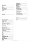
3-1. Connection Diagram
MAIN UNIT
Receiver cable
(Grey color)
5C Power Cable
RECEIVER
BATTERY
Ignition
-
+
Power Input Cable
TV
CONTROLLER
to Ignition
Use the 5C Power cable to connect between the controller and antenna.
The controller cable looks similar to the antenna receiver cable but you can distinguish
them by the color and labeling.
SatKing PRO MAX User manual - 7
6. Specifications
6-1. Dimension
MAX 57.5cm
MIN 27.0cm
27.0cm
51.8cm
56.9cm
6-2. Specification
MODEL NAME
SatKing PRO MAX
Weight
19.6 kg
Work Condition
Stationary
Polarization
Linear (Horizontal / Vertical)
LNB Output
Dual Output
LNB Input Frequency
11.7 ~ 12.75 GHz
LNB Output Frequency
1000 ~ 2050 MHz
Angle Range
(EL) 5° ~ 90° / (AZ) 390° / (SK) -60° ~ +60°
Satellite Searching Time
120 seconds (average)
Power Requirement
DC 12~24V
Power Consumption
84W (in searching)
Operating Temperature
-30°C ~ +60°C
SatKing PRO MAX User manual - 15
7. Camping Car Installation
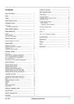
7-1 . Required space for the SatKing PRO MAX
Please allow that there is enough space around the SatKing Pro Max for flat antenna section
to complete a full 360° scan of the sky and return to the home position.
Vehicle rear
Center of
the rotation unit
20.5cm
44cm
59.5cm
51.8cm
A : Radius 30cm
up to a height 5cm
B : Radius 35cm
up to a height 12cm
C : Radius 50cm
up to a height 30cm
Driving direction
C : Radius 50cm
B : Radius 35cm
A : Radius 30cm
30cm
12cm
5cm
SatKing PRO MAX User manual - 16
Coverage Area Map Explained:
This map has been designed to let you know where you can receive both VAST
Satellite TV and Foxtel Satellite TV around Australia with the Pro Max
Automatic satellite system. The areas on this map in dark green are within the
coverage area for the Pro Max, this is where the majority of people live and
travel within Australia. The areas in light green are area’s that you should not
expect to receive a signal, these are areas less travelled and generally with
very little population. With any signal coverage map there can be some areas
within this map with lower than expected signal levels, we have tried to assure
accuracy within this map. In Australia the satellite TV signal is at it’s strongest
along the coast from Adelaide to the Queensland’s Sunshine Coast and there
are also high power spot beams on Perth and Darwin. Locations outside these
areas are covered by a lower power national beam.
How does satellite TV work:
Satellite TV comes from satellites than are in a geostationary orbit (they don't
move and are locked to the earths gravity) so they are always in the same
position. Satellite TV providers specially design the beam of the satellite to
cover where the population lives or travels. Satellite TV signal is not effected
by hills/terrain or distance from terrestrial transmitters like normal terrestrial
TV (digital TV) as the signal comes from a satellite in the sky. Satellite signals
can be effected by rain, heavy cloud, overhanging trees or by a building
blocking the northern sky (the building would need to be very close to the
system to block signal). When a satellite signal drops out or can’t be received
during a storm or heavy cloud normally you just need to wait until this weather
event passes and then normal service should resume. If you are in a lower
signal area a lesser rain or cloud event could block the signal, again just wait
for the weather to improve for normal service to resume.