1
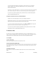
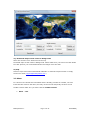
5) Bearing. It's not enough to have distance calculated. Get the bearing information too.
Check to enable it.
6) Max Resolution: The max resolution for the map. 30M, 10M, 5M and 1M per pixel.
10M, 5M and 1M per pixel resolution is provided for GPS Navigation purpose.
7) Max Items: Maximum items number of a thematic map can be displayed in screen at
the same time.
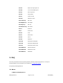
2.5 Keyboard Shortcuts
This is a full list of Keyboard Shortcuts for Earth Explorer. You can print this page out and
learn to utilize the keyboard shortcuts.
Motherplanet Inc..
Shortcut
Function
F1
Display/turn off Toolbar
F2
Display/turn off Status Bar
F3
Display/turn off List Panel
F4
Enable/disable Full screen mode
F5
List Panel on the right
F6
List Panel at the bottom
F7
List Panel on the left
F8
List Panel at the top
F9
Help Topics
F10
About
Ctrl+1
Political Boundaries
Ctrl+2
Coastlines
Ctrl+3
Rivers
Ctrl+4
Lat/Lon Grids
Ctrl+5
Countries
Ctrl+6
Cities Positions
Ctrl+7
City Names
Ctrl+8
Island Positions
Ctrl+9
Island Names
Ctrl+0
Earthquakes
Page 30 of 37
8/22/2009kj