1
S)))))))))))))))))))))))))))))))))
23A Durham Drive
Amherst, NY 14228
Galileo*Plot:
User Manual and Tutorial
Rev. June, 1993
S)))))))))))))))))))Q
PLOT
The Galileo Company
PLOT COPYRIGHT 1990 BY JOSEPH WOELFEL
ALL RIGHTS RESERVED
NO PART OF THIS PUBLICATION MAY BE REPRODUCED OR
TRANSMITTED IN ANY FORM OR BY ANY MEANS, ELECTRONIC OR MECHANICAL,
INCLUDINGPHOTOCOPY, RECORDINGORANYINFORMATION STORAGEANDRETRIEVAL
SYSTEM, WITHOUT PERMISSION IN WRITING FROM THE GALILEO COMPANY.
CATPAC, GALILEO, and ORESME are trademarks of The Galileo Company. All other brand and
product names are trademarks or registered trademarks of their respective companies.
PLEASE DON'T LOSETHIS PAGE. IT CONTAINS THE REGISTRATION NUMBER YOU WILL NEED
TO UPGRADE TO LATER RELEASES OF CATPAC.
Your Name
___________________________
Your Registration Number ___________________________
Version 3.0
Copyright 1990
The Galileo Company
All Rights Reserved
ii
The Galileo Company
IMPORTANT!
PLEASE READ CAREFULLY BEFORE USING THE SOFTWARE.
NOTIFICATION OF COPYRIGHT
THIS SOFTWARE IS A PROPRIETARY PRODUCT OF The Galileo CompanyAND IS PROTECTED
BY COPYRIGHT LAWS AND INTERNATIONAL TREATY. YOU M A Y MAKE A REASONABLE
NUMBER OF COPIES OF THIS PROGRAM FOR BACKUP PURPOSES, AND YOU MAY COPY THE
SOFTWARE TO THE HARD DISK OF A SINGLE COMPUTING PLATFORM OF THE TYPE
SPECIFIED IN YOUR LICENSE.
YOU ARE PROHIBITED FROM MAKING ANY OTHER COPIES OF THE SOFTWARE FOR ANY
OTHER PURPOSE BY COPYRIGHT LAWS. YOU M A Y MAKE ONE COPY OF THE WRITTEN
MATERIALS ACCOMPANYING THIS SOFTWARE FOR ARCHIVAL PURPOSES.
The Galileo Company
PLEASEREAD THIS LICENSEAGREEMENT BEFORE USINGTHE SOFTWARE. THIS AGREEMENT
IS A LEGAL CONTRACT BETWEEN YOU AND The Galileo CompanyGOVERNING YOUR USE OF
THIS SOFTWARE. USING THIS SOFTWARE INDICATES YOUR ACCEPTANCE OF THIS
AGREEMENT. IF YOU DO NOT WISH TO ACCEPT THE TERMS OF THIS AGREEMENT, PLEASE
RETURN THE UNOPENED SOFTWARE PROMPTLY TO The Galileo Company.. IF YOU HAVE ANY
QUESTIONS ABOUT THIS AGREEMENT, PLEASE CONTACT The Galileo Company, 23A Durham
Drive, Amherst, NY 14228.
TERMS OF LICENSE
THIS IS A N EXPERIMENTAL PROGRAM. WHILE The Galileo CompanyCERTIFIES THAT THE
HIGHEST STANDARDS OF DILIGENCE AND SCIENTIFIC INTEGRITY HAVE BEEN APPLIED TO
THE DEVELOPMENT OF THIS SOFTWARE, BY ACCEPTING THIS LICENSE YOU AGREE THAT
THIS IS EXPERIMENTAL SOFTWARE AT THE CUTTING EDGE OF SCIENTIFIC PROGRESS.
NOT A S MUCH IS KNOWN ABOUT THE PERFORMANCE OF NEURAL NETWORK TECHNOLOGY
iii
PLOT
The Galileo Company
A S IS KNOWN ABOUT TRADITIONALCOMPUTER SOFTWARE. YOU A S THE END USER AGREE
THAT REASONABLE AND PRUDENT CAUTION ABOUT THE APPLICATION OF RESULTS FROM
THIS SOFTWARE IS APPROPRIATE, AND The Galileo CompanyAGREES TO SHARE WITH YOU
(THE LICENSEE) RELIABLE ESTIMATES OF THE OPERATING PARAMETERS OF THE
SOFTWARE INSOFAR AS THEY ARE KNOWN BY TERRA.
The Galileo CompanyGRANTS YOU THE RIGHT TO USE ONE COPY OF THE SOFTWARE ON A
SINGLE-USER COMPUTER. EACH WORKSTATION OR TERMINAL ON A MULTI-USER
COMPUTER SYSTEM OR LOCAL AREA NETWORK MUST BE LICENSED SEPARATELY BY The
Galileo Company.
YOU MAY NOT SUBLICENSE, RENT OR LEASE THE SOFTWARE TO ANY OTHER PARTY.
YOU M A Y MAKE REASONABLE BACKUP OR ARCHIVALCOPIES IF THE SOFTWARE, BUT YOU
M A YNOT DISASSEMBLE, DECOMPILE, COPY, TRANSFER, REVERSEENGINEER OR OTHERWISE
USE THE SOFTWARE EXCEPT AS STATED IN THIS AGREEMENT.
LIMITED WARRANTY
The Galileo Company will replace defective diskettes that are returned within 90 days of the original
purchase date without charge. The Galileo Companywarrants that the software will perform
substantially as stated in the accompanying written materials. If you should discover any significant
defect and report it to The Galileo Companywithin 90 days of purchase, and Terra is unable to correct
it within 90 days of receipt of your report of the defect, you may return the software and Terra will
refund the price of purchase.
SUCH WARRANTIES ARE IN LIEU OF OTHER WARRANTIES, EXPRESSED OR IMPLIED,
INCLUDING, BUT NOT LIMITED TO, THE IMPLIED WARRANTIES OF MERCHANTABILITY AND
FITNESS FOR A PARTICULAR PURPOSE WITH RESPECT TO THE SOFTWARE AND THE
ACCOMPANYING WRITTEN MATERIALS. IN NO EVENT WILL The Galileo CompanyBE LIABLE
TO YOU FOR DAMAGES, INCLUDING ANY LOSS OF PROFITS, LOST SAVINGS, OR OTHER
INCIDENTAL OR CONSEQUENTIAL DAMAGES ARISING OUT OF YOUR USE OF OR INABILITY
TO USE THE PROGRAM, EVEN IF The Galileo CompanyOR AN AUTHORIZED TERRA
REPRESENTATIVE HAS BEEN ADVISED OF THE POSSIBILITY OF SUCH DAMAGES. The Galileo
CompanyWILL NOT BE LIABLE FOR ANY SUCH CLAIM BY ANY OTHER PARTY.
This limited warranty gives you specific legal rights. Some states provide other rights, and some states
iv
The Galileo Company
do not allow limiting implied warranties or limiting liability for incidental or consequential damages.
For this reason, the above limitations and/or exclusions may not apply to you. If any provision of this
agreement shall be unlawful, void or for any reason unenforceable, then that provision shall be
deemed separa ble from this agreement and shall not affect the validity and enforceability of the
remaining provisions of this agreement. This agreement is governed by the laws of the State of New
York.
U.S. Government Restricted Rights
The software and accompanying materials are provided with Restricted Rights. Use, duplication, or
disclosure by the government is subject to restrictions as set forth in subparagraph (b)(3)(ii) of the
Rights in Technical Data and Computer Software clause at 252.277=7013. Contractor/manufacturer is
The Galileo Company, 23A Durham Drive, Amherst, NY 14228.
v
PLOT
The Galileo Company
TABLE OF CONTENTS
Galileo*PLOT . . . . . . . . . . . . . . . . . . . . . . . . . . . . . . . . . . . . . . . . . . . . . . . . . . . . . . . . . . . . . . . . . . . . . . . . . 1
Running the DEMOPLOT Program . . . . . . . . . . . . . . . . . . . . . . . . . . . . . . . . . . . . . . . . . . . . . . . . . . . . . . 1
Running Galileo*PLOT . . . . . . . . . . . . . . . . . . . . . . . . . . . . . . . . . . . . . . . . . . . . . . . . . . . . . . . . . . . . . . . . . 2
Selecting a file to display . . . . . . . . . . . . . . . . . . . . . . . . . . . . . . . . . . . . . . . . . . . . . . . . . . . . . . . 2
Magnifying and Shrinking the Plot . . . . . . . . . . . . . . . . . . . . . . . . . . . . . . . . . . . . . . . . . . . . . . 3
Interpreting the Plot . . . . . . . . . . . . . . . . . . . . . . . . . . . . . . . . . . . . . . . . . . . . . . . . . . . . . . . . . . . 3
Alternative Displays -- 2D and 3D . . . . . . . . . . . . . . . . . . . . . . . . . . . . . . . . . . . . . . . . . . . . . . . 5
Comparing Maps -- Rotations and Reflections . . . . . . . . . . . . . . . . . . . . . . . . . . . . . . . . . . . . 5
The World as we Know It . . . . . . . . . . . . . . . . . . . . . . . . . . . . . . . . . . . . . . . . . . . . . . . . . . . . . . 8
Stereographic Projection . . . . . . . . . . . . . . . . . . . . . . . . . . . . . . . . . . . . . . . . . . . . . . . . . . . . . . 10
Mathematical Analysis: Moving Beyond Mere Appearances . . . . . . . . . . . . . . . . . . . . . . 11
Summary . . . . . . . . . . . . . . . . . . . . . . . . . . . . . . . . . . . . . . . . . . . . . . . . . . . . . . . . . . . . . . . . . . . . . . . . . . . . 17
Input to Galileo*PLOT . . . . . . . . . . . . . . . . . . . . . . . . . . . . . . . . . . . . . . . . . . . . . . . . . . . . . . . . 17
The format header . . . . . . . . . . . . . . . . . . . . . . . . . . . . . . . . . . . . . . . . . . . . . . . . . . . . 17
The Coordinates . . . . . . . . . . . . . . . . . . . . . . . . . . . . . . . . . . . . . . . . . . . . . . . . . . . . . 18
The Concept Labels . . . . . . . . . . . . . . . . . . . . . . . . . . . . . . . . . . . . . . . . . . . . . . . . . . 18
The Errors . . . . . . . . . . . . . . . . . . . . . . . . . . . . . . . . . . . . . . . . . . . . . . . . . . . . . . . . . . . 18
A Sample Coordinate File . . . . . . . . . . . . . . . . . . . . . . . . . . . . . . . . . . . . . . . . . . . . . . 18
Printing the Picture . . . . . . . . . . . . . . . . . . . . . . . . . . . . . . . . . . . . . . . . . . . . . . . . . . . . . . . . . . . 19
Appendix 1: Tools . . . . . . . . . . . . . . . . . . . . . . . . . . . . . . . . . . . . . . . . . . . . . . . . . . . . . . . . . . . . . . . . . . . . 21
vi
The Galileo Company
Galileo*PLOT
The main reason most analysts u s e a perceptual mapping (or multidimensional scaling
program) is to obtain a visualization of their data. Often, the complex relationships among a set of
words or numbers can be more easily understood when they are displayed in the form of a map.
Two distinct steps are always involved in constructing any map. First, some mathematical
procedure is required to transform raw data into a set of coordinates which can be plotted as a spatial
diagram. And secondly, these coordinates must be transformed into the actual picture we can see.
There are many different analytic procedures that can produce a set of coordinates. These
include: non-metric multidimensional scaling, metric multidimensional scaling, principle components,
discriminant analysis, and correspondence analysis.
Regardless of the method used to obtain a set of coordinates, Galileo*PLOT can read these
coordinates and generate a technically superior map, and then be used to conduct several value-added
analyses which are not obtainable from any other program. Let us now review some of the capabilities
of Galileo*PLOT
Running the DEMOPLOT Program
DEMOPLOT is the demonstration version of Galileo*PLOT. It has the full functionality of
Galileo*PLOT, but is only able to read the demonstration data files supplied with the program. To run
DEMOPLOT, insert the diskette into one of the drives on your computer, then re-set your default
drive to that drive. For example, If you put the diskette in drive A, type A: and then press the [ENTER]
key. Then type the word DEMO and then press the [ENTER] key.
There will be a brief pause while your computer loads the program from the diskette into
RAM. The program will run much faster if you copy the files on your diskette into a directory on the
hard drive, but will still work just fine even on your floppy drive. After a few moments, DEMOPLOT
will produce a three-dimensional perceptual map. Mapped on the coordinates are three concepts -TERRA, PRECISION, and SOFTWARE. To the left of the map is a menu of the basic commands you
use to run Galileo*PLOT.
Running Galileo*PLOT
Galileo*PLOT can either be run as a stand alone program or as part of the Galileo System.
1
PLOT
The Galileo Company
To run Galileo*PLOT by itself, simply type
c:\galileo\runner\plot
and then press the [ENTER] key
If you have put the \galileo\runner directory into your path, you will only have to type
PLOT
and then press the [ENTER] key.
If you are operating Galileo*PLOT within the Galileo System, Galileo*PLOT is option 13
on the menu at the left of the Galileo screen. Simply type 13, and then press the [ENTER] k e y .
Galileo*PLOT will instantly produce a three-dimensional perceptual map. Mapped on the coordinates
are three concepts -- TERRA, PRECISION, and SOFTWARE. To the left of the map is a menu of the
basic commands you use to run Galileo*PLOT.
Selecting a file to display
Press the [F1] function key (Get Coordinate File) and at the prompt, type SHOBIZ.CRD and
then press the [ENTER] key. This command tells the program to make a map using the coordinates
contained in the file SHOBIZ.CRD and display the image in the window at the right side of the screen.
(You may name a coordinate file anything you wish, but at Terra, we end all coordinate file names in
the qualifier .CRD)
Magnifying and Shrinking the Plot
What you are looking at is a three-dimensional plot containing the names of several popular
entertainers, and a set of attributes that might be used to describe these entertainers. At first glance,
you might find this image too small to read comfortably. In an ordinary plotting program, if this
happens, well, there's not too much you can do about it. But with Galileo*Plot, there's no problem;
Galileo*PLOT has the capability to increase the size of the visual display, just press the [m] key on
your keyboard.
"M" stands for "magnify," and Galileo*PLOT will then ask you how much you want to
magnify the picture using the prompt (GAIN?).
2
The Galileo Company
Type in the number 1.5 and then press the [ENTER] key.
Galileo*PLOT will produce a picture that is 1.5 times larger than the first image you saw.
You can "blow-up" the size of the image produced by Galileo*PLOT to any size, but as the
image becomes larger, you'll notice that some of the labels (like Madonna) will be pushed off the
screen. If you would like to view this example without losing any of the labels -- press the letter [m]
and type 1.25
Interpreting the Plot
The image you see is a 3 dimensional perceptual. To help you visualize the third dimension,
a "floor" is projected on the xz plane, and "stems" have been dropped from the name of each
entertainer to the floor to help you grasp the location of each concept on the third (z) dimension.
If the entertainer's name is under the xz plane, the stems are raised up to meet the floor. Where
each stem touches the floor, a little "foot" -- i.e., a small cross -- is drawn.
Some people have a knack for reading maps, while others have a hard time judging spatial
relations. Fortunately, the map made by Galileo*PLOT is quite easy to understand, and is interpreted
in the following manner: concepts that are highly associated (or similar) are located near each other;
the further apart the concepts, the less similar (or associated) they are.
To the right-side of the space you'll see the concept FEMALE, and clustered close to
FEMALE are MADONNA, JANE FONDA and ....MICHAEL JACKSON (?)
On the left side of the screen, you'll find the concepts MALE, GEORGE BURNS and
WALTER CRONKITE. Notice that close to GEORGE BURNS and WALTER CRONKITE is the
concept OLD. Close to Walter Cronkite is also the concept RELIABLE, and close to GEORGE BURNS
is the concept FUNNY.
Near the top of the map you'll find the concepts PUNK and THE RAMONES. You'll also
notice the concept YOURSELF is located in left-center of the plot.
These coordinates were made by the perceptual mapping program Galileo*MICROGAL, and
represent the responses of one middle-aged male respondent. This man ("You" in the plot) is between
3
PLOT
The Galileo Company
GEORGE BURNS and WALTER CRONKITE, who are older than he is, and THE RAMONES,
MADONNA, and MICHAEL JACKSON, who are younger. He's not too far from JANE FONDA,
though, who is definitely in his age group.
Many analysts have been led to believe that you must have several cases to make a good
perceptual map, but this plot was made from the responses of JUST ONE PERSON.
Alternative Displays -- 2D and 3D
You might not be accustomed to a 3 dimensional map -- in fact, most conventional mapping
programs can only make a 2 dimensional plot. If you would like to see a 2 dimensional representation,
press the [F6] function key. This map is definitely easier to read, but also provides a great deal less
information than the 3-D version.
You can toggle back and forth between the two dimensional and three dimensional display
by pressing the [F6] function key. After toggling a few times, return to the 3-D mode.
Comparing Maps -- Rotations and Reflections
There's a lot more to learn about Galileo*PLOT, but it might be best to leave this example
and choose another. Press the [F1] function key again and at the prompt, type FEMALES.CRD and
then press the [ENTER] key.
What you're seeing is a map representing the opinions of about 150 female voters living in
and around Albany, NY about the candidates and issues involved in the 1988 presidential election.
These coordinates were also made by the Galileo method, this time by the renowned Galileo Version
5.5 mainframe program. We think it provides a classical picture of the political spectrum.
At the far left we see the concepts LIBERAL and, almost at the same spot, DUKAKIS. Near
these two concepts, you will also see the concept PRO-CHOICE.
On the right side of the screen, you will see the concept CONSERVATIVE, along with the
concepts RONALD REAGAN and GEORGE BUSH. Near the top and at the back of the plot is the term
EVIL, and, closest to EVIL (surprise!) TAXES.
If you study the picture carefully, you will notice that the perceptions of these women follow
4
The Galileo Company
conventional political wisdom. You'll also notice that the concept YOURSELF lies toward the left of
the plot, closer to DUKAKIS than to BUSH. Women in Albany and environs voted heavily for
Dukakis in 1988. Albany is a traditionally Democratic city, and has a Democratic mayor for the past
50 years!
If the plot is not clear to you, try magnifying and shrinking it until you can see every concept
clearly. (How clear the plot is depends entirely on your computer...the Galileo*PLOT program studies
your computer and automatically makes the most precise plot your screen is able to display.)
Remember, type [m] and then press the [RETURN] key to change the size of the display -typing a number larger than 1.0 will magnify the picture, while a number smaller than 1.0 will shrink it.
If you want to view the image in 2 dimensions instead of 3, press the [F6] function key.
Now you can learn something very important about the real power of Galileo*PLOT. Press
the [F1] function key again. This time at the prompt, type MALES.CRD and then press the [ENTER]
key.
What appears now is a map representing the opinions of about 150 men drawn from the same
geographic area (Albany, NY). If you study this map carefully, you will notice that the men's plot is
exactly backward from the women's plot.
Look at the concepts CONSERVATIVE, REAGAN and BUSH. They are now on the left-side
screen, before, they were on the right-side of the screen. Similarly, the concepts DUKAKIS and
LIBERAL are on the right-side of the screen; before, they were on the left.
Does this mean the men's opinions were radically different from the those of the women? Not
exactly.
What few people realize about perceptual mapping algorithms is that none of them -- not even
the extremely precise Galileo algorithm -- have any idea what orientation people prefer to view. In the
world of mapping, there is no such thing as UP, or DOWN, or LEFT or RIGHT.
It has only been quite recently that people have agreed (on an international level) to draw
maps of physical space with "north" at the top of maps and "east" at the right. But no
multidimensional scaling or perceptual mapping software "knows" about these agreements.
5
PLOT
The Galileo Company
Perceptual mapping programs are like cameras dangling on a string. They can make an
accurate picture, but the direction the camera is facing at the moment the picture is snapped is
determined by the shape of the space without any regard for conventional standards. Before you can
compare any two "pictures" made by a perceptual mapping program, you must adjust for the arbitrary
orientation of the pictures.
Galileo*PLOT makes this simple. Just press the [right arrow] key on your keyboard. It looks
like this [->]. At the prompt, type 180 and then press the [RETURN] key.
Galileo*PLOT will rotate the picture 180 degrees to the right. Now you'll see the men's map
using the same orientation that was used to display the women's map.
If your memory serves you well, you will see that both the men and the women pretty-much
agree about where the candidates and issues lie in the space. But you should also notice one very
important difference, the location of the concept YOURSELF.
In this (the men's) space, the location of YOURSELF is considerably further to the right than
it was in the women's space. That is, these men positioned themselves much closer to concepts
CONSERVATIVE and BUSH.
Previous research has shown that political candidates positioned closest to the concept
YOURSELF tend to gather more votes. Consequently, after viewing this map and comparing it the
women's map we discussed earlier, we would conclude that the men preferred (and were more likely
to have voted for) BUSH, while the women preferred (and were more likely to have voted for)
DUKAKIS.
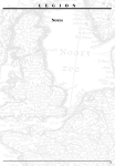
The World as we Know It
There is still a great deal to tell you about what Galileo*PLOT can do, but let's leave this
example and turn to another. Press the [F1] function key again, and at the prompt type WORLD.CRD
and then press the [RETURN] key.
What you see now is a map of the world. But its looks are deceiving.
Do you REALLY think that Cairo and Johannesburg are close to each other?
6
The Galileo Company
How about Havana (hot hot hot) and Toronto (brrrrrr!)?
Paris and Rio de Janeiro?
What's going on? Let's start simplifying the picture.
Press the [F6] function key to change to a 2 dimensional display.
YIPES! That didn't help much did it?
Do you think Cairo, Johannesburg and Moscow(!) are near each other?
How about Sidney and Tokyo?
And why are Havana and Tokyo right on top of each other?
Now for some really bad news.
This is not a perceptual map based on human judgments of distance. This plot is based on
the actual straight-line geographic distances between these cities. The coordinates were produced
using Galileo*MICROGAL and are accurate to the nearest mile! Yet the map you see on the screen,
while technically correct, is hard to read and quite misleading. How can this be?
Try this.
First, press the [up arrow] key and at the prompt type 90 and then press the [ENTER] key.
This will rotate the plot 90 degrees upward.
Now, press the [right arrow] key and at the prompt type 180 and then press the [ENTER]
key.
This string of commands has changed the orientation of the map and provided you with a
view of the world as it would look if you were travelling in a satellite above the Pacific Ocean.
If you're like most Americans and have no s e n s e of geography, get a globe (preferably a
transparent globe) and look at it from this perspective. This view of the world should makes a little
7
PLOT
The Galileo Company
more sense to you, but there is still a small problem with the display.
Stereographic Projection
To grasp the problem, you'll need to put on the stereographic glasses provided with this
program. Place the blue lens over your right eye, and the red lens over your left eye.
Press the [F6] function key to change to a 2 dimensional plot. Then, press the [F9] function
key to switch to a stereographic projection.
Put on the glasses.
It will probably take you a few moments to stop laughing and adjust to wearing the glasses,
but once you do, the map should take on a solid or 3 dimensional perspective.
If you carefully study the plot, you will notice that MOSCOW, PARIS, and CAIRO are
"close" to you, while TORONTO, LAS VEGAS, and HAVANA are "far" from you. This is wrong, or,
perhaps more accurately, unconventional. What has happened is that the third dimension (depth) has
been "reflected."
Walk away from the computer, and go to the nearest mirror. Look in the mirror, and notice that
what you see is, well, a MIRROR IMAGE of reality. But notice that the distance relations in the
mirror, although backward, are identical to the distances in real life . NO multidimensional scaling
or perceptual mapping program -- not even the super precise Galileo program -- can tell the difference
between "mirror world" and the real world.
Often (about one chance in 2) ANY perceptual mapping program will produce mirror
coordinates instead of "real" coordinates. In this case, the scaling solution has reflected the third
dimension, giving a mirror image of the depth.
Galileo*PLOT was designed to deal with reflection, and provides you the ability to reflect
any map, and thereby increase the number of perspectives from which you may study it.
With your stereographic glasses on, type the letter [r] and then press the [ENTER] key. "R"
stands for REFLECT. The prompt will ask you the number of the dimension you want to reflect. In
Galileo*PLOT, the number 1 represents the x axis, 2 represents the y axis, and 3 represents the z axis.
8
The Galileo Company
Since we want to reflect the map along the z axis, type 3 then press the [ENTER] key.
Galileo*PLOT will reflect the map, and suddenly the world looks a little more familiar.
Mathematical Analysis: Moving Beyond Mere Appearances
The examples we have discussed thus far were not only developed to so show you what
Galileo*PLOT can do, they were also meant to caution analysts who interpret maps by simple visual
inspection. While we all know that maps that "look good" tend to get used more often than maps that
don't, you must keep in mind two things:
(1)
even "bad looking" maps still contain a considerable amount of
technically correct information that is available for analysis; and
(2)
sometimes, "good looking" maps can be extremely misleading.
This is because most complex (multidimensional) relationships cannot be fully expressed in
just 2 or 3 dimensions. That is, the map is incapable of giving you complete information about the
nature of these relationships. In as much, important information may be difficult to grasp, appear
distorted, or (worse) completely hidden from view.
While perceptual maps can be very useful, drawing conclusions by only viewing the picture
is (pardon the pun) short-sighted, and can lead to serious problems. Fortunately, Galileo*PLOT has
some very powerful mechanisms to keep you from being misled by appearances. Press the [F1]
function key again, and this time call up the file TOTAL.CRD
This perceptual map is a representation of the opinions of both the men and women voters
we discussed earlier. W e s imply combined the two data sets, and made a perceptual map using
Galileo*MICROGAL.
Press the [right arrow] key, then press the [ENTER] key, and at the prompt type 180 [ENTER]. This
string of commands will rotate the map so that concept LIBERALnow appears on the left-side of the
screen, and the concept CONSERVATIVE is on the right-side of the screen.
Those of you who like to u s e political jargon like... "the conservative right-wing", or "leftist
liberals" should enjoy the intuitive logic underlying this map.
9
PLOT
The Galileo Company
Suppose you've been retained by the Bush campaign to provide strategic advice about how
to win in Albany. Using this map you notice that the concepts HONEST and LIKEABLE are located
near the concept YOU.
You know from previous research that these attributes are important to voters, so you
postulate that one way of improving Bush's chances of winning might be to try and somehow
associate him with these two attributes.
Now, even though several paragraphs have passed since our very stern warning, you
remember that even the best perceptual maps can often be misleading, masking complete information,
making things which are really quite far apart seem close together. So you think to yourself, is there
a way to check your intuitive judgments in an objective way? You bet!
Press the [F4] function key, and the program will ask you to name the START concept (or
concepts). The START concept(s) are the concepts you wish to reposition (or move).
Type the word BUSH at the prompt, then press the [RETURN] key, then press the [ F 5 ]
function key.
T he program will display a prompt which ask you for a TARGET. The TARGET is the
location toward which you want to move. At the prompt, type the word YOU, then press the
[RETURN] key, and then press the [F5] function key.
Finally, the program will ask you to enter the MESSAGE concepts. The MESSAGE concepts
are the one you wish to associate with the START concept. Type the word HONEST, press the
[RETURN] key, then type the word LIKEABLE, press the [RETURN] key, and then press the [F5]
function key.
The program will almost instantaneously evaluate the strategy you have concocted, using
the complete information about all concept relationships contained in the entire coordinate matrix -not only the first three dimensions from which the visual display is derived. The message you see
displayed on the left-side of your screen provides you with information on the potential effectiveness
of your strategy. The program has run a simulation of the strategy, and then displayed the projected
result.
When looking at a two dimensional euclidean projection of what is perhaps a fifteen, twenty
10
The Galileo Company
or even more dimensional non euclidean space, even the most brilliant analyst may often be misled.
But no matter how many dimensions may underlie a space, and regardless of whether the space is
euclidean or riemannian, the Strategy algorithm will not be misled.
These results show that the distance between the concepts BUSH and YOU is 57.33 units.
It also tells you that a strategy which attempts to associate BUSH with the concepts HONEST and
LIKEABLE, if successful, will leave you 29.6 units from your target (the concept YOU). Finally, it tells
you that 29.6 units is 50.69 percent of the present distance, which means that your strategy has the
potential to improve Bush's position by about one-half.
The important point to keep in mind here is that these procedures can produce meaningful,
useful results regardless of the appearance of the visual display. Whether you find the plot
interpretable or not is largely irrelevant; the strategy algorithm uses information contained in the
coordinate matrix, and so, can always be used to perform advanced analyses and provide you with
effective strategic advice. Moreover, the program can do this no matter how many dimensions are in
the space -- or even if the space is non-euclidean.
(To exit STRATEGY, press the [F7] function key.)
Displaying Crowded Spaces
Until now, most perceptual maps were made using only a few concepts. This was because
maps which displayed a lot of concepts were often quite difficult (and costly) to make. Further, when
working with a lot of concepts, maps like these often become very crowded and difficult to read.
But now, new analytic technologies (like neural networks) are making it quite easy to make maps
containing scores of concepts. More importantly, as the global economy grows and our world
becomes increasingly complex, the need to make brand (or perceptual) maps that can contain a large
number of concepts is becoming more and more acute.
To see how Galileo*PLOT can help you deal with complex images, press the [F1] function
key, type CITIES.CRD and then press the [ENTER] key.
What you will see is a perceptual map made from text. This "text" represents the verbatim
comments of three people describing Buffalo, Detroit and San Diego. This text is on your diskette in
the file CITIES.TXT. (If you've installed your software, it's in the \GALILEO\DATA directory.)
11
PLOT
The Galileo Company
A computer program called Galileo*CATPAC read these interviews, and then created the
coordinates contained in the file CITIES.CRD.
A s you can see, there are three distinct clusters of concepts in this plot, but some of the
concepts are so close together they can't be read at all. Fortunately, using Galileo*PLOT, you can
simplify and clarify the picture very easily. Here's how:
First, magnify the space by pressing the [m] key, type 2 and then press the [ENTER] key.
Now, rotate the map to the right 45 degrees. Do this by pressing the [right arrow] key, then
type 45 and then press the [ENTER] key. This should clear up the SAN DIEGO cluster very nicely.
Now rotate the map upward 45 degrees -- using the [up arrow] key, then typing 45 and then
pressing the [ENTER] key.
You should see three distinct clusters. Within each cluster is the name of a city, and the
attributes most associated with each city. (You can review the interviews by examining the file
CITIES.TXT, and you'll find that the solution is remarkably accurate.)
Now press the [F2] function key. This command allows you to control 2 features: (1) how fast
the map is made, and (2) the number of concepts that will be displayed.
The first prompt will ask you if you want to u s e the quick (Q) or slow (S) display option. Type
the letter [s] for slow, and then press the [ENTER] key.
At the next prompt, the program will ask you if you wish to review concepts by their labels
(L) or their number (N).
For now, lets use the label (L) option... so type the letter [L] and then press the [ENTER] key.
Almost immediately, the program will list the first concept-label contained in the coordinate file, and
wait for you to make a decision on whether or not you want this concept displayed in the plot.
If you want the concept displayed, you would press the [F2] function key to skip to the next
concept-label. If, however, you do not wish to have the concept displayed in the map, you would first
press the [F1] function key, which tells the program to suppress this particular concept-label, and then
12
The Galileo Company
press the [F2] function key to skip to the next concept-label.
You can tell if a concept will be displayed or not by the asterisk which precedes the conceptlabel. If an asterisk precedes the concept-label, that concept will be included in the display. If the
asterisk is not present, the concept will be deleted from the display.
Once you have made a decision regarding each concept, the program will begin creating the
map. With each tap of any key, a new concept will be added to the map. Concepts are added to the
display, one by one, until all the concepts that you requested be displayed have been added to the
map.
This "slow display" option can be quite useful when you want to study the relative location
of concepts. Just remember, "looks" aren't everything.
Summary
This brief demonstration only touches on a few aspects of the capabilities of Galileo*PLOT.
Galileo*PLOT greatly expands the usefulness of perceptual maps, and provides new and powerful
ways to u s e them. Rather than simply viewing a single two-dimensional map, usually printed on
paper, that may or may not be oriented in the most convenient and viewable way, Galileo*PLOT lets
you interact with the plot. You can turn it around, blow it up or shrink it, flip it over, reflect it, remove
or add concepts, move closer to it or farther from it, and see it in ways that are just not possible
without Galileo*PLOT. And, as you form judgments about distances and strategies for repositioning
products or candidates, you can test them to surpassing precision with Galileo*PLOT's built in
proprietary mathematical routines.
We encourage you to call up any of the demonstration plots provided on the diskette and
experiment with the features we have discussed.
Of course, Galileo*PLOT has context-sensitive on-line help, and you can learn a great deal
about the program by simply pressing the [F3] function key at any prompt.
Input to Galileo*PLOT
Galileo*PLOT reads coordinate files in any standard ASCII format. The program expects to
find four elements in the coordinate file: the format header, the coordinates, the concept labels, and
13
PLOT
The Galileo Company
the standard errors.
The format header
The format header is a standard format statement, followed by three 3-digit integers which
give, respectively, the number of concepts, the number of real dimensions, and the total number of
dimensions. Following these numbers a title up to 40 characters may follow:
(8f10.4) 018012018 Auto Test Data .
This header says that the coordinates will be found in (8f10.4) format, that there are 18
concepts, 12 real dimensions and 18 total dimensions in the space, and that the titl e o f t h e s e
coordinates is "Auto Test Data."
The Coordinates
Following the header come the actual coordinates, in the format described in the header.
The Concept Labels
Following the coordinates, Galileo*PLOT expects to find the concept labels, one per line, in
A40 format.
The Errors
Several Galileo programs are able to calculate confidence intervals around the location of
points in the perceptual map. If these are available, the are arrayed following the concept labels in
(11F7.3) format. Galileo*PLOT uses these errors to determine the size of the circle used to represent
the concept's position. If these errors are not present, Galileo*PLOT provides default values.
A Sample Coordinate File
(6F12.4)
7 4 7DESERT PREFERENCES
56.1659
-4.6299
-6.3528
3.1023
20.6566
-49.8766
-1.8973
3.0467
9.7793
4.2251
1.2211
-18.0480
3.1706
-7.7617
-5.5885
28.5394
1.0056
17.5189
2.9665
-11.2909
-40.7849
8.4968
3.6503
-7.3565
15.8414
20.6520
20.3833
-4.9479
-2.0051
-9.6510
-15.9168
-5.3104
-16.0858
1.2752
-14.1927
HOT
COLD
SWEET
CHERRY PIE
ICE CREAM
TOM
BECKY
4.537 4.360 3.889 3.005 1.827 2.593 3.359
.9094
.7301
-.8078
-8.6278
.0200
-10.0956
.4623
9.2294
8.0289
.3342
-10.4801
-.2576
11.2150
14
-.6609
The Galileo Company
Galileo*PLOT will automatically read any .CRD file created by any GALILEO program
including: CATPAC, ORESME, MICROGAL, or GALNET Galileo*PLOT can also read coordinates
made by V55, but these will need some simple editing described in the V55 manual.
GALNET is a very general program that can generate a set of coordinates using any square
matrix of dissimilarities, similarities, covariances, or correlations.
GALNET can also make a set of coordinates using any rectangular (objects by attributes)
matrix in which each row represents some object and each column represents some attribute.
With GALNET, you can access the power of Galileo*PLOT using almost any kind of data
input. And at the heart of GALNET is the respected GALILEO metric scaling algorithm -- an algorithm
that never distorts your data to fit into a preconceived space. Most multidimensional scaling or
perceptual mapping algorithms stretch, shrink, or otherwise transform your data to force them to fit
into a limited number of dimensions. Galileo programs are fully metric, however, and never modify your
data. What you measured is what you get -- undistorted and unchanged.
Printing the Picture
Galileo*PLOT is mainly a screen display program and does not support printing internally.
Once you have produced an image you like on the screen, the display can be captured by a screen
capture utility (like the "grab" utility in WordPerfect). This image can then be imported into text files
with your word processor and made a part of reports and other documents.
This image can be
enhanced before "grabbing" by press F10. This will turn all the concepts in the display white, which
greatly increases their readability in a printed image.
How clear and finely detailed these pictures will be is determined solely by the degree of
resolution of your own computer's graphics, since it is the actual pixel display on the screen that is
captured and written to the file. If you do not have a screen capture utility, contact your Terra
representative, who can help you find one that's right for you.
15
PLOT
The Galileo Company
Appendix 1: Tools
Your Galileo installation includes a directory called GALILEO\TOOLS. On this directory Terra
has supplied three helpful DOS tools. First is a simple read only editor called LOOK. LOOK is a
public-domain program which allows you to examine the contents of any file interactively. It is
convenient since you can page up and down or scroll up, down, left and right in the file using the
cursor control keys. You can also easily read the 132 column format files that V55 writes. And, since
LOOK is a read only editor, you don't run the risk of altering important files.
To use LOOK, simply enter the command
LOOK [filename]
at the DOS prompt. To leave LOOK, press [ESC].
Also included is a very powerful ASCII editor, EDWIN. EDWIN is a public domain program
which follows the formats of WORDSTAR, and can be very helpful in modifying files produced by
V55 for use in the other Galileo programs and vice versa. EDWIN has complete online help, accessed
by pressing F2 once in the program. To start EDWIN, simply enter the command
EDWIN
at the DOS prompt. You can also enter a file directly with EDWIN by entering the command
EDWIN [filename]
.
If you already have an ASCII editor you favor, you may u s e that instead of EDWIN. For
more information on installing and using EDWIN, consult the documentation provided on the
\GALILEO\TOOLS directory.
The last tool provided is called UP. Up lets you climb up your directory tree in only three
keystrokes. If your default directory, for example, is GALILEO\DATA, then issuing the command
UP
at the DOS prompt will set your default directory to \GALILEO. Issuing the command again will move
you to the root directory.
All three of these utilities are public domain software and are neither warranted nor supported
by The Galileo Company, Terra Research and Computing or any of their agents. The are provided at
16
The Galileo Company
no charge as a convenience for the user.
Note that authors of public domain software sometimes request voluntary payments from
users for the u s e of their programs. No such payments have been made on your behalf by Terra,
Galileo or any of their representatives.
17