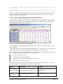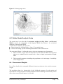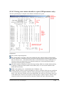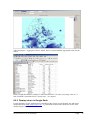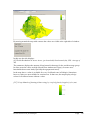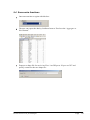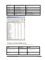
1
LEAP version 2.61 for Ethiopia User manual Peter Hoefsloot Sandro Calmanti Consultant to the World Food Program April 17, 2012 Government of Ethiopia World Bank World Food Program Of the United Nations The Livelihoods Integration Unit (LIU) supported by USAID Food and Agriculture Organization of the United Nations Table of Contents Acknowledgements ................................................................................................................. 5 1 Introduction ..................................................................................................................... 6 1.1 Developing weather based indexes .......................................................................... 6 1.2 The Ethiopian experience ......................................................................................... 7 1.3 LEAP: a software platform to calculate weather based indexes .............................. 7 1.4 The incorporated LIU database ................................................................................ 8 1.5 Getting the software and more information ............................................................. 8 1.6 Compatibility with other software............................................................................ 8 1.7 Disclaimer ................................................................................................................ 9 2 LEAP Basics ................................................................................................................. 11 2.1 Prerequisites for using LEAP ................................................................................. 11 2.2 Installing the program ............................................................................................ 11 2.3 Starting LEAP ........................................................................................................ 13 2.4 Indexes produced by LEAP.................................................................................... 13 2.5 Pre-loaded datasets ................................................................................................. 14 2.6 Dataset priority ....................................................................................................... 15 2.7 Crop baskets ........................................................................................................... 16 2.8 Getting new data..................................................................................................... 17 2.9 The Visual Menu .................................................................................................... 18 2.10 Projects ............................................................................................................... 19 2.10.1 Starting a new project ..................................................................................... 20 2.10.2 Opening an existing project ............................................................................ 20 2.10.3 Saving the current settings .............................................................................. 20 2.10.4 Deleting a project ............................................................................................ 21 3 Working with meteorological data................................................................................ 22 3.1 Rainfall ................................................................................................................... 22 3.1.1 RFE1 Rainfall archive..................................................................................... 22 3.1.2 RFE2 Rainfall archive..................................................................................... 23 3.1.3 The ARC rainfall archive ................................................................................ 25 3.1.4 The TAMSAT rainfall archive........................................................................ 26 3.1.5 The NMA Rainfall archive ............................................................................. 28 3.1.6 Combining NMA point data and satellite-based data to a new rainfall estimate 32 3.1.7 Comparing the quality of images in datasets .................................................. 33 3.1.8 What to do after importing new rainfall data .................................................. 34 3.1.9 Viewing the rainfall data ................................................................................. 35 3.2 Potential evapotranspiration (ET0) ........................................................................ 36 3.2.1 Importing and calculating NMA actual ET0 .................................................. 37 3.2.2 Viewing the ET0 data in the viewer ............................................................... 40 4 Working with crop data ................................................................................................ 41 4.1 Working with crops and crop characteristics ......................................................... 41 4.2 Working with zonal crop data ................................................................................ 42 4.2.1 Check the Zones and their names ................................................................... 42 4.2.2 Editing zonal data ........................................................................................... 43 LEAP version 2.61 for Ethiopia Page 2 4.3 How to add a crop .................................................................................................. 45 4.3.1 Step 1. Adding a base crop ............................................................................. 45 4.3.2 Step 2. Adding crop coefficients ..................................................................... 46 4.3.3 Step 3. Add the crop to the basket crop list .................................................... 46 4.3.4 Step 4. Add the new crop to the Zonal spreadsheet ........................................ 47 4.3.5 Step 5. Import the zonal sheets ....................................................................... 48 4.4 Determining planting dekads ................................................................................. 48 4.5 Specifying planting dates manually ....................................................................... 49 4.6 Viewing zonal images ............................................................................................ 49 5 Calculating the crop indexes ......................................................................................... 51 5.1 Calculating the water balance (WRSI) ................................................................... 51 5.2 Calculating a basket WRSI .................................................................................... 52 5.3 Comparing data to Normals ................................................................................... 53 5.4 Calculating the Yield Reduction ............................................................................ 53 5.5 Basket Yield Reduction .......................................................................................... 54 5.6 Calculating the Moisture Index .............................................................................. 54 6 The needs computation module .................................................................................... 56 6.1 The log-model ........................................................................................................ 56 6.2 The Needs module .................................................................................................. 58 6.3 Select a target area.................................................................................................. 58 6.4 Define Needs Analysis Setup ................................................................................. 59 6.4.1 Assessment Weights ....................................................................................... 59 6.4.2 Log-model parameters .................................................................................... 60 6.4.3 Few recommendation for parameter selection. ............................................... 62 6.5 Needs Computation ................................................................................................ 63 6.6 Checklist ................................................................................................................. 64 7 Normalized Difference Vegetation Index (NDVI) in LEAP ........................................ 66 8 The LEAP image viewer ............................................................................................... 68 8.1 Selecting the image to view ................................................................................... 68 8.2 The Viewer main screen ......................................................................................... 68 8.2.1 Selecting another image .................................................................................. 69 8.2.2 The legend ....................................................................................................... 69 8.2.3 Comparing the image values to normal .......................................................... 70 8.2.4 Getting pixel details ........................................................................................ 71 8.2.5 Masking out areas in the viewer ..................................................................... 74 8.2.6 Changing the boundaries................................................................................. 74 8.2.7 Zooming and Panning ..................................................................................... 75 8.2.8 Aggregate to Excel .......................................................................................... 75 8.2.9 Display values in Google Earth ...................................................................... 76 8.2.10 Exporting images to ArcGIS and ArcView .................................................... 77 8.2.11 Copying images to Word ................................................................................ 78 9 Using data from the LIU database. ............................................................................... 79 9.1 Displaying LIU data in LEAP ................................................................................ 79 9.2 Looking for a parameter ......................................................................................... 81 9.3 The LIU parameter legend ..................................................................................... 82 9.4 Some extra functions .............................................................................................. 84 10 Additional Data available in LEAP .............................................................................. 85 10.1 Livestock Early Warning System Forage Maps ................................................. 85 10.2 NDVI .................................................................................................................. 86 11 Exporting LEAP data to other software ........................................................................ 87 LEAP version 2.61 for Ethiopia Page 3 11.1 Export Rainfall to Excel ..................................................................................... 87 11.2 Export Water Balance Parameters to Excel ........................................................ 87 11.3 Export Crop Basket WRSI to Excel ................................................................... 88 11.4 Export Yield Reduction to Excel ........................................................................ 89 12 Technical details of LEAP ............................................................................................ 91 12.1 The image format use by LEAP ......................................................................... 91 12.2 The database used by LEAP ............................................................................... 95 12.3 The legend color files ......................................................................................... 95 13 Recent changes to LEAP .............................................................................................. 97 13.1 A new version of LEAP can now be loaded from within LEAP itself ............... 97 13.2 Working with cumulative rainfall ....................................................................... 99 13.3 Changing the legend. ........................................................................................ 102 LEAP version 2.61 for Ethiopia Page 4 Acknowledgements The following staff members of international organizations have been instrumental in the development of LEAP. The development of LEAP would not have been possible without them. Project manager Mattewos Hunde Head of Department Government of Ethiopia, Disaster Risk Management and Food Security Sector (DRMFSS) Assistant Project Managers Dr. Muktar Reshid and Teshome Erkineh Project leader Niels Balzer Policy Officer Office for Climate Change and Disaster Risk Reduction Policy, Planning and Strategy Division United Nations World Food Programme Rome, Italy Technical support and advice Dr. Sandro Calmanti ACS-CLIM MOD ENEA, 00060 Santa Maria di Galeria - Rome- ITALY Dr. Fabio Giulio Tonolo and Franca Disabato ITHACA - Information Technology for Humanitarian Assistance, Cooperation and ActionVia Pier Carlo Boggio, 61 10138 - Torino – Italy Head of Vulnerability Analysis and Mapping (VAM) Section, Ethiopia Elliot Vhurumuku United Nations World Food Programme Ethiopia P. O. Box 25584, Code 1000, Addis Ababa Tel (Office): +251 11 551 51 88 Tel (Mobile): +251 911 214 561 Fax: +251 11 551 44 33 [email protected] Support Vanessa Cardamone and Giuditta De Simone Climate Change and Disaster Risk Reduction Policy, Planning & Strategy Division UN World Food Programme - Rome, Italy Well, January 10, 2012 Peter Hoefsloot, consultant to WFP Wellsedijk 27 5325 XN Well, The Netherlands Tel +31 73 5992889 / +31 6 29 00 68 30 (mobile) [email protected] LEAP version 2.61 for Ethiopia Page 5 1 Introduction Farmers all over the world face weather risks. These risks remain very real even with the introduction of new crop varieties, crop production technology such as irrigation, and new management practices that offer the potential to increase yields and improve resistance to weather events. Especially in developing countries these risks have a severe impact on the livelihoods of farmers and their dependents. Farmers remain highly susceptible to extreme, uncontrollable weather events that can severely impact both quality and yield of a crop. Such events include excessive or insufficient rainfall and extreme temperatures. Generally these weather events cannot be controlled. In recent years it has become apperent that the threat of climate change could have a severe impact on farmers livelihoods. Since the year 2000 the World Bank‘s Commodity Risk Management Group (CRMG) has been looking into possibilities to set up weather insurance for farmers and their governments to complement its price risk management work in commodity markets. Just as with any insurance, the principle is based on paying a premium every year and receiving the pay-out whenever the insured risk actually occurs. CRMG was involved in its first index-based weather risk management transaction in India in June 2003, the first-ever weather insurance project in the country. Since 2003 there have been several other pilots around the world, including completed pilots in Ukraine, Ethiopia, and Malawi, and upcoming pilots in Kenya, Tanzania, Thailand and Central America. Successes like the market growth in India have had significant demonstration effects and have proven that weather risk management for farmers in the developing world is possible through insurance-type instruments. A number of articles have been published to describe the use of weather insurance in developing countries. A very readable overview has been written by Erin Bryla and Joanna Syroka (2007) and can be found here: http://www.un.org/esa/sustdev/publications/innovationbriefs/no2.pdf 1.1 Developing weather based indexes In an insurance transaction the payout is triggered by an agreed exceedence of a certain factor, index or parameter. For a successful application of weather insurance, developing a usable trigger index is a key element. This index should have the following characteristics (Gommes, 2006): Tamper-resistant : potential beneficiaries of the insurance should not be in a position to directly or indirectly manipulate the index. Objective: once the methodology has been defined in precise enough terms, the index value should be independent of the person who carries out the calculations. “Good” correlation with crop yield : A ―poor year‖ is defined as a year in which conditions are bad enough to trigger the payment of claims to insurance subscribers. Insensitivity to missing data : the best way to circumvent the occurrence of missing spatial data is to use gridded information that is not too sensitive to individual missing stations, provided sufficient data points are available and the interpolation process takes into account topography and climatic gradients. Transparency: the methodology has to be made available to potential subscribers of the insurance. Crop insurance indices will be published regularly in national agrometeorological bulletins and other. LEAP version 2.61 for Ethiopia Page 6 1.2 The Ethiopian experience In Ethiopia crop yields are to a large extend predicted by the amount of available water compared to water requirement. One could argue that total rainfall during the season is therefore a good indicator. This has proven to be too crude an indicator. Drought and flooding within the same year can result in seemingly favourable total rainfall amount. It has been found that a simple Water Balance Model correlates better to yields. In 2006, a pilot was conducted in Ethiopia to gain experience including the design of an index (Hess and Wiseman, 2006). Subjects of study were the translation of the index into an underwritable insurance contract and how the index was monitored and evaluated throughout the 2006 agricultural season. More information can be found here: http://www.wfp.org/policies/introduction/background/documents/Ethiopia.pdf or http://www.irinnews.org/Report.aspx?ReportId=75865 Building from the technology and experience gained in 2006, WFP and the World Bank jointly investigated in a more comprehensive ex-ante risk management strategy involving an expanded risk financing facility that moves beyond commercial insurance. 1.3 LEAP: a software platform to calculate weather based indexes In 2006, a new software environment for drought indexing, designed specifically for the local Ethiopian context was initiated by WFP. The name of the package is LEAP. The letters of the word LEAP originally stood for Livelihood, Ethiopia, Assessment, Protection. The design goals of LEAP are: Platform for the calculation of weather based indices, starting out with the calculation of a water balance indicator (WRSI) designed by FAO and used for many years. The WRSI is based on a small set of input data, is transparent and being used with success for many years by FewsNET (Africa), JRC of EU, (worldwide), FAO (Africa and Asia); AgrometShell and others. Extensibility: Built-in ability to produce indexes related to rangeland, farmers livelihoods, flooding and funds needed to protect livelihoods. Although the platform is currently filled with information for Ethiopia, it should be usable outside Ethiopia. Compatibility with AgroMetShell and other existing software All results viewable in maps. Grid based. This is important to ensure the above-mentioned insensitivity for missing data. For Ethiopia, a 0.1 degree grid has been chosen. See paragraph 1.1. Different input and output datasets give the possibility to work with scenarios Lots of pre-loaded and pre-calculated data. Flexible number of crops Specific Import functions for data from all sources available. Although the tool is designed to support index calculation for ex-ante risk management purposes, many other uses are possible. Notably studies into irrigation, climate change, soil characteristics and crop varieties. LEAP version 2.61 for Ethiopia Page 7 1.4 The incorporated LIU database Since version 2.30 LEAP incorporates the LIU national livelihoods database as an extra layer of information valuable for Food Security. The LIU unit and USAID have graciously agreed to have the database integrated into LEAP. The main goal of the LIU (Livelihood Integration Unit) was to improve the accuracy and objectiveness of the seasonal and annual needs assessments in Ethiopia while building capacity, with an objective of handing over its core functions to the Ethiopian government. The sponsor USAID is committed to work together with the Ethiopian government to incorporate access into a livelihood framework and support the government to develop ―nationwide livelihood baselines against which the impact of shocks will be measured‖. The LIU project runs in parallel to the LEAP project. The projects are perfectly aligned in the sense that the objectives are alike ―improve the accuracy and objectiveness of the seasonal and annual needs assessments in Ethiopia while building capacity‖ but take the subjects from different angels. While LIU invests in knowledge on micro level household livelihood strategies, LEAP uses macro level more physical information (soils, crops, rainfall etc…) to serve the same goal. The methodology used by the LIU is the Household Economy Approach, a systems based approach to food security analysis that looks at all the components that make up the local economy (crops including cash crops, livestock, labor, remittances) and enables the impact of a hazard on each component to be evaluated when combined with appropriately collected monitoring data, collected either monthly or seasonally. The Atlas of Ethiopian Livelihoods draws on data assembled by the LIU. Data that makes it possible to piece together a comprehensive and holistic picture of how rural households in Ethiopia make their living, and how they get by from year to year. This atlas has resulted in a unique set of detailed information about household economic operations. The original intent of this campaign was to provide a basis for improved national early warning, the premise being that it is possible to better predict the variable localized impacts of drought, market shocks, and other transient hazards on households‘ economic well-being if we first understand the extent to which households in different areas of the country depend upon their own production, local and regional markets, and informal sources of income. The database has the following characteristics: 853 different parameters 196,826 single data items Converted from MS Excel to MS Access for easy access to the data in LEAP The database is open for other uses Possible future versions of the atlas can be imported in LEAP with a special function. 1.5 Getting the software and more information The LEAP software is free. The latest version of the software can be obtained from the WFP site: http://www.hoefsloot.com/downloads/leap_install.exe 1.6 Compatibility with other software Microsoft Excel Many LEAP functions interface with Microsoft Excel (any version will do). It is therefore imperative to have MS Office (version 2000 or above) installed. AgrometShell (AMS) LEAP version 2.61 for Ethiopia Page 8 AgroMet Shell is an integrated toolbox used to assess the impact of weather conditions on crops, using statistical and crop modelling approaches. AMS is a collection of tools for the integrated analysis of ground data and low resolution satellite information created by FAO. AMS is built around a database of crop, weather and climate data that are used to compute a crop-specific soil water balance and to derive some agronomic/agrometeorological value-added variables (indicators) used to assess crop conditions. The software integrates data analysis and IDA image functions. database functions (configure, input, output and manage data); crop-specific soil water balance to monitor crops or carry-out risk analyses; spatial interpolation of agroclimatic variables and other indicators, including their presentation as maps; and calculations of crop water consumption (potential evapotranspiration), rainfall probabilities, growing season characteristics, etc.. Download software and documentation from: http://www.hoefsloot.com/agrometshell.htm Windisp Windisp is a public domain, easy to use software package for the display and analysis of satellite images, maps and associated databases, with an emphasis on early warning for food security. WinDisp was originally developed for the FAO Global Information and Early Warning System. It allows users to: Display and analyze satellite images Compare two images and analyze trends in a time-series of images Extract and graph trends from a number of satellite images such as during the growing season for comparison with other years Compute new images from a series of images Display tabular data in map format Build custom products combining images, maps and specialized legends Write and execute batch files to automate routine and tedious tasks Build a customized project interface for providing users with detailed menus of available data for a country or a specific area Download from: http://www.fao.org/giews/english/windisp/windisp.htm 1.7 Disclaimer LEAP SOFTWARE AND DOCUMENATION ARE PROVIDED "AS IS" WITHOUT WARRANTY OF ANY KIND, EITHER EXPRESS OR IMPLIED, INCLUDING WITHOUT LIMITATION WARRANTIES OF MERCHANTABILITY, FITNESS FOR A PARTICULAR PURPOSE, AND NON-INFRINGEMENT. The World Food Programme specifically does not make any warranties or representations as to the accuracy or completeness of any such Materials. The World Food Programme periodically adds, changes, improves, or updates the Materials on this Site without notice. Under no circumstances shall the World Food Programme or their respective officers, employees, agents or affiliates, be liable for any loss, damage, liability or expense incurred or suffered which is claimed to resulted from use of this software, including without limitation, any fault, error, omission, interruption or delay with respect thereto. This documentation may contain advice, opinions, and statements of various information providers and content providers. The World Food Programme does not represent or endorse the accuracy or reliability of any advice, opinion, statement or other information provided by any information provider or content provider, or any user of this site or other person or entity. LEAP version 2.61 for Ethiopia Page 9 The software and the documentation contains links to third-party web sites. The linked sites are not under the control of the World Food Programme and the World Food Programme is not responsible for the contents of any linked site or any link contained in a linked site. The World Food Programme provides these links only as a convenience, and the inclusion of a link does not imply endorsement of the linked site by the World Food Programme. LEAP version 2.61 for Ethiopia Page 10 2 LEAP Basics 2.1 Prerequisites for using LEAP Processor RAM Pentium III-class PC (500 MHz or higher recommended) 256 MB of RAM (512 MB preferred) Hard Disk 500 MB disk space required Display Designed for XGA resolution at 1024 x 768 or higher Operating System Windows 98, Windows Me, Windows NT 4.0 with Service Pack 6 installed, Windows 2000, Windows XP, or Windows Server 2003 Privileges Administrative privileges on the system Office software Microsoft Office. Without MS Excel many LEAP functions do not work. 2.2 Installing the program After downloading the program from the above mentioned link, it can be installed: Double-click LEAP_Install.exe When an old version of LEAP (or LPCI) is found on the system it should be removed first. Use the ―Remove‖ option in the installation window. The image database could be preserved by manually copying it to another place on the hard disk. Usually the image database is found in the C:\program files\leap\images directory. The installation program will display the following screen: Then re-start the installation program. After a welcome message the following screen is displayed: LEAP version 2.61 for Ethiopia Page 11 Accept the license agreement to continue. The default installation loaction is the LEAP directory in the ―Program Files‖ directory. This directory can be changed with the Change button: Subsequently the user is asked to specify which parts of the LEAP program are to be installed. In a fresh installation, both elements (program and database) need to be installed. Should the image database from the previous installation be preserved, the images database checkbox has to be unchecked. After pressing ‗Next‘ two times, LEAP is being installed on your system. It will take a while as the number of images copied exceeds 10.000. LEAP version 2.61 for Ethiopia Page 12 2.3 Starting LEAP During the installation, an icon has been put on the desktop. LEAP is started by double clicking this icon: A so-called splash screen will be displayed for a few seconds and subsequently the LEAP main window will appear: The main menu gives access to all LEAP functions, just as other Windows programs do. 2.4 Indexes produced by LEAP In version 1.0 of LEAP four types of indexes can be calculated and displayed. The Water Requirements Satisfaction Index (WRSI) and 19 related parameters like water deficit actual evapotranspiration and water excess. The basic model has been developed by FAO and is well described by a number of publications. The basic publications describing the model are: Frère, M. and Popov, G.F., (1979). Agrometeorological crop monitoring and forecasting.FAO Plant Production and Protection Paper No. 17, FAO, Rome, Italy. Frère, M. and Popov, G.F., (1986). Early agrometeorological crop yield assessment. FAO Plant Production and Protection Paper No. 73, FAO, Rome, Italy. The standard FAO software that runs this model is AgrometShell. The Yield Reduction estimates. These are based on the Water Balance output and a formula developed by Doorenbosch and Kassam in their classic study ―Yield Response to Water‖. This publication is found here: LEAP version 2.61 for Ethiopia Page 13 http://www.fao.org/AG/AGL/aglw/cropwater/parta.stm This yield reduction represents an empiric crop specific factor calculated from the WRSI (see previous point) The Livelihood parameters: Number of Beneficiaries and Costs for Livelyhood Protection per Woreda. The calculation of these parameters is done outside LEAP itself in spreadsheets created by WFP. The methodology used in the SNNPR assessment sheets is a combination of both a qualitative and quantitative approach. The methodology uses the livelihood baseline data established in 2005 for the 40 livelihood zones in the region as a benchmark. The need estimation was multi-factorial, taking into account a wide range of variables such as changes in food and cash crop production, and changes in cash crop and livestock prices. The basic principle underlying the method is that the impact of a current ‗hazard‘ (e.g. current levels of crop production and market prices) is best analysed in the context of a detailed understanding of local patterns of livelihood and how different types of change will affect these. Detailed analyses were completed for each livelihood zone in each Woreda, and the results summed across livelihood zones to obtain a single Woreda-level result. LEAP exports yield reduction results as shocks into the crop pages of the livelihood baseline. After calculation the results are picked up by LEAP for display and possible further analysis. The Moisture Index. This index is a simple Rainfall / Evapotranspiration comparison that is not specific for crops. It is widely used in the developing world. The higher the value the less the water stress is assumed. Rangeland production estimates by the Texas Rangeland production index (with cooperation of Robert Kaitho of the Texas Agricultural Experiment Station (TAES). The following data are visible within LEAP: Rangeland Production Estimates in kg/ha. Rangeland Production Deviation from Normal (kg/ha) for the same period. Some information on the methods used to estimate rangeland production can be found here: http://www.hoefsloot.com/downloads/lews03-02.pdf The graph below displays the interdependence of the indexes and input parameters: 2.5 Pre-loaded datasets A basic characteristic of LEAP is that after installing a large number of images (> 10,000 in total) belonging to different datasets are found onto the hard disk. These images contain input datasets as well as pre-calculated output. The images are stored in the ―images― directory in the root of the LEAP installation. This ensures that users can directly view images, even without calculating or importing anything. The images are organized according to dataset and year on the hard disk. Below a screen dump of a typical hard disk organisation: LEAP version 2.61 for Ethiopia Page 14 2.6 Dataset priority Another basic characteristic of LEAP are the multiple datasets. This makes it possible to select different input sources for index calculations. The user then sets a certain dataset priority. Based on this priority calculations are performed. The current dataset priority is displayed on the main screen: LEAP version 2.61 for Ethiopia Page 15 The dataset priority can be changed in the dataset priority window, that is accessed with the Options - Dataset priority function: In this window the priorities are set for the input data on crops, rainfall and ET0. In the example above, the crop data are taken from the ―Zonal‖ dataset. If the Zonal dataset does not contain data for a certain time period, no other dataset is available and missing values will be produced in the output. The first dataset LEAP will use when looking for actual rainfall data is ―NMA_SEDI‖. If this dataset is unavailable for a certain time period, RFE2 will be taken, otherwise RFE1. Etc.. Dataset priority enables the use of multiple datasets while not having to specify the dataset with every function. 2.7 Crop baskets Through crop baskets it is possible to create compound indexes (an index covering more than one crop). Within this index crops are weighted according to a percentage that reflects the number of LEAP version 2.61 for Ethiopia Page 16 hectares grown or tons produced or any other weighting. Crop baskets are applied in the calculation of Basket Water Balance and Yield Reduction. The current crop basket is displayed in the main window: The crop basket can be set through the ―Options - Basket - Crops in Basket‖ function. In certain functions, crops outside the basket will be ignored. The user can now select another basket: The two top buttons are used to select one or more crops, the bottom two buttons de-select crops. 2.8 Getting new data LEAP contains a few functions to download new data from the LEAP internet server. Obviously these functions only work when an internet connection is present. From version 1.10, LEAP contains two functions for specific data (RFE2 and Rangeland data). These functions are no longer needed as one integral function has been created that takes care of all data in LEAP. This function is employed through the menu-item ―Data - &Pick up new data (internet)‖ Step 1: Check for new data In networks it is often necessary to set proxy details. This is due to the fact that computers cannot access internet directly, but are directed through a proxy server with an IP address. As an example, LEAP version 2.61 for Ethiopia Page 17 the Addis Ababa WFP country office uses the following settings. Proxy 10.11.40.110 and Port 8080. Needless to say that this setting is different for other networks. Press the Check for new files on internet function. The window now displays: In this example, the internet server has one new file. After pressing ‗OK‘ the Download button will be active. After pressing the Download button the user sees: One image has been downloaded. From the file name one can deduct that this is the RFE2 rainfall estimate for the first dekad of May 2008. The file will be placed in the right directory automatically. In case of download of a large amount of images, the download process can be stopped by pressing ―STOP‖. 2.9 The Visual Menu In version 1.2 the visual menu has been introduced. This menu groups the functions in a visual way. The functions can be used directly from this menu by pressing the buttons in the graph. See a screen dump of the visual menu below. LEAP version 2.61 for Ethiopia Page 18 2.10 Projects Projects are a way to keep LEAP settings together in a convenient way. Projects are not implemented in the images database. The images database is shared among projects. In projects the following information is saved: Crops Baskets Dataset Priority All settings in the selection menus that precede the LEAP functions. Selected maps and zooming windows The project options can be found in the Project menu item (the first item). LEAP version 2.61 for Ethiopia Page 19 2.10.1 Starting a new project Whenever the current state of LEAP has to be saved, a new project can be created. This is done through the ―Project - New Project‖ menu item. A window opens in which to enter the name for the new project: After pressing OK the current settings are saved in the project with the name ―Some Project‖ 2.10.2 Opening an existing project Opening a previously saved project can be done through the ―Project - Open Project‖ menu item. A window opens in which to enter the name for the new project: After pressing ―Open‖ the current settings are overwritten with settings in the previously saved project ―Some Project‖. 2.10.3 Saving the current settings While working with LEAP one might want to save the current settings. This is done through the function ―Project - Save Settings to Project‖. In the following window, the project to which the settings are saved has to be selected: LEAP version 2.61 for Ethiopia Page 20 2.10.4 Deleting a project Deleting a project is done through the ―Project - Delete Project‖ function: After pressing ―Delete‖ the Project ―Some Project‖ is removed. The current project cannot be deleted. If the current project has to be deleted, first open another project with the ―Project - Open Project‖ function. LEAP version 2.61 for Ethiopia Page 21 3 Working with meteorological data 3.1 Rainfall Due to its variety in time ands space, rainfall is the most important parameter in the calculation of water balances. LEAP currently has a number of different rainfall datasets on board, all of which can be updated and refreshed. RFE1, RFE2, ARC and TAMSAT are currently available as images or grids in various formats. NMA rainfall comes as station based rain gauge data. As the NMA data are usable only when converted into images, the LEAP software provides this functionality. Because most of the rainfall sources have a resolution of 0.1 x 0.1 degrees, LEAP has adopted this resolution as the basis for its own calculations. 3.1.1 RFE1 Rainfall archive RFE 1.0 10-Day Africa rainfall estimates were produced from 1995-2000 by the United States Climate Prediction Center in support of the USAID/FEWS project. Estimates were produced by combining satellite temperature data, rain gauge measurements, and modelled wind and relative humidity to obtain dekadal precipitation totals from 20W-55E, 40S-20N with 0.1 degree resolution. For further explanation, see: More information can be found here: http://www.cpc.ncep.noaa.gov/products/fews/rfe1.shtml The production of this type of RFE is discontinued. From the year 2000 onwards, it is replaced by the RFE2 rainfall estimates produced by the same organization. The complete RFE1 archive is loaded in LEAP. The original archive can be downloaded here: ftp://ftp.cpc.ncep.noaa.gov/fews/RFE1.0_10day_archive/1995/ ftp://ftp.cpc.ncep.noaa.gov/fews/RFE1.0_10day_archive/1996/ ftp://ftp.cpc.ncep.noaa.gov/fews/RFE1.0_10day_archive/1997/ ftp://ftp.cpc.ncep.noaa.gov/fews/RFE1.0_10day_archive/1998/ ftp://ftp.cpc.ncep.noaa.gov/fews/RFE1.0_10day_archive/1999/ ftp://ftp.cpc.ncep.noaa.gov/fews/RFE1.0_10day_archive/2000/ LEAP has two functions onboard for the import of RFE1 data. These functions are more or less obsolete as RFE1 images are no longer produced by the Climate Prediction Center and all existing images come pre-installed with LEAP. 3.1.1.1 Import just one file Importing a RFE1 file is done with the Data - Rainfall - Import RFE1 Rainfall - File function. The basic settings are as follows: LEAP version 2.61 for Ethiopia Page 22 Setting Description Example Input file (*.gz) The name of the RFE input file produced by the Climate Prediction Center C:\RFE\RFE1\2000\afpfinalcal00011.bil.gz Image Base Directory The Base directory to which the image has to be written c:\program files\LEAP\Images\ Dataset name The name of the output Rainfall dataset RFE1 Reference image The name of the reference image (determined pixel size, c:\program files\LEAP\Images\ref.img extend etc…) 3.1.1.2 Import a whole directory (more than one file at the time) The Data - Rainfall - Import RFE1 Rainfall - Directory function enables the import of a while directory of files: Setting Description Example Input Directory (containing *.gz) The name of the RFE1 input directory containing several files G:\RFE\RFE1\ Image Base Directory The Base directory to which the image has to be written c:\program files\LEAP\Images\ Dataset name The name of the output Rainfall dataset RFE1 Reference image The name of the reference image (determined pixel size, extend etc…) c:\program files\LEAP\Images\ref.img 3.1.2 RFE2 Rainfall archive RFE version 2.0 replaced RFE1.0 as the operational United States Climate Prediction Center Africa rainfall algorithm. Along with a dramatically reduced processing time, the new algorithm gives increased accuracy and enhanced code portability. The output domain is 20W-55E, 40S-40N with a 0.1 degree resolution, and each day's time scale is 6Z-6Z. Output files are in binary format containing a 751x801 array of floating point rainfall estimates. Ten day estimates are created by summing daily output data. The RFE2 rainfall archive is available from December 1999 until now. New images are produced dekad by dekad and can be downloaded freely form the internet. With every new release of LEAP the newest dekads will be integrated. Two functions are available for the incorporation of new rainfall estimates, one through HTPP, the other one through FTP. 3.1.2.1 Getting new data through internet HTTP (one step) Users will want to update their rainfall archive themselves. New data can be downloaded from the web with this function: LEAP version 2.61 for Ethiopia Page 23 This function with automatically check the internet to see whether new data are available. New users can subscribe themselves to this system by sending a mail to [email protected] 3.1.2.2 Getting new data through internet FTP (two steps) When the function Data - Rainfall - Import RFE2 Rainfall - Get new data (internet FTP) is run, a browser pointing to ftp://ftp.cpc.ncep.noaa.gov/fews/newalgo_est_dekad/ will open. The files to download have the following naming structure: 10day_precip.bin.YYYYMMD.gz YYYY is the year MM is the month number (01 to 12) D is the dekad (1 to 3) So, 10day_precip.bin.2007091.gz is the image for the first dekad of September 2007. Once the image has been downloaded it can be loaded into LEAP with the function Data - Rainfall Import RFE2 Rainfall – File. The settings are set a follows: Setting Description Example Input file (*.gz) The name of the RFE2 input file G:\RFE\RFE2\10day_precip.bin.20 02052.gz Image Base Directory The name of the image base directory in LEAP c:\program files\LEAP\Images\ Dataset name The name of the dataset RFE2 Reference image The name of the reference image (determining the size of the output image) c:\program files\LEAP\Images\ref.img After the import, LEAP displays: Created c:\program files\LEAP\Images\Rain\RFE2\2002\Rain_2002_5_2.img The same can be done for a whole directory of RFE2 images with the Data - Rainfall - Import RFE2 Rainfall – Directory function. Settings: Setting Description LEAP version 2.61 for Ethiopia Example Page 24 Input Directory (containing *.gz) The name of the directory containing multiple *.gz files Image Base Directory The name of the image base directory in LEAP c:\program files\LEAP\Images\ Dataset name The name of the dataset Reference image The name of the reference image (determining c:\program the size of the output image) files\LEAP\Images\ref.img c:\program files\LEAP\2007\ RFE2 3.1.3 The ARC rainfall archive This dataset is a result of a project to create a satellite-estimated precipitation climatology over the Africa domain. A climatology has been created and a complimentary daily rainfall estimate product is available for creation of anomalies. Thus, the algorithms used to create both the climatology and the daily updating climatology-method rainfall estimate are similar. GTS rain gauge data used in both static and daily-updating climatology products is of the same source, though inputs used to create GPI estimates differ slightly in source. For creation of the climatological GPI, 3-hourly Meteosat data was obtained directly from Eumetsat's archived data group, while daily-updating products use 3-hourly data pulled from NOAA's Meteosat data feed. Data resolution is 0.1 by 0.1 degrees and one day's temporal domain is from 0600 GMT through 0600 GMT. Spatial extent of all estimates spans 20.0W-55.0E and 40.0S-40.0N. Naming convention: file.YYYYMMD where YYYY is 4-digit year, MM is 2-digit month, DD is 2digit day. So the filename dekadal_clim.bin.19950113 points to an ARC rainfall file for January 13, 1995. Obviously these daily rainfall estimates have to be converted to dekadal data. See further down. It seems that the archive is posted on the internet just once a year. This means that all files for 2007 are downloadable in early 2008. For questions or comments, contact [email protected] or 301763-8000 ext 7549. New data can be downloaded from the FTP server. If the menu item Data - Rainfall - Import ARC Rainfall - Get new data is clicked, a browser window pointing to the ARC archive will open: In the first step daily ARC has to be converted into dekadal ARC. This is done for a whole directory at once with the function Data - Rainfall - Create Dekadal Arc (use before import) After creating a dekadal image for the first dekad of December 2006, the program writes the following status messages: Reading D:\RFE\ARC\Downloaded\daily_clim.bin.20061201.gz LEAP version 2.61 for Ethiopia Page 25 Reading D:\RFE\ARC\Downloaded\daily_clim.bin.20061202.gz Reading D:\RFE\ARC\Downloaded\daily_clim.bin.20061203.gz Reading D:\RFE\ARC\Downloaded\daily_clim.bin.20061204.gz Reading D:\RFE\ARC\Downloaded\daily_clim.bin.20061205.gz Reading D:\RFE\ARC\Downloaded\daily_clim.bin.20061206.gz Reading D:\RFE\ARC\Downloaded\daily_clim.bin.20061207.gz Reading D:\RFE\ARC\Downloaded\daily_clim.bin.20061208.gz Reading D:\RFE\ARC\Downloaded\daily_clim.bin.20061209.gz Reading D:\RFE\ARC\Downloaded\daily_clim.bin.20061210.gz Created D:\RFE\ARC\Downloaded\dekadal_clim.bin.2006121 Then as a second step, the dekadal ARC imagery needs to be imported into LEAP. Importing a single ARC data file is done through the menu item Data - Rainfall - Import ARC Rainfall – File. The following settings apply: Setting Description Example Input file (*.???????) The name of the daily ARC file downloaded from the FTP site G:\RFE\ARC\dekadal_clim.bin.1995013 Image Base Directory Image base directory c:\program files\LEAP\Images\ Dataset name The name of the dataset to write the image to. ARC Reference image The name of the reference image (determining the size of the output image) c:\program files\LEAP\Images\ref.img Importing multiple ARC data files is done through the menu item Data - Rainfall - Import ARC Rainfall – Directory function. The following settings apply: Setting Description Example Input directory The name of the directory where the daily ARC files can be found G:\RFE\ARC\*.* Image Base Directory Image base directory c:\program files\LEAP\Images\ Dataset name The name of the dataset to write the image to. ARC Reference image The name of the reference image (determining the size of the output image) c:\program files\LEAP\Images\ref.img 3.1.4 The TAMSAT rainfall archive TAMSAT means ―Tropical Applications of Meteorology using SATellitedata‖ and has been created by the University of Reading in th UK. The basic algorithm is: Calculate no. of hours colder than temperature threshold Tt This is Cold Cloud Duration (CCD) LEAP version 2.61 for Ethiopia Page 26 Assume rain = a0+ a1CCD a0, a1, Ttare calibrated v. local gauges Separate calibration for each month and Zone based on historical data Dekadal estimates from 1990 –present Unfortunately this archive is not updated on the internet. New data can be requested from Dr. David Grimes: [email protected] In order to provide descriptive filenames, TAMSAT use a standard file naming convention. TAMSAT filenames follow the old 8.3 character convention in order to maintain compatibility with older software (e.g. Ida) and systems (many TAMSAT programs can be run on DOS machines). A file‘s name describes the type of data contained therein, plus the date that the data corresponds to. TAMSAT filenames have the following structure: RRPPGYMD.ext where RR = Region PP = Parameter G = Geography YMD = Date RR is a two-character region code, denoting the area that the data covers. In the case of Ethiopia, this is AF. PP - First letter is the parameter initial which defines the data type, the second letter is a qualifying character. Rainfall estimates show RT (Rainfall estimate using Tamsat methodology) G is the Geography character, referring to the projection of image/map data. In this case the images come with the code ‗L‘, which means Lat/Long projection. YMD is the date: YearMonthDekad Y is the year. ‗a‘ represents 1987, ‗b‘ represents 1988 and so on. ‗i‘ is 1995 and ‗n‘ is 2000. M is the month. ‗1‘ ‗9‘ represent Jan Sept and ‗a‘ ‗c‘ represent Oct Dec. D is the dekad. For dekadal data, ‗x‘, ‗y‘ and ‗z‘ represent the first, second and third dekads of the month respectively. A single file can be imported into LEAP with the Data - Rainfall - Import TAMSAT Rainfall - File function. Setting Description Example Input file (*.img) Name of the TAMSAT file c:\program files\LEAP\TAMSAT\afRTlM9Y.img Image Base Directory Image base directory c:\program files\LEAP\Images\ Dataset name The name of the dataset to write the image to. TAMSAT Reference image The name of the reference image (determining the size of the output image) c:\program files\LEAP\Images\ref.img A complete directory of files can be imported into LEAP with the Data - Rainfall - Import TAMSAT Rainfall - Directory function. LEAP version 2.61 for Ethiopia Page 27 Setting Description Example Input directory Name of the directory where TAMSAT files can be found. c:\program files\LEAP\TAMSAT\afRTlM9Y.img Image Base Directory Image base directory c:\program files\LEAP\Images\ Dataset name The name of the dataset to write the image to. TAMSAT Reference image The name of the reference image (determining the size of the output image) c:\program files\LEAP\Images\ref.img 3.1.5 The NMA Rainfall archive NMA is the National Meteorological Agency of the Republic of Ethiopia. NMA provides on a daily and dekadal basis data for: Maximum Temperature, Minimum Temperature, Rainfall, Relative Humidity, Wind Speed and Sunshine Hours. Contrary to the four sources of rainfall estimates mentioned before, the NMA data come as station data (basically points). Within LEAP, working with NMA rainfall is restricted by a password. The password can be requested from the Director General of the NMA of Ethiopia. The rest of this paragraph assumes that the password is known. NMA provides two types of spreadsheets with meteorological parameters. 3.1.5.1 Type 1: Daily Rainfall data An example Excel spreadsheet file is shown below: LEAP can integrate this type of data when the following structural prerequisites are met in the TAB sheets: Every year in its own sheet The year itself in cell A1 The station names in columns A, starting at row 3 The month numbers in column B, starting at row 3. All days 1-31 from, columns C through to AG starting at row 3 LEAP version 2.61 for Ethiopia Page 28 If the spreadsheet format is different, it will have to be changed in such a way that it adheres to the principles outlined above. Use the following menu option to integrate this type of sheet into LEAP: First, the password has to be provided Then the settings window follows: The first option is the name of the sheet. The second option is the name of the station spreadsheet file. This spreadsheet contains for every station the longitude and latitude. See the example below. If a station in the rainfall file does not have a counterpart with the same name in the station file (case insensitive), the data cannot be imported. If a station is missing in the station file, the station can simply be added at the end (from row 240 onwards). LEAP version 2.61 for Ethiopia Page 29 The fourth option in the settings window enables the import of just one month. The option is provided to check whether a rainfall spreadsheet is integrated well, without having to import a whole file. Importing a complete file might take some time. After pressing Ok the file in integrated. The station based rainfall will be converted into images as shown in the picture below. The data for the rainfall stations on the left side are converted into an image using the Inverse Distance Interpolation Method: The Inverse Distance Interpolation Method is described here: http://en.wikipedia.org/wiki/Inverse_distance_weighting After processing LEAP reports: Number of stations found in c:\program files\LEAP\NMA\NMA Station rainfall data 95-06 (LPCI).xls: 106 Stations not found in sheet c:\program files\LEAP\NMA\stations.xls BAHIRDAR NEKEMT FITCHE SHAMBU ALIGUDOM ASEBE BALEROBE DEGEHABUR Created image c:\program files\LEAP\Images\Rain\NMA\1995\Rain_1995_1_1.img based on 83 stations LEAP version 2.61 for Ethiopia Page 30 Created image c:\program files\LEAP\Images\Rain\NMA\1995\Rain_1995_1_2.img based on 82 stations Created image c:\program files\LEAP\Images\Rain\NMA\1995\Rain_1995_1_3.img based on 83 stations In this case a number of stations found in the rainfall file is not found in the station file. As stated earlier, the station file can be edited to include these missing stations. In this case, the dataset images are written to ―NMA_INVD‖ 3.1.5.2 Type 2: Daily Rainfall data from ET0 sheets A second type of spreadsheet from NMA can be imported as well. It contains the five parameters that allow for the calculation of potential evapotranspiration. In addition, the row RRR displays rainfall. The structure of the file is as follows: This type of file is imported through two functions: 1. The rainfall data are imported with the function Data - Rainfall - Import NMA Rainfall - From ET0 spreadsheet 2. The ET0 parameters are imported through the function Data - ET0 - Import actual NMA ET0. In fact, this function does two things: import the five parameters and calculate ET0. The second option is described in paragraph 3.2.1. The first option is explained here. The structure of the spreadsheet should be as follows (see also picture above) Six lines of data per station Station name in the first column (A) Parameters is the second column, in that specific order. Data starting in the third column (C) Subsequently, the data are imported with the Data - Rainfall - Import NMA Rainfall - From ET0 spreadsheet function. The settings have to have to be set as follows: Setting Description Example Name of input NMA Rainfal/ET0 Name of the NMA spreadsheet file file c:\program files\LEAP\NMA\June 2006 ETo.xls Sheet name in Rainfall file Comp data Name of the sheet in this file: LEAP version 2.61 for Ethiopia Page 31 Year The year for which the data are collected 2006 Month The month for which the data are collected June Name of input station file Name of the station sheet c:\program files\LEAP\NMA\stations.xls Reference image The name of the reference image (determining the size of the output image) c:\program files\LEAP\Images\ref.img After pressing OK, The RRR row will be read for every station. LEAP will report: Number of stations found in c:\program files\LEAP\NMA\June 2006 ETo.xls: 68 Stations not found in sheet c:\program files\LEAP\NMA\stations.xls GONDER ADWA AIRA BATI BEDELLE CHEFFA DANGLA DUBTI ENEWARI FICHE Dekadal Rainfall values saved in sheet c:\program files\LEAP\NMA\Dekadal Rain June 2006 ETo.xls Created image c:\program files\LEAP\Images\Rain\NMA\2006\Rain_2006_6_1.img based on 37 stations Created image c:\program files\LEAP\Images\Rain\NMA\2006\Rain_2006_6_2.img based on 31 stations Created image c:\program files\LEAP\Images\Rain\NMA\2006\Rain_2006_6_3.img based on 31 stations The dataset written to is ―NMA_INVD‖ 3.1.6 Combining NMA point data and satellite-based data to a new rainfall estimate The SEDI method is has been developed to help combining point data and gridded data into an even better spatial estimate than both data sources can provide separately. The SEDI method is described in a separate document that can de downloaded here: http://www.hoefsloot.com/Downloads/The%20SEDI%20interpolation%20method%20.pdf The SEDI method can be applied to rainfall from the LEAP software with the Data - Rainfall SEDI interpolation of Rainfall function. The program will use the dataset priority to find the gridded LEAP version 2.61 for Ethiopia Page 32 rainfall data images. It is therefore important not to include SEDI_NMA in the dataset priority when calculating SEDI rainfall images. Setting Description Example This directory contains the NMA point data files in CSV format. Example: 39.48,13.50,0,MEKELE Directory for Station based Rainfall files 37.42,12.55,1,GONDAR A.P. 39.73,11.12,12,COMBOLCHA c:\program files\LEAP\NMA\ 39.03,10.03,0,ALEMKETEMA Format: Longitude, Latitude, Rainfall (mm), Station Name (optional) SEDI Output Dataset Dataset to which the output will be written name NMA_SEDI Number of pixels extracted per station 5 Distance in km between gridlines 20 Maximum interpolation radius (in km) Read more about these options in SEDI document. Examples in next column are usually quite satisfactorily. 500 Minimum number of nearest stations 5 Maximum number of nearest stations 16 Power 1.8 Overwrite existing images? Whether to overwrite the existing images. Yes 3.1.7 Comparing the quality of images in datasets An interesting question is: ―which dataset is the best as a basis for the calculations‖. This is difficult to judge and might differ from dekad to dekad. There is some help available. LEAP contains a simple tool to compare rainfall datasets. A scattergram is presented with two datasets displayed on X and Y axis. The tool can be accessed through the menu item: Data - Rainfall - Data Source Comparison Graph. An example is shown below: LEAP version 2.61 for Ethiopia Page 33 With this tool it is apparent that the correlation with NMA ground data is better for the NMA_SEDI dataset (below) than for the ARC dataset (above). At least for July, 1, 2006…. 3.1.8 What to do after importing new rainfall data When new rainfall data have been imported, the normal images potentially need recalculation Two functions in LEAP calculate normals: Function 1: Creating normals for Rainfall and ET0 and write the results to a new dataset. This function is accessed through: Data - Calculate Normals - For WB calculations. This function creates the normal rainfall used during water balance calculations. Settings: Setting Description LEAP version 2.61 for Ethiopia Example Page 34 Image Base Directory Image Base directory c:\program files\LEAP\Images\ Dataset to create normals in The dataset name that will be created to write the images to. RFE_ARC Parameter Rainfall or ET0 Rainfall First year to use First year to use for the calculation of normals 1995 Last year to use Last year to use for the calculation of normals 2006 Function 2: Creating normals for all parameters and write the results to the same dataset. This function is accessed through: Data - Calculate Normals - For Viewer visualisations. This function creates the normal data used in the viewer (see paragraph 8.2.3). Setting Description Example Image Base Directory Image Base directory c:\program files\LEAP\Images\ First year to use First year to use for the calculation of normals 1995 Last year to use Last year to use for the calculation of normals 2006 As to be expected, the Water Balance calculations and everything that follows the WRSI calculations (such as yield reduction and beneficiary numbers) will have to be recalculated to incorporate the new data. 3.1.9 Viewing the rainfall data Use the LEAP viewer to look at the rainfall. In the main menu the viewer can be accessed through the View option. LEAP version 2.61 for Ethiopia Page 35 After pressing Ok, the rainfall file is displayed: This rainfall image can be compared to normal with the ―Compare to Normal‖ checkbox. For more advanced viewer functions, the Viewer chapter (Chapter 7) can be consulted. 3.2 Potential evapotranspiration (ET0) Currently LEAP holds two datasets for potential evapotranspiration: The FAO average (=normal) ET0 (36 images for every dekad in the year). The actual ET0 based on NMA data. LEAP version 2.61 for Ethiopia Page 36 The first type of ET0 can be imported through the function Data - ET0 - Import FAO Average PET. This function is now obsolete as all images have already been imported. 3.2.1 Importing and calculating NMA actual ET0 Through the function Data - ET0 - Import actual NMA ET0 actual ET0 data can be calculated and converted into images. First of all, the NMA password should be entered: The spreadsheet should contain a certain structure as shown in the image below: LEAP version 2.61 for Ethiopia Page 37 The settings are: Setting Description Example Name of input NMA spreadsheet (6 ET0 par.) Name of the Excel spreadsheet that contains the NMA data (6 parameters) c:\program files\LEAP\NMA\June 2007.xls Name of the sheet within the Excel spreadsheet that holds the data Sheet name in ET0 file 1st Year The year of the data 2007 Month The month within the year of the data 6 Name of input station file The name of the station file. The station file contains the coordinates for the stations in the sheet c:\program files\LEAP\NMA\stations.xls Reference image The name of the reference image c:\program files\LEAP\Images\ref.img After pressing OK, the following steps are taken by LEAP: 1. Calculate Daily ET0. For this calculation a separate component is being used, developed by Marcello Donatelli (http://www.sipeaa.it/ASP/ASP2/ET.asp). ETCS is a cross-platform component containing routines to estimate daily values of evapotranspiration from the reference surface. The calculated daily ET0 data are written into a spreadsheet. In this case the name of the sheet is: Daily ET0 June 2007.xls 2. Calculate Dekadal ET0. The calculated dekadal ET0 data are put Dekadal ET0 June 2007.xls: LEAP version 2.61 for Ethiopia Page 38 3. Convert Dekadal ET0 to images. LEAP gives the following status messages: Number of stations found in C:\program files\LEAP\NMA\June 2007.xls: 99 Stations not found in sheet C:\program files\LEAP\NMA\stations.xls GONDER ADWA AIRA ALGE AMBAMARIAM ARSI NEGELLE ARSI ROBE ASELLA ASGORE Daily ET0 values saved in sheet C:\program files\LEAP\NMA\Daily ET0 June 2007.xls Dekadal ET0 values saved in sheet C:\program files\LEAP\NMA\Dekadal ET0 June 2007.xls Created image C:\program files\LEAP\Images\ET0\NMA\2007\ET0_2007_6_1.img based on 37 stations Created image C:\program files\LEAP\Images\ET0\NMA\2007\ET0_2007_6_2.img based on 36 stations Created image C:\program files\LEAP\Images\ET0\NMA\2007\ET0_2007_6_3.img based on 38 stations In this example, a number of stations do not have coordinates defined in the station sheet or have missing values in the input sheet. That is the reason why the number of stations for interpolation (37) is lower than the number of station found in the NMA sheet (99). LEAP version 2.61 for Ethiopia Page 39 3.2.2 Viewing the ET0 data in the viewer The ET0 data can be viewed through the View menu. First select the parameter Then, see the data displayed on a map: More information on the viewer in chapter 7 LEAP version 2.61 for Ethiopia Page 40 4 Working with crop data 4.1 Working with crops and crop characteristics Within LEAP, crops are defined with the Data - Crops - View/Change Base Crops function. This function gives access to the window below. Currently 13 crops are defined. The crop definitions are independent of growing period (e.g. Belg or Meher) and cycle length of the crop. Defining a new crop is done by adding a new line at the bottom and giving the crop a unique cropno number. For every crop a set of crop coefficients is defined with the “Data - Crops - View/Change Crop coefficients” function. The crop coefficients can be viewed and changed with the window below. The crop coefficients form the heart of the water consumption calculation in a water balance. LEAP uses the ―default‖ sets of coefficients. LEAP version 2.61 for Ethiopia Page 41 4.2 Working with zonal crop data Besides data related to the crop characteristics itself, data related to the geographical area where the crop is grown is essential to calculate a water balance. In LEAP these data are specified by Zone and (in future releases) also by Woreda. The ―Zonal‖ crop data are kept in an Excel spreadsheet to ensure easy editing. The sheets will have to be converted into LEAP images before the water balance calculation can be done. 4.2.1 Check the Zones and their names LEAP defines a list of Zones. This list is displayed with the ―Tools - Currently defined Zones‖ function: Addis Ababa ~ Region 14 Afar ~ Zone 1 Afar ~ Zone 2 (…) Tigray ~ North Western Tigray ~ Southern Tigray ~ Western In total 76 zones in the boundary file "zone.bna" Zone HARERI ~ HARERI in "zone.bna" is too small (no pixels inside) This function is helpful when naming mismatches occur, as Zones in the sheets are recognized by name when importing into LEAP LEAP version 2.61 for Ethiopia Page 42 4.2.2 Editing zonal data The function ―Data - Crops - View/Change Crop Data in Zone Spreadsheet‖ gives access to the current Excel spreadsheet file containing the Zonal data (although this file can be opened through the Excel open menu as well). In the spreadsheet the following 8 parameters are stored per Ethiopian Zone: Sowing Window Start Dekad Sowing Window End Dekad. These first two parameters form a window within which LEAP will look for a planting dekad during the planting dekad calculation (see next paragraph) LGP (Length of Growing Period or Crop Cycle length). This determines the length of the cycle of the crop in dekads. As an example: 13 denotes 13 dekads which is the equivalent of 130 days. Crop Basket %. This percentage determines the relative weight of each crop in the basket. The LEAP user has to ensure that these percentages add up to 100% within a basket. In the example file, Meher and Belg crops are not mixed in a basket, adding up to 200%. Please note that in Excel percentages are often formatted values between 0 and 1. In other words, 0.5 is sometimes displayed as 50%, amd sometimes as 0.5. Planting Dekad Zonal. By defining planting dekads here, the calculated planting dekads can be overridden. Water Holding Capacity. This determines the maximum amount of water the soil can hold. These data are crop specific. Effective Rainfall Percentage. This value is usually 100%, meaning that all rainfall water is available to the crop. Could different (> 0r < than 100%) in case of run-off or run-on. Pres-season KCR value. This is the KCT value of a soil that does not carry a crop. The data are organized according to tabs: The organisation within a sheet is as follows: LEAP version 2.61 for Ethiopia Page 43 The data columns (C, D, E ….) can be edited. Crops can be added by adding a column at the end (while keeping the sheet structure as it is). For a successful import of these data into LEAP the user should be aware that: The names of the Zones (in Column B) should match the name of the polygon in the boundary file (―_zones.lst‖ in the ―BNA‖ directory). Unrecognized names are ignored and will leave a white spot on the map. The names of the crops (row 2) can be chosen freely as long as the first part of the name before the underscore is defined as a crop in LEAP (see previous paragraph). After editing the sheet, it will have to be imported into LEAP with the ―Data - Crops - Import Crop Data from Zone Spreadsheet” function. Only crops put into the basket are imported. Therefore, in case all crops have been edited, include all crops in the basket to ensure that all crops are imported. Since LEAP 2.30 it is possible to specify two Excel files congaing the crop data. The second file serves as a backup for the first. In other words, should a value for a zone for a certain crop be missing in the first sheet, the value from the second sheet will be taken. With this feature the user can import a new zonal crop data file with defaults, while preserving the old values for zones and crops that have missing values. This feature will be very useful when importing Woreda level inputs and using zonal level inputs as backup. The following settings apply: Setting Description Example Input Excel file Name of the spreadsheet containing the c:\program LEAP version 2.61 for Ethiopia Page 44 zonal data. files\LEAP\Projects\Belg\Belg New.xls Second Input Excel file Name of the second spreadsheet containing c:\program the zonal data. This file provides a backup files\LEAP\Projects\Belg\Belg for the first sheet. Old.xls Dataset name Name of the LEAP dataset in which to save Belg the data <All 8 importable Checkboxes for all the 8 parameters parameters > During importing LEAP displays: --- Importing Sowing Window Start Dekad --Created C:\delphi\LEAP\Images\Crop\Belg\Normal\Maize_Belg_Sowing Window Start Dekad.img --- Importing Sowing Window End Dekad --Created C:\delphi\LEAP\Images\Crop\Belg\Normal\Maize_Belg_Sowing Window End Dekad.img ( .. ) 4.3 How to add a crop 4.3.1 Step 1. Adding a base crop Crop names contain an underscore. The text before the underscore is the name of the base crop, after the underscore follows the variety name. So in the case of the following names Rangeland_Gu Rangeland_Dyer the base crop is Rangeland and the variety is either ―Gu‖ or ―Dyer‖. The first step is to add a base crop. Use the function Data - Crops - View/Change Base Crops to add ―Rangeland‖. Look at paragraph 4.1 for further details. LEAP version 2.61 for Ethiopia Page 45 4.3.2 Step 2. Adding crop coefficients Adding/changing crop coefficients is done with the function Data - Crops - View/Change Crop coefficients. LEAP works with the ―Default‖ set of crop coefficients. 4.3.3 Step 3. Add the crop to the basket crop list Activate the menu item ―Options - Basket - Crops in Basket‖. Press ―Manage crops‖ and add the crop to the list. LEAP version 2.61 for Ethiopia Page 46 Subsequently add the crop to the crop basket: 4.3.4 Step 4. Add the new crop to the Zonal spreadsheet Open the Zonal spreadsheet and add the crops (with their full name) to the 7 worksheets with appropriate values. Function to use: Data - Crops - View/Change Crop Data in Zone Spreadsheet. LEAP version 2.61 for Ethiopia Page 47 4.3.5 Step 5. Import the zonal sheets Use the function ―Data - Crops - Import Crop Data from Zone Spreadsheet‖ to import the data added to the sheets in the previous step. Now continue as normal with the calculation of planting dekads and the calculation of the water balance. 4.4 Determining planting dekads In the previous paragraph a planting window is determined with the Sowing Window Start Dekad and Sowing Window Start End parameters. The second step is to let LEAP determine a planting dekad within this time-window. In this example, LEAP will look for a planting dekad between dekad 8 (mid-March) and 21 (End of July). The rule applied to determine the planting dekad is a simple one. LEAP will look for two consecutive dekads in which certain rainfall thresholds are exceeded. This is usually a good approximation of farmers behaviour. LEAP version 2.61 for Ethiopia Page 48 Settings: Setting Description Example Image Base Directory The base directory for the image database c:\program files\LEAP\Images\ Dataset name The name of the input dataset (usually zonal) Zonal First year to use The first year for which to calculate the planting dekad 2007 Last year to use The last year for which to calculate the planting dekad 2007 Threshold first dekad Rainfall threshold (mm) for the first dekad 25 Threshold second dekad Rainfall threshold (mm) for the first dekad 20 LEAP might complain that certain rainfall images are missing, but will nevertheless try to calculate planting dekads. The program displays: Created c:\program files\LEAP\Images\Crop\Zonal\2007\Maize_MeherLongCycle_Planting_Dekad_2007.img Planting dekads calculated with this rule may be overridden by manual zonal planting dekads (during water balance calculations). 4.5 Specifying planting dates manually The procedure outlined in the previous paragraph is the default way for calculating planting dekads. However, in some circumstances it is useful to specify planting dekads manually. In LEAP this is done by Zone and outlined in paragraph 4.2 4.6 Viewing zonal images The LEAP viewer can display all parameters mentioned above. In the parameter selection, look for the Crop and Soil Parameters. For more information view Chapter 7. LEAP version 2.61 for Ethiopia Page 49 LEAP version 2.61 for Ethiopia Page 50 5 Calculating the crop indexes The indexes form the heart of the LEAP application. In this chapter water balances, yield reduction and moisture index are being calculated. 5.1 Calculating the water balance (WRSI) Three functions support the calculation of a Water Balance. All three functions produce the same results. The function differ in the number of calculations performed. Calculate - Water Balance - 1 Crop, 1 Season. This function calculates just one water balance. Calculate - Water Balance - 1 Crop, more Seasons. This function calculates water balances for 1 crop, during more season. Selecting the period 1995-2007 would result in 13 water balance calculations. Calculate - Water Balance - All Crops, more Seasons. This function simply calculates the water balance for all crops (not just the basket crops) for the number of season specified. This enables the recalculation of the whole archive. As an example, the first function will be applied with the following settings: Setting Description Example Crop and crop coefficients The name of the crop and the crop coefficients (always default) Maize_MeherLongCycle First year of season The year in which the crop is planted 2007 Image Base Directory The image database directory c:\program files\LEAP\Images\ WB Output Dataset name Water Balance Output dataset Tryout Reference image The reference image c:\program files\LEAP\Images\ref.img Minimum Percentage Available Actual Data The minimum percentage available data. If 100, all actual data should be present. If 0, no actual data need to be present for the calculation of a WB. 0 Water Excess Threshold The minimum amount of excess water (mm) that triggers an index reduction 100 Index Reduce Value in case of Excess The actual index reduction when water excess occurs 3 Use Zonal Planting Select whether calculated planting dekads Dekads (manual or manually specified zonal planting Yes input) dekads are used. LEAP displays: Starting Calculations -------------------One or more actual rainfall files not found (using normal rainfall)... Using normal ET0 (actual ET0 not available)... LEAP version 2.61 for Ethiopia Page 51 Calculations Finished-------------------Total number of Water Balance Calculations (pixels): 18445 Calculation succeeded: 7360 Missing Planting Dekad: 11085 Some actual rainfall files are missing because the end of the season is not yet reached. The Water Balance is therefore calculated with normal rainfall for the missing dekads. The missing planting dekads are for the pixels outside Ethiopia. For viewing of the output use the Water Balance section of the viewer. More specific functions are described in the Viewer chapter 7. 5.2 Calculating a basket WRSI As farmers usually grow a basket of crops, a generalized WRSI can be calculated that is not crop specific. For that purpose the ―Calculate - Water Balance - Aggregate Final Index by Crop Basket‖ has been created. The basket can be calculated for multiple years with the following settings: Setting Description Example Image Base Directory Name of image base directory c:\program files\LEAP\Images\ Input Water Balance Dataset Input water balance dataset. The basket WRSI will be placed in this dataset as well. Run1 First year First year of calculation 2000 Last year Last year of calculation 2000 LEAP will present the current basket and display the following status message: LEAP version 2.61 for Ethiopia Page 52 Created c:\program files\LEAP\Images\Water Balance\Run1\2000\Basket_Final_Index_2000.img 5.3 Comparing data to Normals In order to compare water balance output to a reference period, LEAP contains normals sometimes called ―averages‖. The calculation of normals is done with the ―Calculate - Water Balance - Build compare period (normals)” function. A compare period is made for a specific dataset and is based on several years. The average for these years is taken. Setting Description Example Image Base Directory Name of image base directory c:\program files\LEAP\Images\ Input Water Balance Dataset The dataset for which to build the normals Run1 First year First year to take when calculating normals 1995 Last year Last year to take when calculating normals 2006 LEAP now calculates normals for all available crops and all 20 parameters. This can take quite a long time. In the LEAP viewer, the comparison with normal can be viewed by clicking the ―Compare to Normal‖ checkbox. 5.4 Calculating the Yield Reduction The yield reduction is calculated from Water Balance output combined with an empirical formula developed by Doorenbosch and Kassam. The formula is: 100-((1-(1-A/B)*Ky)*100) Where A is the Actual Evapotranspiration, B is the Total Water Requirement without water stress. Ky is a crop dependent variable determined by the authors. Therefore, a high yield reduction denotes a poor yield and the other way around. Three functions exists to calculate the yield reduction: Calculate - Yield Reduction - 1 Crop, 1 Season Calculate - Yield Reduction - 1 Crop, more Seasons Calculate - Yield Reduction - All Crops, more Seasons Similar to the water balance calculations, the three functions produce the same output. The number of calculations however differs. The settings for the first option (Calculate - Yield Reduction - 1 Crop, 1 Season) are: Setting Description LEAP version 2.61 for Ethiopia Example Page 53 Image Base Directory Image Base Directory c:\program files\LEAP\Images\ Water Balance Dataset Water Balance dataset for input (water balance) and output (yield reduction) Run1 First year to use The year of calculation 2000 Crop The crop Maize_MeherLongCycle LEAP displays: Created c:\program files\LEAP\Images\Yield\Run1\2007\Maize_MeherLongCycle_Yield_Reduction_2007.img 5.5 Basket Yield Reduction The ―Calculate - Yield Reduction - Aggregate by Crop Basket‖ function calculates the basket yield reduction. It will use the crops defined in the current basket setting. Setting Description Example Image Base Directory Name of image base directory c:\program files\LEAP\Images\ Input Water Balance Dataset The dataset for input (yield reduction) and output (basket yield reduction) Run1 First year First year to take for calculating basket yield reduction 2000 Last year Last year to take for calculating basket yield 2000 reduction The settings above create the following image: Created c:\program files\LEAP\Images\Yield\Run1\2000\Basket_Yield_Reduction_2000.img 5.6 Calculating the Moisture Index This index is widely used in agrometeorology. It is a simple measure of the humidity of the season with the formula: rainfall / ET0. This is done with the Calculate - Moisture Index function: Setting Description Example Output Dataset name The name of the dataset in which the Moisture Index will be stored Run1 First year to use First year of calculation 2006 Last year to use Last year of calculation 2006 The function calculates Dekadal and Monthly Moisture Indexes. The function requires actual data (both ET0 and Rainfall) and is based on the dataset priority settings. LEAP displays the status messages: Creating dekadal Moisture Index LEAP version 2.61 for Ethiopia Page 54 --------------------------------Required ET0 input file not found for 2006 1 1 (…) Created c:\program files\LEAP\Images\Moisture Index\Run1\2006\Dekadal Moisture Index_2006_6_1.img Created c:\program files\LEAP\Images\Moisture Index\Run1\2006\Dekadal Moisture Index_2006_6_2.img Created c:\program files\LEAP\Images\Moisture Index\Run1\2006\Dekadal Moisture Index_2006_6_3.img Creating monthly Moisture Index --------------------------------Created c:\program files\LEAP\Images\Moisture Index\Run1\2006\Monthly Moisture Index_2006_6.img LEAP version 2.61 for Ethiopia Page 55 6 The needs computation module This technical note is a guide for using the Needs computation module in LEAP. Full confidence in the use of LEAP is a necessary pre-requisite for using the Needs module (expert LEAP user). This chapter is organized as follows: Paragraph 6.1 describes the log-model adopted for the needs computation and the meaning of implied parameters. Paragraphs 6.2 to 6.5 describe the steps for the needs computation as implemented in LEAP. Section 6 reports a checklist of operations to be performed in LEAP for estimating potential beneficiaries. 6.1 The log-model LEAP adopts the following model to relate drought condition to the number of beneficiaries: N N0 K log WM F log RWRSI F 1. which uses the WRSI output from the LEAP software. In equation 1 the parameter K is defined as: K NR F log WM N0 log W0 F , and the parameters are N0: NR: W0: WM: F: Needs in case of optimal rainfall (chronic food insecure); Population at risk; Lowest observed value of RWRSI; Optimal RWRSI; Systemic failure level. The regional WRSI (RWRSI) is defined as the weighted average of a woreda-level combined WRSI (CWRSI): PW CWRSI W RWRSI W 2. PW W where the subscript W indicates the woreda, P is the population. For each woreda, the CWRSI is defined as 3. CWRSI W Be lg W q WRSI Be lg W LEAP version 2.61 for Ethiopia Meher W q WRSI Meher W Pastoral W q WRSI Pastoral W Page 56 where WRSI WMeher and WRSI WBe lg and WRSI WPastoral represent the Water Balance Parameter export from LEAP and the subscript W indicates that the computation is done with different values for each woreda; q is the assessment weight (a value ranging from 0 to 1) to be associated to each season in the combined WRSI and measures to which extent the past Be lg crop season will contribute to the assessment. By adjusting qW and q Meher the user can W define a drought index that takes into account the outcome of different crop/pastoral seasons (e.g. qWBe lg 1 and qWMeher 0 for an assessment of the belg season; qWBe lg 0.2 and qWMeher 0.8 for a combined assessment in meher-belg production area). Notice again that in Equation 3, when the drought index combines the outcome of different seasons, WRSI WBe lg refers to the belg season that follows the selected WRSI WMeher : if WRSI WMeher is computed for the year Y, WRSI WBe lg must be computed for the year Y+1. When defining the combined WRSI, the assessment weights q must be defined in such a way that: qWBe lg qWMeher qWPastoral 1 In the case of pastoral areas the regional WRSI (RWRSI in Equation 1) corresponds to the aggregated rangeland index. Figure 1. The log-model relation between RWRSI and the number of beneficiaries. 1000000 900000 F=0 F=40 Number of Beneficiaries 800000 F=51 700000 600000 500000 400000 300000 200000 40 50 60 70 80 90 100 RWRSI NOTE: The sample curves are computed by setting the following values of the log-model parameters: N0=300000; NR=1000000; W0=52; WM=100. The value of the systemic failure level F is indicated by the line style as indicated in the legend. For very low values of the parameter F, the relation between RWRSI and the Number of Beneficiaries is approximately linear. The log-model relation between RWRSI and the number of beneficiaries has a weak slope when RWRSI is close to 100 (Figure 3). This means that with a weak water stress the number of beneficiaries in needs of assistance remains close to zero. LEAP version 2.61 for Ethiopia Page 57 As RWRSI decreases, the slope of the curve increases and for RWRSI close to the regional failure level F even a small decrease in RWRSI (little additional water stress) a large increase in livelihood protection needs can be produced. The model aims at describing the failure of community based coping mechanism when the external stress (drought) strengthens. 6.2 The Needs module The Needs menu drives the expert LEAP user through the computation of the potential beneficiary number (needs). The computation is based on a log-model scheme that has been tested and validated using historical records of DRMFSS beneficiaries. Figure 2. The Needs menu. 6.3 Select a target area. The first step in the needs computation is the selection of a list of woredas. All the user‘s choices are saved in an .npf file that is selected by the user. To start the area selection, the user will: Enter the panel by clicking Needs -> Step 1. Select Target Area Create a New Needs Analysis file and choose a name. There are two different methods to select the area of interest: Choose the woredas by name by checking the boxes in the list to the right. Choose the woredas by clicking on the map. The user can switch among different map based selection methods (menu on the top-left) and choose all woredas within a Zone or a Region or simply click on single woredas. LEAP version 2.61 for Ethiopia Page 58 Figure 3. Selecting target areas 6.4 Define Needs Analysis Setup The second step is to select the of assessment weights for Belg, Meher and Pastoral WRSI to use in the computation of the Regional WRSI. See section 1 for a detailed definition of the Regional WRSI. To start the area selection, the user will: Enter the panel by clicking Needs -> Step 2. Log-model setup Choose an existing .npf file containing information on the selected areas. The setup panel (figure 3.) allows the user to select two important sets of parameters: 1. The assessment weigths that will determine how the different WRSI and rangeland indices are combined at the woreda level to form a single representative drought index 2. The log-model parameters including the population at risk and range of variability of the drought index. 6.4.1 Assessment Weights Let us first describe the conceptual difference between production share and assessment weight. The production share is a characteristic of the livelihood economy of each woreda and represents the average fraction of annual production achieved during a normal rainy season (where the seasonal rainfall pattern is bi-modal). LEAP version 2.61 for Ethiopia Page 59 The seasonal weights (coefficients q to be selected in the Needs Module) are the relative weights associated to the seasonal actual productions for the computation of the potential beneficiaries. Their values are not necessarily identical to the production shares. The selection of the assessment weights determines the type of assessment that is being conducted. For example (table 1) during a meher assessment in a crop area with a bimodal seasonal rainfall pattern the choice qWMeher 1 , implies that only the meher production is taken into account. The scheme reported in table 1 assumes an approach in for which during the meher assessment only the outcome of the latest meher harvest season is taken into account; instead during the belg assessment, which is considered as an update to the figures obtained during the previous meher assessment, the performances of both crop seasons (and pastoral seasons where appropriate) are taken into account. However, different choices are possible for the expert user. The assessment coefficients can be selected by manually changing the numbers in the top-right column. The default values for the seasonal weights provided by LEAP correspond to the woredas‘ seasonal shares. Table 1. Production areas in Ethiopia, and weight parameter selection for different types of assessment. Production # of Meher Assessment Belg Area Woredas Assessment 396 Default Default Agro, Unimodal (Meher Only) 176 Default Agro, Bimodal qWMeher 1 (Belg & Meher) 106 Default Agro-Pastoral qWBe lg 0, qWMeher 1 qWPastoral , Def (Bimodal) Tot 678 NOTE: Default values correspond to the seasonal production shares provided by DRMFSS. 6.4.2 Log-model parameters Depending on the type of seasonal assessment to be performed, LEAP gives hints for parameters to be used in the log-model. One important aspect to bear in mind during the needs computation is that the selection of an exact value for log-model parameters is not possible. For example, the uncertainty in the selection of the values for the climate parameters (W0, WMax, F) is affected by availability of limited time series, that do not cover the entire range of possible outcomes of a crop season. On the other hand, the population parameters (Nr, N0) are also rather uncertain, not only because the historical record is short, but also because the historical beneficiaries include some degree of subjective, informed judgment that tries to account for risk factors different than drought. LEAP version 2.61 for Ethiopia Page 60 Therefore, needs computation approach in LEAP is to allow the user to select a range of values for the log-model setup and a number of intermediate steps, in order to produce an estimate of the uncertainty of model predictions. If a certain number of intermediate steps are selected (N>1) LEAP performs the needs computation with all possible combination of log-model parameters. It is then recommended to use a number of intermediate steps that is not too large (N<4 for any of the parameters is usually a good choice). Large numbers of intermediate steps for more parameters may result in long computation time. Figure 4. Step 2 input panel in the Needs module. The log-model parameters setup. The Log-Model parameters to be selected are: N0: Needs in case of optimal rainfall (chronic food insecure); NR: Population at risk; W0: Lowest observed value of RWRSI; WM: Optimal RWRSI (e.g. WM=100); F: Systemic failure level. Let us discuss each of these parameters in more detail. N0 N0 can be interpreted as the number of beneficiaries in the selected area after a season of optimal rain. It may be interpreted as the number of chronic food insecure whose condition does not depend directly on the outcome of a single crop season. If specific information is available, this number may include the population affected by other risk factors, different than rainfall. LEAP provides a hint for this parameter as the sum of the minimum number of beneficiaries recorded in the target area. NR NR corresponds to the maximum number of beneficiaries in the case of severest drought. It can be interpreted as the entire population at risk in a target area. Ideally this parameter is the result of field assessment during which a complete risk profiling is conducted: NR LEAP version 2.61 for Ethiopia Page 61 would reflect the population with no access to sufficient food in the case of drought. LEAP provides a hint for this parameter as the sum of the maximum historical beneficiaries recorded in the target area. In the absence of detailed field information, this choice of NR is connected to the choice of the drought parameter W0 as the lowest historical drought parameter. W0 W0 is the lowest historical drought index for the target area. It does not necessarily reflect the lowest possible value of the drought index. Therefore future crop seasons may produce regional drought indices that are lower than any value in the historical record. In such cases, the log-model potential beneficiaries would exceed the expected population at risk. This is a desired property of the log-model when the estimate of parameters‘ value is based on historical records and the log-model should be able to extrapolate the outcome of future drought conditions that are worse than any situation in the historical record. WM WM is the value of the drought index in the case of optimal rainfall. By optimal we refer here to most favorable rain condition relative to the local climate. Therefore, although WRSI=100 corresponds to optimal condition for crop growth, the value of WM can be less than 100 according to local climate. F The failure level F corresponds to complete failure of the crop season (no production). It is a difficult parameter to estimate from observation. For example, at the local scale it may depend critically from farming practices and from the skill of individual farmers. However, for the purpose of the present calculation, which to indicate rainfall distribution patterns during a crop season that leading to extremely low effective food production, one possible way of selecting the value of F is to link it to the selection of W 0 if there is ground to believe that the observed W0 (lowest historical) regional drought index actually corresponds to a year of extreme yield loss. In this case, a possible choice for F would be F W0 , where is a chosen threshold below W0 that would reasonably represent a complete failure level, for example . An alternative is to consider WRSI 50 as an approximate level of complete yield failure and therefore assume F 50 . In any case, it is fundamental to explore, a sufficiently large range of possible values of F in order to obtain an estimate the uncertainty of the potential beneficiaries. 6.4.3 Few recommendation for parameter selection. The log-model formula (Equation 1) poses a few constraints to the allowed values of the parameters described above. Constraints on the numerical values of the parameters are indeed consistent with the assumption considered for the derivation of the log-model formula. LEAP version 2.61 for Ethiopia Page 62 a. Failure F must be significantly lower than W0. In fact, in the definition of the parameter K, the difference W0-F must be positive for its logarithm to be well defined (logarithm is not defined for negative numbers). b. WM must be an high number, possibly close to 100. Notice that if the RWRSI used in the log-model is higher than Wm, the output will be a negative number of beneficiaries. 6.5 Needs Computation The final step of the needs module implies simply the computation done by LEAP on the basis on the area and log-model parameter selection provided in the previous steps. Step 3 requires simply the selection of an existing .npf file: Figure 5. Selecting .npf file for Step 3 in the Needs module. The parameter setup contained in the selected .npf file is used to perform the needs computation which is tabulated to be exported in Excel and perform additional analysis. It is important to remind that in step 2 the user selects an interval of possible values for each of log-model parameters and the corresponding number of intermediate steps to be considered. In the computation of the final output (number of beneficiaries) LEAP consideres all possible combinations of the selected parameters and provides an output for each combination. Therefore, several outputs are provided by LEAP, whose number depends on the number of intermediate steps selected for each parameter. There are 5 parameters to be selected in the log-model. If 3 intermediate steps are selected in each of the parameters interval (note: the 3 step correspond to the selected minimum and maximum and to the corresponding averge) the total number of different estimates of the potentialbeneficiaries will be 3 x 3 x 3 x 3 x 3 = 243. Each row of the output table (Figure ??) contains the log-model parameter setup and the corresponding output. Note that different combinations of the log-model parameters may result in a similar output. By inspection of the single rows of the output table, the user can identify the number of beneficiaries corresponding to a given scenario (for example the scenario corresponding to a given value of Nr, population at risk). By exporting the output table to Excel, it is possible to perform additional statistical analysis. For axample, the uncertainty in the log-model parameters corresponds to a probability distribution of potential beneficiaries estimated by LEAP, which can be used to determine different levels of interventions (see example in Figure). LEAP version 2.61 for Ethiopia Page 63 Figure 6. The LEAP needs output table. Note: Each row containes the log-model parameter setup and the corresponding Population Affected. Figure 7. Probability distribution and cumulative probability distribution of the potential beneficiaries estimated by LEAP. Scenarios for the decisor 10 Safe Scenario • High cost • Low risk of no assistance for affected population 100.00% 8 7 Frequency Mid Scenario • Intermediate cost • Mid risk of no assistance for affected population 120.00% 9 80.00% 6 5 60.00% Frequency 4 40.00% 3 2 Cumulative % 20.00% 1 Risky Scenario • Low cost • High risk of no assistance for affected population 0 0.00% Beneficiaries Note: The blue bars represent the frequency number of beneficiaries in the output table computed in LEAP. The blue line with squares represents the corresponding cumulative distribution. Different intervention scenarios may be designed. 6.6 Checklist This checklist includes all the necessary step for a customized needs computation. We do not discuss here all possible tunings of sowing window, Length of Growing Period, percentage of each crop in the basket, water holding capacities, effective rainfall LEAP version 2.61 for Ethiopia Page 64 capacities, whose information are included in the zone spreadsheet, usually contained in the respective folders, e.g: o C:\Program Files (x86)\LEAP\Projects\Meher\ o C:\Program Files (x86)\LEAP\Projects\Belg\ o C:\Program Files (x86)\LEAP\Projects\Pastoral\ Once the LEAP underlying crop model is correctly setup and the latest satellite rainfall estimates are locally available, the checklist of necessary step for a fully customized needs computation are: 1. Data -> Crop -> Calculate Planting Dekads (based on rainfall threshold or on water balance) 2. Calculate -> Water Balance -> All Basket Crops, More Seasons Step 1. and 2. must be repeated for the Belg Crops and for Meher Crops, depending on the type of seasonal estimate that is being conducted. 3. Needs -> Extract WRSI by Woreda. Prepares the woreda level WRSI for needs computation. Note, LEAP asks for a standard (low) value to assign to the case of no-planting (equivalent to complete crop failure) as shown in figure ???. This step may take some time depending on the selected time interval. The woreda level WRSI is extracted for each crop in the crop basket for belg and meher. 4. Needs -> Select Target Area (see section 3 above) 5. Needs -> Log-model setup (see section 4 above) 6. Needs -> Compute Needs (see section 5 above) Figure 8 Extract WRSI by Woreda: selecting a WRSI value for the case of ―No planting‖ LEAP version 2.61 for Ethiopia Page 65 7 Normalized Difference Vegetation Index (NDVI) in LEAP Vegetation appears very different at visible and near-infrared wavelengths. In visible light, vegetated areas are very dark, almost black, while desert regions (like the Sahara) are light. At nearinfrared wavelengths, the vegetation is brighter and deserts are about the same. By comparing visible and infrared light, scientists measure the relative amount of vegetation. NDVI is calculated from the visible and near-infrared light reflected by vegetation. Healthy vegetation (left) absorbs most of the visible light that hits it, and reflects a large portion of the nearinfrared light. Unhealthy or sparse vegetation (right) reflects more visible light and less nearinfrared light. The numbers on the figure above are representative of actual values, but real vegetation is much more varied. Nearly all satellite Vegetation Indices employ this difference formula to quantify the density of plant growth on the Earth — near-infrared radiation minus visible radiation divided by near-infrared radiation plus visible radiation. The result of this formula is called the Normalized Difference Vegetation Index (NDVI). Written mathematically, the formula is: NDVI = (NIR — VIS)/(NIR + VIS) Calculations of NDVI for a given pixel always result in a number that ranges from minus one (-1) to plus one (+1); however, no green leaves gives a value close to zero. A zero means no vegetation and close to +1 (0.8 - 0.9) indicates the highest possible density of green leaves. The higher the NDVI value is, the higher the photosynthetic activity of the land cover. In LEAP, two NDVI products are available. Both products can be downloaded with the Data &Pick up new data (internet) function. Display of the images is done in the LEAP viewer (View menu). The parameter selection gives access to: Absolute dekadal NDVI images. These images takes the highest NDVI value out of a 10day hourly series (roughly 120 images). NDVI deviation. The difference in NDVI of the current dekad with the previous dekad. Color table ranges from red (NDVI decreases) to green (NDVI increases). LEAP version 2.61 for Ethiopia Page 66 Absolute NDVI The images are based on METEOSAT second generation imagery (MSG2) and have a resolution of roughly 3 x 3 km. The resolution differs from the other images in LEAP and therefore the Excel aggregation will not work with NDVI images. NDVI deviation with previous dekad LEAP version 2.61 for Ethiopia Page 67 8 The LEAP image viewer LEAP contains an image viewer with some advanced functions that will be explained in this chapter. The viewer is accessed through the View menu item: 8.1 Selecting the image to view When opening the viewer for the first time, the data selection screen will be presented: Within the red boxes, the main data types can be found. At the moment LEAP supports 7 main data types besides the LIU database. Some of these are input data (such as rainfall), others are output data (for example Water Balance Data) A corner stone of LEAP is the possibility to use multiple datasets per main data type. The datasets belonging to the main data types can be found in the blue boxes. The main data types contain the actual parameters or indices in the (green boxes). One of these parameters has to be selected. Selecting one of the images will de-select the previously selected one. The purple box contains the specifications (time and crop) of the image to view. Not all options will be selectable at all times. As an example, for the selection of a rainfall image, the crop is irrelevant. 8.2 The Viewer main screen The most important functions of the viewer are explained in red in the window below. LEAP version 2.61 for Ethiopia Page 68 8.2.1 Selecting another image Selecting another image is done through either this button: Or by pressing one of the navigation buttons at the bottom right of the window: 8.2.2 The legend The legend displays the value ranges. After double-clicking the legend, the legend editor is displayed. The legend editor shows a histogram at the bottom and allows the user to manipulate the colours and the ranges. LEAP version 2.61 for Ethiopia Page 69 The legends are stored in the CLR directory. Legends can either have Fixed values ranges. The ranges applied are absolute Byte value ranges where (uncoded) the byte values in the image (0 - 255) determine the colors. Legends can be edited with the editor above, or a simple ASCII editor like WordPad. More information on legends can be found in paragraph 12.3 8.2.3 Comparing the image values to normal When the ―Compare to Normal‖ checkbox is checked, the image values will be displayed relative to the Normal value (average of all images of the same dekad / crop) As an example, below the rainfall for the first dekad of September in 2001 (RFE2) is compared to the average RFE2 rainfall for the years 2000 – 2007. The green colours denote above normal rainfall. The yellow to red colour denote below average rainfall. LEAP version 2.61 for Ethiopia Page 70 8.2.4 Getting pixel details A pixel is a little square of 0.1 by 0.1 degree (roughly 10 x 10 kilometers) that holds a single value in the image. After zooming in a pixel can be clearly distinguished: Whenever images related to water balance calculations are displayed in the viewer, the right-mouse button gives access to a number of functions that give extra information about the pixel over which the mouse is located. The right-mouse menu has four functions: 8.2.4.1 View trend (dekadal parameters) This function works primarily for Rainfall and other dekadal parameters. Select a pixel on the map, press right mouse button, press ―View trend‖ and graph will pop up displaying 36 values for a calendar year. The blue bars are actual rainfall, the red line is the normal rainfall calculated from the archive. LEAP version 2.61 for Ethiopia Page 71 8.2.4.2 Viewing water balance details for a pixel (WB parameters only) The first option displays a complete water balance calculation for a pixel: Explanation: ETA: actual evapotranspiration The "normal index" (last line) is the water satisfaction index which would be obtained under average conditions of rainfall and ETP, but all other input parameters remaining equal (planting date, % effective rain...). The normal index tends to overestimate the average condition for at least two reasons: the normal rain is less than the median rain, and normal dekad rainfall is unusually well and regularly distributed. The other variables (columns) have the following meaning: DEK, the calendar dekad (starting in January); NOR, the normal rainfall for the dekad (mm); ACT, the actual rainfall for that dekad and season (mm); WRK, is the working rain = actual Dekad rain * EffRain% / 100 Further, the PET (actual or normal, depending on which is available); KCR, the crop coefficient as calculated by the programme; WR, the water requirements in mm, the product of PET and KCR; AvW, the water available to the crop (WRK-WR), mm; SW, the soil moisture at the end of the dekad (mm); S/D, the water surplus or deficit (positive: surplus; negative: deficit). Their respective totals are given at the bottom of the table; INDEX, the water satisfaction index. LEAP version 2.61 for Ethiopia Page 72 An important parameter is the percentage of actual rainfall data which has been used in the calculations (lower right corner). In this case, there are no missing data, as the calculations were done at the end of the cycle. Please note that the water balance shown is re-calculated just before display. Therefore, if any of the underlying data (planting dekads, rainfall etc.) have changed, there will be differences in the data displayed in the image and the details shown in this window. Furthermore, the water balance details are based on calculated planting dekads. If for the calculation of the images, the manually specified planting dekads are used, then differences between image and details will also become apparent. 8.2.4.3 Viewing two-year rainfall for a pixel (WB parameters only) With the second menu option (―View Rainfall‖), a graph of two years of rainfall for that particular pixel is shown. With the To Excel button, these values are exported to Excel: LEAP version 2.61 for Ethiopia Page 73 8.2.4.4 Reveal all input data for the water balance at the pixel (WB parameters only) The right-mouse button option ―Report on input data availability‖ gives access to all input data for a certain pixel: 8.2.5 Masking out areas in the viewer In some cases it is handy to mask out certain areas in the image. As an example, if the user is interested in just the Belg growing season, areas where Belg crops are non existent can be masked out. With the drop down box at the top of the viewer: The resulting image, in which the masked areas are white can be seen below: 8.2.6 Changing the boundaries The boundaries viewed superimposed on the images are determined by the Boundaries settings at the top of the screen: LEAP version 2.61 for Ethiopia Page 74 Default this is set to the Zones. Suppose the user sets this to the Zones, then the image in the viewer is like below. Please note: the boundary setting also determines the aggregation areas for the ―Aggregate to Excel‖ button (see below). 8.2.7 Zooming and Panning A number of buttons determine the zooming and panning in LEAP: Zoom in. Press this button and drag a box on the map. Pan. Press this button and drag the image. The zoom factor will remain the same. Another part of the image will appear. Zoom out. Press this button to zoom out completely. Previous and Next zoom area 8.2.8 Aggregate to Excel With this function, the values for the image displayed are exported to Excel. As an example a rainfall image is displayed. Assuming that the data are to be aggregated by Zone, the Zonal boundary file is displayed: The window itself has the Zonal boundaries superimposed: LEAP version 2.61 for Ethiopia Page 75 After pressing the ―Aggregate to Excel‖ button, Excel is opened with the aggregated values for the Zones: In this example the third row (number 3) states that for Zone 1 (in Afar), an average value of 3.1 mm of rainfall is extracted from 277 pixels of 0.1 * 0.1 degrees. 8.2.9 Display values in Google Earth For this function, Google Earth has the be installed on the system. Google Earth is free and can be downloaded from: http://earth.google.com/. A good internet connection is needed as well to load satellite imagery in real time. LEAP version 2.61 for Ethiopia Page 76 Once Google Earth is installed, press the button below: Google Earth will be loaded and all data will be superimposed over the satellite imagery of the package. Zooming is in imperative as the display is too crowded for a complete overview of Ethiopia. In this example, the values displayed represent mm of rainfall for the dekad of the image above (first dekad of September 2001 for dataset RFE2). 8.2.10 Exporting images to ArcGIS and ArcView Press this button: to export the image to a format that is recognized by ArcGIS and ArcView. Specify the name of the output file: LEAP version 2.61 for Ethiopia Page 77 LEAP will now export the file in geoTiff format. This format is readily importable into ArcGIS / ArcView. 8.2.11 Copying images to Word With the buttons below, images displayed in LEAP The left button copies the image to the clipboard. The right button creates two JPF files: one for the image itself, the other for the legend. The legend to the clipboard by the right mouse button: LEAP version 2.61 for Ethiopia Page 78 9 Using data from the LIU database. For general information please read paragraph 1.4. There are many applications thinkable of the data inside the LIU database in LEAP. To name just a few: Checking planting dates and crop cycle length in LEAP against LIU. Establishing where certain crop are grown, adjusting LEAP masks. Finding out in which areas drought has the largest impact on the population, knowing the rate of dependency on self-sufficiency in food production. Vastly improved knowledge of the agro-pastoral production cycle, and support for the development of an agropastoral index for LEAP. For use in LEAP, the LIU data have been converted into an open Microsoft Access database to be found in the HEA directory (HEA.mdb). The original LIU Excel sheets can also be found in that directory (Ethiopia_DB.xls). Some information could not be converted (such as reference year). This information is available in this Excel sheet. 9.1 Displaying LIU data in LEAP The display of data is done through the LEAP viewer. This first item in the Parameter selection of the viewer is reserved for displaying maps of the LIU database. To view a map, simply select a parameter and the accompanying wealth group and press ―Display‖ The data are displayed in the familiar LEAP viewer. The regional boundaries are denoted by a heavy black line. The boundaries of the livelihood zones are in light gray. LEAP version 2.61 for Ethiopia Page 79 By moving around the map with a mouse the values are visible at the right side of window: In this case the title displays: [6] Wealth Breakdown & Assets Assets (per household) Land owned (ha) (WG: Average of All) The parameter displays the amount of land owned in hectares for the wealth average group. In some areas the values are high (North West Amhara and Tigray). In some areas households do not own land (especially the agropastoral areas). In the map above a value is available for every livelihood zone in Ethiopia. Sometimes however values are un-available for certain areas. In that case, the map display a beige colour for livelihood zones without a value. [337] Crops Months of planting & harvesting, by crop belg barley length of cycle (mo) LEAP version 2.61 for Ethiopia Page 80 9.2 Looking for a parameter It is often difficult to find a parameter in a list of 853. Therefore LEAP contains a function to limit the list of parameters. Some examples of the use of the parameter filter: If the user puts 337 in the parameter filter and subsequently presses ―Apply‖ then the list box is limited to parameters containing the text string ―337‖. In this case only 1 parameter. Say the user puts ―camel‖ in the parameter filter and subsequently presses ―Apply‖ then the list box is limited to parameters containing the text ―camel‖. In this case the list is limted to 34 parameters containing the word ―camel‖. In case the user is only interested in parameters that deal with ―camel milk‖ it does not help to put camel milk in the filter box. As and example the word ―camels milk‖ would not be caught. In stead one can use a wildcard: the percentage sign: %. The follwing parameter filter LEAP version 2.61 for Ethiopia Page 81 leads to 20 parameters with first the word ―Camel‖ and in the rest of the text the word ―Milk‖ (see below). 9.3 The LIU parameter legend The legend is visible on the right side of the window. This legend can be copied to the clipboard with the right mouse button when over the legend. The colors in the legend can be changed with the two little color boxes in the corners of the legend. Using the drop down box, a colour can be selected. The map reacts to the color change. LEAP version 2.61 for Ethiopia Page 82 As an example: if the top colour box is changed to the colour white and the bootom box is changed to black then the map will be displayed in black and white. [6] Wealth Breakdown & Assets Assets (per household) Land owned (ha) (WG: Average of All) LEAP version 2.61 for Ethiopia Page 83 9.4 Some extra functions One can zoom into a region with this box: The user can export the data by livelihood zone to Excel use the ―Aggregate to Excel button‖ Export to a shape file for use in ArcView / ArcGIS press ―Export to GIS‖ and specify a name for the new shape file: LEAP version 2.61 for Ethiopia Page 84 10 Additional Data available in LEAP 10.1 Livestock Early Warning System Forage Maps The Livestock Early Warning System (LEWS) project has been developing a monitoring system to assess emerging trends in forage supply and animal condition on rangelands in Ethiopia, Djibouti, Somaliland, Kenya, Uganda and Tanzania. Spatial sampling frames are established using climatic clustering techniques overlain with thematic layers for livestock and rural human population densities. Over 600 monitoring sites have been set up in 18 zones across the region, covering approximately 50,000 square kilometers, each with minimum of 40 monitoring points. For each geo-referenced monitoring point, a multiple species grazingland plant growth model (PHYGROW) is parameterized with ground collected data (soil profile, plant community, and grazing rules) and weather variables. The weather variables include daily historical (1961-NOW) minimum and maximum temperature, rainfall and solar radiation. The model is then run every 4 days with current all weather data to determine standing crop of the forage available to grazing animals, and the percent deviation in forage relative to historical weather data (1961-NOW). The model uses soil parameters, plant community characteristics, traditional management decision rules for livestock, plus weather data for a particular location, to simulate the available daily forage for livestock and other major herbivores. Graphical tracking of the automated PHYGROW model output at each site since 1998 is available every 3–4 days at http://glews.tamu.edu/africa. Summaries of the information can be derived from individual sites by comparing the Normalized Difference Vegetation Index (NDVI) and available forage, weighted by composition of livestock. NDVI provides a measure of green biomass on the ground as seen from the AVHHR satellites. LEWS‘ automation technology acquires this data every 10 days from the EROS Data Center. The greenness data is used in translating the point-based PHYGROW output into maps of forage standing crop and forage deviation from normal using geostatical and GIS methods. The Auto Regressive Integrated Moving Average (ARIMA) model is used to forecast 30, 60 and 90 days‘ forage availability using the point forage data (Kaitho et al, 2005). This approach uses past forage and NDVI conditions along with current forage estimates from the PHYGROW model to predict future grazed standing crop. Spatial Technology Mapping of forage supply and deviation from normal forage conditions is conducted using co-kriging between the NDVI data and the point-based PHYGROW analyses. Geostatistics lets us couple biophysical model data collected for a small set of samples in a large landscape with a more spatially rich dataset (NDVI) to interpolate forage responses across a region. For co-kriging to work effectively, a linear relationship must exist between the model forage values and corresponding NDVI data. Since the correspondence between model output and NDVI in cokriging is spatially dependent, areas where a lack of correspondence exists can be identified, allowing LEWS teams to determine where new sampling points need to be located. Currently, the co-kriging is conducted using a commercial software (GS+). The PHYGROW model outputs have been verified by the LEWS team to ensure accurate tracking of the forage conditions on the ground. Results indicate that PHYGROW accounted for 96% of the observed variation in herbaceous forage on offer, with a standard error of prediction of 161 kg/ha (Figure 1). Since June 2001, the LEWS project has provided dekadal and monthly forage availability outputs coupled with a 60-90 day forecasting system. LEAP version 2.61 for Ethiopia Page 85 Figure 1. Field verification of PHYGROW model. The LEWS data are available in the LEAP viewer: New data can be downloaded with the LEAP function ―Data - Rangeland - Get new Texas AES data‖ 10.2 NDVI jlkbhabdkhbc LEAP version 2.61 for Ethiopia Page 86 11 Exporting LEAP data to other software LEAP uses Excel is the gateway to other software packages. 11.1 Export Rainfall to Excel A function has been developed to export rainfall to Excel in a bulk fashion. For a single image, this can be done through the viewer (see previous chapter). The bulk function is called with the Export Export Rainfall to Excel parameter. Setting Description Example Aggregation boundaries These are the boundaries used for the aggregation c:\Wfp\Bna\zone.bna First year First year to export 2002 Last year Last year to export 2002 These settings will use the dataset priority settings and produce the following sheet: 11.2 Export Water Balance Parameters to Excel Exporting Water Balance parameters is done with the Export - Export Water Balance Parameters to Excel function. Setting Description LEAP version 2.61 for Ethiopia Example Page 87 Aggregation boundaries These are the boundaries used for the aggregation c:\Wfp\Bna\zone.bna First year First year to export 2000 Last year Last year to export 2002 Dataset name Water Balance Dataset to use Run1 Parameter to export Parameter to export Final Index (WRSI) Crop The crop Maize_MeherLongCycle The settings above will produce the following Excel file: 11.3 Export Crop Basket WRSI to Excel With this function the user can export Crop basket WRSI values to Excel. Setting Description Aggregation boundaries The boundaries used to aggregate the pixels C:\Wfp\Bna\zone.bna to First year The first year to export LEAP version 2.61 for Ethiopia Example 2000 Page 88 Last year The last year to export 2000 Input Water Balance Dataset name Dataset name for water balance data Run1 Use Mask? Whether to use a mask. Masks limits the amount of pixels exported Yes Mask file If previous option is positive, this option specifies the masking file name C:\Wfp\msk\Belg feb-oct.img In Excel, the data are shown: 11.4 Export Yield Reduction to Excel With this function the user can export Crop basket WRSI values to Excel. Setting Description Aggregation boundaries The boundaries used to aggregate the pixels C:\Wfp\Bna\zone.bna to LEAP version 2.61 for Ethiopia Example Page 89 First year The first year to export Last year The last year to export 2000 Input Water Balance Dataset name Dataset name for water balance data Run1 Use Mask? Whether to use a mask. Masks limits the amount of pixels exported Yes Mask file If previous option is positive, this option specifies the masking file name C:\Wfp\msk\Belg feb-oct.img Crop This option specifies the crop for which to export the yield reduction data Maize_Belg 2000 Just as in the previous example the data are then written into Excel. LEAP version 2.61 for Ethiopia Page 90 12 Technical details of LEAP 12.1 The image format use by LEAP LEAP uses images at the IDA (Image Display and Analysis) format. The IDA image file consists of a 512 byte image header followed by unblocked image data, 1 byte per pixel, beginning at the topleft of the image and processing row by row. This means that the size of an IDA image in bytes can be expressed as 512 + (lines*pixels). The Ethiopian images have the following main characteristics: This image is 119 lines high and 155 pixels wide and has an image size will have an image size of 18957 bytes. In this case the pixel size is 0.1 * 0.1 degrees. In Ethiopia this is roughly 10 by 10 kilometers. The following is the TURBO-PASCAL record type description for the image header record. Chars and bytes are 1 byte, integers are 2 bytes and reals are 6 bytes. type header_type = record reserved1 : array[1..22] of byte; image_type : byte; projection : byte; reserved2 : array[25..30] of byte; height : integer; width : integer; LEAP version 2.61 for Ethiopia Page 91 reserved3 : array[ 35.. 38] of byte; title : array[ 1.. 80] of char; reserved4 : array[119..120] of byte; lat_center : real; long_center : real; x_center : real; y_center : real; dx : real; dy : real; parallel1 : real; parallel2 : real; lower : byte; upper : byte; missing : byte; m : real; b : real; decimals : byte; reserved5 : array[185..512] of byte; end; The images values themselves are stored as bytes in the rest of the image file. The first byte of this block (offset 513) is the top-left most pixel of the image, followed by the rest of the first line. Line for line is then specified. The last byte represents the pixel value for the bottom-right most pixel in the image. Listed below are descriptions of each of the parameters followed by values for specific image types. reserved All reserved slots are to maintain comaptibility with the TERRAMAR MICROIMAGE file format. Programmers can use these zones to store information, when no compatibility with TERRAMAR is required. image_type The image type is used when converting pixel counts into true values for NDVI. The image type also tells which pixel counts are for cloud masks, overlays, garbage, etc. The following image types are defined: GENERIC = 0 FEWS NDVI = 1 EROS NDVI = 6 ARTEMIS CUTOFF = 10 ARTEMIS RECODE = 11 ARTEMIS NDVI = 12 ARTEMIS FEWS = 13 LEAP version 2.61 for Ethiopia Page 92 ARTEMIS NEWNASA = 14 GENERIC DIFF = 100 FEWS NDVI DIFF = 101 EROS NDVI DIFF = 106 ARTEMIS CUTOFF DIFF = 110 ARTEMIS RECODE DIFF = 111 ARTEMIS NDVI DIFF = 112 ARTEMIS FEWS DIFF = 113 ARTEMIS NEWNASA DIFF = 114 CALCULATED = 200 This is always a linear relationship, that can be expressed by: value = slope * byte value + intercept, by analogy with the basis formula : y = mx + b. For normal image processing, GENERIC is suggested. Note that for ARTEMIS image types, the value of 255 is reserved for water masks. projection The projection information is used when overlaying maps on images, reprojecting images, and getting lat/long image coordinates with the cursor.. The following projections are implemented. NONE = 0 HAMMER_AITOFF = 2 PLATTE_CARRE = 3 ( Geographic lat/long) LAMBERTCC = 4 (Lambert Conformal Conic) METEOSAT = 5 LAMBERTAZ = 6 (Lambert Azimuthal) ALBERS EQUAL-AREA CONIC = 8 GOODES HOMOLOSINE = 9 The values lat_center, long_center, x_center, y_center, dx, dy, parallel1 and parallel2 determine for a given image type the pixel size, the exact location on earth and the 'shape' of the image. To be more precise: height, width These values define the number of pixels across and down the image. An image will not display properly without these parameters. Maximum value for either parameter is 32767. title The header reserves 80 characters for a description of the contents of the image. This is an optional feature. lat_center, long_center These values identify the center of the projection in decimal degrees. x_center, y_center LEAP version 2.61 for Ethiopia Page 93 These values define the center of the image relative to the reference projection image. For the reference image, these values are 1/2 the height and width. For sub-images, the sub-image offsets are subtracted from the reference x_center, y_center. dx, dy These values are used by the projection routines when converting from longitude/latitude to line/pixel and vice versa. The values of dx and dy for the projections and image types supported in WinDisp 4.0 are as follows: Geographic / Platte-Carre (Lat./Long.) dx = degrees longitude / pixel dy = degrees latitude / pixel Hammer-Aitoff (for NASA NDVI images) dx = 1 / (blowup * (width - 56) / 2) dy = 1 / (aspect ratio * blowup * (height - 48) / 2) These are (dx = 0.0004233844 and dy = 0.0008467687 for Africa) Meteosat dx = 18 / width dy = 18 / height (Spheroid: Eq. radius = 6,378,155m, Polar radius = 6,356,751.8m) Lambert Conformal Conic dx = nominal kilometres / pixel dy = nominal kilometres / pixel (Spheroid: Clarke 1866 - Eq. radius = 6,378,206.4m, Polar radius = 6,356,583.8m) Lambert Azimuthal dx = meters/pixel dy = meters/pixel (Spheroid: Sphere of radius 6,370,997 meters) Albers Equal-Area Conic dx = meters/pixel dy = meters/pixel (Spheroid: Clarke 1866 - Eq. radius = 6,378,206.4m, Polar radius = 6,356,583.8m) Goodes Homolosine dx = meters/pixel dy = meters/pixel (Spheroid: Sphere of radius 6,370,997 meters) parallel1, parallel2 The standard parallels are used by the Lambert Conformal Conic projection, and Albers Equal-Area Conic. lower LEAP version 2.61 for Ethiopia Page 94 The lower limit for valid image data to be used in processing (range = 0-255). Only available for image type 200. upper The upper limit for valid image data to be used in processing (range = 0-255). Only available for image type 200. missing Value to assign to all values falling outside the lower, upper limits (range = 0-255). Only available for image type 200. m Slope for converting pixel counts to real-world values (y = mx + b). Only available for image type 200. b Intercept for converting pixel counts to real-world values (y = mx + b). Only available for image type 200. decimal The number of decimal places to use in Process Stats. Only available for image type 200. 12.2 The database used by LEAP LEAP uses a Microsoft Access database to store crop characteristics. This database is located in the database directory. The main tables used by LEAP are: tblCrop and tblKCR. The other tables ensure compatibility with AgrometShell. 12.3 The legend color files Color tables are used to map image values or digital byte values in the images to specific colors when displaying an image and for assigning colors to ranges of data in a map. Text describing each color can be included and will be displayed along with the legend if the legend is shown. A color table contains six tab-delimited fields. The first line describes the fields. FROM and TO are the range of image values to be assigned to a color or data ranges for a map. For an image, these values must be in the range of 0-255 and correspond to the actual digital counts, not the derived values such as NDVI. The values should not overlap between colors. Also, the FROM value in a color should be one greater than the TO value in the previous color. RED, GREEN and BLUE are the intensities of the respective primary colors in the range of 0-255. LEGEND is an optional text field that will be displayed along-side the colors in the legend. The Color Table Editor can be used to easily create and edit color tables. Two types of color tables exist: 1. Fixed values ranges. The ranges applied are absolute. An example: LEAP version 2.61 for Ethiopia Page 95 2. Byte value ranges where (uncoded) the byte values in the image (0 - 255) determine the colors. Notice the absence of the words AFROM and ATO in the header LEAP version 2.61 for Ethiopia Page 96 13 Recent changes to LEAP 13.1 A new version of LEAP can now be loaded from within LEAP itself Go to the Help About menu item: You see: Press: Get latest LEAP executable. LEAP version 2.61 for Ethiopia Page 97 Press YES when you see the warning message above. A new LEAP version is loaded directly from the internet and installed properly. LEAP version 2.61 for Ethiopia Page 98 13.2 Working with cumulative rainfall Cumulatives can now be made are made with the viewer. As a first step, go to the viewer and display a normal rainfall image (does not matter which one)… Now, please notice the new Cumulative button on the right side: LEAP version 2.61 for Ethiopia Page 99 Press it and you‘ll see: Select the period and the dataset as you would like to see it. Press Ok. You will see: LEAP version 2.61 for Ethiopia Page 100 This is the cumulative image for the selected period. In the top right you can choose three different images: If you are tired of looking at cumulative images, press the button: LEAP version 2.61 for Ethiopia Page 101 13.3 Changing the legend. You will probably be dissatisfied with the ranges and colors of the legend. Change those by right clicking on the legend and press ―edit legend‖. Change the legend to your liking. Press Ok. You‘ll see: If you want to preserve the legend for later use please press ―Save Legend As‖ in the legend editor. You can reload the color file with the ―Load Legend‖ option in the right mouse menu: LEAP version 2.61 for Ethiopia Page 102 LEAP version 2.61 for Ethiopia Page 103