1
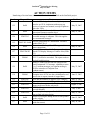
SunGuideSM Release 3.0 Design Review Meeting Minutes Date: May 2-3, 2007 Location: District 5 Headquarters - Deland Attendees: Trey Tillander, FDOT CO James Pol, FHWA, Steve Corbin, FDOT D4 Jennifer Heller, FDOT D5 Mike Smith, FDOT D5 George Gilhooley, FDOT D5 Edward Grant, FDOT D5 Joe Steward, FDOT D5 Jennifer Heller, FDOT D5 Brian Cole, FDOT D5 Nathan Ruckert, FDOT D5 Manny Fontan FDOT D6* John Easterling, FTE Adam Clauss, SwRI Robert Heller, SwRI Dedaimia Kozlovsky, SwRI Steve Dellenback, SwR*I Marge Kiolbassa, SwRI* Meredith Moczygemba, SwRI* Sam Slocum, SwRI* Brandon Meiners, SwRI* Glenn Regner, SwRI* Stephen Johns, SwRI* David Chang, PBS&J John Bonds, PBS&J Krista Small, PBS&J John Hope, PBS&J *: Video Conference Attendees Subject: Design Review for iFlorida components of SunGuideSM Release 3.0 Note: Agenda and slides for each agenda item are available from the project website at: http://sunguide.datasys.swri.edu Item #1 – Introductions and Opening Remarks • • • • Trey introduced the meeting Introductions performed Product process (waterfall) discussed Bonds inquired about missing requirements: Tillander deferred until he has had time to review Item #2 – High Level Overview – meeting objectives • Robert presented • Trey explained that what we are trying to do in this meeting: Any new requirements that come up will be captured, and if possible will be completed under the existing scope. If not, new requirements will be deferred to a later release. • John Bonds asked if the “SUB” requirements (SwRI derived) are also considered functional requirements. Robert Heller clarified that these are functional requirements, Page 1 of 11 SunGuideSM Design Review Meeting May 2-3, 2007 and that they are intended to clarify the “FEAT” requirements, and gave an example of how/why SwRI would define a “SUB” requirement. Item #3 – Variable Speed Limit Signs • • • • • • • • • • • • • Adam Clauss presented the slides Trey Tillander asked if there will be limits to what the minimum can be lowered and the maximum to which it can be raised. Additionally, there is a minimum speed limit for interstate highways within Florida. Heller described the functionality of the system as selecting one of two speeds based on traffic conditions; these are specified by individual sign (this functionality is as described to SwRI in Sept 2006 by Joe Schuerger of PBSJ) Is there a timeout for accepting the recommended change? Talk of a timeout for the recommendation for configuration. And a time limit between changing the recommendation. Jennifer Heller commented that as long as they can tell the difference from a DMS the icon is fine. Will there ever be a time when a speed limit is not displayed? No. There will be out of service, etc. Jennifer Heller confirmed that operators should not be allowed to manually post a speed limit. The operator can select speed proposed by the system. Need to formulate recommendations for the OI at the follow-up on the 25th. o This makes the third pop-up that can occur within the SunGuide system. The others are DMS spelling and DMS C2C permissions. o Bonds: Do these get tiled? SwRI is not sure. o Jennifer Heller: Currently there is a flashing window at the top of the screen that indicates there is a VSL recommendation. The operator can select this and then the VSL window comes up. This is a concern about how many pop-ups you can get and distract the operator. Bonds: If the operator does not accept the recommendation, when does the system make a new recommendation? Tillander: This indicates that the operator has made the decision not to use the VSL. Smith: So it should not make a new recommendation until “it recovers and then makes a new recommendation.” Chang: Who has the authority to approve a speed limit? D5 (Gilhooley) is looking into this. Central office is looking into this. Smith: Flash the VSL? Flash VSL on an overlay of the map? How do we get a VSL alert to the operator? A map feature that could notify the operator of alerts across the top of the map. Re-opened the VSL discussion at 4:25 after finishing other topics to further discuss what speed limits and configuration parameters are needed. Heller: Based on discussion in Deland on September, SwRI had designed for one normal and one alternate speed, and to operate each sign independently. George described the operation of the VSL system now: o Set more than two (default and slow) speeds. Currently a VSL supports 55, 50, 40 and 30 or it supports 50, 40 and 30. There are 22 VSLs, 6 are using 55 mph. Page 2 of 11 SunGuideSM Design Review Meeting May 2-3, 2007 • o The current system allows an administrator to define plans for VSLs and the VSLs to operate in groups. o Speed limit recommendations are based solely on a rolling 5 minute average of occupancy rates and also a predicted 5 minute occupancy rate o Increased occupancy rates can affect multiple VSLs, not just the VSL closest to the roadway link. o There may be multiple plans in operation at a single time, but they are guaranteed by the system not to conflict FDOT tried to provide a demonstration but the system was rebooting. FDOT provided the SUM for the VSL system via email after the meeting. Item #4 – American Dynamics CCTV Driver • • • Adam Clauss presented the slides Bonds: you can still get status? No status. Tillander: Is there any possibility of delivering this earlier than with 3.0? SwRI committed to looking into this. Item #5 – EH / SL Enhancements • Adam Clauss presented the slides Item #6 – Message Arbitration System (MAS) Modifications • • • • • Adam Clauss presented the slides Corbin: Merge only one sign at a time? Why cannot I merge all messages with a response plan with the travel time message? He likes the capability but the implementation of a sign at a time makes it hard for the operator to use. Corbin: What happens when the response plan message goes away? They automatically unmerge. Tillander: Release 3.1 plan for travel time enhancement. There is Amber Alert CONOPS out now. We need to develop additional requirements for Release 3.1 for the travel time to an accident. We need to develop requirements for adding incident to travel times. We need to develop requirements for adding Amber Alert to travel time. Hope: Can you use the DMS Group concept? No, the DMS Group concept is a GUI object, not a DMS or MAS concept. Item #7 – 511 • • • Dedaimia Kozlovsky presented the slides Bonds – how will the location of 511 icons be determined on the map? Use a telephone symbol. FHP CAD incidents not currently imported into SG. When will this available? 3.1? 3.x? Will be a priority, maybe 3.1. Page 3 of 11 SunGuideSM Design Review Meeting May 2-3, 2007 • • • • • • • • • • • • • • • • • John - Do not allow completion of a scenario without a complete set of messages (.wav files). NO --- just give popup when a scenario is attempting to go out and it does not have a file. This matches requirement. Tillander – why “minimum of 1000 .wav files” – D5 actually has 3100. Requirement was written that way, may be too low. SwRI – do not anticipate additional messages to be a problem. PBSJ: If there is a scenario and not a message, then we record a new message. If there is not a message for a scenario, then this is a configuration error. If you prohibit this case, then you are rewriting the requirements. So, we will leave this as is. Bonds: How do you address the limit of 60 second cutoff? With a timer. Jennifer Heller: Is 60 seconds a reasonable limit? Will check with operators to get their opinions. D-5 RTMC operations confirmed that 60 seconds was acceptable. Bonds: What about the problem with concatenation of two 60 second messages with a limit of 60 seconds for the concatenated message. Needs further investigation. Question from SwRI – are roadways more complex than a name? George - No. Question from SwRI - Are drive-time summaries, drive-time comparisons, and summary comparisons the same? George/Jennifer – Yes/no/sorta… maybe not in future???? Get LogicTree ICD to support it. (SLIDE 43) FEAT25.6.3 refers to “information.” What information is being reported in both directions of travel? FDOT will take this off-line. Subsequent discussions prior to lunch indicate that the travel times on the spokes from the rim analogy is not really what D5 needs. This will need work on both sides to resolve this. [DK: also determined that there should be a change to the formatting of Link Summary Reports to be directional – E/W would be different summaries] Tillander – incident association strategy, in order to properly associate incidents with 511 segments, the roadways all need to be named consistently.. Since this is done through drop down boxes and operators are not allowed to “free text” roadway names there is consistency in naming. Tillander: Is there a lower bound for a travel time segment? There is a minimum for each reporting segment. You have to enter a minimum time for the slots into which we put the wav files (see page 67). Slide 71: Remove “Enabled”. Jennifer Heller – Instead of enabling or disabling a 511 reporting segment through the admin GUI, FDOT would like this capability from the operator GUI. D5 no longer uses override messages. Instead they record the information in the summary and then turn off the TVT portion of the message. FDOT would like the ability to be able to record and save a “base” message for a 511 segment. Requirements forbid the reuse of a custom recorded message, but FDOT would like the ability to save a few custom recorded messages for reuse. On GUI mockups – has a date recorded – this should include a timestamp as well. Should also include filename of the message. Jennifer Heller: Recording of a new wav file should display the controls of play/stop/record Page 4 of 11 SunGuideSM Design Review Meeting May 2-3, 2007 • • • • • Corbin – Suggests tying the manually recorded incident message to the SunGuide incident so that when the incident gets edited or closed the operator is prompted to make the changes to the 511 system. Bonds: review the wave files is all audio – yes. SwRI needs to check the LogicTree ICD to see if the IVR system supports the drive time comparisons. FDOT concurred on the interpretation of Drive Time Summary Comparisons. There will be a follow up telecom on Monday May 7 to discuss this in more detail. Krista Small: can an operator delete a message that another operator recorded? Yes. Item #8 – Web Server • • • • • • • • • • • • • Robert Heller presented the slides Corbin - need to hover over an icon and get mouseover text (aka “camera”, “dms”). SwRI: Hover over gives details of event (same as D2 website). SwRI will determine what is required for ADA compliance. To save space on statewide, could put legend over the Gulf. Allow to minimize legend. Corbin: Icon hover-overs may open off the screen if icon close to the edge. Google provides way to specify where to open. David Ashton can assist if necessary. Tillander: Will the ‘locate an address’ function be part of our map? Yes, it is provided by Google. Based on our SwRI test site, could place under “Select Map Layers” on the left. SwRI test site: Statewide view needs to be expanded to include whole state. SwRI test site: Filter the Conditions/Incident/Construction list based on the checkboxes enabled on the map. The slides are based on the requirements SwRI received for the Web Server. However, based on the web technology SwRI has been directed to use, some of them will not apply. Corbin: asked how much of the eventual ATIS functionality should be on this site. Decision was made for cost purposes to use the SunGuide website with modifications for iFlorida. Trey: there is a new set of ADA compliance guidelines (or at least a new document name), need to make sure we use the latest set. Corbin: what methods for ADA compliance will be used – compared to various sample websites? Determined that SwRI will run the test to make sure final website is ADA compliant. Action item for CO to provide to SwRI for implementation. Bonds: asked when we decided on Google. Was decided during a conference call on April 24, 2007. Trey: question on Google maps – district 5 will need to register with Google to get a license agreement from Google and provide Google with the URL of the site. Action item assigned to District 5. Slide 88 (www.fl511.com) o Like – Same 6 tabs on top except travel time tool will be removed. Mike Smith asked when and why this was removed. In January, and because of cost. Page 5 of 11 SunGuideSM Design Review Meeting May 2-3, 2007 • • • • • • • • • • SwRI is looking into whether it can possibly be re-added, based on recent request from Mike Smith. o Not like Accuracy Slide 89 (District 2) o Like: SwRI is probably going to go with a similar method for the ADA compliant text – on side rather than at the bottom. o Not like: Shape of map (long and skinny) – should be closer to square. Amount of space used for links on the right-hand side of the front page. Links do not need to be on the front page. Slide 90 (SMART SunGuide) o Like: scrolling banner (user configurable). o Not like: non-tabbed approach Slide 92 (Other sites) o Like: Feature that allows user to find a location on the map. This is a Google maps feature. Google features (such as the locator) in the map legend. o Not Like: legends/overlay control on top of the map. Although might be ok if it can be minimized. Corbin: what screen resolution will the map be designed for? FDOT will apply for a waiver to use 1024x768 rather than 800x600. May need a clickable print version of the website to get the waiver. D5 to apply for a waiver. Corbin: asked if SwRI has information on the plain language act? It says that you cannot use acronyms on the website. Corbin will send to SwRI. Corbin: can SwRI support an enhancement to “download” a scrolling bar onto the user’s PC? Glenn showed a preview of the Google-maps-based website. o Trey: asked where the address locator would be. It will be added in the area to the upper-left where map layers are listed. o George: Is congestion? Speed/alarm thresholds across C2C color configurable? Yes. Is it based on speed alone, or on other factors? The website just bases color on whether or not the link is congested based on a whether or not SunGuide says it is classified as congested. Within SunGuide, the judgment of whether or not the roadway is congested take into account the speed limit on the link as well as current speed. Corbin: can web developer make sure mouse-over pop-ups are shown within the current open browser window (make sure will not go off edge of screen)? If this can be done with Google Maps SwRI will implement. Trey: will users be able to select different types of maps that Google provides? Yes. Trey: Will D5 be able to use their existing web server hardware? Yes, a blade of the web server has been set aside for this. Page 6 of 11 SunGuideSM Design Review Meeting May 2-3, 2007 • • • • • Trey: Joe provided statistics on 511 website hits - 56 million total web hits since the start of 511. This is not unique visitors (shows up as a hit when they change pages). Around 150,000 per month. Trey: Asked about last bullet on slide 95. Why are we not placing pop-up message when user click on the links indicated that another web page will be opened. SwRI made this decision based on space, but if links are to be on another page the text can be included. Mike: How would administrators edit the list of links on the “links” page. It will be configurable. What kind of editor will be used? A simple text editor (e.g. Notepad) will be used. Where would the banner be located? Glenn: do we need to take up this much real estate? Currently the banner scrolls across the box of the regular “Florida 511” header banner, so it should not take up any extra space. SwRI will investigate adding the travel time planner to the web site. Travel times (available via C2C) will be provided. Action item for SwRI. Item #9 – Operational Data Store • • • • • • • • • • • • Robert Heller presented the slides Bonds – is there any information on how much storage this information will take? Yes, the CFDW SDD has a detailed analysis of this. Bonds – some data comes from the SunGuide database, some from this ODS? Yes, but no single report requires information from both databases (so no joins between them). Trey: the Reporting subsystem will be reviewed next week; Trey requested that list of reports with data source identified for each report (summary was provided on page 98 of slides). Action item for SwRI. George – is Crystal the right choice for these reports? We initially had in mind an Oracle product to generate the reports, but after taking into consideration the SunGuide 3.0 reports and the existing 2.2 crystal reports, we chose to provide a common interface to all reports through Crystal. Bonds – should we capture the list of implemented reports in requirements? Tillander – No, just having a requirement that reads “15 reports” gives flexibility to add/change/remove reports as desired. George – What about CAD/DMS data? CAD is not in release 3.0. DMS and VSL will be there. Tillander – slide 107 depicts data going straight from ODS -> Browser, is that accurate? No – reporting subsystem will retrieve data, write the report PDF file to a separate location. URL for that file will be passed back to the browser. Smith: Where is information regarding Meteorlogix data? Not in release 3.0. This was removed to reduce cost. D5 is in the process of updating their current RWIS devices to acquire NTCIP devices. Are these report mockups actually from the CFDW SDD? Yes. We intend to replicate these very closely. When is cutoff for saying they want reports changed? Follow-up design review (Tillander and Dellenback). Page 7 of 11 SunGuideSM Design Review Meeting May 2-3, 2007 • • • • • • • • • • • • • • • Jennifer – have you seen any reports in these screenshots that look like they may be overly difficult? No. It would be useful to know if there are any ‘types’ you will never use (ex: data at more than yearly intervals). Useful for data partitioning purposes to improve performance. For graphs – do NOT need individual lane data. Already have this data in tabular format. Only go down to direction (EB versus WB, etc) George - Slide 116 – That stacked graph (top) does not make sense. Line graphs would make much more sense. Same for slide 115. SwRI will make changes to users’ preference. George/Jennifer - GENERAL RULE – use line graphs instead of stacked bar graphs. Slide 130 – need times as well for the 511 messages. Want to be able to relate travel times to incidents. Report needs to be redefined. SwRI will make changes. Trey: could SwRI show a slide with which reports are coming from which database? Heller: no, and not for next week, we’re not quite that far yet. Discussion about Crystal Reports o Currently there are strange features such as users being required to log in multiple times. This should not happen with the Crystal reports in SunGuide. o Mike Smith: Asked about efficiency/how quickly the reports will be generated? SwRI anticipates that the reports should be generated quickly since the ‘rollups’ to minutes, 15 minutes, etc. will be performed as the data comes in and stored in the ODS. Bonds: are there requirements for retrieval performance? No one remembers, but this is a concern. Mike Smith – Update on external, real-time, raw data feed (asked about at last meeting) for third-party users (media, etc.)? Some data, including travel times, is available through C2C (XML format), but not raw 20 second data. Raw 20-second data is also stored to CSV files. SwRI response: the C2C interface needs to be “enabled” so that C2C data is published, FDOT D5 would need to allow network access the web server running the C2C infrastructure so that 3rd parties could access. SwRI can assist under the SunGuide support effort. Hope: are error logs also purged after 90 days. Heller: Error logs are managed by an entirely separate component from the ODS. Gilhooley – Slide 118 - how to the detector stations get picked? User selects them. There will be a separate graph for each detector station. Jennifer Heller – Slide 118 - Please use more human-readable names or include more information, and be consistent throughout SunGuide. Labels like “Station 546” are not helpful. Heller: The labels will use the device names configured in SunGuide, and Joe has configured descriptive names, so there should be no problem. Corbin: using Crystal, can’t we allow the users to select the graph format? Trey: the concept was that SwRI would do X number of reports, and FDOT would make changes/additional reports from there (again for cost efficiency). Hope: Slide 126: Could “Positive Direction” and “Negative Direction” be changed to something like “Northbound” and “Southbound” appropriately. Heller: Yes. There was extensive discussion of the report depicted on Slide 126. o Heller provided an inaccurate description of the report. Page 8 of 11 SunGuideSM Design Review Meeting May 2-3, 2007 • • • • o FDOT wants the times in this “Travel Time Report” to be computed based on raw detector data, not capped or smoothed. o Dellenback: Footprints issue (#63?) – uncapped speed data is stored to the archive. o Corbin & Gilhooley would like to do another travel time computation for these reports. o Trey: requested that SwRI investigate level of effort to report uncapped travel times. o Hope: Slide 126: What time period is this reporting. Heller: current. Heller: came back to slide 126 at 10:48 and clarified that this report is a detector/link status report – what is the current speed, and based on that speed, what is the time to drive across the link. It has nothing to do with SunGuide travel times, and it is misnamed. So the report WILL use actual speeds, there is no issue. o Discussed detectors that only monitor one direction – the other direction should be blank/empty in this case. o Corbin: if this report is showing detectors, could the report also show what links (TvT links and/or 511 links) the detectors are in? o Corbin: do we want the report to be broken down by lane rather than detector? o Gilhooley: This report should show status (whether or not there is data) for BOTH I4 (loops) and other roads in central Florida (probe travel times from OOCEA). Intended for operator to quickly go in and see what data is available, what is and is not working right now. Should be sorted by road, so you see all of the I4 links, all of the SR50 links, etc. o Discussed whether to keep status column, what types of values to use in there, etc. Determined: Use SunGuide statuses (Error, Failed, Active, Out-of-Service) for TSS lniks Leave empty (blank) for OOCEA AVI links. Rename column to “detector status” o Discussed re-naming the report to be less misleading - something like “System Status Summary”. o D5 will provide additional feedback on desired report format before the follow-up meeting on the 22th. Corbin: slide 128: could this report show current suspect fields? Heller: this report is designed to show the status over the past 24 hours. Corbin is not asking to change the report, rather wondering if this information (what fields are not being reported) can be made accessible through SunGuide for diagnostic purposes. Bonds: Slide 130 - reports vary in units for reporting travel times – minutes, seconds, minutes and seconds – should we define a single format? SunGuide has the data to seconds, and can display it in whatever format is desired. FDOT stated travel times in these reports should be expressed in minutes and decimal fractions of minutes. Corbin: Slide 130 – could this report be used to associate incidents with 511 messages played? Discussed report – and it just shows all messages for a date. Jennifer & Page 9 of 11 SunGuideSM Design Review Meeting May 2-3, 2007 George requested a change to be able to select a specific time range, and show the .wav files that were playing for that range, the travel time that caused that to be selected, and the times that the .wav files were playing. So fields will be: o From o To o Date and time (range) o Calculated Travel Time (minutes to 2 decimal places) o Rounded Travel Time (5-minute increments) o Selected .wav file. • Slide 131: o Does this calculation know about how many lanes are on the roadway? Heller: no, this report just projects future traffic volume based on past volume(s) and a growth factor. For example, could project traffic volume on Mondays at 8:00 am in January based on last January, Mondays, 8:00 am and a growth factor. o Bonds: any interest in calculating the growth factor? Heller: no, the user will specify a growth factor. o Trey: planning already has analysis tools that calculate growth factors. Item #10 – Open Discussion • • • SwRI will send minutes out early next week. Tentatively scheduled follow-up design review video teleconference for May 22 8:30 to noon ET. We will attempt to cover the follow-up from both design reviews in this teleconference. Any comments on today’s discussion should be completed by May 18. Page 10 of 11 SunGuideSM Design Review Meeting May 2-3, 2007 ACTION ITEMS Numbering of Action Items is based on all action items identified on the SunGuide project. Number Responsible 122 SwRI 123 SwRI 124 FDOT D5 125 FDOT D5 / SwRI 126 SwRI 127 FDOT D4/D5 128 PBS&J 129 SwRI 130 PBS&J 131 132 FDOT D5 FDOT CO 133 FDOT D5 134 FDOT D5 135 FDOT D4 136 SwRI 137 SwRI Text Rework VSL design: based on multiple steps, need to see GUIs, implement without pop-up, review of current user manual, concept of plans to drive the VSLs. Examine schedule for early delivery of the American Dynamics camera driver Is to determine if the 60 second limit for a recorded message is adequate. This also applies to concatenated messages Provide clarification of “information” reference within FEAT25.6.3. Determine of the LogicTree ICD supports drive time comparisons Steve Corbin and Jennifer Heller to provide rulebased GUI display Message of Amber Alert (Slide 31) Slide 43 Requirement FEAT 25.5.22, FEAT 25.5.23, need to be reworded. The report needs to include both directions. Slide 55, SwRI will look into the option to turn on/off automated TvT message, capability to store 1 or 2 incident message( per segment message). Will be entered as a Footprint issue (enhancement). Need to create a requirement and compare to footprint issue #63 of raw data calculation for real travel time in report (instead of capped data). Who has the authority to approve VSL changes? Provide the most recent ADA guidelines to SwRI D5 will need to register with Google so that their maps can be used on the web server FDOT will request a waiver for the web site to exceed 800x600. Send the “plain language act” to SwRI for their use on final web page design. SwRI to investigate adding the travel time planner to the website. Provide FDOT with a list of ODS reports (along with data source) Page 11 of 11 Due Date May 23, 2007 May 23, 2007 May 23, 2007 May 23, 2007 June 15, 2007 May 23, 2007 May 23, 2007 August 1, 2007 July 1, 2007 May 23, 2007 June 15, 2007 May 30, 2007