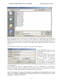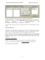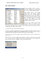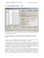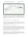
1
DANUR COMPUTERFLIGHT SYSTEMS
Flight Operation Center
FLIGHT OPERATION CENTER
Version 1.24
OPERATORS MANUAL
By Urs Wildermuth
Programming by Heinz Oetiker
-1-
DANUR COMPUTERFLIGHT SYSTEMS
Flight Operation Center
Flight Operation Center
Virtual Pilot’s Edition
User’s Manual
Introduction
Flight Operation Center is a new kind of flight planning software, that combines accurate
and realistic flight planning with a link to popular flight simulation programs, such as
Microsoft Flight Simulator 2004 and 2002. Amongst unique features of Flight Operation
Center you will find a lot of what you have been asking for a long time, but were never able to
get from any of the existing products within your budget.
Other than most flight planning products in the entertainment sector, Flight Operation Center
is a scaled back version of a future professional system, which, at a higher cost, is intended
for airline operations or to be used by real world pilots. The current Virtual Pilot’s version
offers almost all features of the Airline Pilot’s version apart from the updateable database and
some airline specific features such as ACARS link, SITA message management and advanced
scheduling options, while it includes other features not included in the professional package,
such as the Simulator Support.
•
•
•
•
•
•
Full Worldwide Navigation Database, including world-wide SID-STAR routes,
Airways, Waypoints, Navigational Aids, and many more features.
Flight Operation Center will accommodate any type of aircraft from small propeller
airplanes to the largest, ultra long range jet transport aircraft with full accuracy,
several different cruising modes, abnormal configurations and many other
possibilities.
The aircraft database included with Flight Operation Center contains some of the more
popular aircraft around, covering a wide spectrum from Boeing 747-400, MD11,
A320, A330, MD83 to smaller airplanes like the Socata Trinidad. The comprehensive
flight model editor allows you to enter any type of own airplane to the degree of
accuracy you require.
Flight Operation Center will let you handle your personal schedules or load predefined
schedule files of different airlines. This feature is extremely useful for virtual airline
operations, who wish to keep all of their flights up to date and generate flight plans
quickly and easily.
As another first in the entertainment field, Flight Operation Center offers full support
for airline specific features like ETOPS / EROPS, STOPS operations, special cruise
modes and many more you haven’t even heard of before reading this manual.
Amongst the entertainment features of the Virtual Pilot edition are direct creatable
ATC adventures for MS Flight Simulator, Flight Plans for EFIS 98, FS2000, ACSGPS
and many other FS featured addons. Via the Microsoft GPS Format, our plans can
easily be read into most FMC’s like the ones found in Dreamfleet’s 737, Pilot in
Command, and the Phoenix Series.
-2-
DANUR COMPUTERFLIGHT SYSTEMS
Flight Operation Center
In short: Flight Operation Center, Virtual Pilot’s Edition will offer you features and
possibilities never seen before in this market segment, for a competitive price. So, enjoy your
new- found freedoms and get to work!
A word of caution: Due to the exactness and elaborate flight planning possible with Flight
Operation Center, a in depth study of this manual is absolutely essential for success.
PLEASE take time to read though this manual, to do the examples written in here and to
get familiar with the product. It is your money spent!
WARNING: Flight Operation Center, Virtual Pilot’s Edition is NOT intended for real
aircraft operation. No flight plan created with Flight Operation Center shall ever be used in
any context for real world navigation or for any other purpose than private entertainment
using Flight Simulators. DANUR COMPUTER FLIGHT SYSTEMS will accept no liability
whatsoever resulting from the use of this software.
Copyrights:
Flight Operation Center is protected under international law. No copies of this software
must be made or distributed for any reason or purpose. DANUR COMPUTER FLIGHT
SYSTEMS grant you a non - exclusive licence to use the software on one computer at a
time. You may share results of your work, such as flight plans or aircraft data created
by yourself, with others, via any means you choose, including bulletin boards and the
Internet, however, this does not include any of the aircraft or navigational data included
in the program as such.
The navigational data in this product are licensed to you via European Aeronautical
Group UK Ltd. They must under no circumstance be used for real world navigation.
You are not allowed to use the data for any other purpose than creating flight plans and
other products using this edition of Flight Operation Center. The data includes some
unique structures and facilities that protect it against illegal use, and which would allow
us to identify such use easily within such products as scenery or other navigational
products.
Any violation of this copyright will be prosecuted with all the available means of the law.
Credits:
Product design:
Programming:
Database design:
Manual:
Aircraft data:
Heinz Oetiker and Urs Wildermuth
Heinz Oetiker , parts by Simon Hradecky
Heinz Oetiker
Urs Wildermuth
compiled from different sources by Urs Wildermuth
MS Flight Simulator Aircraft by Heinz Oetiker.
Weather and NAT Server: Simon Hradecky, Nomissoft GmbH.
Navigational data:
Virtual Navigation Systems Limited, adapted for use with
Flight Operation Center by Heinz Oetiker.
Webshop and Licensing: Simon Hradecky, Nomissoft GmbH.
NAT PLOT:
Contributed by Bob Raemer. We sincerely thank Bob for his
adaptation of NATPLOT to our needs and for his kind
consent to include it with our product.
-3-
DANUR COMPUTERFLIGHT SYSTEMS
Flight Operation Center
Pricing and conditions of use:
The current price range for Flight Operation Center is as follows:
All Prices in Euros and excluding VAT:
Virtual Airline Edition
including a free 3 month subscription to the weather server
Euro 12.50 +VAT
Virtual Pilot’s Edition
including a free 3 month subscription to the weather server
Euro 45.-- +VAT
Virtual Pilot’s Edition
One Year Promotion
including a 12 month subscription to the weather server
Euro 49.99 +VAT
Upgrade Virtual Airline Edition to Virtual Pilot Edition
Including a 12 month subscription to the weather server.
Euro 40.— + VAT
VAT is applicable to users within the European Union. All other users will not be
charged VAT.
Subscription to the Weather Server:
Flight Operation Center features one of the most complete weather servers world wide. The
data available include:
-
Worldwide METAR, TAF 9 hr and TAF 18 hour
Worldwide Inflight Wind Prognostics up to 36 hours ahead of time.
OTS Track Download for North Atlantic Tracks and Pacific Tracks.
With your product, you receive a 3 month subscription for the weather server, or, with the
Promotional offer a 1 year subscription. Shortly before expiring, FOC will remind you to
renew your subscription, which you can do via the FOC Website http://www.danur.com
1 year subscription to the Weather Server
Euro 10.-- + VAT
Registration with the Server.
After you downloaded the product, you need to proceed to the FOC Website
(http://www.danur.com). You will then need to register your copy of FOC. Follow the
instructions on the Website to register. A credit card is required for this operation.
Above indicated prices are subject to change without notice. Refer to the website for up
to date information.
-4-
DANUR COMPUTERFLIGHT SYSTEMS
Flight Operation Center
Getting started!
Installing Flight Operation Center on your PC.
Download the software from the website and store it in a temporary file. Then proceed to the
web shop and register the software as described above. Remember the user name and
password, as this is your registration key.
To install Flight Operation Center on your PC, launch the downloaded program file by double
clicking on it.
Setup will initialise and you will see the intro screen. You have the choice to do a default
installation or to choose a custom installation, which will give you the possibility to select the
directory into which to install Flight Operation Center.
If there are no binding reasons, do proceed with the default install. This will install Flight
Operation Center into the default folder, which is C:\Program Files\Flight Operation Center.
Choosing the default installation path will also help you to later install upgrades to the product
as they become available. They all assume this default path, and you will have to specify a
different one over and over again.
Also during the installation process, an option to see a Read.Me file comes up. Print the read
me file and add it to this manual! Failure to do so will almost certainly mean that you are
missing on the latest updates which are included in the product but you missed out as they got
introduced after this manual went to print.
During the first start up, you might see a message concerning printer and fonts. If you do,
please open the preferences menu and set your printer and font, the font being COURIR. This
will fix this window appearing .
First steps.
After you have installed Flight Operation Center , of course you will be eager to try it. And so
you shall. The following steps will allow you to create a sample flight plan very quickly.
Start Flight Operation Center from the icon that you can find on your desktop. After a start up
screen, you will be presented with the main screen. On the top, you will see a title “Flight
Operation Center 2003 [TRIAL]. This indicates, you have not yet synchronized with the
server.
Synchronizing your edition.
Open the WEATHER Menu and select REQUEST Weather Data. On the screen that appears,
enter your user name and password, if you want to permanently safe your password, check the
corresponding checkbox. You can save this data by selecting “File” and “Save Configuration
File”. Now, click on the “Connect” icon (the 2 PC’s on the button), make sure you have an
open internet connection. FOC now connects to the server and transmits your data. It then
downloads the user information data you entered when registering plus all the weather data.
Once you have finished, leave FOC and restart it. You should now see [your register level]
instead of the [TRIAL] level.
-5-
DANUR COMPUTERFLIGHT SYSTEMS
Flight Operation Center
Producing your first flight plan.
On the list on the left hand side, you are presented with a list of flights, which are available at
this time. Select one of the example flights represented there.
You will note the departure and destination airports pop up in the “Active Flight” window top
right. Also, in the Alternate window below it, ALT 1 and ALT 2 are filled in. The aircraft
type used in the flight is marked in the blue status bar on top. If you want to change it, click
on the Aircraft option on the menu bar and select another plane or registration.
Now, look at the route window. You will see 2 routes displayed in the route box. Click on
both of them to mark them Now click on the big “Calculate” button. The output window
appears and you will be able to follow the calculation process as it develops. Once it
completes, you will see what is known as a “Citypair comparison”. Both selected routes are
displayed in a short form, together with fuel burn, weights and, most importantly, flight time.
Based on this calculation, you can now select the quickest route. You can print out this route
by using the Print button on the output screen.
Close the view window and go back to the route window. Click now on the fastest route only,
so that one route is marked now. Click “Calculate” again to calculate the Operational Flight
Plan. Now, you can see the Operational flight plan. On the top right corner, you see the
sequence number and a Release—remark. If you now click on “Release” and then the Print
button , the release remark will change to Release01 and the plan is printed on your printer.
If you want to create output to your simulator now, close the output window and click on the
“Go” option on the menu bar. Select the FS Utility. A window opens where you can create
different outputs to Microsoft Flight Simulator. For Microsoft Flight Simulator you can create
Adventures, GPS flight plans, FMS routes, ACS GPS routes and EFIS routes at the time of
writing.
If you want to send the plan to anyone, open the Message option on the menu bar. In this
edition of the program, you can e-mail any of the output to your friends.
Now you can experiment around with these flights, choose different airplanes or routes. Get
used to the inputs described in this chapter. Then, once you have done that, it is time to go on.
-6-
DANUR COMPUTERFLIGHT SYSTEMS
Flight Operation Center
Program Operating Manual
Starting the program.
Click on the START Button. Choose Programs. Choose Flight Operation Center. You are
presented with a choice of options.
Deinstall will uninstall FOC from your machine.
FOC –xxx- High Res Starts FOC in 1024x798 mode
FOC –xxx –Low Res Starts FOC in 800x600 mode
FOC Aircraft Editor starts the aircraft editing tool
FOC Data Installer starts the data update tool
FOC Nav Data Editor starts a tool to edit navigation data
FOC Router starts the route editing tool
FOC to FS utility starts the conversion tool to FS adventures and flight
plans.
NAT PLOT starts a freeware program by Bob Raemer, that allows displaying and printing of
FOC routes on a world map. See the NATPLOT documentation at the end of this manual.
Request Weather Data will start the weather import tool, which is also used for registration
and updating FOC.
The xxx is replaced in your version by the actual license you have. For most users, xxx is
replaced by the letters SIM.
-7-
DANUR COMPUTERFLIGHT SYSTEMS
Flight Operation Center
Main Screen
The main screen of Flight Operation Center is from where you will execute most of your
work. The blue status bar on top displays the current version, the license used, the current
Navigational Data Cycle number and, once it is selected, the active flight. It is split in several
sections:
The Menu Bar:
Allows you to select the different menu options.
The Button Bar:
Allows you to directly access several shortcut options.
Sections:
The screen is split in sections to organize the various operations.
Active Flight:
Select, display and modify the active flight
Alternates:
Select, display and modify alternate airports and options.
FL and Cruise:
Modify the profile and cruise regime settings.
Fuel Calculation:
Select, display and modify options for fuel regimes.
Weight/Balance:
Modify weight figures.
Route and Comparison Calculations: Route selection and calculation section.
The different sections and the use of the fields are explained in detail below.
The picture above and the following chapters refer to the low resolution (800x600) version of
FOC. The high resolution version is identical, but has some more space on the desktop.
-8-
DANUR COMPUTERFLIGHT SYSTEMS
Flight Operation Center
MENU BAR AND TOOLBAR
The menu bar contains the following Menus:
Flight Menu : Contains all options regarding flights and schedules.
Opens a sequence file
Opens a segment file
Creates a backup of segment files and optionally deletes
old files
Performs scheduled or company dayloads
Loads the complete Schedule without criteria
Opens the Schedule Editor
Ends the program.
Preferences Menu Allows setting of printer and font preferences and input of default
dispatcher and pilot names.
Allows setting of the printer preferences.
Switches between JAR OPS RR20 or normal route reserve.
Defines default names for pilot and dispatcher.
Limits wind speed to 99 kt for users of Precision Simulator.
GO! Menu
Calls up the FOC Router
Calls up the STOPS/EROPS Scenario Editor
Deletes NATPLOT flights and routes
Calls up the various simulator links.
See the relevant chapter in FOC Manual .
-9-
DANUR COMPUTERFLIGHT SYSTEMS
Flight Operation Center
COMMON DATA
Calls up the various data tools such as Aircraft Editor, Airline
Editor and the navigation data import utility. Remark: After
changes in Aircraft- or Airline data always reset FOC Lists in
this menu!
Weather
Allows access to various weather options:
Calls up the Weather Request Utility - the Upperwinds Data Editor - the User Wind Dataset
Editor and opens the file selector to give the choice of (UWX-/METAR-)files to delete.
See chapter Weather in the Manual for more information.
MESSAGES calls up Messaging tools, such as e-mail, ACARS and other datalinks. See the
relevant chapter chapter in FOC Manual.
The Toolbar :
Open Sequence File : Opens a previously calculated flight for further work.
Open Release File : Opens a previously released flight for further work.
Back Up Segment Data : Creates a backup of segment files and optionally deletes old files.
- 10 -
DANUR COMPUTERFLIGHT SYSTEMS
Flight Operation Center
Scheduled and Company Dayload. Performs the dayload of flights according to date or to
company. For more information on the dayload function please see the explanation of it in the
scheduler section and in the "Managing Schedule Data" section below.
Select this flight : Confirms a selected flight for working input.
Utility Launch Buttons.
These 5 buttons can be used to start FOC's data management utilities. They are from left to
right:
Scheduler : Starts the schedule management tool.
Router : Starts the router.
Aircraft Editor : Starts the aircraft editor.
Import / Export : Starts the import/export utility for FOC.
FS Utility : Starts the Flight Simulator Connection Utility.
Calls up the Weather Request Utility - the Upper-winds Data Editor - the User Wind Dataset
Editor.
These buttons define the different planning methods that can be used for calculating flight
plans. They are from left to right:
EROPS / Stops Scenario Editor : Calls up the EROPS/STOPS scenario editor.
PBR Planning : Activates the Planning Based on Reclearance option.
Inflight Replanning : Activates the Inflight Replanning option.
Normal Planning : Cancels PBR and Inflight Planning options
Show Output Window : Calls the Output Window.
Calls up the Email Tool.
EXIT FOC The Checkmark Button closes FOC.
- 11 -
DANUR COMPUTERFLIGHT SYSTEMS
Flight Operation Center
ACTIVE FLIGHT SECTION
The Active Flight section
is the place you select the
flight you wish to work
with from a list. If the
flight you are looking for
is displayed on the list,
select it by clicking on the
flight. If it is not, you
need to create it first,
using the schedule tool or
you can do a once only
flight by altering the
details in the various lists.
The data in this section are:
Company:
The operating carrier of the active flight. To appear in this window, the airline
company must first be defined using the airline editor. Default airline is a
fictional company called Simline. Displayed are the ICAO 3 letter code, in this
case SML, the 2 letter IATA code, in this case S9, and the name of the
company, in this case Simline.
Date:
Date of flight. This window uses the US system of date, year first, followed by
month and day.
Type:
The aircraft type used for the flight. Changing the aircraft type will initially
change the operating carrier, as each plane is matched to a company. You may
overwrite the carrier afterwards, if the plane is operating a sector from another
airline.
Fleet:
Every aircraft may have several different registrations, to cover fleets of the
same type. Choose the appropriate registration from the list.
Flight Nr:
The flight number of the flight you wish to operate. Only the numbers are
required, the three letter code is added automatically via the company code.
Departure:
The departure airport is displayed by it’s ICAO code.
Destination: The destination airport is displayed by it’s ICAO code.
EET:
Approximate flight time. This time is calculated from the following two fields.
STD:
Scheduled Time of Departure. This is the time the aircraft leaves the gate.
STA:
Scheduled Time of Arrival: This is the time the aircraft is expected at the gate.
Flight List:
Displays all available flights in a schedule.
- 12 -
DANUR COMPUTERFLIGHT SYSTEMS
Time OFF
Time In
Scheduled
Flight Operation Center
Taxi Time on departure
Taxi Time on arrival.
Type of flight for use in the ICAO Flight Plan. Default type is “S” for
Scheduled Service. Other valid types include “N” for Non Scheduled Service,
G for General Aviation.
Once you have clicked on the flight, it's details appear in the windows above. You see the
airline, aircraft type and registration, flight number, approximate flight time (EET),
Scheduled Time of Departure (STD), Scheduled Time of Arrival (STA). Some of these
parameters may be modified, which is useful if you have a change in flight number or a
schedule change that is only used once for this specific flight. As a rule however, the aircraft
type and registration, which is not normally going to be the same in two consecutive days, has
to be modified in order to reflect today's flight.
If you wish to calculate a flight without keeping it’s details, you can create it by inserting all
the necessary information into the respective windows. First choose an airline, then the date
of flight, Select the aircraft type from the list window and choose the actual aircraft from the
fleet list. Now, enter details for departure, arrival and schedule of your flight. Once you have
all data, press “Flight Select”. This flight is now active until another flight is chosen. Caution:
Once you choose another flight, you can not bring back your flight unless you have already
calculated a flight plan.
How to change aircraft and registration.
If you need to change the aircraft type, click on the type list window. The airplanes available
will be displayed. Now choose the corresponding plane. You can only use planes which are
available for the airline in the schedule. Then change the registration by clicking on the Fleet
list. All registration for the chosen airplane are displayed here.
The Button FLIGHT SELECT.
You may select between all available Items, even change Departure or Destination of your
Flight. To activate this choice, you have to select it as today's flight by clicking FLIGHT
SELECT Button.
ALTERNATE AIRPORTS AND ROUTES.
In the Alternate section
you can enter the various
alternate airports to for
your flight. To enter an
alternate airport click on
the list to the left (e.g. on
ALT1) and then fill in the
respective alternate. Once
you have finished, the
alternate appears on the
window in the middle,
together with a distance.
- 13 -
DANUR COMPUTERFLIGHT SYSTEMS
Flight Operation Center
The fuel and time columns are only available after calculation.
You can specify two alternates to be used in the fuel calculation, two additional alternates for
which only fuel and time will be calculated and which will be displayed on the flightplan, and
you may specify a take off alternate, which is needed in case that the departure weather is
below minima for a return to the departure airport.
There are several different calculation modes available for alternate airports. The default
method is to use one alternate, that is alternate 1. If 1st only is selected, that is what happens.
You may choose to use the 2nd alternate instead, in which case the 2nd only checkmark
should be checked. You may further specify to use the higher of 1 and 2 by checking the
Higher checkmark. And you may choose to go via alternate 1 to alternate 2 using the 2nd via
1st checkmark. Finally, you may choose to not have an alternate airport at all, as it is possible
e.g. within JAR operations, you can specify that by checking the No Alt Fuel checkmark.
There are several different ways that alternate fuel and time are calculated. Flight Operation
Center 2000 supports alternate routes (see router part). If you select an alternate for which
alternate routes from the destination exist, they will be used. If no alternate route exists, a
great circle distance will be calculated and augmented by minimum 20 NM or otherwise 10%
of the distance, whichever is higher. In this case, a warning message will be displayed on the
flight plan.
How to set up and deal with alternate routes is described in the chapter about the Route
Generator.
FLIGHT-PROFILE: FL AND CRUISE SECTION.
This section is used to modify the calculated flight
level and to allow selection of user defined altitude
profiles. If the Profile checkbox is blank, the
program will itself determine the optimum flight
profile along the flight using the aircraft
performance data. If, for whatever reason, you wish
to modify those choices, you may do so by entering
your own profile in the profile window or by
entering a cruising level for the whole flight in the
FL selection window above. The maximum
attainable level is indicated in blue in the grey
window next to the altitude window.
Below the FL Selection section, you may choose the
desired cruise mode for your flight. Many airplanes
have different power regimes for the flight, some of
them high speed, long range or normal cruise. The default mode is displayed in the list
window upon loading of the flight. You can change it by opening the list next to the displayed
mode and selecting another mode if it exists.
- 14 -
DANUR COMPUTERFLIGHT SYSTEMS
Flight Operation Center
FUEL CALCULATION SECTION
Fuel calculation can be modified extensively
using the section to the left. Using the different
modes of fuelling and adding fuel reserves allows
to cater for almost all fuelling needs and
conditions. On the top, the maximum load the plane
can carry is indicated in blue. Next to it, the actual
calculated fuel appears after flight plan calculation.
Default fuelling mode is Minimum Required Fuel.
This mode will give you the minimum required for
the flight. Economic fuelling will add as much fuel
as possible, taking into account maximum structural
weights of the airplane and an allowance for weight
deviations. This is useful if e.g. the fuel price in one
destination is significantly higher than on the
departure station, so that fuel for the subsequent legs
should be carried. Remaining fuel will allow you to
specify the amount of fuel you still wish to have on
board on landing at the destination. Again, this
mode is intended to cater for subsequent legs, and is
particularly helpful if throughtankage is to be
planned. Remaining fuel will be reduced when
payload problems are experienced. In this case, a
warning is displayed. Actual fuel allows entry of a
given quantity of fuel, used often after aircraft changes when the fuel on board is higher than
the actually needed fuel. If the fuel entered here is lower than the required fuel, required fuel
will be displayed along with a warning. If the fuel quantity is too large to allow transport of
all load, the ZFW will be lowered and a warning displayed.
The following options allow for additional fuel to be carried for various reasons such as
weather or traffic situation. They will be incorporated in the minimum required fuel for the
flight. Whenever there is a quantity and time window, only one must be filled in, the other
will adjust automatically. That means, if you give a fixed quantity, you will see the time this
gains, if you give a time, fuel is calculated.
Company Fuel is used to add fuel for special procedures, air traffic delays and other known
factors. It is calculated using an unfavourable holding condition.
Holding Fuel is used to add fuel reserves for anticipated holding patterns when arriving at
busy airports. Some operators compulsory carry holding fuel, others don't, that is why it is
selectable. Holding fuel is calculated of the holding table from the aircraft file.
Taxi Fuel is the fuel used to taxi from the parking stand to the runway. It is used in almost all
fuel calculations for planes bigger than very small propeller planes, therefore it is selected on
per default.
Bias Rise allows modification of the fuel bias or performance factor. The standard factor is
1000, meaning 100% of book values. The bias allows adjustments to performance
- 15 -
DANUR COMPUTERFLIGHT SYSTEMS
Flight Operation Center
deficiencies of aircraft which are known to use more fuel than it is written in the performance
tables. A Bias of 1040 means e.g. that the aircraft uses 4 % more fuel than book values. The
Bias Rise feature allows to manually rise (NOT diminish) the bias to allow for special
conditions en route that require adjustment. Minimum Fuel Bias is always 1000, there is no
way of reducing bias.
Note: Fuel Bias is a very useful tool to deal with flight simulator airplanes. The performance
of these planes is hardly ever accurate enough to match book values. After a few flights,
which should be of different duration, you can note an average deviation in % to the values
your flight plan indicates versus the flown ones. Now you can simply adjust the Bias to reflect
those deviations.
Fuel Density is used to limit the weight carrying tank capacity. Fuel expands with
temperature so in hotter areas the density can deviate from the standard of 0.78 kg/ltr of fuel.
ROUTE AND COMPARISON CALCULATIONS
This section is used to specify the
calculation parameters. In the center
right, all applicable routes are
displayed. Marking one of them will
produce a flightplan on that route.
Marking more than one will produce
a comparison for all the routes, so
you can determine the fastest route
and the difference between routes.
The Create flightplan for fastest route
option will allow you to create a
plan for the fastest route at the same
time you do the comparison.
FOC supports normal and planning
based on reclearance. If you select
PBR planning, enter the PBR
alternate and the decision point in the
respective fields and check the mark
on.
FOC 2003 supports INFLIGHT
planning. This option is activated by
pressing the INFLIGHT button on
the bottom left. Enter the airport, and actual waypoint, flight-level, fuel on board (and
optionally actual GWT) in the respective fields and check the mark on.
FOC 2003 also supports ETOPS and STOPS planning. You activate that option by pressing
the Stops /Erops button on the bottom left. A menu pops up, where you have to declare the
ETOPS scenario using the ETOPS menu option.(See also chapter ETOPS)
Wind data from the Internet can be used to generate accurate flight plans. To activate a
previously downloaded winds aloft file, check the Active UWX option in this window. To
activate a previously defined User Set of winds aloft, check the Alias UWX option. If you
- 16 -
DANUR COMPUTERFLIGHT SYSTEMS
Flight Operation Center
wish to use a fixed component, check the Fix WC [+/-] Option and manually enter an over all
wind component for the flight. To enter a head wind, enter a negative number in the field right
of the checkbox. To enter a tailwind, enter a positive number. Wind speeds are expressed in
knots.
For details on how to connect to the Internet and download our weather data and how to
generate User Set of winds, please refer to the appropriate chapter in manual.
Start a planning calculation with the Calculation button. The empty Output Window will
appear and, after a short time, the results of the calculation. (See chapter Output Window in
manual).
The calculation of minimal requested fuel use to cause a multi pass calculation process.
According to calculated GWT, cruise level and upper wind values the number of passes may
rise up to max. 30. If so the calculation entered in a never ending loop, because no fuelage
ending with AD-fuel value < 1 could be found. In those cases you are told to try manually,
setting Actual Fuel value and recalculate in this mode!
THE INFLIGHT CALCULATION
FOC offers you the possibility to recalculate a flight plan in flight at any position. To do so,
you need your actual position, effective zero fuel weight at departure, fuel on board over that
position and your altitude.
If you wish to do a INFLIGHT planning:
Clicking INFLIGHT Button will open the INFLIGHT planning Window.
Enter the INFLIGHT alternate, Actual Flight Level, Actual Fuel and the decision point in the
- 17 -
DANUR COMPUTERFLIGHT SYSTEMS
Flight Operation Center
respective fields. (ZWF EFF is optional, if left empty, the ZFW indicated in the weight and
balance section will apply). Click OK! and calculate..
THE PBR CALCULATION
FOC gives you the possibility to a planning based on reclearance. This procedure is also
known as Decision Point Planning (DPP) in JAR Ops. If you wish to do a PBR planning:
Clicking PBR Button will open the PBR planning Window.
Enter the PBR alternate and the decision point in the respective fields and check the mark on.
- 18 -
DANUR COMPUTERFLIGHT SYSTEMS
Flight Operation Center
STOPS - ETOPS – EROPS
The STOPS/EROPS Button will bring up
the scenario window for Intermediate
Aerodromes and Extended Range
Operation under JAR OPS 2. Using the
input screen, you will be able to specify
which intermediate airports you wish to
use for the active flight, whether they are
used as intermediates or EROPS
alternates.
In case of a highlighted route, Departure
and Destination airports are automatically
displayed in the scenario window. To add a
new intermediate airport, use the
corresponding option. You may now
specify the new airport.
Once all airports used have been
determined, use the check boxes to
determine how the airports are used. The
STOPS checkmark will generate a equal
time point between 2 airports and will
check, if the 1 hour range is exceeded. The EROPS checkmark will create an EROPS Entry
Point (EEP), Equal Time Point (ETP) and an EROPS Exit point (EEX) between the selected
airports and check whether the EROPS range is exceeded.
Please note that this option is only available, if the aircraft used has been set up as a
STOPS/EROPS aircraft according JAR OPS.
You may open or save any scenarios by clicking the OPEN SCN or SAVE SCN button. It is
recommended to save the scenarios according to the route number they are valid for. (e.g. if a
scenario is valid for route number AAAADDDD.001, save the scenario also with extension
001. That way, you will find easier access to your scenarios.
On top of the list there is a special button SCENARIOS for quick access to the available
scenarios related to the actual flight.
Refer to the ETOPS / EROPS section in the flight planning chapters for more information on
how to use this feature.
- 19 -
DANUR COMPUTERFLIGHT SYSTEMS
Flight Operation Center
WEATHER - SECTION
THE UPPER WINDS and METAR DATA REQUEST:
FOC offers import of NOAA Upper Winds and METAR/TAF database access. Normally,
these wind files are huge data volumes of about 1GB per day, so we needed to convert them
into a more useful format for our applications. However, this costs us a lot of money in terms
that we have to download huge amounts of data and then have the web-space available to
offer you the downloads. Our resources as a small developer are limited, so we cannot offer
this service for free. You can subscribe to this service for a small fee by logging onto the
Nomissoft Website (www.nomissoft.com) and follow the links to the weather server.
What you get tough is worth the money. With every download you receive full world wide
upper wind data for the next 36 hours, so, practically, you need to do this at the maximum 2
times a day, while in FS2002 you need to update your weather regularly to keep in touch.
Also, it is not necessary to stay online for upper winds, as you have the next 36 hours on your
hard-drive. METAR and TAF data are a free addition to this, as we do not find the coverage
yet fully satisfactory. Also, TAF and METAR’s need to be kept current, so you would
theoretically need a continuous online connection. Again, that is not what we want. We are
looking into getting better information on this and will then include METARs and TAFs in
our services.
The UWX- and METAR Data are available at the NOMISSOFT Weather-Server and can be
downloaded with this tool. Likewise, OTS North Atlantic and Pacific Tracks can be accessed.
At a later stage, this tool is also prepared to deal with Navdata Updates.
Insert user name and password first. Tip: Save Data in Configuration File (Menu FILE).
Check/uncheck METAR, Short TAF and Long TAF, as well as the UWX options. If you
check UWX RANGE, the whole time-range of available upperwinds on the server will be
downloaded and the ZULU time actually in performance is indicated in ZULU start add list.
If you check Selected UWX, only the highlighted ZULU time will be downloaded.
- 20 -
DANUR COMPUTERFLIGHT SYSTEMS
Flight Operation Center
Apply Server Time: This feature allows the setting of your computer clock remotely with the
atomic clock driven server time. Whenever a connection with the server is established, your
computer clock will be adjusted to server time.
Make sure you have a valid connection established. Normally, your connection will establish
itself by ringing your ISP using your standard Winsock, however, if that does not happen, dial
up manually, or start Internet explorer in the background and make sure your connection is
up.
Once you have finished with the setup of preferences click on download button to proceed
the jobs.First the tool gets the servers time range and the customized download can begin.
Watch the progress indicated in the status label.
All data are stored in files in the FOC folders [Weather/UWX] and [Weather/METAR].
Filename conventions: YYYYMMDD.ZZC where YYYY=year, MM=month, DD=day,
ZZ=Zulutime, and for C: U=UWX file, M=Metar file, S=Short TAF file and L=Long TAF
file.
Do not forget to close the internet connection at the end...!
Scheduled Download.
Those of you who have a constant high speed internet connection may want to use a schedule
to download weather data to automatically keep the system current.
To set a schedule, open the EDIT Schedule button. The following window appears:
You now can define, at what times in UTC you want to download which data. The “Never”
option will block this particular set from downloading, AUTO will download according to the
server schedule, which includes all of the below dates. If you want to reduce the amount of
data that is being downloaded, apply the times when you wish downloads to occur.
You may create different schedules for standard, home, workplace, according to your needs.
To activate a scheduled download, you have to click the green checkmark “Scheduled
Download” on the main requester window. While this option is active, DO NOT CLOSE the
Request Utility, but you can minimize it if you want. If you close the utility, the reception will
stop.
- 21 -
DANUR COMPUTERFLIGHT SYSTEMS
Flight Operation Center
Please keep in mind that the scheduler needs an open internet connection all the time.
The Weather Window
This window allows you to easily retrieve your flight weather and to manage lists of stations
you need often.
Retrieving Messages
To retrieve messages, type the 4 letter indicator of the airport you are looking for into the
input line. Check the type of messages you want to check and press Enter. The messages will
appear in the display window to the left. To retrieve several airports, first check the marks and
then type each indicator followed by Enter.
Retrieving Messages relevant to the active flight
To retrieve the messages for all you destinations, alternates and departure aerodrome, press
the Airport button. A valid calculation must be present for this option to work.
Print Messages
To print out messages, click the Print button.
Airport Sets
The Set Editor option gives you the possibility to save lists of airports that are often used.
Enter the Set Editor, add the airports you wish to enter in the list and save it. It will appear in
the set window to the right. Clicking it will produce all the airports in question and display the
selected messages in the display window.
DFCS Weatherstation
This is a new product of Danur Computerflight Systems, which allows more elaborate
weather functions independent but also in cooperation with FOC. Check www.danur.com.
- 22 -
DANUR COMPUTERFLIGHT SYSTEMS
Flight Operation Center
UPPER WINDS EDITOR :
Not available in current editions.
In the upper winds editor window you have the option to create, open and save upper wind data files.
The
file names ending *.*U indicate downloded files. For use in this editor copy them
using *.??Z at the end of the file name! This utility gives you access to whole grib grid
wind data in order to edit them manually. This should be attempted only in
emergencies or in the event of failure of the GRIB server.
- 23 -
DANUR COMPUTERFLIGHT SYSTEMS
Flight Operation Center
THE USER'S WIND SET :
This Window can create, open and save UWX- and METAR sets for use asAlias. If you keep
wind data files on your harddisk, you have the option to calculate with old wind data. To
create such a set select Item by clicking on the related option button and select the file
connected in the list. Move by clicking > button.
What do you need this for? Well, let’s say you downloaded a particularly nasty weather set
for FS and want to reuse it again. Of course, for this you need the winds that were THEN
actual. So, don’t forget to save those winds
- 24 -
DANUR COMPUTERFLIGHT SYSTEMS
Flight Operation Center
THE OUTPUT WINDOW
This window appears after each calculation of a flight plan. Its purpose is to show the various
output formats, select in between them and operates on the output files.
The output window contains the following elements:
The menu bar
The button bar
The display window
The route window
Operating buttons.
The Menu Bar:
The menu bar offers three options:
FILE : Allows opening of segment and sequence files.
Preferences Menu : Allows setting of printer and font preferences and input of default
dispatcher and pilot names.
Output Allows saving and printing of all OFP lists at once.
MESSAGES : Opens the Email Tool with actual List.
The Button Bar:
- 25 -
DANUR COMPUTERFLIGHT SYSTEMS
Flight Operation Center
The button bar allows direct accessing of the various functions in the output window.
Map detail selection : Switches on and off Airports, VOR's, NDB's, Waypoints and the grid
in the map display.
toggles between text and map display.
The + / - buttons zoom the map in and out.
show the various output forms.
The functions are from left to right:
Show short flight plan : Shows an abbreviated flight plan form.
Operational Flight Plan : Shows the full length OFP.
Stops / Erops : Shows the Stops/Erops calculation
ATC Flight Plan : Shows the ATC flight plan.
Enroute Weather : Allows access to the weather database.
Operates on the shown plan. The functions are:
Releases the active flight plan.
Prints what is shown in the display window.
Files the plan that is shown in the display window.
Opens the Email Tool with actual displayed product.
Exits the output window.
- 26 -
DANUR COMPUTERFLIGHT SYSTEMS
Flight Operation Center
The display window.
The display window shows the different flight plan forms available in FOC, as well as a route
map. The different formats are toggled via the button bar.
The following forms are available:
· Short Plan shows a condensed, single sheet plan containing all important edge data Of a
flight.
· Operational Flight Plan shows the full length operational flight plan (OFP).
· Stops/Erops calculation according to JAR OPS.
· ATC Flight Plan shows a standard ICAO type Air Traffic Control flight plan.
A map display can be toggled using the map/text button on the button bar or with the map
button at the lower right of the route window. The map display shows a plan view of the flight
plan. To center the map, click on any waypoint on the route window to the right, the map will
center on that point. CAUTION: The map requires a lot of resources and can therefore load
pretty slowly.
Various Navigation Data can be superimposed on the map using the button bar. There is an
option to show airports, VOR's, NDB's, waypoints and a lat/lon grid.
Flights that include a STOPS/EROPS calculation will also be shown with the relevant
intermediate aerodromes and the relevant waypoints en route. See chapter STOPS/EROPS in
manual for further information.
Calculation Warnings and Notes
The route calculation may cause fuel- or weight values out of the range of the selected
aircraft. Related warnings as well as flight related notes are shown in the flightplan.
The following Notes may appear in the Flightplan:
- Fuel Bias rised to ..
- Plan Calculated using Fuel Density of ..
- Route exeeds 105% of GC !
Displays the Fuel Bias Rise if such has been
entered.
Displays a non standard Fuel Density as specified
in the main window.
Displayed if the route ground distance is greater
than 105% of the great circle track between
departure and destination.
- FLIGHT PLANNED WITHOUT ALTERNATE: Displayed
alternate airport
- Holding Fuel (15 Min.) added as Alternate-Fuel. Displayed
alternate airport
- CALCULATED 1ST ALTERNATE ONLY.
Displayed
calculated
- CALCULATED 2ND ALTERNATE ONLY.
Displayed
calculated
- CALCULATED 2ND ALTERNATE VIA 1ST. Displayed
- 27 -
if a flight is planned without an
if a flight is planned without an
if
the
first
alternate
is
if the second alternate is
if two alternates are calculated,
DANUR COMPUTERFLIGHT SYSTEMS
Flight Operation Center
while the second alternate is reached via the first
alternate.
- CALCULATED HIGHER OF 1ST AND 2ND ALTERNATE.
Displayed if two alternates are calculated and the
higher of the two is used.
- UWX DATA FILES IN USE : (YYYYMMDD.ZZ)U Specifies which Upper Wind File is
used for calculation.
- BASED ON ZERO WIND CALCULATION.
Specifies that the flight plan is calculated
without wind.
- BASED ON FIX WIND CALCULATION.
Specifies that the flight plan is
calculated with a fixed
wind component.
- BASED ON MANUAL WIND CALCULATION.
Specifies that the flight plan is
calculated using a manual wind file.
The following Warnings may appear in the Flightplan:
Aircraft Capacity:
- Calculated reduced ZFW below DOW : Flight exeeds Aircraft Capacity!
Displayed if a flight can not reach it’s destination with the available fuel quantity that
can be carried.
Zero fuel weight::
- ZFW reduced, Limited Zero Fuel Weight.
Displayed if the ZFW has been reduced as
a result of exceeding the Maximum or
Reduced Zero Fuel Weight.
Displayed if the ZFW has been reduced as
a result of the amount of fuel needed
would be greater than the difference
between the planned ZFW and the
Maximum or Reduced Take Off Weight.
Displayed if the ZFW has been reduced as
a
result of the Zero Fuel Weight plus
the remaining fuel exceeding the
Maximum or Reduced Landing Weight.
- ZFW reduced, Limited Take Off Weight.
- ZFW reduced, Limited Landing Weihgt.
Fuel:
- Fuel Load reduced, Limited Fuel Tank Capacity. Displayed if the fuel load entered in a fuel
option is greater than the actual tank
capacity.
- Actual Trip Fuel quantity increased to (XXX) as insufficient for flight.
Displayed if the entered actual fuel is too
small for the required fuel for the flight.
- FUEL CAPACITY INSUFFICIENT, Reaching limit at ..
Displayed if a flight
requires more fuel than can be physically
carried using full fuel tanks.
- OUT OF FUEL at (XXX), add fuel (XXX) needed
Displayed together with
“FUEL CAPACITY INSUFFICIENT”.
Indicates where the fuel would run out and
how much more fuel would be needed to
reach the destination. This is an indicated
- 28 -
DANUR COMPUTERFLIGHT SYSTEMS
Flight Operation Center
value that gives an indication on the
whereabouts of a fuel stop in such a case.
Nav Data Cycle:
THIS ROUTE IS BASED ON CYCLE DATE (YYYYNN) : ACTUALLY (YYYYNN) IN
USE!"
This message is displayed if a route is calculated that is based on navigational data that is not
the same as the current database. In such a case, please update the route to the new cycle.
The Route Window
The route window shows the actual route as it is set up from the router database. It is used to
center the map as well as to crosscheck data on the OFP.
The Operating Buttons
Several Operating Buttons allow releasing, filing, e-mailing and printing of operational flight
plans. The functions of the buttons are equal to those mentioned above.
Release and filing of flight plan files.
If a flight is planned, several calculation runs will be necessary to obtain the desired result. In
order to identify the desired plan, that is to be given to the flight crew, it has to be released,
using the release button. Each time a flight plan of the same flight is released, the release
number is modified. The first release will carry the number 1, the second release number 2
and so on. A flight plan can only be printed if it is released.
You can release a flight plan from any display, the short plan, the OFP, the Stops/EROPS
form and the ATC Flight plan.
Once you have released the flight plan, you can print it out on your printer using the print
button. If you want to send your flight plan per e-mail or import it into a text document, you
have to save the flight plan using the File button. Once you press the file button, the presently
shown plan will be saved to your harddisk. You will be prompted for a location each time you
press the file button. The default location for saved plans is within the FOC main folder,
subfolder flightplans, subfolder outfile.
You also have to release a flight plan before you can use it to create products from it for the
different flight simulators that are supported by FOC.
A in depth discussion of the individual forms is shown in the chapter "Flight Plan Forms" in
manual.
- 29 -
DANUR COMPUTERFLIGHT SYSTEMS
Flight Operation Center
The Mail Tool.
The mail tool allows sending of all the different forms to any e-mail address. In order to use
the tool, you need to meet the following requirements:
You need a valid connection to the Internet.
You need to have a POP3 Mail account.
You will not be able to use this facility with specialized mail services such as Compuserve
Classic Mail, AOL or T-Online.
From the output window, select the form you want to send. Then click on the mail icon. The
screen above will open and display the form you have selected for sending. The subject will
be automatically filled in with the flight number and the number of the day of the year. All
you have to do is to enter the e-mail address in the to/cc window above.
The TO/CC Button on the top left opens an address-book. There you can store your mostly
used addresses.
With the ADD FILE button, you can additionally add reports to be sent. Pressing the Add
button will open the following window:
- 30 -
DANUR COMPUTERFLIGHT SYSTEMS
Flight Operation Center
Each released plan will be saved as a file in this directory. The ending denotes what form is
hidden behind the name: ATC denotes an ATC flight plan, OFP a full length operational
flight plan, OS means a short plan. Other plans may be saved manually under other names, as
can be seen here. In this case, you have to remember under what names you have saved your
plans on.
In the preferences menu on top, you have to set up your mail account.
In the ADDRESS Field enter your
e-mail address you wish to use for
this purpose.
In the OUT-SMTP field, enter the
sender part of your e-mail provider.
You will find this data either in
your
e-mail
providers
documentation or check your
account options you have already
set up within your e-mail program.
Username and password are given to you by your Internet Service Provider or by the mail
service provider.
The remaining two fields are usually unchanged. If you are operating FOC from behind a
firewall, you might need to modify the port setting in order to get through the firewall.
Contact your system administrator for instructions on how to do this.
NOTE: THE ABOVE E-MAIL, USER NAME and ADDRESS ARE SAMPLES ONLY AND
ARE NOT WORKING ADDRESSES! PLEASE DO NOT TRY TO SEND MAILS TO THIS
ADDRESS, IT DOES NOT EXIST.
- 31 -
DANUR COMPUTERFLIGHT SYSTEMS
Flight Operation Center
If you don’t have a POP 3 mail, you can get one for free at several e-mail services such as
MSN, GMX or other free mail services. It is recommended to set up a special address for this
purposes if possible and not to use your main home address for this purpose.
You can not receive e-mail using this tool. In order to receive e-mail sent to this account, use
your e-mail program.
Future professional versions of FOC will include further mailing and sending options, such as
direct SITA / AFTN modules and fax facilities.
- 32 -
DANUR COMPUTERFLIGHT SYSTEMS
Flight Operation Center
THE ROUTE MAINTENANCE TOOL
Building routes is one of the major tasks a dispatcher or pilot faces. Our route building and
maintenance tool is a very powerful utility, provided you know how to use it.
What you need:
In order to use our router to its maximum capacity, you will need to learn about air
navigation. Our flight planning chapters in the back of this manual will give you some hints
on that. Further, you need a set of maps for the area you fly with. The current release of FOC
incorporates a navigation database dated from 1999, so charts like Simcharts, Charts from
products like Airline Simulator 2, and others are suitable.
The Main Window.
The main window consists of the menu bar, the button bar, the map window and the editor
functions. All features of the router are described below.
- 33 -
DANUR COMPUTERFLIGHT SYSTEMS
Flight Operation Center
Different Types of Routes:
There are several different kind of routes:
Normal Routes:
Alternate Routes:
Trunc Routes:
OTS Routes:
Point to point airway routes from a departure to a destination airport.
Routes from a destination airport to an alternate airport.
Route segments from waypoint to waypoint, airport to waypoint or
waypoint to airport.
Routes involving the Organized Track System over the North Atlantic.
In the following chapters we shall explore the different types of routes and what to do with
them.
Basic Controls and Functions.
In order to build your routes, you need to make yourself familiar with the following elements
of the route maintenance tool.
THE BUTTONBAR:
The button bar allows direct accessing of the various functions in the router window.
These 4 buttons are used for file management. They are from left to right:
- New Flightplan
- Opens Flightplan to edit
- Files the plan that is shown in the display window.
- Prints what is shown in the display window.
Switches on and off in the map display from left to right:
- Airports
- VOR
- NDB
- Waypoints
- Westbound NAT-Tracks entry- and exit-points
- Eastbound NAT-Tracks entry- and exit-points
- the grid
- the Great Circle
- the FIR/UIR along the route
- the Cities
Overview of all 3 sections - The + / - buttons zoom the map in and out.
- 34 -
DANUR COMPUTERFLIGHT SYSTEMS
Flight Operation Center
Generates route using waypoints near to the Great Circle, generates Minimal Time Track.
Select Area and load NAV-data, ADD to route, DELETE waypoint in list. These buttons are
available also as command buttons right to the route list.
Building a Route
To build a route, follow the steps below.
Menu Bar Options:
OPEN ROUTE will open the file selector. The selected file
will be loaded, replacing all actual data in router! SAVE
ROUTE: opens the "save as" window to allow you to save
your route to disk. (see below!) DELETE FILES: opens the
file selector to give the choice of (route-)files to delete.
EXIT: of the router program...
Open Route Remark:
The programm executes a check of the cycledate of
navdata set of the route file. If outdated you get a warning! Rebuild the route with actual
navdata then.
See also BUTTONS IN TOOLBAR
Starting a New Route
Select New Route (CTRL+N) from the file menu or click on the New Route Button in the
button bar.
First select Airports for Departure and Destination of your route. Clicking on the related
button will open the Airport Input-Window. Imput ICAO code, IATA code or try the Name of
Airport or search in pulldown - menu. Press OK or Enter to confirm it.
The selected Airports will appear right of the Buttons.
- 35 -
DANUR COMPUTERFLIGHT SYSTEMS
Flight Operation Center
Route Segments
Each route consists in 3 Parts depending on the Type of route.
The segments of Main-Route are: SID - ENROUTE - STAR
Standard Instrument Departure SID:
To specify a SID, check the SID mark in the window above. From the appearing window
select a SID by clicking on the list window. Once you have found the SID and Runway you
wish to use, click on the ADD Button.
If you want to add a transition route, click on the list window next to TRA. The window is
only available if there are transitions available that start at the END point of the SID.
Selecting SID-Option will bring
up the Lists of available SID's
and transitions of the selected
Airport in the section below.
Select from list and click ADDbutton to add all waipoints to
the waipoint-list.
Standard Instrument Arrival Route STAR:
To specify a STAR, click on the STAR window above. From the appearing window select a
STAR according to your expected approach, click on the list window below. Select a STAR
as you require it and click on the ADD button to include it in the route. Please note that
several STAR’s have more than one part, that means, select the first part, click Add, then
select the next part, click Add, until you reach the point where the Approach begins.
Once you have reached the end of the STAR, you have to define the approach to be used.
Open the list window labled ARR and select the appropriate approach. If the STAR does not
end at the first waypoint of your approach, it will not be shown initially. By pressing the ALL
button, all approaches appear and you can then select the appropriate one. Using this method,
it might be necessary to delete some STAR points in order to get an arrival that makes sense.
Selecting
- 36 -
STAR-Option
will
DANUR COMPUTERFLIGHT SYSTEMS
Flight Operation Center
bring up the list of available STARS and ARRIVALS of the selected airport. Select from both
lists and click the ADD-Button to add the waypoints to the waypoint-list.
REMARK: If no SID's or STAR's or ARRIVALS available, search for waiponts to add in
DIRECT-Window (see below!) Any SID needs to include an airport and a fix to work, an
arrival needs to include the last enroute waypoint, the airport and a waypoint to indicate the
start of the missed approach.
Using Inbound and Outbound Truncs.
If you have previously created inbound or outbound trunks (see a later chapter) you can select
them instead of the SID and STAR’s. Instead of selecting a SID or STAR from the list,
simply click on the TRC Button. All available outbound (for SID) and inbound (for STAR)
trunks are shown. You can now select the appropriate one.
THE ENROUTE PART:
In the enroute segment, you will now route your flight along airways , trunc routes or direct.
Selecting ENROUTE-Option will bring up the lists of the available airways. Available
airways are those, which contain the waypoint you are searching from. Select the desired
airway, then open the second list below the airway to specify to which waypoint you want to
follow that airway. Select the desired waypoint by clicking on it. Then click the ADD-Button
to copy the segment into your route.
A waypoint in the waypoint-list will always scan for all corresponding airways for this
waypoint. It is up to you to scan for HIGH or LOW altitude airways or both.
Changing a route is easy too. Select the waypoint you want to start your change from. Again,
via the Airway Window, you can then change your routing as you wish.
To delete a waypoint, simply click on it in the list and then on the delete button of the
keyboard or the provided one on the right of the list.
If you have previously created
trunc-routes beginning at a
selected waypoint, the DIRECTwindow is replaced by the trunc- 37 -
DANUR COMPUTERFLIGHT SYSTEMS
Flight Operation Center
route-window. This window works like the airway window, but you can use trunc routes
instead.
DIRECT: Window to manually insert Directs:
Enter the ICAO code of a
waypoint. Hit the Enter key to
scan
for
corresponding
waypoints in the current area.
Results are listed with country
code and type. Select the desired
waypoint in the list and add it to
the route using the ADD-button.
If no waypoint is found you may
check "Search all Areas". Press the APT-Button to insert an airport as a waypoint. Then
select the adequate cruise table from the CRT list.
DEL-Button: Deletes the highlighted waypoint from the route.
SAVE ROUTE: opens the "save as" window to allow you to save your route to disk.
The Route-Filenames in FOC are generated by the program of Departure-ICAO code and
Destination-ICAO code, followed by a number as File-extension.
Sample: LSZHLFSB.001
The extension allows you to differentiate your routes. How you recognize your routes is up to
you, but here is how we do it:
.001 - 020
.030 - 039
.040 - 049
.M??
.G??
.T??
Standard routes
Special routes caused by circumstances, e.g. reroutes due to war zones e.t.c.
Test routes, not used for operation.
Minimum Time Track generated routes
Great Circle Distance generated routes.
North Atlantic Track System Generated Routes .
IMPORTANT: Do not change the filename! It is significant for FOC to find the routes
corresponding to the flight!
BUILD GDT or MTT ROUTES
Remark: this window is still under construction: MTT-part of the router program has to be
patched and will be updated.
CONDITIONS:
Minimal ground distance and minimal time tracks affect the ENROUTE section of the route
only. Make sure, that the other sections are available before running the process! We
- 38 -
DANUR COMPUTERFLIGHT SYSTEMS
Flight Operation Center
recommend to check, wether the 1st waypoint of STAR is part of an airway. Optionally add
such a waypoint as a direct at the top of STAR. If so, the track can be completed, otherwise
you are asked for a decision distance and you have to decide where to abort from the tracer.
GENERAL:
The GDT/MTT Assistant is a utility to generate in a half-automatic process, routes along
the Great Circle. Routes shorter then 2000 NM are always generated in minimal ground
distance mode (GDT). For longer routes the utility can be switched in a 2-pass mode.
The first pass creates a GDT track, which is backupped for comparisons, the 2nd pass
creates the minimal time track (MTT). Depending on the upper wind conditions and the
available airways along the route, it may occasionally result that the ESAD of the found
MTT is longer then the ESAD of the found GDT. Why? The assistant has a recursive
algorhithm to find the waypoints, which is simple and pretty fast, hence the results can
not be perfect. After the tracing process is done you get back to the assistant window,
where the results are shown. From now on the results can be edited.
- 39 -
DANUR COMPUTERFLIGHT SYSTEMS
Flight Operation Center
THE MTT OPTIONS:
Let us begin with the upper part of the MTT Options Window:
- IMPUT Departure time
- Select Aircraft Type
- Select UWX data file for unique option
- Select tracking mode by checking Zero Wind, Actual UWX Data and MTT options:
Unchecked UWX option to select highlighted UWX file; Check MTT option to proceed MTT
track if enabled.
ALTITUDE PROFILE:
The altidude profile preset is done by selecting the aircraft type. Here you can specify on
which altitude range you want to search for a route. Additional to that you may specify 2
fixed distances after which one can change that altitude range such as to allow for step climbs.
At the beginning you can see Great Circle distance. All other values will be available at the
end of calculation.
SELECTING OK: will proceed the route. Follow the actions in map and waypoint list. After
calculation you get back to the MTT Options window to watch the results of route generation.
According to these results, you are asked now how to continue: (Reset GDT?) - Keep the
track? After your decision you get back to the Router window.
Remark: all output values rest on enroute section only! No proceedures included.
EXAMPLE: Map LSZH - KJFK - Minimal time track May 29, 2002
As long as you do not reset the route e.g. by clicking the ENROUTE option, you are still in
"MTT" mode and so you have the option to EDIT the previous generated route.
EDITING A ROUTE with the GDT/MTT Assistant:
Sometimes (specially in MTT) you wonder why the track went so far away of the GC or goes
"left and right" instead of straight away. While generating the route the Assistant has to scan
in each waypoint for available airways and matching waypoints to continue with. If there is
none, a recursion is executed and the process goes back to the previous waypoint. If there is
more then one, the best of them will be selected. In case of recursion the next minor good
possibility will be selected. All these selections are stored for each waypoint. It is important to
understand this process in order to get familiar with editing the route.
- 40 -
DANUR COMPUTERFLIGHT SYSTEMS
Flight Operation Center
Begin editing by scrolling route waypoint list of the Router window to the top of the list.
Select now the waypoint item to recalculate from by highlighting it. Restart MTT calculation
and watch the map. If the new track gets worse, click on "STOP" to abort process. You will
be asked to keep the incompleted track data or to restore the backupped previous completed
track. If you get the message "Could not find other valid Route or Segment !" the Assistant
could not find any different waypoint to continue with. Remark: In such cases you always
have the chioce to click on ENROUTE option to reset the whole process!
Conclusion: To get experienced with this tool - just try it out!
BUILDING TRUNK ROUTES!
Trunk Routes are route segments that are used to save time when entering routes. They are
used in context with north Atlantic track routes as well as in every day planning.
Sample: If you generate a lot of routes out of your home airport, which, let's say, go all in
western direction, the route is always the same up to a specific waypoint, from where the
routes split up to the different destinations. Here, it is very useful to generate a trunk route
from your home airport to that waypoint , so when you generate routes, you don't need to
manually create that part over and over again.
North Atlantic Tracks: If you generate outbound- and inbound trunks from/to your home
airport to the north Atlantic entry points and from/to your most used destinations, you can use
the automatic generation feature for NATL flights.
Each Trunk route consists in 3 Parts
depending on the type of trunk-route.
The segments of a trunk-route are: SID or
From - ENROUTE - STAR
Make sure to enter all date for the
required segments !!
There are 3 different types of trunk routes:
Outbound trunk-routes start from an airport to
an enroute waypoint.
Inbound trunk-routes start from an enroute waypoint and end at an airport.
Enroute trunk-routes start from a waypoint and end at a waypoint.
All OUTBOUND - TRUNCROUTES have a SID section, a ENROUTE section and end
with a "DIRECT to" in TO section.
All INBOUND - TRUNCROUTES have a "DIRECT to" in FROM section, a ENROUTE
section and end with a STAR section.
All normal TRUNC-ROUTES have a "DIRECT to" in FROM section, a ENROUTE section
and end with a "DIRECT to" in TO section.
- 41 -
DANUR COMPUTERFLIGHT SYSTEMS
Flight Operation Center
In case, you are not sure: For Details see Build Route!
BUILD ALTERNATE ROUTES!
To build routes from Destination to Alternate Airport follow the pattern of building routes.
Notice the difference:
Departure is replaced by Destination
Destination is replaced by Alternate
SID is replaced by GA
For Details see Build Route!
- 42 -
DANUR COMPUTERFLIGHT SYSTEMS
Flight Operation Center
OTS ROUTES / NAT TRACKS
The OTS route system was introduced in the 50’ies over the North Atlantic to create some
sort of order for flights that wished to cross the pond. It consists of daily adjusted routes for
west – and eastbound flights, whereby the westbound routes are valid in the day hours while
the eastbound tracks become valid in the night hours.
The OTS Routes are constructed daily by Gander and Shanwick Control Centers on the basis
of a PRM (Preferred Route Message) sent to them by the different airlines planning to have
NAT flights on the next OTS period. A so called NAT Message is then released by them,
describing tracks and access routes. These are then fed in, mostly manually, by dispatchers
all over the world into their flight planning systems.
FOC can make this task a lot easier for you. Once you have signed up to our weather server,
you can download the NAT Track Messages automatically when you collect the weather. A
dedicated utility allows to import the message directly into FOC without any typing.
THE OTS ROUTES Utility:
1. HOW TO SELECT/EDIT OTS files
In MENU OTS-ROUTES select item "Select/Edit OTS Files".
Click Import Data to select file. This will add a new item in List of Active OTS set, e.g.
*.w064. - means "w" for westbound, "e" for eastbound followed by the day of year - value.
- 43 -
DANUR COMPUTERFLIGHT SYSTEMS
Flight Operation Center
Select Set in list displays the available NAT-Tracks.
Click PROCEED SET OF TRUNCROUTES button to create NAT-Truncroutes.
The utility scans for waypoint data in FOC database for each waypoint in tracks and generates
a truncroute file, e.g. "N!EGLIMRI_CZVIXUN.WNAT_D" where "N!" means NAT-Track,
"EG" coutry code and "LIMRI" ID of 1st waypoint, "CZ" coutry code and "VIXUN" ID of
last waypoint of track, extension: "W" westbound and (NAT_)"D" NAT ID.
When you create routes, using the routing tool, you then are able to select the NAT Tracks out
of the TRUNC Section, as you can do with any other trunc route.
REMARK: In case of "waypoint not found in database" - error try to fix that manually or
better: update your NAV-database!
2. HOW TO create a route-set from Departure to Destination using NATTracks
Before proceeding this feature you need to build outbound-truncroutes from Departure to the
NAT entry points and as well inbound-truncroutes from the NAT exit points to Destination.
The method is as follows:
1. Create departure trunc routes from any airport you are flying from over the NAT to all
NAT entry points, using the published routes.
2. Create arrival trunc routes from any NAT exit point to any airport you are operating to
regularly.
To create such a set between Zurich and New York for instance, requires quite some work.
Let me talk you through the steps necessary.
Outbound Routes from ZRH:
Select NEW Outbound Route in the TRUNC ROUTES Menu of the FOC Router .
Enter LSZH as departure airport.
Select the SID out of ZRH you would normally expect to reach your desired NAT Entry
Point.
Click onto the ENROUTE option.
Construct the route along airways as you would construct a normal route up to the NAT entry
point.
Save the Trunc Route by
Once you have done this work you are now ready to proceed.
Create new route and select the airports, e.g. LSZH to KJFK.
- 44 -
DANUR COMPUTERFLIGHT SYSTEMS
Flight Operation Center
In MENU OTS-ROUTES select now the item "GENERATE ROUTE-SET".
In Generate Route Set ... section all available outbound-, inbound- and NAT-Truncroutes for
this route(s) are listed now. Click on PROCEED button will generate route-files for all
matching
truncroutes,
e.g
"O@LSZH_EGLIMRI.*"
and
"N!EGLIMRI_CZVIXUN.WNAT_D" and I@KJFK_CZVIXUN.*".
Close the window with OK. The last of all generated routes is actually displayed in router
window.
Navigational Database
The Database of Navdata in FOC has changed since Version 1.2.0 of FOC Software. Data are
delivered in 5 encoded Cycle-Files: Waypoint data in nav.dat - FIR/UIR data in fir.dat Airports in apt.dat - Airport terminal procedures in def.dat and Airways in awy.dat.
During setup the FOC DATA TOOL runs the NAV INDEX Tool. This tool creates all index
files for a fast access to the database. Each time you update the base with a new Cycle this
tool has to be called in order to re-index the database. This will also avoid “crashes” of the
programs..!
Create your own Navdata!
Remark: User data follow the pattern of navdatabase! See also ARINC specifications!
To create your User NAVDATABASE select Create NAVDATA in TOOLS Menu.
This will open the following Window:
- 45 -
DANUR COMPUTERFLIGHT SYSTEMS
Flight Operation Center
CREATE WAYPOINT (Intersections only!): - Option
Each Waypoint has an ID (e.g. PINIK), Latitude and Longitude Koordinates - Degrees and
Minutes and North/South/East/West, a 2 letter country code (e.g. LS) and the Area Code
(e.g. EUR for western europe). Optionally, but it is recommended to add the name (if different
from ID) and ICAO codes for FIR and/or UIR. Press CREATE to add the complete
waypoint datarecord. To edit a Waypoint select item in the Pulldown List, make your changes
and press CREATE again. In this case there is no crosscheck with the Directs database! It is
upon you to garant matching data records..! Pressing on DELETE WPT Button removes a
waypoint from the database if the crosscheck with the Directs database cannot find the
highlighted item still in use.
CREATE AIRPORT: - Option
Airport entries have the same items as waypoints. Instead of ID an ICAO 4 letter code is
expected (e.g. LSZH). In addition airports have optionally a 3 letter IATA code (e.g. ZRH), a
Name field max. 25 letters (e.g. ZURICH), the length of the longest hard-surface runway
(*100 Feet, 3 letters), the elevation in Feet and a transition altitude in Feet. Airport records
can also be edited and deleted. No need for a crosscheck here!
CREATE DIRECT:
- search for Waypoints: enter ID and press ENTER Key (same pattern as in Router..). All
existing matching waypoints in Cycle data and User data will be listed.
- 46 -
DANUR COMPUTERFLIGHT SYSTEMS
Flight Operation Center
- press ADD to Segment to add the waypoint to the segment list. In FOC Directs follow the
pattern of airways but have 2 waypoints only!
- When the Direct is completed select the altitude range: High, Low or Both and press SAVE
to add the Direct to User database.
Directs cannot be edited, but only removed from database.
Remarks:
Only add and delete records in database will refresh all related indices!
All NAV data refer to the ARINC specifications!
This tool is not programmed to create Airport procedures or Airways or VOR/NDB data. It is planned to build
such a tool in future
- 47 -
DANUR COMPUTERFLIGHT SYSTEMS
Flight Operation Center
THE FOC AIRCRAFT EDITOR
This chapter will explain to you how to set up a plane in FOC . FOC employs a very
sophisticated way of calculating plans and you will need a good bit of patience to make your
own. Please bear in mind that the more exact your entries, the better the results. While you
can “cheat” at the performance data by omitting intermediate entries, this will definitely have
an impact on the final results.
Another word needs to be told about accuracy towards Microsoft Flight Simulator airplanes.
While there are some excellent examples of planes that will perform very closely to the real
ones, a pretty big majority of planes are built on either inaccurate data or on wrong flight
models. If you now use accurate AOM Manual data to program this plane and then find, that
the actual results are wrong, you need to find a better flight model for the specific aircraft.
There are several very well done planes, such as the Phoenix Series (747/777/A320),
Eurowings Pro (A319), Pilot in Command (B767 and A320), ACS MD11 and many more that
correspond nicely, while others including the Microsoft standard planes, are not as accurate as
one would like them to be.
We have included some performance data for several planes. Again a word needs to be
mentioned about these. Some of them use real life performance data out of different sources,
others were done by beta testers to provide you with something “to start with”. The real life
data planes are:
Airbus A320, A330, Boeing 747-400, MD 11, MD 83 and the Socata TB20.
Some planes not included in this package (Lear Jet, Cessna 182, and so on) were done by beta
testers of FOC for the MS planes. They are not based on any real life data and should not be
regarded as examples on how serious data are compiled. We decided to put them on the
website for your download because they cover the MS fleet and they are user data. If you
create airplanes and wish to share them please do so via our section in the SIMPILOT Forum.
(www.simpilot.net). Please include a read me file indicating the sources of your performance
data, so that people know if they are from real sources or the result of test flying as are our
data for the MS planes.
1. THE AIRCRAFT FOLDER
FOC 2002 Aircraft Data are stored in the folder [Aircraft] of your FOC path: - *.air files
containing the main data records, such as MAIN record, FLEET records and STOPS/EROPS
records. Each aircraft needs
a folder with a identical title, where you find all performance data files.
The Aircraft Editor program needs the configuration file ACFTED.CFG. Important ! - never
make changes in this file!
- 48 -
DANUR COMPUTERFLIGHT SYSTEMS
Flight Operation Center
2. THE PROGRAM-WINDOW
THE FILE MENU:
NEW Aircraft will open the NEW AIRCRAFT window. Enter Aircraft Type max. 20 letters
(e.g. My Aircraft) and CODE where ICAO code, descriptor and operator code are separated
by "-" and max. 12 letters long (e.g. MYAA-999-SMF).
This will generate the *.air file and the performance folder of the new aircraft.
OPEN Aircraft offers a (file-)select list to open available aircraft. Some of them might be
encoded by FOC Administration in order to keep them unchanged by users and therefore they
are additionally protected with a password.
SAVE Aircraft as .. will open a window similar to the NEW AIRCRAFT window. Edit
Aircraft Type and CODE. Option: Copy Fleet records or delete Fleet list. *.air file and the
performance folder of the aircraft will be generated and all available/selected data will be
copied.
DELETE Aircraft offers a (file-)select list to select aircraft to delete.
- 49 -
DANUR COMPUTERFLIGHT SYSTEMS
Flight Operation Center
Aircraft Record Types
The aircraft performance data are stored in several different records. This allows you to create
a wide variety of aircraft data and also to define specifics for a fleet of planes.
Aircraft Main Record:
Fleet Records:
Performance Records:
STOPS/EROPS:
General data such as type, weight units and basics.
Defines the differences and specifics for individual
planes within a fleet.
Climb, Cruise, Descent, Alternate, Holding data.
Defines the STOPS/EROPS rules for a fleet.
Before you try to enter a new plane, make sure you have the minimum
necessary documentation!! See below for what you need.
AIRCRAFT MAIN RECORD:
Clicking on AIRCRAFT MAIN RECORD button offers the Item-list at left side of the
window and right of it the Input values. To edit items select in Item-list. Changes or inputs are
expected in data line. Attention to format! Press RETURN-Key to accept your inputs.
The variables needed are:
Fuel Units:
Weight Units:
GW Units:
Engine Count:
Weight Type:
Define which unit is used for fuel quantities. Options are Kilos, Tons,
Gallons, liters and pounds.
Accepted are Kilos, Pounds and Tons.
Defines how the quantities are shown on the flightplan.
Indicate the number of engines your plane has.
Define the weight classification as by ICAO:
H
HEAVY, to indicate an aircraft type with a maximum certificated take-off mass
of 136,000 kg or more;
M
MEDIUM, to indicate an aircraft type with a maximum certificated take-off mass
of less than 136,000 kg but more than 7,000 kg;
L
LIGHT, to indicate an aircraft type with a maximum certificated take-off mass of
7,000 kg or less.
Climb Bias:
Normally 1000, can be used to allow for differences in climb
consumption.
Cruise Bias:
Normally 1000, can be used to allow for differences in cruise
consumption.
Descent Bias:
Normally 1000, can be used to allow for differences in descent
consumption.
See FUEL BIAS in the Fleet record for an explanation of this item.
Dry Operating Weight: Weight of the equipped plane (incl. Crew, Catering and Equipment.)
Zero Fuel Weight Max: Maximum allowable Zero Fuel Weight
Take Off Weight Max: Maximum Allowable Take Off Weight
Landing Weight Max: Maximum Allowable Landing Weight
Max Fuel Load:
The maximum Fuel Quantity in the above defined unit.
Weight and Balance Code: Not used at present, for future use. IND indicates Index System
ARM indicates Station System.
Climb Speed:
The climb IAS used in KTS and Mach Number .
- 50 -
DANUR COMPUTERFLIGHT SYSTEMS
Flight Operation Center
Descent Speed:
The descent Speed used in KTS and Mach Number.
These speeds define the climb and descent regime. Generally, all climbs and
descents below FL 100 are calculated with a maximum 250 kts, above this, the
Speed in KT is used until it meets the Mach number from where on Mach is
used. For light planes and those that do not use MACH, a Mach Number of .99
can be entered so the switch to MACH never occurs.
Taxi Fuel:
The standard fuel quantity for taxi out.
Taxi Time :
The standard time for taxi out.
Route Reserve:
Defines a % number of the Trip Fuel to be used as Route Reserve.
Normal 5%
Route Reserve Min: Defines the minimum quantity of the Route Reserve. If the percentage
figure calculated is below this value, the minimum value is used.
Route Reserve Max: Defines the maximum quantity of the Route Reserve. If the
percentage figure calculated is above this value, the maximum is used.
Final Reserve:
Fuel Quantity for a go around, one further approach and landing. The
idea is that this is the absolute minimum that should always be on board
the plane.
Final Reserve Time: The corresponding flight time.
Max Altitude Feet: The maximum operating altitude of the plane.
Max Passenger Count: The maximum number of passengers for this plane.
FLEET RECORDS:
While the Main Record defines the general properties of an aircraft type, the fleet records
allow you to create individual aircraft and adjust the properties to their individual equipment
and layout. Each Aircraft has to be identified and so it has the Fleet-ID (e.g. it’s registration
HB-XYZ). To create a new Fleet record (MENU FLEET / NEW Fleet Record) you are asked
for the ID of Aircraft. A new Fleet record will be generated and added to the Fleet record
select-list. Pull down the list to select item. Similar to the Main Record you get the two lists to
edit. Some items are related to items in Main Record. The values expected here are: +/- ?
units difference!
The data needed here are:
FBIAS:
Fuel Bias in per-mille. Adjusts the fuel consumption of this particular
plane to the figure entered. The bias is expressed in per-mille, meaning
a bias of 1000 equals 100%. If you wish to adjust the fuel consumption
by 4% you would need a bias of 1040. Generally a bias of below 1000
is not allowed, but can be used for Flight Simulation purposes.
This figure adjusts all regimes, climb, cruise and descent only of this
particular plane. If you wish to adjust a whole fleet, you should do this
via the respective figures in the Main Record.
- 51 -
DANUR COMPUTERFLIGHT SYSTEMS
Avionics:
Flight Operation Center
The codes for avionics for ICAO international flight plans. For a
complete list, see the following list:
A (Not allocated)
I Inertial Navigation
R RNP type certification
B (Not allocated)
J (Data Link)
T TACAN
C LORAN C
D DME
K MLS
L ILS
U UHF RTF
V VHF RTF
E (Not allocated)
F ADF
G (GNSS)
M Omega
O VOR
P (Not Allocated)
W when prescribed by ATS
X when prescribed by ATS
Y when prescribed by ATS
H HF RTF
Q (Not Allocated)
Z Other equipment
Transponder:
Enter the relevant Transponder code for your aircraft:
SSR equipment:
N
Nil
A
Transponder - Mode A (4 digits - 4,096 codes)
C
Transponder - Mode A (4 digits - 4,096 codes) and Mode C
X
P
I
S
SLCL:
Transponder - Mode S without both aircraft identification and pressure-altitude
transmission
Transponder - Mode S, including pressure-altitude transmission, but no aircraft
identification transmission
Transponder - Mode S, including aircraft identification transmission, but no
pressure-altitude transmission
Transponder - Mode S, including both pressure-altitude and aircraft identification
transmission
Selcal Code if equipped with a Selcal Receiver.
The next 5 figures allow adjustment to DOW, MZFW, MTOW and MLW. Enter the
respective change with a + or – sign, as valid for addition or substraction of weight.
Sample: The general Maximum Take Off Weight for a plane type was defined as 55’000 kg in
the main record .Now, the plane XZ-VAA has a restriction and is only certified for 53’000 kg.
In the field for this aircraft enter –2000 as the adjustment.
Emergency R/ S/ J/ D/ Color / N/ : Emergency Equipment for the ICAO Flightplan.
R/ (RADIO)
U if UHF on frequency 243.0 MHz is available. V if VHF on frequency 121.5
MHz is available. E if emergency location beacon - aircraft (ELBA) is available.
S/
P if polar survival equipment is carried. D if desert survival equipment is carried.
- 52 -
DANUR COMPUTERFLIGHT SYSTEMS
Flight Operation Center
(SURVIVAL M if maritime survival equipment is carried. CROSS OUT J if jungle survival
EQUIPMENT) equipment is carried.
J/ (JACKETS) L if life jackets are equipped with lights. F if life jackets are equipped with
fluorescent. U or V or both as in R/ above to indicate radio capability of jackets,
if any.
D/
D and C if dinghies are carried, or INSERT number of dinghies carried; and
(DINGHIES)
(NUMBER)
(CAPACITY)
INSERT total capacity, in persons, of all dinghies carried; and
(COVER)
C if dinghies are covered; and
(COLOR)
INSERT color of dinghies, if carried.
A/
INSERT color of aircraft and significant markings.
(AIRCRAFT
COLOR AND
MARKINGS)
N/
N if no remarks, or INDICATE any other survival equipment carried and any
(REMARKS) other remarks regarding survival equipment.
STOPS/EROPS RECORD: (optional)
This section allows the definition of STOPS/EROPS rules as per JAR OPS.
STOPS/EROPS selectable Y/N
STOPS Time (Min)
STOPS Dist (NM)
STOPS Cruise Mode
STOPS FL
STOPS ICING Speed +STOPS ICING Fuel + EROPS Time (Min)
EROPS Dist (NM)
EROPS Cruise Mode
EROPS FL
EROPS ICING Speed +EROPS ICING Fuel + -
Y will enable STOPS/EROPS features, N disable them
STOPS rule flight time, generally 60 minutes for twin
engined jets, 120 min. for 3 or more engined jets.
STOPS rule distance equivalent to the above flight time.
Select one of the entered cruise modes to be used for
calculation of diversion times.
Enter the Flight Level to be used for diversion.
Enter the Speed correction for Icing conditions with + as applicable.
Enter the Fuel correction for Icing conditions.
EROPS rule flight time.
EROPS rule distance equivalent to above flight time.
Select one predefined cruise mode for EROPS diversion.
Enter the Flight Level to be used for diversion.
Enter the Speed correction for Icing conditions with + as applicable.
Enter the Fuel correction for Icing conditions.
PERFORMANCE RECORDS:
Clicking on PERFORMANCE RECORDS button offers a different design of the window. At
left side of the window the available performance lists to edit and right of it the Input values
as above.
- 53 -
DANUR COMPUTERFLIGHT SYSTEMS
Flight Operation Center
The following performance tables are compulsory for each aircraft. The FOC 2002
Route-Calculation will fail, if this set is incomplete! To generate new lists select Type in
menu PERFORMANCE. Input Description (e.g. Normal Climb), CODE and optionally some
remarks.
Important: All these compulsory tables force the use of "NCR" as CODE of the 1st
generated new list.
- Normal Climb (File: NCR.CLI)
- Normal Cruise (File: NCR.CRS)
- Normal Descent (File: NCR.DEC)
- Normal FL Select (File: NCR.FLS)
- Normal HOLDING (File: NCR.HLD)
Time, Fuel and Distance to climb
Cruise Control Table
Time, Fuel and Distance to descend
Flight Level Selection Table
Holding Fuel Flow table
In addition to these lists you may to generate special cruise lists according to the
specifications of the aircraft, such as EROPS cruise or 1engine out cruise.
To start with, see that you have all of the above tables available for at least one cruise mode.
Then, if there are other cruise modes you wish to use, obtain the necessary documents. The
Cruise Mode itself is what defines which climb / descent / FL Sel and Holding tables are used,
however, if a dedicated climb / descent / FL Sel and Holding table is not entered for a new
cruise mode, then the normal tables are used.
You are free in the use of names for the files, however, we would like to give you some
indications how we have done things.
NCR always corresponds to NORMAL Cruise and should be the cruise regime mostly used.
HSC corresponds to High Speed Cruise. Here, usually, no climb and descent tables are
needed.
OEI One Engine Inoperative Cruise. Mostly needed for STOPS/EROPS or for inflight
problems. If a one engine inoperative ferry flight should be calculated, climb, descent,
FL Select and Holding tables MUST be entered as well.
ERO EROPS Cruise. Normally, this is a specially defined cruise mode for EROPS
conditions, i.e. one engine inoperative plus icing plus decompression.
- 54 -
DANUR COMPUTERFLIGHT SYSTEMS
Flight Operation Center
Time, Fuel and Distance to Climb / Descend.
The picture above shows the input mask for a time/fuel and distance to climb table. Enter the
items line by line starting from the lowest level and weight.
TOC-FL
TOW-TO
TMP °C
NM
TME-MIN
FUEL - ….
The flight level to climb to from Sea Level.
The actual take off weight
The ISA deviation in degrees C. For ISA conditions, enter 0, for temperatures
above ISA enter the whole degrees in °C.
The equivalent distance to climb in Nautical Miles
The time needed in Minutes.
The Fuel needed in the unit you defined in the main record.
- 55 -
DANUR COMPUTERFLIGHT SYSTEMS
Flight Operation Center
The descent mask is almost identical to the above one, but has some other parameters.
TOD-FL FL from which to
start
the
descent.
DCT-FL
FL at which to
stop descent.
Normally, this
is set to 0 for
sea level, but
there are some
tables around
which have a
different
figure.
NM Distance needed for
descent.
TME-Min Time in Minutes
needed
for
descent.
Fuel - … Fuel needed for
descent in the
defined unit.
KLWT: The planned landing weight in the corresponding weight unit.
- 56 -
DANUR COMPUTERFLIGHT SYSTEMS
Flight Operation Center
Cruise Tables.
The cruise table is the usually most data intensive of all performance tables. It requires the
following items:
CRU-FL
GRW-TO
MCH * 100
TAS KTS
FUEL-..
KAS
KFU
The cruising altitude in hundreds of feet.
The actual gross weight
The Mach number in 100s (Mach 0.62 = 00062)
The True Air Speed in Knots
The Fuel Flow in Kilos per engine and hour.
This assumes that the fuel flow is given per engine and hour and is multiplied
with the number of engines you have entered in the “Engine Multiplier” field.
If the fuel flow is intended for all engines, set the multiplier to 1.
Correction of TAS per degree above ISA. If not applicable, set to 0.
Correction of Fuel per degree above ISA. If not applicable set to 0.
It is highly recommended to save the actual list with the corresponding button at regular
intervals.
Entering a heavy aircraft is very time consuming. Have a look at the data of the already
provided ones, to get an idea. Some of these however are encoded as this was requested by the
data source and can not be viewed.
- 57 -
DANUR COMPUTERFLIGHT SYSTEMS
Flight Operation Center
Editing Performance Tables.
Editing tables works exactly the same as entering them. Select the table to edit! This will
bring up the input fields and the display of related items and units. Input the values and add
record with OK button.
To delete a line, select the line to be deleted from list to highlight it and click on DEL LINE
button to remove it from list.
Check "Keep Data for next Record" in order to make your entries faster.
- 58 -
DANUR COMPUTERFLIGHT SYSTEMS
Flight Operation Center
The Airline Editor
The list of Airlines in FOC is stored in a
file called AIRLN.dat. To make changes
in this file run Airline Editor program.
The program window of the Airline
Editor shows the currently available
airline names, codes and radio callsigns.
What you need to put in a new airline is
it’s ICAO 3 letter code, the IATA 2 letter
code if applicable, the name of the airline
and it’s radio callsign. If the radio
callsign is equal to the airline name, still
both fields need to be filled.
To enter a new airline, enter the details
into the fields on the bottom of the
window. Once you have them complete,
click on the ADD button. The new airline is now entered in the list, you may view it by
scrolling down the window until you find it.
To save the new airline, click on the SAVE button.
To delete or modify an existing airline, click on it, it’s details will appear in the line below. If
you want to delete the airline, click on the DELETE button, if you want to edit it, overwrite
the data and click on the OK button. Again, click SAVE to save the changes.
After you are done with your changes, click the DONE button to close the window and to
return to FOC.
Before you can use the new airline or the changes you made, you need to reset the airline
data. To do this, open the COMMON DATA menu and click the Reset Aircraft/Airline data
option. This forces FOC to reinitialize it’s aircraft and airline database.
- 59 -
DANUR COMPUTERFLIGHT SYSTEMS
Flight Operation Center
SETUP, IMPORT AND EXPORT DATA IN FOC
This utility is run automatically when FOC is first started after the installation.
It is accessible directly from START-MENU or from running FOC in MENU "COMMON
DATA".
The tool is set up to deal with all sorts of exchange data such as navigation data, aircraft and
others. What results are files with the extension .FOX (for FOC EXPORT). These files are
always expected to be located in the SERVICE folder of FOC.
NAV-DATA Import:
This feature is used for Cicle file updates.
- To import Nav data, first selct "Import files" option and click on "Proceed".
- This will open the file selector window. Select the *.FOX file to import.
- This will install all NAV-data files of the selected cycle.
Import of other data:
*.FOX files containing other data then NAV data are imported in the same manner explained
above: selct "Import files" option and click on "Proceed".
No setup/update to proceed in this case!
Export of data: will open the EXPORT DATA section. Click on NEW FILE button to
generate a empty *.FOX file. To add files click on ADD button and select the file in fileselector. The selected file will be appended to actual *.FOX file.
Feel free to Zip this file and and send it to your friends or upload it in the Internet.
- 60 -
DANUR COMPUTERFLIGHT SYSTEMS
Flight Operation Center
THE SCHEDULER
What is a schedule?
Flights operate of a time table, so people know when they can fly to their destinations.
Timetables however are usually held in local time settings. However, in aviation, mostly
UTC, Universal Time Coordinated (Formerly known as Greenwhich Mean Time (GMT)) is
used.
Airlines use schedules to keep some sense in their world wide flight operations. A schedule
means the time table of a flight, using UTC times rather than local times.
How to set up a schedule.
From the File Menu, press the GO SCHEDULER option or press Toolbar Button (1) of
Launch Buttons. A new window appears, which is the main scheduler window.
The Schedule Planner is the place to enter and maintain your scheduled flights. On the left, a
list of the existing flights is displayed. On the right, you may add and delete flights.
To add a new leg, press the "ADD NEW" Button. A blank new line will appear in the main
screen above. First, remembering what we said before, choose the Company, that means the
carrier who is OPERATING the flight. Then choose the aircraft, which here is an A310. Enter
- 61 -
DANUR COMPUTERFLIGHT SYSTEMS
Flight Operation Center
the Departure by pressing on the Departure button and entering either name, ICAO code or
IATA code. Press OK or Enter to confirm it. Do the same for the destination. Enter flight
number, departure time (STD), arrival time (STA). Enter the days of operation. What is that
again? Now, some flights operate daily, others every Monday, Friday and Sunday, others only
once a week. You can define that by using the Days option. Enter the days of operation,
leaving a space where flights do not operate. If a flight operates every day, enter "1234567", 1
representing Monday and 7 representing Sunday. If it operates only Monday and Saturday,
enter "1 6 " . That way, the flight will only be generated for these days.
The From and To windows define the first and last date of the flight, default being today as
the first and the season end as the last. IATA defines 2 seasons for scheduling purposes,
Summer and Winter, whereas S00 would be Summer 2000 and W00 Winter 2000/1. The
seasons are Summer from March 28 to October 28 and Winter from October 29 to March 27.
These default dates are adapted to the nearest weekend, since the season change always
happens from a Saturday to Sunday. The active season is displayed in the window.
If the flight is only for one day, you can simply enter the day in question at both windows.
Once you have finished editing the figures, press Enter to add the flight to the list on top.
Then click SAVE AS ACTUAL and the new list is saved to disk.
To delete a flight from the schedule list, click on it in the list and then click the DELETE
button.
To modify a flight, click on it, and the flight details appear on the right. Change the
necessary data and as before. Then click SAVE AS ACTUAL and the new list is saved to
disk.
For more details e.g. how to open and save schedule files and for other menu options see
Flight Operation Center 2002 Manual!
Once you are done with the scheduler, click on DONE and the scheduler window will close
and you are back on the main screen.
- 62 -
DANUR COMPUTERFLIGHT SYSTEMS
Flight Operation Center
The Flight Simulator Export – Tool
This tool allows you to load any calculated and released route for export to Microsoft Flight
Simulator 2000, 2002 or 2004.
To load a flightplan, press the OPEN FLIGHTPLAN button and choose from the list. Once
you have opened the flightplan, “NEW FLIGHTPLAN LOADED” appears in the status
window.
To export your FOC flightplan, select the FS200x tab. The program shows title and
description as FOC default. The items below can optionally be customized.
To select the departure position (e.g. Gate A 27 or Parking 12) you have to switch to FS and
select the departure in Airport menu. The related pulldown menu shows all available positions
to select. Make sure to take exact notice of your choice; if the data entries in FOC are not
compatible FS will put your aircraft on the active runway! Switch back now to the FOC-FS
Simulation tool and execute your entries of all changes. Click the button PROCEED GPS
PLAN when ready. A flightplan will be created in the related FS directory.
Switch again to FS and adjust details e.g. aircraft, windows, time and season and other. Save
the flight! It is sufficient to enter 'any' title, because the details are actually available in the
the FOC-FS simulation tool. Back there click the button PROCEED FLIGHT. The window
FS200x - Interactive appears. Select the previously generated flight-file in the directory.
Upper-winds are automatically included. Optionally select a briefing file: we suggest to file
- 63 -
DANUR COMPUTERFLIGHT SYSTEMS
Flight Operation Center
after release of a flight in FOC either the Shortplan or the Flightplan to have direct access in
FS200x. This tool allows to proceed and copy the complete dataset of a flight to a customized
subfolder you generated before. Select this path before proceeding. Such a directory is very
helpful to have groups of flights to find them faster.
Remark: No Flightplan can be opened or saved in FS 200x from/in another path then “My
Flights! Therefore decide as well whether to keep the files in this folder or not.
The formats supported for export are:
FS200x GPS:
Exports the route to the Flights\Myflights folder as a GPS route. This
route can be opened with MS FS Flightplanner, but also read by most
FMS’ systems such as Dreamfleet, Phoenix and Pilot in Command.
ACSGPS:
Exports the route to Alain Capt’s ACSGPS. Please check option only
If you have this addon installed.
EFIS:
Exports the route to EFIS. Please check this option only if this addon is
installed.
Squawkbox:
Exports the route to Squawkbox. Please check this option only if
Squawkbox is installed.
The Proceed button will export the selected items. Once the tasks are completed, “All
Flightplans Done will appear in the Status Window.
PREFERENCES:
During the startup process of the simulation tool the program
executes scans for all the supported flight simulation programs and
addons, using the default installation path of the particular item. In
case of success the corresponding PREFERENCE menu item is
disabled, else it is enabled in order to allow you to browse manually
for the application path. All these results are stored in the file
FOC_FS.ini.
Due to the particularities of FS2004 which has moved the flight
plan files to the “My Documents” section of Windows, it may become necessary to declare
these paths yourself. Normally, Fstool will try to find the location within the registry, if this is
not successful, please enter the correct path names (for FS2004 and the user path where your
flight plans are stored) using this menu.
Creating Adventures (FS2002 and before only).
You can create your own ATC Adventure using this tool. The corresponding WAV Audio
Files are provided in an archive file called ADVWAV.EXE in the main FOC2003 folder. This
program is a self extracting archive, so once you launch it, it will prompt you for the
installation path of FS2000/2. Please make sure, the path indicated is correct before
proceeding. Thereafter, the program will copy all the needed flies into the necessary location.
- 64 -
DANUR COMPUTERFLIGHT SYSTEMS
Flight Operation Center
To create an adventure, use the menu above. Generally, you can simply press the FS
Adventure button to create an adventure with default options.
The different options allow you to change the adventure. Experiment with them to see the
effects. Pushback will prompt you to ask for Pushback from a gate before taxi. The different
other options allow failures such as engine fires, Cabin Decompression and much more to
develop. The checkmarks above allow different adventure features to be disabled or enabled.
NOTICE THE FOLLOWING ADVENTURE KEYLIST:
- key 0 to display keylist
- key 1 for report / contact
- key 2 ask request repeat message
- key 3 switch Autoreport ON/OFF
- key 4 Jump to D5 actual Waypoint
- key 5 switch ADV-FMC ON/OFF
- key 6 Copilot mode ON/OFF
- key 7 Weather-Report (FS98)
- key 8 Chatter ON/OFF
- key 9 Scroll Text ON/OFF
- key CTRL + c to quit adventure
- key CTRL + e to switch emergencies..
- key CTRL + i for checklists
- 65 -
DANUR COMPUTERFLIGHT SYSTEMS
Flight Operation Center
Keys 0 to 9 are the normal number keys of your keyboard, used in FS to
select of a multiple choice.
Remark: Running adventures in FS 2002 always disables the ATC.
- 66 -
DANUR COMPUTERFLIGHT SYSTEMS
Flight Operation Center
Reading the Flight Plan Forms.
Flight Operation Center produces a great range of flight plan forms. In this chapter, we shall
examine how to read and use those forms.
The Short Plan.
The short plan is the first plan you see after calculating a route. It is intended to give you
some quick and concise information about the results of the calculation.
Sample:
EDW4554
03.05.19
A320-214-EDW
HB-IHX
LSZHLEPA.001
SEQ001 RLS000
WARNINGS :
- THIS ROUTE IS BASED ON CYCLE DATE 199811 : ACTUALLY 200201 IN USE!
FUEL CALCULATION: ALL IN KG
BIAS 1000
TAXI 200
LEPA 5043
01.24
RR20 252
00.20
LEIB* 1134
00.28
FL080
FR
1100
00.30
CF
0
HF
0
MIN
ADD
ACT
7729
0
7729
WEIGHT/FUEL BREAK DOWN: ALL IN TO
ZFW
54.0
61.0
TOF
7.5
18.7
TOW
61.5
73.5
TIF
5.0
LW
56.5
64.5
REM
2.5
AIRPORTS: ALL IN KG
02.42
NOTES :
- Route exeeds 105% of GC !
- CALCULATED 1ST ALTERNATE ONLY
- UWX DATA FILES IN USE : 20030519.06U
- STOPS/EROPS NOT CALCULATED
RTE VIA :
IL / UG60-SPR / UB16-PAS / UB284-MTG / UN852-VERSO / UA6-BLASO /
LUNI1P-CDP / (I24L-MJV)
DIST 584
GCI 109
CP H013
ESAD 610
CRSM NCR
FLIGHT PROFILE :
BILSA/F350 - LARVI/F370
*************************************************************
!!! NOT FOR REAL FLIGHTS OR NAVIGATION - INFORMATION ONLY !!!
*************************************************************
The first line holds the vital information about flight number, date (yy.mm.dd), aircraft type,
registration, route used, sequence number and release number.
Every time a flight plan gets calculated, it receives a sequence number, so you can track your
work backwards. When you are satisfied with the result, you have to release the plan, which
will create a release number, indicated on the top right.
Warnings: Below this line, a number of warnings can be displayed. They are listed on page 24
and 25 of this manual.
- 67 -
DANUR COMPUTERFLIGHT SYSTEMS
Flight Operation Center
The Fuel / Weight Calculation Group.
FUEL CALCULATION: ALL IN KG
BIAS 1000
TAXI 200
LEPA 5043
01.24
RR20 252
00.20
LEIB* 1134
00.28
FL080
FR
1100
00.30
CF
0
HF
0
MIN
ADD
ACT
7729
0
7729
WEIGHT/FUEL BREAK DOWN: ALL IN TO
ZFW
54.0
61.0
TOF
7.5
18.7
TOW
61.5
73.5
TIF
5.0
LW
56.5
64.5
REM
2.5
AIRPORTS: ALL IN KG
02.42
This group now gives you all the information about fuel and weight. Let’s start with the fuel.
The first line indicates the weight unit used in the fuel calculation . In the case above,
kilograms were used.
Below it, the Fuel Bias used for the calculation is used, in this case 1000.
Below, the addition of fuel figures starts with the Taxi Fuel, followed by the trip fuel to the
destination LEPA, and the flight time. In this case, 5043 kgs are needed to fly to Palma de
Mallorca in 1 hour and 24 minutes.
The Route Reserve is indicated below that, RR20 indicating that the route reserve is planned
for 20 minutes flight time. The fuel needed for this is 252 kg, at holding regime.
The alternate airport for this flight is LEIB, Ibiza, we need 1134 kgs to get there and 28
minutes on FL80.
Final Reserve is 1100 kg, enough for one go around and approach with landing.
No company or extra holding fuel is planned.
The Minimum for the flight therefore is 7729 kg with an endurance of 2 hours 42 minutes.
The weight calculation on the right shows the break down of weights during the flight. We
start out with 54 tons of ZFW, add 7.5 tons of Take Off Fuel to reach a Take Off Weight of
61.5 tons, we will burn 5.0 tons on the way, which results in a landing weight of 56.6 tons.
When we get there, we should still have 2.5 tons in tanks. To the right of the actual figures,
the corresponding maximums are indicated.
Notes and Route Information.
NOTES :
- Route exeeds 105% of GC !
- CALCULATED 1ST ALTERNATE ONLY
- UWX DATA FILES IN USE : 20030519.06U
- STOPS/EROPS NOT CALCULATED
RTE VIA :
IL / UG60-SPR / UB16-PAS / UB284-MTG / UN852-VERSO / UA6-BLASO /
LUNI1P-CDP / (I24L-MJV)
DIST 584
GCI 109
CP H013
ESAD 610
CRSM NCR
FLIGHT PROFILE :
BILSA/F350 - LARVI/F370
*************************************************************
!!! NOT FOR REAL FLIGHTS OR NAVIGATION - INFORMATION ONLY !!!
*************************************************************
Below the fuel/weight calculation the applicable notes are indicated. Again, a full list of these
is included in this manual on pages 24 and 25.
Below the notes, you can read a bit of something on the route you will take. This abbreviated
- 68 -
DANUR COMPUTERFLIGHT SYSTEMS
Flight Operation Center
format indicates which airway you use to which point, e.g. the UG 60 to SPR, then the UB16
to PAS and so on.
Below that, you get some statistics. The ground distance of this route is 584 NM, the Great
Circle Index (amount of deviation from a direct great circle track) is 109, meaning the route is
9% longer than a standard great circle. The wind component is H013, H indicating Headwind
whereas T would indicate a tailwind. The Equivalent Still Air Distance ESAD is 610 NM, the
plan is calculated with Normal Cruise .
Below the route you can read off the flight profile: Up to BILSA we shall cruise at FL350,
thereafter at FL370.
The remark below that speaks for itself, but we would like to remind you every time you
make a plan that it is for FLIGHT SIMULATION PURPOSES ONLY!!!
The extended Flightplan.
The extended flight plan is what you print out to go flying with. It consists of 3 sections.
The first section is basically identical with the short plan above but leaves room for notes and
for logging the actual departure and arrival times.
The second section is the routing part, which you will follow during the flight.
The third section is some additional information such as winds enroute, names of navaids and
the like.
Let’s examine one of these in detail.
START OF COMPANY FLIGHTPLAN EDW4554
03.05.19
LSZHLEPA.001
SEQ001 RLS000
WARNINGS :
- THIS ROUTE IS BASED ON CYCLE DATE 199811 : ACTUALLY 200201 IN USE!
AIRCRAFT A320-214-EDW
TYPE
HB-IHX
STD 04.30Z
STA 06.10Z
ROUTE
DIST
ESAD
CRSM
109
H013
NCL
INFORMATION:
584
TRACK INDEX
610
COMPONENT
NCR
CLIMB
FUEL CALCULATION: ALL IN KG
BIAS 1000
TAXI 200
LEPA 5043
01.24
RR20 252
00.20
LEIB* 1134
00.28
FL080
FR
1100
00.30
CF
0
HF
0
MIN
ADD
ACT
7729
0
7729
ATD
T/D
.....
.....
ABN
ATA
CREW INFORMATION:
DISP: Urs Wildermuth
PIC: Urs Wildermuth
.....
.....
/..................
/..................
WEIGHT/FUEL BREAK DOWN: ALL IN TO
ZFW
54.0
61.0
TOF
7.5
18.7
TOW
61.5
73.5
TIF
5.0
LW
56.5
64.5
REM
2.5
AIRPORTS: ALL IN KG
02.42
NOTES :
- Route exeeds 105% of GC !
- CALCULATED 1ST ALTERNATE ONLY
- UWX DATA FILES IN USE : 20030519.06U
- STOPS/EROPS NOT CALCULATED
RTE VIA :
IL / UG60-SPR / UB16-PAS / UB284-MTG / UN852-VERSO / UA6-BLASO /
LUNI1P-CDP / (I24L-MJV)
DIST 584
GCI 109
CP H013
ESAD 610
CRSM NCR
FLIGHT PROFILE :
BILSA/F350 - LARVI/F370
- 69 -
DANUR COMPUTERFLIGHT SYSTEMS
Flight Operation Center
As mentioned above, the first part is basically identical with the short plan, apart from the
second section.
AIRCRAFT A320-214-EDW
TYPE
HB-IHX
STD 04.30Z
STA 06.10Z
ROUTE
DIST
ESAD
CRSM
109
H013
NCL
INFORMATION:
584
TRACK INDEX
610
COMPONENT
NCR
CLIMB
ATD
T/D
.....
.....
ABN
ATA
CREW INFORMATION:
DISP: Urs Wildermuth
PIC: Urs Wildermuth
.....
.....
/..................
/..................
Here now, you get the information you had on the short plan a bit extended. The aircraft type
and registration are still there. To the right you get your schedule, Departure at 04.30z and
Arrival at 06.10z. Next to that you can note down the times you actually departed and
arrived, ATD is when you leave the stand, ABN when you are airborne, T/D the touch down,
and ATA the arrival at the stand.
The route information is again equal to the short part, simply reorganized. Apart you get the
name of the dispatcher and the name of the pilot in command, both of which you can either
change at calculation time or in the default section of the preferences menu.
The Routing Part
This bit of paper indicates the way you will take from Zurich to Palma de Mallorca. The
various bits are:
AWY:
The Airway you use.
POS:
Position
FREQ:
Navaid Frequency where applicable
FL:
Altitude in Flight Levels.
MT:
Magnetic Track
DIST:
Distance in NM
TME:
Time from waypoint to waypoint.
ATO:
Actual Time Over the selected Navaid.
ETO:
Estimated Time Over the next Navaid.
ETA:
Estimated Time Of Arrival.
EET:
Accumulated Flight Time from take off to landing.
FUEL:
Fuel Used from take off to landing.
FOB:
Fuel on Board at the waypoint.
RFU:
Remaining Fuel according to the calculation. This indicates the minimum fuel
you still need over a waypoint to stay within the calculated fuel schedule.
FLIGHTPLAN:
AWY
POS
FREQ
FL
MT DIST TME ATO ETO ETA EET
FUEL FOB
RFU
-----------------------------------------------------------------------------LSZH
0.00 ..../..../..../0.00 0
/.....7529
WIL6W WIL
116.90 F085 234 029.3 0.05 ..../..../..../00.05 375
/.....7154
UG60
FRI
110.85 F183 229 036.9 0.06 ..../..../..../00.11 793
/.....6736
UG60
SPR
113.90 F268 240 037.0 0.06 ..../..../..../00.16 1173 /.....6356
UB16
PAS
116.60 F316 225 026.1 0.04 ..../..../..../00.20 1404 /.....6125
UB284 KARGO
F338 171 012.8 0.02 ..../..../..../00.22 1497 /.....6032
* TOC BILSA D-021
UB284 BILSA
F350 171 028.6 0.04 ..../..../..../00.26 1667 /.....5862
UB284 LARVI
F370 171 026.2 0.03 ..../..../..../00.29 1824 /.....5705
UB284 NATEP
F370 206 045.3 0.07 ..../..../..../00.36 2077 /.....5452
UB284 MTG
117.30 F370 205 065.9 0.10 ..../..../..../00.45 2444 /.....5085
UN852 KONDA
F370 203 033.6 0.05 ..../..../..../00.50 2631 /.....4898
UN852 TANKO
F370 202 010.0 0.01 ..../..../..../00.52 2685 /.....4844
UN852 PAPAS
F370 203 040.7 0.05 ..../..../..../00.57 2893 /.....4636
UN852 ACCUA
F370 202 030.3 0.04 ..../..../..../01.01 3048 /.....4481
* TOD VERSO D-018
UN852 VERSO
F365 202 032.0 0.04 ..../..../..../01.05 3499 /.....4030
- 70 -
DANUR COMPUTERFLIGHT SYSTEMS
UA6
LUNI1P
LUNI1P
LUNI1P
I24L
I24L
I24L
I24L
Flight Operation Center
BLASO
F295 202 029.1 0.04 ..../..../..../01.09
LUNIK
F245 201 017.4 0.03 ..../..../..../01.12
D20
F173 176 024.2 0.04 ..../..../..../01.16
CDP
112.90 F111 176 020.0 0.03 ..../..../..../01.19
CDP14
F067 275 014.0 0.02 ..../..../..../01.21
MUROS
F059 272 002.6 0.00 ..../..../..../01.21
IPA16
F052 200 002.2 0.00 ..../..../..../01.21
IPAL9
F030 238 006.8 0.01 ..../..../..../01.22
LEPA
0.00 ..../..../..../01.24
3814
4047
4236
4372
4536
4575
4605
4628
5043
/.....3715
/.....3482
/.....3293
/.....3157
/.....2993
/.....2954
/.....2924
/.....2901
/.....2486
Additional Information.
WAYPOINTS AND WINDS : ENROUTE
ICAO FREQ
LATITUDE LONGITUDE MAG
WD° KTS TMP WC
NAME
------------------------------------------------------------AIRPORTS:
LSZH
47°27.6N 008°32.9E -000.1
ZURICH
LEPA
39°33.1N 002°44.3E -002.0
PALMA DE MALLORCA
WAYPOINTS:
WIL
116.90
FRI
110.85
SPR
113.90
PAS
116.60
KARGO
BILSA
LARVI
NATEP
MTG
117.30
KONDA
TANKO
PAPAS
ACCUA
VERSO
BLASO
LUNIK
D20
CDP
112.90
CDP14
MUROS
IPA16
IPAL9
47°10.7N
46°46.7N
46°28.1N
46°09.8N
45°57.2N
45°28.9N
45°02.9N
44°22.4N
43°23.2N
42°52.5N
42°43.3N
42°06.0N
41°38.2N
41°08.7N
40°41.9N
40°25.9N
40°01.8N
39°41.9N
39°43.2N
39°43.4N
39°41.4N
39°38.0N
007°54.4E
007°13.4E
006°26.9E
006°00.1E
006°02.5E
006°08.1E
006°13.2E
005°45.0E
005°05.2E
004°46.7E
004°41.5E
004°19.6E
004°03.6E
003°47.0E
003°32.1E
003°23.3E
003°25.1E
003°26.1E
003°08.0E
003°04.6E
003°03.6E
002°56.0E
END OF COMPANY FLIGHTPLAN
-000.5
-000.5
-000.9
-001.0
-000.7
-000.7
-000.7
-001.0
-000.9
-001.1
-001.1
-001.1
-001.0
-001.3
-001.3
-001.3
-001.3
-001.2
-001.2
-001.2
-001.2
-001.5
EDW4554
267/008
247/024
259/039
261/044
265/046
265/047
265/047
267/047
267/047
267/047
267/047
290/024
290/024
286/021
284/019
283/016
292/015
293/006
209/004
209/004
209/004
209/004
03.05.19
0010
0001
-014
-027
-042
-052
-052
-060
-060
-060
-060
-059
-059
-051
-042
-026
-012
0004
0013
0013
0013
0013
-007
-023
-037
-036
002
002
002
-024
-023
-021
-021
-002
-001
-003
-003
-003
006
003
-002
-002
-004
-003
WILLISAU
FRIBOURG
ST PREX
PASSEIRY
MARTIGUES
CAPDEPERA
LSZHLEPA.001
SEQ001 RLS000
*************************************************************
!!! NOT FOR REAL FLIGHTS OR NAVIGATION - INFORMATION ONLY !!!
*************************************************************
In the last section, you receive some information about the waypoints and winds enroute.
First, the airports are indicated with latitude and longitude as well as magnetic variation.
Below that, each waypoint is listed with it’s frequency where applicable, coordinates, the
variation, the wind at the calculated level, the temperature at the calculated level in degrees C,
the wind component, a – sign indicating headwind, a + sign indicating tailwind. At last, the
name of those waypoints that do have one, such as VOR’s, NDB’s and Airports.
- 71 -
DANUR COMPUTERFLIGHT SYSTEMS
Flight Operation Center
ATC Flight Plan.
For each flightplan, the corresponding ATC flight plan is calculated and indicated. They look
like this:
(FPL-EDW4554-IN
-A320/M-SRWY/C
-LSZH0430
-N0454F350 WIL6W WIL UG60 SPR UB16 PAS UB284 MTG UN852 ACCUA/N0300F110
UN852 VERSO UA6 BLASO LUNI1P CDP
-LEPA0124 LEIB0028
-EET/LFMM0026 LECB0119
REG/HB-IHX SEL/FRHP
-E/0242 P/TBN R/V S/N J/L D/0
A/WHITE RED
C/Urs Wildermuth)
*************************************************************
!!! NOT FOR REAL FLIGHTS OR NAVIGATION - INFORMATION ONLY !!!
*************************************************************
For a full decoding of this flight plan, you may refer to the documentation available on the
Internet and in every AIP or airway manual. One address for a full decoding is:
http://www2.faa.gov/atpubs/FSS/Appendix%20B.htm
- 72 -
DANUR COMPUTERFLIGHT SYSTEMS
Flight Operation Center
STOPS / EROPS Calculation.
The STOPS/EROPS calculation naturally is only available, if it has been calculated using a
corresponding aircraft. It gives you important information on your intermediate alternates.
EDW4554
03.05.19
A320-214-EDW
HB-IHX
LSZHLEPA.001
SEQ002 RLS000
STOPS/EROPS ANALYSIS RESULTS AND AIRPORT LIST
TYP: WPID DIST EET
TRIP
FOB
GWT
LAT /LON
STATUS
APT: ICAO ESAD DVT
TRIPDV MIN
AGW
CRS/FL /ICE
IN OUT
======================================================================
ETP: KARGO 0013 00.20 1404
6125
60.1
46.14N/006.00E STOPS
RET: LSZH 0166 00.38 1101
3587
59.0
OEI/100/000
S
FWD: LFML 0166 00.38 1100
3586
59.0
OEI/100/000
S S
ETP:
RET:
FWD:
VERSO 0028
LFML 0135
LEPA 0135
01.01 3102
00.31 898
00.31 893
4427
3384
3379
58.4
57.5
57.5
41.55N/004.02E
OEI/100/000
OEI/100/000
STOPS
S S
S
SCHEDULED OUT 04.30 ASSUMED OFF 04.40
LSZH
ZRH 04.40 : 04.40 - 06.38 DEP
/ STOPS
LFML
MRS 05.28 : 04.28 - 07.12 STOPS / STOPS
LEPA
PMI 06.02 : 05.02 - 07.09 STOPS / DEST
ALTERNATES
LEIB
EDW4554
05.22 - 07.32
03.05.19
A320-214-EDW
HB-IHX
LSZHLEPA.001
SEQ002 RLS000
*************************************************************
!!! NOT FOR REAL FLIGHTS OR NAVIGATION - INFORMATION ONLY !!!
*************************************************************
The first line again shows you the flight number, date, type, registration, route, sequence and
release information.
Below that, the actual calculation starts.
For this flight, Marseille has been selected as an intermediate airport.
The calculation here involves only STOPS airports. Between each of them, a so called Equal
Time Point is calculated (ETP). So the first line of each calculation shows the information
about that waypoint, the 2nd line shows the calculation for the event of returning to the
previous airport and the 3rd line shows the calculation for a diversion to the forward airport.
ETP:
KARGO 0013
00.20 1404
6125
60.1
46.14N/006.00E
STOPS
So the ETP between Zurich and Marseille is 13 NM before KARGO, we reach it 20 minutes
after departure and have burnt 1404 kg of fuel, we still should have 6125 kg on board and the
gross weight should be 60.1 tons. The position of the ETP is 46.14N and 006.00 E. The
STOPS label indicates we are talking of a STOPS calculation here.
RET:
FWD:
LSZH
LFML
0166
0166
00.38 1101
00.38 1100
3587
3586
59.0
59.0
OEI/100/000
OEI/100/000
S
S
S
To fly back to LSZH, it is 166 NM, a flight time of 38 minutes, we will need 1101 kg of fuel
to get there, the minimum fuel we need to divert is 3587 kg, the gross weight at ZRH will be
59.0 tons, and the calculation was done using One Engine Out Cruise, at FL100 with no ice
correction.
To fly forward to LFML, it is again 166 NM, 38 minutes of flight time, we will need 1100 kg
and so on.
- 73 -
DANUR COMPUTERFLIGHT SYSTEMS
Flight Operation Center
The same applies for the second pair between Marseille and Palma.
SCHEDULED OUT 04.30 ASSUMED OFF 04.40
LSZH
ZRH 04.40 : 04.40 - 06.38 DEP
/ STOPS
LFML
MRS 05.28 : 04.28 - 07.12 STOPS / STOPS
LEPA
PMI 06.02 : 05.02 - 07.09 STOPS / DEST
ALTERNATES
LEIB
05.22 - 07.32
This is what many JAR OPS pilots call the most useful thing of all the fuss. The time frames
show you for when you need weather information for which airport and for when they need to
be over the respective minima. At first, you see that scheduled departure is 0430, they assume
we need 10 minutes to get the show into the air. Therefore we need valid weather above
minima at LSZH from 0440 to 0638, Zurich being the departure airport and a STOPS
alternate. For Marseille we are expected to be overhead at 05.28, the weather is needed from
0428 to 0712, that is one hour before the earliest possible landing and one hour after the last
possible arrival. Palma is our destination, we expect to land there at 06.02, therefore we need
weather from 05.02 to 07.09z. The same calculation is done for Ibiza.
On the graphic below, you can see the flight graphically done with NATPLOT.
On this picture you can see the 3 circles drawn at the STOPS distance around Zurich,
Marseille and Palma. You can also see the dotted lines to the ETP’s and their positions.
- 74 -
DANUR COMPUTERFLIGHT SYSTEMS
Flight Operation Center
Let’s look at an ETOPS plan now . Here’s one I made earlier.
SWR100
03.05.19
A330-233-SWR
HB-IQA
LSZHKJFK.S02
SEQ004 RLS000
STOPS/EROPS ANALYSIS RESULTS AND AIRPORT LIST
TYP: WPID DIST EET
TRIP
FOB
GWT
LAT /LON
STATUS
APT: ICAO ESAD DVT
TRIPDV MIN
AGW
CRS/FL /ICE
IN OUT
======================================================================
ETP: STOAT 0004 01.08 7.3
43.5
196.5
52.00N/000.05E STOPS
RET: LSZH 0329 01.08 5.4
11.9
191.1
NCR/100/000
S
FWD: EINN 0329 01.08 5.4
11.9
191.1
NCR/100/000
S SE
EEP: 5820N 0086
STOPS EINN 0430
EROPS EINN 0430
02.37 16.0
01.28 7.1
01.03 3.2
34.8
13.6
9.7
187.8
180.7
184.6
57.91N/017.32W
NCR/100/000
ERO/100/000
EROPS
S SE
ETP:
RET:
FWD:
6040N 0154
EINN 0902
CYYR 0902
03.49 22.7
02.12 6.8
02.12 6.8
28.2
13.3
13.3
181.2
174.4
174.4
60.13N/034.87W
ERO/100/000
ERO/100/000
EROPS
S SE
SE S
EEX: PRAWN 0268
STOPS CYYR 0430
EROPS CYYR 0430
04.55 28.5
01.28 7.1
01.03 3.2
22.4
13.6
9.7
175.4
168.3
172.2
58.64N/051.24W
NCR/100/000
ERO/100/000
STOPS
SE S
SE S
ETP:
RET:
FWD:
ALB
CYYR
CYHZ
0516
0316
0315
06.27 36.2
01.05 5.2
01.05 5.2
14.7
11.7
11.7
167.7
162.5
162.5
49.74N/066.61W
NCR/100/000
NCR/100/000
STOPS
SE S
S S
ETP:
RET:
FWD:
ALB
CYHZ
KJFK
0200
0302
0302
06.60 38.9
01.02 5.0
01.02 5.0
11.9
11.5
11.5
164.9
159.9
159.9
45.14N/070.60W
NCR/100/000
NCR/100/000
STOPS
S S
SE
SCHEDULED OUT 12.00
LSZH
ZRH 12.10 :
EINN
SNN 14.15 :
CYYR
YYR 18.01 :
CYHZ
YHZ 19.31 :
KJFK
JFK 20.02 :
ASSUMED OFF 12.10
12.10 - 15.25 DEP
13.15 - 19.11 STOPS
17.01 - 20.42 EROPS
18.31 - 21.12 STOPS
19.02 - 20.59 STOPS
ALTERNATES
KPHL
KSWF
KBDL
KBOS
19.09
19.08
19.09
19.21
SWR100
03.05.19
-
/
/
/
/
/
STOPS
EROPS
STOPS
STOPS
DEST
21.19
21.18
21.19
21.31
A330-233-SWR
HB-IQA
LSZHKJFK.S02
SEQ004 RLS000
*************************************************************
!!! NOT FOR REAL FLIGHTS OR NAVIGATION - INFORMATION ONLY !!!
*************************************************************
- 75 -
DANUR COMPUTERFLIGHT SYSTEMS
Flight Operation Center
Before we even try to comprehend all this, here’s the corresponding graphic:
Again, we can see the STOPS circles, but now, obviously, our flight path leads beyond those.
As a compensation, we can now see the EROPS circles, the extended range operation up to
180 minutes. As it would appear, we have now a scenario with Zurich and Shannon as
STOPS, then Shannon and Goose Bay as ETOPS, Goose and Halifax as STOPS and finally
Halifax and New York Kennedy as STOPS. Let’s see if that is what we have in the
calculation.
TYP: WPID DIST EET
TRIP
FOB
GWT
LAT /LON
STATUS
APT: ICAO ESAD DVT
TRIPDV MIN
AGW
CRS/FL /ICE
IN OUT
======================================================================
ETP: STOAT 0004 01.08 7.3
43.5
196.5
52.00N/000.05E STOPS
RET: LSZH 0329 01.08 5.4
11.9
191.1
NCR/100/000
S
FWD: EINN 0329 01.08 5.4
11.9
191.1
NCR/100/000
S SE
Fair enough, we see the first calculation to be straight forward STOPS, Zurich to Shannon
with a return scenario. The actual time of 60 minutes is now exceeded a bit, but we are well
within the distance of 430 NM. This is legal, as the time of 60 Minutes refers to still air, and
here we have a wind component calculated in.
EEP: 5820N 0086
STOPS EINN 0430
EROPS EINN 0430
02.37 16.0
01.28 7.1
01.03 3.2
34.8
13.6
9.7
187.8
180.7
184.6
57.91N/017.32W
NCR/100/000
ERO/100/000
EROPS
S SE
Here now, we see a different sort of calculation. No longer are we looking at an ETP but this
is the ETOPS Entry Point (EEP). As we are 430 NM away from Shannon, we now need to
calculate 2 ways to get back. One is the STOPS way, using normal cruise, the other one is
ETOPS Cruise. We can see that the ETOPS cruise is actually faster, the reason for that being
that normal cruise includes a 250 kt limit below FL100. Nobody is going to fly 250 kts on a
diversion, much less at this altitude, but if you have to, the reserve is there.
ETP:
RET:
FWD:
6040N 0154
EINN 0902
CYYR 0902
03.49 22.7
02.12 6.8
02.12 6.8
28.2
13.3
13.3
181.2
174.4
174.4
60.13N/034.87W
ERO/100/000
ERO/100/000
EROPS
S SE
SE S
Here again an ETP, this time tough and ETOPS ETP. Between Shannon and Goose Bay, the
equal time point lies at 60.13N and 034.87W, 154NM before 6040N. If we loose an engine at
this point and have a decompression as well, we will need to fly 2 hours 12 minutes to either
Shannon or Goose Bay. Again, this is at FL 100, on one engine.
- 76 -
DANUR COMPUTERFLIGHT SYSTEMS
EEX: PRAWN 0268
STOPS CYYR 0430
EROPS CYYR 0430
04.55 28.5
01.28 7.1
01.03 3.2
22.4
13.6
9.7
175.4
168.3
172.2
Flight Operation Center
58.64N/051.24W
NCR/100/000
ERO/100/000
STOPS
SE S
SE S
Here we see the opposite of the calculation we did before on Shannon. We have again the
STOPS calculation, this time inbound to CYYR from the EEX, the Etops Exit Point.
ETP:
RET:
FWD:
ALB
CYYR
CYHZ
0516
0316
0315
06.27 36.2
01.05 5.2
01.05 5.2
14.7
11.7
11.7
167.7
162.5
162.5
49.74N/066.61W
NCR/100/000
NCR/100/000
STOPS
SE S
S S
And finally, another STOPS calculation between Goose Bay and Halifax.
ETP:
RET:
FWD:
ALB
CYHZ
KJFK
0200
0302
0302
06.60 38.9
01.02 5.0
01.02 5.0
11.9
11.5
11.5
164.9
159.9
159.9
SCHEDULED OUT 12.00
LSZH
ZRH 12.10 :
EINN
SNN 14.15 :
CYYR
YYR 18.01 :
CYHZ
YHZ 19.31 :
KJFK
JFK 20.02 :
ASSUMED OFF 12.10
12.10 - 15.25 DEP
13.15 - 19.11 STOPS
17.01 - 20.42 EROPS
18.31 - 21.12 STOPS
19.02 - 20.59 STOPS
ALTERNATES
KPHL
KSWF
KBDL
KBOS
19.09
19.08
19.09
19.21
SWR100
03.05.19
-
/
/
/
/
/
45.14N/070.60W
NCR/100/000
NCR/100/000
STOPS
S S
SE
STOPS
EROPS
STOPS
STOPS
DEST
21.19
21.18
21.19
21.31
A330-233-SWR
HB-IQA
LSZHKJFK.S02
SEQ004 RLS000
*************************************************************
!!! NOT FOR REAL FLIGHTS OR NAVIGATION - INFORMATION ONLY !!!
*************************************************************
What happens if the last STOPS airport is too far from the destination, or if you have to
ETOPS into a destination is, that the fuel on board for the last leg won’t be sufficient. In such
a case, FOC calculates additional ETOPS fuel, which is shown on the fuel calculation and on
the notes section of the flight plan.
Is your head turning?
As it happens, I still meet lots of pilots. They all know the theory of ETOPS, but sometimes they come to me to
discuss the specifics. The figures are pretty hard to believe at times, and some airlines do different things,
specifically at the STOPS basis. However, this is in your hands, as future dispatchers, you can explore the limits
you have and adapt the planes and routes accordingly. Also, if you fly ETOPS legs, have a look on how it works,
live. You will see how the whole thing comes together.
- 77 -
DANUR COMPUTERFLIGHT SYSTEMS
Flight Operation Center
This concludes the technical manual of Flight Operation Center.
We would like to leave you with a few thoughts on the future.
Flight Operation Center is a work in progress. That does not mean that the current release is an
unfinished product, it is a valid release on today’s status. But it means, that the future will hold
improvements, expansions and more.
What we did try to show you in this manual is the way the program works, today. You might
find, that there are “hidden” undocumented features, yes, they are there, and we shall add them to
this manual, which will also grow as the product progresses. You will see regular updates,
patches and expansions. That is not because we did not do our job, but because we shall listen to
you and your inputs. Our perspective comes from one operation, one “world” on how to do
things, we know and are painfully aware that there are others, that we are very much looking
forward to explore.
I also urge you to keep in mind, what you have got in front of you.
Development of this software took us 6 years from the outset. We, that is Heinz Oetiker, who
programmed and reprogrammed at my gusto and who did a tremendous job at following up on
all my leads and changes. He is no aviation person as such, but a teacher of fine music. Yet he
spent hundreds of hours finding out how to do what had taken big companies longer. We, that is
my dear friend and flight simulation legend Simon Hradecky, who came up with solutions when
we were ready to give up. With his products he has taken Flight Simulation further than most
people recognize today, and he’s just started. FOC also gives you an indication of things to
come, because you will need tools such as these in the future to keep up with developments
down the road. Finally, myself, Urs Wildermuth, known to some of you for my work at
FlightXpress, AS2 and with Flylogic. I have been there and done that, namely I had the great
pleasure of dispatching long range flights for some years until my then employer collapsed in the
first of major airline bankruptcies. And I wanted a tool at home, that would give me the same if
not more possibilities than what I had had at work. I got it, and so do you.
Finally, Bob Raemer, the creator of NATPLOT has to be mentioned here. When I contacted
Bob about distributing his program with ours, he immediately agreed and, what’s more, he
helped us to get NATPLOT to read FS200x GPS files. That being a major step, he then helped
further by adapting NATPLOT to ETOPS/EROPS standards so we can give you the nice
graphics you have seen.
FOC is not your standard WYSIWYG application, it is a professional flight planning system
scaled down for Flight Simmers, but not by much. We are planning to go ahead with our
product, to open up to the professional world, as soon as some issues are resolved. In the mean
time, as a 15 year flight sim veteran I felt that I wanted to give you a tool which can finally do
what many of you never knew was the world of flight planning. This is no easy pushbutton
solution, but a virtual operations tool. We shall expand on this, and I believe many of you who
learn how to master FOC will find that planning is more than half the fun.
Watch out for tutorials on flight planning coming up on our site. Originally they were to go
directly into this manual, but I decided to separate them and so they will appear as a PDF file
somewhen down the road. Get your charts out and start planning!
Urs Wildermuth
Winkel, Februar 24, 2004.
- 78 -