1
MRD047 Can be downloaded at the following location:
http://www.geologyontario.mndm.gov.on.ca/mndmaccess/mndm_dir.asp?type=pub&id=MRD047
USER’S GUIDE
Selected geoscience data from the NODA Swayze greenstone belt GIS
database project, Superior Province, Ontario.
GSC Open File: D3770
OGS Open File: MRD 47
J. Harris, and L. Wilkinson, and R. Vanderkam
and the Swayze greenstone belt geoscience team,
K. Heather, M. Bernier, J. Ayer, S. Fumerton, J. Broome
and
Falconbridge Ltd., and Noranda Inc.
July/99
NODA Swayze greenstone belt GIS database project user’s guide
ii
TABLE OF CONTENTS
1
INTRODUCTION .............................................................................................................................. 1
2
HARDWARE AND SOFTWARE REQUIREMENTS ................................................................... 2
3
CD INFORMATION.......................................................................................................................... 4
4
DATA FORMATS .............................................................................................................................. 4
4.1 STANDARD DATA FORMATS ............................................................................................................. 4
4.1.1
ARC ........................................................................................................................................ 5
4.1.2
MIF ......................................................................................................................................... 5
4.1.3
SHP......................................................................................................................................... 5
4.1.4
ASCII ...................................................................................................................................... 5
4.1.5
RASTER .................................................................................................................................. 5
4.2 INTERCHANGE FORMATS................................................................................................................... 6
4.2.1
E00.......................................................................................................................................... 6
4.2.2
DXF ........................................................................................................................................ 6
4.3 SUPPORT FORMATS (METADATA)...................................................................................................... 6
4.3.1
APR......................................................................................................................................... 6
4.3.2
TXT ......................................................................................................................................... 6
4.3.3
DOC........................................................................................................................................ 7
4.3.4
HTM........................................................................................................................................ 7
4.3.5
KEY......................................................................................................................................... 7
4.3.6
AVL ......................................................................................................................................... 7
5
PROJECTION .................................................................................................................................... 7
6
DIRECTORY STRUCTURE ............................................................................................................ 7
7
DATA SETS ........................................................................................................................................ 8
7.1
7.2
7.3
7.4
7.5
7.6
7.7
7.8
7.9
NATIONAL TOPOGRAPHIC SYSTEM BOUNDARIES (\DATA\{FORMAT}\NTS) ................................... 8
TOWNSHIP BOUNDARIES (\DATA\{FORMAT}\TWP) ....................................................................... 8
ROADS (\DATA\{FORMAT}\ROADS) ............................................................................................. 8
DRILLCORE (\DATA\{FORMAT}\DRILCORE) ................................................................................ 9
LITHOGEOCHEMICAL DATA (\DATA\{FORMAT}\LITHCHEM)........................................................ 9
MINERAL DATA (\DATA\{FORMAT}\MINERAL)............................................................................ 9
QUATERNARY DATA (\DATA\{FORMAT}\QUAT)............................................................................ 9
GEOPHYSICS (\DATA\{FORMAT}\GEOPHYS) .............................................................................. 10
GEOLOGY DATA (\DATA\{FORMAT}\GEOLOGY) ........................................................................ 11
8
DISCLAIMER AND COPYRIGHT ............................................................................................... 12
9
ACKNOWLEDGMENTS ................................................................................................................ 13
10
APPENDIX A - DATA SOURCES AND ORDERING INFORMATION .................................. 14
11 APPENDIX B – REPORTS AND PAPERS DEALING WITH COMPILATION AND
ANALYSIS OF THE DATA ON THIS CD-ROM .................................................................................. 17
NODA Swayze greenstone belt GIS database project user’s guide
1
1 Introduction
As geologic terrane is explored and re-explored, it has become increasingly important in
mineral exploration to develop and acquire large geoscience databases in consistent
formats that on-going or future work can incorporate and build upon. Traditionally, these
databases have been compiled in analog format, but as more data become available in
digital format, digital databases have increased in popularity. Unfortunately, a large
amount of older data remain in analog format. Conversion to digital format is often time
consuming and expensive. Furthermore, even digital data may require cleaning,
processing, georeferencing, or other time consuming procedures to provide data suitable
for analysis by Geographic Information Systems (GIS). The advent of affordable GIS
technology has greatly facilitated this process, providing a host of new data import tools
and more importantly, integrated georeferencing, display, image manipulation and
analytical procedures.
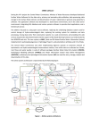
In January 1993 the Geological Survey of Canada in conjunction with the Ontario
Geological Survey initiated a three year project involving the compilation and analysis of
a wide range of digital data over the Swayze greenstone belt (Figure 1) using geographic
information system (GIS) technology. The project was funded by the four-year Northern
Ontario Development Agreement (NODA), a subsidiary agreement to the CanadaOntario Economic and Regional Development Agreement (ERDA) initiated by the
governments of Canada and Ontario.
The scope of the project involved the compilation and analysis of geoscience data and the
production of digital datasets, hardcopy maps and analysis methodologies useful for
regional mapping and exploration within Ontario. Data have been provided by industry
partners (Falconbridge Ltd., Noranda Inc.) and government agencies (Ontario Geological
Survey, Geological Survey of Canada), purchased, or digitized from maps. In all cases, as
much of the raw data attributes have been retained as possible. As part of the compilation
process, however, some changes have been made to standardize formats, projection, and
legend information to allow ease of use on various platforms and GIS software.
Exploration companies, Falconbridge Ltd., and Noranda Inc., contributed proprietary
data (both digital and analog) as well as exploration expertise which was essential for a
thorough analysis of the data with respect to regional geologic exploration models.
Working directly with exploration companies within the scope of the project was
essential as the data and analysis techniques developed were directly utilized by
companies working in the study area. Furthermore, the expertise held by exploration
companies were directly utilized within a GIS framework, allowing for realistic and
useful results to be obtained.
The objective of this CD-ROM release is thus to provide a ready-made, georeferenced,
digital database that the novice GIS user can immediately use with the provided viewer,
and that more advanced GIS users can import easily into their GIS system directly or by
using the provided common interchange formats. Please note that hydrological, lake-
NODA Swayze greenstone belt GIS database project user’s guide
2
sediment geochemical data and remotely sensed data (listed in Appendix A) have
not been included on this issue of the CD as royalty charges for these data would
make the cost of this CD prohibitive. However, pertinent ordering information for
the 1:50000 scale NTS map sheets that cover the area, available digital lake
sediment data, and remotely sensed data has been included for the users
convenience in Appendix A.
Another GSC Open File, (CD-ROM) (D3771), contains many of the various posters
prepared by J. Harris, L. Wilkinson, and others dealing with analysis of many of the
datasets included in this CD release. These posters which summarize how the data may
be visualized, analyzed and integrated into mineral favourability maps are stored in .PDF
format for viewing with Adobe Acrobat®.
James
Bay
Kapuskasing
Structure
ABITIBI
GREENSTONE
Timmins
BELT
Hemlo
Val D'or
Kirkland
Lake
Greenstone Belts
SWAYZE GREENSTONE
BELT STUDY AREA
0
300
Figure 1 – Location of Swayze greenstone belt
2 Hardware and Software Requirements
For PC users, a free data viewer, created on the CD with ESRI’s Arcview Data
Publisher®, is included. The NODA Swayze GIS viewer, a clone of ArcviewII 1 that can
1
Arcview I and II are data visualization software packages distributed by Environmental Systems Research
Institute Inc. (ESRI) that allows display, overlay and querying of data stored in ESRI Arc/Info format.
There are numerous data visualization packages available commercially and the choice of Arcview Data
NODA Swayze greenstone belt GIS database project user’s guide
3
only be used with this CD, is useful for those with no installed GIS software of their own,
or with little experience with GIS software. It comes with a set of pre-made graphical
views of the data, and allows users to create their own views, and query and analyze the
data sets via these views. To install this program requires a minimum of 7 Megabytes of
hard disk space and allows the user to access the over 600 Megabytes of data directly
from the CD. No viewing software is provided for Mac or Unix clients on this CD.
Installation of provided viewer
•
•
•
•
•
•
•
•
•
•
insert CD-ROM into CD drive of PC.
on Windows 95 click on "Start", then "Run", then "Browse".
navigate to your CD drive, then double-click "Setup.exe".
click on "OK" to start installation .
(during installation, click on "Continue" to proceed when required).
at "Please choose component(s) you would like to install", choose "NODA"
(required). Only choose "DATA" if you want to store and access the data from your
hard drive (600MB!) instead of the CD.
at "Path", enter a path where NODA Swayze GIS Viewer will be installed, or leave
the default path as is.
a DOS window will open to copy files to your PC. When the "File(s) copied"
message appears, terminate the DOS window by clicking on the upper right hand "X"
button.
wait while a Program Window appears and icons for the Viewer are copied. Continue
waiting until the message window appears, then click on "Continue".
you can copy the NODA Swayze GIS Viewer shortcut icon from the Program
Window to your desktop and use it to start the program, or you can select the program
by clicking on "Start", then "Programs", then "NODA" in Windows 95®.
Alternatively, the data can be copied directly to a users hard drive for use by software of
their own choosing. This does not require 600 plus Megabytes of hard disk space since a
user will normally only use one or two of the available formats with their GIS system.
The individual formats typically take 100 to 150 Megabytes of hard disk space each (see
section 4 – Data Formats).
For more advanced GIS users, Arcview III® in conjunction with Spatial Analyst 2 and the
Weights of Evidence 3 mineral potential modeling package (WofE) can be used to view
and analyze the data on this CD-ROM.
Publisher for this CD was made as it is compatible with the Arc/Info GIS package used for data
management of GSC NATMAP projects. The GSC does not endorse ESRI over other available data
visualization packages. Arcview version II is available for IBM-compatible and Unix workstation
computers. On IBM-compatible computers Arcview requires Windows, Ver. 3.0 or higher, and at least a
80386-based computer with at least 4 Mbytes of RAM. A 100 Mbyte hard disk or larger is recommended
2
Spatial Analyst is available through ESRI Canada
NODA Swayze greenstone belt GIS database project user’s guide
4
Due to space constraints on the CD, two versions of the data set have been compressed.
The DXF and MapInfo (MIF) formats (see section 4 – Data Formats ) are not needed by
the included viewing software and the data in these formats have been compressed with
PKZIP software. They can be uncompressed to your harddrive using PKZIP version
2.04g or higher. PKZIP version 2.04g for DOS and PKZIP version 2.5 for Windows (32
bit) are both available on this CD in the \DATA\SOFTWARE\ directory. To install these
shareware programs, simply copy them to your hard drive, double –click on the file in
Windows Explorer, and follow the directions.
3 CD Information
This CD-ROM conforms to the ISO-9660 system independent standard. An ISO-9660formatted CD works identically on a PC, Macintosh or Unix workstation. The directory
and file structure of the CD can be viewed as if it were a conventional hard disk.
Although the file structure is system independent, the user must still deal with differences
in the way different operating systems format files, in particular ASCII files. ASCII files
are provided in IBM-compatible format. In order to use these files on Unix workstation,
they must be converted to Unix ASCII file format using the Unix “dos2unix” command
(see your Unix documentation).
Compact disks are a cost effective way of distributing large quantities of data but do have
some limitations. Data transfer rates of CD-ROMs are comparable to hard disks but
access times are much slower. The slow access time can have negative implications for
applications that require concurrent querying of several files. The speed of access to the
data can be greatly improved by copying them to the hard disk and reading them from
there.
4 Data Formats
4.1
Standard Data Formats
There are sub-directories under the \DATA directory that contain the data in a variety of
formats such as Arc/Info coverages, shape files (.shp), MapInfo files (.mif/.mid), ASCII
files (.dat/.def), and raster files (.tif, .bil). The \SHP and \MIF sub-directories have been
further sub-divided into \POLY, \LINE, \POINT, and \TEXT directories as required for
the database structure of these formats (see below).
3
the Weights of Evidence (WofE) add-on to Arcview® is available, free-of-charge from the Geological
Survey of Canada – down-load from website http://gis.nrcan.gc.ca/software/Arcview/wofe
NODA Swayze greenstone belt GIS database project user’s guide
4.1.1
5
ARC
Stored in the \DATA\ARC sub-directory, Arc/Info format files can be read directly by
Arc/Info, ArcExplorer and Arcview on all supported platforms. They include point,
vector, and polygon coverages as well as grids. All grids are named with *_g extension.
4.1.2
MIF
Stored in the \DATA\MIF sub-directory, MapInfo files include both .mif and .mid files
for geometry and attribution. Note that these files are zipped to reduce file size and that
point, vector, and polygon files within this format are stored in separate sub-directories
within the zip files.
4.1.3
SHP
Arc/Info shape files are stored under the \DATA\SHP sub-directory and can be opened
directly in Arcview or the included viewer. Note that each data set is separated further by
data type (i.e., vector, polygon, point, or text).
4.1.4
ASCII
ASCII data files are composed of matching pairs of files with .def and .dat extensions.
The .def files provide a listing of the database field definitions (name, length, type, etc.).
The .dat files are comma delimited text files containing complete listings of all the
records of all point coverages, including easting and northing information. These files
may be imported into spreadsheet or database software packages.
Note that this data can be very useful to CAD users. Since the DXF files (see below) can
not contain values for all the attributes of the database records when converting to .dxf
format, one of the fields in the database has been provided as a reference, or look-up
field. For example, the record number, or an identifier string from the record, is viewable
from within AutoCAD. Using this reference, the ASCII .dat file can be used to view the
record’s remaining attributes.
4.1.5
RASTER
Arcview raster images are provided in .bil (band interleaved by line) and .tif (TIFF)
format. BIL and TIF images can be displayed directly in Arcview II or imported to other
software packages such as MapInfo. Additional files (.hdr, .stx, .clr for .bil and .tfw for
.tif) included on the CD are required for the image to display properly in Arcview. These
raster files can also be directly imported into Arc/Info as grids by using the imagegrid
command with Arc/Info software (not included on this CD).
NODA Swayze greenstone belt GIS database project user’s guide
4.2
6
Interchange Formats
Several common interchange file formats are provided on the CD-ROM to ensure
maximum compatibility of the data with a wide range of GIS and CAD systems. File
formats are identified by their subdirectory name (e.g. E00, DXF) and each format is
discussed below.
4.2.1
E00
Stored in the \DATA\E00 sub-directory, Arc/Info’s ASCII interchange format allows
Arc/Info coverages to be read by Arc/Info on all platforms. The format is also supported
by many other GIS packages. As with any ASCII files on the CD-ROM, .e00 files must
be converted to UNIX ASCII format for use on UNIX workstations.
4.2.2
DXF
Stored in the \DATA\DXF sub-directory, ASCII-format .dxf files are widely used by
both CAD and GIS software to interchange line and point data. By definition, .dxf files
do not support topology for polygon files. However, polygon attribute information can be
associated to .dxf files as attributes tagged to text located inside polygons. Note that some
maps have no attributes usable as layer names in .dxf format, and, no map has kept the
non-dxf attributes during the conversion. However, the non-dxf attributes from point files
can be viewed from the associated ASCII-format .dat/.def files mentioned in section 4.1.4
above. For vector (line) files, the type of line (e.g., fault, contact, etc) is often used as the
layer name for use by the CAD program, and they can therefore be sorted by layer name
to differentiate line types.The .dxf file set has been zipped to reduce file size. Once
unzipped, the .dxf files must be converted to UNIX ASCII format for use on UNIX
workstations.
4.3
Support Formats (metadata)
Several files are included on the CD-ROM to support and enhance the digital data
information, including marginal notes, data structure and legends. These files are also
identified by their extension and are listed below:
4.3.1
APR
In the root directory of the CD-ROM is a file called SWAYZE.APR. This .apr file format
is used by Arcview to store a collection of views of the data which are immediately
useable in Arcview. See Section 2, Hardware and Software Requirements, for more
information.
4.3.2
TXT
All data structure files, marginal notes and metadata are provided in DOS compatible
ASCII format in files ending with the .txt extension. As with any ASCII files on the CDROM, .txt files must be converted to UNIX ASCII format for use on UNIX workstations.
NODA Swayze greenstone belt GIS database project user’s guide
4.3.3
7
DOC
Marginal notes and other supporting documentation are provided in Microsoft Word for
Windows, version 6, as files ending with .doc.
4.3.4
HTM
This user guide is also provided in HTML and can be opened with any Internet browser
or any HTML viewer.
4.3.5
KEY
These files duplicate the full polygon legend presented on the hardcopy map in DOScompatible format. They can be read for better understanding of the map data but are
specifically intended for use by Arc/Info users to plot a simple legend for the map. As
with any ASCII files on the CD-ROM, .key files must be converted to UNIX ASCII
format for use on UNIX workstations.
4.3.6
AVL
Also included in the directories for the geology polygon files are .avl files. These can be
used to colour each map when in Arcview by double clicking on the geology polygon
theme and then loading the .avl file. The geology maps have already been coloured using
these .avl files in the geology view from the swayze.apr project file.
5 Projection
All data is provided in UTM Zone 15, NAD83 projection. In the case of point data such
as till geochemistry where the original coordinates provided were in a different
projection, both the original coordinates and the UTM projection coordinates are
provided.
6 Directory Structure
Root directory:
The root directory of the CD-ROM contains various federal government regulatory files:
citation.txt
license.txt
readme.txt
lisezmoi.txt
Proper citation for the CD-ROM
License agreement information
Brief overview to get you started using the CD-ROM
Version Francais - commencer a utiliser la disque.
Sub-directories:
NODA Swayze greenstone belt GIS database project user’s guide
DATA
8
Contains all the actual digital data divided first by format (ARC, E00, DXF,
MIF, SHP, RASTER, ASCII) and then by data set (e.g. DRILCORE,
GEOLOGY, GEOPHYS, QUAT, LITHCHEM, MINERAL, NTS, ROADS,
TWP) and lastly by source or type or other characteristic (e.g.
GEOLOGY\GOO, GEOLOGY\GSC, GEOPHYS\EM,
GEOPHYS\GAMMA). For example, the Arc/Info map TRACE83 would be
found in \DATA\ARC\LITHCHEM\TRACE\TRACE83, and the e00 version
of the Geology of Ontario map would be found in
\DATA\E00\GEOLOGY\GOO\GOOGEOL.E00. All files needed to use the
Arc/Info versions of the digital data (e.g. structure of data information, legend
information) are also provided in each directory with the data.
DOC
Holds the user guide (this document in various formats).
SOFTWARE Contains miscellaneous shareware or freeware useful in dealing with these
datasets.
7 Data Sets
The following data sets are provided on this CD-ROM. Data format sub-directories can
be substituted for “{FORMAT}” in the path (See Section 4.1, Interchange formats, for
descriptions of each format).
7.1
National Topographic System boundaries (\DATA\{format}\NTS)
Map
Source
Description
nts250
nts50
GSC
GSC
Boundaries of 1:250,000 NTS map sheets
Boundaries of 1:50,000 NTS map sheets
7.2
Township boundaries (\DATA\{format}\TWP)
Map
Source
Description
swayze
twp
GSC
OGS
Boundaries of study area
Township boundaries
7.3
Roads (\DATA\{format}\ROADS)
Map
Source
Description
kbroads
GSC
mbroads
OGS
Logging roads compiled from airphotos, field work and
NTS map sheets
Logging roads compiled from airphotos, field work and
NTS map sheets
NODA Swayze greenstone belt GIS database project user’s guide
7.4
Drillcore (\DATA\{format}\DRILCORE)
Map
Source
Description
dcore83
OGS
Location of drillholes and associated attributes
7.5
9
Lithogeochemical data (\DATA\{format}\LITHCHEM)
Map
Source
Description
path \DATA\{format}\LITHCHEM\MAJORS
wra83 /
OGS, GSC, Lithogeochemical data – raw and cleaned / screened
wracl83
Falconbridg
e Ltd.
path \DATA\{format}\LITHCHEM\TRACE
trace83
Includes all oxides (as in wra83) as well as trace elements
7.6
Mineral data (\DATA\{format}\MINERAL)
Map
Source
Description
min83
OGS
Locations as well as basic attributes of mineral deposits
and occurrences
7.7
Map
Quaternary data (\DATA\{format}\QUAT)
Source
Description
(path \DATA\{format}\QUAT\SURFMAPS)
gooquat
OGS
Surficial polygons (1:1,000,000 scale)
mbqto10
OGS
Surficial polygons for NTS 52o10 (1:50,000)
(path \DATA\{format}\QUAT\AUGRAIN)
augr83
OGS
Gold grain counts
(path \DATA\{format}\QUAT\BSOIL)
bhor83
OGS
Geochemical analysis of b-horizon soil profile
(path \DATA\{format}\QUAT\TILL)
tilicp83 /
OGS
Geochemical analysis of till (C-horizon) ICP and INAA
NODA Swayze greenstone belt GIS database project user’s guide
tilina83
10
analyses
(path \DATA\{format}\QUAT\STRIAE)
mbstriae
OGS
Glacial striae measurements
7.8
Map
Geophysics (\DATA\{format}\GEOPHYS)
Source
Description
(path \DATA\{format}\GEOPHYS\EM)
swdc_g /swdcs_g
OGS
Decay constant (raw values and stretched 8 bit values
from 0 to 255)
swde_g /swdes_g
OGS
Decay constant (deherringboned) 4
swres_g /swress_g
OGS
Resistivity (raw values and stretched 8 bit values from 0
to 255)
swrdf_g /swrdfs_g
OGS
Resistivity (raw values and stretched 8 bit values from 0
to 255 – deherringboned and filtered))
(path \DATA\{format}\GEOPHYS\GAMMA\LOW)
ura_g83 /urae_g83
GSC
Equivalent uranium (eU) (linear and equalized stretch of
raw data – 8 bits from 0 to 255)
thor_g83 /thoe_g83 GSC
Equivalent thorium (eTh)(linear and equalized stretch of
raw data – 8 bits from 0 to 255)
pota_g83 /pote_g83 GSC
Percent potassium (%K)(linear and equalized stretch of
raw data – 8 bits from 0 – 255)
(path \DATA\{format}\GEOPHYS\GAMMA\MEDIUM)
uraw_g /urawe_g
GSC
Equivalent uranium (eU) (linear and equalized stretch of
raw data – 8 bits from 0 – 255)
thraw_g /thrawe_g
GSC
Equivalent thorium (eTh)(linear and equalized stretch of
raw data – 8 bits from 0 – 255)
kraw_g /krawe_g
GSC
Percent potassium (%K)(linear and equalized stretch of
raw data – 8 bits from 0 – 255)
thrk_g /thrk_g
GSC
Thorium/potassium ratio grid (linear and equalized
stretch of raw data – 8 bits from 0 – 255)
urk_g /urke_g
GSC
Uranium/potassium ratio grid (linear and equalized
stretch of raw data – 8 bits from 0 – 255)
urth_g /urthe_g
GSC
Uranium/thorium ratio grid (linear and equalized stretch
of raw data – 8 bits from 0 – 255)
(path \DATA\{format}\GEOPHYS\GRAVITY)
grv_g83
GSC
Raw data (milligals)
4
Centurion Magnetic and EM Viewing Software – OGS, 1996
NODA Swayze greenstone belt GIS database project user’s guide
grvs_g83
GSC
11
Raw data stretched to 8 bits from 0 – 255
(path \DATA\{format}\GEOPHYS\MAG\GSC)
mg_g83 /mgse_g83 GSC
Mag from southern Swayze (raw, and stretched,
equalized from 0 to 255)
mg0_g83 /
GSC
Shaded relief mag from southern Swayze (raw, 0
mg45_g83
degrees (N) and 45 degrees (NE) using 30 degree
elevation)
gsm_g83 /gsms_g83 GSC
Low resolution mag (raw, and stretched to 8 bits from 0
– 255)
gm0_g83/gm45_g83 GSC
Shaded relief low res mag (0 degrees (N), and 45
degrees (NE) using 30 degree elevation)
(path \DATA\{format}\GEOPHYS\MAG\NORANDA)
swtf_83g /swtfse_g / Noranda Mag data (raw, and equalized, and linear stretch from 0
Inc.
swtfsl_g
to 255)
swvgs_g /swvgse_g Noranda Vertical gradient (linear stretch, and equalized stretch)
swtf0_g /swtf45_g
Inc.
Noranda
Inc.
Shaded relief (0 degrees (N), and 45 degrees (NE) – 30
degree elevation)
(path \DATA\{format}\GEOPHYS\MAG\OGS)
swmols_g/swmoss_g OGS
Total field smoothed, and total field smoothed and
stretched between 0 and 255)
swvds_g /swvdss_g
OGS
Vertical gradient – smoothed, smoothed and stretched
from 0 to 255
7.9
Map
Geology data (\DATA\{format}\GEOLOGY)
Source
Description
(path \DATA\{format}\GEOLOGY\COMPOSIT)
compgeol
OGS
Geology polygons and arcs (OGS 1:253,000 map series
compdyke
OGS
Mapped Dykes
compflt
OGS
Mapped faults
compfold
OGS
(path \DATA\{format}\GEOLOGY\FALCGEOL)
falcgeol
OGS
Compilation of OGS open file maps
falcolay
OGS
Contacts, faults
(path \DATA\{format}\GEOLOGY\GOO)
googeol
OGS
Geology polygons (1:1,000,000 scale)
goodyke
OGS
Dykes
gooflt
OGS
Faults
NODA Swayze greenstone belt GIS database project user’s guide
12
(path \DATA\{format}\GEOLOGY\NSWAYZE\MAP)
nswaygeo
OGS
Geology polygons (1:50,000 sclae)
nswaylay
OGS
Contacts, faults, dykes
nswaypts
OGS
Field measurements
nswaymin
OGS
Mineral occurrences
(path \DATA\{format}\GEOLOGY\ NSWAYZE\FIELD)
jastruc
OGS
Field measurements
(path \DATA\{format}\GEOLOGY\GSC\FIELD
alter83
GSC
Alteration mapped in the field
fold83
GSC
Fold type mapped in the field
foli83
GSC
Foliation measurements
fract83
GSC
Fracture measurements
geochn83
GSC
Locations and descriptions of geochron samples
outcr83
GSC
Locations and descriptions of outcrops
photo83
GSC
Locations of photos taken in field
sample83
GSC
Locations of rock samples taken in field
shearz83
GSC
Locations and descriptions of shear zones mapped in the
field
struct83
GSC
Structural measurements
(path \DATA\{format}\GEOLOGY\GSC\MAPS\*)
* - this section duplicated for sub-directories \NTS41o8, \NTS41o10, \NTS41o15,
\NTS41o16, \NTS41p5, \NTS41p12, \NTS41p13 and \GENERAL
geolpoly
hst83
geolline
geoltext
geochron
outcrops
structur
GSC
GSC
GSC
GSC
GSC
GSC
GSC
general
GSC
Lithological polygons
High strain zones mapped in the field
Faults, fold axes, contacts
Annotations for labelling (text)
Geochronology sample locations
Outcrop locations
Locations of structural measurements (for map display
only – see \gsc\field\foli83, shearz83, fold83, and
fract83 (above) for full data on structural observations)
Generalized geology map of study area
8 Disclaimer and Copyright
Although every attempt has been made to ensure that the contents of this CD-ROM are as
accurate as possible, the data on this CD-ROM is provided on an “as-is” basis.
The data on this CD-ROM, including this user’s guide, are protected by Crown
copyright. The receiving institution, or person, shall not sell, distribute, rent, sub-license
or lease the CD-ROM or its contents or any part of the contents.
NODA Swayze greenstone belt GIS database project user’s guide
13
9 Acknowledgments
The authors would like to thank the following companies, institutions and people who
participated and supported this project.
¾ Falconbridge Ltd. – R. Band, K. Watson, B. Jeffries, M. Collison, N. Provins
¾ Noranda Inc. – R. Dahn
¾ Ontario Geological Survey – M. Berneir, S. Fumerton, J. Ayer, G. Merlino, A. Fyon,
J. Wood, P. Thurston, C. Baker, H. Neusome
¾ Geological Survey of Canada – J. Broome, K. Heather, G. Shore, S. Colvine, J. King,
S. Lucas
NODA Swayze greenstone belt GIS database project user’s guide
14
10 APPENDIX A - Data sources and ordering information
GEOCHEMISTRY
Till / Soil / Humus Bernier, M.A. and Kaszyki, C.A., 1995. Till, humus and B-horizon soil geochemical
database, Surficial Sediment Sampling Program, Swayze greenstone belt, Norhtern
Ontario, 1992-94; Ontario Geological Survey, miscellaneous Release - Data 15
Gold Grain Counts
Bernier, M.A., 1995. Data to accompany OFR 5898 and Preliminary Maps P. 3264-65, P.
3323-27 Heavy mineral, pariculate gold and Au analysis results, Surifical Sediment
Sampling Program, Swayze greenstone belt, Northern Ontario, District of Timmins,
1992-1994. Ontario Geological Survey, Miscellaneous Release – Data 12
Lithogeochemistry
Haus, M. and Pauk, T. 1993. PETROCH lithoeochemical data; Ontario Geological
Survey, Open File Report 5855, 18p
Ayer, J. 1997. Precambrian geology of the northern Swayze greenstone belt, OGS Report
297
Heather, K- GSC- (unpublished)
Texas Gulf Survey – supplied by Falconbridge Ltd. (unpublished)
Falconbridge Survey – supplied by Falconbridge Ltd. (unpublished)
Fumerton, S. (OGS) – compilation of assessment files
GEOPHYSICS
Magnetics
GSC – 800 m grid regional data – Geophysical Data Centre (contact : Joan Todd,
W. Miles – 615 Booth Street – 613-992-6438 )
OGS - high resolution data – ERLIS dataset CD 1015 – Swayze greenstone belt
EM
OGS - high resolution data – ERLIS dataset CD 1015 – Swayze greenstone belt
DRILLHOLE
NODA Swayze greenstone belt GIS database project user’s guide
15
Ontario GEOservices Centre 1995. The Ontario Drill Hole Database (ODHDB), Ontario
Geological Survey, 28 Mbytes – Data Set 13
MINERAL PROSPECTS
Fumerton, S.L., Houle, K.A. and Archibald, G. 1995. Digital data on mineral prospects in
the Swayze greenstone belt. Plus a computer application to update and edit data using
FoxPro: Ontario Geological Survey, Open File Report 5911,120p.
GEOLOGY
Northern Swayze
Ayer, J., and G. T. Shore, 1995. Precambrian Geology, Northern Swayze greenstone belt,
Ontario Geological Survey, 2000 Map Series, M2549
Southern Swayze
Heather, K.B.1999: Legend and notes for Open Files 3384b-3384i (NTS 41P/05, 08,
09, 10, 12, 13, 15, 16), Swayze greenstone belt, Ontario, Geological Survey of Canada,
Open File 3384a.
1999: Geology, Rollo Lake sheet (41P/15), Swayze greenstone belt, Ontario, Geological
Survey of Canada, Open File 3384b, 1:50 000 scale.
1999: Geology, Rush Lake sheet (41P/16), Swayze greenstone belt, Ontario, Geological
Survey of Canada, Open File 3384c, 1:50 000 scale.
1999: Geology, Mattagami Lake sheet (41P/13), Swayze greenstone belt, Ontario,
Geological Survey of Canada, Open File3384d, 1:50 000 scale
1999: Geology, Sultan sheet (41P/10), Swayze greenstone belt, Ontario, Geological
Survey of Canada, Open File 3384e, 1:50 000 scale.
1999: Geology, Opeepeesway Lake sheet (41P/09), Swayze greenstone belt, Ontario,
Geological Survey of Canada, Open File 3384f, 1:50 000 scale.
1999: Geology, Gogama sheet (41P/12), Swayze greenstone belt, Ontario, Geological
Survey of Canada, Open File 3384g, 1:50 000 scale.
1999: Geology, Biscotasing sheet (41P/08), Swayze greenstone belt, Ontario,
Geological Survey of Canada, Open File 3384h, 1:50 000 scale.
1999: Geology, Westree sheet (41P/05), Swayze greenstone belt, Ontario, Geological
Survey of Canada, Open File 3384i, 1:50,000 scale.
NTS – BASE DATA (drainage, topography)
NODA Swayze greenstone belt GIS database project user’s guide
16
This data has not been included on this CD due to royality issues as previously
mentioned. However the following 1:50,000 maps sheets cover the study area and are
available in digital format: 41O/15, 41O/16, 41P/13, 41O/10, 41O/9, 41P/12, 41O/8,
41P/5. These are available for purchase from:
Geomatics Canada
NTDB Customer Support Group
Centre for Topographic Information
2144 King St. West, suite 010
Sherbrooke, Quebec
J1J 2E8
tel: 1-800-661-2638
fax: 819-564-5698
Internet: http://www.ccg.rncan.gc.ca
LAKE SEDIMENT DATA
This data is also not included on the CD but the area is covered by National Geochemical
Reconnaisance (NGR) lake sediment surveys available as GSC Open File Reports # 1357
and # 1657. This data can be purchased from the Geological Survey of Canada (P.
Friske).
REMOTELY SENSED DATA
Remotely sensed data for the study area can be ordered directly from Radarsat
International:
RADARSAT International Headquarters
13800 Commerce Parkway
MacDonald Dettwiler Building
Richmond, British Columbia
V6V 2J3
CANADA
Tel: (604) 231-5000
Fax: (604) 231-4900
NODA Swayze greenstone belt GIS database project user’s guide
17
11 Appendix B – Reports and papers dealing with compilation
and analysis of the data on this CD-ROM
Ayer, J., 1995. Precambrian geology, northern Swayze greenstone belt, District of
Sudbury; Report 297, Ontario Geological Survey, 57 pp.
Bernier, M.A., C.A. Kaszycki, l. Wilkinson and J.R. Harris 1995. Proportionally Sized
Circle Plot of Particulate Gold Abundance in Surficial Sediments ( -10 Mesh Size
Fraction), Swayze greenstone belt, Superior Province, Ontario, GSC Openfile Map 3130,
OGS Preliminary Map P. 3326.
Bernier, M.A., C.A. Kaszycki, l. Wilkinson and J.R. Harris 1995. Proportionally Sized
Circle Plot of Particulate Gold Abundance in Surficial Sediments ( -230 Mesh Size
Fraction), Swayze greenstone belt, Superior Province, Ontario, GSC Openfile Map 3131,
OGS Preliminary Map P. 3327.
Centurion Magnetic and EM Viewing Software – OGS, 1996
Fumerton, S,. L. Wilkinson, J.R. Harris. 1995. Mineral Occurrences in the Swayze
greenstone belt, Superior Province Ontario. GSC Openfile Map 3134, OGS Preliminary
Map P. 3330.
Fumerton, S. and Houle, K., 1993. Mineral showings, occurrences, deposits and mines of
the Swayze greenstone belt, interim report. Volumes 1 and 2; Ontario Geological Survey,
Open File Report 5871, 763 pp.
Fumerton, S., Houle, K. and Archibald, G., 1993. Digital data on the mineral showings,
occurrences, deposits and mines of the Swayze greenstone belt, plus a computer
application to update and edit the data using Foxpro_, interim report; Ontario Geological
Survey, Open File Report 5872, 112 pp.
Harris J.R., L. Wilkinson, E. Grunsky, K. Heather, and J. Ayer 1999. Techniques for
Analysis and Visualization of Lithogeochemical Data with Applications to the Swayze
greenstone belt, Ontario, (submitted to Journal of Geochemical Exploration – in press).
Harris J.R., Wilkinson L. and J. Broome 1995. Mineral Exploration Using GIS-Based
Favourability Analysis, Swayze greenstone belt, Northern Ontario, in Proceedings of the
Canadian Geomatics Conference (CD-ROM), National Defense.
Harris J.R., Wilkinson L. and J. Broome 1995. The GIS/Database project: Progress in the
Swayze greenstone belt, NODA Summary Report, edited by L. Owsiacki, M. Walters, H.
Brown , R. Shannon, pp. 110-116.
Harris, J. and Wilkinson, L. 1999. Swayze Greenstone Geoscience Dataset : Results form
data analysis using GIS technology, GSC Open File CD – D3731.
NODA Swayze greenstone belt GIS database project user’s guide
18
Harris, J. R., Broome, J. and Heather, K.B. 1993. Swayze greenstone belt GIS Project.
NODA Summary Report 1993-1994 pp. 115-121.
Harris, J.R. and L. Wilkinson . 1995. IHS Transformed Total Field Magnetics/Gravity
and EM Conductors, Swayze greenstone belt, Superior Province, Ontario, GSC Openfile
Map 31302 OGS Preliminary Map P. 3328.
Harris, J.R. and Wilkinson L. 1999. Drift Exploration in Glaciated Terrain, Short Course
Notes presented during the 19th International geochemical Exploration Symposium,
Vancouver, British Columbia, sponsored by the Association of Exploration Geochemists,
Chapter 6, pp. 182-210.
Harris, J.R., Grunsky, E.C. and Wilkinson,L. 1997. Developments in the effective use
and interpretation of lithogeochemistry in regional exploration programs: application of
GIS technology. Proceedings of Exploration 97: Fourth Decennial International
Conference on Mineral Exploration, edited by A.G. Gubins, pp. 285 – 292.
Harris, J.R., Grunsky, E.C. and Wilkinson,L. 1999. Effective use and interpretation of
lithogochemical data in regional exploration programs, (submitted to Ore Geology
Reviews – in press).
Harris, J.R., Wilkinson, L., Heather, K.B., Fumerton, S., Bernier, M., Ayer, J., and Dahn,
R. 1999. Mesothermal gold potential of the Swayze greenstone belt, Ontario: Application
of GIS technology (in press).
Harris, J.R., Wilkinson, L. and Broome, J. 1994. The GIS/Database Project: Progress in
the Swayze greenstone belt. NODA Summary Report 1994-1995. pp. 110 – 116.
Heather, K.B., 1989. The geological and structural setting of gold mineralization in the
Renabie portion of the Missanabie-Renabie gold district, Wawa gold camp; in Summary
of Field Work and Other Activities 1989, Ontario Geological Survey Miscellaneous
Paper 146, pp. 99-107.
Heather, K.B., 1993. Regional geology, structure, and mineral deposits of the Archean
Swayze greenstone belt, southern Superior Province, Ontario; in Current Research, Part
C; Geological Survey of Canada, Paper 93-1C, pp. 295-305.
Heather, K.B., 1998a-i (in press). Geology of the Swayze greenstone belt, Ontario; eight
(8) 1.50,000 scale maps and accompanying legend/marginal notes, Open File Maps
OF3384a-i, Geological Survey of Canada.
Heather, K.B., in prep. Tectonic Evolution of the Swayze greenstone belt, Ontario,
Canada; unpublished PhD Thesis.
Heather, K.B., Shore, G.T. and van Breemen, O., 1995. The convoluted "layer-cake". an
old recipe with new ingredients for the Swayze greenstone belt, southern Superior
Province, Ontario; in Current Research 1995-C, Geological Survey of Canada, pp. 1-10.
NODA Swayze greenstone belt GIS database project user’s guide
19
Heather, K.B., Shore, G.T. and van Breemen, O., 1996. Geological invetsigations in the
Swayze greenstone belt, southern Superior Province, Ontario; in Current Research 1996C, Geological Survey of Canada, p. 125-136.
Heather, K.B.and van Breemen, O., 1994. An interim report on geological, structural, and
geochronological investigations of granitoid rocks in the vicinity of the Swayze
greenstone belt, southern Superior Province, Ontario; in Current Research 1994-C;
Geological Survey of Canada, p. 259-268.
Wilkinson, l. and J.R Harris. 1995. IHS Transformed 1:1,000,000 Bedrock Geology of
Ontario and Shaded Total Field Magnetics, Swayze greenstone belt, Ontario. GSC
Openfile Map 3133, OGS Preliminary Map P. 3329.
Wilkinson, l. and J.R Harris. 1995. Index Geology and Road Map, Swayze greenstone
belt, Superior Province, Ontario, GSC Openfile Map 3135, OGS Preliminary Map P.
3331.
Wilkinson, l. and J.R Harris. 1995. Jensen Classified Samples on IHS Transformed
Geology/Shaded Total Field Magnetics, Swayze greenstone belt, Superior Province,
Ontario, GSC Openfile Map 3136, OGS Preliminary Map P. 3332.
Wilkinson, L., Harris, J.R., and Grunsky, E.C., 1997 :Building a lithogeochemical
database for GIS analysis of the Swayze greenstone belt; Methodology, Problems and
Solutions, (submitted to the Journal of Geochemical Exploration – in press).