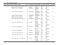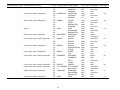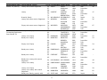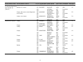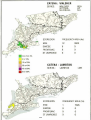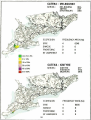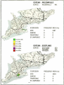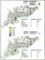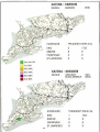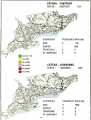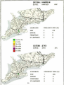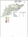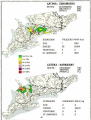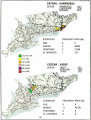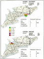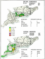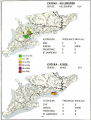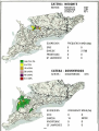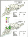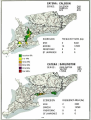
1
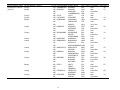
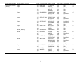
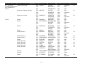
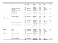
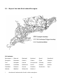
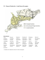
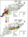
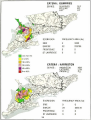
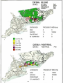
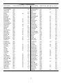
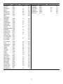
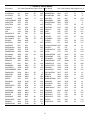
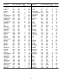
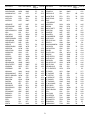
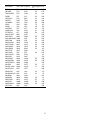
Research Branch
Technical Bulletin 1998-4E
Location and Extent
of The Soils of
Southern Ontario
A User's Guide to Series,
Catenae and Soil Legend
Information
I.E. Jarvis, K.B. MacDonald and K.A. Denholm
Soil Program at Guelph
Greenhouse and Processing
Crop Research Centre
Agriculture and AgriFood Canada
Soils Program at Guelph
Greenhouse and Processing Crops
Research Centre
70 Fountain St. East
Guelph, ON N1H 3N6
A New Publication from the Ontario Land Resource Unit (OLRU)
Please accept with our compliments a copy of the technical bulletin
Location and Extent of the Soils of Southern Ontario:
A user's guide to series, catenae and soil legend information.
This technical bulletin shows the relationship between soils of the agricultural regions of
southern Ontario mapped in detail by county and the generalized provincial level characterized
by the Soil Landscapes of Canada map (map scale 1:1,000,000). For general users and students
of soil science, the report provides an overview of the spatial distribution of soils across southern
Ontario. The soil legend provides information about the soil parent material deposits and texture
as well as the general category of surface soil drainage. For expert users of soil survey
information, this report is intended to provide a framework for broad level soil correlation. It
replaces the 1964 publication Soil Associations of Southern Ontario; Report 30.
For further information about this bulletin or other publications or activities of the Ontario Land
Resource Unit please contact:
Or
Dr. K. Bruce MacDonald,
Head, OLRU
70 Fountain St. East
Guelph, Ontario
N1H 3N6
Phone: 519-826-2086
Fax: 519-826-2090
Dr. G. Whitfield
Director, GPCRC
Highway 18
Harrow, Ontario
N0R 1G0
519-738-2251
519-738-2929
Please note:
After August, 1998 the OLRU will be closed and all enquiries should be directed to Dr.
Whitfield,
LOCATION AND EXTENT OF
THE SOILS OF SOUTHERN ONTARIO
A User's Guide to Series, Catenae and Soil Legend
Information
By
I.E. Jarvis
K.B. MacDonald
and
K.A. Denholm
Hard copy of this publication can be obtained from:
Soil Program at Guelph, Greenhouse and Processing Crop Research Centre
Research Branch, Agriculture and Agri-Food Canada
70 Fountain Street E.
Guelph, ON N1H 3N6
©Minister of Public Works and Government Services Canada 1998
Cat. No. A54-8/1998-4E
ISBN 0-662-26776-1
ACKNOWLEDGMENT
A project of this magnitude could not be undertaken without of the past and continuing
contribution of the Ontario soil survey community as a whole. In particular the authors
would like to acknowledge the contribution of L.W. Schut and E.A. Wilson of the Ontario
Ministry of Agriculture, Food and Rural Affairs, Resources and Regulations Branch, and D.
Kroetsch of the Eastern Cereals and Oilseeds Research Centre, Land Evaluation Program.
The Authors would also like to thank B.K. Hohner, D.W. Lee and B. Boulay for their technical
assistance in the preparation of this report.
3
TABLE OF CONTENTS
Page
1.
Background
5
2.
Soils of Ontario Legend
6
3.
The Location and Extent of Soils in Southern Ontario
7
3.1
7
A Generalization Model For Soils Information
4.
Legend
9
5.
Soil Maps
18
5.1
Lake Erie Lowlands Ecoregion
18
5.2
Manitoulin - Lake Simcoe Ecoregion
37
5.3
St. Lawrence Lowlands Ecoregion
62
5.4
Frontenac Axis Ecoregion
73
6.
Catena Index
74
7.
Series Index
76
8.
References
80
4
1.
Background
The Soil Associations of Southern Ontario, Report 30 of the Soil Survey of Ontario was published
in 1964 (Hoffman et al. 1964). The publication of the report coincided with the completion of the
county soil surveys for Southern Ontario. This was a landmark in the history of Ontario soil
survey. The objective of Report 30 was to create a generalized, small scale view of the soils for
the entire agricultural region of Southern Ontario. The generalization was based on soil
associations which are "groups of soils which occur together in the field and thus form a
significant landscape" (Hoffman et al. 1964) . The report also included a Key to the Soil Series
of Ontario, which has provided the definitive word on soil series and soil catenae classification.
Since publication, Report 30 has provided an important tool for pedologists, even though many
of the soil survey concepts have changed and many soil series have been added during recent
re-surveys. Consequently, there is a need to update the soils key and the maps showing the
distribution of Ontario soils.
Since the publication of Report 30, the status of the soil survey has evolved, as well, the tools
to manage data have improved. The Ontario soil survey has reached another landmark, the
completion of a digital version of the county soils database. With the data and tools now at hand
its now possible to describe the extent and distribution of Ontario soils with a degree of accuracy
and flexibility which was not previously possible. As well, there is a need to update the soils key
of Ontario to include present classification concepts and new soil series which have been
described since Report 30 was published. With these considerations in mind this technical
bulletin has been created to replace Report 30 by meeting the following objectives:
I.
To update the key to the soil series of Ontario from Report 30 and to present it in
the format of the Southern Ontario Soils Legend and;
ii.
To show the distribution and extent of soils in Southern Ontario at the catenae
level of generalization.
For expert users of soil survey information, this report is intended to provide the basis for
identifying and rectifying soil correlation issues. For non-expert users and students of soil
science the report provides a generalized overview of the distribution of soils and basic soil
properties for the entire Southern Ontario landscape.
Much of the work described has evolved from recent activities of the Ontario Soil Landscape
Attribute Project (OSLAP). The computer analysis and field work carried out for OSLAP have
resulted in a better understanding of the distribution of soils in Southern Ontario (Jarvis et al.
1996). In addition, recent work to upgrade county soil surveys in Eastern Ontario resulted in the
development of a generic legend for Ontario soils which provides a consistent view of the soil
classification hierarchy in Ontario. These projects have provided much of the background for this
report.
5
2.
Soils of Ontario Legend
The Soils of Ontario Legend (SOL) classifies the soils according to their physical properties and soil
forming conditions as expressed by soil profile characteristics. The purpose of the SOL is to present
the expert user with information which will aid the development of soil data applications, and
provide a tool for the pedologist to address soil correlation issues.
The SOL is presented in table 1. The soils of Ontario are classified using criteria from the Canadian
System of Soil Classification (CSSC, Agriculture Canada Expert Committee on Soil Survey, 1987).
The CSSC hierarchy consists of: Order; Great Group; Subgroup; Family; Series. In addition, the
CSSC series can be grouped into catena which have similar family level characteristics, but different
drainage. Catenae may transcend soil orders and as such are not part of the CSSC hierarchy,
however catenary organization has particular utility when describing the spatial distribution of soils
because they link landscape (landscape position) with series level criteria. The SOL is organized
by soil family, catena and series. The criteria for each of these classes include:
Soil Family
Differentiating criteria from the Order, Great Group, and Subgroup levels,
plus...
Parent Material Deposition
Soil Reaction (mineralogy)
Parent Material texture
Soil Series
Differentiating criteria from the Order, Great Group, Subgroup and family
levels, plus...
Detailed Features of Pedon including:
Colour
Texture
Structure
Layer Thickness
Soil Catena
Grouping of soil series with similar Parent Material Deposition,
Soil Reaction (mineralogy), and Parent Material texture plus ...
Different Drainage
The SOL is organized in order to reflect both the CSSC and Catenae criteria. The legend is
organized as follows (in order):
Parent Material Deposition
Parent Material texture
Catena Name
Drainage
Series Name
In order to assist the user, the SOL also includes unique line number identifiers for each series.
These numbers are used in the indexes (Section 6 and 7) to cross reference catenae and series
with the location of their soil extent and location maps.
6
3.
The Location and Extent of Soils of Southern Ontario
The digital spatial framework of county soil surveys was completed for the OSLAP project. This
spatial framework, in combination with GIS capabilities, has made it possible to describe the
location and extent of Ontario soils quantitatively. However, in order to present detailed county
information at such a broad scale it is necessary to generalize the data to a scale which is
appropriate to the presentation. A generalization model must address both data generalization and
spatial generalization. In Report 30 data generalization was based on common soil associations and
the spatial generalization was based on units of common deposition, similar to present day CSSC
family level criteria. These soil associations had little precision and quantification was not possible,
but the map still served the community well as the best source of data possible at that time. With
improvements in data and technology it is possible to be more precise in our generalization. The
OSLAP project has provided the theoretical model to guide data generalization and the Soil
Landscapes of Southern Ontario mapping framework is particularly well suited for describing the
broad scale distribution of soils.
3.1
A Generalization Model for Soils
Soils boundaries are not usually sharp, but rather appear as gradual transitions across the
landscape. As a result, soils mapping is conducted by bounding similar soils based on
discontinuities in selected characteristics. The characteristics used to map are defined to meet the
information needs of the user. Consequently, soil map delineation's are not arbitrary, but are scale
dependent models based on soil and landscape relationships. Scale determines spatial resolution,
for example, a detailed map is expected to have a larger number of soil units in a given extent than
a generalized soil map. Scale also influences attribute definition, for example, in a detailed map
texture can be narrowly defined using particle size analysis, whereas in generalized maps it is more
appropriate to use broad texture classes, reflecting the increase in variability as the extent
characterized increases. Consequently, changing the resolution changes the nature of attributes
in terms of class limits and attribute definition. The scale sensitivity of attributes are often
mis-understood and rarely documented. To rectify this a generalization model was adopted to guide
the revision of the Southern Ontario Soil Landscapes for the OSLAP project. The generalization also
permits the development of the location and extent of catenae maps presented in this report.
In Ontario detailed soil maps have been developed at scales ranging from 1:25,000 to 1:63,360
(one at 1:126,720), with a corresponding spatial resolution of 5 ha to 12.6 ha based on standard
cartographic principles (Monette and MacDonald 1992). The polygons represent soil series or soil
associations and are characterized by attributes derived from modal pedon data which describe the
soil series. In order to generalize county level soils mapping it is necessary to develop a compatible
model of soil and landscape at the broad scale (1:1,000,000). To guide the development of a
generalized soil landscape model we have looked to more recent work in the U.S. (USDA 1991) and
efforts at soil map generalization in Ontario (Cressman 1996). Based on the review the catena
concept was adopted as the general principle to guide the generalization of detailed attributes
(1:25,000 to 1:63,360) to the SLC scale (1:1,000,000).
7
Detailed soil mapping in Ontario has traditionally been based on a landscape model of series or
Association with attribute representations consisting of series level pedon data. Series consisting
of similar materials are differentiated based on drainage, which implies slope position. The catenae
model generalizes series by grouping similar soils with different landscape positions. The following
discussion briefly outlines the methods used to generalize series on detailed soil maps to catenae
on the generalized SLC map. A more detailed methodology is contained in Appendix B of the OSLAP
working paper (Jarvis et al. 1997).
The catena generalization was performed by developing an overlay of the SLC with detailed soil
maps (figure 1). The soil series proportions are summarized then generalized by grouping into
catenas. These catenas are the new SLC components and attribute data is developed based on the
dominant soil for each catena in each polygon.
Figure 1.
Generalization of Detailed Maps to Catena.
The maps which show soil extent and distribution in section 5 are based on these catenary
generalizations. Section 4 presents the Soils of Ontario Legend, which, among other things,
provides the catenae groupings that were used for soils data generalization. The legend and maps
are not comprehensive, they do not contain some soil catenae and series of limited extent in the
province. If necessary the minor soils can be found in the county soil survey reports.
8
4.
Soils of Ontario Legend
Parent Material Class Parent Material Texture
Glacial Till
Line # CATENA NAME SERIES NAME
SOIL CODE DRAINAGE
Map Page #
Loamy with some coarse fragments
1
ANCASTER
ANCASTER
ACE
Rapid
-
Sandy with coarse fragments
2
BALMER
BALMER
BMR
Well
-
Sandy with coarse fragments
3
BONDHEAD
BONDHEAD
BDH
Well
38
4
GUERIN
GUR
Imperfect
5
LYONS
LYS
Poor
BRYANSTON
BBY
Well
THORNDALE
THN
Imperfect
Loamy with coarse fragments
6
BRYANSTON
7
3
26
NISSOURI
NIS
Poor
BURNSTOWN
BURNSTOWN
BTW
Well
10
CAISTOR
CAISTOR
CTR
Imperfect
Sandy with coarse fragments
11
CHRISTY
CHRISTY
CIY
Poor
-
Loamy with some coarse fragments
12
DARLINGTON
DARLINGTON
DGT
Well
52
WHITBY
WBY
Imperfect
LYONS
LYS
Poor
DELORO
DLO
Well
16
DUMMER
DMM
Well
17
ROCKCROFT
RKF
Imperfect
18
HARNEY
HEY
Poor
DUMFRIES
DUF
Well
20
KILLEAN
KIL
Imperfect
21
LILY
LIY
Poor
DUNEDIN
DUD
Well
CRAIGLEITH
CGH
Imperfect
EGANVILLE
EGV
Well
STAFFORD
SFD
Imperfect
Loamy with coarse fragments
9
Clayey with coarse fragments
13
14
Loamy with coarse fragments
Loamy with coarse fragments
Clayey with coarse fragments
15
19
22
DELORO
DUMFRIES
DUNEDIN
23
Loamy with coarse fragments
24
EGANVILLE
25
Loamy with coarse fragments
Loamy with some coarse fragments
26
GRENVILLE
GVI
Well
27
MATILDA
MTD
Imperfect
28
LYONS
LYS
Poor
GUELPH
GUP
Well
30
LONDON
LOD
Imperfect
31
PARKHILL
PLL
Poor
29
GRENVILLE
GUELPH
9
25
40
39
51
63
42
Parent Material Class Parent Material Texture
Glacial Till (Cont'd)
Loamy with coarse fragments
Loamy with coarse fragments
Clayey with coarse fragments
Clayey
Sandy with coarse fragments
Loamy with some coarse fragments
Loamy with coarse fragments
Loamy with coarse fragments
Loamy with some coarse fragments
Loamy with some coarse fragments
Loamy with some coarse fragments
Sandy with coarse fragments
Loamy with coarse fragments
Line #
32
33
34
35
36
37
38
39
40
41
42
43
44
45
46
47
48
49
50
51
52
53
54
55
56
57
58
59
60
61
62
63
64
65
CATENA NAME SERIES NAME
HARKAWAY
HARKAWAY
WIARTON
PARKHILL
HARRISTON
HARRISTON
LISTOWEL
PARKHILL
HURON
HURON
PERTH
BROOKSTON
DORKING
KING
KING
MONAGHAN
BROOKSTON
MONTEAGLE MONTEAGLE
WEMYSS
MURIEL
MURIEL
GOBLES
KELVIN
ONEIDA
ONEIDA
CHINGUACOUSY
JEDDO
OSPREY
OSPREY
LILY
OTONABEE
OTONABEE
ELDORADO
EMILY
LYONS
SENECA
SENECA
ST CLEMENTS ST CLEMENTS
WELLESLEY
TENNYSON
TENNYSON
BALDERSON
INNISVILLE
VARS
VARS
10
SOIL CODE DRAINAGE Map Page #
HKY
Well
45
WIT
Imperfect
PLL
Poor
HRR
Well
39
LTW
Imperfect
PLL
Poor
HUO
Mod. Well
38
PTH
Imperfect
BKN
Poor
DKG
Very Poor
KIG
Well
54
MOG
Imperfect
BKN
Poor
MGL
Rapid
WYS
Imperfect
MUI
Mod. Well
21
GOB
Imperfect
KVN
Poor
OID
Well
19
CGU
Imperfect
JDD
Poor
OPY
Well
LIY
Poor
OBE
Rapid
42
EDO
Well
EMY
Imperfect
LYS
Poor
SNA
Well
36
SCM
Imperfect
WEY
Imperfect
TNY
Well
70
BDS
Imperfect
INV
Poor
VRS
Well
72
Parent Material Class Parent Material Texture
Glacial Till (Cont'd)
Loamy with coarse fragments
Line #
66
67
68
Loamy
69
70
71
Gravelly Sandy
72
Loamy with some coarse fragments
73
74
75
Clayey with some coarse fragments
76
77
78
Loamy
over
Clayey
79
40 - 100 cm of
Contrasting Sediments
80
Over Glacial Till
81
Loamy over Clayey
82
Sandy over Clayey
83
84
85
Clayey over Clayey
86
87
88
Sandy over Loamy
89
90
91
Sandy over Loamy
92
93
Sandy over Loamy with coarse
94
fragments
Loamy over Loamy
95
96
97
Loamy over Clayey
98
Loamy over Loamy with coarse
99
fragments
Sandy over Sandy, gravelly with
100
CATENA NAME SERIES NAME
VASEY
VASEY
HOWLAND
LYONS
VINCENT
VINCENT
KEMBLE
BROOKSTON
WILSONVILLE WILSONVILLE
WOBURN
WOBURN
MILLIKEN
LYONS
WOLFORD
WOLFORD
MORRISBURG
OSNABRUCK
BENNINGTON BENNINGTON
TAVISTOCK
MAPLEWOOD
BINBROOK
BINBROOK
BOOKTON
BOOKTON
BERRIEN
WAUSEON
CASHEL
CASHEL
PEEL
MALTON
DUNDONALD DUNDONALD
EDENVALE
MILL
FREEPORT
FREEPORT
KOSSUTH
SOIL CODE
VSY
HWD
LYS
VCT
KMB
BKN
WIL
WBU
MLE
LYS
WFD
MBG
OBK
BNG
TVK
MPW
BNO
BOO
BRR
WUS
CSH
PEL
MAT
DUL
EDV
MIL
FEP
KSU
DRAINAGE Map Page #
Well
46
Imperfect
Poor
Well
47
Imperfect
Poor
Rapid
31
Well
26
Imperfect
Poor
Well
67
Imperfect
Poor
Well
23
Imperfect
Poor
Imperfect
27
Well
23
Imperfect
Poor
Well
24
Imperfect
Poor
Well
48
Imperfect
Poor
Well
Imperfect
HILLSBURGH
HLH
Well
49
HONEYWOOD HONEYWOOD
EMBRO
CROMBIE
LAMBTON
LAMBTON
HYW
EBR
CMB
LMB
Well
Imperfect
Poor
Well
24
MANNHEIM
MANNHEIM
MNM
Well
60
SCOTLAND
SCOTLAND
STD
Rapid
31
11
HILLSBURGH
29
Parent Material Class
Parent Material Texture
40-100 cm of
coarse fragments
Contrasting Sediments
Sandy over Loamy
Over Glacial Till
(Cont'd)
Clayey with some coarse fragments
over Loamy
Loamy over Loamy
Lacustrine or Marine
Loamy
Clayey
Loamy
Clayey
Clayey
Clayey
Clayey
Sandy
Clayey
Line # CATENA NAME SERIES NAME
SOIL CODE DRAINAGE Map Page #
101 SCOTLAND
OAKLAND
OKL
Imperfect
31
102 WALSHER
WALSHER
WSH
Well
29
103
VITTORIA
VIT
Imperfect
104
105
106
107
108
109
110
111
112
113
114
115
116
117
118
119
120
121
122
123
124
125
126
127
128
129
130
131
132
133
SILVER HILL
WAUPOOS
SOLMESVILLE
LINDSAY
WOOLWICH
CONESTOGO
MARYHILL
ALMONTE
SNEDDEN
APPLETON
BLACKWELL
BRANT
TUSCOLA
COLWOOD
BRANTFORD
BEVERLY
TOLEDO
CARP
NORTH GOWER
BELMEADE
CLYDE
DALHOUSIE
BRANDON
GOODSTOWN
FOX
SULLIVAN
BRADY
GRANBY
GANANOQUE
LANSDOWNE
SIN
WPO
SMV
LSY
WOW
CTG
MYL
AMO
SND
APP
BCW
BRT
TUC
CWO
BFO
BVY
TLD
CRP
NGW
BMD
CYD
DHU
BDO
GDT
FOX
SVN
BAY
GNY
GQU
LDW
Poor
Well
Imperfect
Poor
Well
Imperfect
Poor
Well
Imperfect
Well
Poor
Well
Imperfect
Poor
Well
Imperfect
Poor
Imperfect
Poor
Very Poor
Poor
Imperfect
Poor
Very Poor
Rapid
Well
Imperfect
Poor
Well
Imperfect
WAUPOOS
WOOLWICH
ALMONTE
APPLETON
BLACKWELL
BRANT
BRANTFORD
CARP
CLYDE
DALHOUSIE
FOX
GANANOQUE
12
53
54
71
28
21
19
64
25
66
22
46
Parent Material Class
Lacustrine or Marine
(Cont'd)
Parent Material Texture
Clayey
Sandy
Clayey
Clayey
Sandy
Loamy
Clayey
Loamy
Loamy
Loamy
Loamy
Clayey
Sandy
Loamy
Clayey
Line #
134
135
136
137
138
139
140
141
142
143
144
145
146
147
148
149
150
151
152
153
154
155
156
157
158
159
160
161
162
163
164
165
166
167
CATENA NAME SERIES NAME
SOIL CODE
GANANOQUE NAPANEE
NPE
GRIMSBY
GRIMSBY
GMY
VINELAND
VLD
FLAMBOROUGH FMB
LEITH
LEITH
LTH
LOCKPORT
LOCKPORT
LKP
LOWBANKS
LOWBANKS
LOW
TRAFALGAR
TFG
MORLEY
MOY
MEDONTE
MEDONTE
MDT
LOVERING
LVR
ATHERLY
ATY
MELBOURNE MELBOURNE
MEL
EKFRID
EKF
STRATHBURN
SBN
MINESING
MINESING
MSG
NEWBURGH
NEWBURGH
NWG
PICADILLY
PAY
HINCHINBROOKE HHO
NEWCASTLE NEWCASTLE
NWC
MATSON
MTS
NORHAM
NORHAM
NHM
CODRINGTON
CGT
PETHERWICK
PWK
ONTARIO
ONTARIO
OTI
NIAGARA
NGR
WELLAND
WLL
PERCY
PERCY
PCY
TRENT
TRT
FOXBORO
FXB
PIPERVILLE
PIPERVILLE
PPV
OSGOODE
OGO
RENFREW
RENFREW
RFW
RIDEAU
RDU
13
DRAINAGE Map Page #
Poor
46
Well
27
Imperfect
Poor
Well
Well
44
Imperfect
34
Poor
Very Poor
Well
50
Imperfect
Poor
Well
30
Imperfect
Poor
Poor
57
Well
Imperfect
Poor
Well
55
Imperfect
Well
59
Imperfect
Poor
Mod. Well
28
Imperfect
Poor
Well
53
Imperfect
Poor
Imperfect
68
Poor
Well
70
Imperfect
Parent Material Class
Lacustrine or Marine
(Cont'd)
Parent Material Texture
Clayey
Clayey
Clayey
Loamy
Clayey
Clayey
Sandy, Gravelly
Sandy
Sandy
Sandy
Clayey
Sandy
Loamy
Line #
168
169
170
171
172
173
174
175
176
177
178
179
180
181
182
183
184
185
186
187
188
189
190
191
192
193
194
195
196
197
198
199
200
CATENA NAME SERIES NAME
RENFREW
ST ROSALIE
SAUGEEN
SAUGEEN
ELDERSLIE
CHESLEY
FERNDALE
SCHOMBERG SCHOMBERG
SMITHFIELD
SIMCOE
SEELYES' BAY SEELYES' BAY
BATTERSEA
MOSCOW
SMITHVILLE
SMITHVILLE
HALDIMAND
LINCOLN
SOUTH BAY
SOUTH BAY
ELMBROOK
SIDNEY
SPRINGVALE SPRINGVALE
UPLANDS
UPLANDS
RUBICON
ST SAMUEL
WATERLOO
WATERLOO
HEIDELBERG
WATTFORD
WATTFORD
NORMANDALE
ST WILLIAMS
CHURCHVILLE
WENDOVER
WENDOVER
BEARBROOK
WINONA
WINONA
WOOLER
WOOLER
MURRAY
STOCKDALE
14
SOIL CODE
STA
SGE
EDS
CLY
FRD
SMG
SMF
SMC
SYB
BTR
MCW
SHV
HIM
LIC
SHY
EOK
SlY
SRI
UPD
RUB
SSM
WTO
HIG
WAT
NDE
SLI
CHV
WDV
BBO
WIO
WOO
MUY
SKD
DRAINAGE Map Page #
Poor
70
Well
43
Imperfect
Poor
Poor
Well
45
Imperfect
Poor
Well
Imperfect
Poor
Mod. Well
20
Imperfect
Poor
Well
47
Imperfect
Poor
Well
Rapid
65
Imperfect
Poor
Well
43
Imperfect
Well
22
Imperfect
Poor
Very Poor
Imperfect
64
Poor
Imperfect
Well
59
Imperfect
Poor
Parent Material Class Parent Material Texture
40 - 100 cm of
Loamy over Clayey
Contrasting Sediments
over Lacustrine or
Marine
Sandy over Sandy, Gravelly
Sandy over Clayey
Fluvial
Sandy
Sandy
Sandy
Sandy
Sandy Gravelly
Sandy Gravelly
Sandy Gravelly
Sandy
Sandy, Gravelly
Sandy, Gravelly
Sandy, Gravelly
Sandy, Gravelly
Sandy, Gravelly
Gravelly
Gravelly
Sandy
Line # CATENA NAME
201
CASTOR
SERIES NAME
CASTOR
SOIL CODE DRAINAGE Map Page #
CST
Imperfect
202
BAINSVILLE
BIV
Poor
203
MARIONVILLE
MIV
Poor
KTY
HHG
MKK
MOK
MUA
ALL
BCF
BNK
WYD
GNY
BGH
TUH
GNY
BCO
BUF
BSB
GFD
CLB
DYK
ETP
FNT
HRW
KRS
LSB
PYO
SGT
GIY
SSW
STR
SHO
LAC
Well
Imperfect
Poor
Well
Imperfect
Poor
Well
Well
Imperfect
Poor
Well
Imperfect
Poor
Well
Well
Imperfect
Poor
Well
Rapid
Well
Well
Well
Well
Well
Well
Well
Imperfect
Well
Rapid
Well
Imperfect
204
205
206
207
203
209
210
211
212
213
214
215
216
217
218
219
220
221
222
223
224
225
226
227
228
229
230
231
232
233
234
KINTYRE
KINTYRE
HIGHGATE
MUIRKIRK
MANOTICK
MANOTICK
MOUNTAIN
ALLENDALE
BANCROFT
BANCROFT
BOLINGBROKE BOLINGBROKE
WAYSIDE
GRANBY
BRIGHTON
BRIGHTON
TECUMSETH
GRANBY
BRINCO
BRINCO
BURFORD
BURFORD
BRISBANE
GILFORD
COLBORNE
COLBORNE
DONNYBROOK DONNYBROOK
EASTPORT
EASTPORT
FONTHILL
FONTHILL
HARROW
HARROW
KARS
KARS
LISBON
LISBON
PONTYPOOL
PONTYPOOL
SARGENT
SARGENT
GWILLIMBURY
SHASHAWANDA SHASHAWANDA
ST PETERS
ST PETERS
ST THOMAS
ST THOMAS
ACHIGAN
15
67
30
68
-
44
48
58
50
34
33
69
58
40
69
Parent Material Class Parent Material Texture
Fluvial (Cont'd)
Sandy
Sandy with some Coarse
Fragments
Sandy with some Coarse
Fragments
Sandy with some Coarse
Fragments
Gravelly, Sandy
Gravelly, Sandy
Gravelly
40-100 cm of
Contrasting
Sediments
over Fluvial
Sandy over Gravely
Sandy over Sandy, Gravelly
Loamy over Gravely, Sandy
Loamy over Gravely, Sandy
Eolian
Sandy
Sandy
Lithic
Loamy over Bedrock
Sandy over Bedrock
Sandy over Bedrock
Variable over bedrock
Loamy over Bedrock
Line # CATENA NAME
235 ST THOMAS
SERIES NAME
CHENEY
SOIL CODE DRAINAGE Map Page #
CEY
Poor
69
TIOGA
TIG
Well
ALLISTON
GRANBY
WENDIGO
MALLARD
ALT
GNY
WDG
MLR
Imperfect
Poor
Rapid
Imperfect
WESTMEATH
WESTMEATH
WMH
Well
242
243
244
245
WHITE LAKE
WYEVALE
KENABEEK
WHITE LAKE
WYEVALE
HENDRIE
KEK
WHK
WVL
HDI
Poor
Rapid
Well
Imperfect
71
-
246
CALEDON
CALEDON
CAD
Well
52
CAMILLA
AYR
COLBORNE
BAMFORD
SHEDDEN
MIDDLEMARCH
ST JACOBS
FLORADALE
TEESWATER
FANSHAWE
BALLYMOTE
BRIDGMAN
PLAINFIELD
WALSINGHAM
WATERIN
AMELIASBURG
GEROW
ATHOL
BELMONT
BREYPEN
BROCKPORT
COOKSVILLE
CML
AYR
CLB
BMF
SDD
MDM
SJB
FAD
TEW
FAN
BLL
BGM
PFD
WAM
WRN
AUG
GOW
ATH
BMT
BPN
BKP
CKV
Imperfect
Poor
Well
Imperfect
Well
Imperfect
Well
Imperfect
Well
Imperfect
Poor
Well
Rapid
Imperfect
Poor
Well
Poor
Imperfect
Well
Poor
Well
Imperfect
236
237
238
239
240
241
247
248
249
250
251
252
253
254
255
256
257
258
259
260
261
262
263
264
265
266
267
268
TIOGA
WENDIGO
COLBORNE
SHEDDEN
ST JACOBS
TEESWATER
BRIDGMAN
PLAINFIELD
AMELIASBURG
ATHOL
BELMONT
BREYPEN
BROCKPORT
16
41
55
-
58
33
60
56
61
20
49
41
32
Parent Material Class
Lithic (Cont'd)
Parent Material Texture
Loamy over Bedrock
Loamy over Bedrock
Sandy over Bedrock
Sandy over Bedrock
Variable with coarse fragments
over bedrock
Sandy over Bedrock
Loamy over Bedrock
Sandy over Bedrock
Variable with coarse fragments
over bedrock
Organic
Alluvium
Sandy over Bedrock
Sandy over Bedrock
Organic
Organic
Organic
Organic
Organic
Organic
Organic
Organic
VARIABLE
VARIABLE
VARIABLE
Line #
269
270
271
272
273
274
275
276
277
278
279
280
281
282
283
284
285
286
287
288
289
290
291
292
293
294
295
296
297
298
299
300
301
302
CATENA NAME
SERIES NAME
MISSISSAUGA
BURNBRAE
BURNBRAE
CHANDOS
CHANDOS
ELMSLEY
ELMSLEY
FARMINGTON
FARMINGTON
FRANKTOWN
BROOKE
GALWAY
GALWAY
ST CROIX
HILLER
HILLER
GEROW
METHUEN
METHUEN
NEPEAN
NEPEAN
FALLOW FIELD
BARRHAVEN
TWEED
TWEED
WHITFIELD
WHITFIELD
HAMPDEN
HAMPDEN
LONSDALE
LONSDALE
LORRAINE
LORRAINE
OAKVIEW
OAKVIEW
PORT COLBORNE PORT COLBORNE
SHERKSTON
SHERKSTON
STYX
STYX
WAINFLEET
WAINFLEET
BOOMER
BOOMER
DONALD
HAWKESVILLE
GRAND
GRAND
MACTON
ELMIRA
KIRKLAND
KIRKLAND
HAYSVILLE
HESPELER
17
SOIL CODE
MSP
BNB
CHD
ESY
FRM
FKW
BOK
GWY
SCX
HIL
GOW
MHU
NPE
FWF
BVE
TWE
WTF
HMP
LDL
LRR
OVW
PCE
SRK
SYX
WAF
BOM
DOD
HWV
GRD
MCT
EMI
KKD
HYV
HSP
DRAINAGE Map Page #
Poor
Well
Well
Well
Well
63
Imperfect
Poor
Imperfect
Poor
Well
56
Poor
Rapid
Well
Imperfect
Poor
Rapid
66
Well
Very Poor
35
Very Poor
Very Poor
Very Poor
Very Poor
Very Poor
Very Poor
35
Very Poor
Well
Imperfect
Poor
Well
61
Imperfect
Poor
Well
Imperfect
Poor
5.1
Maps of the Lake Erie Lowland Ecoregion
Soil catenae:
Bennington *
Binbrook
Blackwell
Bookton*
Brant*
Brantford*
Brockport
Bryanston
Cashel*
Caistor
Clyde
Eastport
Fox*
Hampden
Harrow
Honeywood*
Grimsby
Kintyre
Lambton
Lowbanks
Melbourne
Muriel
Oneida*
Ontario
Plainfield*
Scotland
Seneca
Shedden
Smithville*
Styx
Walsher
Wattford
Wilsonville
Woburn*
*
denotes soil catenae also found in other ecoregions.
18
19
20
21
22
23
24
25
26
27
28
29
30
31
32
33
34
35
36
5.2
Maps of Manitoulin - Lake Simcoe Ecoregion
Soil catenae:
Athol
Breypen
Brighton*
Bondhead*
Bridgman
Burford*
Caledon*
Cramahe
Colborne
Darlington*
Deloro
Donnybrook
Dumfries*
Dunedin
Dundonald
Gananoque*
Grand
Guelph*
Harkaway
Harriston
Hillier
Hillsburgh
Huron*
King*
Lisbon
Lockport*
Mannheim
Medonte
Minesing
Newcastle
Norham
Otonabee
Percy
Pontypool *
St. Jacobs
Sargent
Saugeen
Schomberg*
Seeleys Bay*
South Bay
Teeswater*
Tioga
Vasey
Vincent
Waterloo
Waupoos
Wendigo
Wooler
Woolwich
* denotes soil catena also found in other ecoregions.
37
38
39
40
41
42
43
44
45
46
47
48
49
50
51
52
53
54
55
56
57
58
59
60
61
5.3
Maps of the St. Lawrence Lowlands Ecoregion
Soil catenae:
Almonte
Kars
St.Thomas
Wolford
Carp*
Manotick
Tennyson
Castor
Monteagle*
Tweed
Dalhousie
Piperville
Uplands
* denotes soil catena also found in other ecoregions.
62
Farmington*
Renfrew
Wendover
Grenville*
Rideau
White Lake*
63
64
65
66
67
68
69
70
71
72
5.4
Maps of Frontenac Axis Ecoregion
Soil catenae: (no maps)
Carp* Farmington* Gananoque*
Monteagle*
* denotes soil catena also found in other ecoregions.
73
Seeleys Bay*
White Lake*
6 Index of Catena Names
Catena Name
ALMONTE
AMELIASBURG
ANCASTER
APPLETON
ATHOL
BALMER
BANCROFT
BELMONT
BENNINGTON
BINBROOK
BLACKWELL
BOLINGBROKE
BONDHEAD
BOOKTON
BOOMER
BRANT
BRANTFORD
BREYPEN
BRIDGMAN
BRIGHTON
BRINCO
BROCKPORT
BRYANSTON
BURFORD
BURNBRAE
BURNSTOWN
CAISTOR
CALEDON
CARP
CASHEL
CASTOR
CHANDOS
CHRISTY
CLYDE
COLBORNE
DALHOUSIE
DARLINGTON
DELORO
DONNYBROOK
DUMFRIES
DUNDONALD
DUNEDIN
EASTPORT
EGANVILLE
Catena Code Map Page # Line #
AMO
71
111
AUG
262
ACE
1
APP
113
ATH
49
264
BMR
2
BCF
210
BMT
265
BNG
23
79
BNO
27
82
BCW
28
114
BNK
211
BDH
38
3
BOO
23
83
BOM
294
BRT
21
115
BFO
19
118
BPN
41
266
BGM
61
258
BGH
44
214
BCO
217
BKP
32
267
BBY
26
6
BUF
48
218
BNB
270
BTW
9
CTR
25
10
CAD
52
246
CRP
64
121
CSH
24
86
CST
67
201
CHD
271
CIY
11
CYD
25
124
CLB
58
221
DHU
66
125
DGT
52
12
DLO
40
15
DYK
50
222
DUF
39
19
DUL
48
89
DUD
51
22
ETP
34
223
EGV
24
Catena Name
ELMSLEY
FARMINGTON
FONTHILL
FOX
FREEPORT
GALWAY
GANANOQUE
NAPANEE
GRAND
GRENVILLE
GRIMSBY
GUELPH
HAMPDEN
HARKAWAY
HARRISTON
HARROW
HILLER
HILLSBURGH
HONEYWOOD
HURON
KARS
KING
KINTYRE
KIRKLAND
LAMBTON
LEITH
LISBON
LOCKPORT
LONSDALE
LORRAINE
LOWBANKS
MANNHEIM
MANOTICK
MEDONTE
MELBOURNE
METHUEN
MINESING
MONTEAGLE
MURIEL
NEPEAN
NEWBURGH
NEWCASTLE
NORHAM
OAKVIEW
ONEIDA
74
Catena Code Map Page # Line #
ESY
272
FRM
63
273
FNT
224
FOX
22
128
FEP
92
GWY
276
GQU
46
132
NPE
46
134
GRD
61
297
GVI
63
26
GMY
27
135
GUP
42
29
HMP
35
286
HKY
45
32
HRR
39
35
HRW
33
225
HIL
56
278
HLH
49
94
HYW
24
95
HUO
38
38
KRS
69
226
KIG
54
42
KTY
30
204
KKD
300
LMB
29
98
LTH
138
LSB
58
227
LKP
44
139
LDL
287
LRR
288
TFG
34
140
MNM
60
99
MOK
68
207
MDT
50
143
MEL
30
146
MHU
280
MSG
57
149
MGL
45
MUI
21
47
NPE
281
NWG
150
NWC
55
153
NHM
59
155
OVW
289
OID
19
50
Catena Name
ONTARIO
OSPREY
OTONABEE
PERCY
PIPERVILLE
PLAINFIELD
PONTYPOOL
PORT
COLBORNE
RENFREW
SARGENT
SAUGEEN
SCHOMBERG
SCOTLAND
SEELYES BAY
SENECA
SHASHAWANDA
SHEDDEN
SHERKSTON
SMITHVILLE
SOUTH BAY
SPRING VALE
ST CLEMENTS
ST JACOBS
ST PETERS
ST THOMAS
STYX
TEESWATER
TENNYSON
TIOGA
TWEED
UPLANDS
VARS
VASEY
VINCENT
WAINFLEET
WALSHER
WATERLOO
WATTFORD
WAUPOOS
WENDIGO
WENDOVER
WHITE LAKE
WHITFIELD
WILSONVILLE
Catena Code
OTI
OPY
OBE
PCY
PPV
PFD
PYO
PCE
RFW
SGT
SGE
SMG
STD
SYB
SNA
SSW
SDD
SRK
SHV
SHY
SRI
SCM
SJB
STR
SHO
SYX
TEW
TNY
TIG
TWE
UPD
VRS
VSY
VCT
WAF
WSH
WTO
WAT
WPO
WDG
WDV
WHK
WTF
WIL
Map Page # Line #
28
158
53
42
55
53
161
68
164
20
259
40
228
290
70
43
45
31
36
33
20
47
60
69
35
56
70
41
66
65
72
46
47
29
43
22
53
55
64
71
31
Catena Name
WINONA
WOBURN
WOLFORD
WOOLER
WOOLWICH
WYEVALE
166
229
169
173
100
176
59
231
251
291
179
182
185
60
253
232
233
292
255
62
236
284
186
65
66
69
293
102
189
191
105
239
195
243
285
72
75
Catena Code
WIO
WBU
WFD
WOO
WOW
WVL
Map Page # Line #
197
26
73
67
76
59
198
54
108
244
7 Index of Series Name
Soil Name
Soil Code CatenaMap Page# Line # Soil Name
Soil Code Catena Map Page# Line #
ACHIGAN
ALLENDALE
ALLISTON
ALMONTE
AMELIASBURG
ANCASTER
APPLETON
ATHERLY
ATHOL
AYR
BAINSVILLE
BALDERSON
BALLYMOTE
BALMER
BAMFORD
BANCROFT
BARRHAVEN
BATTERSEA
BEARBROOK
BELMEADE
BELMONT
BENNINGTON
BERRIEN
BEVERLY
BINBROOK
BLACKWELL
BOLINGBROKE
BONDHEAD
BOOKTON
BOOMER
BRADY
BRANDON
BRANT
BRANTFORD
BREYPEN
BRIDGMAN
BRIGHTON
BRINCO
BRISBANE
BROCKPORT
BROOKE
BROOKSTON
LAC
ALL
ALT
AMO
AUG
ACE
APP
ATY
ATH
AYR
BIV
BDS
BLL
BMR
BMF
BCF
BVE
BTR
BBO
BMD
BMT
BNG
BRR
BVY
BNO
BCW
BNK
BDH
BOO
BOM
BAY
BDO
BRT
BFO
BPN
BGM
BGH
BCO
BSB
BKP
BOK
BKN
BKN
BKN
BBY
BUF
BNB
BTW
CTR
CAD
CML
CRP
CSH
CST
CHD
CEY
CLY
CGU
CIY
CHV
CYD
CGT
CLB
CWO
CTG
CKV
CGH
CMB
DHU
DGT
DLO
DOD
DYK
DKG
DUF
DMM
DUL
DUD
ETP
EDV
EGV
EKF
EDS
SHO
MOK
TIG
AMO
AUG
ACE
APP
MDT
ATH
CAD
CST
TNY
TEW
BMR
CLB
BCF
NPE
SYB
WDV
CRP
BMT
BNG
BOO
BFO
BNO
BCW
BNK
BDH
BOO
BOM
FOX
DHU
BRT
BFO
BPN
BGM
BGH
BCO
BUF
BKP
FRM
HUO
69
68
41
71
50
49
52
67
70
56
58
64
64
23
23
19
27
28
38
23
22
66
21
19
41
61
44
48
32
63
38
234
209
237
111
262
1
113
145
264
248
202
63
257
2
250
210
283
177
196
123
265
79
84
119
82
114
211
3
83
294
130
126
115
118
266
258
214
217
219
267
275
40
BROOKSTON
BROOKSTON
BRYANSTON
BURFORD
BURNBRAE
BURNSTOWN
CAISTOR
CALEDON
CAMILLA
CARP
CASHEL
CASTOR
CHANDOS
CHENEY
CHESLEY
CHINGUACOUSY
CHRISTY
CHURCHVILLE
CLYDE
CODRINGTON
COLBORNE
COLWOOD
CONESTOGO
COOKSVILLE
CRAIG LEITH
CROMBIE
DALHOUSIE
DARLINGTON
DELORO
DONALD
DONNYBROOK
DORKING
DUMFRIES
DUMMER
DUNDONALD
DUNEDIN
EASTPORT
EDENVALE
EGANVILLE
EKFRID
ELDERSLIE
76
KIG
VCT
BBY
BUF
BNB
BTW
CTR
CAD
CAD
CRP
CSH
CST
CHD
CEY
SGE
OID
CIY
WAT
CYD
NHM
CLB
BRT
WOW
BKP
DUD
HYW
DHU
DGT
DLO
BOM
DYK
HUO
DUF
DLO
DUL
DUD
ETP
DUL
EGV
MEL
SGE
54
47
26
48
25
52
52
64
67
67
69
43
19
22
25
59
58
21
54
32
51
24
66
52
40
50
38
39
40
48
51
34
48
30
43
44
71
6
218
270
9
10
246
247
121
86
201
271
235
171
51
11
194
124
156
221
117
109
268
23
97
125
12
15
295
222
41
19
16
89
22
223
90
24
147
170
Soil Name
Soil Code Catena
ELDORADO
ELMBROOK
ELMIRA
ELMSLEY
EMBRO
EMILY
FALLOWFIELD
FANSHAWE
FARMINGTON
FERNDALE
FLAMBOROUGH
FLORADALE
FONTHILL
FOX
FOXBORO
FRANKTOWN
FREEPORT
GALWAY
GANANOQUE
GEROW
GEROW
GILFORD
GOBLES
GOODSTOWN
GRANBY
GRANBY
GRANBY
GRANBY
GRAND
GRENVILLE
GRIMSBY
GUELPH
GUERIN
GWILLIMBURY
HALDIMAND
HAMPDEN
HARKAWAY
HARNEY
HARRISTON
HARROW
HAWKESVILLE
HAYSVILLE
HEIDELBERG
HENDRIE
EDO
EOK
EMI
ESY
EBR
EMY
FWF
FAN
FRM
FRD
FMB
FAD
FNT
FOX
FXB
FKW
FEP
GWY
GQU
GOW
GOW
GFD
GOB
GDT
GNY
GNY
GNY
GNY
GRD
GVI
GMY
GUP
GUR
GIY
HIM
HMP
HKY
HEY
HRR
HRW
HWV
HYV
HIG
HDI
OBE
SHY
GRD
ESY
HYW
OBE
NPE
TEW
FRM
SGE
GMY
SJB
FNT
FOX
PCY
FRM
FEP
GWY
GQU
AUG
HIL
BUF
MUI
DHU
FOX
BNK
BGH
TIG
GRD
GVI
GMY
GUP
BDH
SGT
SHV
HMP
HKY
DLO
HRR
HRW
BOM
KKD
WTO
WVL
Map
Line #
Page #
42
56
47
183
61
299
272
24
96
42
57
282
56
256
63
273
172
27
137
60
254
224
22
128
53
163
63
274
92
276
46
132
263
56
279
48
220
21
48
66
127
22
131
213
44
216
41
238
61
297
63
26
27
135
42
29
38
4
230
20
180
35
286
45
32
40
18
39
35
33
225
296
301
43
190
245
Soil Name
Soil Code Catena
HESPELER
HIGHGATE
HILLER
HILLSBURGH
HINCHINBROOKE
HONEYWOOD
HOWLAND
HURON
INNISVILLE
JEDDO
KARS
KELVIN
KEMBLE
KENABEEK
KILLEAN
KING
KINTYRE
KIRKLAND
KOSSUTH
LAMBTON
LANSDOWNE
LEITH
LILY
LILY
LINCOLN
LINDSAY
LISBON
LISTOWEL
LOCKPORT
LONDON
LONSDALE
LORRAINE
LOVERING
LOWBANKS
LYONS
LYONS
LYONS
LYONS
LYONS
LYONS
MACTON
MALLARD
MALTON
MANNHEIM
HSP
HHG
HIL
HLH
HHO
HYW
HWD
HUO
INV
JDD
KRS
KVN
KMB
KEK
KIL
KIG
KTY
KKD
KSU
LMB
LDW
LTH
LIY
LIY
LIC
LSY
LSB
LTW
LKP
LOD
LDL
LRR
LVR
LOW
LYS
LYS
LYS
LYS
LYS
LYS
MCT
MLR
MAT
MNM
77
KKD
KTY
HIL
HLH
NWG
HYW
VSY
HUO
TNY
OID
KRS
MUI
VCT
WMH
DUF
KIG
KTY
KKD
FEP
LMB
GQU
LTH
DUF
OPY
SHV
WPO
LSB
HRR
LKP
GUP
LDL
LRR
MDT
LOW
BDH
DGT
GVI
OBE
VSY
WBU
GRD
WDG
CSH
MNM
Map
Line #
Page #
302
30
205
56
278
49
94
152
24
95
46
67
38
38
70
64
19
52
69
226
21
49
47
70
241
39
20
54
42
30
204
300
93
29
98
46
133
138
39
21
54
20
181
53
107
58
227
39
36
44
139
42
30
287
288
50
144
34
140
38
5
52
14
63
28
42
58
46
68
26
75
61
298
55
240
24
88
60
99
Soil Name
Soil Code Catena
MANOTICK
MAPLEWOOD
MARIONVILLE
MARYHILL
MATILDA
MATSON
MOK
MPW
MIV
MYL
MTD
MTS
MOK
BNG
CST
WOW
GVI
NWC
MEDONTE
MELBOURNE
METHUEN
MIDDLEMARCH
MILL
MILLIKEN
MINESING
MISSISSAUGA
MONAGHAN
MONTEAGLE
MORLEY
MORRISBURG
MOSCOW
MOUNTAIN
MUIRKIRK
MURIEL
MURRAY
NAPANEE
NEPEAN
NEWBURGH
NEWCASTLE
NIAGARA
NISSOURI
NORHAM
NORMANDALE
NORTH GOWER
OAKLAND
OAKVIEW
ONEIDA
ONTARIO
OSGOODE
OSNABRUCK
OSPREY
OTONABEE
PARKHILL
PARKHILL
PARKHILL
PEEL
PERCY
PERTH
MDT
MEL
MHU
MDM
MIL
MLE
MSG
MSP
MOG
MGL
MOY
MBG
MCW
MUA
MKK
MUI
MUY
NPE
NPE
NWG
NWC
NGR
NIS
NHM
NDE
NGW
OKL
OVW
OID
OTI
OGO
OBK
OPY
OBE
PLL
PLL
PLL
PEL
PCY
PTH
MDT
MEL
MHU
SDD
DUL
WBU
MSG
MSP
KIG
MGL
TFG
WFD
SYB
MOK
KTY
MUI
WOO
GQU
NPE
NWG
NWC
OTI
BBY
NHM
WAT
CRP
STD
OVW
OID
OTI
PPV
WFD
OPY
OBE
GUP
HKY
HRR
CSH
PC?
HUO
Map
Line #
Page #
68
207
23
81
67
203
54
110
63
27
55
154
50
30
33
48
26
57
54
34
67
68
30
21
59
46
55
28
26
59
22
64
31
19
28
68
67
42
42
45
39
24
53
38
143
146
280
252
91
74
149
269
43
45
142
77
178
208
206
47
199
134
281
150
153
159
8
155
192
122
101
289
50
158
165
78
53
55
31
34
37
87
161
39
Soil Name
Soil Code Catena
PETHERWICK
PICADILLY
PIPERVILLE
PLAINFIELD
PONTYPOOL
PORT
COLBORNE
RENFREW
RIDEAU
ROCKCROFT
RUBICON
SARGENT
SAUGEEN
SCHOMBERG
SCOTLAND
SEELEYS BAY
SENECA
SHASHAWANDA
SHEDDEN
SHERKSTON
SIDNEY
SILVER HILL
SIMCOE
SMITHFIELD
SMITHVILLE
SNEDDEN
SOLMESVILLE
SOUTH BAY
SPRINGVALE
ST CLEMENTS
ST CROIX
ST JACOBS
ST PETERS
ST ROSALIE
ST SAMUEL
ST THOMAS
ST WILLIAMS
STAFFORD
STOCKDALE
STRATHBURN
STYX
SULLIVAN
TAVISTOCK
TECUMSETH
TEESWATER
TENNYSON
THORNDALE
PWK
PAY
PPV
PFD
PYO
PCE
NHM
NWG
PPV
PFD
PYO
PCE
RFW
RDU
RKF
RUB
SGT
SGE
SMG
STD
SYB
SNA
SSW
SDD
SRK
SIY
SIH
SMC
SMF
SHV
SND
SMV
SHY
SRI
SCM
SCX
SJB
STR
STA
SSM
SHO
SLI
SFD
SKD
SBN
SYX
SVN
TVK
TUH
TEW
TN?
THN
RFW
RFW
DLO
UPD
SGT
SGE
SMG
STD
SYB
SNA
SSW
SDD
SRK
SHY
WSH
SMG
SMG
SHV
AMO
WPO
SHY
SRI
SCM
GWY
SJB
STR
RFW
UPD
SHO
WAT
EGV
WOO
MEL
SYX
FOX
BNG
BGH
TEW
TNY
BBY
78
Map
Line #
Page #
59
157
151
68
164
20
259
40
228
290
70
70
40
65
43
45
31
36
33
47
29
45
45
20
71
53
47
60
70
65
69
22
59
30
35
22
23
44
56
70
26
166
167
17
187
229
169
173
100
176
59
231
251
291
184
104
175
174
179
112
106
182
185
60
277
253
232
168
188
233
193
25
200
148
292
129
80
215
255
62
7
Soil Name
Soil Code Catena
TIOGA
TOLEDO
TRAFALGAR
TRENT
TUSCOLA
TWEED
UPLANDS
VARS
VASEY
VINCENT
VINELAND
VITTORIA
WAINFLEET
WALSHER
WALSINGHAM
WATERIN
WATERLOO
WATTFORD
WAUPOOS
WAUSEON
WAYSIDE
WELLAND
WELLESLEY
WEMYSS
WENDIGO
WENDOVER
WESTMEATH
WHITBY
WHITE LAKE
WHITFIELD
WIARTON
WILSONVILLE
WINONA
WOBURN
WOLFORD
WOOLER
WOOLWICH
WYEVALE
TIG
TLD
TFG
TRT
TUC
TWE
UPD
VRS
VSY
VCT
VLD
VIT
WAF
WSH
WAM
WRN
WTO
WAT
WPO
WUS
WYD
WLL
WEY
WYS
WDG
WDV
WMH
WBY
WHK
WTF
WIT
WIL
WIO
WBU
WFD
WOO
WOW
WVL
TIG
BFO
LOW
PCY
BRT
TWE
UPD
VRS
VSY
VCT
GMY
WSH
WAF
WSH
PFD
PFD
WTO
WAT
WPO
BOO
BNK
OTI
SCM
MGL
WDG
WDV
WMH
DGT
WHK
WTF
HKY
WIL
WIO
WBU
WFD
WOO
WOW
WVL
Map Page
Line #
#
41
236
19
120
34
141
53
162
21
116
66
284
65
186
72
65
46
66
47
69
27
136
29
103
293
29
102
20
260
20
261
43
189
22
191
53
105
23
85
212
28
160
61
46
55
239
64
195
242
52
13
71
243
285
45
33
31
72
197
26
73
67
76
59
198
54
108
244
79
8. References
Cressman, D. 1996. Assessing the State of Agricultural Resources: Improving the Land
Resource Database in the Regional Municipality of Waterloo Soil Information Upgrade.
COESA Rep. No. RES/MON-011/96. Pest Management Research Centre, Agriculture &
Agri-Food Canada, London, Ontario.
Expert Committee on Soil Survey. 1987. The Canadian System of Soil Classification. 2nd ed.
Agric. Can. Publ. 1646. 164 pp.
Hoffman D.W., B.C. Mathews and R.E. Wicklund. 1964. Soil Associations of Southern Ontario.
Rept. 30 of the Ontario Soil Survey. 21 pp. 1 Map.
Jarvis, I.E., K.B. MacDonald, F. Wang, and K. Denholm. 1996. Ontario Soil Landscape Attribute
Project, Working Paper. 220pg. Ontario Land Resource Unit, Agriculture and Agri-Food
Canada, Guelph, Ontario.
Monette, B. and K.B. MacDonald. 1992. Standards of Accuracy for Digital Soil Resource Data
Stored in the National Soils Data Base. In Proc. of The Canadian Conference on GIS,
1992. Energy Mines and Resources Canada, Ottawa, Ontario. pp 282-288
United States Department of Agriculture. 1991. State Soil Geographic Data Base (STATSGO)
- Data User's Guide. Misc. Pub. No. 1492. USDA-Soil Conservation Service, Washington,
D.C. 88pp.
80