1
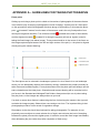
MERIT User Guide V2 WANT MORE INFORMATION? Click the Help link on the MERIT menu bar to read answers to frequently asked questions. Click the About link on the MERIT menu bar to read recent news and information on enhancements and fixes. The MERIT team also emails regular newsletters highlighting recent updates and future enhancements. Important news is also sometimes included in a pop-up box that appears when you log into MERIT. 90 MERIT User Guide V2 GLOSSARY OF TERMS Activity: an action that is undertaken to achieve project outputs and outcomes. Refer to the Activity Ready Reckoner for the list of activities and definitions. Activity Family Tree: a one-page table demonstrating the temporal relationship between activities. Commence reading the table from the centre ‘Primary Activity’ column. Activities to the left are those you may choose in preparation for the primary activity, including baseline data collection. Activities to the right are those you may choose for monitoring/maintenance of the activity, including comparison to baseline data. Administrator: is a level of access in MERIT which enables you to view all information for your project; input, edit and submit project data and reporting to the Department; and assign access permissions to other people (e.g. project managers, sub-contractors). Appropriateness: a determination made through comparing the programme with the needs of the intended beneficiaries using any of the techniques of needs analysis. Alternatively, a programme could be evaluated in terms of its compliance with process. Department: is the Australian Government Department of the Environment. Description (activity): is the description of an activity that you identified in the activity schedule of your MERI plan. The activity description appears in the ‘description’ column of the ‘Activities’ tab of your project page in MERIT. Description (project): is the description of your project, which you provided in your project application. The project description appears on the ‘overview’ tab of a project page in MERIT. Editor: is a level of access in MERIT, which enables you to view all information for a project; input and edit activity data and reporting. It does not allow you to submit project data and reporting to the Department or assign access permissions to other people. Effectiveness: a measure of the extent to which a programme, project or initiative has attained, or is expected to attain, its relevant objectives efficiently and in a sustainable way. Efficiency: the notion of getting the highest value out of programme or project resources. Favourites: are projects which you are interested in and have selected by clicking the ‘Add to favourites’ button in the top right of a project page in MERIT. Your favourite projects can then be accessed by clicking the ‘My projects’ button in the top right of the screen when you are logged in to your profile. Funding recipient (grant recipient): is an individual or organisation that has received funding for a project through an Australian Government NRM programme. 91 MERIT User Guide V2 Grant manager (case manager): is a Departmental officer that manages projects funded by Australian Government NRM programmes in cooperation with the funding recipient. Impact: a change in the condition of biophysical, social or economic and/or institutional assets. An impact may be positive or negative, primary or secondary, short term or long term, direct or indirect, and/or intended or unintended. Impacts are sometime realised after the formal project is completed. MERI: Simple concepts that, when applied, help us understand what is being achieved and help identify possible improvements, for projects and programmes: Monitoring: the collection of data and information. Evaluation: analysing the monitoring data and assessing what it means. Based on this, informed judgements can be made about the success of a project or programme and improvements can be identified. Reporting: communicating what we have found out through monitoring and evaluation. It is about sharing information, including about achievements and lessons learnt. Improvement: using this information to improve the way things are done. NRM programme: refers to Australian Government funded NRM programmes, such as National Landcare Programme. Outcomes: are the tangible and measurable changes resulting from maintenance of and/or improvement in NRM assets (e.g. vegetation condition change, recovery of threatened species). These may be immediate, intermediate or longer-term outcomes. Outputs: also referred to as ‘deliverables’, are the tangible (measurable and practical), immediate and intended results to be produced through NRM investment (e.g. area (ha) of revegetation completed, number of stakeholder engagement sessions held). Output Targets: are the total project outputs that a project has committed to achieve. These are captured from your MERI plan and displayed at the bottom of the ‘Activities’ tab of a project page in MERIT. Participant: A person who attends an event or participates in an activity including employed and not employed people (unless otherwise specified). Point of Interest: is a marker for a specific geographic location which can be added through the ‘sites’ tab of a project page in MERIT or via an activity form (for photo points). Funding recipients can use this to mark a range of features which will be useful to them such as the location of specific plantings within a larger site or the location of threatened species. 92 MERIT User Guide V2 Project: included in MERIT are: an individual funded project under: - Caring for our Country Targeted Area Grants; - Caring for our Country Reef Rescue; - Caring for our Country Community Environment Grants; - Biodiversity Fund Round 1; - Biodiversity Fund Round 2; - Biodiversity Fund Investing in Tasmania’s Native Forests; - Biodiversity Fund Northern Australia Targeted Investment; - Green Army; - National Landcare Programme, and a sub-project funded under: - Caring for our Country Regional Delivery (sustainable environment). Project MERI plan: is a document prepared by funding recipients to clearly set out the project activities to be undertaken, and the intended outputs and outcomes of the project. Ready Reckoner: a three page summary table of each activity, minimum data requirement (mandatory fields), target measures (outputs) plus more. The Ready Reckoner can be accessed from the Project Documents on the MERIT Demonstrator Project Overview page or via the MERIT resources page on the National Landcare Programme website. Schema: Word document that contains every field, field type and mandatory fields for each activity form. It also lists the outputs that are currently used for reporting. The Schema can be accessed from the Project Documents on the MERIT Demonstrator Project Overview tab or via the MERIT resources page on the National Landcare Programme website. Site: is a defined geographic location relevant to a project. Sites can be defined using the mapping tools available in the ‘sites’ tab of a project page in MERIT. Funding recipients can create sites at their discretion which allow them to represent their project. In some instances, it may be preferable to identify a site as a whole project area, or alternatively as a number of more specific smaller areas. SMART: A mnemonic acronym, giving criteria to help in setting objectives: Specific: a specific goal has a much greater chance of being accomplished than a general goal. Consider who is involved, what do I want to accomplish, where is the activity happening, what is the timeframe, are there any requirements or constraints and the 93 MERIT User Guide V2 specific reasons, purpose or benefits of accomplishing the goal. For example, a general goal is ‘get in shape’, a specific goal is ‘join a health club and workout 3 days a week’. Measurable: establish set criteria for measuring progress toward the attainment of each goal you set. Consider how much, how many, how will I know when it is accomplished? Attainable: an attainable goal will usually answer the question ‘How’. A goal should be neither out of reach nor below standard performance, since these may be considered meaningless. Consider how can the goal be accomplished, how realistic is the goal based on other constraints? Realistic: a goal should be realistic and relevant. A goal that supports or is in alignment with other goals would be considered a relevant goal. Consider does this seem worthwhile, is this the right time, does this match our other efforts/needs, is it applicable in the current socio-economic environment? Time-bound: a goal should have a timeframe within which it should be accomplished. Stage: is a six-monthly time period which is used in MERI plans and MERIT to delineate activities for reporting purposes. Stages are identified in the left column of the activity schedule of MERI plans or in the left column of the ‘Activities’ tab of a project page in MERIT. In MERIT an activity is assigned to a stage based on the timeframe during which it is scheduled to occur. Stage Summary: a document that summarises key information on the activities and achievements within a stage. Status: is used in MERIT to identify and track progress of an activity. MERIT includes the following status options: Planned: an activity that has been included in the project MERI plan but has not yet been commenced Started: an activity that has been included in the project MERI plan, work on undertaking the activity has commenced and data entered into MERIT Finished: an activity that has been included in the project MERI plan and all necessary actions to complete the activity have been undertaken Deferred: an activity that has been included in the project MERI plan and was scheduled to occur within a specific stage, but will now occur in a later stage Cancelled: an activity that has been included in the project MERI plan and was scheduled to occur, but will no longer be undertaken as part of the project Submit for approval: sends a project’s MERI Plan, list of planned activities and output targets to the Grant Manager/s for approval. 94 MERIT User Guide V2 Submit Report: sends the data collected for the planned activities, undertaken in the current reporting period, to the project’s Grant Manager/s for approval. Themes: are programme- specific priorities for investment which are defined in the relevant programme guidelines. Acronyms ALA: Atlas of Living Australia DoE: Department of the Environment DSE/ha: Dry sheep equivalents per hectare (a measurement for sustainable carrying capacity of paddocks) LGA: local government area MERI: monitoring, evaluation, reporting and improvement MERIT: online monitoring, evaluation, reporting and improvement tool NRM: natural resource management 95 MERIT User Guide V2 APPENDIX A – GUIDELINES FOR TAKING PHOTOGRAPHS Photo point Setting up and using a photo point to obtain a time-series of photographs of the same feature is an effective way of keeping a photographic record of change. A photo point is a fixed point on the ground from which photographs are taken along a fixed bearing. In this case the photo point is located 5 metres from the start of the transect, and is the only fixed position from which plot images will be taken. The reference marker and the alignment marker (located at the start of the transect) (located 20 m along the transect) will act as ‘sighter’ posts for taking the fixed image (see below image). These posts should be in the centre of the frame so the image captures equal areas of the left and right sectors of the plot (i.e. the photo is aligned directly along the transect bearing). The fixed photo can be oriented in landscape or portrait. A rule of thumb is to use landscape where you can adequately capture the overstorey canopy, otherwise use portrait (normally for taller forest and woodland types). Future photos taken from the photo point will always use the same orientation as the initial photo. Orientation and transect bearing will be recorded on the pro forma in the Standard and Abridged Field Guides. Always stand (do not sit) when taking the plot photo, so that images are always taken at eye level. If a shrub or some other feature is obstructing the line of site along the transect, then ignore it and take the image anyway. Obstructions come and go over time. The important thing is that photographs provide a visual record of vegetation change. Disturbance to the site should be minimised for taking photographs. For example, do not physically remove objects to create a better line of sight, and minimise the level of trampling between the photo point and the sighter posts. It is best to record the fixed image immediately after delineating the plot, rather than after completion of field survey. 96 MERIT User Guide V2 Opportunistic photographs Taking field images of interest in addition to the fixed photograph is encouraged. These may include photographs of: - native plants and animals, - habitat features (e.g. hollow-bearing trees, bird nests, coarse woody debris), - weed infestation before and after intervention, - disturbance incidents (e.g. wind throw, floods), - ‘typical’ stands of the vegetation type in and around the plot, and - the surrounding landscape. The position of the photographer in relation to the transect (i.e. transect distance and perpendicular distance right or left) and the photo bearing should be recorded on the pro forma so that the feature can be revisited updated images possible recorded during future monitoring. Image nomenclature The image taken at the photo point should be named after the Project and Plot ID, with a prefix for the year in which it was undertaken, and a ‘P’ to indicate it is the standard plot photo. For example CFOC0208_Plot01_2012_P Additional images taken at other points in the plot, or perpendicular to the plot transect, should use the same nomenclature, but with a trailing number to show that it is an opportunistic rather than the standard image. i.e. CFOC0208_Plot01_2012_1; CFOC0208_Plot01_2012_2; CFOC0208_Plot01_2012_3 etc. Intervention-specific images taken at other photo points should use a similar naming convention so that images can be conveniently associated with the project ID, the intervention, and the year of sampling. 97