1
Land Victoria
- VicMap Property (Parcel and
Property Boundaries,
Cadastre map)
- VicMap Transportation
(Roads and Rails)
- VicMap Localities (Local
Government Areas)
- VicMap Hydro (Rivers,
Lakes, …)
- Post codes boundaries in the
study area
Australian Bureau
of Statistics
Department of
Human Services
- Mesh Blocks in Study Area
(Land use, No of
dwellings, Population …)
- Demographic and
Socioeconomic
Information extracted
from Census 2006 data
including: Age, Gender,
Income …
- Quick Stats
Victorian Government
Health Information
Better Heath
Channel
Descriptive Data
- Directory of services in the study area
- The Home & Community Care
Conversion/Mapping/Geo-coding
Data Format
Check
No
Conversion to
ESRI Shape file
Maps
Yes
GIS Platform
(ESRI ArcGIS 9.2)
Spatial/Non
Spatial Analysis
Reports
Kml /Kmz
(Google Earth)
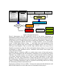
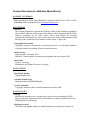
Figure1. Data preparation process
Figure1. demonstrates the data preparation process in the project. Department of
Sustainability and Environment (Land Victoria) was the main source of infrastructure and
administration boundaries information in the GIS system. Spatial information in the form
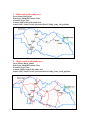
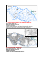
of GIS layers such as VicMap Property (Parcel and Property Boundaries, Cadastre map),
VicMap Transportation (Roads and Rails), VicMap Localities (Local Government
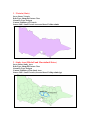
Areas), VicMap Hydro (Rivers, Lakes, …), and finally Post codes boundaries in the
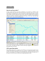
study area were obtained from Land Victoria in the MapInfo format. The conversion of
GIS layers from MapInfo (.Tab) to ArcGIS (.Shp) could be done in two ways, first in
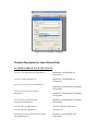
MapInfo environment by using The Universal Translator feature (Figure 2.) or in ArcGIS
environment by using extensions such as TabReader which allows direct import and
using Tab files in ArcGIS.
Australian Bureau of Statistics (ABS) was another major source of data in the project.
Most of the Demographic and Socioeconomic information were extracted from Census
2006 data. Age, Gender, Income, etc are the most common data that could be available at
ccd (census collection districts) level. Each ccd contain information of about 200
dwellings. The other major information available through ABS website was the Mesh
Block information. Mesh Blocks are more detailed units for data and each Block contains
around 50 dwellings information. Land use, population and dwelling numbers are among
the information provided in mesh block level.
Department of Human Services (DHS), Victorian Government Health Information and
Better Health Channel were also other sources of information in this project.