1
Python-FALL3D: User Manual
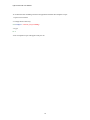
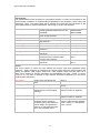
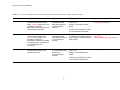
Table 3 – Description and input options (where applicable) for each input parameter in the python
script ‘create_hazard_map.py’
Input parameter
Description
Units/input options
Vent location in geographic coordinates (decimal degrees)
vent_easting
vent_northing
vent_zone
vent_hemisphere
Location of the vent.
Location of the vent.
UTM zone of the vent.
Hemisphere of the vent.
UTM coordinates
UTM coordinates
Options: N or S
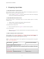
Values
Hazard maps are based on multiple scenarios and a specified threshold of volcanic ash
(kg/m2). The resulting maps contour the probability of exceeding that specified ash threshold
given the multiple scenarios. One map is produced for each threshold value.
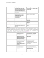
load_values
Volcanic ash load threshold values
(kg/m2) which will be used to
generate a hazard map.
A separate hazard map will be
generated for each load value.
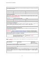
fl_values
Volcanic ash concentration
threshold values (kg/m3) which will
be used to generate a hazard map.
A separate hazard map will be
generated for each concentration
value.
Options: a single threshold value i.e.
0.1, or a list of thresholds values
separated by commas and enclosed
in square brackets i.e. [0.1, 10, 20].
The resulting map(s) will contour
probability of exceeding the ash load
threshold in %.
Options: a single threshold value i.e.
0.002 or a list of thresholds values
separated by commas and enclosed
in square brackets i.e. [0.0002,
0.002].
The resulting map(s) will contour
probability of exceeding the ash
concentration threshold in %.
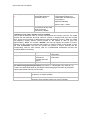
Contours
The model contours probability of exceedance (%) and/or change through time (hour) for
viewing in Google Earth and ArcGIS. There are four options for determining the interval
between contours: ‘True’, ‘False’, ‘Number’ or ‘List of numbers’ (Refer to Table 2).
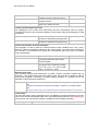
ISOCHRON_contours
Contour interval type.
ISOCHRON_units
PLOAD_contours
Contour units.
Contour interval type.
PLOAD_units
Contour units.
Options: True, False, Number or
List of Numbers
Units: hours
Options: True, False, Number or
List of Numbers
Units: percent
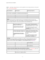
Location of generated windprofiles, hazard map and contours
This directory should contain the multiple scenario outputs produced by volcano.py which will
be used to create the hazard map(s). The hazard map(s) will be stored here.
model_output_directory
‘/<home>/<username>/<tephra>/<hazard_outputs>’
(a directory of multiple profiles)
17