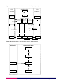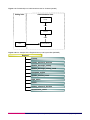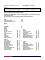
1
Boundary-Line
User guide
Contents
Section
Preface
Chapter 1
Chapter 2
Chapter 3
Page no
..................................................................................................................................................4
Contact details ..........................................................................................................................4
Use of the product.....................................................................................................................4
Purpose and disclaimer ............................................................................................................4
Copyright in this guide ..............................................................................................................4
Data copyright and other intellectual property rights ................................................................5
Trademarks ...............................................................................................................................5
Back-up provision of the product ..............................................................................................5
Using this guide.........................................................................................................................5
An introduction to Boundary-Line ........................................................................................6
Boundary-Line features.............................................................................................................6
Boundary-Line benefits .............................................................................................................7
Boundary-Line applications.......................................................................................................7
Boundary-Line files and sub-levels ...........................................................................................7
Requirements to utilise Boundary-Line.....................................................................................8
Hardware .............................................................................................................................8
Software...............................................................................................................................8
Transfer formats...................................................................................................................9
Media ...................................................................................................................................9
Update .................................................................................................................................9
Overview of Boundary-Line .................................................................................................10
Data overview .........................................................................................................................10
Basic principles ..................................................................................................................10
Boundary-Line data source................................................................................................10
Complex polygons .............................................................................................................10
Feature information............................................................................................................11
Feature position .................................................................................................................11
Feature attribute data.........................................................................................................12
Area codes.........................................................................................................................12
Other attributes ..................................................................................................................12
Unique identifiers for administrative unit, link and polygon................................................12
Text ....................................................................................................................................12
Boundary-Line explained .....................................................................................................13
Relationships of administrative areas .....................................................................................13
Boundary-Line principles and features ...................................................................................17
Administrative area ............................................................................................................17
Area values ........................................................................................................................17
Boundary............................................................................................................................18
Ceremonial counties ..........................................................................................................18
Detached parts...................................................................................................................18
Divorcement.......................................................................................................................18
Effective date .....................................................................................................................18
Exception areas .................................................................................................................19
Honorary titles....................................................................................................................20
National boundaries ...........................................................................................................21
Census agency codes .......................................................................................................21
Un-annexed areas .............................................................................................................22
Unitary authorities ..............................................................................................................22
The coastline and associated items........................................................................................22
Extent of the realm (EOR) .................................................................................................22
Foreshore...........................................................................................................................23
Islands and rocks in the sea ..............................................................................................23
Mean high water (springs) .................................................................................................24
Mean low water (springs)...................................................................................................24
Boundary-Line user guide contents v1.0 – 04/2007 © Crown copyright Page 2 of 75
Annexe A
Annexe B
Normal tidal limit (NTL) ......................................................................................................24
Pier.....................................................................................................................................24
Point B ...............................................................................................................................24
Seaward extensions...........................................................................................................24
Structures in the sea ..........................................................................................................25
Change update: Statutory Instruments (SI) and non-SI changes in May 2007 –
Boundary-Line release .........................................................................................................26
England ...................................................................................................................................26
Wales ......................................................................................................................................27
Scotland ..................................................................................................................................27
Product and service performance report form ..................................................................29
v1.0 – 04/2007
Boundary-Line user guide contents v1.0 – 04/2007 © Crown copyright Page 3 of 75
Preface
This user guide (hereafter referred to as the guide) is designed to provide an overview of Boundary Line™
(hereafter referred to as the product) and it gives guidelines and advice on how a customer might derive the
maximum benefit from the product. It assumes a general knowledge of geographic information. If you find an
error or omission in this guide, or otherwise wish to make a comment or suggestion as to how we can
improve the guide, please contact us at the address shown below under contact details or complete the
product and service performance report form at annexe B and return it to us.
Contact details
Our Customer Service Centre will be pleased to deal with your enquiries:
Customer Service Centre
Ordnance Survey
Romsey Road
SOUTHAMPTON
SO16 4GU
Business enquiries: +44 (0) 23 8030 5030
General enquiries (calls charged at local rate): 08456 05 05 05
Dedicated Welsh Language HelpLine: 08456 05 05 04
Textphone (deaf and hard of hearing users only please): +44 (0) 23 8079 2906
Email: [email protected]
or visit the Ordnance Survey website at: www.ordnancesurvey.co.uk
Use of the product
The terms and conditions upon which the product, including this guide, is made available to you and your
organisation are contained in the customer contract made between you and Ordnance Survey. If there is an
inconsistency between the terms of your customer contract and this guide, then the terms of your customer
contract prevail. If you or your organisation has not signed a valid current customer contract then you are not
entitled to use the product.
Purpose and disclaimer
This guide is provided for guidance only and does not constitute any warranty, representation, undertaking,
commitment or obligation (express or implied) about the product or its suitability for any particular or intended
purpose. Any warranties, representations, undertakings, commitments and obligations given by
Ordnance Survey about the product and/or its suitability for any particular or intended purpose are set out in
your customer contract. It is your responsibility to ensure that this product is suitable for your intended
purpose.
Ordnance Survey does not accept any liability (whether for breach of contract, negligence or otherwise) for
any loss or liability you or any third party may suffer in relying on this guide and any guidance, suggestion,
advice or explanation provided in it. Any liability that Ordnance Survey has to you in relation to the product,
its supply, use, accuracy, data supplied, functionality or any other liability arising out of or in connection with
the product is limited as set out in your customer contract.
We may change the information in this guide at any time without notice.
We do not accept responsibility for the content of any third party websites referenced or accessed in or
through this guide, any contractual documentation, and/or the Ordnance Survey website.
Copyright in this guide
This guide (including for the avoidance of doubt any mapping images reproduced herein), is
© Crown copyright 2007. All rights reserved.
Any part of this guide may be copied for use internally in your organisation or business so that you can use
the product for the purpose for which it is licensed to your organisation or business (but not otherwise).
Boundary-Line user guide preface v1.0 – 04/2007 © Crown copyright Page 4 of 75
No part of this guide may be reproduced or transmitted in any form or by any means (including electronically)
for commercial exploitation without the prior written consent of Ordnance Survey.
No part of this guide may be copied or incorporated in products, services or publications that you generate
for onward sale, or as free promotional or support materials, without the prior written consent of
Ordnance Survey.
Data copyright and other intellectual property rights
The Crown (or, where applicable, Ordnance Survey’s suppliers) owns the intellectual property rights in
Ordnance Survey digital map data.
Full details of the terms and conditions under which Ordnance Survey digital map data may be processed
and/or manipulated or copied by a customer – whether or not for use on PCs or workstations or for making
hard copies – are available from the Customer Service Centre, please see contact details. You should check
the terms and conditions with us before using the data. It is also the responsibility of the holder of the digital
map data to ensure that any plotted or printed output contains the required copyright and database
acknowledgements in a conspicuous position.
Trademarks
Ordnance Survey, the OS Symbol, Land-Line, Landplan and OSGB36 are registered trademarks and
Boundary-Line is a trademark of Ordnance Survey, the national mapping agency of Great Britain.
Free Adobe and Acrobat Reader are registered trademarks of Adobe Systems Incorporated.
ESRI are registered trademarks of Environmental Systems Research Institute, Inc.
MapInfo is a registered traemark of MapInfo Corporation.
Back-up provision of the product
You are advised to copy the supplied data to a back-up medium.
Using this guide
The documentation is supplied in portable document format (PDF) only. Free Adobe® Acrobat Reader®
software, which displays the guide, incorporates search and zoom facilities and allows you to navigate
within. Hyperlinks are used to navigate between associated parts of the guide and to relevant Internet
resources by clicking on the blue hyperlinks and the table of contents.
If you are unfamiliar with any words or terms used and require clarification please refer to the glossary at the
end of the document.
Boundary-Line user guide preface v1.0 – 04/2007 © Crown copyright Page 5 of 75
Chapter 1
An introduction to Boundary-Line
This user guide is an introduction to Boundary-Line which offers guidance and advice on how to deliver the
maximum value from the product. The technical specification provides specific details of the structure,
content and formats of Boundary-Line for customers using the data in a geographical information
system (GIS) or other systems. The technical specification should be used in conjunction with the user
guide.
Boundary-Line provides administrative and electoral boundaries and their names for England, Scotland and
Wales. Boundary-Line represents the hierarchy of boundaries in Great Britain.
Boundary-Line for England and Wales was initially digitised from Ordnance Survey’s boundary record sheets
at 1:10 000 scale (or, in some cases, at 1:10 560 scale).
The 1:10 000 scale published mapping has being progressively withdrawn as it is replaced by Landplan®.
Boundary-Line now uses this as the source document, occasionally mapped against large scale source.
The census agency codes are supplied by Office of National Statistics (ONS) and General Registers of
Scotland (GROS).
Appropriate software is needed to use the data for your intended application.
Update notes, detailing previous release changes, accompany each product release contained within the
.doc file on the CD and the Change Update document.
Subject to payment of the annual licence fee, you will be provided with a replacement dataset for all
Boundary-Line files, supplied in accordance with your licensing agreement.
Boundary-Line features
A list of the features within Boundary-Line includes:
• civil parish (England) and community (Wales);
• county;
• district;
• metropolitan district;
• electoral division (county and unitary);
• European Electoral region;
• Greater London Authority;
• London borough (including the county of the City of London);
• Greater London Authority Assembly constituencies (the London Proportional Representation voting areas);
• metropolitan district;
• parliamentary (Westminster) constituency;
• parliamentary (Scottish) constituency and electoral region;
• unitary authority;
• ward (district, unitary, metropolitan and London borough);
• Welsh Assembly constituency and electoral region;
• extent of the realm (EOR) – either mean low water mark (England and Wales), mean low water springs
mark (Scotland) or seaward boundary extensions;
• mean high water mark (England and Wales) and/or mean high water springs mark (Scotland) (both are
abbreviated to MHW in this user guide);
• distinctive names;
• census agency codes in England, Wales and Scotland for counties, unitary authorities, districts, wards
and electoral divisions;
• area measurements;
• unique administrative unit, link and polygon identifiers; and
• annual updates of the dataset.
Boundary-Line user guide chapter 1 v1.0 – 04/2007 © Crown copyright Page 6 of 75
Boundary-Line benefits
The high specification of Boundary-Line offers you a number of benefits:
• Full coverage of Great Britain, supplied as England, Scotland and Wales
• The key boundary dataset for Great Britain suited to multiple applications using a geographical
information system (GIS) and other digital mapping systems.
• The full hierarchy of boundaries.
• Structured vector format, offering great functionality.
• census agency codes (where available) allow you to link Boundary-Line polygons with census statistics.
• Area values for every polygon.
• Mean high water (springs) mark enables you to build and explicitly identify dry land areas within coastal
polygons.
• Documented annual updates allow you to easily identify relevant changes.
• Unique administrative area identifiers are retained at each update, allowing revised boundaries to be
related to your existing data.
Boundary-Line applications
Boundary-Line provides a detailed and comprehensive dataset of coverage in Great Britain of administrative
and voting boundaries that is designed to support a wide range of GIS and desktop mapping applications,
such as:
• political analysis;
• planning applications;
• environmental analysis;
• legal work;
• statistical analysis for social or marketing decision making;
• reference and research; or
• geodemographic analysis;
• customised graphic output.
• asset management;
Boundary-Line files and sub-levels
The data is supplied as named files. The named files include all of the other relevant sub-levels of electoral
boundaries that belong under that high level administration; these are:
Named file type
Possible sub-level of boundaries within the named file
County
The named county, district, district ward, civil parish,
county electoral division (ED).
Unitary authority
The named unitary authority, unitary authority ward or unitary
authority ED as appropriate, civil parish where appropriate, together
with community in Wales.
Metropolitan district
The named metropolitan district, metropolitan district ward, civil
parish where appropriate.
Greater London Authority
The Greater London Authority, Greater London Authority Assembly
constituency, London borough, London borough ward.
Scottish parliamentary electoral region The named Scottish parliamentary electoral region, Scottish
parliamentary constituency.
Welsh assembly electoral region
The named Welsh Assembly electoral region, Welsh Assembly
constituency.
Westminster constituency
The named Westminster constituency.
European region
The named European region.
Boundary-Line user guide chapter 1 v1.0 – 04/2007 © Crown copyright Page 7 of 75
The following table represent the named files contained in Boundary-Line NTF May 2006 specification:
• A complete dataset of Great Britain has 824 named files made up of:
• 35 county files;
• 100 unitary authority files;
• 628 Westminster constituency files;
• 11 European region files;
• 36 metropolitan district files;
• 1 Greater London Authority file;
• 8 Scottish parliamentary electoral region files; and
• 5 Welsh Assembly electoral region files.
• The dataset for England has 656 named files made up of:
• 35 county files;
• 46 unitary files;
• 529 Westminster constituency files;
• 9 European region files;
• 36 metropolitan district files; and
• 1 Greater London Authority file.
• The dataset for Wales has 68 named files made up of:
• 22 unitary authority files;
• 40 Westminster constituency files
• 1 European region file; and
• 5 Welsh Assembly electoral region files (these include the Welsh Parliamentary files).
• The dataset for Scotland has named files made up of:
• 32 unitary authority files;
• 59 Westminster constituency files;
• 1 European region file; and
• 8 Scottish parliamentary electoral region files (these include the Scottish Parliamentary files).
As a consequence of the named file supply, all coordinates in the supplied data file are full Ordnance Survey
National Grid coordinates, as there is no concept of local origin.
Requirements to utilise Boundary-Line
Hardware
Provided that sufficient memory, storage facilities and a suitable software viewer application (see below) are
available, there are no constraints on the hardware platforms that can be used. The range of hardware that
can typically be used varies from higher specification personal computers (PCs) to mainframe computers.
Software
Boundary-Line is inert data and does not include software for data manipulation. To fully exploit Boundary-Line
it is necessary to use appropriate application software. There are many proprietary systems available and
Ordnance Survey publishes a list of GIS, computer-aided design (CAD) and digital mapping system suppliers
who have independently confirmed their software can import Ordnance Survey NTF format data.
Boundary-Line user guide chapter 1 v1.0 – 04/2007 © Crown copyright Page 8 of 75
Transfer formats
Boundary-Line is created in:
• BS 7567 (NTF v2.0 Level 3)
• ESRI® Shapefile
• MapInfo® MID/MIF
Media
Boundary-Line is supplied on CD-ROM.
Update
Boundary-Line is now updated twice a year, spring and autumn, allowing a choice in which update is
preferred
The spring update represents boundaries (as defined and modified by Orders, Acts and Statutory
Instruments) at the date of the May local elections.
The autumn update also represents boundaries at the date of the May local elections and is operative from
the previous spring/May to autumn/October release.
Each update is accompanied by details of all changes.
Boundary-Line user guide chapter 1 v1.0 – 04/2007 © Crown copyright Page 9 of 75
Chapter 2
Overview of Boundary-Line
Data overview
Basic principles
Boundary-Line is the key dataset of administrative and voting boundaries in Great Britain. It is a
representation in computer-readable form of a specialist large-scale map, including real-world objects, which
may be tangible (such as the mean high water mark) or intangible (such as a district boundary).
GIS software provides the functionality to store, manage and manipulate this digital map data. The properties
of the data make it suitable as a key base for users wishing to develop applications. Boundary-Line is also
suitable for use within other digital mapping systems. Boundary-Line is coordinated on the National Grid,
which allows for the easy superimposition of other datasets.
Links represent all linear features; that is boundaries, extent of the realm (EOR), and mean high water
(springs) mark (MHW). They are strings of coordinated line segments and have relationships to polygon
features in order to convey descriptive characteristics of the link. Links in Boundary-Line may comprise up to
several thousand line segments. A chain is the closed loop of links bounding a polygon.
Nodes are the representation of the points at the start and end of a link. At least one node occurs on the
perimeter of a polygon where the bounding link completes the enclosure of the area. There may be many
nodes connecting the bounding links of a polygon. Nodes are implicit in Boundary-Line.
Polygons are continuous areas defined by sets of bounding closed lines. They are representational of
areas, such as electoral wards, and have relationships to administration collection features in order to
convey descriptive characteristics of the polygon. These are explicit within the data and can be viewed and
manipulated with appropriate software
Each link feature has associated geometry; this will be two or more coordinate pairs.
Boundary-Line data source
Boundary-Line is currently updated by mapping against Landplan (1:10 000 scale) and in certain cases large
scale sources.
Complex polygons
Complex polygons are polygons that wholly enclose other polygons. They only occur when an administrative
unit wholly encloses one or more others at the same level, for example, a rural district surrounding an urban
district.
Boundary-Line user guide chapter 2 v1.0 – 04/2007 © Crown copyright Page 10 of 75
Figure 2.1: A complex polygon – Cambridge District surrounded by South Cambridgeshire District
Feature information
Boundary-Line has three feature classes:
• administrative units with attributes;
• polygon features with attributes; and
• linear features – links with attributes and geometry.
The position and shape of real-world features are represented in Boundary-Line data as geometric structures
of links. They are arranged into recognisable categories. Full listings of individual features are listed in
chapter 2 of the technical specification, Specific Boundary-Line NTF Information.
Each feature has the following component:
• feature attribute data.
Each geometric feature has an additional component:
• feature position.
Each link has a geometric and attribute component. The geometric component defines the positional
characteristic of the feature, and explicit relationships exist between administrative units and polygons and
the links and polygons. The attribute component defines the descriptive characteristics of the feature,
together with the classification.
Feature position
The geometry of map features is defined in terms of coordinates. All coordinates used in Boundary-Line are
based on the Ordnance Survey National Grid (NG) coordinate referencing system and are quoted to a 0.1 m
resolution. Despite this, Boundary-Line data can be no more accurate than its source, primarily the
generalised 1:10 000 scale mapping. There will be positional differences between the boundaries in
Boundary-Line and Ordnance Survey large-scale topographic products. This is due to the large-scale
products being surveyed to a higher degree of accuracy and associated to ground surface features, at scales
such as 1:1250 and 1:2500.
Boundary-Line user guide chapter 2 v1.0 – 04/2007 © Crown copyright Page 11 of 75
Boundary-Line has been created as a more generalised set of administrative and electoral boundaries for
the whole of Great Britain. It has been digitised against Ordnance Survey (generalised) 1:10 000 Landplan
mapping. The process of generalising for 1:10 000 scale mapping may have caused certain features to be
moved from their true ground position for the purposes of map clarity. The result being Boundary-Line and
large-scale boundaries will not always be coincident.
Feature attribute data
An attribute is the descriptive characteristic of a feature, that is, a non-spatial element. In Ordnance Survey
map data terms, an attribute can be a feature type (these are character codes), or a distinctive name,
number or code, for example, Bassett ward or 145.232 hectares.
Attribute codes relevant to NTF are fully described in chapter 4 of the technical specification.
Area codes
Each administrative unit is classified by means of an area code (AC). These area codes are allocated when
each feature is initially interpreted and captured from source. This means that a county is distinguished from
a ward by the area code allocated to it. The polygon features can be classified by tracing their relationships
to administrative units. Consequently links can be classified by tracing their relationships to polygons. These
area codes are all listed in chapter 2 of the technical specification.
Other attributes
It is possible, with appropriate software, for you to add other names or values of your own choice as
attributes of features.
Unique identifiers for administrative unit, link and polygon
There are three identifiers in Boundary-Line that help you identify features and which are provided to create
consistent references between successive releases of Boundary-Line data. They are unique within each
feature type throughout the whole dataset and maintained through successive annual updates. See
chapter 2 in the technical specification for Other attributes and ID information. These identifiers are never
modified – only created or deleted. If a feature is deleted from the Boundary-Line database, then the
identifier ceases to exist.
ADMIN_AREA_ID (AI)
GLOBAL_LINK_ID (LK)
GLOBAL_POLYGON_ID (PI)
Text
There is no direct cartographic text in Boundary-Line. Names, area values and census agency codes are
held as attributes.
Boundary-Line user guide chapter 2 v1.0 – 04/2007 © Crown copyright Page 12 of 75
Chapter 3
Boundary-Line explained
Relationships of administrative areas
The Boundary-Line product supplies the administrative area relationships explicitly within the [COLLECT]
record.
A district is a division of a county; a civil parish is a division of a district. A county is divided for voting
purposes into Electoral Divisions (EDs) and a district is divided for voting purposes into district wards.
With the introduction of unitary authorities, there are now two- and three-tier local government hierarchies.
The three-tier system remains unchanged; the two-tier system has unitary authorities replacing the county
and district levels of administration.
Unitary authorities may be divided into civil parishes or communities (except in Scotland); and unitary
authority wards or unitary authority EDs for voting purposes. In Wales the voting area is the unitary authority
ED; in Scotland it is the unitary authority ward, and in England it is the unitary authority ward (except in the
Isle of Wight, where it is the unitary authority ED).
England also has metropolitan districts; these have no county administration. These districts are divided for
voting purposes into metropolitan district wards.
With the introduction of the regional government for London, in this document called the Greater London
Authority; the proportional representation voting area for this new administration is the Greater London
Authority Assembly constituency. The existing London borough structure also has a relationship with the new
Greater London Authority and each London borough is divided for voting purposes into London borough
wards.
Scotland is divided into parliamentary constituencies for voting purposes; to elect Members of the Scottish
Parliament (MSPs).The Scottish parliamentary electoral region is a grouping of Scottish parliamentary
constituencies.
Wales is divided into assembly constituencies for voting purposes; to elect Assembly Members (AMs) to the
Welsh Assembly. The Welsh Assembly electoral region is a grouping of Welsh Assembly constituencies.
Great Britain is divided into European regions (Scotland, Wales and nine English regions) for voting
purposes to elect members (MEPs) to the European parliament.
England, Scotland and Wales are divided into parliamentary constituencies for voting purposes to elect
members (MPs) to the Westminster parliament. Parliamentary constituencies are made up of combinations
of Wards (or Electoral Divisions in Wales).
Boundary-Line data is output in two structures:
• Nested
The data is supplied by named files, all the named files include all of the other sub-levels of electoral
boundaries that belong under that high level administration (for example, County file) will have the named
county, district, district ward, civil parish, county ED contained within. Unitary authorities will have named
unitary authority, unitary authority ward or unitary authority ED as appropriate, civil parish where
appropriate, together with community in Wales. The nested structure is available in NTF, ESRI Shapefile
and MapInfo MID/MIF.
• Layered
This is a simplified file structure supplying the boundaries as individual files, for example, County file
contains only counties, and unitary authorities file contains just unitary authorities. The layered structure
is only available in ESRI Shapefile and MapInfo MID/MIF.
Boundary-Line user guide chapter 3 v1.0 – 04/2007 © Crown copyright Page 13 of 75
Figure 3.1a: Relationships of administrative areas for England (nested)
Administrative Area
Local
Government
Voting Area
Local
Government
Voting Area
Europe
Nested
England
Electoral Division
(Isle of Wight only)
Nested
Electoral Division
Nested
Unitary Authority
(parts of England)*
London Boroughs
& Metropolitan
District (parts of
Nested
County
(parts of England)
England)
Nested
Ward
Ward
Nested
(except Isle of Wight)
District*
Nested
*NOTE: Some Dist's/UA's have
or are non-Parished Areas
Ward
Nested
Nested
Nested
Nested
Civil Parish
(some Metropolitan
Districts only)
Civil Parish
Civil Parish
Nested
Ward
Nested
Figure 3.1b: Relationships of administrative areas for Wales (nested)
Voting Area
Administrative Area
Europe
Nested
Wales
Nested
Electoral Division
Unitary Authority
Nested
Community Ward
Community
Boundary-Line user guide chapter 3 v1.0 – 04/2007 © Crown copyright Page 14 of 75
Figure 3.1c: Relationships of administrative areas for Scotland (nested)
Voting Area
Administrative Area
Europe
Nested
Scotland
Nested
Ward
Unitary Authority
Figure 3.2a: An example of the English directory and layered files (MID/MIF)
England
County
county_electoral_division
district_borough_unitary
district_borough_unitary_ward
european_region
greater_london_const
high_water
parish
unitary_electoral_division
westminster_const
Boundary-Line user guide chapter 3 v1.0 – 04/2007 © Crown copyright Page 15 of 75
Figure 3.2b: An example of the Scottish directory and layered files (MID/MIF)
Scotland
district_borough_unitary
district_borough_unitary_ward
european_region
high_water
parish
scotland_and_wales_const * (see note)
scotland_and_wales_region * (see note)
westminster_const
NOTE:*Scotland_and_Wales files contain only Scottish information in the Scotland data folder and only
Welsh information in the Wales data folder.
Figure 3.2c: An example of the Welsh directory and layered files (MID/MIF)
Wales
district_borough_unitary
european_region
high_water
parish
scotland_and_wales_const * (see note)
scotland_and_wales_region * (see note)
unitary_electoral_division
westminster_const
NOTE: *Scotland_and_wales files contain only Scottish information in the Scotland data folder and only
Welsh information in the Wales data folder.
Boundary-Line user guide chapter 3 v1.0 – 04/2007 © Crown copyright Page 16 of 75
Boundary-Line principles and features
This following explains the representation of features in Boundary-Line and describes various definitions and
exceptions.
Administrative area
A term used by Ordnance Survey to refer to all public administrative areas. For the Boundary-Line dataset
the following are included under this term:
• In England:
• county;
• unitary authority;
• metropolitan district;
• district;
• civil parish (NOTE: depicted if appropriate notification has been received. Not all parishes have
councils);
• Isles of Scilly;
• European Electoral region;
• parliamentary (Westminster) constituency;
• electoral division (of county or unitary authority);
• ward (of district, metropolitan district, London borough, unitary authority);
• London borough (including the county of the City of London);
• Greater London Authority; and
• Greater London Authority Assembly constituency.
• In Wales:
• unitary authority;
• community (NOTE: depicted if appropriate notification has been received);
• European Electoral region;
• parliamentary (Westminster) constituency;
• electoral division (of unitary authority);
• Welsh Assembly constituency; and
• Welsh Assembly electoral region.
• In Scotland:
• unitary authority;
• European Electoral region;
• parliamentary (Westminster) constituency;
• ward (of unitary authority);
• Scottish parliamentary constituency; and
• Scottish Parliament electoral region.
Area values
Area values exist for every polygon in Boundary-Line, area values are quoted to the current Department for
Communities and Local Government (DCLG) specification of 0.001 hectare. The value is subject to the
inherited accuracies of the generalised 1:10 000 scale published mapping used as the source for
Boundary-Line.
Boundary-Line user guide chapter 3 v1.0 – 04/2007 © Crown copyright Page 17 of 75
Boundary
A boundary is the limit of a preset and established area whose limit is determined by one or more lines. For
example in Boundary-Line an administrative unit boundary, is represented by a county area boundary.
Ceremonial counties
A ceremonial county is an area that has an appointed Lord Lieutenant and High Sheriff.
Ceremonial counties are not explicitly represented in Boundary-Line.
Detached parts
The description Detached, (Det), only applies to portions of local government or parliamentary constituency
areas which are separated from the main area, being completely surrounded by other local government or
parliamentary constituency areas and not connected by direct access on the ground.
The description will not be applied to islands or parts of islands in the sea.
Detached parts have the same AI attribute (and census agency code where applicable) as the main area.
Where there is more than one detached part they are numbered consecutively within the name, for example,
MILTON CP (Det No 1).
Divorcement
Part of a boundary separated from another, originally on the same alignment. Divorcements are created by
the revision of one boundary and not the other.
Figure 3.3: Divorced boundaries
Figure 3.3 shows a boundary divorcement. The unitary boundary between Vale of Glamorgan and Cardiff
has been realigned, whilst the parliamentary (Westminster) constituency boundary has remained in its
original position. It is likely that the parliamentary (Westminster) constituency boundary will also be realigned
at some time in the future.
Effective date
A future event of unknown date, for example, the next general election, at which time the changes specified
in an Act, Order or Statutory Instrument will come into operation. This term is solely applied to parliamentary
(Westminster) and European region boundaries.
Boundary changes are not incorporated into Boundary-Line unless they have become operative at the time
of the annual snapshot of boundaries that each release of Boundary-Line represents.
Because of this, parliamentary constituencies and European regions in Boundary-Line are normally those in
which the MPs, AMs, MEP’s and MSP’s are or were sitting at the time of the annual snapshot of boundaries
that each release of Boundary-Line represents.
For example, the new Scottish Westminster parliamentary constituency boundaries which became effective
at the time of the May 2005 general election were first represented in the October 2005 Boundary-Line
release.
Boundary-Line user guide chapter 3 v1.0 – 04/2007 © Crown copyright Page 18 of 75
Exception areas
The following are specific exceptions to the normal rules:
Greater London and the metropolitan counties
• Greater London covers the area of the 32 London Boroughs plus the City and County of the City of
London.
• Greater London is no longer a County. The Greater London Authority, which has no authority over the
autonomous London Boroughs, is held as one named file with all of the sub-levels of boundary within it.
• The London Boroughs and the City and County of the City of London have been classified as London
Boroughs.
The Metropolitan Districts within the former Metropolitan Counties (disbanded in 1985) are classified as
Metropolitan Districts:
• Greater Manchester;
• Merseyside;
• South Yorkshire;
• West Yorkshire;
• Tyne and Wear; and
• West Midlands.
The Inner and Middle Temples
The ‘places’ known as ‘The Inner and Middle Temples’ are within the City of London only for some purposes.
They are not shown in Boundary-Line, but their areas have been wholly included within the City and its
Wards for this dataset. There are two distinct areas with other areas held jointly, and the boundaries are so
intermixed that they have never been published by Ordnance Survey separately. A record of these
boundaries is, however, held in the Boundary Record Library for reference purposes.
Isles of Scilly
The Isles of Scilly are administered by a single-tier authority, the ‘Council of The Isles of Scilly’, and are not
part of the County of Cornwall although linked with it for some purposes.
For the purposes of this dataset however it is classified as a County. There are no Districts, Electoral
Divisions or Wards within this area.
Parish/Community Wards
Divisions of parishes (England) and communities (Wales) not included in Boundary-Line.
Lands common to
These are areas where the limits of the parishes concerned have not been determined and the area itself is
common to (or belongs to) two or more parishes. In Boundary-Line they are classified as separate parishes
with the name LANDS COMMON TO THE PARISHES OF____ applied (sometimes abbreviated to
LCPs___). These areas are allocated their own AI attributes and so on.
Boundary-Line user guide chapter 3 v1.0 – 04/2007 © Crown copyright Page 19 of 75
Figure 3.4: An example of Lands common to
River Dee
The boundary between Merseyside (the former county of) and the county of Cheshire and the Flintshire
unitary authority area has not been determined and the line adopted in Boundary-Line is for the purposes of
Ordnance Survey only, so that polygons can be created.
River Mersey
Certain sections of the boundary between Merseyside (the former county of); the county of Cheshire and the
districts of Liverpool, Wirral, Ellesmere Port and Neston, Vale Royal and Halton have never been
determined.
For the purposes of Boundary-Line, and by agreement with DCLG:
1 the district boundaries of those parts of Ellesmere Port and Neston, Vale Royal and Halton that abut the
Mersey estuary have been made coincident with the limits of the relevant district’s wards at the centre of
the channel at high water (CCHW);
2 the undetermined part of the southern boundary of Liverpool district, in the Mersey estuary, has been
made coincident with the limits of that district’s wards at the centre of the channel at high water (CCHW);
3 the undetermined part of the county boundary between Merseyside (the former county of) and Cheshire
in that part of the estuary between the districts of Ellesmere Port and Neston and Liverpool has been
made coincident with the limits of the electoral divisions at the centre of the channel at high water
(CCHW); and
4 the northern limit of the parliamentary constituency of Ellesmere Port and Neston is the mean high water
mark on the south side of the Mersey estuary.
The wards of Windsor Castle
The Upper and Middle wards of Windsor Castle do not form part of the district of Windsor and Maidenhead
but have been included for the purposes of this dataset.
Honorary titles
Honorary titles granted to local government areas, such as city and town are not included in Boundary-Line.
Boroughs in England have been identified, as from the October 2006 release, with _(B) in the file name and
(B ) in the Name attribute, for example;
CITY_OF_ SOUTHAMPTON_(B)
= File name
CITY OF SOUTHAMPTON (B)
= NAME attribute
The borough (B) will only be depicted on Unitary Authorities, District and Metropolitan Districts. A list of these
boundaries and their borough status will be provided in the Doc Folder of the Boundary-Line product CD.
This addition is to purely denote which boundaries have Borough status in England without creating
polygons or altering the specification in any way.
Boundary-Line user guide chapter 3 v1.0 – 04/2007 © Crown copyright Page 20 of 75
National boundaries
The boundaries between England and Wales and England and Scotland are treated as county boundaries in
Boundary-Line which have been created from the local authority boundaries.
Census agency codes
These codes are a unique system of referencing for administrative units.
The following types of unit are coded in Boundary-Line where they have been made available: counties,
districts, metropolitan districts, London boroughs, unitary authorities, district wards, unitary authority wards
and unitary authority EDs.
The codes are allocated by the Office of National Statistics (ONS) for England and Wales and by the
General Register Office for Scotland (GROS) for Scottish areas.
NOTES: The codes for Scotland were included for the first time in the 1997 release of Boundary-Line. The
NTF OP record has a maximum of seven characters for the census codes. In three-tier local government
hierarchy areas, the format of the codes is a combination of two digits for county and two letters each for
district and ward, in the form CCDDWW (see the following example codes) or CCDDPAR for Parish census
agency code.
Example codes for typical wards in Cheshire
13UBGU
(College ward)
13UHGY
(Helsby ward)
13UDGH
(Birchin ward).
The code for a county consists of the first two characters, followed by four spaces.
Example code for a county
13
(Cheshire)
The code for a district consists of the first four characters, followed by two spaces:
Example code for a typical district
13UB
(13 = Cheshire county and UB = Chester district)
In two-tier local government hierarchy areas, the format of the codes is four letters, followed by two spaces,
where the first two letters represent the unitary authority, and the second two, the ward.
Example code for a sample ward in a unitary authority
ETMA (ET = Halton and MA = Halton Brook ward)
The code for a unitary authority area consists of the first two characters, followed by four spaces.
Example code for a unitary authority
NJ
(Sir y Fflint – Flintshire)
Any OP code is set at 999999 when the information is not available to Ordnance Survey.
The code is blank when the administrative unit does not have a code.
The Isles of Scilly have a unitary council but is considered as a district of the county of 'Cornwall and the
Isles of Scilly' for ONS coding purposes.
Operative dates
This is a calendar date, given in an Order, Act or Statutory Instrument, on which the specified boundary
changes will come into operation. Dates given may be up to four years after the publication of the Order, Act
or Statutory Instrument and may apply to any type of boundary other than parliamentary or European
regions. Each release of Boundary-Line represents boundaries (as defined and modified by Orders, Acts and
Statutory Instruments where available to Ordnance Survey) as at a date that falls, typically, during the first
week of the preceding May. Boundaries having an operative date that has not yet been reached by this date
are not represented in that release of Boundary-Line.
Boundary-Line user guide chapter 3 v1.0 – 04/2007 © Crown copyright Page 21 of 75
Order, Act or Statutory Instrument
A document signed by the relevant Secretary of State or a local authority letter describing and giving legal
authority for boundary changes. Other Acts and Orders can effect the addition of new boundary information,
for example, seaward extensions and harbour acts.
Superseded date
This is the last date on which a boundary was current. Where an effective date applies, the superseded date
will be the day before the next dissolution of Parliament, or the day before the next European Assembly
election in the United Kingdom.
Boundaries are no longer shown in Boundary-Line if they have been superseded at the time of the annual
snapshot of boundaries that each release of Boundary-Line represents.
Survey change
When changes occur to tide lines, rivers or streams caused by natural and gradual forces, any boundaries
that are linked to these altered features will move with them. When the movement of a boundary, MHW or
EOR alignment in Boundary-Line reflects such changes, this will be noted in the Update notes that
accompany each release of Boundary-Line.
Un-annexed areas
This is an area within the realm which is not included in all the relevant administrative units. The area will
remain un-annexed until further legislation changes its situation and the polygon represents a hole in that
level of administration.
Unitary authorities
Unitary authorities and counties effectively create a contiguous layer of administrative units throughout the
whole of Great Britain. They represent single-tier administrations with responsibility for all areas of local
government.
The coastline and associated items
Extent of the realm (EOR)
The external bounding line of the Boundary-Line dataset is the extent of the realm. This means the boundary
extent is digitised on the alignment of the mean low water (springs)(MLWS) for the seaward extent.
Boundary-Line does not contain a separate mean low water (springs) (MLWS) only FC0071 representing the
mean high water (MHW).
NOTE: To display the EOR both mean high water (MHW) and another type of boundary, for example,
European electoral region or Westminster constituency, need to be displayed together.
The Territorial Waters Jurisdiction Act 1878 and the Territorial Waters Order in Council 1964 confirm that the
extent of the realm of Great Britain as used by Ordnance Survey is properly shown to the limit of mean low
water for the time being, except where extended by Parliament.
This means that the extent of realm will be:
• the mean low water mark (mean low water springs in Scotland) except when landward of a seaward
extension or as shown below in Figure 3.5a and indicated as Point B;
• the mean high water mark (mean high water springs in Scotland), where coincident with mean low water
or mean low water springs, but not when landward of a seaward extension or Point B;
• Point B; and
• seaward extensions.
Boundary-Line user guide chapter 3 v1.0 – 04/2007 © Crown copyright Page 22 of 75
Figure 3.5a: Treatment of boundaries in estuaries
Figure 3.5b: Treatment of estuaries in
Boundary-Line
LWL
Point B
h Water
Mean Hig
)
(Springs
Point B
Normal Tidal Limit
(NTL)
Mean Low
Water (Spri
ngs)
Land
Point B
Non-tidal
LWL
Sea
Point B
ter
h Wa
n Hig
Mea (Springs)
Level of sea at
high water (NTL)
ings)
Water (Spr
Level of sea
at low water
(LWL)
w
an Lo
Me
river
Cross-section
This figure shows how the features
depicted in figure 3.5a are represented in
Boundary-Line.
Level of the sea at high water
Level of the sea at low water
d
River be
Point B
In this figure, the extent of the realm (EOR) follows mean low
water, crossing the estuaries at LWL.
Foreshore
The foreshore is taken to be the area of land between mean high water (springs) mark and the extent of the
realm which will include:
• tidal water within a seaward extension; and
• tidal water above Point B (Figure 3.5a), to the normal tidal limit (NTL), together with the area between
mean high water (springs) mark and the edge of the channel at mean low water (springs).
Mean high water (springs) mark is represented in Boundary-Line by a continuous link feature with feature
code 0071. Mean low water (springs) mark is not shown, although it is generally coincident with the EOR.
The area of non-inland is referenced within each administrative unit using the NA attribute.
Islands and rocks in the sea
The following rules govern the representation in Boundary-Line of offshore islands and rocks in the sea:
• offshore rocks and islands will be shown if 0.4 hectares or more in area at high tide;
• offshore islands with buildings will always be shown, irrespective of size;
Offshore islands or rocks will not be shown if they are:
• beyond the defined extent of the realm, irrespective of size; or
• covered at high tide.
If an offshore island or rock is shown, it will be contained within all the relevant administrative unit collections.
Boundary-Line user guide chapter 3 v1.0 – 04/2007 © Crown copyright Page 23 of 75
Mean high water (springs)
The mean high water (springs) mark is shown to NTL.
Areas of salt marsh, mud flats and so on, often have very complicated tide lines. For ease of digitising and to
reduce data volumes, mean high water may be generalised in these areas (not Scotland).
Mean high water (springs) mark is represented in Boundary-Line by a continuous link feature with feature
code 0071.
Mean high water (springs) mark is subject to continuous change but the captured alignment of a tide line is a
snapshot on one day. It is not practical to revise tide lines very frequently.
Mean low water (springs)
Mean low water (springs) mark is shown as the extent of the realm, except when contained within a seaward
extension, when it is then omitted.
Banks of sand, mud, shingle or rock separated from the main line of mean low water (springs), and covered
at high tide, are not shown. When there are large areas of these banks separated from the main foreshore
by narrow channels, the channels are ignored and the whole bounded by mean low water (springs).
The extension of the line of mean low water (springs) into a channel above Point B becomes edge of
channel and is not shown.
Mean low water (springs) mark, and hence EOR is subject to continuous change but the captured alignment
of a tide line is a snapshot on one day. It is not practical to revise tide lines very frequently.
Normal tidal limit (NTL)
The point at which the level of a river or stream ceases to be affected by the tidal flow. This point is often an
artificial barrier such as a lock or weir.
Pier
A pier under which water flows is not normally considered to be within the realm. There are some cases,
however, where a structure has specifically been included within the realm by Act or Order, in which case
mean high water springs) mark and EOR is shown around the limits of the structure.
Point B
This is the intangible line across a channel where the level of the river meets the level of the sea at low
water.
Within large channels or estuaries Point B is defined on the source documents for Boundary-Line, and is
therefore shown as EOR.
In small channels, Point B is not shown on the source documents, so is assumed to be along the general line
of low water and is shown as EOR.
Seaward extensions
These are artificial extensions to the realm that have been made by Act of Parliament. They extend the local
government and parliamentary areas seaward of mean low water (springs) mark.
Boundary-Line user guide chapter 3 v1.0 – 04/2007 © Crown copyright Page 24 of 75
Figure 3.6: A seaward extension
WOODINGDEAN WARD
KING'S CLIFF
WARD
MARINE WARD
ROTTINGDEAN WARD
MH
W
EOR
Sea
Structures in the sea
Breakwaters are structures of wood, stone, metal or other material built to break the force of waves. They
can be separate from, or joined to, the mainland. If joined, they are generally included in the local
government and parliamentary areas. If separate, they are not part of the local government and
parliamentary area unless they are placed therein by legislation of some kind, for example, Plymouth
breakwater is included in the local government area whilst the centre portion of the Portland Harbour
breakwater is not.
Permanent or solid structures in the sea, such as the forts in the Solent off Portsmouth Harbour and Brighton
Marina, are usually included in local government and parliamentary areas.
Boundary-Line user guide chapter 3 v1.0 – 04/2007 © Crown copyright Page 25 of 75
Annexe A
Change update: Statutory Instruments (SI) and
non-SI changes in May 2007 – Boundary-Line
release
England
County
GLOUCESTERSHIRE
LINCOLNSHIRE
NORTHAMPTONSHIRE
HERTFORDSHIRE
HERTFORDSHIRE
LINCOLNSHIRE
LINCOLNSHIRE
NORTHAMPTONSHIRE
NORTHAMPTONSHIRE
NORTHAMPTONSHIRE
NORTHUMBERLAND
NORTHUMBERLAND
NOTTINGHAMSHIRE
SOMERSET
SOMERSET
WILTSHIRE
WILTSHIRE
ESSEX
LEICESTERSHIRE
NORFOLK
WARWICKSHIRE
SURREY
EAST SUSSEX
DURHAM
BUCKINGHAMSHIRE
ESSEX
BUCKINGHAMSHIRE
Boundaries: D=District/
U/A=Unitary Authority/
LB= London Borough/
Met Dist= Metropolitan
District
FOREST OF DEAN
NORTH KESTEVEN
CORBY
CITY OF LONDON
DACORUM
NORTH
HERTFORDSHIRE
SOUTH HOLLAND
LINCOLN
KETTERING
SOUTH
NORTHAMPTONSHIRE
EAST
NORTHAMPTONSHIRE
CASTLE MORPETH
WANSBECK
NEWARK AND
SHERWOOD
TAUNTON DEANE
MENDIP
NORTH WILTSHIRE
WEST WILTSHIRE
SOUTH
GLOUCESTERSHIRE
BRADFORD
CASTLE POINT
HINCKLEY AND
BOSWORTH
KING'S LYNN AND
WEST NORFOLK
RUGBY
TANDRIDGE
TORBAY
WEALDEN
WEAR VALLEY
WYCOMBE
BASILDON
CHILTERN
YORK
Op Date
SI Yr
SI No
Comments
02 May 2002
03 May 2007
03 May 2007
02 May 2002
03 May 2007
2002
2006
2006
2002
2007
1035
1405
1404
N/A
139
Ward Order
Ward Order
Ward Order
Ward Order
Ward Order
03 May 2007
2006
3112
Ward Order
03 May 2007
03 May 2007
03 May 2007
2007
2006
2006
145
3110
3109
Ward Order
Ward Order
Ward Order
03 May 2007
2006
3111
Ward Order
03 May 2007
2007
140
Ward Order
03 May 2007
03 May 2007
2007
2007
138
148
Ward Order
Ward Order
03 May 2007
2007
142
Ward Order
03 May 2007
03 May 2007
03 May 2007
03 May 2007
2007
2007
2007
2007
146
141
143
323
Ward Order
Ward Order
Ward Order
Ward Order
03 May 2007
2007
144
Ward Order
01 April 2007
01 April 2007
2006
2006
3417
3467
Parish Order
Parish Order
01 April 2007
2006
3469
Parish Order
01 April 2007
2006
3450
Parish Order
01 April 2007
01 April 2007
01 April 2007
01 April 2007
01 April 2007
01 April 2007
01 April 2007
01 April 2007
04 August
2006
2006
2006
2006
2006
2006
2007
2007
2007
N/A
3470
2499
3280
3468
3279
65
333
332
N/A
Parish Order
Parish Order
Parish Order
Parish Order
Parish Order
Parish Order
Parish Order
Parish Order
Parish Name Change,
Rufforth to Rufforth with
Knapton
Parish Name Change from
Clarborough to Clarborough
and Welham
Parish Name Change from
Corpusty to Corpusty and
Saxthorpe
Parish Name Change from
Stoke Prior to Stoke
Amend District Bdy
NOTTINGHAMSHIRE
BASSETLAW
01 April 2007
N/A
N/A
NORFOLK
NORTH NORFOLK
01 April 2007
N/A
N/A
WORCESTERSHIRE
BROMSGROVE
01 April 2007
N/A
N/A
LEICESTERSHIRE
BLABY / CHARNWOOD
01 May 2007
N/A
N/A
Boundary-Line user guide annexe A v1.0 – 04/2007 © Crown copyright Page 26 of 75
County
NORTHAMPTONSHIRE
Boundaries: D=District/
U/A=Unitary Authority/
LB= London Borough/
Met Dist= Metropolitan
District
SOUTH
NORTHAMPTONSHIRE
SOUTH
GLOUCESTERSHIRE
SOUTH
GLOUCESTERSHIRE
Op Date
SI Yr
SI No
Comments
01 May 2007
N/A
N/A
01 May 2007
N/A
N/A
Amend Parish name,
Hinton-in-the Hedges to
Hinton-in-the-Hedges
Adjust boundaries at MLW
01 May 2007
N/A
N/A
Amend Parish Bdy
Wales
U/A=Unitary Authority
Op Date
SI Yr
SI No
WALES
03 May 2007
2006
1041
POWYS
01 May 2007
N/A
N/A
Op Date
03 May 2007
SI Yr
2006
2006
2006
2006
2006
2006
2006
2006
2006
2006
2006
2006
2006
2006
2006
2006
2006
2006
2006
2006
2006
2006
2006
2006
2006
2006
2006
2006
SI No
511
416
393
378
537
472
434
375
428
374
359
391
392
510
546
481
373
460
372
558
427
532
394
370
551
533
562
429
Comments
Assembly ER & Assembly
Const Order
Llanrhaeadr-ym-Mochnant C
has been divided into two.
Two Communities of the
same name existed either
side of the abolished District
Bdy (now ED). When
POWYS County was created
in 1996 no provision was
made for amalgamating the
two communities.
Scotland
U/A=Unitary Authority
ABERDEEN CITY
ABERDEENSHIRE
ANGUS
ARGYLL AND BUTE
CITY OF EDINBURGH
CLACKMANNANSHIRE
DUMFRIES AND GALLOWAY
DUNDEE CITY
EAST AYRSHIRE
EAST DUNBARTONSHIRE
EAST LOTHIAN
EAST RENFREWSHIRE
FALKIRK
FIFE
GLASGOW CITY
HIGHLAND
INVERCLYDE
MIDLOTHIAN
MORAY
NA-H-EILEANAN AN IAR
NORTH AYRSHIRE
NORTH LANARKSHIRE
ORKNEY ISLANDS
PERTH AND KINROSS
RENFREWSHIRE
SCOTTISH BORDERS
SHETLAND ISLANDS
SOUTH AYRSHIRE
03 May 2007
03 May 2007
03 May 2007
03 May 2007
03 May 2007
03 May 2007
03 May 2007
03 May 2007
03 May 2007
03 May 2007
03 May 2007
03 May 2007
03 May 2007
03 May 2007
03 May 2007
03 May 2007
03 May 2007
03 May 2007
03 May 2007
03 May 2007
03 May 2007
03 May 2007
03 May 2007
03 May 2007
03 May 2007
03 May 2007
03 May 2007
Comments
Ward Order
Ward Order
Ward Order
Ward Order
Ward Order
Ward Order
Ward Order
Ward Order
Ward Order
Ward Order
Ward Order
Ward Order
Ward Order
Ward Order
Ward Order
Ward Order
Ward Order
Ward Order
Ward Order
Ward Order
Ward Order
Ward Order
Ward Order
Ward Order
Ward Order
Ward Order
Ward Order
Ward Order
Boundary-Line user guide annexe A v1.0 – 04/2007 © Crown copyright Page 27 of 75
U/A=Unitary Authority
SOUTH LANARKSHIRE
STIRLING
WEST DUNBARTONSHIRE
WEST LOTHIAN
Op Date
03 May 2007
03 May 2007
03 May 2007
03 May 2007
SI Yr
2006
2006
2006
2006
SI No
377
376
547
535
Comments
Ward Order
Ward Order
Ward Order
Ward Order
Changes not incorporated into the May 2007 Boundary-Line update
Residual Statutory Instruments (SIs) and non-SIs
County
BEDFORDSHIRE
BUCKINGHAMSHIRE
HAMPSHIRE
LANCASHIRE
WARWICKSHIRE
BUCKINGHAMSHIRE
BUCKINGHAMSHIRE
BUCKINGHAMSHIRE
DEVON
EAST SUSSEX
GLOUCESTERSHIRE
HERTFORDSHIRE
LANCASHIRE
LANCASHIRE
NORFOLK
SURREY
WARWICKSHIRE
WARWICKSHIRE
Boundaries:
D=District/
U/A=Unitary
Authority/
LB= London
Borough/
Met Dist=
Metropolitan District
BEDFORD
AYLESBURY VALE
TEST VALLEY
WEST LANCASHIRE
WARWICK
STOCKTON-ON-TEES
AYLESBURY VALE
SOUTH BUCKS
CHILTERN
NORTH DEVON
WEALDEN
COTSWOLD
ST ALBANS
PRESTON
WEST LANCASHIRE
SOUTH NORFOLK
TANDRIDGE
RUGBY
WARWICK
PETERBOROUGH
Op Date
SI Yr
SI No
Comments
01 April 2007
01 April 2007
01 April 2007
01 April 2007
01 April 2007
01 April 2007
03 May 2007
03 May 2007
03 May 2007
03 May 2007
03 May 2007
03 May 2007
03 May 2007
03 May 2007
03 May 2007
03 May 2007
03 May 2007
03 May 2007
03 May 2007
03 May 2007
2007
2007
2007
2007
2007
2007
2007
2006
2006
2006
2007
2007
2007
2007
2007
2007
2007
2007
2007
2007
334
335
336
406
656
403
480
329
363
484
488
150
328
326
489
485
331
327
685
325
Parish Order
Parish Order
Parish Order
Parish Order
Parish Order
Parish Order
Ward Order
Ward Order
Ward Order
Ward Order
Ward Order
Ward Order
Ward Order
Ward Order
Ward Order
Ward Order
Ward Order
Ward Order
Ward Order
Ward Order
NOTE: Boundary-Line only represents the boundaries that are currently operational. Future dated or
unsigned SI’s will not be included; this ensures that the boundary information currency is correct at the time
of the dataset release. Also SI’s that are operational in May but signed off too late for inclusion in this May
2007 product would be included in the next suitable release.
Boundary-Line user guide annexe A v1.0 – 04/2007 © Crown copyright Page 28 of 75
Annexe B
Product and service performance report form
Ordnance Survey welcomes feedback from its customers about Boundary-Line.
If you would like to share your thoughts with us, please print a copy of this form and when completed post or
fax it to the address below.
Your name: ..........................................................................................................................................................
Organisation: .......................................................................................................................................................
Address: ...............................................................................................................................................................
..............................................................................................................................................................................
..............................................................................................................................................................................
Postcode: .............................................................................................................................................................
Phone: .................................................................................................................................................................
Fax: ......................................................................................................................................................................
Email: ...................................................................................................................................................................
Quotation or order reference: ..............................................................................................................................
Please record your comments or feedback in the space below. We will acknowledge receipt of your form
within three (3) working days and provide you with a full reply or a status report within 21 working days.
If you are posting this form, please send it to:
Boundary-Line Product Manager, Ordnance Survey, Romsey Road, SOUTHAMPTON, SO16 4GU.
If you wish to return it by fax, please dial 023 8079 2615.
Any personal information that you supply with this report form will be used by Ordnance Survey only in the
improvement of its products and services. It will not be made available to third parties.
Boundary-Line user guide annexe B v1.0 – 04/2007 © Crown copyright Page 29 of 75
Boundary-Line
Technical specification
Contents
Section
Introduction
Chapter 1
Chapter 2
Chapter 3
Chapter 4
Page no
................................................................................................................................................32
Purpose of this specification and disclaimer...........................................................................32
Copyright in this specification .................................................................................................32
Using the technical specification.............................................................................................32
What you need to use Boundary-Line ....................................................................................32
Hardware ...........................................................................................................................32
Software.............................................................................................................................32
Product contents ..................................................................................................................33
Source of Boundary-Line ........................................................................................................33
Update currency......................................................................................................................33
Superseded boundaries..........................................................................................................33
Census agency codes.............................................................................................................33
Tide lines and rivers................................................................................................................33
Resolution ...............................................................................................................................33
Completeness .........................................................................................................................33
Boundary-Line data properties................................................................................................34
Boundary-Line data structure..................................................................................................34
Boundary-Line output resolution .............................................................................................34
MapInfo MID/MIF ...................................................................................................................35
An overview of Boundary-Line in MapInfo® MID/MIF .............................................................35
Structure of Boundary-Line in MapInfo ...................................................................................35
Area features .....................................................................................................................35
Link features MHW ............................................................................................................35
Coordinate system .............................................................................................................35
MID/MIF table structures ...................................................................................................36
Example of a MID file record: County ................................................................................36
Example of a MIF file header: County ...............................................................................36
Example of a MIF file header: Mean high water ................................................................36
Example of a MID file record: Mean high water.................................................................37
File names for layered MID/MIF ........................................................................................37
Directory names for nested MID/MIF.................................................................................37
ESRI shapefile .......................................................................................................................38
An overview of Boundary-Line in ESRI shapefile ...................................................................38
Structure of Boundary-Line in shapefile..................................................................................38
Area features .....................................................................................................................38
Link features MHW ............................................................................................................38
Coordinate system .............................................................................................................38
Shapefile table structures ..................................................................................................39
Example field record for shapefile: County ........................................................................39
Example field record for shapefile: Mean high water.........................................................39
File names for layered shapefile........................................................................................40
Directory names for nested shapefile ................................................................................40
NTF explained........................................................................................................................41
An overview of Boundary-Line in NTF ....................................................................................41
Conventions used in this technical specification.....................................................................41
Version management..............................................................................................................42
Product version ..................................................................................................................42
Product release..................................................................................................................42
NTF version .......................................................................................................................42
Specific Boundary-Line NTF Information................................................................................42
Area measurement ............................................................................................................42
Coordinates........................................................................................................................42
Link features ......................................................................................................................42
Names................................................................................................................................43
Boundary-Line technical specification 0 v1.0 – 04/2007 © Crown copyright Page 30 of 75
Chapter 5
Annexe A
Census agency codes .......................................................................................................43
Record size ........................................................................................................................43
Record terminator {EOR}...................................................................................................43
Other features ....................................................................................................................43
Unique identifiers for administrative unit............................................................................43
Relationships between record IDs .....................................................................................44
Tidal and other coastal information....................................................................................45
Complex polygons .............................................................................................................45
Data classification and metadata ............................................................................................45
Attribute codes ...................................................................................................................45
Explicit administration and/or voting area relationships.....................................................47
Transfer set structure..............................................................................................................48
Volume records..................................................................................................................48
Database records...............................................................................................................48
Section records ..................................................................................................................49
Section body data ..............................................................................................................49
Section body records .........................................................................................................50
How the section body data is arranged .............................................................................50
Section body record structure............................................................................................51
Data supply structure ..............................................................................................................51
Supply of data on formatted media....................................................................................51
Record structures for the transfer of Boundary-Line in NTF ...........................................52
NTF record list.........................................................................................................................52
Volume Header Record [VOLHDREC] 01 ..............................................................................53
Database Header Record [DBHREC] 02................................................................................54
Feature Classification Record [FEATCLASS] 05....................................................................55
Section Header Record [SECHREC] 07.................................................................................55
Attribute Record [ATTREC] 14 for Line Record [LINEREC] 23 ..............................................57
Attribute Record [ATTREC] 14 for Collection of Features Record [COLLECT] 34.................58
Attribute Record [ATTREC] 14 for Polygon Record [POLYGON] 31 and Complex Polygon
Record [CPOLY] 33 ................................................................................................................60
Geometry Record [GEOMETRY1] 21.....................................................................................61
Line Record [LINEREC] 23 .....................................................................................................61
Chain Record [CHAIN] 24.......................................................................................................62
Polygon Record [POLYGON] 31.............................................................................................62
Complex Polygon Record [CPOLY] 33...................................................................................63
Collection of Features Record [COLLECT] 34........................................................................64
Attribute Description Record [ATTDESC] 40 ..........................................................................65
Code List Record [CODELIST] 42 ..........................................................................................66
Volume Termination Record [VOLTERM] 99..........................................................................67
Glossary.................................................................................................................................68
v1.0 – 04/2007
Boundary-Line technical specification 0 v1.0 – 04/2007 © Crown copyright Page 31 of 75
Introduction
Purpose of this specification and disclaimer
This is the technical specification (hereafter referred to as the specification) applicable to the Boundary-Line
(hereafter referred to as the product) which is referred to in the Framework Direct Licence, Specific Use
Framework Partner Licence or your other customer contract for the product.
We may change the information in this specification at any time, giving you the notice period specified in the
customer contract made between you and Ordnance Survey.
We do not accept responsibility for the content of any third party websites referenced or accessed in or
through this specification, any other contractual documentation, and/or the Ordnance Survey website.
Copyright in this specification
This specification, (including for the avoidance of doubt any mapping images reproduced herein), is
© Crown copyright 2007. All rights reserved.
Any part of this specification may be copied for use internally in your organisation or business so that you
can use Boundary-Line for the purpose for which it is licensed to your organisation or business (but not
otherwise).
No part of this specification may be reproduced or transmitted in any form or by any means (including
electronically) for commercial exploitation without the prior written consent of Ordnance Survey.
No part of this specification may be copied or incorporated in products, services or publications that you
generate for onward sale, or as free promotional or support materials, without the prior written consent of
Ordnance Survey.
Using the technical specification
This technical specification for Boundary-Line provides specific details of the structure, content and format of
the product for those using the data in geographic information, or other, computer system. It should be used
in conjunction with the introductory Boundary-Line user guide which gives guidelines and advice on how a
customer might derive the maximum value from the product.
Ordnance Survey is committed to providing customers with consistently high quality geographic information.
As such Ordnance Survey regularly applies several data quality measures to the product. These quality
measurements are based on the principles identified in ISO 19113, Geographic Information-Quality
principles (2002).
Please refer to the glossary if you are unfamiliar with any of the words or terms used. The glossary can be
found at annexe A.
What you need to use Boundary-Line
Hardware
Provided that sufficient memory, storage facilities and a suitable software viewer application (see below) are
available, there are no constraints on the hardware platforms that can be used. The range of hardware that
can typically be used varies from higher specification personal computers (PCs) to mainframe computers.
Software
Boundary-Line is inert data and does not include software for data manipulation. To fully exploit
Boundary-Line it is necessary to use appropriate application software. There are many proprietary systems
available and Ordnance Survey publishes a list of GIS, computer-aided design (CAD) and digital mapping
system suppliers who have independently confirmed their software can import Ordnance Survey NTF format
data.
Boundary-Line technical specification 0 v1.0 – 04/2007 © Crown copyright Page 32 of 75
Chapter 1
Product contents
Source of Boundary-Line
The main data sources used for the creation of Boundary-Line are Ordnance Survey’s 1:10 000 scale
boundary record sheets and Landplan digital data.
Update currency
Boundary-Line is updated twice a year, spring and autumn. The updated product is a full replacement for all
the listed administrative and electoral boundaries. The represented boundaries and administrative unit
names are defined and modified by Orders, Acts and Statutory Instruments (SI’s).Only changes that are
operational from the 1st week of May in the current year of release will be included.
NOTE: Orders, Acts and SI’s in exceptional circumstances due to processing or constitutional constraints
may be excluded until the next suitable release.
Superseded boundaries
Boundaries are no longer shown in Boundary-Line if they have been superseded at the time of the annual
snapshot of boundaries that each release of Boundary-Line represents.
Census agency codes
Revisions to census agency codes are incorporated into Boundary-Line as soon as practicable after the
information is made available to Ordnance Survey.
Tide lines and rivers
Additional coastline reconciliation with the Landplan product was introduced in May 2005. Changes to the
Boundary-Line tide lines, plus natural and gradual changes to rivers and streams, have been implemented
along-side the previous boundary/coast association to enhance the MHW FC0071.
All boundary alignment changes in Boundary-Line will be reported in the Change Update document
accompanying each release of Boundary-Line.
Resolution
The resolution of the coordinate system is 0.1 m. However, it is not possible to calculate meaningful
accuracy limits for Boundary-Line data, due to both the graphic nature and scale of the primary source
1:10 000 scale published mapping. Such mapping is subject to limited map generalisation, where an
impression of the ground detail is made due to the complexity of the detail and importance of certain features
such as roads. This means that boundary alignments are cartographically represented in areas where
accurate positional representation would be impossible.
Boundary-Line is derived from the basic scale of 1:10 000. The relationship of boundaries to ground detail
mirrors the accuracy achieved on the source Ordnance Survey 1:10 000 Landplan. A consequence of this is
if Boundary-Line is superimposed upon boundaries in basic scales Land-Line® data, variations in the two
alignments will be seen.
Completeness
Completeness is a measure of the correspondence between the real world and the specified data content.
During digitising all Boundary-Line data is checked thoroughly against source documents to ensure as far as
reasonably possible that no features have been omitted or misaligned.
Boundary-Line technical specification chapter 1 v1.0 – 04/2007 © Crown copyright Page 33 of 75
Boundary-Line data properties
Boundary-Line is a structured link and polygon dataset.
The data comprises three levels of features:
1 the administrative unit has attributes which include the administrative unit’s name and census code. The
administrative unit feature is classified by means of a feature type. It also has explicit pointers to the
polygons that define its area;
2 the polygon includes attributes that define its area value; it also has explicit pointers to the links that
chains (or makes up) its edge and may have pointers to holes within the area; and
3 the links have a geometry that defines their shape.
Administrative units, polygons and links have unique identifiers to enable you to create consistent references
between successive releases of Boundary-Line.
Boundary-Line data structure
Real-world administrative and voting units are modelled and named and have explicit pointers to the
polygons that define their area of influence.
Boundary-Line NTF data is defined geometrically as a structured link and polygon database. Linear
boundary features are represented as links – a series of connected coordinated points. Chains of one or
more links form explicit closed polygons.
Each NTF polygon has explicit pointers to the links that represent its boundaries.
NTF link geometry and polygon chains within the data model determine the geometric (positional)
characteristics of the data.
Each real-world administrative or electoral voting unit is classified by means of an area code. The polygons
are classified indirectly by the administrative or electoral voting unit collection in which they appear. These
polygons within the data model also have associated attributes – these give the entities meaning,
representing the geometric characteristic of an entity with items like area or a unique identity. Boundary links
are classified indirectly by the polygon chains in which they appear.
Administrative or electoral voting units, polygons and links each have unique identifiers that enable you to
create consistent references between successive releases of Boundary-Line.
Boundary-Line output resolution
A suggested output within 25% of the source scale (1:10 000) should allow all data to be plotted or displayed
without distortions occurring
Country
England
Scotland
Wales
Amount of files
Size
Format
656
196 Mb
NTF
100
244 Mb
NTF
68
39.9 Mb
NTF
Amount of files
Size
Format
2772
417 Mb
Shapefile (nested)
537
305 Mb
Shapefile (nested)
351
62.9 Mb
Shapefile (nested)
Amount of files
Size
Format
30
409 Mb
Shapefile (layered)
24
300 Mb
Shapefile (layered)
24
62 Mb
Shapefile (layered)
Amount of files
Size
Format
1848
472 Mb
MID/MIF (nested)
358
334 Mb
MID/MIF (nested)
234
71.7 Mb
MID/MIF (nested)
Amount of files
Size
Format
20
466 Mb
MID/MIF (layered)
16
331 Mb
MID/MIF (layered)
16
71.2 Mb
MID/MIF (layered)
Boundary-Line technical specification chapter 1 v1.0 – 04/2007 © Crown copyright Page 34 of 75
Chapter 2
MapInfo MID/MIF
An overview of Boundary-Line in MapInfo® MID/MIF
The transfer format is as defined by the MapInfo Professional User's Guide: MIF Export – MapInfo
Interchange Format (MIF) is an ASCII file format that can fully describe a MapInfo database. Both graphic
and tabular data are exported into MIF files. The graphic data is in a file with a .mif extension, and the tabular
data is in a file with a .mid extension.
MapInfo Interchange Format files can be translated into other formats with other programs.
An overview of the data structure of a Boundary-Line file in MID/MIF is shown below.
Files listed below are supplied in the Data folder on the CD
County .MIF
County .MID
The files below are created for each layer, as they are imported into MapInfo
County .DAT
County .ID
County .MAP
County .TAB
Structure of Boundary-Line in MapInfo
Area features
Area Features are Polygons with attributes added.
Link features MHW
Links represent all linear features; that is boundaries, extent of the realm and mean high water (springs)
mark.
All links are broken when they intersect with one another.
The first and last coordinate pairs in a link correspond exactly with the end coordinates of the adjoining
link(s).
Links may comprise up to several thousand line segments.
Coordinate system
The coordinate system is National Grid (NG).
The National Grid coordinates are to a resolution of 0.1 metre. This is the resolution of the source data.
Boundary-Line technical specification chapter 2 v1.0 – 04/2007 © Crown copyright Page 35 of 75
MID/MIF table structures
Regions
Title
Name
Area_ Code
Area_Description
File_Name
Feature_Serial_Number
Collection_Serial_Number
Global_Polygon_ID
Admin_Unit_ID
Census_Code
Hectares
Non_Inland_Area
Area_Type_Code
Area_Type_Description
Non_Area_Type_Code
Non_Area_Type_Description
Type
Char (60)
Char (3)
Char (50)
Char (50)
Integer
Integer
Integer
Integer
Char (7)
Decimal (12, 3)
Decimal (12, 3)
Char (2)
Char (25)
Char (3)
Char (36)
Polylines
Title
Feature_Code
Feature_Description
File_Name
Feature_Serial_Number
Global_Link_ID
Type
Char (4)
Char (21)
Char (50)
Integer
Integer
Example of a MID file record: County
"Bedfordshire County","CTY","County","BEDFORDSHIRE_COUNTY",
19,489,40935,1158,"09",119207.686,0.000,"AA","CIVIL ADMINISTRATION AREA","",""
Example of a MIF file header: County
Version 300
Charset "WindowsLatin1"
Delimiter ","
CoordSys Earth Projection 8, 79, "m", -2, 49, 0.9996012717, 400000, -100000 Bounds (-7845061.1011,
-15524202.1641) (8645061.1011, 4470074.53373)
Columns 15
Name Char(60)
Area_Code Char(3)
Area_Description Char(50)
File_Name Char(50)
Feature_Serial_Number Integer
Collection_Serial_Number Integer
Global_Polygon_ID Integer
Admin_Unit_ID Integer
Census_Code Char(7)
Hectares Decimal(12, 3)
Non_Inland_Area Decimal(12, 3)
Area_Type_Code Char(2)
Area_Type_Description Char(25)
Non_Area_Type_Code Char(3)
Non_Area_Type_Description Char(36)
Example of a MIF file header: Mean high water
Version 300
Charset "WindowsLatin1"
Delimiter ","
CoordSys Earth Projection 8, 79, "m", -2, 49, 0.9996012717, 400000, -100000 Bounds (-7845061.1011,
-15524202.1641) (8645061.1011, 4470074.53373)
Columns 5
Feature_Code Char(4)
Feature_Description Char(5)
File_Name Char(50)
Feature_Serial_Number Integer
Global_Link_ID Integer
Data
Boundary-Line technical specification chapter 2 v1.0 – 04/2007 © Crown copyright Page 36 of 75
Example of a MID file record: Mean high water
"0071","High","CAMBRIDGESHIRE_COUNTY",982,58737
File names for layered MID/MIF
England
County (inc GLAs)
county_electoral_division
district_borough_unitary
district_borough_unitary_ward
european_region
greater_london_const
high_water
parish
Scotland
district_borough_unitary
district_borough_unitary_ward
european_region
high_water
parish
scotland_and_wales_const
scotland_and_wales_region
westminster_const
Wales
district_borough_unitary
european_region
high_water
parish
scotland_and_wales_const
scotland_and_wales_region
unitary_electoral_division
westminster_const
Directory names for nested MID/MIF
England
County
European_Region
London Administration
Metropolitan_District
Unitary_Authority
Westminster_Consituency
Scotland
European_Region
Scottish_Parliamentary_Electoral_Region
Unitary_Authority
Welsh_Assembly_Electoral_Region
Westminster Constituency
Wales
European_Region
Unitary_Authority
Westminster_Constituency
NOTE: See the user guide, chapter 3, Relationships of administrative areas for a hierarchical relationship of
the boundaries contained with these files and directories.
Boundary-Line technical specification chapter 2 v1.0 – 04/2007 © Crown copyright Page 37 of 75
Chapter 3
ESRI shapefile
An overview of Boundary-Line in ESRI shapefile
ESRI shapefiles are a simple, non-topological format for storing the geometric location and attribute
information of geographic features. A shapefile is one of the spatial data formats that you can work with in
ArcGIS.
The shapefile format defines the geometry and attributes of geographically-referenced features in as many
as five files with specific file extensions that should be stored in the same project workspace. They are:
.shp – the file that stores the feature geometry.
.shx – the file that stores the index of the feature geometry.
.dbf – the dBASE file that stores the attribute information of features. When a shapefile is added as a
theme to a view, this file is displayed as a feature table.
.sbn and .sbx – the files that store the spatial index of the features. These two files will only exist if you
perform theme on theme selection, spatial joins, or create an index on a theme's SHAPE field.
Structure of Boundary-Line in shapefile
Area features
Area Features are Polygons with attributes added.
Link features MHW
Links represent all linear features; that is boundaries, extent of the realm and mean high water (springs)
mark.
All links are broken when they intersect with one another.
The first and last coordinate pairs in a link correspond exactly with the end coordinates of the adjoining
link(s).
Links may comprise up to several thousand line segments.
Coordinate system
The coordinate system is National Grid (NG). The National Grid coordinates are to a resolution of 0.1 metre.
This is the resolution of the source data.
Boundary-Line technical specification chapter 3 v1.0 – 04/2007 © Crown copyright Page 38 of 75
Shapefile table structures
Regions
Title
FID*
SHAPE*
NAME
AREA_CODE
DESCRIPTO
FILE_NAME
NUMBER
NUMBER0
POLYGON-ID
UNIT_ID
CODE
HECTARES
AREA
TYPE_CODE
DESCRIPT0
TYPE_COD0
DESCRIPT1
Polylines
Type
Object ID
Geometry
Text
Text
Text
Text
Double
Double
Double
Double
Text
Double
Double
Text
Text
Text
Text
Title
FID*
SHAPE*
CODE
DESCRIPTO
FILE_NAME
NUMBER
LINK_ID
Type
Object ID
Geometry
Text
Text
Text
Double
Double
NOTE: *These fields are not in the data as they are virtual columns created by ArcGIS when accessing the
table contents. The FID column uniquely identifies each object stored in the table. The SHAPE column
provides information about the feature geometry.
Example field record for shapefile: County
FID*
SHAPE*
NAME
AREA_CODE
DESCRIPTO
FILE_NAME
NUMBER
NUMBER0
POLYGON-ID
UNIT_ID
CODE
HECTARES
AREA
TYPE_CODE
DESCRIPT0
TYPE_COD0
DESCRIPT1
248
Polygon
Bedfordshire County
CTY
County
BEDFORDSHIRE_COUNTY
17
476
40935
1158
09
119207.686
0
AA
CIVIL ADMINISTRATION AREA
Example field record for shapefile: Mean high water
FID*
SHAPE*
CODE
DESCRIPTO
FILE_NAME
NUMBER
LINK_ID
0
Polyline
0071
High
CHESHIRE_COUNTY
1348
60283
NOTE: *These fields are not in the data as they are virtual columns created by ArcGIS when accessing the
table contents. The FID column uniquely identifies each object stored in the table. The SHAPE column
provides information about the feature geometry.
Boundary-Line technical specification chapter 3 v1.0 – 04/2007 © Crown copyright Page 39 of 75
File names for layered shapefile
England
Scotland
Wales
County_region (Inc GLAs)
county_electoral_division_region
district_borough_unitary_region
district_borough_unitary_ward-region
european_region-region
greater_london_const_region
high_water_polyline
parish_region
unitary_electoral_division_region
westminster_const_region
district_borough_unitary_region
district_borough_unitary_ward_region
european_region_region
high_water_polyline
parish_region
scotland_and_wales_const_region
scotland_and_wales_region_region
westminster_const_region
district_borough_unitary_region
european_region_region
high_water_polyline
parish_region
scotland_and_wales_const_region
scotland_and_wales_region_region
unitary_electoral_division_region
westminster_const_region
Directory names for nested shapefile
England
County
European_Region
London Administration
Metropolitan_District
Unitary_Authority
Westminster_Consituency
Scotland
European_Region
Scottish_Parliamentary_Electoral_Region
Unitary_Authority
Westminster Constituency
Wales
European_Region
Unitary_Authority
Welsh_Assembly_Electoral_Region
Westminster_Constituency
See chapter 3, Relationships of administrative areas for a hierarchical relationship of the boundaries
contained with these files and directories.
Boundary-Line technical specification chapter 3 v1.0 – 04/2007 © Crown copyright Page 40 of 75
Chapter 4
NTF explained
For convenience, BS 7567 (National Transfer Format v2.0) Level 3 is referred to as NTF.
The purpose of this document is to:
• provide a brief description of the presentation of Boundary-Line in the NTF transfer format; and
• provide details to enable Boundary-Line files in NTF to be understood and processed in GIS application
software.
The term data structure refers to the organisation and sequence of the records in the data file and not to the
geographical topology of the data.
An overview of Boundary-Line in NTF
Boundary-Line data is supplied in the British Standard national format namely NTF, and is transferred in
level 3 as variable-length records.
The British Standard for NTF stipulates the following for level 3: This level supports a variety of data models
that may include network data, polygons, semantic relationships and complex features.
This level is designed for:
• transferring basic geometry and simple features through the use of geometry and feature records;
• relating basic geometrical and topological elements to one or more features through the use of chain
records;
• combining features to form complex features through the use of collection and complex polygon records;
• using text records both to relate text strings to features and cartographic output; and
• referencing and positioning external features, for example, raster data; the record structure at this level
may also be defined to be compatible with data in levels 1 and 2.
The governing body for the industry standard NTF is the British Standards Institution (BSI). Their address is:
British Standards Institution
389 Chiswick High Road
London
W4 4AL
Tel: +44 (0) 20 8996 9001
Fax: +44 (0) 20 8996 7001
NOTE: Full details of the British Standard can be accessed through the British Standards Institution’s web
site at: www.bsi-global.com.
Conventions used in this technical specification
Certain conventions are adopted as an aid to interpretation. In some cases the convention is dropped where
the context is self-evident.
[]
Square brackets are placed around record names, for example, [VOLHDREC].
{}
Curly brackets denote field names, for example, {REC_DESC} is the Record Descriptor field.
[ ]90
A two-digit number following square brackets denotes the Record Descriptor which uniquely
identifies the record name between the brackets.
<S>
This represents the space character (ASCII code 32).
<3S>
This denotes three successive space characters.
%
This is the percentage character (ASCII code 37).
Boundary-Line technical specification chapter 4 v1.0 – 04/2007 © Crown copyright Page 41 of 75
Version management
Product version
Each version of Boundary-Line is defined by a unique product specification. The product specification can be
found in Boundary-Line data in the {FCNAME} field of the Database Header Record [DBHREC]. This
Technical Sheet reflects the product specifications current at the time of its production, which are as follows:
Product:
Boundary-Line
Product specification:
A20N_FC
Product version date:
May 2006
Product version:
BL2006 v1
The {FCDATE} field of the Database Header Record [DBHREC] indicates the effective date of this product
specification.
Product release
Boundary-Line updates are released twice a year, spring and autumn. The updates represent boundaries (as
defined and modified by Orders, Acts and Statutory Instruments) as at a date that falls, typically, during the
first week of the preceding May. This date appears in each Section Header Record [SECHREC] in the
{SURV_DATE} field.
The copyright date of each release is the same as the {SURV_DATE} and is shown in each Section Header
Record [SECHREC] in the {COPYRIGHT} field.
NTF version
The current version is NTF v2.0 Level 3 and will be supplied until further notice. The {NTFVER} field of the
Volume Header Record [VOLHDREC] indicates the NTF version. The effective date of the definition of NTF
v2.0 in Boundary Line is 15 May 1992 and is indicated by the {DDATE} field of the Database Header Record
[DBHREC].
Specific Boundary-Line NTF Information
Area measurement
Area measurements are delivered for each polygon and complex polygon in each file, and include the
foreshore and tidal water. They are quoted to a precision of 0.001 ha, which is the current DCLG
specification. The accuracy of the measurement is dependent upon the source data used (see Resolution).
Coordinates
Coordinate values and the number of coordinate pairs in a feature are transferred in the Geometry Record
[GEOMETRY1].
All coordinates are expressed as strings of eight numeric characters for the eastings and eight numeric
characters for the northings. Where appropriate, leading zeros are present to complete the eight characters.
All coordinates are full National Grid coordinates measured from the National Grid origin.
Link features
Links represent all linear features; that is boundaries, extent of the realm and mean high water (springs) mark.
Link features are transferred in the Geometry Record [GEOMETRY1].
All links are broken when they intersect with one another.
The first and last coordinate pairs in a link correspond exactly with the end coordinates of the adjoining
link(s).
Links may comprise up to several thousand line segments.
Boundary-Line technical specification chapter 4 v1.0 – 04/2007 © Crown copyright Page 42 of 75
Names
The distinctive name of an administrative area is conveyed by way of the NM attribute of the Collection of
Features record. Punctuation is shown in names but not accentuation, for example, the name Westward Ho!
Ward includes the exclamation mark, but Ynys Môn is shown as Ynys Mon. Each administrative area also
carries a unique identifier known as the Admin area identifier or AI. The same AI attribute is attached to every
component forming part of an administrative area, for example, MILTON CP and MILTON CP (Det No1).
Census agency codes
See chapter 3 of the user guide, Boundary-Line explained. These codes are conveyed in the OP attribute of
the Collection of Features Record [COLLECT].
Record size
NTF data is written to the media in variable length records, with a maximum record length of 80 characters,
which includes any continuation mark {CONT_MARK} and end of record {EOR} (which should not to be
confused with EOR meaning extent of the realm).
Record terminator {EOR}
The end of record terminator is the percent character (%) (ASCII code 37) for both formatted and
unformatted media.
Other features
Each polygon carries the following attributes:
PI
polygon ID, a number unique to the polygon, for example, 070087; and
HA
area of polygon, recorded to a precision of 0.001 hectare.
Each link carries the following attributes where relevant:
LK
link ID, a number unique to the link, for example, 0000064368; and
FC
selected links carry feature code 0071 for MHW.
Each administrative area (collection of polygon features) carries the following attributes where relevant:
AI
administrative unit ID – a number unique to the administrative unit, for example, 024431;
NM
distinctive name of administrative unit – for example, Hampshire County;
OP
census agency code (provided by the Office of National Statistics (England and Wales) and the
General Register Office for Scotland) where available (county, district, unitary authority, ward and
some electoral divisions only) (see chapter 3 Boundary-Line explained for a full explanation);
TY
the type of the non-area – for example, VA meaning voting area.
AC
code indicating the type of area, for example, CPC meaning civil parish or community;
NB
selected areas have this code to indicate a non-area is coincident with this area;
NA
coastal areas carry the area of non-land that constitutes this area
Unique identifiers for administrative unit
ADMIN_AREA_ID (AI)
Each administrative unit carries a unique identifier AI; this is the same identifier that was supplied in the
previous specification of Boundary-Line. The same AI attribute is associated with every component polygon
forming part of an administrative unit, irrespective of the number of polygons.
The same AI attribute is also associated with every component administration forming part of an
administrative unit, even if the administration carries different name attributes (NM), for example, MILTON
CP and MILTON CP (Det No 1).
Boundary-Line technical specification chapter 4 v1.0 – 04/2007 © Crown copyright Page 43 of 75
GLOBAL_LINK_ID (LK)
Each link carries a unique identifier LK. This is the same identifier that was supplied in the previous
specification of Boundary-Line.
GLOBAL_POLYGON_ID (PI)
Each polygon carries a unique identifier PI. This is generally the same identifier that was supplied in the
previous specification of Boundary-Line.
Relationships between record IDs
Figure 5.1: Relationships between record IDs
[LINEREC] 23
[GEOMETRY1] 21
(Link)
{LINE_ID}
[ATTREC] 14
(Link)
{ATT_ID}
{GEOM_ID}
{GEOM_ID}
{ATT_ID}
{ATT_ID}
[POLYGON} 31
[CHAIN] 24
[CPOLY] 33
{GEOM_ID}
{GEOM_ID}
{CHAIN_ID}
{CPOLY_ID}
{ATT_ID}
{POLY_ID}
{GEOM_ID}
{CHAIN_ID}
{POLY_ID}
{ATT_ID}
[COLLECT] 34
{CPOLY_ID} or {POLY_ID}
[ATTREC] 14
(Collection of
Features)
[ATTREC] 14
(Polygon and
CPolygon)
{ATT_ID}
{ATT_ID}
{ATT_ID}
{COLL_ID}
Additional relationships between record IDs
The same ID number is used wherever there is a one-to-one relationship between different types of records.
Thus:
{COLL_ID}={ATT_ID} (for collection of features)
The {COLL_ID} is found in the Collection of Features Record.
The {ATT_ID} in the Attribute Record (for collection of features).
{CPOLY_ID}={ATT_ID} (for complex polygon)
The {CPOLY_ID} is found in the Complex Polygon Record and the Collection of Features Record.
The {ATT_ID} is found in the Attribute Record (for CPOLY).
{POLY_ID}={CHAIN_ID}={ATT_ID} (for polygon)
The {POLY_ID} is found in the Polygon Record and the Collection of Features Record.
The {CHAIN_ID} is found in the Polygon Record.
The {ATT_ID} is found in the Attribute Record (for polygon).
Boundary-Line technical specification chapter 4 v1.0 – 04/2007 © Crown copyright Page 44 of 75
{LINE_ID}={GEOM_ID}={ATT_ID} (for links)
The {LINE_ID} is found in the Line Record.
The {GEOM_ID} is found in the Geometry Record and the Chain Record.
The {ATT_ID} is found in the Attribute Record (for link).
Tidal and other coastal information
See also mean high water (springs) and mean low water (springs) in chapter 3 of the Boundary-Line user
guide.
EOR: The external bounding line of the Boundary-Line dataset is the extent of the realm.
NOTE: To display the EOR both mean high water (MHW) and another type of boundary, for example,
European electoral region or Westminster constituency, need to be displayed together
MHW: Mean high water (springs) mark is shown as continuous lines within each delivered dataset. The lines
do not interact with the administrative area lines. Mean high water (springs) mark is represented in
Boundary-Line by a continuous link feature with feature code 0071. Mean low water (springs) mark is not
shown, although it is generally coincident with the EOR.
The area of non-inland is referenced within each administrative unit using the NA attribute.
Complex polygons
Administrative units wholly surrounding others of the same type are examples of polygons with holes in
them. These are known as complex polygons.
The Complex Polygon Records [CPOLY] establish the connection between the single containing polygon,
and the contained polygons.
The Complex Polygon Record [CPOLY] are referenced by the Collection of Features Record [COLLECT] for
the administrative area of which they are part. They also have an Attribute Record [ATTREC] (for polygon
and collection of features) and a Geometry Record [GEOMETRY1] (for polygons).
The polygons associated with a Complex Polygon Record [CPOLY] do not have any geometry or attributes,
but the containing polygon is held explicitly.
Data classification and metadata
Attribute codes
Attribute codes provide supplementary information on a feature, providing such qualifying information as
feature code, feature name, and so on. See also Other attributes in chapter 2, Overview of Boundary-Line of
the user guide.
The structure of the attributes is described in the Attribute Description Record [ATTDESC]. The Attribute
Record [ATTREC] holds the attribute detail of a record.
The following attributes are used in the supply of Boundary-Line data:
Mnemonic
AI
AC
FC
HA
LK
NA
NM
NB
OP
PI
TY
Name
ADMIN_AREA_ID
AREA_CODE
FEAT_CODE
HECTARES
GLOBAL_LINK_ID
NON_INLAND_AREA
NAME
NON_TYPE_CODE
CENSUS_CODE
GLOBAL_POLYGON_ID
AREA_TYPE
Description
Unique identifier for administrative unit.
Coded value for the area.
Feature code for selected links.
Area of polygon within file.
Unique identifier for a link.
Area of non-inland within an administrative area.
Distinctive name of administrative unit.
Coded value of matching non-area.
Code allocated by ONS or GROS to administrative unit.
Unique identifier for a polygon.
Value indicating the type of administrative unit or area.
Boundary-Line technical specification chapter 4 v1.0 – 04/2007 © Crown copyright Page 45 of 75
AI
ADMIN_AREA_ID
This attribute is conveyed in the Attribute Record for collection of features and is a unique identifier for each
administrative unit. Each AI attribute is unique to the entire Boundary-Line dataset and is retained through
successive updates.
AC
AREA_CODE
A code allocated by the Ordnance Survey to indicate the administrative or voting area type. This is allocated
to all administrative or voting areas. The current values are given below and also include codes for future
areas.
NOTE: This list should be treated as dynamic as other types of boundaries may be added in the future.
Name
Code
Civil parish or community
County
County electoral division
District
District ward
European region
Greater London Authority
Greater London Authority Assembly constituency
London borough
London borough ward
Metropolitan county
Metropolitan district
Metropolitan district ward
Nation
Non-civil parish or community
Realm
Scottish Parliament constituency
Scottish Parliament electoral region
Sea
Unitary authority
Unitary authority ward
Unitary authority electoral division
Welsh Assembly constituency
Welsh Assembly electoral region
Westminster constituency
CPC
CTY
CED
DIS
DIW
EUR
GLA
LAC
LBO
LBW
MTC
MTD
MTW
NAT
NCP
RLM
SPC
SPE
SEA
UTA
UTW
UTE
WAC
WAE
WMC
FC
FEAT_CODE
The use of feature codes is reduced significantly. With this specification they will only be used to define
non-standard link features. The mean high water tide lines will have the code 0071. The CD/TY attributes
together with the [COLLECT] list will take over from the polygon seed feature codes. The boundary links will
have implied codes through their roles in the various polygon [CHAIN] records.
HA
HECTARES
The area of the polygon quoted to a precision of 0.001 ha, but subject to the source data accuracies. See
Resolution.
LK
GLOBAL_LINK_ID
A unique identifier for each link. Each LK attribute is unique to the entire Boundary-Line dataset and is
retained through successive updates.
NA
NON_INLAND_AREA
The area of the administrative unit that is currently defined as non-inland. This will include foreshore and tidal
water. The value is quoted to a precision of 0.001 ha.
Boundary-Line technical specification chapter 4 v1.0 – 04/2007 © Crown copyright Page 46 of 75
NM
NAME
This attribute is conveyed in the Attribute record for collection of features and contains the distinctive name
of the administrative unit, for example LISS CP. The name will always include the type of the area in the text
string, for example, HAMPSHIRE COUNTY rather than HAMPSHIRE. Exceptions to this rule include County
of Hertfordshire, which is a unitary authority, and The Isles of Scilly, which is classified as a county for the
purposes of Boundary-Line. The addition of –(B) at the end of the NAME is to identify the presence of
boroughs without affecting the data structure.
NB
NON_TYPE_CODE
A code allocated by the Ordnance Survey to indicate the non-administrative or non-voting area type that is
defined by the corresponding administrative or voting area’s polygon. The current values are as follows:
Name
Code
Civil parish or community
County
County electoral division
Unitary authority electoral division
Unitary authority ward
CPC
CTY
CED
UTE
UTW
OP
CENSUS_CODE
This attribute is conveyed in the Attribute record for the collection of features and provides the code allocated
by ONS or GROS to the administrative unit. See user guide chapter 3, Boundary-Line explained in the user
guide for details of the structure and meaning of the codes. Where the code is unavailable to
Ordnance Survey, the attribute value is set to 999999.
PI
GLOBAL_POLYGON_ID
A unique identifier for every polygon. Each PI attribute is unique to the entire Boundary-Line dataset and is
generally retained through successive updates of Boundary-Line.
TY
AREA_TYPE
A code allocated by Ordnance Survey to indicate the type of area. The current values are as follows:
Name
Type
Description
Civil administrative area
Civil voting area
Filler area
Topographic area
Judicial area
AA
VA
FA
TA
JA
Applied to the set of administrations for civil organisation
The set of voting areas for civil administrations
Explicit administration and/or voting area relationships
The [COLLECT] record has been expanded to show the relationships between administrations and the
administrations voting areas explicitly. The rules applied are as follows:
• For each county named in the file, the following will appear in the [COLLECT] record:
{COLL_ID} to its related districts; and
{COLL_ID} to its related county EDs.
• For each district named in the file, the following will appear in the [COLLECT] record:
{COLL_ID} to its related district wards;
{COLL_ID} to its related civil parishes or communities (where present); and
{COLL_ID} to its related non-civil parishes (where present).
• For each unitary authority named in the file, the following will appear in the [COLLECT record:
{COLL_ID} to its related unitary authority wards or unitary authority EDs;
{COLL_ID} to its related civil parishes or communities (where present); and
{COLL_ID} to its related non-civil parishes or communities (where present)
Boundary-Line technical specification chapter 4 v1.0 – 04/2007 © Crown copyright Page 47 of 75
• For each metropolitan district named in the file, the following will appear in the [COLLECT] record:
{COLL_ID} to its related metropolitan district wards;
{COLL_ID} to its related civil parishes (where present); and
{COLL_ID} to its related non-civil parishes (where present).
• For the Greater London Authority, the following will appear in the [COLLECT] record:
{COLL_ID} to all the Greater London Authority Assembly constituencies; and
{COLL_ID} to all the London boroughs (including the City and County of London).
• For each London borough named in the file, the following will appear in the [COLLECT] record:
{COLL_ID} to its related London borough wards.
• For each Scottish parliamentary electoral region named in the file, the following will appear in
[COLLECT]:
{COLL_ID} to its related Scottish parliamentary constituencies.
• For each Welsh Assembly electoral region named in the file, the following will appear in the [COLLECT]
record:
{COLL_ID} to its related Welsh Assembly constituencies.
• For each European region named in the file, the following will appear in the [COLLECT] record:
None – there is currently no administrative voting level below European region.
• For each Westminster constituency named in the file, the following will appear in the [COLLECT] record:
None – there is currently no administrative voting level below Westminster constituency.
Transfer set structure
Boundary-Line data is in one or more transfer sets.
A transfer set equates to a single file.
Volume records
Each transfer set starts with a Volume Header Record [VOLHDREC] and terminates with a Volume
Termination Record [VOLTERM].
Database records
The beginning of each transfer set is structured with the following introductory, or leading, records:
1 Database Header Record [DBHREC], which gives details of:
• the database name;
• NTF release date;
• feature classification table name; and
• the release date which applies to the whole of the transfer set.
2 Attribute Description Record [ATTDESC], which lists and gives a description of the attributes that can be
applied to features within the transfer set.
3 Feature Classification Record [FEATCLASS], which gives the MHW feature code.
4 Code List Record [CODELIST], which lists and describes the coded values that appear in the attribute
records AC, NB and TY.
These introductory records are followed by the data.
Boundary-Line technical specification chapter 4 v1.0 – 04/2007 © Crown copyright Page 48 of 75
Section records
The section consists of two parts:
1 Section Header Record [SECHREC] – this gives the National Grid coordinates of the section; and
2 section body – this comprises all the features within the section.
Section body data
Line feature
Each line feature is represented by the use of the following records:
• Line Record [LINE_REC];
• Geometry Record [GEOMETRY1]; and
• Attribute Record [ATTREC].
Chain feature
Each chain feature is represented by the use of the following records:
• Chain Record [CHAIN];
• Geometry Record [GEOMETRY1]; and
• Attribute Record [ATTREC].
Each chain feature is in the data only once. One-to-many geometry records represent one chain record.
There is one attribute record to each geometry record.
Polygon feature
Each polygon feature is represented by the use of the following records:
• Polygon Record [POLYGON];
• Chain Record [CHAIN]; and
• Attribute Record [ATTREC].
Each polygon feature is in the data only once. One polygon record represents one chain record. There is one
attribute record to each polygon record.
NOTE: If the polygon record is part of a complex polygon record, then the polygon record does not reference
an attribute record.
Complex polygon feature
Each complex polygon feature is depicted by the use of the following records:
• Complex Polygon Record [CPOLY];
• Polygon Record [POLYGON]; and
• Attribute Record [ATTREC].
Each complex polygon feature is in the data only once. More than one polygon record is required for each
complex polygon record. There is one attribute record to each complex polygon record.
Collection of features
Each collection of features is depicted by the use of the following records:
• Collect Record [COLLECT];
• Polygon Record (either and) [POLYGON];
• Complex Polygon Record (either) [CPOLY];
• Collect Record (optional) [COLLECT]; and
• Attribute Record [ATTREC].
Boundary-Line technical specification chapter 4 v1.0 – 04/2007 © Crown copyright Page 49 of 75
The collection of features must have at least one polygon record or complex polygon record.
A collect record is a combination of zero to many polygon records and/or zero to many complex polygon
records and zero to many collect records. There is one attribute record to each collect record.
Section body records
Geometry Record [GEOMETRY1] contains the coordinate position(s), to 0.1 m of the feature. Line features
contain two to-many pairs.
Geometry continuation records contain any further coordinates required to complete a line feature.
How the section body data is arranged
NOTE: NTF is designed to transfer any geographic data, therefore there is no standard order of records.
This description of the order of records is specifically for the transfer of Boundary-Line data.
Boundary-Line technical specification chapter 4 v1.0 – 04/2007 © Crown copyright Page 50 of 75
Section body record structure
Complex polygon records are included only to deal with polygons with holes, as described elsewhere.
Otherwise, all records are compulsory for all transfers.
Figure 5.2: Hierarchy of records
Data supply structure
Supply of data on formatted media
Boundary-Line data is not blocked but is written directly to the output device.
The transfer set has one dataset and one section. One or more transfer sets are put onto the medium.
01
02
40
05
07
99
01
02
40
05
07
99
99
VOLUME HEADER RECORD
DATABASE HEADER RECORD
ATTRIBUTE DESCRIPTION RECORD
FEATURE CLASSIFICATION
RECORD
SECTION HEADER RECORD
File 1 data
VOLUME TERMINATION RECORD
01
VOLUME HEADER RECORD
DATABASE HEADER RECORD
ATTRIBUTE DESCRIPTION RECORD
FEATURE CLASSIFICATION
RECORD
SECTION HEADER RECORD
File 2 data
VOLUME TERMINATION RECORD
and so on
File n data
VOLUME TERMINATION RECORD
01
*
*
*
*’99End Of Transfer Set0%’
Boundary-Line technical specification chapter 4 v1.0 – 04/2007 © Crown copyright Page 51 of 75
Chapter 5
Record structures for the transfer of
Boundary-Line in NTF
NTF record list
This list comprises the valid record types used in the Boundary-Line NTF transfer set.
Descriptor
Description
Record name
01
Volume Header Record – defines the donor and data type
[VOLHDREC]
02
Database Header Record – transfers data about the database
[DBHREC]
05
Feature Classification Record – defines data classifications
[FEATCLASS]
07
Section Header Record – coordinate and structure types, unit, scale factors
and so on
[SECHREC]
14
Attribute Record – defines the attributes for link, name and polygon records
[ATTREC]
21
Two-dimensional Geometry Record – defines the two-dimensional geometry
for a link
[GEOMETRY1]
23
Line Record – defines all of the line information. This is included for
compatibility with other products
[LINEREC]
24
Chain Record – data about links forming polygons
[CHAIN]
31
Polygon Record – data about polygons
[POLYGON]
33
Complex Polygon Record – data about complex polygons
[CPOLY]
34
Collection of Features Record – data on how polygons and collections are
associated
[COLLECT]
40
Attribute Description Record – defines attribute descriptions and their fields
[ATTDESC]
42
Code List Record – describes the coded values that appear in attribute fields
[CODELIST]
99
Volume Termination Record – defines the end of the transfer set
[VOLTERM]
Complex Polygon Record [CPOLY] are only included to deal with polygons with holes, as described in
chapter 2 of the user guide, Overview of Boundary-Line, otherwise, all records are compulsory for all
transfers.
Boundary-Line technical specification chapter 5 v1.0 – 04/2007 © Crown copyright Page 52 of 75
Volume Header Record [VOLHDREC] 01
Field
Position
Format
Content
Description
REC_DESC
01:02
A2
01
Record descriptor
DONOR
03:22
A20
ORDNANCE
SURVEY<5S>
Supplier
RECIPIENT
23:42
A20
<20S>
Not used
TRANDATE
43:50
D8
20040219
Date of creation of the transfer set
SERIAL
51:54
I4
0000
Not used
VOLNUM
55:56
I2
See note 1 below
Volume sequential number
NTFLEVEL
57:57
I1
3
NTF Level 3
NTFVER
58:61
R4,2
0200
NTF version 2.0
NTFOR
62:62
A1
V
Variable length records
EOR
63:63
A1
%
Character used for EOR on
unformatted media
or <S>
If default, then EOR is % for
formatted media
DIVIDER
64:64
A1
\
Divider used to terminate variable
length text fields
CONT_MARK
65:65
I1
0
No further records
EOR
66:66
A1
%
Record terminator
Record example:
01ORDNANCE SURVEY
2004021900000130200V \0%
....|....1....|....2....|....3....|....4....|....5....|....6....|....7....|....8
12345678901234567890123456789012345678901234567890123456789012345678901234567890
....|....|....|....|....|....|....|....|....|....|....|....|....|....|....|....|
Template
NOTE 1: {VOLNUM} is 01 for the first volume and is incremented for subsequent volumes.
Boundary-Line technical specification chapter 5 v1.0 – 04/2007 © Crown copyright Page 53 of 75
Database Header Record [DBHREC] 02
Field
Position
Format
Content
Description
REC_DESC
01:02
A2
02
Record descriptor
DBNAME
03:22
A20
Boundary-Line<7S>
Product name
DDNAME
23:42
A20
DEFAULT_02.00<7S>
Standard NTF data dictionary
name
DDATE
43:50
D8
19920515
Date of standard data dictionary
DDBASE
51:70
A20
<20S>
Not used
DDBDATE
71:78
D8
00000000
Not used
CONT_MARK
79:79
I1
1
Continuation record follows
EOR
80:80
A1
%
Record terminator
Continuation record
Field
Position
Format
Content
Description
REC_DESC
01:02
I2
00
Record descriptor.
FCNAME
03:22
A20
A20N_FC<13s>
Product specification. The name
of the feature classification
scheme being transferred.
FCDATE
23:30
D8
YYYYMMDD
Product specification date.
DQNAME
31:50
A20
<20S>
Not used.
DQDATE
51:58
D8
00000000
Not used.
DATA_MODEL
59:60
I2
00
Default model is used.
CONT_MARK
61:61
I1
0
No further records.
EOR
62:62
A1
%
Record terminator.
Record examples:
02Boundary-Line
DEFAULT_02.00
19920515
000000001%
00A20N_FC
20021001
00000000000%
....|....1....|....2....|....3....|....4....|....5....|....6....|....7....|....8
12345678901234567890123456789012345678901234567890123456789012345678901234567890
....|....|....|....|....|....|....|....|....|....|....|....|....|....|....|....|
Template
Boundary-Line technical specification chapter 5 v1.0 – 04/2007 © Crown copyright Page 54 of 75
Feature Classification Record [FEATCLASS] 05
Field
Position
Format
Content
Description
REC_DESC
01:02
A2
05
Record descriptor.
FEAT CODE
03:06
I4
0071
Feature code for MHW.
CODE_COM
07:16
A10
<10S>
Not used.
STCLASS
17:36
A20
<20S>
Not used.
FEATDES
*:*
A*
High Water Mark (HWM)
For MHW.
DIVIDER
*:*
A1
\
Divider used to terminate variable
length fields.
CONT_MARK
*:*
I1
0
No further records.
EOR
*:*
A1
%
Record terminator.
* = variable integer
Record example:
050071
High Water Mark (HWM)\0%
....|....1....|....2....|....3....|....4....|....5....|....6....|....7....|....8
12345678901234567890123456789012345678901234567890123456789012345678901234567890
....|....|....|....|....|....|....|....|....|....|....|....|....|....|....|....|
Template
Section Header Record [SECHREC] 07
Field
Position
Format
Content
Description
REC_DESC
01:02
A2
07
Record descriptor
SECT_REF
03:12
A10
Admin name
Unique identifier of the main
administration
COORD_TYP
13:13
I1
2
Defines rectangular coordinates,
followed by spaces
STRUC_TYP
14:14
I1
1
Defines vector data
XYLEN
15:19
I5
00008
Refines {X_COORD} and
{Y_COORD} to 8 digits
XY_UNIT
20:20
I1
2
Defines units as metres
XY_MULT
21:30
R10.3
0000000100
Multiplies coordinates by 0.100
ZLEN
31:35
I5
00000
Not used
Z_UNIT
36:36
I1
0
Not used
Z_MULT
37:46
R10.3
0000001000
Multiplies coordinates by 0.100
X_ORIG
47:56
I10
Coordinates
Eastings of file origin (always 0)
Y_ORIG
57:66
I10
Coordinates
Northings of file origin (always 0)
Z DATUM
67:76
I10
0000000000
Not used
CONT_MARK
77:77
I1
1
Continuation record follows
EOR
78:78
A1
%
Record terminator
NOTE 1: The {SECT_REF} field will comprise the first 10 characters of the main administration.
Boundary-Line technical specification chapter 5 v1.0 – 04/2007 © Crown copyright Page 55 of 75
Continuation record
Field
Position
Format
Content
Description
REC_DESC
01:02
A2
00
Record descriptor
XMIN
03:12
I10
The smallest X value in
file
Relative limits of file in metres
(see note 1 below)
YMIN
13:22
I10
The smallest Y value in
file
Relative limits of file in metres
(see note 1 below)
XMAX
23:32
I10
The largest X value in file
Relative limits of file in metres
(see note 1 below)
YMAX
33:42
I10
The largest Y value in file
Relative limits of file in metres
(see note 1 below)
XY_ACC
43:47
R5,2
00000
Not used
Z_ACC
48:52
R5,2
00000
Not used
SURV_DATE
53:60
D8
YYYYMMDD
Date of the annual snapshot of
boundaries represented by the
annual product release
LAST_AMND
61:68
D8
00000000
Not used
COPYRIGHT
69:76
D8
YYYYMMDD
Copyright date for the annual
product release
CONT_MARK
77:77
I1
0
No further records
EOR
78:78
A1
%
Record terminator
Record examples:
07CHESHIRE.C21000082000000010000000000000010000000000000000000000000000000001%
00000032487900003389940000401780000038792900000000002000050400000000200005040%
....|....1....|....2....|....3....|....4....|....5....|....6....|....7....|....8
12345678901234567890123456789012345678901234567890123456789012345678901234567890
....|....|....|....|....|....|....|....|....|....|....|....|....|....|....|....|
Template
NOTE 1: {XMIN}, {YMIN}, {XMAX} and {YMAX} values are calculated from a geometric square enclosing the
delivery set. In some cases this may mean that {XMIN} has a negative value.
Boundary-Line technical specification chapter 5 v1.0 – 04/2007 © Crown copyright Page 56 of 75
Attribute Record [ATTREC] 14 for Line Record [LINEREC] 23
Field
Position
Format
Content
Description
REC_DESC
01:02
A2
14
Record descriptor
ATT_ID
03:08
I6
Variable number
Unique ID in file. Cross reference
to {ATT_ID} in Geometry record
VAL_TYPE
09:10
A2
LK
Mnemonic for GLOBAL_LINK_ID
attribute
VALUE
11:20
I10
See note 1
Unique identifier for link
VAL_TYPE
21:22
A2
FC (see note 3 below)
Mnemonic for FEAT_CODE
attribute (optional)
VALUE
23:26
I4
See notes 2 and 3 below
Feature code (optional)
CONT_MARK
27:27
11
0
No further records
EOR
28:28
A1
%
Record terminator
Record example:
14800044LK0000000000FC00710%
14800045LK00001509600%
....|....1....|....2....|....3....|....4....|....5....|....6....|....7....|....8
12345678901234567890123456789012345678901234567890123456789012345678901234567890
....|....|....|....|....|....|....|....|....|....|....|....|....|....|....|....|
Template
NOTE 1: Valid {VALUE} for LK range is 0000040000 to 9999999999.
NOTE 2: Valid {VALUE} for FC range is 0071.
NOTE 3: Where optional fields are not present, {CONT_MARK} and {EOR} fields will be in positions 21 and 22.
Boundary-Line technical specification chapter 5 v1.0 – 04/2007 © Crown copyright Page 57 of 75
Attribute Record [ATTREC] 14 for Collection of Features Record
[COLLECT] 34
Field
REC_DESC
Position
01:02
Format
A2
Content
14
ATT_ID
03:08
I6
Variable number
VAL_TYPE
09:10
A2
AI
VALUE
11:16
I6
See note 1 below
VAL_TYPE
VALUE
17:18
19:30
A2
R12,3
NA
Variable number
VAL_TYPE
31:32
A2
OP
VALUE
33:39
A7
CC(<5S>)
or CCDD(<3S>)
or CCDDWW(<S>)
or CCDDPAR
or 00UA(<3S>)
or 00UAWW(<1S>)
or 00UAPAR
or 999999(<S>)
or <7S>
VAL_TYPE
VALUE
VAL_TYPE
VALUE
40:41
42:43
44:45
46:48
A2
A2
A2
A3
TY
VAL_TYPE
VALUE
49:50
51:*
A2
A*
NM
See note 3 below
DIVIDER
*:*
A1
\
VAL_TYPE
*:*
A2
NB
VALUE
CONT_MARK
*:*
*:*
A3
I1
EOR
*:*
A1
See note 4 below
0
or 1
%
AC
Description
Record descriptor
Unique in file. Cross reference to
{ATT_ID} in Collect Record
Mnemonic for ADMIN_AREA_ID
attribute
Unique in dataset number which is
the Admin area ID; 000000 for
non-areas
Mnemonic for
NON_INLAND_AREA
Area of non-land
Mnemonic for CENSUS_CODE
attribute
County census agency code. See
note 2 below
District census agency code. See
note 2 below
ED and/or ward census agency
code (in district). See note 2
below
Parish census agency code. See
note 2 below
Unitary census agency code. See
note 2 below
Ward census agency code (in
unitary area). See note 2 below
Parish or community census
agency code(in unitary area).See
note 2 below
Census agency code unavailable
to Ordnance Survey
No census agency code allocated
Type of admin area or voting area
(AA or VA), or FA for non-area or
TA for sea
See note 5 below
Code of admin area or voting area
See note 6 below
Mnemonic for NAME attribute.
See note 7 below
Admin area name or sea
Divider used to terminate variable
length text fields
Mnemonic for NON_TYPE_CODE
(optional)
Code for the non-type that exactly
matches this area
No further records
or continuation record follows
Record terminator
*= variable integer.
Boundary-Line technical specification chapter 5 v1.0 – 04/2007 © Crown copyright Page 58 of 75
Record examples:
14002553AI012343NA000024521862OP13
TYAAACCTY NMCHESHIRE COUNTY\0%
14001588AI016261NA000002482386OP45UH
TYAAACDISNMWORTHING DISTRICT\NBCPC0%
14000183AI025588NA000008998298OPEE
TYAAACUTANMREDCAR AND CLEVELAND\NBUTENB1%
00CTY0%
....|....1....|....2....|....3....|....4....|....5....|....6....|....7....|....8
12345678901234567890123456789012345678901234567890123456789012345678901234567890
....|....|....|....|....|....|....|....|....|....|....|....|....|....|....|....|
Template
NOTE 1: Valid {VALUE} for AI range is 000000 to 999999.
NOTE 2: CC represents a two-digit county code element; DD, WW and UA represent two-letter code
elements for district, ward and unitary authority, respectively. See census agency codes in chapter 3 of the
Boundary-Line user guide.
NOTE 3: Continuation Record(s) [CONTREC] commence with the record descriptor 00.
NOTE 4:
Civil parish or community
County
County electoral division
Unitary authority electoral division
Unitary authority ward
CPC
CTY
CED
UTE
UTW
NOTE 5:
Civil administrative area
Civil voting area
Topographic area
Judicial area
Filler area
AA
VA
TA
JA
FA
NOTE 6:
England
Wales
Description
AC
TY
Description
AC
TY
Civil parish or community
CPC
AA
Civil parish or community
CPC
AA
County
CTY
AA
European Region
EUR
VA
County electoral division
CED
VA
Non-civil parish or community
NCP
FA
District
DIS
AA
Unitary authority
UTA
AA
District ward
DIW
VA
Unitary authority electoral division
UTE
VA
European region
EUR
VA
Welsh Assembly constituency
WAC
VA
Greater London Authority
GLA
AA
Welsh Assembly electoral region
WAE
AA
Greater London Authority Assembly
constituency
LAC
VA
Westminster constituency
WMC
VA
London borough
LBO
AA
London borough ward
LBW
VA
Scotland
Metropolitan county
MTC
AA
Description
AC
TY
Metropolitan district
MTD
AA
European region
EUR
VA
Metropolitan district ward
MTW
VA
Scottish Parliament constituency
SPC
VA
Non-civil parish or community
NCP
FA
Scottish Parliament electoral region
SPE
AA
Unitary authority
UTA
AA
Unitary authority
UTA
AA
Unitary authority electoral division
UTE
VA
Unitary authority ward
UTW
VA
Unitary authority ward
UTW
VA
Unitary authority electoral division
UTE
VA
Westminster constituency
WMC
VA
Westminster constituency
WMC
VA
NOTE 7: Punctuation is shown in names but not accentuation, for example, the name Westward Ho! Ward
includes the exclamation mark, but Ynys Môn is shown as Ynys Mon.
Boundary-Line technical specification chapter 5 v1.0 – 04/2007 © Crown copyright Page 59 of 75
Attribute Record [ATTREC] 14 for Polygon Record [POLYGON] 31 and
Complex Polygon Record [CPOLY] 33
Field
Position
Format
Content
Description
REC_DESC
01:02
A2
14
Record descriptor.
ATT_ID
03:08
I6
Variable number
Unique in the file. Cross reference
to {ATT_ID} in Polygon Record or
Complex Polygon Record.
VAL_TYPE
09:10
A2
PI
Mnemonic for
GLOBAL_POLYGON_ID.
VALUE
11:16
I6
See note 1 below
Unique in dataset ID for polygon.
VAL_TYPE
17:18
A2
HA
Mnemonic for HECTARES
attribute.
VALUE
19:30
R12,3
Variable number
Area of polygon or complex
polygon.
CONT_MARK
31:31
I1
0
No further records.
EOR
32:32
A1
%
Record terminator.
Record example:
14000046PI800046HA0000039468770%
....|....1....|....2....|....3....|....4....|....5....|....6....|....7....|....8
12345678901234567890123456789012345678901234567890123456789012345678901234567890
....|....|....|....|....|....|....|....|....|....|....|....|....|....|....|....|
Template
NOTE 1: Valid {VALUE} for PI range is 040000 to 999999.
Boundary-Line technical specification chapter 5 v1.0 – 04/2007 © Crown copyright Page 60 of 75
Geometry Record [GEOMETRY1] 21
Field
Position
Format
Content
Description
REC_DESC
01:02
A2
21
Record descriptor
GEOM_ID
03:08
I6
Variable number
For link, cross reference from
{GEOM_ID} in Chain Record
GTYPE
09:09
I1
2
Defines as line geometry – a link
NUM COORD
10:13
I4
Variable number
Number of coordinate pairs
I X_COORD
14:21
I8
Variable number
Easting offset to 0.1 m
I Y_COORD
22:29
I8
Variable number
Northing offset to 0.1 m
I QPLAN
30:30
A1
<S>
Not used
ATT_ID
*:*
I6
Variable number
For links, cross reference to
{ATT_ID} in Attribute Record
CONT_MARK
*:*
I1
0
No further records
or 1
or continuation record follows
%
Record terminator
EOR
*:*
A1
* = variable integer
Record examples:
21000001200020000000000040009 0000000000000000 0000010%
21000002200020000000000048909 0000000000040009 0000020%
21800002200120000200000050857 0000209600050905 0000235200051086.1%
000000269100051180 0000298200051282 0000343600051455 0000371300051573 1%
000000408800051761 0000429400051866 0000457600052137 0000472600052285 1%
000000492400052503 8000020%
....|....1....|....2....|....3....|....4....|....5....|....6....|....7....|....8
12345678901234567890123456789012345678901234567890123456789012345678901234567890
....|....|....|....|....|....|....|....|....|....|....|....|....|....|....|....|
Template
NOTE 1: {X_COORD}, {Y_COORD} and {QPLAN} iterate the number of times shown in {NUM_COORD}.
NOTE 2: Continuation Record(s) [CONTREC] commence with the record descriptor 00.
Line Record [LINEREC] 23
Field
Position
Format
Content
Description
REC_DESC
01:02
A2
23
Record descriptor
LINE_ID
03:08
I6
Variable number
Line ID, unique in file
GEOM_ID
09:14
I6
Variable number
Cross reference to {GEOM_ID} in
Geometry Record for link
NUM_ATT
15:16
I2
01
The number of attribute identifiers
which follow
ATT_ID
17:22
I6
Variable number
Cross reference to {ATT_ID} in
Attribute Record
CONT_MARK
23:23
I1
0
No further records
EOR
24:24
A1
%
Record terminator
Record example:
23800463800463018004630%
....|....1....|....2....|....3....|....4....|....5....|....6....|....7....|....8
12345678901234567890123456789012345678901234567890123456789012345678901234567890
....|....|....|....|....|....|....|....|....|....|....|....|....|....|....|....|
Template
NOTE: {LINE_ID}, {GEOM_ID} and {ATT_ID} are the same variable number.
Boundary-Line technical specification chapter 5 v1.0 – 04/2007 © Crown copyright Page 61 of 75
Chain Record [CHAIN] 24
Field
Position
Format
Content
Description
REC_DESC
01:02
A2
24
Record descriptor
CHAIN_ID
03:08
I6
Variable number
Unique in file, ID of Chain. Cross
reference to{CHAIN_ID} in
Polygon Record
NUM_PARTS
09:12
I4
Variable number
Number of links for polygon within
file, {GEOM_ID} and {DIR} iterate
this number of times
I GEOM_ID
13:18
I6
Variable number
Cross reference to {GEOM_ID} in
Geometry Record for link
I DIR
19:19
I1
1
Direction start to end
or 2
or direction end to start
0
No further records
or 1
or continuation record follows
%
Record terminator
CONT_MARK
EOR
*:*
*:*
I1
A1
* = variable integer
Record examples:
2400007300120000321000012100001110000101000009100003110000591000064100006311%
000000621000060100006110%
....|....1....|....2....|....3....|....4....|....5....|....6....|....7....|....8
12345678901234567890123456789012345678901234567890123456789012345678901234567890
....|....|....|....|....|....|....|....|....|....|....|....|....|....|....|....|
Template
NOTE: Continuation record(s) [CONTREC] commence with the record descriptor 00.
Polygon Record [POLYGON] 31
Field
Position
Format
Content
Description
REC_DESC
01:02
A2
31
Record descriptor
POLY_ID
03:08
I6
Variable number
Polygon ID, unique in file for
administrative unit
Reference to {PART_ID} in Collect
Record that is preceded by a
value of 31 in {REC_DESC}
CHAIN_ID
09:14
I6
Variable number
Unique in file ID for Chain. Cross
reference to {CHAIN_ID} in Chain
Record
GEOM_ID
15:20
I6
000000
NUM_ATT
21:22
I2
01
The number of attribute identifiers
which follow
ATT_ID
23:28
I6
Variable number
Cross reference to {ATT_ID} in
Attribute Record
CONT_MARK
29:29
I1
0
No further records
EOR
30:30
A1
%
Record terminator
Record example:
31800463800463000000018004630%
....|....1....|....2....|....3....|....4....|....5....|....6....|....7....|....8
12345678901234567890123456789012345678901234567890123456789012345678901234567890
....|....|....|....|....|....|....|....|....|....|....|....|....|....|....|....|
Template
NOTE: {POLY_ID}, {CHAIN_ID} and {ATT_ID} are the same variable number.
Boundary-Line technical specification chapter 5 v1.0 – 04/2007 © Crown copyright Page 62 of 75
Complex Polygon Record [CPOLY] 33
Field
Position
Format
Content
Description
REC_DESC
01:02
A2
33
Record descriptor
CPOLY_ID
03:08
I6
Variable number
Unique ID in file for complex
polygons. Reference to
{PART_ID} in Collect Record that
is preceded by a value of 33 in
{REC_DESC}
NUM_PARTS
09:12
I4
Variable number
Number of iterations of {POLY_ID}
and {SIGN}
I POLY_ID
13:18
I6
I SIGN
19:19
A1
+ or –
GEOM_ID
*:*
I6
000000
NUM_ATTS
*:*
I2
01
The number of attribute identifiers
which follow
ATT_ID
*:*
I6
Variable number
Cross reference to {ATT_ID} in
Attribute Record
CONT_MARK
*:*
I1
0
No further records
or 1
or continuation record follows
%
Record terminator
EOR
*:*
A1
Cross reference to {POLY_ID} in
Polygon Record
For containing polygons or for
contained polygons respectively
* = variable integer
Record example:
338008840002800614+800865-000000018008840%
....|....1....|....2....|....3....|....4....|....5....|....6....|....7....|....8
12345678901234567890123456789012345678901234567890123456789012345678901234567890
....|....|....|....|....|....|....|....|....|....|....|....|....|....|....|....|
Template
NOTE: Continuation record(s) [CONTREC] commence with record descriptor 00.
Boundary-Line technical specification chapter 5 v1.0 – 04/2007 © Crown copyright Page 63 of 75
Collection of Features Record [COLLECT] 34
Field
Position
Format
Content
Description
REC_DESC
01:02
A2
34
Record descriptor
COLL_ID
03:08
I6
Variable number
Unique identifier
NUM_PARTS
09:12
I4
Variable number
Number of iterations of
{REC_DESC} and [PART_ID] – that
is, the number of polygons
comprising an administrative area,
together with the number of voting
areas
I REC_DESC
13:14
A2
31
Polygon; or
or 33
complex polygon; or
or 34
collect (for admin area or voting
area relationships).
I PART_ID
15:20
I6
Variable number
Cross reference to {POLY_ID} of
Polygon Record or {CPOLY_ID} of
Complex Polygon Record or the
{COLL_ID} of Collect Record
NUM_ATTS
*:*
I2
01
The number of attribute identifiers
which follow
ATT_ID
*:*
I6
Variable number
Cross reference to {ATT_ID} of
Attribute Record for collection of
features
CONT_MARK
*:*
I1
0
No further records
or 1
or continuation record follows
%
Record terminator
EOR
*:*
A1
* = variable integer
Record example:
34002973005531001925340029723400297134002970340029693400296834002967340029661%
003400296534002964340029633400288934002888340028673400286634002865340028641%
003400286334002713340027123400271134002710340027093400270834002707340027061%
003400270534002704340027033400270234002701340027003400269934002698340026011%
003400260034002599340025983400259734002596340025953400250534002504340025031%
003400250234002501340025003400249934002455340024543400245334002452340024511%
003400245034002449010029730%
....|....1....|....2....|....3....|....4....|....5....|....6....|....7....|....8
12345678901234567890123456789012345678901234567890123456789012345678901234567890
....|....|....|....|....|....|....|....|....|....|....|....|....|....|....|....|
Template
NOTE: Continuation record(s) [CONTREC] commence with the record descriptor 00.
Boundary-Line technical specification chapter 5 v1.0 – 04/2007 © Crown copyright Page 64 of 75
Attribute Description Record [ATTDESC] 40
Field
Position
Format
Content
Description
REC_DESC
01:02
A2
40
Record descriptor
VAL_TYPE
03:04
A2
See table below
Attribute mnemonic
FWIDTH
05:07
A3
See table below
Field width
FINTER
08:12
A5
See table below
Attribute format
ATT_NAME
13:*
A*
See table below
Attribute name. See note 1 below
DIVIDER
*:*
A1
\
Divider used to terminate variable
length text fields
CONT_MARK
*:*
I1
0
No further records
EOR
*:*
A1
%
Record terminator
Contents of [ATTDESC]
{VAL_TYPE}
{FWIDTH}
{FINTER}
{ATT_NAME}
AI
006
I6
ADMIN_AREA_ID
FC
004
I4
FEAT_CODE
LK
010
I10
GLOBAL_LINK_ID
NM
<3S>
A*
NAME (see note 1 below)
OP
007
A7
CENSUS_CODE
PI
006
I6
GLOBAL_POLYGON_ID
HA
012
R12,3
HECTARES
AC
003
A3
AREA_CODE
NA
012
R12,3
NON_INLAND_AREA
NB
003
A3
NON_TYPE_CODE
TY
002
A2
AREA_TYPE
* = variable integer
NOTE 1: Punctuation is shown in names but not accentuation, for example, the name Westward Ho! Ward
includes the exclamation mark, but Ynys Môn is shown as Ynys Mon.
Record examples:
40LK010I10 GLOBAL_LINK_ID\0%
40AI006I6
ADMIN_AREA_ID\0%
40PI006I6
GLOBAL_POLYGON_ID\0%
40NA012R12,3NON_INLAND_AREA\0%
40HA012R12,3HECTARES\0%
40NM
A*
NAME\0%
40OP006A7
CENSUS_CODE\0%
40TY002A2
AREA_TYPE\0%
40FC004I4
FEAT_CODE\0%
40AC003A3
AREA_CODE\0%
40NB003A3
NON_TYPE_CODE\0%
....|....1....|....2....|....3....|....4....|....5....|....6....|....7....|....8
12345678901234567890123456789012345678901234567890123456789012345678901234567890
....|....|....|....|....|....|....|....|....|....|....|....|....|....|....|....|
Template
Boundary-Line technical specification chapter 5 v1.0 – 04/2007 © Crown copyright Page 65 of 75
Code List Record [CODELIST] 42
Field
Position
Format
Content
Description
REC_DESC
01:02
A2
42
Record descriptor
FIELD_NAME
03:12
A10
<10S>
Not used
VAL_TYPE
13:14
A2
AC, TY or NB
Two letter mnemonic
FINTER
15:19
A5
A2<3S> or A3<3S>
Format of CODE_VAL, where
<3S> denotes three spaces
following the text
NUM_CODE
20:22
I3
Variable number
Number of codes defined in list
CODE_VAL
23:*
A*
DIVIDER
*:*
A1
CODE_DES
*:*
A*
DIVIDER
*:*
A1
\
Divider used to terminate variable
length text fields
CONT_MARK
*:*
I1
0
No further records
or 1
or continuation record follows
%
Record terminator
EOR
*:*
A1
The code
\
Divider used to terminate variable
length text fields
Description of the code
* = variable integer
Record examples:
42
ACA3
028CPC\CIVIL PARISH OR COMMUNITY\CPW\CIVIL PARISH OR COMMU1%
00NITY WARD\CTY\COUNTY\CED\COUNTY ELECTORAL DIVISION\DIS\DISTRICT\DIW\DISTRIC1%
00T WARD\EUR\EUROPEAN REGION\GLA\GREATER LONDON AUTHORITY\LAC\GREATER LONDON 1%
00AUTHORITY ASSEMBLY CONSTITUENCY\LBO\LONDON BOROUGH\LBW\LONDON BOROUGH WARD\1%
00MTC\METROPOLITAN COUNTY\MTD\METROPOLITAN DISTRICT\MTW\METROPOLITAN DISTRICT1%
00 WARD\NAT\NATION\NCP\NON CIVIL PARISH OR COMMUNITY\NPW\NON CIVIL PARISH OR 1%
00COMMUNITY WARD\PSD\PETTY SESSIONAL DIVISION\RLM\REALM\SPC\SCOTTISH PARLIAME1%
00NT CONSTITUENCY\SPE\SCOTTISH PARLIAMENT ELECTORAL REGION\SEA\SEA\UTA\UNITAR1%
00Y AUTHORITY\UTE\UNITARY AUTHORITY ELECTORAL DIVISION\UTW\UNITARY AUTHORITY 1%
00WARD\WAC\WELSH ASSEMBLY CONSTITUENCY\WAE\WELSH ASSEMBLY ELECTORAL REGION\WM1%
00C\WESTMINSTER CONSTITUENCY\0%
42
TYA2
005AA\CIVIL ADMINISTRATION AREA\VA\CIVIL VOTING AREA\FA\FI1%
00LLER AREA\JA\JUDICIAL AREA\TA\TOPOGRAPHIC AREA\0%
42
NBA3
006CPC\CIVIL PARISH OR COMMUNITY\CPW\CIVIL PARISH OR COMMU1%
00NITY WARD\CTY\COUNTY\CED\COUNTY ELECTORAL DIVISION\UTE\UNITARY AUTHORITY EL1%
00ECTORAL DIVISION\UTW\UNITARY AUTHORITY WARD\0%
....|....1....|....2....|....3....|....4....|....5....|....6....|....7....|....8
12345678901234567890123456789012345678901234567890123456789012345678901234567890
....|....|....|....|....|....|....|....|....|....|....|....|....|....|....|....|
Template
Boundary-Line technical specification chapter 5 v1.0 – 04/2007 © Crown copyright Page 66 of 75
Volume Termination Record [VOLTERM] 99
Field
Position
Format
Content
Description
REC_DESC
01:02
A2
99
Record descriptor
FREE_TEXT
03:*
A*
See note1 below
Message
CONT_VOL
*:*
I1
0
No further volumes
or 1
or continuation volume follows
%
Record terminator
EOR
*:*
A1
* = variable integer
NOTE: If there are further volume(s) to follow, the {FREE_TEXT} field contains the following message:
End Of Volume (nn). Transfer Set Continues On Volume (nn+1)
If there are no further volumes, the {FREE_TEXT} field contains following the message:
End Of Transfer Set
Record examples:
99End Of Volume 01 Transfer. Set Continues On Volume 02 1%
....|....1....|....2....|....3....|....4....|....5....|....6....|....7....|....8
12345678901234567890123456789012345678901234567890123456789012345678901234567890
....|....|....|....|....|....|....|....|....|....|....|....|....|....|....|....|
Template
99End Of Transfer Set1%
....|....1....|....2....|....3....|....4....|....5....|....6....|....7....|....8
12345678901234567890123456789012345678901234567890123456789012345678901234567890
....|....|....|....|....|....|....|....|....|....|....|....|....|....|....|....|
Template
Boundary-Line technical specification chapter 5 v1.0 – 04/2007 © Crown copyright Page 67 of 75
Annexe A
Glossary
absolute coordinates
A coordinate pair or triplet measured directly from the origin of the coordinate system in which it lies and not
to any other point in the system.
accuracy
The closeness of the results of observations, computations or estimates to the true values or the values
accepted as being true. Accuracy relates to the exactness of the result, and is the exactness of the operation
by which the result is obtained.
administrative area
A blanket term used by Ordnance Survey to refer to all public administrative areas, specifically local
government management and electoral areas.
administrative unit
A single administrative area.
alphanumeric
Information in character form.
American Standard Code for Information Interchange (ASCII)
A 7-bit code for encoding a standard character set.
area
A spatial extent defined by circumscribing lines that form a closed perimeter that does not intersect itself.
attribute
An attribute is a property of an entity, usually used to refer to a non-spatial qualification of a spatially
referenced entity. For example, a name or descriptive code indicating what an entity represents or how it
should be portrayed.
attribute class
A specific group of attributes, for example, those describing measure, serviceability, structure or composition.
attribute code
An alphanumeric identifier for an attribute type.
attribute value
A specific quality or quantity assigned to an attribute.
boundary
Boundaries define the areas of the various national, local government and some European authorities.
CAD
Computer-aided design.
centroid
The position of the centre of gravity of an entity – often used to reference polygons.
character
A distinctive mark; an inscribed letter; one of a set of writing symbols.
Boundary-Line technical specification annexe A v1.0 – 04/2007 © Crown copyright Page 68 of 75
chain
A closed loop of links bounding a polygon.
character string
A one-dimensional array of characters held either in memory or in another storage medium.
coding
Allocation of a feature code to a feature being created from constituent construction data – points and/or
segments; with optional linking to an existing feature of the same feature code.
compact disc – read-only memory (CD-ROM)
A data storage medium. A 12 cm disc read by laser.
coordinate pair
A coordinate pair is an easting and a northing.
coordinates
Pairs of numbers expressing horizontal distances along original axes. Alternatively triplets of numbers
measuring horizontal and vertical distances. Row and column numbers of pixels from raw imagery are not
considered coordinates for the purpose of the standard.
continuation mark
A logical record may contain more data than can be held in a single physical record. The physical record
contains a continuation mark (the penultimate character of the record in NTF) to indicate whether more data
is to be found in a continuation record.
continuation record
A specific NTF term. A continuation record is used where space does not allow one logical record to be
contained wholly within one physical record.
copyright
Copyright is a legal property right which enables the creator and/or owner of an original work to protect it
from unauthorised use. Through the Copyright, Designs and Patents Act 1988, Crown copyright continues to
subsist in all Ordnance Survey products until the end of the period of 50 years from the end of the year in
which they were published, and in the case of data from the end of the year in which it was extracted from
the Ordnance Survey database. Crown copyright is vested in The Controller of Her Majesty’s Stationery
Office, who has delegated powers to the Director General, Ordnance Survey for the administration of
copyright in publications and data, including the determination of terms and conditions under which
permission for their reproduction is given.
currency
An expression of the up-to-dateness of data.
data
A representation of facts, concepts or instructions in a formalised manner suitable for communication,
interpretation or processing.
database
An organised, integrated collection of data stored so as to be capable of use in relevant applications, with the
data being accessed by different logical paths. Theoretically it is application-independent, but in practice
rarely so.
Boundary-Line technical specification annexe A v1.0 – 04/2007 © Crown copyright Page 69 of 75
database (NTF)
A group of one or more sections with common characteristics defined in a data dictionary. Information and
data being transferred in a transfer set is deemed to belong to one or more databases. These may be
databases in the literal sense, or may be collections of data from a common source, such as a national
coverage of large-scale mapping.
data capture
The encoding of data. In the context of digital mapping this includes map digitising, direct recording by
electronic survey instruments and the encoding of text and attributes by whatever means.
data format
A specification that defines the order in which data is stored or a description of the way data is held in a file
or record.
data model
An abstraction of the real world which incorporates only those properties thought to be relevant to the
application or applications at hand. The data model would normally define specific groups of entities and
their attributes, and the relationship between these entities. A data model is independent of a computer
system and its associated data structures. A map is one example of an analogue data model.
data quality
Attributes of a dataset which define its suitability for a particular purpose, for example, completeness,
positional accuracy, currency, logical structure and so on.
dataset
Data as supplied in a particular format to customers, whether internal or external to Ordnance Survey.
data structure
The defined logical arrangement of data as used by a system for data management; a representation of a
data model in computer form.
derived map
A map which has been produced by reference to other source maps, rather than directly from a survey.
digital
Data which is expressed as numbers (digits) in computer readable form is said to be digital.
distinctive name
A text feature consisting of text string(s) which form(s) a proper name.
eastings
See rectangular coordinates.
entity
Something about which data is stored in a databank or database. For example, boundary and name. The
data may consist of relationships, attributes, positional and shape information and so on. Often synonymous
with feature.
explicit
Data that is directly represented in digital form. For example, the relationship between two objects is explicit
if recorded by such means as pointers and does not have to be deduced by further analysis of the data.
feature
An item of detail within a map which can be a point and/or symbol, text or line.
Boundary-Line technical specification annexe A v1.0 – 04/2007 © Crown copyright Page 70 of 75
feature (NTF)
The formal representation of an object. A simple feature (or primitive) exists in NTF when a point, line,
complex line, polygon, text string or external record is created, with or without associated attribute records. A
complex feature exists in NTF when a group of simple and/or complex feature records are combined in a
complex polygon or collection of features record, with or without associated attribute records.
feature classification record
A specific, named NTF record [FEATCLASS] which lists the feature codes in use in the current database.
feature code (FC)
An alphanumeric attribute code used in digital map data to describe each feature in terms either of the object
surveyed or its representation on the map (or both).
feature record
The logical information, both spatial and attribute, describing a feature or entity.
feature serial number (FSN)
A number used as a feature identifier usually allocated on a sequential basis.
field
A specified part of a record containing a unit of data, such as the date of digitising. The unit of data may be a
data element or a data item. In NTF a field is a subdivision of a physical record. Every field has a name and
a predefined interpretation.
file
An organised collection of related records. The records on a file may be related by a specific purpose, format
or data source, and the records may or may not be arranged in sequence. A file may be made up of records,
fields, words, bytes, characters or bits.
font
The style of text character used.
format
The specified arrangement of data (for example, the layout of a printed document, or the arrangement of the
parts of a computer instruction, or the arrangement of data in a record. A specification that defines the order
in which data is stored or a description of the way data is held in a file record.
geographical information system (GIS)
A system for capturing, storing, checking, integrating, analysing and displaying data that is spatially
referenced to the Earth. This is normally considered to involve a spatially referenced computer database and
appropriate applications software.
header
See map header.
implicit
Data that is not directly described in a digital form. The relationship between two adjacent objects may be
implicit in that they are within a specified distance of each other. To determine this, further processing is
required.
layer
A subset of digital map data, selected on a basis other than position. For example, one layer might consist of
all features relating to counties and another to wards. Also known as a level.
Boundary-Line technical specification annexe A v1.0 – 04/2007 © Crown copyright Page 71 of 75
level
A level corresponds to a single type of administrative unit, for example a ward or a district, and is conceptual
in form. See also layer.
line
A series of connected coordinated points forming a simple feature with homogeneous attribution.
line feature
The spatial abstraction of an object in one dimension. Lines may intersect with other lines. They are defined
as a series of two or more coordinate pairs and may be curved or straight. Curved lines consist of a series of
very short straight line segments. As an object abstraction a line has no width.
line segment
A vector connecting two coordinated points.
line and/or link collect
Whenever an update occurs the original Boundary-Line is broken into many links, due to the need to retain
the old part of the boundary. This entity allows the original line to be recreated using the current links. There
are as many occurrences of this entity for a given line as there are links that make it up. Any query
concerning the history of a line, for example, to recreate a Boundary-Line at a point in time; needs to retrieve
all the relevant occurrences and join the links together to form the geometry of the original line. This entity
should relate to the NTF Collect record.
link or edge
Links are the representation of line features. They are made up of one or more consecutive non-intersecting
link segments with common attributes between two terminating nodes. Links have no connection with other
links except at the start or end, via common (shared) terminating nodes (points). All links contain their
terminating coordinates. Links may form the boundaries of polygons and may be shared between polygons.
link and node data
A form of vector data in which linear features are represented as links. Links are terminated where they
intersect other links. These intersection points, and link ends, may carry nodes whose feature records
express the geometric relationships between links.
link and node structure
A data structure in which links and nodes are stored with cross referencing.
link segment
A straight line or vector between two coordinated points.
logical record
A logical record contains all the information relating to a data entity (for example, a feature record). A logical
record may comprise one or more physical records.
map generalisation
A reduction in map detail, so that the information remains clear and uncluttered when the map scale is
reduced. May also involve re-sampling to larger spacing, and/or a reduction in the number of points in a line.
map header
Data at the start of the digital map file describing that data. It may contain information on the source and
history of the geometric data within the map and the coordinate system in use, as well as holding information
essential to the management of Ordnance Survey’s digital mapping system.
map scale
The ratio between the extent of a feature on the map and its extent on the ground, normally expressed as a
representative fraction, such as 1:1250 or 1:10 000.
Boundary-Line technical specification annexe A v1.0 – 04/2007 © Crown copyright Page 72 of 75
name
The proper name or label of an object (real world) or feature (object abstraction). The descriptive name might
consist of one or more text strings or be an attribute of the object or object abstraction.
National Grid
A unique referencing system which can be applied to all Ordnance Survey maps of Great Britain (GB) at all
scales. It is used by Ordnance Survey on all post-war mapping to provide an unambiguous spatial reference
in Great Britain for any place or entity whatever the map scale. The National Grid is defined by the OSGB36®
spheroid.
NTF
A format designed in 1988 specifically for the transfer of spatial information; it is published as British
Standard BS 7567 and is administered by the British Standards Institution (see chapter 2 of the technical
specification, NTF explained).
node
An object representation of a point which either does not form any part of a link (isolated node or polygon
seed point); or the representation of a point at the start or end of a link (terminating node). The position of a
node is defined by a single coordinate pair – which is repeated within all links logically connected at that
node and/or containing it. A node is only deleted if the link containing it as a terminating node is deleted.
northings
See rectangular coordinates.
object
A collection of entities which form a higher level entity within a specific data model.
object (real world)
A recognisable discrete part of the real world.
operative date
The date the order was made not necessarily the day it becomes ‘live and in-use’.
origin
The zero point in a system of rectangular coordinates.
physical record (NTF)
A physical record may be a fixed length containing 80 characters, or variable length containing up to 80
characters.
point and line data
A form of vector data designed for map production in which all map features are designated as points, lines
or text. Point and line data does not carry the topological relationships between features.
point feature
A zero-dimensional spatial abstraction of an object with its position defined by a coordinate pair. Points are
represented by nodes which may be isolated or part of a link (terminating). Points may also be represented
by symbols which may have attributes such as rotation and size.
polygon
Polygons are a representation of areas. A polygon is defined as a closed line or perimeter completely
enclosing a contiguous space and is made up of one or more links. At least one node occurs on the
perimeter of a polygon where the bounding link completes the enclosure of the area. There may be many
nodes connecting the bounding links of a polygon. Links may be shared between polygons. Polygons may
wholly contain other polygons; or be contained within other polygons. Each may contain a single isolated
node (seed point) which identifies the polygon.
Boundary-Line technical specification annexe A v1.0 – 04/2007 © Crown copyright Page 73 of 75
polygon boundary
The link(s) which enclose a polygon, projected into the horizontal plane. A chain.
polygon point
See seed point.
positional accuracy
The degree to which the coordinates define a point’s true position in the world, directly related to the
spheroid and/or projection on which the coordinate system is based.
precision
The exactness with which a value is expressed, whether the value be right or wrong.
record
A set of related data fields grouped for processing.
rectangular coordinates
Also known as X-Y coordinates and as eastings and northings. These are two-dimensional coordinates
which measure the position of any point relative to an arbitrary origin on a plane surface (for example, a map
projection).
relative accuracy
The measure of the internal consistency of the positional measurements in a dataset. For many local area
purposes, for example, records of utility plant, relative accuracy is more important than absolute accuracy. In
this case, accurate measurement of offsets from fixed points is required rather than knowledge of the true
position in space.
resolution
A measure of the ability to detect quantities. High resolution implies a high degree of discrimination but has
no implication as to accuracy. For example, in a collection of data in which the coordinates are rounded to
the nearest metre, resolution is 1 metre, but the accuracy may be ± 5 metres or worse.
section
In NTF terminology, a subdivision of a database. In Ordnance Survey terms this equates to a single map unit
(that is a digital map file or a tile).
seed point
A coordinated point (isolated node) within an area (usually a defined polygon) to which alphanumeric
information may be attached as an attribute, for example, a name or feature code. Also called a polygon
seed, area seed or representative point.
segment
A chord defined by two consecutive coordinates in a line string.
source scale
The scale of the source information from which the map was digitised. The scale of survey for a basic scale
map, or the scale of the source map for a derived map.
spatial data
Data which includes a reference to a two- or three-dimensional position in space as one of its attributes. It is
used as a synonym for geometric data.
Boundary-Line technical specification annexe A v1.0 – 04/2007 © Crown copyright Page 74 of 75
Statutory Instrument
An order made by a Minister under delegated power from Parliament. Contains changes to boundary
information, the alignment, type or relationship to a named area (amalgamation) or a change of name to an
area are made by order.
string
1 A set of items which can be arranged into a sequence according to a rule.
2 A sequence of coordinate pairs or triplets making up a line or a link.
structured data
Data within which collections of features (of any type) form objects. Topographically structured data also
contains topological information, defining the relationships between features and objects.
terminator
A character, character string, field or record used to signal the end of a record or section or volume or
database.
topographic database
A database holding data relating to physical features and boundaries on the surface of the Earth.
topography
The study of the physical features of the Earth. A topographic map’s principal purpose is to portray and
identify the features of the Earth.
topology
The study of the properties of a geometric figure which are not dependant on position, such as connectivity
and relationships between lines, nodes and polygons.
transfer format
The format used to transfer data between computer systems. In general usage this can refer not only to the
organisation of data, but also to the associated information, such as attribute codes, which are required in
order to successfully complete the transfer.
transfer medium
The physical medium on which digital data is transferred from one computer system to another. For example,
CD-ROM.
transfer set
A specific NTF term for the data, together with its supporting information, which the customer receives.
update
The process of adding to and revising existing digital map data to take account of change.
vector
A straight line joining two data points.
vector data
Positional data in the form of coordinates of the ends of line segments, points, text positions and so on.
volume
A physical unit of the transfer medium, that is, a single disk, a single cartridge or a single tape.
Boundary-Line technical specification annexe A v1.0 – 04/2007 © Crown copyright Page 75 of 75