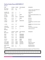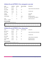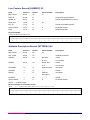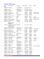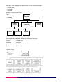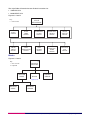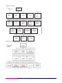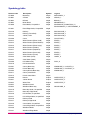
1
Meridian 2
User guide
Contents
Section
Preface
Chapter 1
Chapter 2
Chapter 3
Annexe A
Page no
..................................................................................................................................................3
Contact details ..........................................................................................................................3
Use of the product.....................................................................................................................3
Purpose and disclaimer ............................................................................................................3
Copyright...................................................................................................................................3
Data copyright and other intellectual property rights ................................................................4
Trademarks ...............................................................................................................................4
Back-up provision of the product ..............................................................................................4
Using this guide.........................................................................................................................4
Introduction .............................................................................................................................5
Meridian 2 features ...................................................................................................................5
Applications of Meridian 2.........................................................................................................5
What you need to use Meridian 2 .............................................................................................6
Computer hardware .............................................................................................................6
Computer software...............................................................................................................6
Supply .......................................................................................................................................6
Meridian 2 supply options ....................................................................................................6
Meridian 2 supply formats....................................................................................................7
Meridian 2 supply media......................................................................................................7
High-level product overview ..................................................................................................8
Source of Meridian 2.................................................................................................................8
Currency....................................................................................................................................8
Accuracy and resolution............................................................................................................8
Completeness ...........................................................................................................................8
Meridian general specifications.................................................................................................9
The National Grid ..................................................................................................................10
Product and service performance report form ..................................................................11
v5.2 – 02/2007
Meridian 2 user guide contents v5.2 – 02/2007 © Crown copyright Page 2 of 93
User guide
Preface
This user guide (hereafter referred to as the guide) is designed to provide an overview of Meridian 2
(hereafter referred to as the product). If you find an error or omission in this guide, or otherwise wish to make
a comment or suggestion as to how we can improve the guide, please contact us at the address shown
below under contact details or complete the product and service performance report form at annexe A and
return it to us.
Contact details
Our Customer Service Centre will be pleased to deal with your enquiries:
Customer Service Centre
Ordnance Survey
Romsey Road
SOUTHAMPTON
SO16 4GU
Business enquiries: +44 (0) 23 8030 5030
General enquiries (calls charged at local rate): 08456 05 05 05
Dedicated Welsh Language HelpLine: 08456 05 05 04
Textphone (deaf and hard of hearing users only please): +44 (0) 23 8079 2906
Email: [email protected]
or visit the Ordnance Survey® website at: www.ordnancesurvey.co.uk
Use of the product
The terms and conditions upon which the product, including this guide, is made available to you and your
organisation are contained in the customer contract made between you and Ordnance Survey. If there is an
inconsistency between the terms of your customer contract and this guide, then the terms of your customer
contract prevail. If you or your organisation has not signed a valid current customer contract then you are not
entitled to use the product.
Purpose and disclaimer
This guide is provided for guidance only and does not constitute any warranty, representation, undertaking,
commitment or obligation (express or implied) about the product or its suitability for any particular or intended
purpose. Any warranties, representations, undertakings, commitments and obligations given by
Ordnance Survey about the product and/or its suitability for any particular or intended purpose are set out in
your customer contract. It is your responsibility to ensure that this product is suitable for your intended
purpose.
Ordnance Survey does not accept any liability (whether for breach of contract, negligence or otherwise) for
any loss or liability you or any third party may suffer in relying on this guide and any guidance, suggestion,
advice or explanation provided in it. Any liability that Ordnance Survey has to you in relation to the product,
its supply, use, accuracy, data supplied, functionality or any other liability arising out of or in connection with
the product is limited as set out in your customer contract.
We may change the information in this guide at any time without notice.
We do not accept responsibility for the content of any third party websites referenced or accessed in or
through this guide, any contractual documentation, and/or the Ordnance Survey website.
Copyright
This guide (including for the avoidance of doubt any mapping images reproduced herein), is © Crown copyright
2007. All rights reserved.
Meridian 2 user guide preface v5.2 – 02/2007 © Crown copyright Page 3 of 93
Any part of this guide may be copied for use internally in your organisation or business so that you can use
the product for the purpose for which it is licensed to your organisation or business (but not otherwise).
No part of this guide may be reproduced or transmitted in any form or by any means (including electronically)
for commercial exploitation without the prior written consent of Ordnance Survey.
No part of this guide may be copied or incorporated in products, services or publications that you generate
for onward sale, or as free promotional or support materials, without the prior written consent of
Ordnance Survey.
Data copyright and other intellectual property rights
The Crown (or, where applicable, Ordnance Survey’s suppliers) owns the intellectual property rights in
Ordnance Survey digital map data.
Full details of the terms and conditions under which Ordnance Survey digital map data may be processed
and/or manipulated or copied by a customer – whether or not for use on PCs or workstations or for making
hard copies – are available from the Customer Service Centre, please see Contact details. You should check
the terms and conditions with us before using the data. It is also the responsibility of the holder of the digital
map data to ensure that any plotted or printed output contains the required copyright and database
acknowledgements in a conspicuous position.
All aspects of Meridian 2 discussed in this user guide relate to Meridian 2 in both BS7567 (NTF v2.0) and
DXF™ (AutoCAD® Release 12). If the two format versions differ in their treatment of a particular aspect, the
specific differences will be stated.
Trademarks
Ordnance Survey, the OS Symbol, Land-Form PANORAMA, Land-Line, Landranger, and Strategi are
registered trademarks and Boundary-Line and Meridian are trademarks of Ordnance Survey, the national
mapping agency of Great Britain.
ArcInfo, ArcView and ESRI are registered trademarks of Environmental Systems Research Institute, Inc.
AutoCAD and Autodesk are registered trademarks and DXF is a trademark of Autodesk Inc.
Helvetica and Univers are registered trademarks and Times is a trademark of Heidelberger Druckmaschinen AG.
MapInfo is a registered trademark of MapInfo Corporation.
Back-up provision of the product
You are advised to copy the supplied data to a back-up medium.
Using this guide
The documentation is supplied in portable document format (PDF) only. Free Adobe® Acrobat Reader®
software, which displays the guide, incorporates search and zoom facilities and allows you to navigate
within. Hyperlinks are used to navigate between associated parts of the guide and to relevant Internet
resources by clicking on the blue hyperlinks and the table of contents.
The guide provides an introduction to the structure and content of the product and assumes a general
knowledge of geographic information. It also gives guidelines and advice on how a customer might derive
the maximum benefit from the product.
If you are unfamiliar with any words or terms used and require clarification please refer to the glossary at the
end of the document.
Meridian 2 user guide preface v5.2 – 02/2007 © Crown copyright Page 4 of 93
Chapter 1
Introduction
Concepts of Meridian 2 are explained fully in chapter 2.
Meridian 2 is supplied as data only and does not include software for data viewing or manipulation.
Meridian 2 is supplied in NTF or DXF will require specific software such as GIS or CAD.
NTF is a nationally agreed standard for the transfer of geographical data. NTF allows users of GIS to
customise their own definition of the data for display and/or plotting for their specific applications.
Meridian 2 is also available as data in Mid/Mif and Shapefile formats, which require specific software such as
MapInfo® Professional or ArcView®.
The database has been derived from Ordnance Survey’s existing large and small-scale digital databases.
Meridian 2 features
• Meridian 2 has feature codes that allow everything in the database to be allocated to a specific category;
users can group like features for search, display and output routines.
• Meridian 2 is defined as a limited link-and-node structure within each layer. It contains points, lines and
nodes. Nodes have pointers to lines that join at the node and, similarly, there are lines that enclose an
area containing a point. Some points are not contained within areas enclosed by lines.
• Department for Transport (DfT) road classification numbers are stored in attribute records and are applied
to features such as roads. Names applying to administrative areas and developed land use areas are
also included in the attribute record of the appropriate point feature.
• Annual updating of many of the source databases ensures that high standards of currency and integrity
are maintained. The road network in Meridian 2 is a derived and simplified network that has been
produced from Ordnance Survey Roads Database.
Applications of Meridian 2
There are many potential applications for Meridian 2. These include:
• Environmental analysis.
• Flood areas analysis.
• Land management.
• Commercial and/or business site development.
• Retail and/or wholesale trades.
• Distribution networks:
• store and/or warehouse locations; and
• strategic business expansion and/or development.
• Marketing and media planning:
• sales force locations and/or territories;
• sales prospecting;
• market analysis of customers, competitors or outlet densities;
• market analysis of direct mail responses;
• poster distribution;
• TV and/or radio advertising regions; and
• product and/or brand promotion campaigns.
• Financial/Insurance:
• customer bases; and
• high/low-risk areas.
Meridian 2 user guide chapter 1 v5.2 – 02/2007 © Crown copyright Page 5 of 93
• Health:
• community health; and
• health black spots.
• Leisure activities:
• large site planning, for example, golf courses;
• tourism; and
• theme park locations.
What you need to use Meridian 2
Computer hardware
This product may be used on a wide range of hardware platforms (provided sufficient memory and storage
facilities are available), varying from desktop PCs using GIS or CAD to mainframe computers with
specialised translators and applications.
Computer software
Meridian 2 is supplied as inert data and does not include software for data manipulation. To exploit fully the
potential of Meridian 2 it is necessary to use appropriate application software such as GIS or CAD.
BS 7567
NTF
DXF
NTF allows users of GIS to customise their own definition of the data and/or
plotting for their specific applications. The parameters defining colours, line
styles, text styles, symbols and so on should be built into user software.
Meridian 2 may be customised by viewing or plotting features in different colours,
line styles and scales to suit different applications. Certain classes of features
may be omitted from customised plans on the basis of selection by feature code.
DXF is designed for use with Autodesk® Ltd CAD software, particularly AutoCAD.
The parameters defining colours, line styles, text styles, symbols and so on are
embedded within the DXF file, as is customary with this CAD format.
Please check with your supplier if you are unsure of your CAD system’s compatibility with Meridian 2.
Meridian is also available as data in Mid/Mif and shapefile formats which require specific software such as
MapInfo Professional or ArcView.
Supply
Meridian 2 supply options
The options for data supply are as follows:
• Combined theme: all layers.
• Communication theme: roads and railways, boundaries and coastline.
• Topographic theme: boundaries and coastline, developed land use areas (DLUAs), cartographic names,
hydrology, woodlands and gridded height.
NOTE: Gridded height is supplied with the Meridian 2 supply options but on a separate CD.
Meridian 2 user guide chapter 1 v5.2 – 02/2007 © Crown copyright Page 6 of 93
All themes are available as:
• Complete national cover of Great Britain (2 856 tiles).
• England.
• Scotland.
• Wales.
(These areas correspond with Nomenclature des Unites Territoriales Statistique (NUTS) Level 1 Areas.)
• 10 km by 10 km tiles.
Meridian 2 supply formats
Meridian 2 is available in:
• NTF BS 7567 v2.0 Level 3; or
• DXF (conforming to AutoCAD release 12 with extended entity data).
• Mid/Mif (MapInfo).
• Shapefile (ESRI®).
Meridian 2 supply media
Data is supplied on CD-ROM for all of the above formats.
Data supply structures:
MID/MIF Root directory
|_Doc
| |_Disccare.txt
| |_Meridian2006*_readme.txt
|_Data
|_Data files
NTF and DXF Root directory
|_Doc
| |_Disccare.txt
| |_Meridian2006*_readme.txt
|_Data
|_100k Folder structure (for example, TQ)
|_Data files
SHAPE Root directory
|_Doc
| |_Disccare.txt
| |_Meridian2006*_readme.txt
|_Data
|_cartotext
|_info
|_Data files
*The year changes to reflect the year of release.
Meridian 2 user guide chapter 1 v5.2 – 02/2007 © Crown copyright Page 7 of 93
Chapter 2
High-level product overview
Source of Meridian 2
Meridian 2 data are derived from large-scale and small-scale digital databases. The data capture source and
scales are:
Feature
Original data source
Source scales
Road network
Roads centrelines
Ordnance Survey Roads
Database
1:1250, 1:2500 and 1:10 000
Railways
Large-scale database
1:1250, 1:2500 and 1:10 000
™
County, district and London
borough for England
Boundary-Line
1:10 000
Unitary authority areas for Wales
Boundary-Line
1:10 000
Unitary authority areas for
Scotland
Boundary-Line
1:10 000
Coastline
Landranger®
1:50 000
Developed land use areas and
place names
Strategi®
1:250 000
Hydrology
Strategi
1:250 000
Woodlands
Strategi
1:250 000
Gridded height
Land-Form PANORAMA®
1:50 000
Currency
Meridian 2 data is derived from the latest available versions of Ordnance Survey’s databases. The
Meridian 2 dataset will be refreshed annually.
The large- and small-scale databases are controlled by the revision criteria for topography that are defined
by Ordnance Survey for the various geographical areas.
Accuracy and resolution
The resolution of the data supplied is 1 metre. Meridian 2 data retains the same accuracy as the source data
during its capture. However, it is not possible to calculate meaningful accuracy criteria for these data due to
different source databases.
The Ordnance Survey Road Database has a 20 m filter applied to the centreline, which is supplied to a 1 m
resolution. The 20 m filter does not affect the positional accuracy of node points.
During the updating of the road data there is a comparison buffer created – around the existing road data –
to detect change. This buffer is set to 3 m either side of a feature, 5 m at each end, and 10% of the length.
Administrative areas and roads data have a 20 m lateral filter applied to the boundary and centrelines. The
20 m filter does not affect the positional accuracy of node points.
Features derived from the small-scale databases have been subjected to generalisation – information is
cartographically represented in areas where accurate positional representation would cause confusing clutter
on the viewed image. To maintain positional relationships such data has been further adjusted to fit the
hierarchy where necessary.
Completeness
During production, many checks are undertaken to ensure that data supplied to customers are both accurate
and complete. During digital manipulation in creating the upgraded data, all sources of that data are checked
against specification documentation to identify whether any features have been omitted or misaligned.
Meridian 2 user guide chapter 2 v5.2 – 02/2007 © Crown copyright Page 8 of 93
These quality control checks take the form of:
• visual checks by operators;
• independent quality assurance checks; and
• computer validation with the specification.
Meridian general specifications
The following gives details of the product specification identity and its relationship to Ordnance Survey data
capture specifications. Version details of these specifications are also stated.
Product
Product specification
Meridian 2
Meridian_02.00
Transfer format specifications
Name
NTF (BS 7567)
DXF (Release 12)
Level
3
Version
2
1
Issue date
15 May 1992
1 January 1997
Shape
MID/MIF
Meridian 2 user guide chapter 2 v5.2 – 02/2007 © Crown copyright Page 9 of 93
Chapter 3
The National Grid
Meridian 2 tiles are identified by quoting the National Grid reference of the south-west corner of the area they
cover. The Ordnance Survey National Grid divides Great Britain into squares 100 km by 100 km. Each of
these squares has a unique two-letter reference, for example, TG in the diagram below.
Each Meridian 2, 10 km by 10 km tile is
described by adding a two-digit reference to
the 100 km by 100 km square reference,
with the easting first followed by the
northing, for example, TG23.
For additional information on how to use the
National Grid, visit Ordnance Survey’s
website at:
http://www.ordnancesurvey.co.uk/
© Crown copyright
100 km by 100 km square TG
3
2
10 km by 10 km square TG 23
Meridian 2 user guide chapter 3 v5.2 – 02/2007 © Crown copyright Page 10 of 93
Annexe A
Product and service performance report form
Ordnance Survey welcomes feedback from its customers about Meridian 2.
If you would like to share your thoughts with us, please print a copy of this form and when completed post or
fax it to the address below.
Your name: ..........................................................................................................................................................
Organisation: .......................................................................................................................................................
Address: ...............................................................................................................................................................
..............................................................................................................................................................................
..............................................................................................................................................................................
Postcode: .............................................................................................................................................................
Phone: .................................................................................................................................................................
Fax: ......................................................................................................................................................................
Email: ...................................................................................................................................................................
Quotation or order reference: ..............................................................................................................................
Please record your comments or feedback in the space below. We will acknowledge receipt of your form
within three (3) working days and provide you with a full reply or a status report within 21 working days.
If you are posting this form, please send it to:
Meridian 2 Product Manager, Ordnance Survey, Romsey Road, SOUTHAMPTON, SO16 4GU.
If you wish to return it by fax, please dial 023 8079 2615.
Any personal information that you supply with this report form will be used by Ordnance Survey only in the
improvement of its products and services. It will not be made available to third parties.
Meridian 2 user guide annexe A v5.2 – 02/2007 © Crown copyright Page 11 of 93
Meridian 2
Technical specification
Contents
Section
Introduction
Chapter 1
Chapter 2
Chapter 3
Page no
................................................................................................................................................15
Purpose of this specification and disclaimer...........................................................................15
Copyright.................................................................................................................................15
Trademarks .............................................................................................................................15
Using this specification ...........................................................................................................15
Overview of Meridian 2.........................................................................................................16
Using this technical specification ............................................................................................16
Data overview .........................................................................................................................16
Basic principles ..................................................................................................................16
Meridian 2 vector data structure ........................................................................................16
Meridian explained................................................................................................................18
Features ..................................................................................................................................18
Points and lines.......................................................................................................................18
Feature position ......................................................................................................................20
Feature attribute data..............................................................................................................20
Feature codes ....................................................................................................................20
Names as attributes ...........................................................................................................21
Road number (RN) attribute ..............................................................................................21
Trunk road (TR) attribute ...................................................................................................21
Line length (LL) attribute....................................................................................................21
OSODR attribute................................................................................................................21
Link level at node ...............................................................................................................22
Proper name (PN) attribute................................................................................................22
Roundabout (RT) attribute .................................................................................................22
Junction name (JN) attribute..............................................................................................22
Settlement name (SN) attribute .........................................................................................23
Unique identifiers ...............................................................................................................23
Feature layer descriptions.......................................................................................................24
NTF explained........................................................................................................................27
An overview of Meridian 2 in NTF...........................................................................................27
Jackson structure...............................................................................................................28
Transfer set structure..............................................................................................................29
Record size ........................................................................................................................29
Record terminator {EOR}...................................................................................................29
Supply of data on formatted media....................................................................................29
Version management..............................................................................................................30
General ...................................................................................................................................31
Section body ...........................................................................................................................31
Point and line features .......................................................................................................31
Name detail........................................................................................................................32
Node detail.........................................................................................................................32
Feature information relevant to NTF .......................................................................................33
Point features.....................................................................................................................33
Line features ......................................................................................................................33
Coordinates........................................................................................................................33
Bearings.............................................................................................................................33
Attribute codes ...................................................................................................................33
Unique identifiers ...............................................................................................................34
Record IDs .........................................................................................................................35
Feature layers .........................................................................................................................35
Roads.................................................................................................................................35
Railways.............................................................................................................................35
Administrative areas and coastline ....................................................................................36
Developed land use areas (DLUA) ....................................................................................36
Meridian 2 technical specification contents v5.2 – 02/2007 © Crown copyright Page 12 of 93
Chapter 4
Chapter 5
Chapter 6
Chapter 7
Cartographic names...........................................................................................................36
Hydrology...........................................................................................................................36
Woodlands .........................................................................................................................37
Height.................................................................................................................................37
Record structures for the transfer of Meridian 2 in NTF...................................................38
NTF Record List......................................................................................................................38
Volume Header Record [VOLHDREC] 01 ..............................................................................39
Database Header Record [DBHREC] 02................................................................................40
Feature Classification Record [FEATCLASS] 05....................................................................41
Section Header Record [SECHREC] 07.................................................................................42
Attribute Record [ATTREC] 14 for road links..........................................................................43
Attribute Record [ATTREC] 14 for road nodes .......................................................................44
Attribute Record [ATTREC] 14 for administrative area links (county, district, coastline and
neat line) .................................................................................................................................45
Attribute Record [ATTREC] 14 for administrative area points and/or seeds ...............................46
Attribute Record [ATTREC] 14 for nodes (administrative areas, DLUA, coastline and railway,
hydrology and woodlands) and/or edge nodes (all layers) .....................................................47
Attribute Record [ATTREC] 14 for DLUA links .......................................................................47
Attribute Record [ATTREC] 14 for DLUA points and/or seeds ...............................................47
Attribute Record [ATTREC] 14 for cartographic name text ....................................................48
Attribute Record [ATTREC] 14 for railway links......................................................................48
Attribute Record [ATTREC] 14 for railway station nodes .......................................................49
Attribute Record [ATTREC] 14 for water feature (river, small) ...............................................49
Attribute Record [ATTREC] 14 for water area seeds..............................................................50
Attribute Record [ATTREC] 14 for administrative area points and/or seeds ...............................50
Attribute Record [ATTREC] 14 for gridded height point .........................................................51
Point Feature Record [POINTREC] 15 ...................................................................................51
Node Record [NODEREC] 16.................................................................................................52
Two-dimensional Geometry Record [GEOMETRY1] 21 associated with POINTREC ...........53
Two-dimensional Geometry Record [GEOMETRY1] 21 associated with LINEREC ..............53
Line Feature Record [LINEREC] 23 .......................................................................................54
Attribute Description Record [ATTDESC] 40 ..........................................................................54
Text Record [TEXTREC] 43....................................................................................................55
Text Position Record [TEXTPOS] 44......................................................................................55
Text Representation Record [TEXTREP] 45 ..........................................................................56
Comment Record [COMMENT] 90 .........................................................................................56
Volume Terminator Record [VOLTERM] 99 ...........................................................................57
DXF explained .......................................................................................................................58
An overview of Meridian 2 in DXF...........................................................................................58
DXF ....................................................................................................................................58
Structure of Meridian 2 in DXF................................................................................................58
Line features ...........................................................................................................................58
Area features...........................................................................................................................58
Name features ...................................................................................................................59
Drawing content and format....................................................................................................59
Coordinate system .............................................................................................................59
Height.................................................................................................................................59
Layer names ......................................................................................................................59
Neatline..............................................................................................................................59
Grid ....................................................................................................................................59
Grid values.........................................................................................................................59
Meridian 2 DXF layers ............................................................................................................60
DXF footnotes .........................................................................................................................62
DXF file structure for Meridian 2 .........................................................................................63
General ...................................................................................................................................63
Data structure..........................................................................................................................63
Header ...............................................................................................................................64
Tables ................................................................................................................................66
Blocks ................................................................................................................................71
Entities section...................................................................................................................72
End of File group................................................................................................................76
An overview of Meridian 2 in Mid/Mif ..................................................................................77
Meridian 2 is available in Mid/Mif ............................................................................................77
Meridian 2 technical specification contents v5.2 – 02/2007 © Crown copyright Page 13 of 93
Chapter 8
Annexe A
Annexe B
Structure of Meridian 2 in MapInfo..........................................................................................77
Line features ......................................................................................................................77
Area features .....................................................................................................................77
Names features..................................................................................................................77
Drawing content and format....................................................................................................78
Coordinate system .............................................................................................................78
Height.................................................................................................................................78
Layer names ......................................................................................................................78
Neatline..............................................................................................................................78
Grid ....................................................................................................................................78
Grid values.........................................................................................................................78
Important information .........................................................................................................78
An overview of Meridian 2 in ESRI shapefile .....................................................................79
Important information ..............................................................................................................79
Symbology table .....................................................................................................................80
Glossary.................................................................................................................................82
Meridian 2: (MapInfo) Mid/Mif layers ...................................................................................90
Important information ..............................................................................................................90
Roads – post 1 January 2000–current; FC 3000 full specification of Roads Database, tiles as
10 km by 10 km.......................................................................................................................91
Administrative areas and Coastline ........................................................................................91
Developed land use area (DLUA) ...........................................................................................91
Railways..................................................................................................................................92
Cartographic names................................................................................................................92
Hydrology ................................................................................................................................92
Woodlands ..............................................................................................................................93
Height......................................................................................................................................93
Roads – prior to 1 January 2000; FC 6000 stripped Roads Database, tiles as 20 km by
20 km ......................................................................................................................................93
v5.2 – 02/2007
Meridian 2 technical specification contents v5.2 – 02/2007 © Crown copyright Page 14 of 93
Introduction
Purpose of this specification and disclaimer
This is the technical specification (hereafter referred to as the specification) referred to in the Framework
Direct Licence, Specific Use Framework Partner Licence or your other customer contract.
We may change the information in this specification at any time, giving you the notice period specified in the
customer contract made between you and Ordnance Survey.
We do not accept responsibility for the content of any third party websites referenced or accessed in or
through this specification, any other contractual documentation, and/or the Ordnance Survey website.
Copyright
This specification, (including for the avoidance of doubt any mapping images reproduced herein), is
© Crown copyright 2007. All rights reserved.
Any part of this specification may be copied for use internally in your organisation or business so that you can
use Meridian 2 for the purpose for which it is licensed to your organisation or business (but not otherwise).
No part of this specification may be reproduced or transmitted in any form or by any means (including
electronically) for commercial exploitation without the prior written consent of Ordnance Survey.
No part of this specification may be copied or incorporated in products, services or publications that you
generate for onward sale, or as free promotional or support materials, without the prior written consent of
Ordnance Survey.
Trademarks
Ordnance Survey, the OS Symbol, Land-Form PANORAMA, Land-Line, Landranger, and Strategi are
registered trademarks and Boundary-Line and Meridian are trademarks of Ordnance Survey, the national
mapping agency of Great Britain.
ArcInfo, ArcView and ESRI are registered trademarks of Environmental Systems Research Institute, Inc.
AutoCAD and Autodesk are registered trademarks and DXF is a trademark of Autodesk Inc.
Helvetica and Univers are registered trademarks and Times is a trademark of Heidelberger Druckmaschinen AG.
MapInfo is a registered trademark of MapInfo Corporation.
Using this specification
The documentation is supplied in portable document format (PDF) only. Free Adobe® Acrobat Reader®
software, which displays the specification, incorporates search and zoom facilities and allows you to navigate
within. Hyperlinks are used to navigate between associated parts of the specification and to relevant Internet
resources by clicking on the blue hyperlinks and the table of contents.
Ordnance Survey is committed to providing customers with consistently high quality geographic information. As
such Ordnance Survey regularly applies several data quality measures to the product and the associated
documentation. These quality measurements are based on the principles identified in ISO 19113, Geographic
Information-Quality principles (2002).
NOTE: According to North America Standards Institute, although ISO 19113:2002 is applicable to digital
geographic data, its principles can be extended to many other forms of geographic data such as maps,
charts and textual documents.
ISO 19113:2002 does not attempt to define a minimum acceptable level of quality for geographic data.
If you are unfamiliar with any words or terms used and require clarification please refer to the glossary at the
end of the document.
Meridian 2 technical specification introduction v5.2 – 02/2007 © Crown copyright Page 15 of 93
Chapter 1
Overview of Meridian 2
Using this technical specification
Please refer to the glossary if you are unfamiliar with any of the words or terms used. The glossary can be
found at annexe A (attached after the technical specification).
All aspects of Meridian 2 discussed in this technical specification relate to Meridian 2 in both BS 7567
(NTF v2.0) and DXF (AutoCAD Release 12) formats. If the two format versions differ in their treatment of a
particular aspect, the specific differences will be stated.
Data overview
Basic principles
Links represent roads, railways, administrative areas, coastline, DLUA, inland water and woodland area
lines.
Nodes represent all intersections of links within each layer, changes in attributes in links and link ends.
Each feature has associated geometry; this may be a single coordinate pair for a single point feature for a
railway station, or two or more coordinate pairs for a linear feature.
Each feature is classified by means of a feature code.
Roads, railways, railway stations, administrative area seed points, DLUA seed points, inland water and
woodland area seed points have unique identifiers.
Meridian 2 vector data structure
Meridian 2 data within each layer is supplied as vector data, in a link and node structure. Geographical
features are represented as data entities, either as points or lines. Points are fixed positionally by one
coordinate pair, for example, a railway station. Lines are fixed positionally by a series of connected
coordinate points to represent linear map features such as roads, railways and so on. Points and lines within
the data model determine the geometric (positional) characteristics of the data.
Points and lines within the data model also have associated attributes. These give the point and line entities
meaning; that is, they represent the descriptive characteristic of an entity such as a feature code, a name or
numerical value. Lines are also added as closing links (neat lines) along tile edges; these are required to
complete the enclosure of an area. The closing link has a different feature code to the other links enclosing
the area.
Throughout Meridian 2 no line feature crosses from one tile to the next, but a point feature created at the tile
edge has the same coordinate value as its partner on the adjacent tile.
DXF
All features having the same feature code are recorded on the same layer. DXF
has a limited link and node structure; within this structure a feature may be a
name, point, or line. Each feature is free-standing; that is, its topological
relationship to any other feature is not expressed in the data.
Other important data structure concepts include networks and polygons.
Networks are interconnecting features structurally related by means of an explicit point described as a node.
Between the nodes are series of non-intersecting line segments described as links; hence link and node –
see figure 2.1. This is of special interest in GIS where there may be a need to analyse the network in order to
follow routes or to close polygons.
Proprietary GIS software can be used to build and maintain networks for linear features such as roads,
railways and so on, and provides the functionality to store, manage and manipulate this data.
The properties of Meridian 2 make it a suitable basis for users wishing to develop applications using
Meridian 2 together with their own data. As Meridian 2 is based on the National Grid, there is a simple way of
overlaying users’ own data provided the position is given within the National Grid.
The National Grid, as it applies to Meridian 2, is explained in chapter 3 in the user guide section of this
document.
Meridian 2 technical specification chapter 1 v5.2 – 02/2007 © Crown copyright Page 16 of 93
Figure 2.1: Link and node
Points A and B are nodes, as they intersect with other features. The line A–B is the link, and, in this example,
is made up of six individual line segments.
Polygons are continuous areas defined by sets of bounding closed lines. These are implicit within the data,
but can be explicitly created with appropriate software. Stored within recognisable polygons are seed
points, which hold information about that polygon, for example, a county name.
Figure 2.2: Polygon
Point A is the polygon seed point for the area: attached to this point are attributes such as the feature code,
which defines the polygon and its definitive name. These attributes may be transferred to the polygon itself.
The polygon in this example comprises nine individual line segments.
There are also free-standing points, which are not associated with a defining polygon, for example,
Liverpool Lime Street Station.
Meridian 2 technical specification chapter 1 v5.2 – 02/2007 © Crown copyright Page 17 of 93
Chapter 2
Meridian explained
Features
Meridian 2 has two feature classes:
• Point features.
• Line features.
Point features, such as administrative area seed points, and line features, such as roads, railways, and
developed land use areas, are arranged into recognisable categories. A full listing of individual features is
given in chapter 3 of the technical specification.
Each feature has two components:
• Feature position.
• Feature attributes data.
Also explained in this chapter:
• Feature layer descriptions.
DXF
Each feature recorded in Meridian 2 should be considered as a DXF entity. Line
features are recorded as DXF line(s) or polyline(s).
Point features will be recorded in the data as INSERT BLOCKS. Certain standard
symbols are defined in the BLOCKS section of the data file. A list of these standard
symbols is shown in chapter 5. Attributes are stored as extended entity data.
Points and lines
Real-world geographic features are represented in the digital map data as structures of lines and points.
Each point or line has a geometric and attribute component.
The geometric component defines the positional characteristic of the feature, and implicit relationships exist
between points and lines based on relative position. The attribute component defines the descriptive
characteristics of the feature.
Points may exist independently of lines.
A diagrammatic example of a geometric structure is shown in figure 2.1a.
Figure 2.1a: A geometric structure of points and
lines.
Solid black, grey and broken grey lines and
associated points are on different layers.
Tile
Edge
Points
Lines
Points and lines from the geometric structure become features when an attribute, the feature code, has been
added, for example, DLUA seed points are created from points, or DLUA boundaries from lines.
Meridian 2 technical specification chapter 2 v5.2 – 02/2007 © Crown copyright Page 18 of 93
Figure 2.1b: The same geometric structure as
features.
G
A406
Solid black, greys, and broken grey are on different
layers.
C
E
D
A406
In figure 2.1b:
Point A is a seed point with a feature code that
identifies it as a DLUA; the seed point also carries its
name attribute – Bryncethin.
Tile
Edge
Bridgend UA
A406
Point B is a coordinate junction between intersecting
features – in this case, where a minor road intersects
with the A406. This is an example of a node.
B
A406
A
F
Bryncethin
Point C is a position where the A406 in one layer
crosses the DLUA boundary in another layer. There
is no node at this point.
A406
Some points and lines are common to more than one
feature, as in figure 2.1b. Features between D–E and
G–B–F are overlapping features and are stored
separately within each layer of data.
Nodes
Links
Seed points
Separate storage of overlapping features
Figure 2.1c: Roads
Tile id ST68
Figure 2.1d: DLUA
Tile id ST88
LINE_ID 41
E
D
LINE_ID 71
LINE_ID 62
LINE_ID 130
Tile
Edge
LINE_ID 22
A
OSODR: OMJ945LPCABAX
Bryncethin
Tile id ST86
Nodes
Seed point
Links
In figures 2.1c and 2.1d line D–E is common to the minor road and the DLUA boundary and the geometry of
each feature is stored separately.
Meridian 2 technical specification chapter 2 v5.2 – 02/2007 © Crown copyright Page 19 of 93
Figure 2.1e: Administrative areas and coastline
G
Tile
Edge
Bridgend UA
B
F
Nodes
Seed point
Links
In figures 2.1c and 2.1e line G–B–F is common to the A406, the minor road and administrative area
boundary, and the geometry of each feature is stored separately.
Feature position
The geometry of map features is defined in terms of coordinates. All coordinates used in Meridian 2 are
based on the National Grid coordinate referencing system and are quoted to a resolution of 1 m.
The National Grid, as it applies to Meridian 2, is explained more fully in chapter 3 of the user guide.
Feature attribute data
An attribute is the descriptive characteristic of a feature, that is, a non-spatial element.
The geometry of the points and lines within the data would be meaningless to the user unless they are
assigned some distinguishing property. In Ordnance Survey map data terms, an attribute can be a feature
code (in NTF these are numeric codes), for example, 3000, or a distinctive name or number, for example,
Birmingham or M40.
Attribute codes relevant to NTF are listed and described within chapter 3 of the technical specification but an
overview is given below.
Feature codes
Each feature is classified by means of a feature code (FC). A feature code is allocated when each feature is
initially interpreted and captured from the map base. In this way, an A road is distinguished from a B road
and other kinds of line feature by the feature code allocated to it.
BS 7567
NTF
Each feature is classified as belonging to a specific feature code. These feature
codes are listed in chapter 3.
Meridian 2 technical specification chapter 2 v5.2 – 02/2007 © Crown copyright Page 20 of 93
DXF
Each feature is classified as belonging to a specific feature layer. These layers
range in value from G8050570 to G8056801; see the AutoCAD publication Layer
Naming Convention for CAD in the Construction Industry, version 2, based upon
guidelines in BS 1192: Part 5 – Guide for structuring of computer graphic
information. These feature layers are listed in chapter 5. Attributes are stored as
extended entity data.
An additional text feature code for layout of footnotes is included. This feature
code is listed in chapter 5.
These differences in the data are inferred during translation from Ordnance Survey’s internal data format to
the required customer transfer format.
Names as attributes
The criteria for names attribute attachment are:
• Admin name (NM) is an attribute of a seed point in its administrative area, for example, Hampshire
County.
• Proper name (PN) is an attribute of a seed point in a DLUA, for example, Bexhill, or a node point for a
railway station, for example, Great Ayton Station.
• Text (TX) is a text string transferred in an attribute record to be displayed as stand-alone cartographic
text, for example, Southampton – a place name.
• Hydrology (WA) is an attribute of a seed point in a water area.
• Woodlands (FA) are an attribute of a seed point in a woodland area.
Road number (RN) attribute
This attribute defines the DfT road classification number – for example, M40 – that relates to a link. If a road
is not classified, then this attribute will not be present.
Trunk road (TR) attribute
This attribute defines whether the link forms part of a trunk road. If it is, then the link will have a trunk road
attribute with a value of Y; if it is not a trunk road, then there will be no value in this field.
Line length (LL) attribute
This attribute defines the length of the link in metres and will be present for all link records. It is calculated
from the planimetric coordinates making up the link and does not take into account the effect of slope. The
link length in all products refers to the length as recorded in the Roads database.
OSODR attribute
This attribute defines the Ordnance Survey Roads Database Reference (OSODR). This will uniquely identify
any link or node within the national Roads dataset. The OSODR will be used as the unique identifier for each
link and node, rather than the NTF identifiers. The NTF identifiers will be unique within each tile that is
supplied but will not be maintained between supplies.
A road object is part of a road between nodes (junctions) uninterrupted by tile or map edges.
An OSODR refers not just to a single link but may refer to many links that make up a road object – which
may be chained together across tile edges. Thus, on adjoining tiles there may be two or more links with the
same OSODRs. This attribute applies to links and nodes. It will be present for all features.
An OSODR has been assigned to all existing features (links and nodes) in the Roads database. Any features
that are new to Roads after the initial allocation will be assigned an OSODR when they are loaded to the
database.
Meridian 2 technical specification chapter 2 v5.2 – 02/2007 © Crown copyright Page 21 of 93
The OSODR for a feature will never be modified – only created and deleted. However, there may be many
changes to a feature with a specific OSODR during the lifetime of that OSODR allocation. There are two
reasons for changes. These are:
1 The coordinates of the feature may move within a specified tolerance – currently 3 m either side of a link,
10% of its length, and 5 m movement of any node.
2 The attributes associated with a feature may change. Any changes to these attributes will not affect the
OSODR allocated to that feature.
The following attributes may change for link features:
The following attributes may change for node features:
• date of survey of conversion;
• direction of links at node;
• feature code;
• feature code;
• length of link;
• junction name;
• road name;
• number of links at node;
• road number; and
• level of link at node; and
• trunk road indicator.
• settlement name.
If a feature moves by more than the specified tolerance, then the OSODR for the feature will be deleted and
a new OSODR allocated to that feature. If a feature is deleted from the Roads database, then the OSODR
allocated to that feature will cease to exist and will not be reallocated.
Link level at node
The level field in Node Record 16 indicates – for roads – the relative height relationship between intersecting
links at a node. It does not relate to ground surface level. If a road over a bridge can be accessed then a
level value of 0 is used; a value of 1 used when there is no access from one road to the other at an
intersection. See figure 2.2.
Figure 2.2: Grade separation
In this instance the single node will show a
level 0 for all links in Node Record 16 as it is
possible to access any carriageway from any
approach road.
A bridge over a road that cannot be
accessed will show a level value of 1.
Proper name (PN) attribute
This attribute defines the road name associated with any link in the Roads database. If a link does not have
a proper name then the attribute will not be present. Where the road is otherwise not named and part of a
named estate, the estate name will be allocated to the road.
Roundabout (RT) attribute
This attribute defines whether a node is a generalised representation of a roundabout in the Meridian 2 road
data. If it is, then the node will have a roundabout attribute with a value of Y.
Junction name (JN) attribute
This attribute indicates the junction number of motorway junctions and the other classified roads at that
junction. The junction name is variable length text, and is in the format M6J10A, where M6 is the DfT road
number, and J10A indicates that this is the junction numbered 10A of the M6. If the junction has no junction
number, then that part of the junction name is not supplied.
Meridian 2 technical specification chapter 2 v5.2 – 02/2007 © Crown copyright Page 22 of 93
There could be any number of roads at a junction; therefore each classified road at that junction may be
repeated in the junction name attribute. An oblique character (/) separates each road number and junction.
The following is an example of a junction name attribute:
M40J1/A40/A413/A4020
This attribute only applies to nodes. If the node does not have a junction name, then this attribute is not
present.
Settlement name (SN) attribute
This attribute defines the name of a location or settlement. This name will be attached to the node that is
closest to the position of the location or settlement.
Unique identifiers
Unique identifiers are used to uniquely identify some features within Meridian 2. These are:
• OSODR attribute defines the Ordnance Survey Roads Database Reference (OSODR). This will uniquely
identify any link or node within the national roads dataset.
• Railway and railway station identifiers. These uniquely identify any railway link or railway station within the
national Meridian 2 database.
• Developed land use area identifier. This uniquely identifies any DLUA seed point within the national
Meridian 2 database.
• Global identifier. This uniquely identifies any administrative area seed point within the 10 km by 10 km tile.
• Forestry identifier. This identifies any forestry area seed point.
• Hydrology identifier. This identifies any hydrology area seed point.
The unique identifiers are unique references and will be maintained, except where there has been significant
change to a feature.
The unique identifier may refer to several links representing a linear object across tiles, for example, a road
or a railway, which may be chained together across tile edges. Thus, on adjoining tiles there may be two or
more links with the same unique identifier. See figure 2.3.
Figure 2.3: Unique identifiers
Tile id ST68
Tile id ST88
LINE_ID 41
LINE_ID 71
LINE_ID 62
LINE_ID 130
LINE_ID 22
OSODR: OMJ945LPCABAX
Tile id ST86
Unique identifiers have been assigned to all existing roads (links and nodes), railway links and railway
stations and to seed points for administrative areas, DLUAs, hydrology (inland water) and woodlands. Any of
these features that are new to Meridian 2 after the initial allocation will be assigned an appropriate unique
identifier when the database is refreshed.
The unique identifier for a feature will never be modified – only created and/or deleted. If a feature is deleted
from the Meridian 2 database, then the unique identifier allocated to that feature will cease to exist.
Meridian 2 technical specification chapter 2 v5.2 – 02/2007 © Crown copyright Page 23 of 93
Feature layer descriptions
The feature codes that appear in Meridian 2 within each layer are detailed in chapter 6 of the technical
specification. The individual layers are described below.
NOTE: Names or numbers appear in all layers as attributes. The roads layer is the first hierarchical layer; the
other layers will be manipulated to fit in the following 1–8 hierarchical order.
1 Roads
Motorways, major and minor roads are represented in the data. Complex junctions are collapsed to single
nodes and multi-carriageways to single links. To avoid congestion, some minor roads and cul-de-sacs less
than 200 m are not represented in the minor road feature description of the data. Private roads and tracks
are not included.
Hierarchical position 1.
2 Railways
All railway stations open to passengers and single-track passenger lines are represented.
A railway intersection consists of links and a node; but where railways cross at different levels, links are not
broken. Links and nodes carry a feature code.
If the station name differs from the name of the built-up area on Ordnance Survey’s large-scale data, for
example, New Street Station in Birmingham, or if the railway station name is not associated to any built-up
area name, for example, Great Ayton Station, then the points will carry a railway station name. Node
attributes will also be shown as cartographic station names.
To maintain positional relationship, features in this layer may be adjusted and fitted to the roads.
Hierarchical position 2.
3 Administrative areas and coastline
Administrative areas include information for unitary authority areas for Scotland, Wales, county, district and
London borough boundaries for England.
Figure 2.4: Hierarchical relationship of boundaries for England
A
Line A is a county and district
or London borough boundary.
Line B is a district or London
borough boundary.
B
Each link for an administrative area carries a feature code and the administrative level associated with the
left and right sides of that link. This also applies to coastline, but only to the landside of the coastline, that is,
no administrative area information is added to the seaward side.
Each administrative area contains a seed point that identifies the enclosed area and carries a feature code
and the associated administrative area name. Separate areas of the same administrative unit carry seed
points with different identifiers.
Offshore islands carry a county and district or unitary authority seed point. There is no logical connection in
the data between them and administrative units other than the same name attribute.
There is no explicit information to identify which links form the bounds of a particular area. The left and right
county and district pointers on links do not contain the name of the administrative area, but refer to the seed
point that has the administrative area name as its attribute.
The coastline follows the mean high water (MHW) up all estuaries to the normal tidal limit (NTL).
Administrative areas are only shown down to MHW.
The administrative areas are adjusted to the coastline.
To maintain positional relationship, features in this layer may be adjusted and fitted to roads and railways.
Hierarchical position 3.
Meridian 2 technical specification chapter 2 v5.2 – 02/2007 © Crown copyright Page 24 of 93
4 Developed land use areas
Developed land use area (DLUAs) features represent the polygons around cities, towns, villages and
industrial, commercial and business parks as contained within the Strategi dataset.
Link features enclose DLUA features. Such areas contain a seed point that identifies the enclosed area and
carry a feature code and the associated DLUA name. There is no explicit information to identify which
link forms the bounds of a particular area.
The whole DLUA has been positioned to the road pattern by best-fit practice.
Hierarchical position 5.
5 Cartographic names
Place names from the small-scale database and railway station attribute names are shown as independent
text features and located near the feature that they describe.
Place names are collapsed from double-banked, treble-banked or composite text to a single text feature with
all the text as one string.
The text font and text height in metres have been used for these cartographic
names and are – as layers – separate from the feature with which they are
associated. These are the text font identifiers:
DXF
• 0001 has been used for railway text (Times™ Roman – non-italic).
• 0002 has been used for settlement text (Helvetica® bold – sans relief).
• 0003 has been used for water text (Times Roman italic – sans) these are
transferred with the text feature.
• 0004 has been used for town text (Univers® medium Roman condensed) and
text height in millimetres.
The Ordnance Survey convention for the digitising of names is as follows: all names are digitised as point
features, given as X and Y National Grid coordinates. The point has been digitised relative to the map
feature it describes, and the actual point represents one of the standard positions shown in figure 2.5.
Figure 2.5: Standard Ordnance Survey text positions
2
5
1
4
0
3
8
7
6
Names are normally placed on the printed map parallel to the horizontal grid.
DXF
BS 7567
NTF
Position 0 is supplied.
The text string may start, end or be centred on this coordinate pair; the
relationship of the text to its coordinate pair is expressed as an original digitised
position. Where the position of text features is recorded, one of these positions is
digitised. Hierarchical position 5.
Meridian 2 technical specification chapter 2 v5.2 – 02/2007 © Crown copyright Page 25 of 93
6 Hydrology
Each water area contains a seed point identifier that carries a feature code and the associated attribute.
Each link for water boundaries carries a feature code.
To maintain positional relationship, features in this layer may be adjusted and fitted to the hierarchy. See the
note at the beginning of feature layer descriptions earlier in this chapter.
Dark links have been used to maintain the connectivity of the network across lakes and reservoirs. Where
links entering and leaving the lake or reservoir carry the same name, the dark link is attributed with this
name.
Hierarchical position 6.
Figure 2.6: Dark link diagram showing connectivity
A river and tributaries flow into a lake. The amalgamation of these is a dark link running through the middle
of the lake and outputting as a river again.
7 Woodlands
Each link for woodland boundaries carries a feature code. Each woodland area contains a seed point
identifier, which carries a feature code and the associated attribute. To maintain positional relationship,
features in this layer may be adjusted and fitted to hierarchy.
Hierarchical position 7.
8 Gridded height
Height information is produced in the form of digital terrain model (DTM)-style data.
Gridded height information is averaged from the 50-m resolution Land-Form PANORAMA dataset to a
resolution of 200 m and rounded down to the nearest 1-m value.
NOTE: Gridded height is supplied with Meridian 2 on a separate CD.
Meridian 2 technical specification chapter 2 v5.2 – 02/2007 © Crown copyright Page 26 of 93
Chapter 3
NTF explained
An overview of Meridian 2 in NTF
This chapter gives a detailed breakdown of the data structure of Meridian 2 in NTF.
Meridian 2 data is supplied in the British Standard national format common to all Ordnance Survey’s digital
map data products – namely NTF – and is transferred in Level 3 as variable length records. An overview of
the data structure of a Meridian 2 data file is on the following page. The convention used for this diagram is
in the industry standard adopted for Jackson Structured Programming (JSP).
The British Standard for NTF stipulates the following for Level 3:
‘This level supports a variety of data models that may include network data, polygons, semantic relationships
and complex features – for example, a school consisting of its buildings, boundaries and playing fields.’
This level is designed for:
• Transferring basic geometry and simple features through the use of geometry and feature records.
• Relating basic geometrical and topological elements to one or more features through the use of chain,
polygon and complex line records.
• Combining features to form complex features through the use of collection and complex polygon records.
• Using text records both to relate text strings to features and cartographic output.
• Referencing and positioning external features, for example, raster data.
The record structure at this level may also be defined to be compatible with data in Levels 1 and 2.
There are certain conventions used in this technical specification, which are:
[]
Square brackets are placed around record names, for example, [VOLHDREC].
{}
A pair of braces denote field names, for example, {REC_DESC} is the Record Descriptor field.
[ ] 90
A two-digit number following square brackets denotes the record descriptor that uniquely identifies
the record name between the brackets.
<S>
This is the space character (ASCII code 32).
<3S>
This denotes three successive space characters.
%
The percentage character (ASCII code 37).
|
This denotes a repeating group (ASCII code 124).
Meridian 2 technical specification chapter 3 v5.2 – 02/2007 © Crown copyright Page 27 of 93
Jackson structure
The following diagrams are examples of Meridian 2 files and no fixed record sequence or relationship is
implied.
Meridian 2 technical specification chapter 3 v5.2 – 02/2007 © Crown copyright Page 28 of 93
The governing body for the industry standard NTF is the British Standards Institution (BSI). Their address is:
British Standards Institution
Phone: +44 (0)20 8996 9000
389 Chiswick High Road
Fax: +44 (0)20 8996 7001
LONDON
Email: [email protected]
W4 4AL
Any queries relating to the Meridian 2 product should be referred to the Sales Information Helpdesk at the
address given in contact details at the beginning of the user guide section.
Transfer set structure
Record size
NTF data is written to the output device in variable length records, with a maximum record length of 80
characters, which includes {CONT_MARK} and {EOR}.
Record terminator {EOR}
The end of record terminator is the percent (%) (ASCII 37) character for both formatted and unformatted
media.
A transfer set normally equates to a single file except where continuation volumes are used when the
transfer set exceeds the capacity of the media. The data the customer receives is in one or more transfer
sets. Each transfer set starts with a Volume Header Record [VOLHDREC] and terminates with a Volume
Terminator Record [VOLTERM].
Supply of data on formatted media
Data requested on CD is not blocked but is written directly to the output device. The transfer set has one
dataset and one section. One or more transfer sets are put onto the medium. A customer’s order that is
larger than the capacity of the medium is put onto two or more of that media. Continuation volumes are only
to be used if a transfer set is larger than the capacity of the medium.
Formatted media (transfer set less than media capacity)
01
Volume header record
02
Database header record
40
Attribute description record
05
Feature classification record
07
Section header record
01
Tile 1 data
99
*
Volume termination record
01
Volume header record
02
Database header record
40
Attribute description record
05
Feature classification record
07
Section header record
99
Volume termination record
01
Tile 2 data
*
And so on.
Tile n data
99
Volume termination record
*
*
‘99end of transfer set 0%’
Meridian 2 technical specification chapter 3 v5.2 – 02/2007 © Crown copyright Page 29 of 93
01
Volume header record
02
Database header record
40
Attribute description record
05
Feature classification record
07
Section header record
99
Volume termination record
Part tile 1 data
01
Volume header record
02
Database header record
40
Attribute description record
05
Feature classification record
07
Section header record
99
Volume termination record
**
01
01
Volume header record
02
Remainder part tile 1 data
*
**
01
‘99 End Of Volume 01 Transfer Set
Continues On Volume 021%’
Tile 2 data
99
*
Volume termination record
*
‘99End Of Transfer Set 0%’
The beginning of each transfer set is structured with the following introductory, or leading, records:
Database Header Record [DBHREC] – this gives details of:
1 The database name.
2 NTF release date.
3 Feature classification table name.
4 Release date that applies to the whole of the transfer set.
Attribute Description Record [ATTDESC] – this lists and gives a description of the attributes that can be
applied to features within the transfer set.
Feature Classification Record [FEATCLASS] – this lists and gives descriptions of all possible feature codes
for the transfer set.
These introductory records are followed by the data requested by the customer that are contained in the section.
The section consists of two parts:
1 Section Header Record [SECHREC]: this gives the National Grid coordinates of the section and on
unformatted media informs the customer that a new section is starting.
2 Section body: this comprises all the features within the section.
Version management
Each version and release of all Meridian 2 products is defined by a unique product version number and
release number – these are reflected in this technical specification. The product version number relates to
the specification of the data being supplied, and the release number relates to the release of the product.
The product version number takes the form xx.yy, where xx is the major product number, and yy is the minor
change number. Thus version 02.00 would indicate that this is the major product version 02, and that the 00
indicates no minor amendment to the product specification.
The release number takes the form xx.yy, where xx is the sequential release within a year, and yy is the year
of the release. Thus release 01.01 would indicate that this is the first data release in 2001.
The product version number and the release number are specified in the Database Header Record
[DBHREC], as supplied in NTF.
Meridian 2 technical specification chapter 3 v5.2 – 02/2007 © Crown copyright Page 30 of 93
General
• The following are the record definitions for the transfer of Meridian 2 data in NTF:
• Volume Header Record [VOLHDREC]
• Database Header Record [DBHREC]
• Feature Classification Record [FEATCLASS]
• Attribute Description Record [ATTDESC]
• Section Header Record [SECHREC]
• Section body – see Point and line features
• name detail
• node detail
• Volume Terminator Record [VOLTERM]
Section body
This comprises all the features within the tile that correspond to the feature types selected by the customer.
Point and line features
Point feature
Each point feature is depicted by the use of the following records:
Description in NTF
POINT RECORD
[POINTREC]
GEOMETRY RECORD
[GEOMETRY1]
ATTRIBUTE RECORD
[ATTREC]
Line feature
Each line feature is depicted by the use of the following records:
Description in NTF
LINE RECORD
GEOMETRY RECORD
[LINEREC]
[GEOMETRY1]
GEOMETRY
CONTINUATION
RECORDS
ATTRIBUTE RECORDS
[ATTREC]
Geometry records
Geometry records contain the coordinate position(s) in metres of the feature. Point features contain one
coordinate pair; line features contain two or more coordinate pairs. Geometry Continuation Records are used
where required. {X_COORDS}, {Y_COORDS} and {QPLAN} are treated as separate fields.
Meridian 2 technical specification chapter 3 v5.2 – 02/2007 © Crown copyright Page 31 of 93
Name detail
Each cartographically positioned name is depicted by the use of the following records:
Description in NTF
TEXT RECORD
[TEXTREC]
TEXT POSITION RECORD
[TEXTPOS]
TEXT REPRESENTATION RECORD
[TEXTREP]
GEOMETRY RECORD
[GEOMETRY1]
ATTRIBUTE RECORD
[ATTREC]
Records
Text details are only given when a name has been cartographically positioned. The Attribute Record
[ATTREC] contains the definitive name and is pointed to by the Text Record [TEXTREC].
The Text Record [TEXTREC] points to the Attribute Record [ATTREC] and also points to the Text Position
Record [TEXTPOS].
The Text Position Record [TEXTPOS] refers back to the Text Record [TEXTREC] and points to the
Geometry Record [GEOMETRY 1] containing the coordinates of the digitised position. The Text Position
Record [TEXTPOS] also points to the Text Representation Record [TEXTREP], which contains the standard
digitising position and orientation of the text.
All other names are held as attributes only.
Node detail
Node feature
Each node feature is depicted by the use of the following records:
Description in NTF
NODE RECORD
[NODEREC]
NODE
CONTINUATION
RECORD
GEOMETRY RECORD
[GEOMETRY1]
POINT RECORD
[POINTREC]
ATTRIBUTE RECORD
[ATTREC]
All links in Meridian 2 terminate in explicit node records; each node is related to a point and its attributes via
a common geometry record. This structure allows an attribute with a node within the constraints of NTF.
Records
Node Record [NODEREC] transfers details of the bearings and number of lines that meet at a point or node.
The Node Record [NODEREC] contains references to each Line Record [LINEREC] that meets at that node
and to the Geometry Record [GEOMETRY 1]. The Geometry Record [GEOMETRY 1] is referenced by the
Point Records [POINTREC] containing the feature attributes of the node.
Where lines do not meet at a previously specified point feature, a special point feature is created.
The Node Record [NODEREC] can contain details of up to five line features that meet at a node. Further
lines meeting at that node are written to the Node Continuation Record.
It is important to note that, although the Node Record contains references to its appropriate point and line
features, the point and line features do not contain references to the node.
Meridian 2 technical specification chapter 3 v5.2 – 02/2007 © Crown copyright Page 32 of 93
Feature information relevant to NTF
Point features
Point features can exist independently and at the junction or ends of lines. The point feature gives a position
and attribute to the corresponding node.
Line features
All line features, with the exception of where railways cross at different levels, are broken when they intersect
one another within a layer.
NOTE: A layer is a subset of digital map data, selected on a basis other than position. For example, one
layer might consist of all features relating to roads and another to railways.
The first and last coordinate pairs in a line correspond exactly with the start or end coordinates of any
adjoining line(s).
A line cannot cross from one tile (10 km by 10 km square) to the next – it is split on the tile edge; see
Unique identifiers.
All linear features are continuous. Cartographic gaps are closed during the digitising process.
Coordinates
Coordinate values and the number of coordinate pairs in a feature are transferred in the [GEOMETRY1] NTF
record.
All coordinates within the data are expressed as strings of five numeric characters. Leading zeros are
present to complete the five characters.
All coordinates are measured from the local origin, which is the south-west corner of the tile.
To convert coordinate data to full National Grid coordinates, add the coordinates of the feature to those of
the south west corner of the tile. The south-west corner coordinates are contained within the {X_ORIG} and
{Y_ORIG} fields of the Section Header Record ([SECHREC] ‘07’).
Bearings
Bearings are transferred in the {ORIENT} field of the Node Record [NODEREC].
Bearings are National Grid bearings, in degrees, measured clockwise from grid north.
The start of line bearing, indicated by a value of 1 in the {DIR} field of the Node Record [NODEREC], is the
bearing of the first segment of the line. The direction is from the start of the line to the next pair of
coordinates or, if there are only two coordinate pairs, from the start to the end of the line.
The end of line bearing, indicated by a 2 in the {DIR} field, is the bearing of the last segment of the line. The
direction is from the end of the feature to the last-minus-one pair of coordinates.
Attribute codes
Attribute codes provide supplementary information on a feature, providing such qualifying information as
feature code, feature name, orientation and so on.
In NTF, the structure of user-defined attributes is described in the Attribute Description Record [ATTDESC].
The actual attribute detail of a record is written in the Attribute Record [ATTREC].
Meridian 2 technical specification chapter 3 v5.2 – 02/2007 © Crown copyright Page 33 of 93
Attributes that are used in the supply of Meridian 2 data are:
• FC Feature code – contains the numeric feature code of the feature.
• OD OSODR – a unique identifier for links and nodes on road features.
• LL
Length of link.
• RN Road number – DfT route number.
• TR Trunk road indicator.
• RT Roundabout indicator.
• JN Junction name – the name of a road junction.
• LC Left county boundary indicator.
• RC Right county boundary indicator.
• LD Left district* boundary indicator.
• RD Right district* boundary indicator.
• PI
Global ID – a unique identifier for administrative areas.
• DA DLUA ID – a unique identifier for a developed land use area.
• PN Proper name – the definitive name for a developed land use area or railway station.
• RI
Rail ID – a unique railway link identifier.
• SN Settlement name text.
• SI
Station ID – a unique railway station identifier.
• NM Admin name – an administrative area name.
• TX Text – independent text.
• FA Forest ID – a unique identifier for forest areas.
• WA Water area – a unique identifier for water area.
• WI Water link – a unique identifier for water links.
• HT Height ID – a unique identifier for gridded height.
* Includes London borough and unitary authority area.
Unique identifiers
Unique identifiers are used to uniquely identify some features within Meridian 2. These are:
• Ordnance Survey Roads Database Reference (OSODR) – this uniquely identifies any road link or road
node within the national Roads database.
• Railway and railway station identifiers – these uniquely identify any railway link or railway station within
the national Meridian 2 database.
• Developed land use area identifier – this uniquely identifies any developed land use area seed point
within the national Meridian 2 database.
• Global identifier – this uniquely identifies any administrative area seed point within the 10 km by 10 km
tile.
• Water identifier – this uniquely identifies the hydrology (inland water) seed.
• Woodland identifier – this uniquely identifies the woodland seed.
The unique identifiers are unique references and are maintained, except where there has been significant
change to a feature.
The unique identifier may refer to several links representing a linear object across tiles, for example, a road
or a railway, which may be chained together across tile edges. Thus, on adjoining tiles there may be two or
more links with the same unique identifier, see figure 3.1 and figure 3.2.
Meridian 2 technical specification chapter 3 v5.2 – 02/2007 © Crown copyright Page 34 of 93
Record IDs
The identifying fields for each NTF record, for example, NODE_ID for [NODEREC], LINE_ID for [LINEREC]
and so on, are unique within each individual section (tile) supplied. They are not maintained between
supplies.
Figure 3.1: Example of a unique identifier – OSODR
Tile id: ST68
Figure 3.2: Example of unique identifier – a railway
and railway station
Tile id: ST88
LINE_ID 41
Tile id: NT68
Tile id: NT88
NODE_ID 23
LINE_ID 71
LINE_ID 41
LINE_ID 62
LINE_ID 153
LINE_ID 130
OSODR: ODJ945LPCABAX
LINE_ID 22
Railway identifier:
3823110682322
Railway station identifier:
332110684101
Tile id: ST86
LINE_ID 43
Tile id: NT86
Feature layers
This section contains a list of all the valid features used with Meridian 2. The list contains a description of
each feature, its feature type, its feature code (FC) and a list of the attributes, other than FC, which can be
associated with that feature. The list is segmented by feature layer.
NOTE: All features carry the attribute FC as the feature code.
Roads
Feature description
Motorway
A road
B road
Minor road
Road node
Road edge node
Type
Line
Line
Line
Line
Point
Point
Code
3000
3001
3002
3004
3500
3501
Attribute(s)
FC, LL, OD, RN, TR, PN
FC, LL, OD, RN, TR, PN
FC, LL, OD, RN, TR, PN
FC, LL, OD, RN, TR, PN
FC, OD, JN, RT, SN
FC, OD, JN, RT, SN
Type
Line
Line
Point
Point
Point
Code
6140
6142
6155
6730
6731
Attribute(s)
FC, RI
FC, RI
FC, SI, PN
FC
FC
Railways
Feature description
Railway
Tunnelled railway
Railway station
Railway node
Railway edge node
Meridian 2 technical specification chapter 3 v5.2 – 02/2007 © Crown copyright Page 35 of 93
Administrative areas and coastline
Feature description
County boundary
District* boundary
County/district* boundary
Neat line
County seed
District* seed
Boundary node
Boundary edge node
Coastline
Coastline node
Coastline edge node
Type
Line
Line
Line
Line
Point
Point
Point
Point
Line
Point
Point
Code
6401
6403
6405
6800
6411
6415
6710
6711
6200
6740
6741
Attribute(s)
FC, LC, RC, LD, RD
FC, LD, RD
FC, LC, RC, LD, RD
FC, LC, RC, LD, RD
FC, PI, NM
FC, PI, NM
FC
FC
FC, LC, RC, LD, RD
FC
FC
NOTE:* Includes London borough and unitary authority areas.
Developed land use areas (DLUA)
Feature description
DLUA boundary
DLUA seed
DLUA node
DLUA edge node
Neat line
Type
Line
Point
Point
Point
Line
Code
6300
6310
6720
6721
6801
Attribute(s)
FC
FC, PN, DA
FC
FC
FC
Type
Point
Point
Code
6500
6551
Attribute(s)
FC, TX
FC, TX
Feature description
Type
Code
Attribute(s)
Water feature river small
Line
6223
FC, WI, PN
Water feature river medium
Line
6224
FC, WI, PN
Water feature river large
Line
6225
FC, WI, PN
Water feature hidden water
Line
6230
FC, WI, PN
Water feature aqueduct
Line
6231
FC, WI, PN
Water feature dark link
Line
6232
FC, WI, PN
Water feature canal
Line
6243
FC, WI, PN
Water feature lake
Line
6255
FC, WI
Area water seed
Point
6292
FC, WA
Water text
Point
6552
FC, TX
Water feature node
Point
6770
FC
Area water node
Point
6771
FC
Area water edge node
Point
6772
FC
Water feature edge node
Point
6773
FC
Area water neat line
Line
6803
FC
Cartographic names
Feature description
Place name
Station name
Hydrology
Meridian 2 technical specification chapter 3 v5.2 – 02/2007 © Crown copyright Page 36 of 93
Woodlands
Feature description
Woodland boundary
Woodland seed
Woodland node
Woodland edge node
Woodland neat line
Type
Line
Point
Point
Point
Line
Code
6664
6663
6750
6751
6802
Attribute(s)
FC
FC, FA,
FC
FC
FC
Code
6762
Attribute(s)
FC, HT
Height
Feature description
Gridded height
Type
Point
Meridian 2 technical specification chapter 3 v5.2 – 02/2007 © Crown copyright Page 37 of 93
Chapter 4
Record structures for the transfer of Meridian 2 in
NTF
NTF Record List
This list comprises the valid record types used in the Meridian 2 NTF transfer set.
Descriptor
Description
Record name
01
Volume Header Record – defines the donor and data type.
[VOLHDREC]
02
Database Header Record – transfers data about the database.
[DBHREC]
05
Feature Classification Record – defines data classifications.
[FEATCLASS]
07
Section Header Record – defines coordinate and structure types,
unit scale, factors and so on.
[SECHREC]
14
Attribute Record – defines the attributes for line and point records.
[ATTREC]
15
Point Record – identifies the definition of node points.
[POINTREC]
16
Node Record – defines the topological relationship between links
and nodes.
[NODEREC]
21
Two-dimensional Geometry Record – defines the two-dimensional
geometry for a link or node.
[GEOMETRY1]
23
Line Record – identifies the definition of a link.
[LINEREC]
40
Attribute Description Record – defines attribute descriptions and
their fields.
[ATTDESC]
43
Text Record – identifies the Text Position Record and Attribute
Record.
[TEXTREC]
44
Text Position Record – identifies the Text Representation Record
and Geometry Record.
[TEXTPOS]
45
Text Representation Record – defines the font, text height and
digitised position.
[TEXTREP]
90
Comment Record – transfers change information or information
about empty tiles.
[COMMENT]
99
Volume Terminator Record – defines the end of the transfer set.
[VOLTERM]
NOTE: Where Meridian 2 height differs from Meridian 2 full dataset, a record example will be shown.
Meridian 2 technical specification chapter 4 v5.2 – 02/2007 © Crown copyright Page 38 of 93
Volume Header Record [VOLHDREC] 01
Field
Position
Format
Value example
Description
REC_DESC
01:02
A2
01
DONOR
03:22
A20
ORDNANCE SURVEY<5S>
RECIPIENT
23:42
A20
<20S>
Not used.
TRANDATE
43:50
DATE
yyyymmdd
Supply date.
SERIAL
51:54
I4
0000
Not used.
VOLNUM
55:56
I2
nn
Volume number 01 to 99.
NTFLEVEL
57:57
I1
3
NTF Level 3.
NTFVER
58:61
R4.2
0200
NTF Version 2.0.
NTFOR
62:62
A1
V
Variable length records.
EOR
63:63
A1
%
Sets [EOR] to % on formatted
media
or <S>
or default % for formatted
media.
DIVIDER
64:64
A1
\
Divider used to terminate
variable length text fields.
CONT_MARK
65:65
I1
0
No further records.
EOR
66:66
A1
%
Record terminator.
Record example:
01ORDNANCE SURVEY
2001121000000130200V \0%
|
1
|
2
|
3
|
4
|
5
|
6
|
7
|
8
12345678901234567890123456789012345678901234567890123456789012345678901234567890
|
|
|
|
|
|
|
|
|
|
|
|
|
|
|
|
Template
Meridian 2 technical specification chapter 4 v5.2 – 02/2007 © Crown copyright Page 39 of 93
Database Header Record [DBHREC] 02
Record 1
Field
Position
Format
Value example
Description
REC_DESC
01:02
A2
02
Record type identifier.
DBNAME
03:22
A20
Meridian_02.01<6S>
Database name.
DDNAME
23:42
A20
DEFAULT_02.00<7S>
Standard data dictionary name.
DDATE
43:50
DATE
19920515
Release date of NTF version being
used.
DDBASE
51:70
A20
<20S>
Not used.
DDBDATE
71:78
DATE
00000000
Not used.
CONT_MARK
79:79
I1
1
Continuation record follows.
EOR
80:80
A1
%
Record terminator.
Field
Position
Format
Value example
Description
REC_DESC
01:02
A2
00
FCNAME
03:22
A20
Meridian_02.00<6S>
Data specification (product version).
FCDATE
23:30
DATE
20000901
Date of data specification.
DQNAME
31:50
A20
<20S>
Not used.
DQDATE
51:58
DATE
00000000
Not used.
DATA_MODEL
59:60
I2
00
CONT_MARK
61:61
I1
0
No further records.
EOR
62:62
A1
%
Record terminator.
Record 2
Record example:
02Meridian02.01
DEFAULT_02.00
19920515
000000001%
00Meridian_02.00
20000901
00000000000%
|
1
|
2
|
3
|
4
|
5
|
6
|
7
|
8
12345678901234567890123456789012345678901234567890123456789012345678901234567890
|
|
|
|
|
|
|
|
|
|
|
|
|
|
|
|
Template
Gridded height record example:
02Meridian2_ht_01.99 DEFAULT_02.00
19920515
000000001%
00Meridian_02.00
20000901
00000000000%
|
1
|
2
|
3
|
4
|
5
|
6
|
7
|
8
12345678901234567890123456789012345678901234567890123456789012345678901234567890
|
|
|
|
|
|
|
|
|
|
|
|
|
|
|
|
Template
Meridian 2 technical specification chapter 4 v5.2 – 02/2007 © Crown copyright Page 40 of 93
Feature Classification Record [FEATCLASS] 05
Field
Position
Format
Value example
Description
REC_DESC
01:02
A2
05
FEAT_CODE
03:06
I4
CODE_COM
07:16
A10
<10S>
Not used.
STCLASS
17:36
A20
<20S>
Not used.
FEATDES
37:*
A*
DIVIDER
*:*
A1
\
Divider.
CONT_MARK
*:*
I1
0
No further records.
EOR
*:*
A1
%
Record terminator.
Contains four-character feature
code.
Feature description.
NOTE: * = variable integer
Record example:
053000
Motorway\0%
|
1
|
2
|
3
|
4
|
5
|
6
|
7
|
8
12345678901234567890123456789012345678901234567890123456789012345678901234567890
|
|
|
|
|
|
|
|
|
|
|
|
|
|
|
|
Template
Meridian 2 technical specification chapter 4 v5.2 – 02/2007 © Crown copyright Page 41 of 93
Section Header Record [SECHREC] 07
Record 1
Field
Position
Format
Value example
Description
REC_DESC
01:02
A2
07
SECT_REF
03:12
A10
COORD_TYP
13:13
I1
2
Rectangular.
STRUCT_TYP
14:14
I1
1
Vector.
XYLEN
15:19
I5
00005
Five-character coordinate fields (to 1 m).
XY_UNIT
20:20
I1
2
Metres.
XY_MULT
21:30
R10.3
0000001000
Default.
ZLEN
31:35
I5
00000
Not used.
Z_UNIT
36:36
I1
0
Not used.
Z_MULT
37:46
R10.3
0000001000
Not used.
X_ORIG
47:56
I10
X coordinates of south-west corner
of unit.
Y_ORIG
57:66
I10
Y coordinates of south-west corner
of unit.
Z_DATUM
67:76
I10
0000000000
Not used.
CONT_MARK
77:77
I1
1
Continuation record follows.
EOR
78:78
A1
%
Record terminator.
Field
Position
Format
Value example
Description
REC_DESC
01:02
A2
00
XMIN
03:12
I10
0000000000
YMIN
13:22
I10
0000000000
XMAX
23:32
I10
0000010000
YMAX
33:42
I10
0000010000
XY_ACC
43:47
R5.2
00000
Not used.
Z_ACC
48:52
R5.2
00000
Not used.
SURV_DATE
53:60
DATE
00000000
Not used.
LAST_AMND
61:68
DATE
yyyymmdd
Date last amended.
COPYRIGHT
69:76
DATE
yyyymmdd
Copyright date.
CONT_MARK
77:77
I1
0
No further records.
EOR
78:78
A1
%
Record terminator.
10 km by 10 km tile reference, for
example, TQ24<6S>.
Record 2
Record example:
07TQ24
21000052000000100000000000000010000000520000000014000000000000001%
00000000000000000000000000010000000001000000000000000000000020011210200112100%
|
1
|
2
|
3
|
4
|
5
|
6
|
7
|
8
12345678901234567890123456789012345678901234567890123456789012345678901234567890
|
|
|
|
|
|
|
|
|
|
|
|
|
|
|
|
Template
NOTE 1: Last amend date will not be used for Mer_2_rds.
Meridian 2 technical specification chapter 4 v5.2 – 02/2007 © Crown copyright Page 42 of 93
Attribute Record [ATTREC] 14 for road links
Field
Position
Format
Value example
REC_DESC
01:02
A2
14
ATT_ID
03:08
I6
VAL_TYPE
09:10
A2
VALUE
11:23
A13
VAL_TYPE
24:25
A2
VALUE
26:29
I4
VAL_TYPE
30:31
A2
VALUE
32:33
I5
VAL_TYPE
*:*
A2
VALUE
*:*
A*
DIVIDER
*:*
A1
\
VAL_TYPE
*:*
A2
RN
VALUE
*:*
A*
DIVIDER
*:*
A1
\
VAL_TYPE
*:*
A2
TR
VALUE
*:*
A1
Y
Trunk road indicator.
CONT_MARK
*:*
I1
0
No further records.
or 1
Continuation record.
%
Record terminator.
EOR
*:*
A1
Description
Unique ID for record.
OD
Unique ID (OSODR) for link.
FC
Feature code.
LL
Length of link.
PN
Road name.
Road number.
NOTE: * = variable integer.
Record example:
14000001ODO338UHK0PLWAXFC3001LL00342PNCOMMERCIAL STREET\NP02POO1J945LPCABAXPO1%
00O1CB3HJ50VFWARNA315(T)\TRY0%
|
1
|
2
|
3
|
4
|
5
|
6
|
7
|
8
12345678901234567890123456789012345678901234567890123456789012345678901234567890
|
|
|
|
|
|
|
|
|
|
|
|
|
|
|
|
Template
NOTE 1: PN, RN and TR records will only be included where a name exists.
Meridian 2 technical specification chapter 4 v5.2 – 02/2007 © Crown copyright Page 43 of 93
Attribute Record [ATTREC] 14 for road nodes
Field
Position
Format
Value example
REC_DESC
01:02
A2
14
ATT_ID
03:08
I6
VAL_TYPE
09:10
A2
VALUE
11:23
A13
VAL_TYPE
24:25
A2
VALUE
26:29
I4
VAL_TYPE
*:*
A2
VALUE
*:*
A*
DIVIDER
*:*
A1
\
VAL_TYPE
*:*
A2
SN
VALUE
*:*
A*
DIVIDER
*:*
A1
\
VALUE TYPE
*:*
A2
RT
VALUE
*:*
A1
Y
Roundabout.
CONT_MARK
*:*
I1
0
No further records.
or 1
Continuation record.
%
Record terminator.
EOR
*:*
A1
Description
Unique ID for record.
OD
Unique ID (OSODR) for node.
FC
Feature code.
JN
Junction name.
Settlement name.
NOTE: * = variable integer.
Record example:
14000023ODO3DF42CK0VTEGFC3500NP03POO1J945LPCABATPOO142WFUP80AA0POO1CV33LKPCBXE1%
00JNM27 J2\SNSOUTHAMPTON\RTY0%
|
1
|
2
|
3
|
4
|
5
|
6
|
7
|
8
12345678901234567890123456789012345678901234567890123456789012345678901234567890
|
|
|
|
|
|
|
|
|
|
|
|
|
|
|
|
Template
NOTE 1: JN, SN and RT records will only be included where a name exists.
Meridian 2 technical specification chapter 4 v5.2 – 02/2007 © Crown copyright Page 44 of 93
Attribute Record [ATTREC] 14 for administrative area links (county,
district, coastline and neat line)
Field
Position
Format
Value example
Description
REC_DESC
01:02
A2
14
ATT_ID
03:08
I6
VAL_TYPE
09:10
A2
VALUE
11:14
I4
AL_TYPE
15:16
A2
VALUE
17:22
I6
AL_TYPE
23:24
A2
VALUE
25:30
I6
VAL_TYPE
31:32
A2
VALUE
33:38
I6
AL_TYPE
39:40
A2
VALUE
41:46
I6
CONT_MARK
47:47
I1
0
No further records.
EOR
48:48
A1
%
Record terminator.
Unique attribute record identifier.
FC
Feature code.
LC
Left county pointer to seed
(optional).
RC
Right county pointer to seed
(optional).
LD
Left district pointer to seed
(optional).
RD
Right district pointer to seed
(optional).
Record example:
14000014FC6405LC043050RC043084LD069234RD0697200%
|
1
|
2
|
3
|
4
|
5
|
6
|
7
|
8
12345678901234567890123456789012345678901234567890123456789012345678901234567890
|
|
|
|
|
|
|
|
|
|
|
|
|
|
|
|
Template
Meridian 2 technical specification chapter 4 v5.2 – 02/2007 © Crown copyright Page 45 of 93
Attribute Record [ATTREC] 14 for administrative area points and/or seeds
Field
Position
Format
Value example
REC_DESC
01:02
A2
14
ATT_ID
03:08
I6
VAL_TYPE
09:10
A2
VALUE
11:14
I4
VAL_TYPE
15:16
A2
VALUE
17:22
I6
VAL_TYPE
23:24
A2
VALUE
25:*
A*
DIVIDER
*:*
A1
\
Divider.
CONT_MARK
*:*
I1
0
No further records
or 1
or continuation record follows.
%
Record terminator.
EOR
*:*
A1
Description
Unique attribute record identifier.
FC
Feature code.
PI
Unique global (seed) identifier.
NM
Administrative area name.
NOTE: * = variable integer.
Record example:
14000032FC6411PI043050NMHAMPSHIRE COUNTY\0%
|
1
|
2
|
3
|
4
|
5
|
6
|
7
|
8
12345678901234567890123456789012345678901234567890123456789012345678901234567890
|
|
|
|
|
|
|
|
|
|
|
|
|
|
|
|
Template
Meridian 2 technical specification chapter 4 v5.2 – 02/2007 © Crown copyright Page 46 of 93
Attribute Record [ATTREC] 14 for nodes (administrative areas, DLUA,
coastline and railway, hydrology and woodlands) and/or edge nodes (all
layers)
Field
Position
Format
Value example
Description
REC_DESC
01:02
A2
14
ATT_ID
03:08
I6
VAL_TYPE
09:10
A2
VALUE
11:14
I4
CONT_MARK
15:15
I1
0
No further records.
EOR
16:16
A1
%
Record terminator.
Unique attribute record identifier.
FC
Feature code.
Attribute Record [ATTREC] 14 for DLUA links
Field
Position
Format
Value example
Description
REC_DESC
01:02
A2
14
ATT_ID
03:08
I6
VAL_TYPE
09:10
A2
VALUE
11:14
I4
CONT_MARK
15:15
I1
0
No further records.
EOR
16:16
A1
%
Record terminator.
Unique attribute record identifier.
FC
Feature code.
Attribute Record [ATTREC] 14 for DLUA points and/or seeds
Field
Position
Format
Value example
REC_DESC
01:02
A2
14
ATT_ID
03:08
I6
VAL_TYPE
09:10
A2
VALUE
11:14
I4
VAL_TYPE
15:16
A2
VALUE
17:29
A13
VAL_TYPE
30:31
A2
VALUE
32:*
A*
DIVIDER
*:*
A1
\
Divider.
CONT_MARK
*:*
I1
0
No further records
or 1
or continuation record follows.
%
Record terminator.
EOR
*:*
A1
Description
Unique attribute record identifier.
FC
Feature code.
DA
Unique DLUA (seed) identifier.
PN
DLUA name.
NOTE: * = variable
Record example:
14000032FC6310DA4418200463301PNGrafton\0%
|
1
|
2
|
3
|
4
|
5
|
6
|
7
|
8
12345678901234567890123456789012345678901234567890123456789012345678901234567890
|
|
|
|
|
|
|
|
|
|
|
|
|
|
|
|
Template
Meridian 2 technical specification chapter 4 v5.2 – 02/2007 © Crown copyright Page 47 of 93
Attribute Record [ATTREC] 14 for cartographic name text
Field
Position
Format
Value example
REC_DESC
01:02
A2
14
ATT_ID
03:08
I6
VAL_TYPE
09:10
A2
VALUE
11:14
I4
VAL_TYPE
15:16
A2
VALUE
17:*
A*
DIVIDER
*:*
A1
\
Divider.
CONT_MARK
*:*
I1
0 or 1
No further records
or 1
or continuation record follows.
%
Record terminator.
EOR
*:*
A1
Description
Unique attribute record identifier.
FC
Feature code.
TX
Text string.
NOTE: * = variable
Record example:
14000012FC6500TXANDOVER\0%
|
1
|
2
|
3
|
4
|
5
|
6
|
7
|
8
12345678901234567890123456789012345678901234567890123456789012345678901234567890
|
|
|
|
|
|
|
|
|
|
|
|
|
|
|
|
Template
Attribute Record [ATTREC] 14 for railway links
Field
Position
Format
Value example
Description
REC_DESC
01:02
A2
14
ATT_ID
03:08
I6
VAL_TYPE
09:10
A2
VALUE
11:14
I4
VAL_TYPE
15:16
A2
VALUE
17:29
A13
CONT_MARK
30:30
I1
0
No further records.
EOR
31:31
A1
%
Record terminator.
Unique attribute record identifier.
FC
Feature code.
RI
Unique railway link identifier.
Record example:
14000002FC6140RI41842002735110%
|
1
|
2
|
3
|
4
|
5
|
6
|
7
|
8
12345678901234567890123456789012345678901234567890123456789012345678901234567890
|
|
|
|
|
|
|
|
|
|
|
|
|
|
|
|
Template
Meridian 2 technical specification chapter 4 v5.2 – 02/2007 © Crown copyright Page 48 of 93
Attribute Record [ATTREC] 14 for railway station nodes
Field
Position
Format
Value example
REC_DESC
01:02
A2
14
ATT_ID
03:08
I6
VAL_TYPE
09:10
A2
VALUE
11:14
I4
VAL_TYPE
15:16
A2
VALUE
17:29
A13
VAL_TYPE
30:31
A2
VALUE
32:*
A*
DIVIDER
*:*
A1
\
Divider.
CONT_MARK
*:*
I1
0
No further records
or 1
or continuation record follows.
%
Record terminator.
EOR
*:*
A1
Description
Unique attribute record identifier.
FC
Feature code.
SI
Unique railway station identifier.
PN
Station name.
NOTE: * = variable integer.
Record example:
14000003FC6155SI4169010274901PNSandling Station\0%
|
1
|
2
|
3
|
4
|
5
|
6
|
7
|
8
12345678901234567890123456789012345678901234567890123456789012345678901234567890
|
|
|
|
|
|
|
|
|
|
|
|
|
|
|
|
Template
Attribute Record [ATTREC] 14 for water feature (river, small)
Field
Position
Format
Value example
REC_DESC
01:02
A2
14
ATT_ID
03:08
I6
VAL_TYPE
09:10
A2
VALUE
11:14
I4
VAL_TYPE
15:16
A2
VALUE
17:29
A13
VAL_TYPE
30:31
A2
VALUE
32:*
A*
DIVIDER
*:*
A1
\
Divider.
CONT_MARK
*:*
I1
0
No further records
or 1
or continuation record follows.
%
Record terminator.
EOR
*:*
A1
Description
Unique attribute record identifier.
FC
Feature code.
WI
Unique water feature identifier.
PN
River name (optional).
NOTE: * = variable integer.
Record example:
14000003FC6223WI6169050279090PNRiver Lydden\0%
|
1
|
2
|
3
|
4
|
5
|
6
|
7
|
8
12345678901234567890123456789012345678901234567890123456789012345678901234567890
|
|
|
|
|
|
|
|
|
|
|
|
|
|
|
|
Template
NOTE: The WI identifier in the record example is fictional and does not relate to River Lydden.
Meridian 2 technical specification chapter 4 v5.2 – 02/2007 © Crown copyright Page 49 of 93
Attribute Record [ATTREC] 14 for water area seeds
Field
Position
Format
Value example
REC_DESC
01:02
A2
14
ATT_ID
03:08
I6
VAL_TYPE
09:10
A2
VALUE
11:14
I4
VAL_TYPE
15:16
A2
VALUE
17:29
A13
VAL_TYPE
30:31
A2
VALUE
32:*
A*
DIVIDER
*:*
A1
\
Divider.
CONT_MARK
*:*
I1
0
No further records
or 1
or continuation record follows.
%
Record terminator.
EOR
*:*
A1
Description
Unique attribute record identifier.
FC
Feature code.
WA
Unique water area (seed) identifier
PN
Water area name (where applicable)
NOTE:* = variable integer.
Record example:
14000032FC6292WA0060273530510PNULLSWATER\0%
|
1
|
2
|
3
|
4
|
5
|
6
|
7
|
8
12345678901234567890123456789012345678901234567890123456789012345678901234567890
|
|
|
|
|
|
|
|
|
|
|
|
|
|
|
|
Template
NOTE: The WA identifier in the record example is fictional and does not relate to Ullswater.
Attribute Record [ATTREC] 14 for administrative area points and/or seeds
Field
Position
Format
Value example
REC_DESC
01:02
A2
14
ATT_ID
03:08
I6
VAL_TYPE
09:10
A2
VALUE
11:14
I4
VAL_TYPE
15:16
A2
VALUE
17:22
I6
VAL_TYPE
23:24
A2
VALUE
25:*
A*
DIVIDER
*:*
A1
\
Divider.
CONT_MARK
*:*
I1
0
No further records
or 1
or continuation record follows.
%
Record terminator.
EOR
*:*
A1
Description
Unique attribute record identifier.
FC
Feature code.
PI
Unique global (seed) identifier.
NM
Admin area name.
NOTE: * = variable integer.
Record example:
14000032FC6411PI043050NMHAMPSHIRE COUNTY\0%
|
1
|
2
|
3
|
4
|
5
|
6
|
7
|
8
12345678901234567890123456789012345678901234567890123456789012345678901234567890
|
|
|
|
|
|
|
|
|
|
|
|
|
|
|
|
Template
Meridian 2 technical specification chapter 4 v5.2 – 02/2007 © Crown copyright Page 50 of 93
Attribute Record [ATTREC] 14 for gridded height point
Field
Position
Format
Value example
REC_DESC
01:02
A2
14
ATT_ID
03:08
I6
VAL_TYPE
09:10
A2
VALUE
11:14
I4
VAL_TYPE
15:16
A2
VALUE
17:24
I8
CONT_MARK
25:25
I1
EOR
26:26
A1
Description
Unique attribute record identifier.
FC
Feature code.
HT
Height attribute.
0
No further records
or 1
or continuation record follows.
%
Record terminator.
NOTE: * = variable integer.
Record example:
14000090FC6762HT000000070%
|
1
|
2
|
3
|
4
|
5
|
6
|
7
|
8
12345678901234567890123456789012345678901234567890123456789012345678901234567890
|
|
|
|
|
|
|
|
|
|
|
|
|
|
|
|
Template
Point Feature Record [POINTREC] 15
Field
Position
Format
Value example
Description
REC_DESC
01:02
A2
15
POINT_ID
03:08
I6
Unique point record identifier.
GEOM_ID
09:14
I6
Pointer to [GEOMETRY1] record.
NUM_ATT
15:16
I2
ATT_ID
17:22
I6
CONT_MARK
23:23
I1
0
No further records.
EOR
24:24
A1
%
Record terminator.
01
Pointer to [ATTREC] record.
Record example:
15000027004804010048040%
|
1
|
2
|
3
|
4
|
5
|
6
|
7
|
8
12345678901234567890123456789012345678901234567890123456789012345678901234567890
|
|
|
|
|
|
|
|
|
|
|
|
|
|
|
|
Template
Meridian 2 technical specification chapter 4 v5.2 – 02/2007 © Crown copyright Page 51 of 93
Node Record [NODEREC] 16
Field
Position
Format
Value example
Description
REC_DESC
01:02
A2
16
NODE_ID
03:08
I6
Unique node record identifier.
GEOM_ID
09:14
I6
Pointer to [GEOMETRY1] record of
point feature.
NUM_LINKS
15:18
I4
>0
| DIR
*:*
I1
1 or 2
| GEOM_ID
*:*
I6
Pointer to [GEOMETRY1] of link.
| ORIENT
*:*
R4,1
Bearing of first/last segment of link
clockwise from grid north
1 for start of link or 2 for end of link.
(not used for roads).
| LEVEL
CONT_MARK
EOR
*:*
*:*
*:*
I1
I1
A1
0 or 1
Link level at node (roads only).
1
Link level at node for all other layers.
0
No further records
or 1
or continuation record follows.
%
Record terminator.
NOTE: * = variable integer.
Record example:
1600000800480400012004921226000%
|
1
|
2
|
3
|
4
|
5
|
6
|
7
|
8
12345678901234567890123456789012345678901234567890123456789012345678901234567890
|
|
|
|
|
|
|
|
|
|
|
|
|
|
|
|
Template
NOTES:
| indicates repeating group.
The pair of fields {VAL_TYPE} and {VALUE} will repeat to specify all the attributes required. It may be
necessary to utilise a continuation record to specify all attributes.
Meridian 2 technical specification chapter 4 v5.2 – 02/2007 © Crown copyright Page 52 of 93
Two-dimensional Geometry Record [GEOMETRY1] 21 associated with
POINTREC
Field
Position
Format
Value example
Description
REC_DESC
01:02
A2
21
GEOM_ID
03:08
I6
GTYPE
09:09
I1
1
Point feature.
NUM_COORD
10:13
I4
0001
Point has one coordinate pair.
X_COORD
14:18
I5
X coordinate
Y_COORD
19:23
I5
Y coordinate
QPLAN
24:24
A1
<S>
Not used.
CONT_MARK
25:25
I1
0
No further records.
EOR
26:26
A1
%
Record terminator.
Unique geometry record identifier.
Record example:
21000031100011564044030 0%
|
1
|
2
|
3
|
4
|
5
|
6
|
7
|
8
12345678901234567890123456789012345678901234567890123456789012345678901234567890
|
|
|
|
|
|
|
|
|
|
|
|
|
|
|
|
Template
Two-dimensional Geometry Record [GEOMETRY1] 21 associated with
LINEREC
Field
Position
Format
Value example
REC_DESC
01:02
A2
21
GEOM_ID
03:08
I6
GTYPE
09:09
I1
NUM_COORD
10:13
I4
| X_COORD
14:18
I5
X coordinate
Repeated until {NUM_COORD} has
been transferred.
| Y_COORD
19:23
I5
Y coordinate
Repeated until {NUM_COORD} has
been transferred.
| QPLAN
24:24
A1
<S>
Not used.
CONT_MARK
*:*
I1
0
No further records
or 1
or continuation record follows.
%
Record terminator.
EOR
*:*
A1
Description
Unique geometry record identifier.
2
Line feature.
Number of coordinate pairs, in range
0002–9999.
NOTES:
* = variable integer.
This record may contain many CONTINUATION 00 records.
| indicates a repeating group.
The pair of fields {VAL_TYPE} and {VALUE} will repeat to specify all the attributes required. It may be
necessary to utilise a continuation record to specify all attributes.
Meridian 2 technical specification chapter 4 v5.2 – 02/2007 © Crown copyright Page 53 of 93
Line Feature Record [LINEREC] 23
Field
Position
Format
Value example
Description
REC_DESC
01:02
A2
23
LINE_ID
03:08
I6
Unique line record identifier.
GEOM_ID
09:14
I6
Pointer to [GEOMETRY1] record.
NUM_ATT
15:16
I2
ATT_ID
17:22
I6
CONT_MARK
23:23
I1
0
No further records.
EOR
24:24
A1
%
Record terminator.
01
Pointer to [ATTREC] record.
Record example:
23004804005369010053690%
|
1
|
2
|
3
|
4
|
5
|
6
|
7
|
8
12345678901234567890123456789012345678901234567890123456789012345678901234567890
|
|
|
|
|
|
|
|
|
|
|
|
|
|
|
|
Template
Attribute Description Record [ATTDESC] 40
Field
Position
Format
Value example
REC_DESC
01:02
A2
40
VAL_TYPE
03:04
A2
FWIDTH
05:07
A3
FINTER
08:12
A5
Description
Attribute mnemonic.
001–999
If fixed
or <3S>
or if variable.
format desc
If fixed
or A*
or if variable.
ATTNAME
13:*
A*
Attribute name
See below.
DIVIDER
*:*
A1
\
Divider.
FDESC
*:*
A*
Attribute
description
See below.
DIVIDER
*:*
A1
\
Divider.
CONT_MARK
*:*
I1
0
No further records.
NOTE: * = variable integer.
Record example for a variable record:
40JN
A*
JUNCTION_NAME\Name Of Road Junction\0%
|
1
|
2
|
3
|
4
|
5
|
6
|
7
|
8
12345678901234567890123456789012345678901234567890123456789012345678901234567890
|
|
|
|
|
|
|
|
|
|
|
|
|
|
|
|
Template
Meridian 2 technical specification chapter 4 v5.2 – 02/2007 © Crown copyright Page 54 of 93
Text Record [TEXTREC] 43
Field
Position
Format
Value example
Description
REC_DESC
01:02
A2
43
TEXT_ID
03:08
I6
NUM_SEL
09:10
I2
01
SELECT
11:12
A2
00
TEXT_CODE
13:16
A4
0000
TEXP_ID
17:22
I6
NUM_ATT
23:24
I2
ATT_ID
25:30
I6
CONT_MARK
31:31
I1
0
No further records.
EOR
32:32
A1
%
Record terminator.
Unique text record identifier.
Pointer to [TEXTPOS] record.
01
Pointer to [ATTREC] record.
Record example:
4300000701000000000007010002670%
|
1
|
2
|
3
|
4
|
5
|
6
|
7
|
8
12345678901234567890123456789012345678901234567890123456789012345678901234567890
|
|
|
|
|
|
|
|
|
|
|
|
|
|
|
|
Template
Text Position Record [TEXTPOS] 44
Field
Position
Format
Value example
Description
REC_DESC
01:02
A2
44
TEXP_ID
03:08
I6
NUM_TEXR
09:10
I2
TEXR_ID
11:16
I6
Pointer to [TEXTREP] record.
GEOM_ID
17:22
I6
Pointer to [GEOMETRY1] record.
CONT_MARK
23:23
I1
0
No further records.
EOR
24:24
A1
%
Record terminator .
Unique text position record identifier –
cross reference from [TEXTREC].
01
Record example:
44000007010000070002670%
|
1
|
2
|
3
|
4
|
5
|
6
|
7
|
8
12345678901234567890123456789012345678901234567890123456789012345678901234567890
|
|
|
|
|
|
|
|
|
|
|
|
|
|
|
|
Template
Meridian 2 technical specification chapter 4 v5.2 – 02/2007 © Crown copyright Page 55 of 93
Text Representation Record [TEXTREP] 45
Field
Position
Format
Value example
Description
REC_DESC
01:02
A2
45
TEXR_ID
03:08
I6
FONT
09:12
I4
TEXT_HT
13:15
R3,1
Text height in millimetres.
DIG_POSTN
16:16
I1
Digitising position 0–8.
ORIENT
17:20
R4,1
Anticlockwise from grid east.
CONT_MARK
21:21
I1
0
No further records.
EOR
22:22
A1
%
Record terminator.
Unique text representation record identifier
– cross reference from [TEXTPOS].
0004
Text font Identity.
Record example:
450000070004020300000%
|
1
|
2
|
3
|
4
|
5
|
6
|
7
|
8
12345678901234567890123456789012345678901234567890123456789012345678901234567890
|
|
|
|
|
|
|
|
|
|
|
|
|
|
|
|
Template
Comment Record [COMMENT] 90
Field
Position
Format
Value example
Description
REC_DESC
01:02
A2
90
RECORD_TYPE
03:04
I2
Changed NTF record type.
RECORD_ID
05:17
A13
Unique ID (OSODR).
CHANGE_TYPE
18:18
A1
D or I or U
Type of change.
CONT_MARK
19:19
I1
0
No further records.
EOR
20:20
A1
%
Record terminator.
Record example:
9023O1J945LPCABAXU0%
|
1
|
2
|
3
|
4
|
5
|
6
|
7
|
8
12345678901234567890123456789012345678901234567890123456789012345678901234567890
|
|
|
|
|
|
|
|
|
|
|
|
|
|
|
|
Template
Field
Position
Format
Value example
Description
REC_DESC
01:02
A2
90
FREE_TEXT
03:*
A*
CONT_MARK
*:*
I1
0
No further records.
EOR
*:*
A1
%
Record terminator.
NOTE: * = variable
integer.
Record example:
90 TILE0%
|
1
|
2
|
3
|
4
|
5
|
6
|
7
|
8
12345678901234567890123456789012345678901234567890123456789012345678901234567890
|
|
|
|
|
|
|
|
|
|
|
|
|
|
|
|
Template
Meridian 2 technical specification chapter 4 v5.2 – 02/2007 © Crown copyright Page 56 of 93
Volume Terminator Record [VOLTERM] 99
Field
Position
Format
Value example
_DESC
01:02
A2
99
FREE_TEXT
03:*
A*
CONT_VOL
*+1:*+1
I1
EOR
*+2:*+2
Description
See note below.
A1
0
No continuation
volume
or 1
or continuation
volume follows.
%
Record terminator.
NOTES: If there are further volume(s) to follow then the FREE_TEXT field comprises the following message:
‘End Of Volume (nn). Transfer Set Continues On Volume (nn+1)’
If there are no further volumes then the FREE_TEXT field will read:
‘End Of Transfer Set’
* = variable integer.
Record examples:
99End Of Volume 01 Transfer Set Continues On Volume 021%
|
1
|
2
|
3
|
4
|
5
|
6
|
7
|
8
12345678901234567890123456789012345678901234567890123456789012345678901234567890
|
|
|
|
|
|
|
|
|
|
|
|
|
|
|
|
Template
99End Of Transfer Set0%
|
1
|
2
|
3
|
4
|
5
|
6
|
7
|
8
12345678901234567890123456789012345678901234567890123456789012345678901234567890
|
|
|
|
|
|
|
|
|
|
|
|
|
|
|
|
Template
Meridian 2 technical specification chapter 4 v5.2 – 02/2007 © Crown copyright Page 57 of 93
Chapter 5
DXF explained
The purpose of this chapter and chapter 6 is to:
• Provide a brief description of the presentation of Meridian 2 in the DXF transfer format.
• Data Exchange Format (DXF) (conforming to AutoCAD release 12 with extended entity data). As part of
this description, data structure diagrams are used to give greater explanation where necessary.
• Provide Licensed Partners with as much detail as necessary to enable Meridian 2 files in DXF to be easily
understood and processed by application software.
The term data structure used in these chapters refers to the organisation and sequence of the records in the
data file and not to the geographical topology of the data.
These chapters should be read in conjunction with chapter 1 and chapter 2, which describe the content of
Meridian 2.
An overview of Meridian 2 in DXF
DXF
Meridian 2 is available in DXF, conforming to AutoCAD release 12, using extended entity data to store
attributes. The transfer format is that defined by the NEDO Working Party for the exchange of twodimensional drawings in the construction industry. An overview of the data structure of a Meridian 2 file in
DXF is shown below.
*
Key:
* = one or more
o = optional
DXF FILE
o
HEADER
SECTION
o
TABLES
SECTION
o
BLOCKS
SECTION
ENTITIES
SECTION
END OF FILE
GROUP
Structure of Meridian 2 in DXF
Meridian 2 has a limited link-and-node data structure; within this structure a feature may be a name, a point,
or a line (or series of lines forming a coherent unit). Each feature is free-standing; that is, its topological
relationship to any other feature is not expressed in the data.
Features are classified by type and each type is placed in a separate DXF layer.
Line features
A feature is a subjective entity; that is, so long as the constituent lines are of the same description (layer), a
feature need not fully describe a logical piece of detail.
The extent of a feature is determined by digitising conventions and does not always coincide with the
topology. Each linear feature is composed of a string of XY coordinate pairs implicitly joined by straight lines.
The colour and line weights of some layers may differ when DXF is used with certain software packages.
Area features
Area features are not defined within vector link and node data. Features that might be thought of as area
features are treated in the data as linear features, for example, a DLUA boundary is treated as a polyline in
layer G8056300.
Meridian 2 technical specification chapter 5 v5.2 – 02/2007 © Crown copyright Page 58 of 93
Name features
Name features are treated as free-standing text data. There is no explicit relationship (in the data) between a
text feature and the point or line feature to which it belongs.
Ordnance Survey distinguishes between layer name types – for example, place names and station names –
by placing each name type in a separate DXF layer.
Text has position, expressed as a single coordinate pair held as X and Y offsets from the map origin (south
west corner). Text that is double or treble banked is treated as two or three separate features. The text string
may be considered to be contained within an envelope whose bottom left-hand corner is positioned on this
coordinate pair. Text is oriented; that is, it may run from west to east across the map, or it may be plotted at
some other angle measured anticlockwise from grid east.
Drawing content and format
Coordinate system
The coordinate system is National Grid (NG).
The National Grid coordinates are to a resolution of 0.01 m. This is the resolution of the source data.
Height
No height attributes are applied to any feature.
See chapter 2 of the technical specification, 8 Gridded height.
Layer names
See the AutoCAD publication Layer Naming Convention for CAD in the Construction Industry, version 2,
which is based upon the guidelines laid down in BS 1192: Part 5 – Guide for structuring of computer graphic
information.
Each layer name is an eight-character string. The first four characters relate to the AUG/Autodesk system,
with G (GIS) as the source of the information, and 800–899 as the part code. This product is G805.
The remaining four digits relate to existing Ordnance Survey digital map data in their own NTF system and
are leading zero-filled.
For example:
G8053000 – Motorways
Neatline
Neatlines around the extent of the map data are added as lines in the ENTITIES section (layer name
G8050572).
Grid
A grid is added as lines in the ENTITIES section (layer name G8050572). The grid is created by the
translator and, therefore, must be specified before the translation takes place.
Grid values
Full 100 000 metre National Grid easting and northing values followed by an ‘m’ are added as text strings in
the ENTITIES section (layer name G8050573) at each corner of the map extent, either horizontal or vertical,
to read from the lower left corner of the tile.
Intermediate grid values are shown as multiples of 1 000 metres from the nearest 100 km National Grid
(layer name G8050572). These are horizontal.
Meridian 2 technical specification chapter 5 v5.2 – 02/2007 © Crown copyright Page 59 of 93
Meridian 2 DXF layers
Layer
name
Feature name
Line type
Line
Entity
Colour
G8053000
Motorway
CONTINUOUS
3
POLYLINE
BLUE
G8053001
A road
CONTINUOUS
1
POLYLINE
RED
G8053002
B road
CONTINUOUS
1
POLYLINE
ORANGE
G8053004
Minor road
CONTINUOUS
1
POLYLINE
WHITE
G8053500
Road node
DOT
INSERT
GREEN
CIRCLE (small)
G8053501
Road edge node
DOT
INSERT
GREEN
CIRCLE (small)
G8056140
Railways
CONTINUOUS
3
POLYLINE
WHITE
G8056142
Tunnelled railway
DASHED
1
POLYLINE
WHITE
G8056155
Station
DOT
INSERT
RED
CIRCLE
G8056730
Railway node
DOT
INSERT
GREEN
CIRCLE (small)
G8056731
Railway edge node
DOT
INSERT
GREEN
CIRCLE (small)
G8056401
County boundary
DASHDOT
1
POLYLINE
GREEN
G8056403
District
boundary/London
borough/unitary
authority
DASHED
1
POLYLINE
GREEN
G8056405
County/district/London
borough/unitary
authority boundary
DASHDOT
1
POLYLINE
GREEN
G8056800
Boundary neat line
CONTINUOUS
1
POLYLINE
GREEN
G8056411
County seed
CONTINUOUS
INSERT
GREEN
SEEDPOINT
G8056415
District seed
CONTINUOUS
INSERT
GREEN
SEEDPOINT
G8056710
Boundary node
DOT
INSERT
GREEN
CIRCLE
G8056711
Boundary edge node
DOT
INSERT
GREEN
CIRCLE
G8056200
Coastline
CONTINUOUS
POLYLINE
BLUE
G8056740
Coastline node
DOT
INSERT
GREEN
CIRCLE
G8056741
Coastline edge node
DOT
INSERT
GREEN
CIRCLE
G8056300
DLUA boundary
CONTINUOUS
POLYLINE
GREY
G8056310
DLUA seed
CONTINUOUS
INSERT
GREY
DLUASEED
G8056720
DLUA node
DOT
INSERT
GREEN
CIRCLE
G8056721
DLUA edge node
DOT
INSERT
GREEN
CIRCLE
G8056801
DLUA neat line
CONTINUOUS
POLYLINE
GREY
G8056500
Place name
CONTINUOUS
TEXT
WHITE
G8056551
Station name
CONTINUOUS
TEXT
WHITE
G8050575
Default
CONTINUOUS
POLYLINE
WHITE
G8050571
Footnotes
CONTINUOUS
INSERT
WHITE
G8050572
Grid lines and values
CONTINUOUS
LINE/TEXT
WHITE
G8050573
Grid values
CONTINUOUS
TEXT
WHITE
G8056223
River – small
CONTINUOUS
1
POLYLINE
YELLOW
G8056224
River – medium
CONTINUOUS
2
POLYLINE
YELLOW
G8056225
River – large
CONTINUOUS
3
POLYLINE
GREEN
G8056230
River – hidden
DASHED
1
POLYLINE
GREEN
G8056231
Aqueduct
CONTINUOUS
1
POLYLINE
GREEN
1
2
1
1
1
Block
ME_FOOTNOTES
Meridian 2 technical specification chapter 5 v5.2 – 02/2007 © Crown copyright Page 60 of 93
Layer
name
Feature name
Line type
Line
Entity
Colour
G8056232
Dark link
CONTINUOUS
1
POLYLINE
BLUE
G8056243
Canal
CONTINUOUS
1
POLYLINE
YELLOW
G8056255
Area water (lake)
CONTINUOUS
2
POLYLINE
GREEN
G8056292
Area water (seed)
CONTINUOUS
INSERT
BLUE
G8056552
Water text
CONTINUOUS
TEXT
RED
G8056770
Water feature (node)
DOT
INSERT
BLUE
CIRCLE
G8056771
Area water (node)
DOT
INSERT
BLUE
CIRCLE
G8056772
Area water (edge
node)
DOT
INSERT
BLUE
CIRCLE
G8056773
Water feature (edge
node)
DOT
INSERT
BLUE
CIRCLE
G8056803
Area water (neat line)
CONTINUOUS
2
POLYLINE
YELLOW
G8056664
Woodland boundary
CONTINUOUS
2
POLYLINE
CYAN
G8056750
Woodland boundary
node
DOT
INSERT
BLUE
CIRCLE
G8056663
Woodland seed
CONTINUOUS
INSERT
WHITE
SEEDPOINT
G8056751
Woodland (tile edge)
node
DOT
INSERT
WHITE
CIRCLE
G8056802
Woodland (tile edge)
polygon
CONTINUOUS
POLYLINE
CYAN
G8056762
Gridded height
DOT
INSERT
MAGENTA
1
Block
SEEDPOINT
Meridian 2 technical specification chapter 5 v5.2 – 02/2007 © Crown copyright Page 61 of 93
DXF footnotes
The following footnotes are added as an insert BLOCK in the ENTITIES section of the DXF data file. The
positions of the footnotes are indicated in figure 5.1.
NOTE 1:
Top margin centrally aligned, 1 750 ground metres, Layer: G8050571 Ordnance Survey®
NOTE 2:
Top margin centrally aligned, 1 500 ground metres, Layer: G8050571 Meridian 2 data
NOTE 3:
Lower left margin, 500 ground metres, Layer: G8050571 Translation date dd
Mmmmmmmmm CCYY
NOTE 4:
Lower left margin, 500 ground metres, Layer: G8050571 Tile reference number __ __ __
NOTE 5:
Lower left margin, 500 ground metres, Layer: G8050571 Reproduced from
Ordnance Survey Meridian™ 2 data with the permission of The Controller of Her
Majesty’s Stationery Office. © Crown Copyright CCYY
NOTE 6:
Lower right margin, 500 ground metres, Layer: G8050571 The derived scale of the
product is dependent upon the source data.
NOTE 7:
Lower right margin, 500 ground metres, Layer: G8050571 The representation of a road,
track or path is no evidence of a right of way. The alignment of tunnels is approximate.
NOTE 8:
Lower right margin, 500 ground metres, Layer: G8050571 Date of last amendment dd
Mmmmmmmmm CCYY
NOTE 9:
Lower right margin, 500 ground metres, Layer:G8050571 Product specification.
‘Meridian_02.04’
Figure 5.1: Layout of footnotes
Meridian 2 technical specification chapter 5 v5.2 – 02/2007 © Crown copyright Page 62 of 93
Chapter 6
DXF file structure for Meridian 2
General
The following paragraphs describe the DXF group and section structure for the transfer of Meridian 2. It is
assumed that the reader of this chapter is familiar with the AutoCAD, release 12, reference manual, which is
published by:
Autodesk Ltd
1 Meadow Gate Avenue
Farnborough Business Park
FARNBOROUGH
GU14 6FG.
Website: www.autodesk.co.uk
or an equivalent document published by the reader’s software supplier if a CAD package other than
AutoCAD is to be used.
Meridian 2 DXF files containing Ordnance Survey data can be very large and so are supplied on CD-ROM
media only.
This chapter gives a detailed breakdown of the data structure of Meridian 2 in DXF. This is a two-stage
procedure that consists of:
• a diagrammatic view of the data structure with a preceding outline description of that part of the data
structure; and
• detailed examples of the record sequence and contents of the data structure. A diagram of the record
group precedes each example.
Data structure
The following diagrams (figures 6.1–6.14) represent the data structure of DXF. Where one element of a
figure is the starting point for another figure, this is indicated beneath the relevant box.
For details of the specification for the DXF group, see the AutoCAD, Release 12, reference manual.
Figure 6.1: Level 1
Key:
* = one or more
o = optional
*
DXF FILE
o
HEADER
SECTION
o
TABLES
SECTION
o
BLOCKS
SECTION
ENTITIES
SECTION
(Figure 6.2)
(Figure 6.3)
(Figure 6.9)
(Figure 6.11)
END OF
FILE
GROUP
Meridian 2 technical specification chapter 6 v5.2 – 02/2007 © Crown copyright Page 63 of 93
Header
The header will be constructed as follows, with only those fields being supplied.
Figure 6.2: Level 2
Key:
* = one or more
o = optional
SECTION
START
SECTION
HEADER
o
SECTION
HEADER
*
HEADER VARIABLE
GROUP SEQUENCE
END SEC
GROUP
HEADER
GROUP
The header must be structured in the following order.
0
SECTION
2
HEADER
9
$ACADVER
AutoCAD drawing database version number
1
AC1009
This indicates Release 11 or 12 (not 9)
9
$EXTMIN
X and Y drawing extents lower left corner
10
nnnnnnn.nn
Minimum eastings, (National Grid coordinates)
20
nnnnnnn.nn
Minimum northings, (National Grid coordinates)
9
$EXTMAX
X and Y drawing extents, upper right corner
10
nnnnnnn.nn
Maximum eastings, (National Grid coordinates)
20
nnnnnnn.nn
Maximum northings, (National Grid coordinates)
9
$LIMMIN
X and Y drawing limits, lower left corner
10
nnnnnn.n
X drawing limit, lower left corner, (in the AutoCAD World Coordinate System (WCS))
20
nnnnnn.n
Y drawing limit, lower left corner, (in WCS)
9
$LIMMAX
X and Y drawing limits, upper right corner
10
Meridian 2 technical specification chapter 6 v5.2 – 02/2007 © Crown copyright Page 64 of 93
nnnnnn.n
X drawing limit, upper right corner, (in WCS)
20
nnnnnn.n
Y drawing limit, upper right corner, (in WCS)
9
$LTSCALE
Global linetype scale
40
100.0
9
$ATTMODE
Attribute visibility
70
1
This sets attributes to on when the file is open
9
$TEXTSIZE
Default text height
40
1.0
9
$TEXTSTYLE
Current text style name
7
STANDARD
9
$CELTYPE
Entity linetype name
6
BYLAYER
9
$CECOLOR
Entity colour name
62
256
Indicates colour ID BY LAYER
9
$LUNITS
Units format for coordinates and distances
70
2
9
$LUPREC
Units precision for coordinates and distances
70
1
9
$AUPREC
Units precision for angles
70
1
9
$ANGBASE
Angle zero direction
50
0.0
9
Meridian 2 technical specification chapter 6 v5.2 – 02/2007 © Crown copyright Page 65 of 93
$ANGDIR
Angle rotation
70
0
1 = clockwise angles, 0 = anti-clockwise angles
9
$PDMODE
Point display mode
70
1
9
$PDSIZE
Point display size
40
0.0
9
$PLINEGEN
Sets the linetype pattern generation around the vertices of a 2-dimensional Polyline
70
1
0
ENDSEC
End of Section
Tables
Figure 6.3: Level 2
Figure 6.4
Meridian 2 technical specification chapter 6 v5.2 – 02/2007 © Crown copyright Page 66 of 93
The Tables Section will follow the Header Section and will contain three tables:
• Linetype Table.
• Layer Table.
• Style Table.
Figure 6.4: Linetype Table Level 3
Key:
* = one or more
o = optional
o
LINETYPE
TABLE
*
TABLE
START
LINETYPE
DEFINITIONS
ENDTAB
GROUP
Figure 6.5
(Figures
9.5)
TABLE
GROUP
LINETYPE
GROUP
FLAGS
GROUP
The Linetype Table will contain definitions for the following line types:
solid line
(CONTINUOUS)
dashed line
(DASHED)
dashdot line
(DASHDOT)
dotted line
(DOT)
Figure 6.5: Level 4
Meridian 2 technical specification chapter 6 v5.2 – 02/2007 © Crown copyright Page 67 of 93
Thus:
0
TABLE
2
LTYPE
70
5
0
LTYPE
2
CONTINUOUS
70
64
3
Solid Line
72
65
73
0
40
0.0
0
LTYPE
2
DASHED
70
64
3
_ _ _ _ _ _ _ _ _ _ _ _ _ _ _ _ _ _ _ _ _ _ _ _ _ _
72
65
73
2
40
0.75
49
0.5
49
-0.25
0
LTYPE
2
DASHDOT
70
0
Meridian 2 technical specification chapter 6 v5.2 – 02/2007 © Crown copyright Page 68 of 93
3
_._._._._._._._._._._._._._._._._._._._._._._._._._
72
65
73
4
40
1.0
49
0.5
49
-0.25
49
0.0
49
-0.25
0
LTYPE
2
DOT
70
64
3
...................................................
72
65
73
2
40
0.25
49
0.0
49
-0.25
0
ENDTAB
Meridian 2 technical specification chapter 6 v5.2 – 02/2007 © Crown copyright Page 69 of 93
Figure 6.6: Level 3
o
Key:
* = one or more
o = optional
LAYER
TABLE
*
LAYER
DEFINTIONS
TABLE
START
TABLE
GROUP
LAYER
GROUP
ENDTAB
GROUP
ENDTAB
GROUP
ITEM TYPE
GROUP
TABLE
ENTRY
FLAGS
GROUP
COLOUR
GROUP
LINETYPE
GROUP
Details of the Layer Table can be seen in Meridian 2 DXF layers in chapter 5.
Figure 6.7: Style Table level 3
o
Key:
* = one or more
o = optional
STYLE
TABLE
TABLE
START
*
STYLE
DEFINITIONS
ENDTAB
GROUP
(Figure
Figure 9.8)
6.8
TABLE
GROUP
STYLE
GROUP
FLAGS
GROUP
Meridian 2 technical specification chapter 6 v5.2 – 02/2007 © Crown copyright Page 70 of 93
The Style Table will contain the text file load instructions for:
• SIMPLEX.SHX
• MONOTEXT.SHX
Figure 6.8: Level 4
*
STYLE
DEFINITIONS
Key:
* = one or more
STYLE
GROUP
STYLE
NAME
GROUP
STANDARD
FLAGS
GROUP
FIXED TEXT
HEIGHT
GROUP
WIDTH
FACTOR
GROUP
OBLIQ
ANGLE
GROUP
TEXT
GENERATION
GROUP
LAST
HEIGHT
GROUP
PRIMARY
FONT FILE
NAME
GROUP
BIG FONT
FILE
GROUP
Blocks
Figure 6.9: Level 2
Key:
* = one or more
o = optional
SECTION
START
o
BLOCKS
SECTION
*
BLOCK
ENDSEC
GROUP
(Figure
Figure 9.10)
6.10
SECTION
START
BLOCKS
GROUP
Meridian 2 technical specification chapter 6 v5.2 – 02/2007 © Crown copyright Page 71 of 93
Figure 6.10: Level 3
Key:
* = one or more
*
BLOCK
BLOCK
GROUP
X
GROUP
LAYER
GROUP
Y
GROUP
BLOCK
TYPE
FLAG
BLOCK
NAME
Z
GROUP
*
ENTITIES
END
BLOCK
GROUP
Entities section
The Entities Section will contain DXF entities for:
• Ordnance Survey map footnotes data (INSERT entities);
• Grid and neatline (TEXT and LINE entities); and
• Ordnance Survey features (TEXT, POLYLINE and INSERT entities).
Extended entity data will be used to store attributes.
The structure of each different entity is as follows:
a – INSERT entities – these consist of:
• INSERT entity type group
(Attribute number 0)
• Layer name group
(8)
• Block name group
(2)
• X coordinate group
(10)
• Y coordinate group
(20)
• X scale factor
(41) [optional]
• Y scale factor
(42) [optional]
• Orientation group
(50) [optional if 0]
b – LINE entities – these consist of:
• LINE entity type group
(0)
• Layer name group
(8)
• Start X coordinate group
(10)
• Start Y coordinate group
(20)
• End X coordinate group
(11)
• End Y coordinate group
(21)
Meridian 2 technical specification chapter 6 v5.2 – 02/2007 © Crown copyright Page 72 of 93
c – POLYLINE entities – these consist of:
• POLYLINE entity type group (0)
• Layer name group
(8)
• Vertices follow flag group
(66)
• Polyline flags group
(70) [optional]
• A number of VERTEX entities [shown below]
• SEQEND group
(0)
d – VERTEX entities – these consist of:
• VERTEX entity type group
(0)
• Layer name group
(8)
• X coordinate group
(10)
• Y coordinate group
(20)
• Z coordinate group
(30)
e – TEXT entities – these consist of:
• TEXT entity type group
(0)
• Layer name group
(8)
• X coordinate group
(10)
• Y coordinate group
(20)
• Text height group
(40)
• Text string group
(1)
• Justify type group
(72) [optional if 0]
• Justify type group
(73) [optional if 0]
• Orientation group
(50) [optional if 0]
• Text style group
(7) [optional]
• Align X group
(11) [only present if Justify type group is present and has a value of 2]
• Align Y group
(21) [only present if Justify type group is present and has a value of 2]
f – EXTENDED entities – these consist of:
• Application name
(1001)
• Control string
(1002)
• String
(1000) [one or more]
• Control string
(1002)
Meridian 2 technical specification chapter 6 v5.2 – 02/2007 © Crown copyright Page 73 of 93
Figure 6.11: Level 2
o
ENTITIES
SECTION
Key:
* = one or more
o = optional
SECTION
START
SECTION
GROUP
*
ENDSEC
GROUP
ENTITIES
*
ENTITIES
GROUP
EXTENDED
ENTITIES
Figure 6.12: Level 3
Key:
* = one or more
o = optional
*
LINE
ENTITY
LAYER
NAME
GROUP
LINE
GROUP
o
START Z
GROUP
END X
GROUP
START X
GROUP
START Y
GROUP
*
o
END Y
GROUP
EXTENDED
ENTITIES
END Z
GROUP
Figure 6.13: Level 3
*
Key:
* = one or more
o = optional
INSERT
GROUP
INSERT
ENTITY
BLOCK
NAME
GROUP
LAYER
GROUP
o
X SCALE
FACTOR
GROUP
X
GROUP
o
Y SCALE
FACTOR
GROUP
Y
GROUP
o
Z SCALE
FACTOR
GROUP
ROTATION
ANGLE
GROUP
o
Z
GROUP
*
EXTENDED
ENTITIES
Meridian 2 technical specification chapter 6 v5.2 – 02/2007 © Crown copyright Page 74 of 93
Figure 6.14: Level 3
*
TEXT
ENTITY
Key:
* = one or more
o = optional
TEXT
GROUP
LAYER
GROUP
TEXT
HEIGHT
GROUP
TEXT
VALUE
GROUP
X
GROUP
o
ROTATION
ANGLE
GROUP
o
TEXT
STYLE NAME
GROUP
o
TEXT
GENERATION
FLAGS
o
o
OBLIQUE
ANGLE
GROUP
o
VERTICAL
JUSTIFICATION
TYPE
o
ALIGN
Y GROUP
Z
GROUP
RELATIVE
X SCALE
FACTOR
GROUP
o
HORIZONTAL
JUSTIFICATION
TYPE
o
ALIGN
X GROUP
o
Y
GROUP
o
ALIGN
Z GROUP
Figure 6.15: Level 3
Figure 6.16
Meridian 2 technical specification chapter 6 v5.2 – 02/2007 © Crown copyright Page 75 of 93
Figure 6.16: Vertex entity (level 4)
Figure 6.15
End of File group
This group will end with DXF EOF (End of File) group.
Meridian 2 technical specification chapter 6 v5.2 – 02/2007 © Crown copyright Page 76 of 93
Chapter 7
An overview of Meridian 2 in Mid/Mif
Meridian 2 is available in Mid/Mif
The transfer format is as defined by the MapInfo Professional User’s Guide (v8.0): MapInfo Map Interchange
Format. MapInfo Interchange Format (MIF) is an ASCII file format that can fully describe a MapInfo
database. Both graphic and tabular data are exported into MIF files. The graphic data is in a file with a ‘.mif’
extension, and the tabular data is in a file with a ‘.mid’ extension.
MapInfo Interchange Format files can be translated into other formats with other programs.
An overview of the data structure of a Meridian 2 file in Mid/Mif is shown below.
Files below supplied on CD
a_road
a_road
.Mid
.Mif
The files below are created for each layer, as they are imported into MapInfo.
a_road
.DAT
a_road
.ID
a_road
.MAP
a_road
.TAB
Once this is done, it’s ready for use (the above example is for the A road layer).
Structure of Meridian 2 in MapInfo
Meridian 2 has a limited link and node data structure: within this structure a feature may be a name, a point
or a line (or series of lines forming a coherent unit). Each feature is free-standing; that is its topological
relationship to any other feature is not expressed in the data. Features are classified by type and each type
is placed in a separate TAB layer.
NOTE: Road change information only consists of tabular data, that is, it will not have any geographic (map)
data.
Line features
A feature is a subjective entity; that is, so long as the constituent lines are the same description (layer), a
feature need not fully describe a logical piece of detail.
The extent of a feature is determined by digitising conventions and does not always coincide with the
topology. Each linear feature is composed of a string of XY coordinate pairs implicitly joined by straight lines.
The line weights for the layers are defined by the parameter file shown in annexe B.
Area features
Area features are polygons with attributes added.
Names features
Names features are treated as free-standing text data. There is no explicit relationship (in the data) between
a text feature and the point or line feature to which it belongs. Ordnance Survey distinguishes between layer
name types – for example, place names and station names – by placing each name type in a separate layer.
Text has position, expressed as a single coordinate pair held as X and Y offsets from the map origin (southwest corner). If there are any double- or treble-banked names they will be treated as two or three separate
features. Anchor points at the bottom left hand corner and digitising positions define the text string content.
Text is oriented, that is, it may run from west to east across the map, or it may be plotted at some angle
measured anticlockwise from grid east.
Meridian 2 technical specification chapter 7 v5.2 – 02/2007 © Crown copyright Page 77 of 93
Drawing content and format
Coordinate system
The coordinate system is National Grid (NG).
The National Grid coordinates are to a resolution of 0.1 m. This is the resolution of the source data.
Height
Height information is produced in the form of DTM-style data. Gridded height information is averaged from
the 50-m resolution Land-Form PANORAMA dataset to a resolution of 200 m and rounded down to the
nearest 1-m value. See chapter 2 in the technical specification.
Layer names
MapInfo supports long file names. This allows you to use up to 260 characters when naming your file. In
addition, any one name within your directory path can be up to 255 characters. You can insert spaces in the
file name and long file names can have more than one “.” in them. When using more than one “.”, you must
remember to type in the file extension in order to save the file correctly. For example, you can name a table
as follows: \\spam\for.lunch.today.and.every day.dbf.
Layer names were created and set when the original NTF data was translated (number of layers = 20), The
Meridian import parameters in the translator highlights a feature code and allocates it to a layer. The logic
behind which layer the feature code was allocated to was down to relationship of features.
Neatline
No neatline.
Grid
No grid.
Grid values
No grid values.
Important information
Certain feature codes that are used and defined in NTF, are not required or used in MapInfo. Some
examples of this are:
• 3501 – Road Edge Node
• 6411 – County Seed
• 6710 – Boundary Node, unspecified
Other feature codes that are not used: 6415, 6711, 6800, 6741, 6310, 6720, 6721, 6801, 6731, 6730, 6292,
6770, 6771, 6772, 6773, 6803, 6663, 6802, 6750, 6751 and 6740.
See annexe B for more detail of feature codes.
Meridian 2 technical specification chapter 7 v5.2 – 02/2007 © Crown copyright Page 78 of 93
Chapter 8
An overview of Meridian 2 in ESRI shapefile
ESRI shapefiles are a simple, non-topological format for storing the geometric location and attribute
information of geographic features. A shapefile is one of the spatial data formats that you can work with in
ArcView GIS.
The shapefile format defines the geometry and attributes of geographically referenced features in as many
as five files with specific file extensions that should be stored in the same project workspace. They are:
.shp – the file that stores the feature geometry.
.shx – the file that stores the index of the feature geometry.
.dbf – the dBASE file that stores the attribute information of features. When a shapefile is added as a theme
to a view, this file is displayed as a feature table.
.sbn and .sbx – the files that store the spatial index of the features. These two files may not exist until you
perform theme on theme selection, spatial join, or create an index on a theme’s shape field. If you have write
access to the source data directory, the index files will be persistent and remain after your ArcView session
is complete. If you do not have write access to the source data directory, they will be removed when you
close the project or exit ArcView.
.ain and .aih – the files that store the attribute index of the active fields in a table or a theme’s attribute table.
These two files may not exist until you perform link on the tables. If you have write access to the source data
directory, the index files will be persistent and remain after your ArcView session is complete. If you do not
have write access to the source data directory, they will be removed when you close the project or exit
ArcView.
The native shapefile format used by ArcView GIS does not support text, thus any text files converted into
shapefile format will become a coverage of points. In order to display cartographic text in ArcView (including
orientated text), it is necessary to translate the data into ArcInfo® Interchange Format (E00), and then use
the Import 71 utility (supplied with ArcView) to convert the text data into an Arc coverage.
ArcView will display shapefiles (and Arc coverages) with a random point/line/region/text style each time they
are opened. ArcView legend files can therefore be created to enable the data to be displayed with the same
symbology whenever it is displayed. When using a legend file it is possible to display the features in a theme
based on one of the theme’s attributes (this essentially creates a thematic or unique values map). In a
unique values map a different colour is used to symbolise each value in an attribute.
In the case of Meridian 2 the cartographic text theme uses a unique values legend to distinguish place
names, station names, and water text. All other themes use single symbol legends, that is, all features in the
theme will be displayed using the same symbology.
In order for the legend files to work, they must have the same file name as the one to which they correspond,
for example, ‘motorways.shp’ must have a legend file called ‘motorways.avl’.
Structure as MID/MIF, see chapter 7.
Drawing content and format as MID/MIF also see chapter 7.
NOTE: Road change information only consists of tabular data, that is, it will not have any geographic (map)
data.
Important information
Certain feature codes that are used and defined in NTF are not required or used in ESRI shapefiles. Some
examples of this are:
• 3501 – Road Edge Node
• 6411 – County Seed
• 6710 – Boundary Node, unspecified
Other feature codes that are not used: 6415, 6711, 6800, 6741, 6300, 6310, 6720, 6721, 6801, 6731, 6730,
6255, 6292, 6770, 6771, 6772, 6773, 6803, 6664, 6663, 6802, 6750, 6751 and 6740.
Meridian 2 technical specification chapter 8 v5.2 – 02/2007 © Crown copyright Page 79 of 93
Symbology table
Feature code
Description
Symbol
Legend
FC3000
Motorway
Single
MOTORWAY_L
FC3001
A Road
Single
AROAD_L
FC3002
B Road
Single
BROAD_L
FC3004
Minor Road
Single
MINORROAD_L
FC3500
Road Node, Unspecified
Single
ROADNODE_P/JUNCTION_P /
ROUNDABOUT_P / SETTLEMENT_P
FC3501
Road Edge Node, Unspecified
Single
FC6140
Railway
Single
RAILWAYLINE_L
FC6142
Railway (Tunnelled)
Single
RAILWAYLINE_L
FC6155
Station, Point
Single
RAILWAYSTN_P
FC6200
Coast
Single
COASTLINE_L
FC6223
Water Feature (River Small)
Single
RIVER_L
FC6224
Water Feature (River Medium)
Single
RIVER_L
FC6225
Water Feature (River Large)
Single
RIVER_L
FC6230
Water Feature (Hidden)
Single
RIVER_L
FC6231
Water Feature (Aqueduct)
Single
RIVER_L
FC6232
Water Feature (Dark Link)
Single
RIVER_L
FC6243
Water Feature (Canal)
Single
RIVER_L
FC6255
Area Water (Lake)
Single
LAKES_A
FC6292
Area Water (Seed)
Single
FC6300
DLUA Boundary
Single
FC6310
DLUA Seed-Point
Single
FC6401
County Boundary
Single
ADMINLINE_L / COUNTY_A
FC6403
District Boundary
Single
ADMINLINE_L / DISTRICT_A
FC6405
County/District Boundary
Single
ADMINLINE_L
FC6411
County Seed-Point
Single
FC6415
District Seed-Point
Single
FC6500
Names
Unique
CARTOTEXT_T
FC6551
Station Name
Unique
CARTOTEXT_T
FC6552
Water Text
Unique
CARTOTEXT_T
FC6663
Woodland Seed
Single
FC6664
Woodland Boundary
Single
FC6710
Boundary Node, Unspecified
Single
FC6711
Boundary Edge Node
Single
FC6720
DLUA Node, Unspecified
Single
FC6721
DLUA Edge Node, Unspecified
Single
FC6730
Railway Node
Single
FC6731
Railway Edge Node
Single
FC6740
Coast Node, Unspecified
Single
FC6741
Coast Edge Node, Unspecified
Single
FC6750
Woodland Node
Single
FC6751
Woodland Edge Node
Single
DLUA_A
WOODLAND_A
Meridian 2 technical specification chapter 8 v5.2 – 02/2007 © Crown copyright Page 80 of 93
Feature code
Description
Symbol
Legend
FC6762
Height Point Feature
Single
HEIGHT_P
FC6770
Water Feature (Node)
Single
FC6771
Area Water (Node)
Single
FC6772
Area Water (Edge Node)
Single
FC6773
Water Feature (Edge Node)
Single
FC6800
Admin Area (Neat Line)
Single
FC6801
DLUA (Neat Line)
Single
FC6802
Woodland (Neat Line)
Single
FC6803
Area Water (Neat Line)
Single
Meridian 2 technical specification chapter 8 v5.2 – 02/2007 © Crown copyright Page 81 of 93
Annexe A
Glossary
accuracy
The closeness of the results of observations, computations or estimates to the true values or the values
accepted as being true. Accuracy relates to the exactness of the result, and is the exactness of the operation
by which the result is obtained.
administrative area
A blanket term used by Ordnance Survey to refer to all public administrative areas, specifically local
government management and electoral areas.
American Standard Code for Information Interchange (ASCII).
A seven-bit code for encoding a standard character set.
area
A spatial extent defined by circumscribing lines that form a closed perimeter that does not intersect itself.
area seed
A point within an area that can be used to carry the attributes of the whole area, for example, ownership,
address and use type.
attribute
An attribute is a property of an entity, usually used to refer to a non-spatial qualification of a spatially
referenced entity. For example, a descriptive code indicating what an entity represents or how it should be
portrayed.
attribute class
A specific group of attributes, for example, those describing measure, serviceability, structure or composition.
attribute code
An alphanumeric identifier for an attribute type.
attribute value
A specific quality or quantity assigned to an attribute.
basic scale
The scale at which the survey is maintained. For Ordnance Survey mapping, three scales (1:1250, 1:2500
and 1:10 000) are used. Any area is only maintained at one basic scale.
block
Data on magnetic media may be recorded in blocks of characters for more efficient movement within or
between computer systems. The length of the block will vary according to the medium and the data transfer
format used.
boundary
A boundary is the limit of a predefined and established area whose limit is determined by one or more lines,
for example, county area boundary and DLUA boundary.
byte
A unit of computer storage of binary data usually comprising 8 bits, equivalent to a character. Hence
megabyte (Mb) and gigabyte (Gb).
CAD
Computer-aided design.
cartography
The organisation and communication of geographically related information in either graphic or digital form. It
can include all stages from data acquisition to presentation and use.
character
A distinctive mark; an inscribed letter; one of a set of writing symbols.
Meridian 2 technical specification annexe A v5.2 – 02/2007 © Crown copyright Page 82 of 93
character string
A one-dimensional array of characters held either in memory or in another storage medium.
coding
Allocation of a feature code to a feature being created from constituent construction data – points and/or
segments; with optional linking to an existing feature of the same feature code.
compact disc-read only memory (CD-ROM)
A data storage medium. A 12-cm disc similar to an audio CD. Ordnance Survey uses the writable CD, a
WORM (write once read many) device. The digital bits are encoded into a vegetable dye and, once written,
cannot be erased by overwriting with subsequent data. A laser reads the disc.
continuation mark
A logical record may contain more data than can be held in a single physical record. The physical record
contains a continuation mark – the penultimate character of the record in NTF – to indicate whether more
data is to be found in a continuation record.
continuation record
A specific NTF term. A continuation record is used where space does not allow one logical record to be
contained wholly within one physical record.
coordinate pair
A coordinate pair is an easting and a northing.
coordinates
Pairs of numbers expressing horizontal distances along original axis. Alternatively, that triplets of numbers
measuring horizontal and vertical distances. Row and column numbers of pixels from raw imagery are not
considered coordinates for the purpose of the standard.
copyright
Copyright is a legal property right that enables the creator of an original work to protect it from unauthorised
use. Through the Copyright, Designs and Patents Act 1988, Crown copyright continues to subsist in all
Ordnance Survey products until the end of the period of 50 years from the end of the year in which they were
published, and in the case of data from the end of the year in which it was extracted from the
Ordnance Survey database. Crown copyright is vested in The Controller of Her Majesty’s Stationery Office,
who has delegated powers to the Director General, Ordnance Survey for the administration of copyright in
publications and data, including the determination of terms and conditions under which permission for their
reproduction is given.
currency
An expression of the up-to-dateness of data.
data
A representation of facts, concepts or instructions in a formalised manner suitable for communication,
interpretation or processing.
data capture
The encoding of data. In the context of digital mapping, this includes map digitising, direct recording by
electronic survey instruments and the encoding of text and attributes by whatever means.
data format
A specification that defines the order in which data is stored or a description of the way data is held in a file
or record.
data model
An abstraction of the real world that incorporates only those properties thought to be relevant to the
application or applications at hand. The data model would normally define specific groups of entities and
their attributes and the relationship between these entities. A data model is independent of a computer
system and its associated data structures. A map is one example of an analogue data model.
Meridian 2 technical specification annexe A v5.2 – 02/2007 © Crown copyright Page 83 of 93
database
An organised, integrated collection of data stored so as to be capable of use in relevant applications, with the
data being accessed by different logical paths. Theoretically it is application-independent, but in reality it is
rarely so.
dataset
An Ordnance Survey term for a named collection of logically related features arranged in a prescribed
manner. For example, all water features. A dataset has more internal structure than a layer and is related to
another dataset only by position.
DDS
Digital Data Storage.
density
A measure of the number of units of data held on a stated length of storage surface.
detached part
A term applying to a part of a local government or parliamentary area that is completely surrounded by other
local government or parliamentary areas, and is not connected to the parent area by direct access on the
ground.
digital
Data that is expressed as numbers (digits) in computer-readable form is said to be digital.
digital map
Any map sold by Ordnance Survey or its agents in any form, that is, on computer-readable media or as hard
copy on paper and/or film or microfilm – produced mainly, or wholly, using computerised means.
digital map data
The digital data required to represent a map. The data includes not only map detail but also feature header
data, map header data and management data.
digitising
The process of converting analogue maps and other sources to a computer-readable form. This may be
point digitising, where points are only recorded when a button is pressed on a cursor, or stream digitising
where points are recorded automatically at preset intervals of either distance or time as the cursor is traced
along a map feature.
distinctive name
A text feature consisting of text string(s) that form(s) a proper name.
DXF (Data Exchange Format)
A proprietary data format, devised by Autodesk, by which digital drawings may be transferred between users
of CAD systems. DXF has become an industry standard data format and is used for the transfer of some
Ordnance Survey data products.
eastings
See rectangular coordinates.
edge match
The process of ensuring that data along the adjacent edges of map sheets, or some other unit of storage,
matches in both positional and attributes terms.
entity
Something about which data is stored in a databank or database. For example, building or tree. The data
may consist of relationships, attributes, positional and shape information and so on. Often synonymous with
feature.
Extended Binary Coded Decimal Interchange Code (EBCDIC)
An eight-bit character encoding scheme.
Meridian 2 technical specification annexe A v5.2 – 02/2007 © Crown copyright Page 84 of 93
Extent of the realm (EOR)
The external bounding lines of Land-Line® data is EOR. The Territorial Waters Jurisdiction Act 1878 and the
Territorial Waters Order in Council 1964 confirm that EOR of Great Britain as used by Ordnance Survey is
properly shown to the limit of mean low water (mean low water springs in Scotland) for the time being
(except where extended by Parliament).
feature
An item of detail within a map that can be either a point or symbol, a line or text.
feature classification record
A specific named NTF record that lists the feature codes in use in the current database.
feature code (FC)
An alphanumeric attribute code used in digital map data to describe each feature in terms of the object
surveyed, its representation on the map, or both.
feature serial number (FSN)
A number used as a feature identifier usually allocated on a sequential basis. For example, the order in
which features are digitised.
field
A specific part of a record containing a unit of data, such as the date of digitising. The unit of data may be a
data element or a data item. In NTF a field is a subdivision of a physical record. Every field has a name and
a predefined interpretation.
file
An organised collection of related records. The records on a file may be related by a specific purpose, format
or data source – the records may or may not be arranged in sequence. A file may consist of records, fields,
words, bytes, characters or bits.
font
The style of text character used by a printer or plotter.
format
The specified arrangement of data. For example, the layout of a printed document, the arrangement of the
parts of a computer instruction, the arrangement of data in a record.
geographical information system (GIS)
A system for capturing, storing, checking, integrating, analysing and displaying data that is spatially
referenced to the Earth. This is normally considered to involve a spatially referenced computer database and
appropriate applications software.
geometric structure
The ground is modelled in the data as a series of lines and points.
gigabyte (Gb)
1 073 741 824 bytes; a measure of data storage capacity.
grid
The planimetric frame of reference. For example, the National Grid.
hard copy
A print or plot of output data on paper or some other tangible medium.
junction
A connection between two or more links at a common node.
kilobyte (Kb)
1 024 bytes; a measure of data storage capacity.
Meridian 2 technical specification annexe A v5.2 – 02/2007 © Crown copyright Page 85 of 93
layer
A subset of digital map data, selected on a basis other than position. For example, one layer might consist of
all features relating to roads and another to railways.
line
A series of connected coordinated points forming a simple feature with homogeneous attribution.
line feature
The spatial abstraction of an object in one dimension. Lines may intersect with other lines. They are defined
as a series of two or more coordinates and may be curved or straight. Curved lines consist of a series of very
short straight line segments. Lines may be concurrent with other lines under certain conditions. As an object
abstraction, a line has no width.
line segment
A vector connecting two coordinated points.
linear feature
Map feature in the form of a line, for example, road centrelines, that may or may not represent a real-world
feature.
link
Links are the representation of line features. They are made up of one or more consecutive, non-intersecting,
link segments with common attributes, between two terminating nodes. Links have no connection with other
links except at the start or end via common (shared) terminating nodes (points). All links contain their
terminating coordinates. Links may form the boundaries of polygons and may be shared between polygons.
See also line.
link and node data
A form of vector data in which linear features are represented as links. Links are terminated where they
intersect other links. These intersection points, and link ends, may carry nodes whose feature records
express the geometric relationships between links.
link and node structure
A data structure in which links and nodes are stored with cross referencing.
map
The representation on a flat surface of all or part of the Earth’s surface, intended to be communicated for a
purpose or purposes, transforming relevant geographic data into an end-product that is visual, digital or
tactile.
map generalisation
A reduction in map detail, so that the information remains clear and uncluttered when map scale is reduced.
May also involve re-sampling to larger spacing and/or a reduction in the number of points in a line.
map header
Data at the start of the digital map file describing that data. It may contain information on the source and
history of the geometric data within the map and the coordinate system in use as well as holding information
essential to the management of Ordnance Survey’s digital mapping system.
map scale
The ratio between the extent of a feature on the map and its extent on the ground, normally expressed as a
representative fraction, for example, 1:1250 or 1:50 000.
megabyte (Mb)
1 048 576 bytes; a measure of data storage capacity.
Mid/Mif definition
MID is a MapInfo database and Mif is a MapInfo Interchange, which is an ASCII file format and is used for
export.
Tabular data is held in a file with a ‘.mid’ extension and graphic data is held in a file with a ‘.mif’ extension.
Mif files can be translated into other formats and used with other programmes.
Meridian 2 technical specification annexe A v5.2 – 02/2007 © Crown copyright Page 86 of 93
name or text feature
The proper name or label of an object (real-world) or feature (object abstraction) consisting of one or more
text strings. A name position is defined by a coordinate pair.
National Grid
A unique referencing system that can be applied to all Ordnance Survey maps of Great Britain (GB) at all
scales. It is based on 100 km squares covering the whole of GB based on a Transverse Mercator projection.
It is used by Ordnance Survey on all post-war mapping to provide an unambiguous spatial reference in GB
for any place or entity whatever the map scale.
National Transfer Format (NTF)
A format designed in 1988 specifically for the transfer of spatial information; it is published as British
Standard BS 7567 and is administered by the British Standards Institution. It is now the standard transfer
format for Ordnance Survey digital map data.
node
An object representation of a point that either does not form any part of a link (isolated node or polygon seed
point); or is the representation of a point at the start or end of a link (terminating node). The position of a
node is defined by a single coordinate pair – which is repeated within all links logically connected at that
node and/or containing it. A node is only deleted if the link containing it as a terminating node is deleted.
northings
See rectangular coordinates.
orientation
Orientation of a point or a text feature is measured in degrees anticlockwise from grid east.
origin
The zero point in a system of rectangular coordinates.
packing
Spaces used as fillers to complete a record or field.
pecked line
A line drawn as a series of dashes.
physical record
A physical record may be fixed length containing 80 characters or variable length containing up to 80
characters.
point
A zero-dimensional spatial abstraction of an object represented as a coordinate pair.
point and line data
A form of vector data designed for map production in which all map features are designated as points, lines
or text. Point and line data does not carry the topological relationships between features.
point feature
A zero-dimensional spatial abstraction of an object with its position defined by a coordinate tuple. Points are
represented by nodes, which may be isolated or part of a link (terminating). Points may also be represented
by symbols that may have attributes such as rotation and size.
polygon
Polygons are a representation of areas. A polygon is defined as a closed line or perimeter completely
enclosing a contiguous space and made up of one or more links. At least one node occurs on the perimeter
of a polygon where the bounding link completes the enclosure of the area. There may be many nodes
connecting the bounding links of a polygon. Links may be shared between polygons. Polygons may wholly
contain other polygons, or be contained within other polygons. Each may contain a single isolated node
(seed point) that identifies the polygon.
polygon boundary
The link or links that enclose a polygon, projected into the horizontal plane.
Meridian 2 technical specification annexe A v5.2 – 02/2007 © Crown copyright Page 87 of 93
polygon point
See seed point.
positional accuracy
The degree to which the coordinates define a point’s true position in the world, directly related to the
spheroid/projection on which the coordinate system is based.
precision
The exactness with which a value is expressed, whether the value be right or wrong.
record
A set of related data fields grouped for processing.
recording format
The logical and/or physical levels of the protocol governing the laying down of data on the physical transfer
medium.
rectangular coordinates
Also known as X-Y coordinates and as eastings and northings These are two-dimensional coordinates that
measure the position of any point relative to an arbitrary origin on a plane surface, for example, a map
projection, a digitising table or a VDU screen.
resolution
A measure of the ability to detect quantities. High resolution implies a high degree of discrimination but has
no implication as to accuracy. For example, in a collection of data in which the coordinates are rounded to
the nearest metre, resolution will be 1 m but the accuracy may be ±5 m or worse.
section
In NTF terminology, a subdivision of a database. In Ordnance Survey terms this equates to a single map
sheet, that is, a digital map file or a tile.
seed
A seed is a digitised point within an area, usually a defined polygon, for example, a lake or woodland, but not
always, for example, a geographical seed such as the South Downs.
seed point
A coordinated point (an isolated node) within an area (usually a defined polygon) to which alphanumeric
information may be attached as an attribute, for example, a name or a feature code. Also known as a
polygon seed, area seed, or representative point.
segment
A chord defined by two consecutive coordinates in a line string.
shapefile or ‘.shp’
SRI shapefiles are a simple, non-topological format for storing the geometric location and attribute
information of geographic features. A shapefile is one of the spatial data formats that you can work with in
ArcView GIS.
source scale
The scale of the source information from which the map was digitised, that is, the scale of survey for a basicscale map, or the scale of the source map for a derived map.
spatial data
Data that includes a reference to a two- or three-dimensional position in space as one of its attributes. It is
used as a synonym for geometric data.
structured data
Data within which collections of features (of any type) form objects. Topographically structured data also
contains topological information defining the relationships between features and objects.
terminator
A character, character string, field, or record used to signal the end of a record, section, volume or database.
Meridian 2 technical specification annexe A v5.2 – 02/2007 © Crown copyright Page 88 of 93
text coordinates
Each text feature has a start-of-text coordinate that is digitised.
text feature
A free-standing text string in the digital data describing a feature, or particular instance of a feature, for
example, Factory or Acacia Avenue.
text height
The height at which a text string is intended to be plotted out at the nominal map scale. This information is
included in the feature header of the text feature.
text position
See text coordinates. Also known as original digitising position.
tile
Broadly synonymous with digital map file, it implies evenly sized map sheet units.
topographic database
A database holding data relating to physical features and boundaries on the Earth’s surface.
topography
Topography is the study of the physical features of the Earth. A topographic map’s principal purpose is to
portray and identify the features of the Earth.
topology
The study of the properties of a geometric figure that is not dependent on position, such as connectivity and
relationships between lines, nodes and polygons.
transfer format
The format used to transfer data between computer systems. In general usage this can refer not only to the
organisation of data but also to the associated information, such as attribute codes, which are required in
order to successfully complete the transfer.
transfer medium
The physical medium on which digital data is transferred from one computer system to another. For example,
CD-ROM.
transfer set
A specific NTF term for the data, together with its supporting information, which the customer receives.
update
The process of adding to and revising existing digital map data to take account of change.
vector
A straight line joining two data points.
vector data
Positional data in the form of coordinates of the ends of line segments, points, text positions and so on.
volume
A physical unit of the transfer medium, that is, a single disc.
Meridian 2 technical specification annexe A v5.2 – 02/2007 © Crown copyright Page 89 of 93
Annexe B
Meridian 2: (MapInfo) Mid/Mif layers
This section contains a list of all the valid features used with Meridian 2. The list contains a description of
each feature code, its feature name, its feature type and list of the style information required to create an
output. Each feature layer then contains other information as attributes.
Important information
Certain feature codes that are used and defined in NTF, are not required or used in MapInfo. Some
examples of this are: 3501 – Road Edge Node, 6411 – County Seed, 6710 – Boundary Node, unspecified.
Other feature codes that are not u002sed: 6415, 6711, 6800, 6741, 6310, 6720, 6721, 6801, 6731, 6730,
6292, 6770, 6771, 6772, 6773, 6803, 6663, 6802, 6750, 6751 and 6740.
File
Description
Data type
Feature code
1
motorway
Line
3000
2
a_road
Line
3001
3
b_road
Line
3002
4
minor_rd
Line
3004
5
junction
Node
3500
6
rndabout
Node
3500
7
settlemt
Node
3500
8
roadnode
Node
3500
9
rail_ln
General
6140, 6142
10
station
General
6155
11
county
General
6401
12
district
General
6403
13
coast_ln
General
6200
14
admin_ln
General
6401, 6403, 6405
15
dlua
General
6300
16
text
General
6551, 6500, 6405, 6552
17
river
General
6223, 6224, 6225,6230, 6231,6232, 6243
18
lake
General
6255
19
woodland
General
6664
20
height
Height
6762
Meridian 2 technical specification annexe B v5.2 – 02/2007 © Crown copyright Page 90 of 93
Roads – post 1 January 2000–current; FC 3000 full specification of
Roads Database, tiles as 10 km by 10 km
Feature
code
Feature names
Type
Style
3000
Motorway
Line
Pen (3,2,5278719)
3001
A Road
Line
Pen (2,2,16711680)
3002
B Road
Line
Pen (2,2,16750640)
3004
Minor Road
Line
Pen (1,2,8421504)
3500
Road Standard Node
(Motorway junction)
Font Symbol
Symbol (63,7381247,9, “MapInfo Weather”,16,0)
3500
Road Standard Node
(Roundabout)
Symbol
Symbol (34,8421504,6)
3500
Road Standard Node
(Settlement)
Symbol
Symbol (32,16776960,5)
3500
Road Standard Node
(Link information)
Font Symbol
Symbol (50,8421504,2, “MapInfo Symbols”,0,0)
3501
Road Edge Node
Font Symbol
Symbol (51,8421504,5, “MapInfo Symbols”,0,0)
Administrative areas and Coastline
Feature
code
Feature names
Type
Style
6401
County polygon
Polygon
Pen (1,2,16776960), Brush (2,13697000,16777215)
6403
District polygon
Polygon
Pen (1,2,16777215), Brush (2,13696976,16777215)
6403
District boundary line
Line
Pen (1,24,0)
6405
County/District
boundary line
Line
Pen (1,23,0)
6411
County seed
Symbol
Symbol (34,0,9)
6415
District seed
Symbol
Symbol (34,0,9)
6710
Boundary node
unspecified
Symbol
Symbol (34,0,9)
6711
Boundary edge node
Symbol
Symbol (34,0,9)
6800
Admin area (neat line)
Line
Pen (1,2,0)
6200
Coast
Line
Pen (1,2,4227327)
6740
Coast node, unspecified
Symbol
Symbol (34,4227327,9)
6741
Coast edge node,
unspecified
Symbol
Symbol (34,4227327,9)
Developed land use area (DLUA)
Feature
code
Feature names
Type
Style
6300
DLUA polygon
Polygon
Pen (1,1,16768208), Brush (2,16762032,16777215)
6310
DLUA seed-point
Symbol
Symbol (34,16768208,9)
6720
DLUA node, unspecified
Symbol
Symbol (34,16768208,9)
6721
DLUA edge node,
unspecified
Symbol
Symbol (34,16768208,9)
6801
DLUA (neat line)
Line
Pen (1,2,16768208)
Meridian 2 technical specification annexe B v5.2 – 02/2007 © Crown copyright Page 91 of 93
Railways
Feature
code
Feature names
Type
Style
6140
Railway
Line
Pen (2,2,0)
6142
Railway (tunnelled)
Line
Pen (2,3,0)
6155
Station, point
Symbol
Symbol (34,16711680,9)
6731
Railway edge node
Symbol
Symbol (34,16711680,9)
6730
Railway node
Symbol
Symbol (34,16711680,9)
Cartographic names
Feature
code
Feature names
Type
Style
6551
Station name
Text
Font (“Times New Roman”)
6500
Names
Text
Font (“Arial Names”)
Hydrology
Feature
code
Feature names
Type
Style
6223
Water feature (river
small)
Line
Pen (1,2,4243711)
6224
Water feature (river
medium)
Line
Pen (2,2,4243711)
6225
Water feature (river
large)
Line
Pen (3,2,4243711)
6230
Water feature (hidden)
Line
Pen (1,3,4243711)
6231
Water feature
(aqueduct)
Line
Pen (1,193,4243711)
6232
Water feature (dark
link)
Line
Pen (1,3,32896)
6243
Water feature (canal)
Line
Pen (1,2,65535)
6255
Area water (lake
polygon)
Polygon
Pen (1,2,65535),Brush (2,11593215,16777215)
6292
Area water (seed)
Symbol
Symbol (49,4227327,12)
6770
Water feature (node)
Symbol
Symbol (49,4227327,12)
6771
Area water (node)
Symbol
Symbol (49,4227327,12)
6772
Area water (edge node)
Symbol
Symbol (49,4227327,12)
6773
Water feature (edge
node)
Symbol
Symbol (49,4227327,12)
6803
Area water (neat line)
Line
Pen (1,2,255)
6552
Water Text
Text
Font (“Times New Roman”)
Meridian 2 technical specification annexe B v5.2 – 02/2007 © Crown copyright Page 92 of 93
Woodlands
Feature
code
Feature names
Type
Style
6664
Woodland polygon
Polygon
Pen (1,1,32896), Brush (2,11599792,16777215)
6663
Woodland seed
Symbol
Symbol (49,0,12)
6802
Woodland (neat line)
Line
Pen (1,2,32896)
6750
Woodland node
Symbol
Symbol (49,0,12)
6751
Woodland edge node
Symbol
Symbol (49,0,12)
Feature
code
Feature names
Type
Style
6762
Height Point feature
Font Symbol
Symbol (35,12632256,2, “MapInfo Symbols”,0,0)
Height
Roads – prior to 1 January 2000; FC 6000 stripped Roads Database, tiles
as 20 km by 20 km
Feature
code
Feature names
Type
Style
6001
Motorway [Meridian 1]
Line
Pen (2,2,5278719)
6041
A Road [Meridian 1]
Line
Pen (2,2,16711680)
6061
B Road [Meridian 1]
Line
Pen (2,2,16744448)
6080
Minor Road [Meridian 1]
Line
Pen (1,2,8421504)
Meridian 2 technical specification annexe B v5.2 – 02/2007 © Crown copyright Page 93 of 93