1
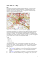
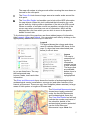
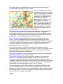
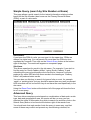
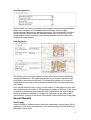
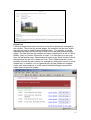
Somerset HER User Guide
INTRODUCTION
Computer considerations
2
2
Statement of Purpose and Conditions of Use
2
REGISTRATION
Passwords
2
3
ACCESSING ARCHAEOLOGICAL INFORMATION
3
VIEW SITES ON A MAP
Map
4
4
Tools
4
Legend
5
Search
6
SIMPLE QUERY (SEARCH BY SITE NUMBER OR NAME)
Site Number
8
8
Site Name
8
ADVANCED QUERY
Type of Record
8
9
Listed Building
9
Category
9
Period
10
Area
10
Area Designations
11
Grid Reference
11
SEARCH RESULTS
Details page
11
11
Result List
12
GLOSSARY
13
INDEX
14
1
Somerset HER User Guide
Introduction
The Somerset HER (Historic Environment Record) is an online database of all
known archaeological sites, events undertaken on them, scheduled
monuments, listed buildings, registered landscapes and historic landscape
character within the current county of Somerset.
There are several ways to search the HER varying from the simple to the
more complex. This document is intended to guide you through the various
methods in which Historic Environment information can be retrieved. The
features of each page that you may encounter within the HER are explained
in detail, step by step.
Computer considerations
The site has been designed to be accessible to as wide a range of people
with as wide a range of computer equipment as possible. Most of the site
uses plain text and images but the maps are generated using Macromedia
Flash. If this is not installed, you will be offered the opportunity to download a
plugin for your web browser. This is a very quick and easy operation but you
will have to close your browser and revisit the site to continue after download.
If you have Internet security programs installed they may intercept parts of the
site. In particular they may consider that the details windows are advertising
“pop-ups”. You may need to adjust the settings on your program to allow this
although we are confident that this problem has been resolved.
There also appears to be a problem when using Internet Explorer on
Macintosh computers as they do not display Flash properly. This is not a
problem with our site and we can only suggest that you try a different browser.
Statement of Purpose and Conditions of Use
Please take time to read the ‘Statement of Purpose’ to be found at the
beginning of this site. This contains important information on what the website
contains and information on copyright and conditions of use.
Registration
We hope that you will register as a user of the site. This will allow us to
assess the popularity of the site and the range of interests of the users. You
are welcome to use the site without registering but you will not be able to view
the maps in as great detail.
To register, click on Login at the top of the page. This will take you to the
Login page where you should click Register, which will bring up a simple form.
All we ask is a valid email address and two simple questions – where are you
and what is your area of interest. Once you have submitted this information, a
password will be sent to the email address and you can use this to login by
entering your email address and password on the Login Screen. Once you
have logged in to the site the computer will automatically log you in for each
individual session of use throughout that day.
2
Passwords
Once you have logged in successfully you can change your password to
something more memorable by choosing Change password on the Login
Screen. If you forget your password we will email it to the same email address
used when you registered.
Accessing Archaeological Information
Once you have logged in a range of options appears to access archaeological
information. These are:
You can click on the desired choice to be taken to the relevant screen. These
options are also always visible on every page on the top navigation bar as:
3
View Sites on a Map
Map
On entering this page the map should appear although it may take a few
seconds. The map can display several types of information drawn over
Ordnance Survey maps. When the map first appears it will automatically
default to display the area around Wells.
Immediately beneath the map are four numbers. These show the scale, the
width of the mapped area in metres and the National Grid easting (X) and
northing (Y) in metres. You can change these by clicking on them and typing
new values. Click on the set button to redraw the map. If you are not logged in
you will not be able to set the scale larger than 1:3800.
Tools
The first three tools enable you to navigate around the map and the last
accesses site details. To select a tool you should click the circle at the left of
each tool. Only one tool can be selected at a time – a black dot indicates
which is active.
The Centre tool enables you to move the map. If this tool is selected,
clicking on the map will redraw it so that the clicked point is at the
centre.
The Zoom In tool allows you to examine an area of the map at a larger
scale. You can either click and drag a rectangle to view, or just click.
4
The map will redraw at a larger scale either covering the area drawn or
centred on the click point.
The Zoom Out tool shows a larger area at a smaller scale around the
click point.
The View Site Details tool enables you to look at the HER information
for map objects. When this tool is selected the information for a site
can be seen by clicking within a depiction of the site of a HER record.
Where a number of records overlie one another a single click of the
cursor may select more than one set of information, which will be
displayed as a list from which you can click to move to the specific
details for each site.
To the bottom right of the map there are three tabbed pages of information
titled Legend, Layers and Search. You can select each one by clicking on the
appropriately labelled tab at the top of each one.
Legend
The legend shows the colours and styles
used to indicate different HER items on the
map. If a layer has been deselected (see
below) it will not show.
to you are listed here. The very
the background map
houses, roads, rivers and other
information.
Layers
The map is
composed of
layers of
information
overlain on top
of one another.
The layers that
are available
bottom layer is
displaying
topographical
The Sites and Monuments layer shows the location of archaeological sites,
archaeological events (excavations, surveys etc) and other features of the
historic environment. These can vary from findspots (shown as stars) to large
areas of field system or lengths of Roman road.
The Scheduled Monuments layer
shows items legally protected
under the Ancient Monuments
and Archaeological Areas Act.
The View Site Details tool will only
indicate the number and name in
the schedule; details of the
archaeological remains protected
can be found Sites and
Monuments Layer. Note: the
5
boundaries are our interpretation and should not be taken as definitive.
Contact English Heritage for further details.
The Listed Building layer shows
buildings and structures included
in the Lists of Buildings of Special
Architectural or Historic Interest
compiled by the Department for
Culture Media and Sport.
Important note: this layer is not
yet complete or checked
(although the text data is) and for
legal or planning purposes you
should talk to the Conservation
Officer at the District Council. In
particular the mapping does not
show the extent of the curtilage or structures within it.
The Registered Landscape layer shows land registered by English Heritage
as a Historic Park and Garden or Battlefield. Both types of registered
landscape are depicted as brown dotted areas; the info tool ( ) will provide
details. Note: the boundaries are our interpretation and should not be taken
as definitive. Contact English Heritage for further details.
The Conservation Areas layer shows all the Conservation Areas in the
County. These are designated by the local planning authority using the
‘Planning (Listed Buildings and Conservation Areas) Act 1990 and are valued
for ‘special architectural or historic interest’. They will have tighter controls
imposed through conservation policies on the extent and form of any
development that can undertaken
The Aerial Photography (1946) layer is vertical black and white aerial
photography taken by the RAF in 1946. Copies of most of the originals can be
seen at the Somerset Local Studies Library, the complete set is held in the
National Monuments Record in Swindon.
The Aerial Photography (2001)) layer comprises vertical colour photographs
taken for Somerset County Council in 2001.
The Historic Landscape layer is an attempt to characterise the historical
influences on the present day landscape. Clicking on an area will give
information on the estimated date of formation of the field patterns and a
suggestion of what the landscape was like before the present day field pattern
was established. It also provides an estimate of the amount of field boundary
loss that has occurred across the county in the 20th century.
You can turn layers on and off by clicking in the boxes to the left and then
clicking the display button beneath. However at least one of the Sites and
Monuments, Scheduled Monuments, Listed Buildings, Registered Landscape,
Conservation Areas or Historic Landscape layers must always be displayed if
Ordnance Survey mapping is displayed.
Search
6
This allows a map-based search to made using
geographical information such as postcode,
road name, place name and grid reference. At
the top is a drop down list, which enables you
to select which type of information to search
for. The options are Place Names, Post Codes,
Road Names and Grid References. Once the
type of search has been selected you should
type in what you are looking for and click
Search. The results will appear as a list, with a
maximum of 20 results, in the box below. To
move the map to one of the places listed,
select it in the list and then click the Show on
map button at the bottom. If you wish the map
to remain at the current scale tick the box marked Same Scale, otherwise the
resulting map will appear at a default scale.
Note that post codes should have a space between the two parts and that grid
references are in the format ST 123 456. You can use 4, 6 or 8 figure
references.
7
Simple Query (search by Site Number or Name)
This page allows a quick search for the textual information relating to sites
based on the Site Number (also known as the Primary Record Number
(PRN)) or part of a site name.
Site Number
If you know the PRN of a site, you can type it in the upper box. PRNs are
always five digits long. You can search for more than one PRN at a time
separated by commas. Then click on the Submit Query button at the bottom
right of the page. The results will appear on a separate page.
Site Name
This allows searches for words in the site name. For example, if you wish to
find the entry for ‘South Cadbury hillfort’, typing ‘South Cadbury’ in and
submitting the query should produce the correct site. However it will also
produce any other HER site with those words in the heading so “Cadbury
hillfort” will produce better results.
You can also use this box to search for types of site or event, for example
‘castle’ or ‘watching brief’ but you should be aware there may well be relevant
HER sites that will not be found if they do not have the word specifically in the
site name.
Using the Reset Form button at the bottom left of the page will clear the form
to run a new query.
Advanced Query
This form allows complex queries based on combinations of data such as site
type, date and geographical area. All queries will be run once you has
selected the types of information they wish to search for and then click on the
Submit Query button to be found at the bottom right of the search form.
You should note that each section limits the query in some way, and that
some of these may conflict and prevent any results being returned; for
8
example choosing a parish and a grid reference that lies outside the parish.
Within each section the choices are cumulative so that choosing ‘Castle’ and
‘Pillbox’ will search for both.
Type of Record
Choose if you would like to select HER
entries that are Events or Sites.
An Event is an act that has recorded, or
sought to locate, an archaeological site.
An event may therefore be an excavation, a survey, a watching brief or an
episode of field walking for example. An event may not always reveal
archaeological evidence but it will still be recorded in the HER to help indicate
the archaeological potential of an area. A Site is the physical location of
archaeological remains. Sites may vary in scale from the find spot of an
individual artefact such as a flint flake through to acres of a field system or
kilometres of an ancient road network.
Tick which of these you want included in your search.
Listed Building
Ticking these will include Listed Buildings in the search. There are three
grades of listing with Grade I being the most important.
Important Note: not all the Listed Buildings within Somerset have yet been
added to the HER and you should not rely on this information alone for
planning or legal work.
Category
Select from this box to limit your search to a particular type of monument, site,
building, object findspot or event. For example, you can search for all the ‘Fish
Traps’ and/or all the ‘Priories’. You will note that monument (which includes
buildings) terms are followed by (MON), object terms are followed by (OBJ)
and events by (EVE).
The list can be browsed using the up and down arrows located to the right of
the list or you can type in the first letter of the item and the list will jump to the
relevant section. You can choose more than one type by holding down the
Control key site and clicking.
9
The terms are hierarchical so that if you choose a general term such as
‘Factory’ you will get all the more detailed types as well.
The categories used are those given in English Heritage’s Thesaurus of
Monument Types (monuments and buildings), the Museum Documentation
Association’s Thesaurus of Archaeological Objects (finds) and our own list of
Event types.
Period
Select from this list to limit your search to a period or periods. Unfortunately
the list is alphabetical (rather than in date order). The periods are organised
as follows
BC – archaeological period names for example ‘Bronze age’
AD – centuries (C1, C20 etc) with overlapping archaeological period names
(medieval etc). The C19 is divided into decades and C20 and C21 into
individual years.
The names are again organised hierarchically so that choosing ‘C20’ will
include all ‘Second World War’ but not the other way around. As some sites
may not be well-dated, especially in earlier periods, it may be worth trying a
broad term such as “Prehistoric”.
Area
This list limits the search to specific local government areas (civil parishes and
districts).
10
Area Designations
This list limits the search to specific environmental and planning designated
areas such as Areas of Outstanding Natural Beauty, Areas of High
Archaeological Potential (for planning purposes), Environmentally Sensitive
Areas, and sites listed under the Ramsar convention. As these rely on us
being notified of their existence, we cannot guarantee that this search will
produce accurate results.
Grid Reference
This allows you to limit your search to area of the county that is defined by
using grid references. The upper part allows you to choose a specific map
point and an area around that point. The lower part allows you to define a
rectangular area of map to be searched by defining the top right and bottom
left corners.
Click on the Submit button to carry out the search. A new page will open with
the results which are limited to 100 arranged on pages of 10 each. If you need
to search for something that produces more, either divide the search up (by
parish or district for example) or contact us. The form can be cleared for a
new query by clicking on the Reset Form button at the bottom left of the page.
Search Results
Details page
Once a simple or advanced query has been submitted a results page will be
displayed. If the query produced only one result the page will open directly to
the details of that entry.
11
Result List
If several results have been found then a list will be displayed, arranged by
site number. There may be several pages, the numbers can be seen at the
top right and can be used to move between them. The number of results
displayed per page can be defined on both the simple and advanced query
pages. The lists give the site number and name together with a link to “Show
details” (text) or a button “Show site on map”. You can also go to the map
from the site details page. Sometimes this button says “Show location” which
indicates that the site is not drawn on map. This is either because it is not
possible to locate the site exactly (for example an antiquarian record of a find
located only to a parish, or it is a general entry whose details are mapped
under their own numbers) or in the case of Listed Buildings, because the
maps have not yet been drawn.
12
At the bottom right of the list there is an option to “Show all site details on this
page”. If this is chosen then a continuous list of all the site details will be
displayed in a single window. This is mostly useful to print out multiple entries.
A maximum of 1000 records will be shown for an individual search. If your
search results exceed this limit you will be informed and should undertake
more, narrowly defined searches.
Glossary
Ancient Monument: see Scheduled Monument.
Conservation Area: an area designated under the Planning (Listed Buildings
and Conservation Areas) Act 1990. Certain works which would alter the
character of the area require Conservation Area Consent from the local
planning authority. Planning permission may also be required.
Listed Building: a structure protected under the Planning (Listed Buildings
and Conservation Areas) Act 1990. Works that would alter the character of
the structure require Listed Building Consent from the local planning authority.
Planning permission may also be required.
Scheduled Monument (also known as Scheduled Ancient Monument or
Ancient Monument): a human construction (above or below ground) that is
protected under the Ancient Monuments and Archaeological Areas Act 1979.
It is an offence to damage or carry out works to Scheduled Monuments
without written consent from the Secretary of State for Culture, Media and
Sport. English Heritage advises the Secretary of State and should be
contacted in the first instance. It is also an offence to use a metal detector on
a Scheduled Monument without a licence from English Heritage.
AONB: an Area of Outstanding Natural Beauty where there are additional
planning controls to protect the countryside.
ESA: an Environmentally Sensitive Area where landowners can obtain
payments for environmental works.
Ramsar site: a designation under the Ramsar Convention indicating
international wildlife importance.
13
Index
A
Aerial Photography (1946), 6
Aerial Photography (2001), 7
AONB, 13
Area Designations, 11
M
Maps, 4
Searching, 7
Tools, 5
Monument, 9
B
Battlefields, 6
Building, 9
O
Object, 9
P
C
Change password, 3
Conservation Area, 13
Conservation Areas, 6
D
Details page, 11
District, 10
Parish, 10
Passwords, 3
Period, 10
Place Name, 7
Post Code, 7
PRN, 8
Problems, 2
Q
E
ESA, 13
Event, 9
Query
Advanced, 8
Simple, 8
R
F
Findspot, 9
Flash, 2
G
Grid Reference, 7, 11
Ramsar, 13
Register, 2
Registered Landscape, 6
Result List, 12
Road Name, 7
S
H
Historic Landscape, 7
Historic Parks, 6
L
Layers, 5
Legend, 5
Listed Building, 6, 9, 13
Login, 2
Scheduled Monument, 13
Scheduled Monuments, 6
Site, 9
Site Name, 8
Site Number, 8
T
Tool, 5, 6
14