1
.
3.1.6
Navigation Circle
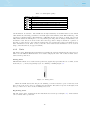
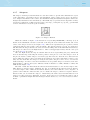
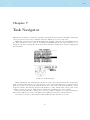
The Navigation Element is a multi-information element which shows graphically the bearing, wind
direction and thermal core. Additionally, if a destination was defined (waypoint) the navigation
element will also indicates the direction to the waypoint center, the waypoint edge and the direction
to the waypoint after the next one. This element cannot be resized but can be re-positioned.
For navigation information to be displayed the LIVE must have a valid GPS fix.
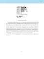
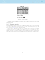
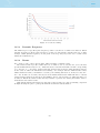
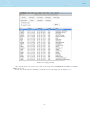
Figure 3.5: Navigation Element
Navigation information is shown within the inner most circles. The external circle contains the
cardinal points. The current traveling direction (bearing) corresponds to the point indicated in the
top of the navigation circle. On the example shown in Figure 3.5, the bearing is approximately
260º.
Navigation Arrows
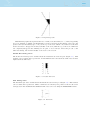
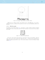
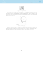
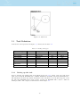
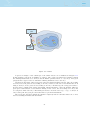
When a route is active the direction of next optimal point is pointed by an arrow(larger arrow). The
optimal point corresponds to the unique point on the waypoint cylinder which lies along the optimal
route (red route in the Figure 3.6 example). If no route is defined the arrow will start showing the
direction to the takeoff, after the takeoff is detected, i.e. the average speed exceeds 5km/h.
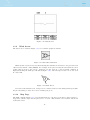
During a competition task flight using the optimal tangent navigation saves a substantial amount
of time. The smaller arrow closer to the centre of the navigation wheel points to the centre of next
waypoint cylinder, and the arrow furthest away from the centre of the navigation wheel points to
the optimised edge of the waypoint after the next one. The combination of all three arrows provides
a spatial location of the waypoint.
Figure 3.6: Route Optimisation
14