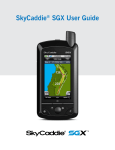
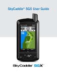
1
MAP 330 and MAP 330M
2
Product:
Map330
Question:
Answer:
3
Product:
Map330,
Map330M
Question:
Answer:
4
Product:
Map330,
Map330M
Question:
Answer:
5
Product:
Map330,
Map330M
Question:
Answer:
6
Product:
Map330,
Map330M
Question:
Answer:
7
Product:
Map330,
Map330M
Question:
Answer:
8
Product:
Map330,
Map330M
Question:
Answer:
9
Product:
Map330,
Map330M
Question:
How many batteries are required for MAP 330?
MAP 330 uses two AA batteries that are installed from the back
through the battery cover.
If I am using fresh batteries how long will my GPS stay on?
You have up to 10 hours of usage on two fresh AA batteries with the
backlight turned off.
How much time do I have to replace the batteries before I loose
waypoints?
Any waypoints or routes you have created are stored in permanent
memory and should not be lost for months with the batteries
removed. Present position and time data is not stored in permanent
memory, but will be held in memory for at least two hours without
batteries installed.
How do I connect the wrist strap to my GPS?
The wrist strap attaches to the ring on the screw for the battery door
cover
Does the MAP 330 or MAP 330M come with a power or data cable?
No. You must purchase it separately.
How do I adjust contrast in MAP 330 and MAP 330M?
Press the menu button, then use the up/down arrows to highlight
contrast and then use the left/right arrow to adjust the contrast.
How many navigation screens does MAP 330 and 330M have?
The Map 330 and 330M have seven navigation screens: Map
screen, compass screen, large data screen, position screen, sat
status screen, Speedometer screen and the road screen. The NAV
button provides a means of accessing the navigation screens.
How do I save a Waypoint with a receiver-generated name?
Answer:
10
Product:
Map330,
Map330M
Question:
Answer:
11
Product:
Map330,
Map330M
Question:
Answer:
12
Product:
Map330,
Map330M
Question:
Answer:
13
Product:
Map330,
Map330M
Question:
From any screen, press and hold the mark button for two seconds
and the mark screen is displayed. The “save” button is highlighted
and you can press enter to save the waypoint using the default name
and icon.
How do I save a waypoint with a user-input name?
From any screen, press and hold the mark button for two seconds.
Use the up/down arrows and notice that the highlight moves from
field to field and then back to “save.” Highlight the Icon field using the
up/down arrows. Press enter.
Is there a limit to the number of waypoints I can store in the MAP
330 and the MAP 330M?
Yes, the MAP 330 and 330M will store up to 500 user waypoints in
memory.
Why is my GPSnot allowing me to create a message for waypoints?
With the MAP 330 you can only create messages or 200 waypoints.
If you should ever get that many and need to input more, to make
room you will have to delete ones that you no longer need.
How do I create a GOTO route?
The two ways to create a GOTO route are the following:
Answer:
Creating GOTO using destination waypoint from “Near
Position”
Press GOTO. Use the UP/DOWN arrows to highlight the
category that your destination waypoint is in. Use the left/right arrows
to select near position. Use the up/down arrows to highlight your
choice of waypoint to be your destination and press enter. The
GOTO route is now active and you are returned to the last viewed
navigation screen.
Creating a destination waypoint from the database using
“Alphabetical”
Press GOTO. Use the up/down arrows to highlight the
category that your destination waypoint is in. Use the left/right arrows
to select “Alphabetical”. Use the up/down arrows to highlight your
choice of waypoint to be your destination and press enter. The
GOTO route is now active and you are returned to the last viewed
navigation screen
14
Product:
Map330,
Map330M
Question:
Answer:
15
Product:
Map330,
Map330M
Question:
Answer:
How do I turn on the display waypoint on map screen?
From map screen press the menu button highlight map setup and
use the arrow to select the “display waypoints “and press enter. Use
the arrow to select on and press enter and nav button.
How do I change map orientation from north up to course up?
From map screen press menu button highlight map setup and use
the arrow to select the “orientation“ and press enter. Use thearrow to
select on, press enter and nav button.
16
Product:
Map330,
Map330M
Question:
Answer:
17
Product:
Map330,
Map330M
Question:
Answer:
18
Product:
Map330,
Map330M
Question:
Answer:
19
Product:
Map330,
Map330M
Question:
Answer:
20
Product:
Map330,
Map330M
Question:
Answer:
21
Product:
Map330,
Map330M
Question:
Answer:
22
Product:
Map330,
Map330M
Question:
Answer:
23
Product:
Map330,
Map330M
Question:
Answer:
24
Product:
Map330,
Question:
How do I clear track in my GPS?
From map screen press the menu button, highlight clear track, and
press enter. Click on confirm and press enter.
How do I reset the trip odometer?
Press the nav button to get the position screen and press the
menu button and highlight reset trip and click on yes and press
enter.
What information I can get from the satellite screen?
Thes The satellite status screen visually displays the satellites being
used and the strength of the received signal. Additionally, this screen
displays the power source you are connected to and, if internal
batteries, how much battery life is remaining.
How do I access a waypoint in my GPS?
Press the menu button and highlight database and press enter. Use
the up/down arrows to select category. Use the left/right arrow to
select “find by” and press enter. You can find the waypoint by
selecting waypoints from the nearest list and selecting waypoints
from the Alphabetical list.
How do I save my present location?
From any screen press and hold the mark button for a few seconds.
You can change the name and put the message in the GPS.
How do I manually create waypoint?
From any screen press and hold the mark button and highlight the
location field and press enter. Edit line 1 of the location field and
press enter. Also Edit line 2 of the location field and press enter. Edit
elevation field and press enter. If you want to enter a message you
can modify it. Highlight save button.
How do I delete a waypoint in my GPS?
From any menu button highlight database. Press enter and highlight
user. Use the left/right arrow to select by “find by” and press enter.
Select waypoint to delete and press menu. Highlight delete wpt
,press enter, confirm yes and enter.
Can I use MapSend Street and Destination in MAP 330M?
Yes you can use Magellan MapSend Streets.
How do I create a route in MAP 330 and in MAP 330M?
Map330M
Answer:
25
Product:
Map330,
Map330M
Question:
Answer:
26
Product:
Map330,
Map330M
Question:
Answer:
27
Product:
Map330,
Map330M
Question:
Answer:
28
Product:
Map330,
Map330M
Question:
Answer:
29
Product:
Map330,
Map330M
Question:
Answer:
30
Product:
Map330,
Map330M
Question:
Answer:
31
Product:
Map330,
Map330M
Question:
Answer:
32
Product:
Map330,
Map330M
Question:
Answer:
33
Product:
Question:
From any menu button highlight database and press enter. Highlight
upload map region and press enter. Highlight address and press
enter. Use the arrows to enter street name press enter.
How do I create a back route in MAP 330 and in MAP 330M?
From any screen press, the menu button. Highlight routes and press
enter. Select “backroute” from route list and press enter. Highlight
activate backrt and press enter.
How do I activate the route in MAP 330 and in MAP 330M?
From any menu button highlight routes and press enter. Highlight
select route and press menu. Highlight activate routes and press
enter.
How do I view a route in my GPS?
From any menu button highlight routes and press enter. Highlight
select route and press menu. Highlight view/edit route and press
enter.
How do I delete a route in my GPS?
From any menu button highlight routes and press enter. Highlight
select route and press menu. Highlight delete route and press enter.
How do I view a route on map screen?
From any menu button highlight routes and press enter. Highlight
select route and press menu. Highlight map view route and press
enter.
How do I initialize the MAP 330 and the MAP 330M?
Press the menu button from any screen. Highlight setup and press
enter. Highlight initialize and press enter. Highlight region and press
enter. Highlight area and press enter again. Input date and time and
press enter twice.
What are the default primary and secondary co-ordinate systems in
MAP 330 and in 330M?
Primary - Lat/Lon DEG.MIN.MMM
Secondary – UTM
How can I change the co-ordinate system in MAP 330 and 330M?
From any screen press the menu button highlight setup and press
enter. Highlight co-ordinate system and press enter. Select primary
or secondary and press enter. Select co-ordinate system and press
enter.
What is the default map datum in MAP 330 and in 330M?
Map330,
Map330M
Answer:
34
Product:
Map330,
Map330M
Question:
Answer:
35
Product:
Map330,
Map330M
Question:
Answer:
36
Product:
Map330,
Map330M
Question:
Answer:
37
Product:
Map330,
Map330M
Question:
Answer:
38
Product:
Map330,
Map330M
Question:
Answer:
39
Product:
Map330,
Map330M
Question:
Answer:
40
Product:
Map330,
Map330M
Question:
Answer:
41
Product:
Map330,
Map330M
Question:
Answer:
Default: Primary - WGS84 Secondary - WGS84
How do I change map datum in MAP 330 and in330M?
From any screen press the menu button, highlight setup, and press
enter. Highlight map datum and press enter. Select primary or
secondary and press enter. Select map datum and press enter.
How do I change the elevation mode in MAP 330 and in 330M?
From any screen press the menu button, highlight setup, and press
enter. Highlight eleve mode and press enter. Select 2D and press
enter.
How do I change the time format in MAP 330 and in330M?
From any screen press the menu button, highlight setup, and press
enter. Highlight time format and press enter. Select format and press
enter. If local time is selected (24 hour. or AM/PM) you will be
prompted to enter your local time.
How can I change the nav units from KM/KPH to miles/MPH?
From any screen press the menu button, highlight setup, and press
enter. Highlight nav units and press enter. Select miles/MPH and
press enter.
What is the default elevation mode?
3D
How do I select the backlight timer in MAP 330 and in330M?
From any screen press the menu button, highlight setup, and press
enter. Highlight light timer and press enter. Select time duration and
press enter. Time duration: 30 seconds, 1 minute, 2 minutes, 4
minutes, 10 minutes.
What is the default Baud rate for MAP 330 and 330M?
4800 Baud.
How do I change the Baud rate in MAP 330 and in 330M?
From any screen press the menu button, highlight setup, and press
enter. Highlight Baud rate and press enter. Select Baud rate and
press enter. You can choose 1200 Baud, 4800 Baud, 9600 Baud or
1920 Baud.
42
Product:
Map330,
Map330M
Question:
Answer:
43
Product:
Map330,
Map330M
Question:
Answer:
44
Product:
Map330,
Map330M
Question:
Answer:
46
Product:
Map330,
Map330M
Question:
Answer:
47
Product:
Map330,
Map330M
Question:
Answer:
48
Product:
Map330,
Map330M
Question:
Answer:
49
Product:
Question:
How do I clear memory in MAP 330 and in 330M?
From any screen press the menu button, highlight setup, and press
enter. Highlight clear memory and press enter. Select the choice and
press enter. Confirm yes and press enter.
Clearing Track History
Clearing Wpts/Routes
Clearing all Routes
How can I clear all memory in MAP 330?
From any screen press the menu button, highlight setup, and press
enter.
Highlight clear memory and press enter.
Highlight all and press enter...
Confirm yes and press enter.
Your GPS will turnoff.
How do I access the sun/moon screen?
Press menu and highlight sun/moon and press enter.
What information can I get from the about screen?
The ”about” screen displays the status of MAP 330 and MAP
330M.Using the about screen you can tell what the version of the
software is, the version and memory size of the base map, the
number of and total memory size of detailed maps you may have
installed using MapSend Street, and how much free memory is
available.
What is the difference between degrees/minutes/seconds
(DEG/MIN/SEC) and degrees/minutes/minutes (DEG/MIN/MMM or
DEG/MIN/MM)?
There are different ways to express the coordinates computed using
latitude/longitude coordinate system. With DEG/MIN/SEC the final
set of numbers (SEC) is expressed as 0-59 while DEG/MIN/MM
expresses the same value as 0-99 and DEG/MIN/MMM is from 0999. It would be the same as if you had one clock that expressed
time as hour/minutes/seconds and another clock that expressed the
same time as hours/minutes/decimals. The accuracy for any of the
three is the same.
When the time changes for daylight savings will the time in your GPS
change automatically?
No. The time transmitted by the satellites atomic clock is UTC
(Universal Time Coordinated) and provides no correction for daylight
savings. When daylight savings time changes (or when you move to
a new time zone), you need to go into setup —time format and reselect the time format you are using unless you are using UTC. After
selecting the format you will be given the opportunity to change the
time.
What waypoints come preloaded on my MAP 330database?
Map330
Answer:
50
Product:
Map330,
Map330M
Question:
Answer:
51
Product:
Map330,
Map330M
Question:
Answer:
52
Product:
Map330,
Map330M
Question:
Answer:
53
Product:
Map330,
Map330M
Question:
Answer:
54
Product:
Map330,
Map330M
Question:
Answer:
59
Product:
Map330,
Map330M
Question:
Answer:
60
Product:
Map330,
Map330M
Question:
Answer:
61
Product:
Map330,
Map330M
Question:
The Map 330 database contains cities, highways, airports,
waterways, and national parks.
Can I delete preloaded waypoints that I don’t use?
No. Waypoints that are preloaded into the MAP 330 will always be
available, even when all of the MAP 330’s memory has been
cleared.
Why does my compass not point in the right direction?
For that you should be moving at a minimum of 2.0 mph for the
compass to compute the direction properly.
What is a backtrack route?
A backtrack route allows you to “retrace” your steps. As you are
moving, the MAP 330 automatically creates and stores hidden
waypoints into memory. These waypoints are the ones that the MAP
330 will use to retrace your steps. When you create a backtrack
route, the MAP 330 converts these hidden waypoints into user
waypoints
How do I know which route is active?
Access the route menu by pressing the menu button and select the
option routes. The route menu lists all of the routes in memory with
the active route displayed in bold characters.
Why does my MAP 330 and 330M not make an audible beep when I
have an alarm active?
Check your setup settings for the Beeper. If the selection is off or
keys only, the beeper will not sound for alarms.
What can I do if the receiver will not turn on?
1. Check to see if the batteries are installed correctly.
2. Replace with two new AA alkaline batteries.
My GPS takes more than 10 minutes to get the position. What can I
do?
If there are any obstacles nearby or overhead, move to a new
location. Make sure that the antenna is pointing up, has a clear view
of the sky and is a reasonable distance away from your body.
Check satellite status screen to see where the satellites are and if
the receiver is acquiring data. If the receiver still does not get a
position fix within 10 minutes, you may wish to repeat the
initialization procedure.
Why does my GPS Receiver turn off unexpectedly?
Answer:
62
Product:
Map330,
Map330M
Question:
Answer:
63
Product:
Map330,
Map330M
Question:
Answer:
64
Product:
Map330,
Map330M
Question:
Answer:
66
Product:
Map330,
Map330M
Question:
Answer:
67
Product:
Map330,
Map330M
Question:
Answer:
69
70
Product:
Map330,
Map330M
Product:
Map330,
Map330M
71
Battery life seems shorter than it should be. What can I do?
Make sure that you are using two AA alkaline batteries.Shorter life
span of the batteries can be due to excessive use of the backlight.
Turn the backlight off when not needed.
Why do the position coordinates on my receiver not match the
location on my
map.
Make sure that your receiver is set up to use the same datum as
your map. The map datum is generally shown in the map legend.
2. Check your latitude/longitude format. Make sure that the format
selected in coordinate system (DEG/MIN/SEC or DEG/MIN.MM) is in
the same format as the map you are using.
Why is the position on a map not exactly the position on a road?
This could be caused by distance shifts to the map. Use map data
for reference, but do not rely completely on it.
What is the temperature range in my MAP 330 and MAP 330M?
Operating 14˚F to 140˚F to (-10˚C to 60˚C)
Storage -4˚F to 158˚F (-20˚C to 70˚C)
What is the function of the MapSend Street in my MAP 330??
The MapSend Streets CD allows you to load detailed street maps
into your MAP 330. The maps supplied on the MapSend Streets CD
contain full street detail of US cities.
Question:
How do I check the trip odometer in my MAP 330 and MAP 330M?
Answer:
Press the nav button to get the position screen. At the bottom of the
page you can get the trip odometer.
Question:
Answer:
Product:
Map330,
Map330M
Excessive static electricity Is a common cause for this problem. Turn
the receiver back on and it should operate normally. Move the
receiver to a new location to avoid a similar occurrence.
Question:
Answer:
What is the difference between MAP 330 and MAP 330M?
MAP 330M has fixed nvaids which include buoys, lighthouses,
Marinas, and obstructions (wrecks, rocks, and so forth.). These
navaids can
be accessed through the database in the same manner that any
other waypoint or map object can be accessed using the database
function.
Where is GOTO route stored?
GOTO routes are NOT saved in memory when the MAP 330 is
turned off. If you are navigating on a GOTO route and you need to
turn the MAP 330 off, you will need to restart the GOTO. Routes,
however, are stored in memory. If you need to make a GOTO but
expect to turn your MAP 330 off before arriving, you might consider
making a one-leg route using the route menu. More information on
routes can be found in the reference chapter of this manual.
72
Product:
Map330,
Map330M
Question:
Answer:
73
Product:
Map330,
Map330M
Question:
Answer:
74
Product:
Map330,
Map330M
Question:
Answer:
75
Product:
Map330,
Map330M
Question:
Answer:
How do I check the battery life of MAP 330 and MAP 330M?
Press the nav button so that you can get the satellite status screen.
This is where you can check the battery life indicator.
How do I change the primary usage from land to marine?
As a default, the MAP 330 is in the “land mode.” From the Map
screen press menu. Highlight map set up and press enter. Highlight
primary usage and press enter. Use up/down arrows to select
marine and press enter.
Can I purchase a hard copy of the user manual?
No. However ,you can download the user manual at no charge
and print the pages that you need. Use this link to get the manual.
http://www.magellangps.com/support/product.asp?prodid=92
Can I use an external power source to MAP 330 and MAP 330M?
Yes.