1
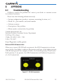
GDL 88
ADS-B Transceiver
Pilot’s Guide
© 2012 Garmin Ltd. or its subsidiaries. All rights reserved.
This manual reflects the operation of System Software version 2.00, or later. Some differences in operation
may be observed when comparing the information in this manual to later software versions.
Garmin International, Inc., 1200 East 151st Street, Olathe, KS 66062, U.S.A.
Tel: 913/397.8200
Fax: 913/397.8282
Garmin AT, Inc., 2345 Turner Road SE, Salem, OR 97302, U.S.A.
Tel: 503/391.3411
Fax 503/364.2138
Garmin (Europe) Ltd., Liberty House, Bulls Copse Road, Hounsdown Business Park, Southampton, SO40
9RB, U.K.
Tel. +44 (0) 870 850 1243 Fax +44 (0) 238 052 4004
Garmin Corporation, No. 68, Zhangshu 2nd Road, Xizhi Dist., New Taipei City 221, Taiwan (R.O.C.)
Tel: 886/02.2642.9199
Fax: 886/02.2642.9099
Garmin Singapore Pte. Ltd., 46 East Coast Road, #05-06 Eastgate, Singapore 428766
Tel : (65) 63480378
Fax : ( 65 ) 63480278
At Garmin, we value your opinion. For comments about this guide, please e-mail:
[email protected]
www.garmin.com
https://fly.garmin.com/fly-garmin
Except as expressly provided herein, no part of this manual may be reproduced, copied, transmitted,
disseminated, downloaded or stored in any storage medium, for any purpose without the express written
permission of Garmin. Garmin hereby grants permission to download a single copy of this manual and of
any revision to this manual onto a hard drive or other electronic storage medium to be viewed for personal
use, provided that such electronic or printed copy of this manual or revision must contain the complete text
of this copyright notice and provided further that any unauthorized commercial distribution of this manual or
any revision hereto is strictly prohibited.
This part shall comply with Garmin Banned and Restricted Substances document, 001-00211-00.
Garmin® is a registered trademarks of Garmin Ltd. or its subsidiaries. These trademarks may not be used
without the express permission of Garmin.
October 2012
Printed in the United States
WARNING: For safety reasons, GDL 88 operational procedures must be
learned on the ground.
WARNING: This unit provides the ability to receive weather information
through external sources. Use weather data only as an aid to situational
awareness. Such weather information is merely supplemental and advisory
in nature and is not intended to be relied upon as safety-critical information
in connection with any aviation, vehicle, or marine usage. The user should
always exercise caution and common sense when confronted with severe
weather conditions.
WARNING: Do not use data link weather information for maneuvering in,
near, or around areas of hazardous weather. Information contained within data
link weather products may not accurately depict current weather conditions.
WARNING: Traffic information is provided as an aid in visually acquiring
traffic. Pilots must maneuver the aircraft based only upon ATC guidance or
positive visual acquisition of conflicting traffic.
CAUTION: The Garmin GDL 88 does not contain any user-serviceable
parts. Repairs should only be made by an authorized Garmin service center.
Unauthorized repairs or modifications could void both the warranty and the
pilot’s authority to operate this device under FAA/FCC regulations.
NOTE: All visual depictions contained within this document, including images
of the GDL 88 and the bezel, displays, and screens of other products are
subject to change and may not reflect the most current software or hardware.
Depictions of equipment may differ slightly from the actual equipment.
NOTE: This device complies with part 15 of the FCC Rules. Operation is
subject to the following two conditions: (1) this device may not cause harmful
interference, and (2) this device must accept any interference received,
including interference that may cause undesired operation.
NOTE: This product, its packaging, and its components contain chemicals
known to the State of California to cause cancer, birth defects, or reproductive
harm. This notice is being provided in accordance with California’s Proposition
65. If you have any questions or would like additional information, please
refer to our web site at www.garmin.com/prop65.
190-01122-03 Rev. A
GDL 88 ADS-B Transceiver Pilot’s Guide
i
NOTE: This device complies with Part 15 of the FCC limits for Class B digital
devices. This equipment generates, uses, and can radiate radio frequency
energy and, if not installed and used in accordance with the instructions,
may cause harmful interference to radio communications. Furthermore, there
is no guarantee that interference will not occur in a particular installation.
If this equipment does cause harmful interference, the user is encouraged
to try to correct the interference by relocating the equipment or connecting
the equipment to a different circuit than the affected equipment.
Consult an authorized dealer or other qualified avionics technician
for additional help if these remedies do not correct the problem.
Operation of this device is subject to the following conditions: (1) This
device may not cause harmful interference, and (2) this device must accept
any interference received, including interference that may cause undesired
operation.
ii
GDL 88 ADS-B Transceiver Pilot’s Guide
190-01122-03 Rev. A
Record of Revisions
Part Number Revision Date
Description
190-01122-03
A
10/19/12 Initial release
190-01122-03 Rev. A
GDL 88 ADS-B Transceiver Pilot’s Guide
iii
To obtain accessories for your unit, please contact your Garmin dealer.
Help us better support you by completing our on-line registration form today!
Registration ensures that you will be notified of product updates and new
products and provides lost or stolen unit tracking. Please, have the serial
number of your unit handy, connect to our web site (www.garmin.com or
https://fly.garmin.com/fly-garmin) and look for our Product Registration link
on the Home page.
iv
GDL 88 ADS-B Transceiver Pilot’s Guide
190-01122-03 Rev. A
Contents
1Introduction..........................................................................................1-1
1.1 GDL 88(D) System Functions................................................................. 1-1
1.2 GDL 88 Part Numbers........................................................................... 1-2
2
2.1
2.2
2.3
2.4
3
ADS-B System Overview.......................................................................2-1
ADS-B - Broadcast (ADS-B)................................................................... 2-3
Automatic Dependent Surveillance – Rebroadcast (ADS-R).................... 2-4
Traffic Information Service - Broadcast (TIS-B)........................................ 2-5
Flight Information Service – Broadcast (FIS-B)........................................ 2-6
GDL 88 ADS-B Out.................................................................................3-1
3.1 GDL 88 ADS-B Out Data....................................................................... 3-1
3.2Self-Interrogation.................................................................................. 3-2
3.3 Pressure Altitude Broadcast Inhibit (PABI).............................................. 3-2
3.4 Anonymous Mode................................................................................ 3-3
3.5 Air/Ground Determination..................................................................... 3-3
4
GDL 88 ADS-B IN...................................................................................4-1
4.1 GDL 88 ADS-B In Data.......................................................................... 4-1
4.2Traffic................................................................................................... 4-2
4.2.1
Traffic Applications – SURF, AIRB, etc....................................... 4-2
4.2.2
GDL 88 Integration with TCAD/TAS/TCAS I.............................. 4-5
4.2.3
No-Heading Source Traffic Information.................................... 4-6
4.2.4
Conflict Situational Awareness (CSA)...................................... 4-6
5Weather................................................................................................5-1
5.1FIS-B NEXRAD...................................................................................... 5-2
5.1.1
NEXRAD Abnormalities........................................................... 5-3
5.1.2
NEXRAD Limitations............................................................... 5-3
5.1.3
NEXRAD Intensity................................................................... 5-4
5.1.4
NEXRAD................................................................................ 5-4
5.2
FIS-B TFRs.............................................................................. 5-5
5.3
FIS-B METARs......................................................................... 5-5
5.4
FIS-B PIREPs........................................................................... 5-5
5.5
FIS-B Winds and Temperatures Aloft........................................ 5-6
5.6
SIGMETs and AIRMETs........................................................... 5-6
190-01122-03 Rev. A
GDL 88 ADS-B Transceiver Pilot’s Guide
v
6
Installation configurations....................................................................6-1
6.1 Possible Installation Configurations....................................................... 6-1
6.1.1
GDL 88 with ADS-B Out Transmission Enabled........................ 6-1
6.1.2
GDL 88 with ADS-B Out Transmission Disabled........................ 6-1
6.1.3
GDL 88 Only – No Display...................................................... 6-1
6.2Interfaces............................................................................................. 6-2
6.2.1
Audio Panel........................................................................... 6-2
6.2.2
Altitude Source....................................................................... 6-2
6.2.3
TAS and TCAS Traffic Systems.................................................. 6-2
6.2.4
Heading Source (optional)...................................................... 6-2
6.2.5
GPS Position Source............................................................... 6-2
6.2.6
Radar Altimeter (Optional)...................................................... 6-2
6.2.7
Traffic Mute (Optional)............................................................ 6-2
7Glossary................................................................................................7-1
8Appendix...............................................................................................8-1
8.1Troubleshooting.................................................................................... 8-1
8.2 Servicing Your Unit................................................................................ 8-2
8.3 Contact Garmin.................................................................................... 8-2
8.4 Software License Agreement................................................................. 8-3
8.5 LIMITED WARRANTY............................................................................ 8-4
Index......................................................................................................Index-1
vi
GDL 88 ADS-B Transceiver Pilot’s Guide
190-01122-03 Rev. A
1INTRODUCTION
The GDL 88 is a remotely mounted ADS-B transceiver. There are four models
of the GDL 88(D). Models with a single bottom mounted UAT antenna meet TSO
C154c Class A1S and are available with or without an internal GPS/SBAS receiver.
Models with one top mounted and one bottom mounted antenna meet TSO C154c
Class A1H and are also available with or without an internal GPS/SBAS receiver.
1.1
GDL 88(D) System Functions
The GDL 88 performs the following functions:
• UAT transmission (978 MHz)
The GDL 88 transmits ADS-B Out data on the 978 MHz (UAT) frequency
to be received by other aircraft, vehicles, and ATC for situational
awareness and traffic management.
• UAT reception (ADS-B, ADS-R, TIS-B, and FIS-B) on 978 MHz
The GDL 88 receives ADS-B data transmitted on the UAT link from
other aircraft, vehicles, and ground stations to present a traffic situational
awareness display for use by the flight crew. In addition, the GDL 88
receives FIS-B data on the UAT link to provide the flight crew with
graphical and textual weather products.
• Mode-S Extended Squitter reception on 1090 MHz
The GDL 88 receives ADS-B data transmitted by aircraft on the 1090 MHz
link to provided a comprehensive situational awareness traffic display for
use by the flight crew.
• Correlation of traffic reports from multiple traffic sources, including no
heading source installations
The GDL 88 is capable of interfacing with TCAD/TAS/TCAS I systems
to create and present a “fused” situational awareness display to the flight
crew.
• Output of ADS-B and TAS/TCAS I traffic data to an external display
The GDL 88 is capable of providing a situational awareness traffic display
on compatible displays.
• Output of FIS-B weather data to an external display
The GDL 88 is capable of providing various textual and graphical weather
190-01122-03 Rev. A
GDL 88 ADS-B Transceiver Pilot’s Guide
1-1
products for display on compatible displays.
• Traffic alerting
The GDL 88 provides aural and visual cues of impending traffic conflicts,
to include directional aural (“Traffic, Traffic, Two O’clock, Two Miles,
Low”).
• Single point of entry for transponder squawk code, IDENT, and
emergency status
1.2
GDL 88 Part Numbers
Part Number
010-00859-30
Description
GDL 88
010-00860-30
010-00861-30
010-00862-30
GDL 88, Internal WAAS with install kit
GDL 88 Diversity with install kit
GDL 88 Diversity, Internal WAAS with install kit
Table 1-1 GDL 88 Configurations
1-2
GDL 88 ADS-B Transceiver Pilot’s Guide
190-01122-03 Rev. A
2
ADS-B SYSTEM OVERVIEW
ADS-B is a core technology in the FAA Next Gen air traffic control system and is comprised of three segments: ADS-B (Broadcast), ADS-R (Rebroadcast), and
TIS-B.
Nearly 400 ADS-B ground stations were completed and operational by mid2012, with most of the rest — totaling more than 700 planned stations —
expected to be operational by early 2014. The graphic below illustrates where
ADS-B is currently operational. In the areas highlighted in blue, you can already
start taking advantage of ADS-B’s datalink traffic and subscription-free weather
services if you’re equipped with an ADS-B “In” solution.
Figure 2-1 ADS-B Ground Stations (mid-2012) - FAA Illustration
190-01122-03 Rev. A
GDL 88 ADS-B Transceiver Pilot’s Guide
2-1
Figure 2-2 ADS-B Coverage vs Altitude (Planned for 2014) - FAA Illustration
2-2
GDL 88 ADS-B Transceiver Pilot’s Guide
190-01122-03 Rev. A
2.1
ADS-B - Broadcast (ADS-B)
ADS-B is the automatic broadcast of position reports by aircraft, surface
vehicles, and transmitters on fixed objects. These broadcasts contain much more
data than just a simple position report, they include: identity (Flight ID, Call
Sign, Tail Number, ICAO registration number, etc), ground track, ground speed,
pressure altitude, indications of multitude capabilities, and emergency status. This
list of data is non-inclusive of other data fields and bits used for various other
functions.
Figure 2-3 ADS-B Operation - FAA Illustration
Garmin display units have the capability to show the status of the ground station
services being received. Examples for the GTN and GNS products are shown below.
See the display device Pilot Guide for the symbology used on that display.
Unit
Symbol
GNS
GNS
GNS
GTN
GTN
Description
Within coverage of a TIS-B ground station when connected
to a GDL 88.
Not within coverage of a TIS-B ground station when
connected to a GDL 88.
GDL 88 does not have a valid track or heading and cannot
place ADS targets on the display.
Within coverage of a TIS-B ground station when connected
to a GDL 88.
Not within coverage of a TIS-B ground station when
connected to a GDL 88
Table 2-1 Map TIS-B Availability Symbols
190-01122-03 Rev. A
GDL 88 ADS-B Transceiver Pilot’s Guide
2-3
2.2
Automatic Dependent Surveillance –
Rebroadcast (ADS-R)
Because it is not required that ADS-B In capable aircraft be able to receive
ADS-B data on both the 1090 MHz and 978 MHz data links, a means to get data
from one data link to the other is required. ADS-R is the rebroadcast of ADS-B data
by FAA ground stations and provides this service by taking data from one link and
rebroadcasting it on the other. For example, two aircraft are in the service volume
for a ground station, and one transmitting on 1090 MHz and the other 978 MHz,
the ground station will retransmit the data from each aircraft on the other link to
ensure the two aircraft can “hear” each other.
Figure 2-4 ADS-R Operation - FAA Illustration
The GDL 88(D) is capable of receiving ADS-B traffic reports directly on a 1090
MHz data link in addition to traffic reports and FIS-B weather uplinks on the
978 MHz data link. This allows the GDL 88 to directly receive all ADS-B position
reports from aircraft in the vicinity guaranteeing the most complete traffic picture
is available to the flight crew without relying on being within ground station
coverage and ADS-R to provide this complete picture.
2-4
GDL 88 ADS-B Transceiver Pilot’s Guide
190-01122-03 Rev. A
2.3
Traffic Information Service - Broadcast (TIS-B)
TIS-B provides the bridge between the current, radar based, ATC system and
the future ADS-B based system. When an ADS-B In or Out capable aircraft is
within the service volume of an FAA ADS-B ground station, the ground station
will begin to broadcast a portion of the ATC radar picture to the aircraft. This
aircraft is then included in the list of aircraft that is being provided TIS-B service
and is then considered a “TIS-B participant.”
ATC radar tracks for other aircraft within ±3,500 feet and 15 NM of the
participant will be provided by the ground station, to include altitude, position,
ground speed, and ground track. TIS-B data is broadcast once every three to
thirteen seconds depending on the characteristics of the radar providing the data
to the ground station.
Figure 2-5 TIS-B Operation - FAA Illustration
NOTE: Even if the display is showing TIS-B traffic, unless the TIS-B participant
indication is present (see Section 2.1) , TIS-B services are not being provided
specific to your aircraft and the traffic picture may not be complete.
190-01122-03 Rev. A
GDL 88 ADS-B Transceiver Pilot’s Guide
2-5
2.4
Flight Information Service – Broadcast (FIS-B)
FIS-B is provided on the 978 MHz link only and is broadcast from the FAA
ground stations continuously. This service provides multiple weather products
for display in the cockpit to be used by the flight crew for situational awareness.
These products, update rates, and coverages are specified in the Aeronautical
Information Manual section 7-1-11(d)(7). Examples of these products include
NEXRAD Precipitation, Graphical TFRs, Graphical AIRMETs/SIGMETs, METARs,
TAFs, winds aloft, status of Special Use Airspaces (SUA), and textual NOTAMs.
Figure 2-6 FIS-B Operation - FAA Illustration
2-6
GDL 88 ADS-B Transceiver Pilot’s Guide
190-01122-03 Rev. A
3
GDL 88 ADS-B OUT
ADS-B Out sends information from the aircraft so it can be “seen” by other
aircraft using ADS-B In equipment and FAA ground stations. ADS–B Out provides
air traffic controllers with real-time position information that is, in most cases,
more accurate than the information available with current radar-based systems.
With more accurate information, ATC will be able to position and separate aircraft
with improved precision and timing.
3.1
GDL 88 ADS-B Out Data
ADS-B Out data is transmitted on the UAT (978 MHz).
• GPS position
• Altitude
• Position Integrity
• Ground Track and/or Heading
• Ground Speed
• Velocity Integrity
• Air/Ground State
• Identifying information (Transponder Squawk Code, Call sign, ICAO
Registration Number, Flight ID), integrity, and capability data.
Figure 3-1 GDL 88 ADS-B In and Out
190-01122-03 Rev. A
GDL 88 ADS-B Transceiver Pilot’s Guide
3-1
The following table describes the aircraft that will be observed by a GDL 88
equipped aircraft according to the level of equipment installed in the other aircraft.
Other Aircraft Equipage
Viewable by GDL 88
Equipped Aircraft
1090ES Out Equipped
UAT Receive Only Capable
UAT Transmit Equipped
No Transponder, No ADS-B
Non ADS-B Equipped, but with Mode C or S Transponder
Yes
No
Yes
No
Yes (see Note)
Table 3-1 Aircraft Available for Viewing by an ADS-B Equipped Ownship
NOTE: Only when in ADS-B ground station coverage and when the other
aircraft is in ATC radar coverage.
3.2Self-Interrogation
For installations with a digital interface between the GDL 88 and the installed
transponder, the transponder acts as a single control to enter the transponder
squawk code, IDENT, and emergency status.
When a digital interface is not available, the GDL 88 is configured to utilize
self-interrogation. The GDL 88 has a small, ultra low power 1030 MHz transmitter
integrated into the unit that interrogates the transponder installed in the aircraft.
This interrogation looks exactly like the interrogations received from ground
based surface search radars and the transponder replies like it is designed to do,
to include the squawk code, IDENT status, and emergency status. The GDL 88
receives this reply and sets the corresponding ADS-B Out message values to match
the received data.
3.3
Pressure Altitude Broadcast Inhibit (PABI)
Much like with Mode C transponders, a method is required to be available to
the flight crew to inhibit the transmission of pressure altitude in the ADS-B Out
message. This could be used for certain surface operations, in the event of a failure
of an altitude source in the ownship, etc. This control may either be integrated
into the controlling display or as a stand-alone switch installed in the cockpit.
While conducting operations within airspace requiring ADS-B Out compliant
Out transmissions, per 14 CFR 91225, PABI should not be activated unless
directed by ATC.
3-2
GDL 88 ADS-B Transceiver Pilot’s Guide
190-01122-03 Rev. A
3.4
Anonymous Mode
The GDL 88 provides an Anonymous Mode which broadcasts a randomized
ICAO address in the ADS-B Out message. The Anonymous Mode, when armed,
will replace the Flight ID with a temporary randomized number for privacy while
the position information will still be provided. This randomized address allows
the ADS-B Out message to not be tied to a specific aircraft, much like a VFR
squawk code of 1200 on a Mode A or Mode C transponder. The mode is armed
via a switch in the cockpit or via a control on the display integrated with the GDL
88. When a VFR squawk is present in the transponder and anonymous mode
is selected, then the GDL 88 operates in anonymous mode and no identifying
information is provided in the ADS-B Out message. This mode will persist until
the squawk code is changed or the Anonymous Mode control is turned to the off
state.
Anonymous Mode is not available when installed in an aircraft with a Mode S
transponder.
3.5Air/Ground Determination
If a weight on wheels or squat switch is installed, the GDL 88 will use that
input to determine air/ground status. If not, then air/ground status is purely based
on GPS-derived information.
190-01122-03 Rev. A
GDL 88 ADS-B Transceiver Pilot’s Guide
3-3
This page intentionally left blank
3-4
GDL 88 ADS-B Transceiver Pilot’s Guide
190-01122-03 Rev. A
4
GDL 88 ADS-B IN
The ADS-B In capability allows the GDL 88 to receive data through the UAT
(978 MHz) and the 1090 MHz receiver. The UAT receives data directly from
another ADS-B transmitting aircraft, ADS-B data from ground stations (ADS-R),
TIS-B information from ground stations, and FIS-B data from ground stations.
The 1090 MHz receiver receives data directly from another ADS-B transmitting
aircraft.
4.1
GDL 88 ADS-B In Data
ADS-B In data is received by the UAT (978 MHz) and by the 1090 MHz receiver.
UAT Received Data
• ADS-B (Data directly from another transmitting aircraft)
• ADS-R (Rebroadcast of ADS-B data from a ground station)
• TIS-B (Broadcast of secondary surveillance radar (SSR)-derived traffic
information from a ground station)
• FIS-B (Broadcast of aviation data from a ground station)
1090 MHz Received Data
• ADS-B (Data directly from another transmitting aircraft)
Figure 4-1 GDL 88 Equipped Aircraft Without TCAS Not In Ground Station Coverage
190-01122-03 Rev. A
GDL 88 ADS-B Transceiver Pilot’s Guide
4-1
4.2Traffic
The GDL 88 may receive traffic from several sources including external sources
(ADS-B, ADS-R, and TIS-B) and onboard sources (TAS/TCAS) and creates a single,
fused traffic picture to provide to the flight crew. Using relative altitude, relative
bearing, range, directionality, ground track, and other identifying information
(ICAO address, flight ID, call sign, tail number), the GDL 88 determines when
tracks from multiple sources represent a single traffic target, selects the most
accurate position source for the target, and sends the data to the display.
4.2.1
NOTE: The GDL 88 will observe all ADS-B participants within range. However,
due to the nature of TIS-B’s service volumes and the incomplete equipage/
adoption of ADS-B Out equipment, NOT ALL TRAFFIC WILL BE OBSERVED
by the GDL 88. The flight crew must rely on “see and avoid” procedures to
detect and avoid traffic. In addition, when operating on the edges of ATC
radar coverage or when using an interfaced active traffic system and TAS/
TCAS targets are intermittent, it is possible that a single target aircraft may be
briefly or periodically depicted as two grouped targets in the same location.
Traffic Applications – SURF, AIRB, etc
When the GDL 88 is interfaced to a GTN 6XX, GTN 7XX, or other compatible
units, a traffic display is available for the flight crew’s situational awareness and to
enhance the visual acquisition of surrounding traffic. The GNS 400W/500W units
do not support all applications, including SURF.
The exact location of the ownship as shown by the ownship symbol on the
moving map varies by the display device. For GTN units, the tip of the ownship
icon, or where the dot is, identifies the exact location. For GNS units, the exact
location of the ownship is the center of the ownship icon where the wings cross
the fuselage.
This display is capable of running in two “modes:” Airborne Situational
Awareness (AIRB) and Surface Situation Awareness (SURF).
AIRB is in operation in the en route environment, outside of five NM from and
1,500 feet above the nearest airport.
4-2
GDL 88 ADS-B Transceiver Pilot’s Guide
190-01122-03 Rev. A
* Indicates Multiple Targets. Touch the target to show all
targets. Then touch next to get info on each of the targets.
ADS-B and TCAS
Status and Altitude
Filter
Traffic Motion
Vector (Green)
Map
Orientation
Selected
Traffic Info
Touch For
Next Target
Proximate
Non-Directional
Traffic
Ownship
Icon
Traffic Display
Radius
Selected Vector
Motion and Duration
Touch To View
Traffic Menu
Figure 4-2 AIRB Display with the GTN 7XX
SURF is in operation within the terminal environment (within five NM and
less than 1,500 feet above field elevation). When SURF is running, and the zoom
scale on the traffic display is less than two NM, the airport environment (including
taxiways and runways) will be displayed in addition to traffic. This is to aid in
situational awareness of runway occupancy/availability, etc.
Map
Orientation
ADS-B and
TCAS Status and
Altitude Filter
Traffic
Display
Radius
Ownship
Icon
Selected Vector
Motion and Duration
Touch To View
Traffic Menu
Figure 4-3 SURF Display with the GTN 7XX
Due to the varying precision of the data that may be received via ADS-B, ADS-R,
and TIS-B, all traffic targets may not be depicted on the traffic display. Because
higher data precision is required for display in the SURF environment, some
190-01122-03 Rev. A
GDL 88 ADS-B Transceiver Pilot’s Guide
4-3
targets eligible for AIRB will not be displayed while SURF is active. Individual
eligibility for AIRB and SURF is depicted in the selected traffic data on the traffic
page of both the GTN 6XX and 7XX.
4-4
NOTE: Displays not capable of SURF will always run the AIRB application.
GDL 88 ADS-B Transceiver Pilot’s Guide
190-01122-03 Rev. A
4.2.2
GDL 88 Integration with TCAD/TAS/TCAS I
Installations with the GDL 88 interface to a TAS/TCAS/TCAD traffic system
require a display to be installed.
Figure 4-4 GDL 88 With TCAS Not In Ground Station Coverage
When an active traffic system is interfaced with a GDL 88, the GDL 88 receives
traffic from the active traffic system and attempts to match (or “correlate”) this
traffic with ADS-B traffic that the GDL 88 has received and is already tracking.
When a correlation is made, the active traffic system or ADS-B target with the
most accurate information is displayed to the flight crew. Any active traffic system
or ADS-B traffic that is not correlated will also be displayed for the flight crew. The
correlation of traffic by the GDL 88 ensures that only the most accurate, and no
duplicate, traffic targets are displayed for the flight crew’s situational awareness.
When interfaced to a TAS or TCAS system, traffic alerts are provided as follows:
Traffic
Correlated?
TAS/TCAS
Alert Active?
CSA Alert
Active?
Aural Alert Source
Visual Alert Source
Yes
Yes
No
Yes
No
Yes
N/A
N/A
Yes
No
No
Yes
TCAS/TAS
None
TCAS/TAS (prioritized)
GDL 88
GDL 88
TCAS/TAS
None
TCAS/TAS
GDL 88
GDL 88
Table 4-1 TAS/TCAS Traffic Alerts
190-01122-03 Rev. A
GDL 88 ADS-B Transceiver Pilot’s Guide
4-5
When a GDL 88 and TAS/TCAS system are integrated, the GDL 88 controls the
mode of the TAS/TCAS system using the air/ground logic in the GDL 88, as well
as from the mode controls available on the interfaced display.
4.2.3
No-Heading Source Traffic Information
When a GDL 88 and TAS/TCAS are integrated in an airplane without a heading
source, they are subject to certain limitations:
• While on the ground, display of TCAS traffic and ADS-B traffic are mutually
exclusive.
• TCAS (heading referenced traffic) and ADS-B traffic are allowed to be
displayed on the traffic page concurrently in a Track Up orientation while
airborne, but bearing of the TCAS targets relative to ADS-B targets will slewed
by the crab angle of the aircraft.
• Traffic is not displayed on the moving map with ground features depicted.
Traffic will always be available for display on the traffic page.
4.2.4
Conflict Situational Awareness (CSA)
Conflict Situational Awareness is an alerting algorithm that provides TCASlike Traffic Alerts on ADS-B, ADS-R, and TIS-B targets to enhance situational
awareness.
The GDL 88 issues an aural alert when a Conflict Situational Awareness (CSA)
alert is displayed: “Traffic-<X>O’Clock,<Y>, <Z>” spoken once, (where <X> is the
clock position of the intruder, ”,<Y> is the relative position (Above, Below), and
<Z> is the range in nautical miles).
As in some TCAS I TA implementations, altitude above terrain is used to adjust
the sensitivity of the CSA algorithm to minimize nuisance alerts. Radar Altitude
(if available), Height Above Terrain (as provided by a GNS or GTN navigator with
a terrain database), and Geodetic Altitude are used to adjust the sensitivity of the
CSA algorithm.
Radar Altitude (if available), Height Above Terrain (if available), and Geodetic
Altitude are used to adjust the sensitivity of the CSA algorithm, in accordance with
the following table:
4-6
GDL 88 ADS-B Transceiver Pilot’s Guide
190-01122-03 Rev. A
Radar Altitude
(RA) or Height
Above Terrain
(HAT)
GPS Phase RA, HAT, and Sensitivity Lookof Flight
GPS Flight
Level
Ahead
Phase Not
Time(s)
Available
(if Available)
Vertical
Threshold
for Alarm
(feet)
Minimum
Protected
Volume
(NM)
OR
GPS
Phase of
Flight Not
Approach or
Terminal
Up to 1000
(RA or HAT)
1000-2350
(RA or HAT)
2350-5000
(Geodetic)
5000-10,000
(Geodetic)
10,00020,000
(Geodetic)
20,00042,000
(Geodetic)
Above 42,000
(Geodetic)
Approach
N/A
2
20
850
0.20
Terminal
N/A
3
25
850
0.20
Below
5000
(Geodetic)
500010,000
(Geodetic)
10,00020,000
(Geodetic)
20,00042,000
(Geodetic)
Above
42,000
(Geodetic)
4
30
850
0.35
5
40
850
0.55
6
45
850
0.80
7
48
850
1.10
8
48
1200
1.10
Table 4-2 Traffic Alert Functionality
190-01122-03 Rev. A
GDL 88 ADS-B Transceiver Pilot’s Guide
4-7
This page intentionally left blank
4-8
GDL 88 ADS-B Transceiver Pilot’s Guide
190-01122-03 Rev. A
5WEATHER
The Flight Information Services (FIS-B) function is capable of displaying textual
and graphic weather information with GDL 88 installations. No subscription for
FIS-B services is required with the GDL 88.
The FIS-B Function is based on a ground-to-air data link and requires that
the appropriate ground systems are broadcasting weather data and the aircraft is
within reception range of the Ground Broadcast Transceiver (GBT).
The products are transmitted from the UAT (978 MHz) ground stations on a
regular basis, in accordance with the following table:
Weather Product
Expiration
Time
(Minutes)
Transmission
Interval
(Minutes)
Update Interval (Minutes)
CONUS NEXRAD
Regional NEXRAD
AIRMETs
60
30
60
15
2.5
5
SIGMETs
60
5
METARs
90
5
90 or at the
end of the
valid period
90
10
15
5
As Available
(Typically 20 minutes)
As Available (Typically 20
minutes), then at 15 minute
intervals for 1 hour
1 minute (where available),
As Available otherwise
(Typically ≤ 20 minutes)
12 hours
10
As available
(Typically 20 minutes)
60
60
10
10
8 hours
As available
(Typically 20 minutes)
Winds and
Temperatures Aloft
Pilot Weather
Report (PIREP)
(Blue - Regular,
Yellow - Urgent)
TAFs
NOTAMs
Table 5-1 FIS-B Weather Products and Aging
190-01122-03 Rev. A
GDL 88 ADS-B Transceiver Pilot’s Guide
5-1
WARNING: Do not use the indicated data link weather product age to
determine the age of the weather information shown by the data link weather
product. Due to time delays inherent in gathering and processing weather
data for data link transmission, the weather information shown by the data
link weather product may be significantly older than the indicated weather
product age.
5.1FIS-B NEXRAD
WSR-88D weather surveillance radar or NEXRAD (NEXt generation RADar) is
a Doppler radar system that has greatly improved the detection of meteorological
events such as thunderstorms, tornadoes, and hurricanes. An extensive network
of NEXRAD stations provides almost complete radar coverage of the continental
United States, Alaska, and Hawaii. The unobstructed range of each NEXRAD is
124 nautical miles.
The FIS-B Function is a graphic weather display capable of displaying graphical
weather information on UAT equipped installations. Graphical data is overlaid on
the map indicating the rainfall detected by ground based radar for a specific area.
Colors are used to identify the different NEXRAD echo intensities (reflectivity)
measured in dBZ (decibels of Z). “Reflectivity” (designated by the letter Z) is
the amount of transmitted power returned to the radar receiver. The dBZ values
increase as returned signal strength increases. Precipitation intensity is displayed
using colors corresponding to the dBZ values. An example of how precipitation
data is color coded follows:
Figure 5-1 Sample FIS-B Weather Precipitation Legend
5-2
GDL 88 ADS-B Transceiver Pilot’s Guide
190-01122-03 Rev. A
5.1.1
NOTE: FIS-B NEXRAD does not differentiate between frozen and liquid
precipitation. The FIS-B NEXRAD intensity colors (as shown below) may
differ from the intensity colors from other providers.
NEXRAD Abnormalities
There are possible abnormalities regarding displayed NEXRAD images. Some,
but not all, causes of abnormal displayed information include:
• Ground Clutter
• Strobes and spurious radar data
• Sun strobes, when the radar antenna points directly at the sun
• Military aircraft deploy metallic dust which can cause alterations in radar
scans
• Interference from buildings or mountains, which may cause shadows
• Scheduled maintenance may put a radar off-line
5.1.2
NEXRAD Limitations
Certain limitations exist regarding the NEXRAD radar displays. Some, but not
all, are listed for the user’s awareness:
• NEXRAD base reflectivity does not provide sufficient information to
determine cloud layers or precipitation characteristics (hail vs. rain, etc).
• NEXRAD base reflectivity is sampled at the minimum antenna elevation
angle. An individual NEXRAD site cannot depict high altitude storms at
close ranges, and has no information about storms directly over the site.
• The resolution of displayed Regional NEXRAD data is approximately
two kilometers and the resolution of displayed CONUS NEXRAD data is
approximately 10 kilometers. Therefore, when zoomed in on the display,
each square block is two kilometers (1.08 NM) or 10 kilometers (5.4 NM)
on a side. The intensity level reflected by the square will be the highest level
sampled within the area covered by each block.
190-01122-03 Rev. A
GDL 88 ADS-B Transceiver Pilot’s Guide
5-3
5.1.3
NEXRAD Intensity
Colors are used to identify the different NEXRAD echo intensities (reflectivity)
measured in dBZ (decibels of Z). “Reflectivity” is the amount of transmitted power
returned to the radar receiver. Reflectivity (designated by the letter Z) covers a
wide range of signals (from very weak to very strong). So, a more convenient
number for calculations and comparison, a decibel (or logarithmic) scale (dBZ),
is used. The dBZ values increase as the strength of the signal returned to the radar
increases.
5.1.4
NEXRAD
When enabled, NEXRAD weather information is shown. Composite data
from all of the NEXRAD radar sites in the United States is shown. This data is
composed of the maximum reflectivity from the individual radar sweeps. The
display of the information is color-coded to indicate the weather level severity.
FIS-B NEXRAD does not differentiate between frozen and liquid precipitation.
Refer to the previously shown legend for a description of the color code.
The NEXRAD option has selections of Regional, CONUS, or Combined
NEXRAD (only available with GTN units). CONUS NEXRAD includes a composite
of available NEXRAD radar imagery across the 48 states. Regional NEXRAD is a
composite of available NEXRAD radar imagery in a local area, showing a more
detailed image than CONUS NEXRAD.
Continental US NEXRAD (CONUS)
The Display CONUS NEXRAD selection shows NEXRAD radar information for
the entire continental United States. CONUS NEXRAD data is updated every 15
minutes. The resolution of displayed CONUS NEXRAD data is approximately 10
kilometers (5.4 NM). The intensity level reflected by the square will be the highest
level sampled within the area covered by each block.
Regional NEXRAD
The Regional NEXRAD selection shows regional NEXRAD radar information
within 500 miles of the aircraft location. The resolution of displayed Regional
NEXRAD data is approximately two kilometers (1.08 NM).
Combined NEXRAD
Regional NEXRAD data within 150 NM of the aircraft location and CONUS
NEXRAD data everywhere else. The two types of NEXRAD are separated by a
white stippled border. This boundary is updated whenever new Regional or
CONUS NEXRAD data is received.
5-4
GDL 88 ADS-B Transceiver Pilot’s Guide
190-01122-03 Rev. A
5.2
FIS-B TFRs
Temporary Flight Restrictions (TFRs) provide detailed information for local
short term restrictions. The update rate is approximately every 20 minutes.
5.3
NOTE: Some TFRs may not be shown or information may be incomplete. The
presented TFR information is only advisory in nature. Check official sources,
such as from preflight planning or Flight Service Station to determine more
complete TFR information.
FIS-B METARs
When enabled, graphic METARs (METeorological Aviation Reports) are shown
as colored flags at airports that provide METAR reports. Press the METARs key to
enable or disable METARs. Refer to the Legend for a description of the color code.
The update rate is every five minutes.
METAR Symbol
Description
VFR (ceiling greater than 3000 ft. AGL and
visibility greater than five miles)
Marginal VFR (ceiling 1000–3000 ft. AGL
and/or visibility three to five miles)
IFR (ceiling 500 to below 1000 ft. AGL and/or
visibility one mile to less than three miles)
Low IFR (ceiling below 500 ft. AGL or visibility
less than one mile)
Unknown
Table 5-2 METAR Symbols
5.4
FIS-B PIREPs
Pilot Weather Reports (PIREPs) provide timely weather information. When
significant weather conditions are reported or forecast, Air Traffic Control (ATC)
facilities are required to solicit PIREPs. A PIREP may contain non-forecast adverse
weather conditions, such as low in-flight visibility, icing conditions, wind shear,
and turbulence. PIREPs are issued as either Routine (UA) or Urgent (UUA). The
update rate is approximately every 20 minutes.
190-01122-03 Rev. A
GDL 88 ADS-B Transceiver Pilot’s Guide
5-5
5.5
FIS-B Winds and Temperatures Aloft
Winds and Temperatures Aloft data shows the forecast wind speed, direction,
and Temperature at selected altitudes. Altitudes can be selected in increments
from the 1,000 feet up to 53,000 feet. The update rate is every 12 hours.
5.6
SIGMETs and AIRMETs
SIGMETs (SIGnificant METerological Information) and AIRMETs (AIRmen’s
METerological Information) are broadcast for potentially hazardous weather
considered of importance to aircraft. The update rate is approximately every 20
minutes.
5-6
GDL 88 ADS-B Transceiver Pilot’s Guide
190-01122-03 Rev. A
6
INSTALLATION CONFIGURATIONS
6.1
Possible Installation Configurations
6.1.1
GDL 88 with ADS-B Out Transmission Enabled
The GDL 88 can provide for both the ADS-B Out and ADS-B In functionality.
In this case, the GDL 88 transmits ADS-B messages on 978 MHz and receives
ADS-B, ADS-R, TIS-B, and FIS-B services on the 1090 and 978 MHz links using
its dual link receive capabilities. This installation is limited by FAR 91.227 to use
below FL180.
6.1.2
GDL 88 with ADS-B Out Transmission Disabled
With ADS-B Out transmission disabled, the GDL 88 can provide for only ADS-B
In functionality. In this case, the GDL 88 receives ADS-B, ADS-R, TIS-B, and FIS-B
services on the 1090 and 978 MHz links using its dual link receive capabilities. In
order for the ADS-B Out mandate to be met, another LRU, Such as a Garmin GTX
330ES transponder, must be installed that complies with the ADS-B Out mandate
on either the 978 MHz or 1090 MHz link. For aircraft operated above FL180, a
1090 MHz ADS-B Out compliant LRU will be required.
6.1.3
GDL 88 Only – No Display
In a minimal installation, the GDL 88 provides the required ADS-B Out
functionality with a standalone set of annunciators and control switches installed
in the cockpit. When a GDL 88 is installed without interface to an external
display, some ADS-B In functionality is still retained. A traffic annunciation light
is installed in the cockpit for CSA alerts and aural alerts are provided for these
threat aircraft, to include directionality from the ownship and range.
190-01122-03 Rev. A
GDL 88 ADS-B Transceiver Pilot’s Guide
6-1
6.2Interfaces
6.2.1
Audio Panel
Traffic alert audio output is interfaced to a required audio panel with a
compatible unswitched unmuted audio input.
6.2.2Altitude Source
The GDL 88 requires the use of an ownship pressure altitude for transmission
of required ADS-B Out data values and to calculate the vertical separation and
vertical closure from target aircraft.
6.2.3
TAS and TCAS Traffic Systems
The GDL 88 will interface with the GTS 800, 820, and 850, Skywatch,
Skywatch HP, and Ryan TCAD.
6.2.4Heading Source (optional)
The GDL 88 can optionally use heading for the purpose of correlating ADS-B
traffic and traffic received from the external traffic system. HSDB and ARINC 429
digital heading is provided to the GDL 88 from any compatible magnetic heading
source. Multiple heading sources may be connected to the GDL 88.
6.2.5GPS Position Source
The GDL 88 uses the ownship GPS position for creation of the ADS-B Out
messages as well as the receipt and tracking of ADS-B In targets. The GDL 88
without the internal GPS WAAS requires at least one compatible GPS position
source be installed, while the GDL 88 with the internal GPS WAAS engine may
optionally be interfaced with compatible sources.
6.2.6
Radar Altimeter (Optional)
The GDL 88 can optionally be interfaced with a radar altimeter to drive the
sensitivity level of the Conflict Situational Awareness (CSA) application.
6.2.7
Traffic Mute (Optional)
The GDL 88 can optionally interface with a pilot controlled switch to
acknowledge an active Conflict Situational Awareness (CSA) alert and mute the
associated aural alert. This momentary switch only mutes the current CSAs and
does not act as an inhibit for future CSA aural annunciations.
6-2
GDL 88 ADS-B Transceiver Pilot’s Guide
190-01122-03 Rev. A
7GLOSSARY
ADS-B
Automatic Dependent Surveillance Broadcast. Automatic
Dependent Surveillance–Broadcast (ADS–B) equipment
is an advanced surveillance technology that combines an
aircraft’s positioning source, aircraft avionics, and a ground
infrastructure to create an accurate surveillance interface
between aircraft and ATC.
ADS-B In
ADS–B In refers to an appropriately equipped aircraft’s ability to
receive and display another aircraft’s ADS–B Out information
as well as the ADS–B In services provided by ground systems,
including Automatic Dependent Surveillance–Rebroadcast
(ADS–R), Traffic Information Service–Broadcast (TIS–B), and,
if so equipped, Flight Information Service–Broadcast (FIS–B).
ADS-B Out
ADS–B Out provides air traffic controllers and other aircraft
with real-time position information that is, in most cases,
more accurate than the information available with current
radar-based systems. With more accurate information, ATC
will be able to position and separate aircraft with improved
precision and timing.
ADS-R
ADS Rebroadcast. ADS–R collects traffic information from
each broadcast link and rebroadcasts it to ADS–B In equipped
operators on the other broadcast link.
AIRB
Airborne Situational Awareness. An ADS-B In application that
provides the ADS-B and external traffic system targets on a
display to be used by the flight crew for situational awareness.
Anonymous Mode
The Anonymous Mode, when armed, will replace the Flight ID
with a temporary randomized number for privacy while the
position information will still be provided.
CSA
Conflict Situational Awareness. A traffic alerting feature to
increase flight crew situational awareness of traffic situations
that could lead to a hazardous condition in the near term.
Extended Squitter
With Extended Squitter capabilities, position, velocity, and
heading information are automatically transmitted by the
1090 transponder to other aircraft and ground stations.
190-01122-03 Rev. A
GDL 88 ADS-B Transceiver Pilot’s Guide
7-1
FIS-B
Flight Information Services-Broadcast. FIS-B is a graphic
weather display capable of displaying graphical weather
information on UAT equipped installations. FIS-B is available
free to any operator with the ability to receive and display
the data that is broadcast on the Universal Access Transceiver
(UAT) or the 978 MHz link.
Ground Clutter
A form of radar signal interference that occurs when fixed
objects close to the transmitter—such as buildings, trees,
or terrain (hills, ocean swells and waves)—obstruct a radar
beam and produce echoes.
GPS
Global Positioning System. A space-based Navigation system
providing accurate position, velocity and time information.
This instrumentation will be certified as primary navigation.
HAT
Height Above Terrain
HSDB
Garmin’s proprietary High Speed Data Bus.
ICAO
International Civil Aviation Organization.
PABI
Pressure Altitude Broadcast Inhibit.
SBAS
Satellite-Based Augmentation System.
STC
Supplementary Type Certificate
SURF
Surface Situation Awareness. An ADS-B In application that
provides the ADS-B and external traffic system targets on a
display to be used by the flight crew for situational awareness.
TA
Traffic Advisory.
TAS
Traffic Advisory System.
TCAD
Traffic Collision Avoidance Device.
7-2
GDL 88 ADS-B Transceiver Pilot’s Guide
190-01122-03 Rev. A
TCAS
Traffic Collision Avoidance System. An aircraft collision
avoidance system designed to reduce the incidence of midair collisions between aircraft. It monitors the airspace around
an aircraft for other aircraft equipped with a corresponding
active transponder, independent of air traffic control, and
warns pilots of the presence of other transponder-equipped
aircraft which may present a threat of mid-air collision.
TIS-B
Traffic Information Services-Broadcast. TIS-B supplements
ADS-B’s air-to-air services to provide more situational
awareness in the cockpit of all traffic known to the ATC
system. The ground TIS-B station transmits surveillance target
information on the ADS-B data link for unequipped targets
or targets transmitting only on another ADS-B link. TIS-B is
a free service available to aircraft operators equipped with
ADS-B Out and ADS-B In.
UAT
Universal Access Transceiver. The GDL 88 UAT transmits
ADS-B Out data on the 978 MHz (UAT) frequency. The GDL
88 UAT receives ADS-B, ADS-R, TIS-B, and FIS-B on 978 MHz
XPDR
Transponder. The equipment which broadcasts aircraft code,
altitude and other information to ground facilities and other
aircraft.
190-01122-03 Rev. A
GDL 88 ADS-B Transceiver Pilot’s Guide
7-3
This page intentionally left blank
7-4
GDL 88 ADS-B Transceiver Pilot’s Guide
190-01122-03 Rev. A
8APPENDIX
8.1Troubleshooting
If efforts to resolve the problem fail, contact your dealer or customer service
for technical assistance.
Please have the following information ready:
• System configuration (products, antennas, mounting locations, etc.)
• Model No., part number, and serial number
• Software versions
• Description of the problem
• Efforts made to isolate/solve the problem
Garmin International, Inc.
Aviation Products Customer Service Department
1200 East 151st Street
Olathe, KS 66062-3426 USA
1-866-739-5687
https://fly.garmin.com/fly-garmin
External ADS-B Annunciator
When one or more GDL 88 faults are present, the ADS-B annunciator activates
one or both of two lights to indicate the presence and type of the highest priority
GDL 88 fault present. For example, if both a No Position (priority 2) fault and a
Fault (priority 3) are present, the ADS-B annunciator will indicate the presence
of a No Position fault.
Figure 8-1 GDL 88 Annunciator
190-01122-03 Rev. A
GDL 88 ADS-B Transceiver Pilot’s Guide
8-1
Reporting Fault Type
Priority
ADS-B Annunciator
Light(s) Activated
Description
A GDL 88 internal malfunction,
antenna malfunction, or incorrect
configuration setting prevent
transmission.
The GDL 88 is not receiving GPS
position.
A GDL 88 or external fault prevent
proper operation of the GDL 88.
No fault present.
1
Transmit
Fail
Both
2
NO POSN
3
No
Position
Fault
--
No Fault
FAULT
Neither
Table 8-1 GDL 88 Fault Types
8.2
Servicing Your Unit
The Garmin GDL 88 has no user-serviceable parts. Should you ever encounter
a problem with your unit, take it to an authorized Garmin dealer for repairs, or
contact Garmin Product Support at 1-866-739-5687.
The GDL 88 is sealed to protect the unit. Any attempt to open the case to
change or modify the unit in any way voids your warranty and may result in
permanent damage to the equipment.
8.3
Contact Garmin
Contact Garmin if you have any questions while using your GDL 39. In the
USA, contact Garmin Product Support by phone: (913) 397-8200 or (866) 7395687, Monday–Friday, 7 AM–7 PM Central Time; or go to: https://fly.garmin.com/fly-garmin/support.
In Europe, contact Garmin (Europe) Ltd. at +44 (0) 870.8501241 (outside the
UK) or 0808 2380000 (within the UK).
8-2
GDL 88 ADS-B Transceiver Pilot’s Guide
190-01122-03 Rev. A
8.4
Software License Agreement
BY USING THE GDL 88, YOU AGREE TO BE BOUND BY THE TERMS AND
CONDITIONS OF THE FOLLOWING SOFTWARE LICENSE AGREEMENT.
PLEASE READ THIS AGREEMENT CAREFULLY.
Garmin grants you a limited license to use the software embedded in this
device (the “Software”) in binary executable form in the normal operation of the
product. Title, ownership rights, and intellectual property rights in and to the
Software remain with Garmin.
You acknowledge that the Software is the property of Garmin and is protected
under the United States of America copyright laws and international copyright
treaties. You further acknowledge that the structure, organization, and code of
the Software are valuable trade secrets of Garmin and that the Software in source
code form remains a valuable trade secret of Garmin. You agree not to decompile,
disassemble, modify, reverse assemble, reverse engineer, or reduce to human
readable form the Software or any part thereof or create any derivative works
based on the Software. You agree not to export or re-export the Software to any
country in violation of the export control laws of the United States of America.
190-01122-03 Rev. A
GDL 88 ADS-B Transceiver Pilot’s Guide
8-3
8.5
LIMITED WARRANTY
All Garmin avionics products are warranted to be free from defects in materials or workmanship for:
two years from the date of purchase for new Remote-Mount and Panel-Mount products; one year
from the date of purchase for new portable products and any purchased newly-overhauled products;
six months for newly-overhauled products exchanged through a Garmin Authorized Service Center;
and 90 days for factory repaired or newly-overhauled products exchanged at Garmin in lieu of repair.
Within the applicable period, Garmin will, at its sole option, repair or replace any components that
fail in normal use. Such repairs or replacement will be made at no charge to the customer for parts
or labor, provided that the customer shall be responsible for any transportation cost. This warranty
does not apply to: (i) cosmetic damage, such as scratches, nicks and dents; (ii) consumable parts, such
as batteries, unless product damage has occurred due to a defect in materials or workmanship; (iii)
damage caused by accident, abuse, misuse, water, flood, fire, or other acts of nature or external causes;
(iv) damage caused by service performed by anyone who is not an authorized service provider of
Garmin; or (v) damage to a product that has been modified or altered without the written permission
of Garmin. In addition, Garmin reserves the right to refuse warranty claims against products or services
that are obtained and/or used in contravention of the laws of any country.
THE WARRANTIES AND REMEDIES CONTAINED HEREIN ARE EXCLUSIVE AND IN LIEU OF ALL OTHER
WARRANTIES, WHETHER EXPRESS, IMPLIED OR STATUTORY, INCLUDING ANY LIABILITY ARISING
UNDER ANY WARRANTY OF MERCHANTABILITY OR FITNESS FOR A PARTICULAR PURPOSE,
STATUTORY OR OTHERWISE. THIS WARRANTY GIVES YOU SPECIFIC LEGAL RIGHTS, WHICH MAY VARY
FROM STATE TO STATE.
IN NO EVENT SHALL GARMIN BE LIABLE FOR ANY INCIDENTAL, SPECIAL, INDIRECT OR CONSEQUENTIAL
DAMAGES, WHETHER RESULTING FROM THE USE, MISUSE OR INABILITY TO USE THE PRODUCT OR
FROM DEFECTS IN THE PRODUCT. SOME STATES DO NOT ALLOW THE EXCLUSION OF INCIDENTAL OR
CONSEQUENTIAL DAMAGES, SO THE ABOVE LIMITATIONS MAY NOT APPLY TO YOU.
Garmin retains the exclusive right to repair or replace (with a new or newly-overhauled replacement
product) the product or software or offer a full refund of the purchase price at its sole discretion. SUCH
REMEDY SHALL BE YOUR SOLE AND EXCLUSIVE REMEDY FOR ANY BREACH OF WARRANTY.
Online Auction Purchases: Products purchased through online auctions are not eligible for warranty
coverage. Online auction confirmations are not accepted for warranty verification. To obtain warranty
service, an original or copy of the sales receipt from the original retailer is required. Garmin will not
replace missing components from any package purchased through an online auction.
International Purchases: A separate warranty may be provided by international distributors for
devices purchased outside the United States depending on the country. If applicable, this warranty is
provided by the local in-country distributor and this distributor provides local service for your device.
Distributor warranties are only valid in the area of intended distribution. Devices purchased in the
United States or Canada must be returned to the Garmin service center in the United Kingdom, the
United States, Canada, or Taiwan for service.
To obtain warranty service, contact your local Garmin Authorized Service Center. For assistance in locating
a Service Center near you, visit the Garmin web site at http://www.garmin.com, https://fly.garmin.com/
fly-garmin, or contact Garmin Customer Service at 866-739-5687.
8-4
GDL 88 ADS-B Transceiver Pilot’s Guide
190-01122-03 Rev. A
INDEX
H
Heading 6-2
Height above terrain 4-6
Hurricanes 5-2
A
ADS-B 2-3
ADS-B annunciator 8-1
ADS-B In 4-1
ADS-B Out 3-1, 6-1
ADS-R 2-4
AIRB 4-2
Air/Ground 3-3
AIRMETs 5-1, 5-6
Airports 5-5
Altitude 6-2
Anonymous mode 3-3
Antenna 5-3
Appendix 8-1
Audio panel 6-2
I
IFR 5-5
Installation configuration 6-1
Interfaces 6-2
L
Limitations 5-3
M
METARs 5-1, 5-5
Mode A 3-3
Mode C 3-3
Mode S 1-1, 3-3
Mountains 5-3
C
Cautions i
Combined NEXRAD 5-4
Conflict situational awareness 4-6, 6-2
Contact Garmin 8-2
Continental US NEXRAD 5-4
CONUS 5-1, 5-4
Correlation 4-5
CSA 4-6, 6-2
Customer service 8-2, 8-4
E
Extended squitter 1-1, 7-1
External annunciator 8-1
F
FIS-B 2-6
G
GBT 5-1
GDL 88 models 1-1
Geodetic altitude 4-6
Glossary 7-1
GPS 6-2
Graphical Weather 5-2, 7-2
190-01122-03 Rev. A
N
NEXRAD 5-4
No display 6-1
No heading source 4-6
No position fault 8-1
Notes i, 2-5, 3-2, 4-2, 4-4, 5-3, 5-5
P
PABI 3-2
Part numbers 1-2
PIREP 5-1, 5-5
Power 5-4
Pressure Altitude Broadcast Inhibit 3-2
Product Support 8-2
R
Radar 5-2, 5-4
Radar altimeter 6-2
Radar altitude 4-6
Rain 5-3
Record of Revisions iii
Reflectivity 5-3, 5-4
Regional NEXRAD 5-1, 5-4
GDL 88 ADS-B Transceiver Pilot’s Guide
Index-1
S
Self-interrogation 3-2
Services 5-1
Servicing your unit 8-2
SIGMET 5-1, 5-6
Software license 8-3
Squawk code 3-3
SURF 4-2
T
TAS 1-1, 4-2
TCAD 1-1, 4-5
TCAS 1-1, 4-2
Text 5-1
TFR 5-5
Thunderstorm 5-2
Time 5-1
TIS-B 2-5
Tornados 5-2
Troubleshooting 8-1
V
VFR 3-3, 5-5
W
Warnings i, 5-2
Warranty 8-4
Weather 5-1
Wind 5-1
Winds aloft 5-1, 5-6
Index-2
GDL 88 ADS-B Transceiver Pilot’s Guide
190-01122-03 Rev. A
© 2012 GARMIN Corporation
GARMIN International, Inc.
1200 East 151st Street, Olathe, Kansas 66062, U.S.A.
Tel. 913/397.8200 or 866/739.5687 Fax 913/397.8282
Garmin AT, Inc.
2345 Turner Rd., S.E., Salem, Oregon 97302, U.S.A.
Tel. 503/581.8101 or 800/525.6726 Fax. 503/364.2138
Garmin (Europe) Ltd.
Liberty House, Bulls Copse Road, Hounsdown Business Park,
Southampton, SO40 9RB, U.K.
Tel. +44 (0) 870 850 1243 Fax +44 (0) 238 052 4004
GARMIN Corporation
No. 68, Zhangshu 2nd Road, Xizhi Dist., New Taipei City 221, Taiwan (R.O.C.)
Tel. 886/2.2642.9199 Fax 886/2.2642.9099
Garmin Singapore Pte. Ltd.
46 East Coast Road
#05-06 Eastgate
Singapore 428766
Tel. (65) 63480378 Fax (65) 63480278
www.garmin.com
https://fly.garmin.com/fly-garmin
Part Number 190-01122-03 Rev. A