1
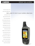
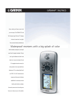
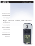
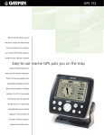
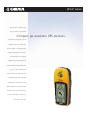
eTrex® series
With an eTrex® series GPS by your
side, you can take on the big wide
Compact, go-anywhere GPS receivers.
world without looking back. For basic
navigation, look to the original eTrex,
the low-cost GPS, or the Venture, which
accepts downloaded points of interest.
The Legend steps up the mapping
capabilities with its detailed basemap.
eTrex Summit is a basic GPS with built-in
electronic compass and barometric
altimeter while the Vista has all this plus
a detailed basemap. These smart little
handhelds are tough, waterproof and
WAAS-enabled for exceptional accuracy.
All feature simple, one-hand operations.
For your next adventure on land or sea,
pack light. Go with eTrex.
eTrex® series
compatible
Navigation features
Waypoints/icons:
Name and graphic symbol
Tracks:
Automatic track log; 10 saved tracks let
you retrace your path in both directions
Routes:
20 reversible
Trip computer:
Current speed, average speed, time of
sunrise/sunset, resetable maximum
speed, trip timer and trip distance
Map datums:
More than 100
Position format:
Lat/Lon, UTM/UPS, Maidenhead, MGRS,
Loran TDs (Venture, Legend and Vista
only) and other grids
GPS performance
Receiver:
12 parallel channel GPS receiver continuously tracks and uses up to 12 satellites
to compute and update your position
Acquisition times:
Warm:
Approximately 15 seconds
Cold:
Approximately 45 seconds
AutoLocate™:
Approximately 5 minutes
Update rate:
1/second, continuous
GPS accuracy:
Position:
< 15 meters, 95% typical*
Velocity:
0.05 meter/sec steady state
DGPS (WAAS) accuracy:
Position:
< 3 meters, 95% typical
Velocity:
0.05 meter/sec steady state
Dynamics:
6g’s
Interfaces:
RS232 with NMEA 0183, RTCM 104 DGPS
data format and proprietary GARMIN
Antenna:
Built-in patch
Power
Source:
Physical
Size:
Weight:
Display:
Case:
Temperature range:
User data storage:
Barometric altimeter feature (eTrex Summit and Vista only)
Accuracy:
10 feet with proper calibration
(user and/or automatic calibration)
Resolution:
1 foot
Range:
–2,000 to 30,000 feet
Elevation computer: Current elevation, resetable minimum
and maximum elevation, ascent/descent
rate, total ascent/descent, average and
maximum ascent/descent rate
Pressure:
Local pressure (mbar/inches HG), 12-hour
automatic pressure trend recording
Optional:
2 “AA” batteries (not included)
PC interface cable
(Venture, Legend and Vista only)
User’s guide
Quick reference guide
Wrist strap
Carrying case
Holster
PC interface cable
PC interface cable with 12-volt adapter
12-volt adapter cable
Handlebar mount
Marine mount
Automotive suction mount
Adjustable automotive mounting bracket
MapSource CD-ROMs
Instructional video
Here’s how the units are different
eTrex
eTrex Venture
eTrex Legend
eTrex Venture
Mark waypoint page
Map page
eTrex Summit
eTrex Legend
4.4"H x 2.0"W x 1.2"D (11.2 x 5.1 x 3.0 cm)
5.3 ounces (150 g) with batteries
2.1"H x 1.1"W (5.4 x 2.7 cm) high-contrast
LCD with bright backlighting
Waterproof to IEC 60529 IPX7 standards
5ºF to 158ºF (-15ºC to 70ºC)
Indefinite, no memory battery required
Electronic compass feature (eTrex Summit and Vista only)
Accuracy:
±2 degrees with proper calibration
(typical); ±5 degrees extreme northern
and southern latitudes
Resolution:
1 degree
Accessories
Standard:
eTrex
eTrex Summit
eTrex Vista
Compass page
Map page
(shown with optional MapSource
Fishing Hot Spots® detail)
eTrex Vista
Elevation page
eTrex Vista
Map page
(shown with optional
MapSource Topo detail)
©2005 Garmin Ltd. or its subsidiaries
Garmin International, Inc.
1200 East 151st Street
Olathe, Kansas 66062, U.S.A.
913/397.8200 fax 913/397.8282
Garmin (Europe) Ltd.
Unit 5, The Quadrangle
Abbey Park Industrial Estate
Romsey, SO51 9DL, U.K.
44/1794.519944 fax 44/1794.519222
Waypoints
WAAS enabled
database or map
display resolution
battery life
sensors
MapSource®
compatibility
REV0105
500
yes
none
64 x 128 pixels
22 hours
none
limited — able to
transfer waypoints,
routes and tracks
between PC and GPS
500
yes
city point database
160 x 288 pixels
20 hours
none
some — accepts
1 MB data from the
Points of Interest CD**
1,000
yes
detailed basemap
160 x 288 pixels
18 hours
none
extensive — accepts
8 MB of downloaded
map detail from a variety
of MapSource™ CDs**
500
yes
none
64 x 128 pixels
16 hours
electronic compass,
barometric altimeter
limited — able to
transfer waypoints,
routes and tracks
between PC and GPS
1,000
yes
detailed basemap
160 x 288 pixels
12 hours
electronic compass,
barometric altimeter
extensive — accepts
24 MB of downloaded
map detail from a variety
of MapSource™ CDs**
M01-20000-01
Garmin Corporation
No. 68, Jangshu 2nd Rd.
Shijr, Taipei County, Taiwan
886/2.2642.9199 fax 886/2.2642.9099
www.garmin.com
Specifications are preliminary and subject to change
without notice.
* Subject to accuracy degradation to 100m
2DRMS under the U.S. Department of Defense
imposed Selective Availability Program.
** These units are also able to transfer waypoints,
routes and tracks between the PC and GPS
using MapSource.™