1
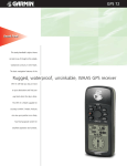
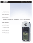
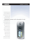
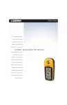
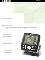
GPS 152
With the GPS 152 onboard, you can
head out for a day on the water knowing
that you will easily find your way back.
The 12-channel GPS is WAAS capable for
incredible accuracy. It features a horizontal
Easy-to-use marine GPS puts you on the map
display and simple keypad layout,
leaving you with maximum viewing area.
Thanks to its four-level grayscale screen
with adjustable backlighting, you’ll be
able to view your position in all lighting
conditions. The GPS 152 comes loaded
with American cities and navaids and
tide data for the U.S. It even accepts
downloaded data from the optional
MapSource™ Points of Interest CD
for listings of marinas, restaurants,
campgrounds and other services.
GPS 152
GPS 152 specifications
Navigation features
Waypoints/icons:
Routes:
Power
500 with name and graphic symbol,
10 nearest (automatic), 10 proximity
20 reversible routes with up to 30 points
each, plus MOB and TracBack® modes
Source:
10–40 VDC
Usage:
5 watts maximum at 10 VDC
Physical
Big numbers display clearly shows
your position.
Tracks:
Automatic track log; 10 saved tracks let
you retrace your path in both directions
Size:
5.0"W x 4.9"H x 2.5"D
(13.4 x 12.5 x 6.1 cm)
Trip computer:
Trip odometer, stopped time, moving
average, moving time, total average,
total time, maximum speed, odometer
Weight:
Less than 1 pound (454 g)
Display:
4.0" diagonal (10.2 cm) 160 x 100 pixels,
FSTN with adjustable backlighting
Alarms:
Anchor drag, arrival, off-course,
proximity waypoint and clock
Case:
Fully gasketed, high impact plastic alloy,
waterproof to IEC 529 IPX7 standards
Tables:
Built-in celestial tables for sun
and moon by date and position
Temperature range:
5ºF to 158ºF (-15ºC to 70ºC)
User data storage:
Indefinite, no memory battery required
Internal memory:
1 megabyte, for downloading maps
and points of interest
Tides:
Tide data (U.S.A. only)
Map datums:
More than 100 plus user datum
Position format:
Lat/Lon, UTM/UPS, Maidenhead,
MGRS, Loran TDs and other grids
GPS performance
Receiver:
WAAS enabled, 12 parallel channel GPS
receiver continuously tracks and uses up
to 12 satellites to compute and update
your position
Acquisition times:
Warm:
Cold:
AutoLocate™:
Approximately 15 seconds
Approximately 45 seconds
Approximately 5 minutes
Update rate:
1/second, continuous
GPS accuracy:
Position:
Velocity:
< 15 meters, 95% typical*
0.05 meter/sec steady state
The GPS 152 comes with tide data
for the U.S.A.
Accessories
Standard:
Power/data cable
Owner’s manual
Mounting bracket
Quick reference guide
GPS antenna
Optional:
AC/PC adapter, 7-pin
PC interface cable
12-volt adapter cable
MapSource™ Points of Interest CD-ROM
GBR 23 beacon receiver
DGPS (USCG) accuracy:
(Requires the purchase of optional beacon receiver)
Position:
3-5 meters, 95% typical*
Velocity:
0.05 meter/sec steady state
The pointer page provides graphic steering
guidance and other information.
©2001 GARMIN Corporation
DGPS (WAAS) accuracy:
Position:
< 3 meters, 95% typical*
Velocity:
0.05 meter/sec steady state
Dynamics:
6 g’s
Interfaces:
NMEA 0183 (2 inputs), RTCM 104 DGPS
and proprietary GARMIN
Antenna:
Internal QuadHelix; GPS 152 external
(GA29 remote marine mount
with 30 ft. cable)
Differential:
WAAS enabled USCG, RTCM-104
(Requires the purchase of
optional beacon receiver)
GARMIN International
1200 East 151st Street
Olathe, Kansas 66062, U.S.A.
913/397.8200 fax 913/397.8282
GARMIN (Europe) Ltd.
Unit 5, The Quadrangle
Abbey Park Industrial Estate
Romsey, SO51 9AQ, U.K.
44/1794.519944 fax 44/1794.519222
GARMIN (Asia) Corporation
No. 68, Jangshu 2nd Rd.
Shijr, Taipei County, Taiwan
886/2.2642.9199 fax 886/2.2642.9099
www.garmin.com
Specifications are preliminary and subject to change
without notice.
REV1101
M01-10107-00
* Subject to accuracy degradation to 100m
2DRMS under the U.S. Department of Defense
imposed Selective Availability Program.