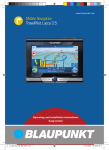
1
www.blaupunkt.com
Mobile Navigation
TravelPilot 700
Operating and installation instructions
(Long version)
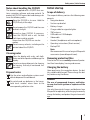
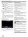
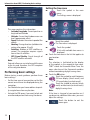
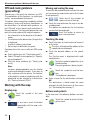
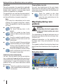
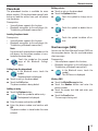
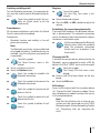
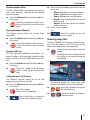
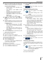
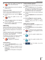
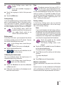
Device overview
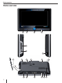
Device overview
2
1
3
4
6
7
5
8
9
10
19
2
18
11
12
17
16
13
15
14
Device overview
1 Display (touchscreen):
Simple and intuitive operation by touching
the buttons on the display.
2 VOL -:
Decreases the volume
3 On/Off switch:
• Long press (for longer than 1 second):
Switches the device on
• Long press (for longer than 3 seconds):
Switches the device off
• Short press: Calls up the main menu
4 VOL +:
Increases the volume
5 Socket for additional external TMC antenna
(internal TMC antenna is present)
6 Memory card slot
7 Socket for power supply (battery charger or
charger cable for the cigarette lighter)
8 Stylus for operation on the display
9 Digital camera, among other things for recognising signs
: Light sensor for automatic display brightness
(top side)
; Socket for additional external GPS antenna
(internal GPS antenna is present)
< Battery compartment cover
= DVB-T antenna (extendable)
> Socket for additional external DVB-T antenna
? Microphone for speech input and hands-free
system (Bluetooth)
@ Socket for headphones
A Serial port for connecting to the vehicle electronics (Smart Cable) or sound docking station
(Contact your Blaupunkt specialised dealer or
read the information via the Blaupunkt Internet pages at www.blaupunkt.com)
B USB port for data transfer
C AV-IN/OUT socket for back-up camera and
other audio/video devices
3
Contents
Device overview ..................................2
Safety notes ........................................8
Warning symbols used ...........................8
Use as directed .....................................8
Road safety ..........................................8
General safety notes ..............................8
Notes about handling the CD/DVD ...........9
Cleaning notes ......................................9
Disposal notes ......................................9
Initial startup ......................................9
Scope of delivery ..................................9
Removing protective films.......................9
Charging the battery ..............................9
Switching on the device........................10
Setting the language ............................10
Selecting a dataset ..............................10
Installation in the vehicle ...................10
Installation example .............................11
Attaching the suction cup holder ...........11
Attaching the mounting cup ..................11
Inserting the device in the mounting cup ..11
Removing the device ............................11
Removing the suction cup holder ...........11
Audio playback via the loudspeakers
in the vehicle (AUDIO-MIX function)....11
Switching on/off ................................12
Switch-on ..........................................12
Switching off ......................................12
Reset .................................................12
Operating the menus .........................12
Main menu .........................................12
Buttons..............................................12
Keyboard ...........................................12
Intelligent auto-completion function ....13
Buttons overview .............................13
Error-tolerant entry ..........................13
Lists ..................................................13
Information about GPS .......................13
GPS mode of operation ........................13
Displaying GPS info .............................13
4
Performing basic settings ..................14
Setting the time zone ...........................14
Entering the home address ...................15
Activating the PIN query .......................15
Configuring the PIN query..................15
Locking/unlocking the device .............15
Changing the PIN .............................15
Navigation ........................................16
Destination input ...............................16
Entering a country ...............................16
Entering an address ............................17
Entering coordinates ...........................17
Using the home address as destination ...17
Copying a destination from the map ......17
Speech input .....................................18
Points of interest (POI) ......................18
Special POIs .......................................19
My POIs ..........................................19
Supraregional POIs...........................19
Starting the POI entry ..........................19
Selecting a POI position .......................19
Selecting a POI....................................19
Calling a POI .......................................19
Tour planning ....................................20
Starting the tour planning .....................20
Loading the tour from the memory card ..20
Entering the tour .................................20
Editing a tour ......................................20
Start for this point first .........................21
Calculate to this point first ....................21
Exiting the tour planning .......................21
Using a destination from the
destination/tour memory ...................21
Additional functions after the
destination input/tour planning ..........22
Country info ......................................22
Simulation.........................................22
Starting the simulation .........................22
Simulation settings ..............................23
Contents
Storing the position ...........................23
Speech input ...................................31
Day/night view .................................31
Speed limit......................................32
Continuing a tour automatically ..........32
Showing/hiding tour info ...................32
Destination/tour memory ...................23
Saving destinations .............................23
Saving a destination or tour ...............23
Saving the last destination or tour .......24
Editing destinations .............................24
Delete all destinations ..........................24
Backing up destinations (backup copy) ....25
Exporting destinations ......................25
Importing destinations ......................25
Map display during route guidance......32
Navigation tools ..................................32
Route information ...............................33
POI note.............................................33
Speed limit (signpost recognition) .........33
Calculating a route .............................25
Starting the route calculation ................25
Video display during route guidance
(True Navigation)...............................33
Specifying route options ....................26
Voice output during route guidance.....34
Route guidance..................................27
Start route guidance ............................27
Destination input during route guidance..27
Reaching the place of destination ..........27
Quitting the route guidance ...................27
Disturbed GPS reception ......................27
Additional functions during route
guidance ...........................................34
Display information about the destination.. 34
Cancelling route guidance.....................34
Skipping the next destination ................34
Displaying the route list and entering
blockings ...........................................35
Showing/hiding route segments .........35
Traffic obstructions in the route list .....35
Blocking route segments ...................35
Unblocking ......................................35
Calculating an alternate route ................35
Entering a blocking ..............................35
Entering a blocking ...........................35
Unblocking ......................................35
Offroad route guidance (geocaching) ...28
Working with the map ........................28
Display map .......................................28
Moving and scaling the map ..................28
Touching the map ................................28
Buttons and symbols ...........................28
Map/navigation settings .......................29
Displaying the arrival/remaining
driving time .....................................29
Switching auto zoom on/off ...............29
Selecting a dataset ...........................29
Selecting units .................................30
Showing/hiding speed and altitude .....30
Aligning the camera ..........................30
Selecting the map/video display .........30
Showing/hiding points of interest
at motorways ...................................30
Showing/hiding destinations on
the map and activating/deactivating
POI notes ........................................30
Voice instructions.............................31
TMC function.....................................36
Establishing TMC reception ..................36
Traffic obstructions on the map display...36
Showing traffic reports ........................36
Switch on automatic traffic jam detours ..36
TMC settings ......................................36
Infotainment .....................................37
Bluetooth function (telephone)...........37
Starting the Bluetooth application..........38
Hands-free function .............................38
Calling ............................................38
5
Contents
Answering or rejecting a call ..............38
Ending a call and additional functions ...38
Managing the call list ........................38
Phone book ........................................39
Loading the phone book ....................39
Calling from the phone book ..............39
Adding an entry ...............................39
Editing entries .................................39
Short messages (SMS).........................39
Writing SMS ....................................39
Inbox/outbox ...................................40
Audio transmission ..............................40
File transfer ........................................40
Uploading/downloading data .............40
Establishing a Bluetooth connection .......41
Registering with the cell phone ...........41
Registering with the navigation device ..41
Establishing and disconnecting
Bluetooth connection........................41
Registering additional cell phones
with the navigation device .................42
Performing Bluetooth settings ...............42
Activating/deactivating the Bluetooth
function ..........................................42
Switching visibility on/off ..................43
Paired devices .................................43
Ringtone .........................................43
Establishing the connection
automatically ...................................43
Changing the PIN .............................43
RAS settings ....................................43
Automatic call answering ...................44
Illustrated phrase book ......................44
Camera function ...............................44
Taking pictures (geotagging) .................45
Filming ..............................................45
Entertainment ..................................45
Inserting and removing the memory card... 45
Starting Entertainment ........................46
Playing music files ..............................46
6
Equaliser ........................................46
Random playback (Mix).....................47
Repeated playback (Repeat) ..............47
Displaying ID3 tags ...........................47
Calling the music list (Browse) ...........47
Showing image files ............................47
Slide show ......................................48
Displaying path of file name ...............48
Rotating an image.............................48
Calling the image list (Browse) ...........48
Playing video files ................................48
Connecting the back-up camera or an
external audio/video source ..................49
Using the navigation device as video
source ............................................49
Using the external device as video
source ............................................49
Games ...............................................49
Television (DVB-T) .............................50
Establishing reception .........................50
Starting the DVB-T application...............50
Searching for stations ..........................50
Selecting a station ...............................50
Creating a favourites list .......................51
Teletext ..............................................51
Electronic programme guide (EPG) ........52
DVB-T settings ....................................52
Audio .............................................52
Video .............................................52
Subtitle ..........................................53
System ...........................................53
Internet function ...............................54
Configuring the Internet (WLAN settings) .. 54
Connecting to a visible WLAN network ... 54
Manually configuring and connecting
an invisible WLAN network (SSID is
suppressed) ....................................55
Disconnecting from a WLAN network....55
Web browser ......................................55
The toolbar......................................55
Contents
Calling up a web page .......................55
Selecting web pages/addresses from
history............................................56
Adding and selecting a bookmark .......56
Searching text on the current web page.. 57
Basic settings of the web browser .......57
Exit the web browser ........................58
e-mail communication ..........................58
Configuring e-mail communication ......58
Configuring and managing e-mail
accounts .........................................58
Settings for sending and receiving ......59
Performing spam settings ..................59
Additional settings ...........................60
Using the e-mail function ...................60
Editing an e-mail ..............................61
Internet telephony (VoIP) .....................61
Configuring VoIP ..............................61
Using VoIP.......................................62
Internet radio......................................62
Listening to Internet radio..................62
Adding stations to favourites and
deleting them from favourites.............62
Saving a new station .........................63
Podcasting .........................................63
Loading podcasts .............................63
Loading and playing episodes ............63
Editing podcasts/episodes ................63
Office function ..................................64
Starting the Office application ...............64
Displaying documents (viewer) .............64
Notes ................................................64
Writing programme (Notepad) ...........64
Drawing programme (Paint)...............65
Calendar ............................................65
Calculator ..........................................65
Voice recorder ....................................65
Playing recordings ............................66
Editing recordings ............................66
Blocking recordings ..........................66
File manager .......................................66
My files .............................................67
My files in the internal memory ..............67
Playing or displaying My files .................67
Transferring My files ............................67
Data transfer with memory card ............68
Loading data onto the memory card ....68
Loading data from the memory card
to the memory .................................68
Data transfer with computer (USB) ........68
Copying data from the navigation
device ............................................68
Copying data to the navigation
device ............................................68
Settings ............................................69
Setting the alarm..............................69
Audio/video ....................................69
Setting My Button in the main menu
(quick access) .................................69
Demo mode ....................................70
Theft protection ...............................70
Display ...........................................70
Product information .........................70
Sound & volume ...............................70
Language ........................................70
Saving energy ..................................71
Button sound ...................................71
Calibrating the touchscreen ...............71
Time...............................................71
Factory settings ...............................71
Wireless connections ........................71
Software ...........................................72
Reinstalling navigation software ............72
Updating the navigation software...........72
Service .............................................72
Warranty...........................................72
Technical data ...................................73
Troubleshooting table ........................74
7
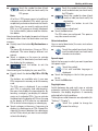
Safety notes
Safety notes
General safety notes
For your personal benefit, carefully read the following safety notes before operating the device
for the first time.
Observe the following notes to protect the device
against defects and yourself against injuries and
life-threatening dangers from an ignition or explosion:
• Protect the device against moisture since it
is not waterproof and not splashproof.
• Do not modify or open the device. Otherwise, it could be damaged and then ignite or
explode. Or acidic, flammable liquid could
run out of the battery.
• Do not expose the device to very low (below
-20 °C) and very high temperatures (above
60 °C), e.g. close to fire, heating devices or in
a parked car with direct exposure to the sun.
Moisture could form inside the device or the
device could overheat. The device or battery
could deform and even ignite or explode. Or
acidic, flammable liquid could run out of the
battery.
• If battery liquid comes into contact with
your eyes or skin, immediately flush with water and consult a doctor.
• Always ensure a safe installation in the vehicle. If the bracket is not correctly affixed,
the device may turn into a safety risk for the
vehicle occupants during heavy braking or in
case of an impact.
• Remove the device from the power supply
when you park your vehicle since it continues to use battery power and could deplete
the vehicle battery. Do not unplug the connector of the power supply by pulling on the
wire. The wire could be damaged and cause
electrical shock.
Warning symbols used
In the chapters, warning symbols refer to important notes for you and the device.
DANGER!
Warns about injuries or life-threatening
danger
DANGER!
Warns about accidents
Use as directed
The device is designed for mobile use in vehicles.
Some functions may not be used by the driver.
Special information about the navigation of trucks,
busses and campers, such as altitude and width
limitations or maximum permissible road load, is
not included in the navigation data!
Navigation off the roads (offroad route guidance)
is not possible with this navigation device.
Road safety
The navigation device does not release
you from your responsibility as a driver
for correct and prudent behaviour in traffic. Always observe the applicable traffic
rules.
Use your device in such a way that you
can always safely control your vehicle. If
in doubt, stop and operate the device
while the vehicle is standing. If you are
the driver, you may not use the applications that distract you from the traffic
around you (depending on the scope of
functions of the device, e.g. watching TV,
videos).
8
Safety notes | Initial startup
Notes about handling the CD/DVD
The device is supplied with a CD/DVD that contains navigation software and map material. To
protect the CD/DVD against dirt and damage, observe the following notes:
Store the CD/DVD in its case. Hold the
CD/DVD only at the edge.
Do not expose the CD/DVD and the case
to direct sunlight.
Use only a clean CD/DVD. If necessary,
clean the CD/DVD with a soft, lint-free
cloth from inside to outside.
Never clean the CD/DVD in a circular
motion.
Do not use any solvents, including on the
printed side of the CD/DVD.
Cleaning notes
Clean the display with a dry, soft cloth.
Water and other liquids could damage the
display.
Do not use strong detergents for cleaning
the housing. Use only a moistened, lintfree cloth.
Disposal notes
Use the return and collection systems available to dispose of the old device.
Initial startup
Scope of delivery
The scope of delivery contains the following components:
• Navigation device
• Suction cup bracket
• Battery charger
• Charger cable for cigarette lighter
• TMC antenna
• USB cable incl. USB adapter
• Video cable
• Headset (headphones with microphone)
• Operating instructions (Short version)
• Backup DVD
Note:
We recommend the use of original Blaupunkt
accessories (www.blaupunkt.com).
Removing protective films
Prior to the first use, carefully remove all protective films from display, housing and camera.
Charging the battery
Upon purchasing the navigation device, the battery could be discharged. Please charge the battery before using the device.
DANGER!
Do not discard any batteries in the household trash; instead, return them to the
corresponding collection sites.
The use of unapproved chargers and batteries may lead to an ignition or explosion of the
device
Use only the original chargers and batteries from
Blaupunkt for operating and charging to correctly
charge the battery and protect it against overvoltage.
9
Initial startup | Installation in the vehicle
The charging process in the switched-off state is
approx. 3 hours. The charge state indicator is located on the top display bar.
The device is supplied by an external
•
power source.
The device is supplied by its internal
•
battery. The charge state of the battery is sufficient.
The device is supplied by its internal
•
battery. The charge state of the battery is low.
If the charge state of the battery becomes weak,
the navigation device warns you about it.
쏅 Connect the battery charger or the charger
cable for the cigarette lighter to the charging
socket.
Note:
The battery is equipped with a protection
against overheating from excessive current
flow. The protection prevents charging the
battery starting at an ambient temperature
above 45 °C.
Switching on the device
Setting the language
The device uses English as standard language. If
you switch on the device for the first time, a dialogue menu is displayed in which you can select
another language for the menus and voice outputs
as well as for the speech input.
쏅 Select your preferred language in the dialogue menu.
쏅 Please follow the instructions.
The language is loaded and the main menu is
displayed.
Selecting a dataset
After the initial start of the navigation, you must
select a road map. The message "Data record not
available" is automatically displayed.
쏅 Touch the OK button.
A list of the available road maps is displayed.
쏅 Touch the desired road map in the list to select it.
Installation in the vehicle
For temporary installation in a vehicle, the navigation device features a holder to attach it to
the windshield.
A
DANGER!
쏅 Press and hold the On/Off switch for longer
than 1 second.
10
The installation at an unsuitable location can cause injuries
Install the navigation device so that it does not
block your view and does not distract from the
traffic.
Do not install the device in the airbag deployment
area.
Ensure that the device does not pose a threat to
passengers in the vehicle in case of emergency
braking.
Check the firm installation of the bracket at regular
intervals. The bracket can loosen due to changes
in the ambient temperature.
Installation in the vehicle | Audio playback via the loudspeakers
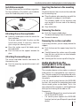
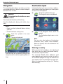
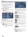
Installation example
The figure shows only an installation suggestion.
For the installation in the vehicle, you should observe the listed safety notes in any case.
ca. 15 cm
Inserting the device in the mounting
cup
The device features two cut-outs on the underside
for the mounting cup.
쏅 Place the device onto mounting cup with the
underside first and push it to the back.
The clamping holder of the mounting cup
must engage in the rear side of the housing
with a click.
쏅 Align the bracket.
Removing the device
Attaching the suction cup holder
쏅 Locate a suitable place inside the vehicle for
the installation.
To ensure a perfect hold, the glass must be
free of dust and oil. If necessary, clean the
glass using a lens cleaning tissue.
쏅 Press the suction cup of the holder against
the windshield.
쏅 Push the lever on the support towards the
glass.
Attaching the mounting cup
The suction cup holder features two mounts for
the mounting cup.
쏅 Push the mounting cup onto the mount until
it engages.
쏅 Push the clamping holder down.
The device disengages from the bracket.
쏅 Remove the device.
Removing the suction cup holder
If you change vehicles, you can simply remove the
support.
쏅 Push the lever on the support away from the
glass.
쏅 Carefully loosen the suction cup at the edge
from the glass so that air can enter between
suction cup and glass.
쏅 Carefully pull the suction cup off of the glass.
Audio playback via the
loudspeakers in the vehicle
(AUDIO-MIX function)
The navigation device can be used as an external
audio source if it is connected to a car sound system. The voice output of the navigation and music
tracks is then played back via the loudspeakers in
the vehicle.
If the car sound system features the AUDIO-MIX
function, the sound of the navigation device and
the car sound system can be mixed. That is, the
voice output of the navigation is switched through
while you are listening to the radio or a CD.
Prerequisite:
• Compatible Blaupunkt car sound system with
rear or front AUX-IN socket
• Car sound system supports the AUDIO-MIX
function (contact your Blaupunkt specialised
dealer)
11
Audio playback via the loudspeakers | Switching on/off | Operating the menus
쏅 Connect the car sound system with the navigation device by means of a cable – according
to the instructions of the car sound system.
쏅 On the car sound system, activate the
AUDIO-MIX function by switching on the AUXIN socket.
The voice output of the navigation and audio
source of the car sound system are mixed.
- or 쏅 On the car sound system, deactivate the
AUDIO-MIX function by switching off the AUXIN socket.
The navigation device is used as external
audio source.
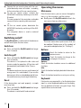
Operating the menus
Main menu
From the main menu, you can access the applications, e.g. the navigation, and the settings.
쏅 Briefly press the On/Off switch to reach the
main menu from any other menu.
Switching on/off
The On/Off switch is used to switch the device on
and off and to open the main menu.
Switch-on
쏅 Press and hold the On/Off switch for longer
than 1 second.
The main menu offers quick access that can
be modified. Replace one of the symbols of
your preferred application (ch. "Settings").
Buttons
Touch this button to return to the
previous menu.
Touch this button to change to the
next page in the menu.
Switching off
쏅 Press and hold the On/Off switch for longer
than 3 seconds.
The device is first placed in idle state and
remains ready for operation. All functions will
be completely switched off after 2 hours.
Note:
The device continues to use a small amount of
energy even if it is switched off. If you use the
device again after an extended period of time,
it may be necessary to recharge the battery.
Reset
If the device does not work properly, a simple
reset may help.
쏅 Press and hold the On/Off switch for longer
than 14 seconds.
The device is switched off and restarted.
12
Options:
Touch this button to obtain access to additional
functions.
Info:
Touch this button to display detailed information.
OK:
Touch this button to confirm an entry or a setting.
Keyboard
If text entries are required (e.g. for the destination
input), a virtual keyboard appears on the display.
You can perform all entries using your finger. Only
capital letters can be entered.
Operating the menus | Information about GPS
Intelligent auto-completion function
During destination input, the device auto-completes characters as far as possible and offers
only those characters on the keyboard that are
logically possible.
쏅 Touch an entry to select it.
쏅 Touch the OK button to accept the entry or to
confirm it.
쏅 Touch the Info button to display abbreviated
entries in their entirety.
Buttons overview
Information about GPS
Delete last character
Entering blank spaces
Call up alternate character keyboard (incl.
special characters, umlauts)
Call up numeric keypad, e.g. to enter the
house number
Call up character keyboard
Call up error-tolerant entry
Error-tolerant entry
The error-tolerant entry helps if you do not know
the exact spelling of a city. After your entry, a list
with city names spelled in a similar way appears.
Touch the symbol in the text entry.
쏅
The error-tolerant entry is displayed.
쏅 Enter a city name and touch OK.
A list with alternate city names is displayed.
Lists
You can frequently display lists form which you can
select an entry (e.g. a destination). For example, if
you do not enter the complete name of a location,
a list with possible results is displayed.
Touch the button to display the
쏅
list.
The number of entries is displayed next to the symbol.
Touch one of the buttons to
쏅
scroll through the list.
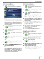
The GPS (Global Positioning System) allows
world-wide navigation and locating via satellites
to determine a position.
GPS mode of operation
The navigation device measures the current position of your vehicle via GPS and compares these
coordinates with its map material. The map material contains the geographic coordinates of points
of interest, streets and cities that you can view on
the display of the navigation device. The device
uses this information to calculate the route to the
destination you entered.
Displaying GPS info
Information about the GPS reception of the device, your current position and your speed can
be found in the GPS Info menu.
쏅
Touch the symbol in the main
menu.
The map is displayed.
쏅
Touch the symbol.
The Navigation menu is displayed.
쏅
쏅
Touch the button.
The display shows the second
page of the menu.
Touch the symbol.
The GPS Info menu is displayed.
13
Information about GPS | Performing basic settings
Setting the time zone
쏅
This menu contains this information:
– Latitude/Longitude: Current position in
longitude and latitude
– Altitude: Current height above mean sea
level (approximate value)
– Speed: Indicates the current speed of the
vehicle
– Heading: Driving direction (reliable information after approx. 5 km/h)
– Satellites: Number of GPS satellites received. The navigation requires signals
from at least 3 satellites.
– GPS Signal Quality: Signal strength of
the GPS satellites received.
Note:
External influences can interfere with the view
to the sky and, therefore, the GPS reception
of the navigation device.
Performing basic settings
Before starting a route guidance, perform these
basic settings:
• Set the time zone of your position so that the
correct arrival times are displayed during the
navigation.
• You should enter your home address to quickly navigate home from any location.
• Activate the PIN query if you want to lock out
unauthorised persons from using the device.
쏅
Touch the symbol.
The Time menu is displayed.
쏅
Touch the symbol.
A list with available time zones is
displayed.
Touch the time zone in the list that applies to
your location.
Note:
The selection is facilitated by the display
of the capitols in the respective time zone.
"GMT" stands for Greenwich Mean Time, the
mean solar time at the Greenwich meridian
without considering daylight savings time.
Touch the OK button.
Touch the symbol to switch between
24-hour display (check mark) and
12-hour display (no check mark).
Touch the symbol to activate (check
mark) or deactivate (no check mark)
daylight savings time.
Note:
If the time is changed at your position or if
you drive into a different time zone, you must
adjust the settings.
Touch the button to exit the
menu again.
쏅
쏅
쏅
쏅
쏅
14
Touch the symbol in the main
menu.
The Settings menu is displayed.
Performing basic settings
Entering the home address
쏅
쏅
쏅
쏅
쏅
Touch the symbol in the main
menu.
The map is displayed.
Touch the symbol.
The Navigation menu is displayed.
Touch the symbol.
The Destination Input menu is displayed.
Touch the symbol.
The Destination Input For Home
Address menu is displayed.
Touch the symbol to enter a new address as described in the chapter
"Destination input", "Entering an
address".
Note:
The configured home address can be viewed
at any time in the Destination Input For Home
Address menu and changed, if necessary
(Change button).
Activating the PIN query
The PIN query allows you to lock out unauthorised
persons from using the device. Hence, every time
you switch on the device, the PIN (Personal Identification Number) you configured for yourself is
requested. The PIN can be changed at any time.
If you should forget the PIN, you can unblock the
device again with the PUK (Personal Unblocking
Key) which you define yourself. The PUK cannot
be changed.
To secure your PUK:
쏅 Register on the Blaupunkt Internet page and
follow the instructions:
http://puk.blaupunkt.com
Note:
During the PIN entry, you have only 3 attempts
to enter the correct PIN or subsequently 3 attempts to enter the correct PUK. If you enter
an incorrect PUK for the 3rd time, your device
is permanently blocked and the device must
be returned to the Blaupunkt service.
Configuring the PIN query
Touch the symbol in the main
쏅
menu.
The Settings menu is displayed.
쏅
Touch the button to scroll
through this menu.
Touch the symbol.
쏅
The Anti-Theft Protection menu is
displayed.
쏅 Touch the Anti-theft Protection button.
쏅 Touch the OK button.
The PIN query is displayed.
쏅 Follow the instructions and enter a self-selected PIN.
쏅 Touch the OK button.
The initial configuration of the PIN is followed by a
request to enter a PUK. The PUK is used to unlock
the device if you should forget the PIN.
쏅 Follow the instructions and enter a self-selected PUK.
쏅 Touch the OK button.
Locking/unlocking the device
Prerequisite:
• You configured the PIN query.
쏅 In the Anti Theft Protection menu, touch the
Anti-Theft Protection button to lock the device (check mark) or to unlock it (no check
mark).
The PIN query is displayed.
쏅 Enter your PIN.
쏅 Touch the OK button.
Changing the PIN
쏅 In the Anti Theft Protection menu, touch the
Change PIN Code button.
The PIN query is displayed.
쏅 Follow the instructions and enter a new selfselected PIN.
쏅 Touch the OK button.
15
Navigation | Destination input
Navigation
Destination input
The navigation device does not release you from
your responsibility as a driver for correct and prudent behaviour in traffic.
In the destination input, you can enter an address,
select a destination from memory, or select a point
of interest via the keyboard.
Touch the symbol on the map.
쏅
The Navigation menu is displayed.
DANGER!
Distraction from the traffic can cause
accidents
Do not operate the device while driving.
View the display only during safe traffic situations.
Notes:
• Routes are best planned before starting
your trip.
• Perform the basic settings first.
Touch the symbol in the main
쏅
menu.
The map is displayed.
쏅
In the Navigation menu, touch the
symbol.
The Destination Input menu is displayed.
Note:
You can only select places of destination
(countries, cities, streets, house numbers,
points of interest) that are contained in the
map material.
Entering a country
From the map, you can directly change to the
navigation menu or to the map/navigation settings.
16
When you enter the first address, a list is displayed
from which you can select the desired country.
The countries are preinstalled.
The enclosed CD/DVD offers additional road
maps depending on the device variant as well as
an installation program to copy the countries to
your memory card. The road maps are made available in the map/navigation settings (ch. "Working
with the map").
Destination input
Entering an address
Entering coordinates
쏅
쏅
Touch the symbol.
The Destination menu is displayed.
쏅
쏅
Note:
You do not have to repeat entering the country,
city and street information every time. Only if
your destination is at a different location than
the previous one will you have to re-enter the
destination address.
Touch the symbol to select a differ쏅
ent country.
쏅
Touch the symbol and enter the city
or postal code.
쏅
Touch the symbol and enter the
street.
쏅
Touch the symbol and enter the
house number.
- or -
쏅
Touch the symbol and enter the
street that intersects the previously
entered street.
쏅 Touch the Start Route Guidance button to
start the route guidance.
Note:
After the destination input, you can start the
route guidance or store the destination. For
further details, read the chapter "Additional
functions after the destination input".
쏅
쏅
쏅
쏅
쏅
Touch the symbol.
The Destination Coordinates menu is
displayed.
Touch the symbol to enter the latitude.
The keyboard is displayed.
Touch the symbol to enter the longitude.
The keyboard is displayed.
The coordinates can be entered in decimal or
DMS format (Degrees, Minutes, Seconds).
Enter the coordinates in decimal format by
touching the number buttons, followed by the
comma buttons.
Enter the coordinates in DMS format by selecting the cardinal point first. To do so, touch
the N/S or E/W button.
Next, enter the coordinates with degrees (°)
and minutes (‘) via the keyboard.
Touch the OK button.
Touch the Start Route Guidance button.
Using the home address as
destination
쏅
Touch the symbol in the Navigation
menu.
The route guidance is being started.
Copying a destination from the map
쏅
Touch the symbol.
The map is displayed.
쏅 Move and scale the map as described in the
chapter "Working with the map".
쏅 Touch a location of your choice.
The city is selected and the address or the
coordinates are displayed. It is also possible to display several addresses.
17
Destination input | Speech input | Points of interest (POI)
쏅
쏅 Touch the desired address or the coordinates.
The Position menu is displayed with additional buttons.
Touch the symbol to start the route
쏅
guidance.
Speech input
Enter a destination without looking at the display. The speech input is possible for the following languages: German, English, Spanish, Italian,
French, Portuguese and Dutch (Changing the language: ch. "Working with the map", "Map/navigation settings").
쏅 In the Navigation or Destination Input menu,
touch the Speech Input button.
- or On the map, touch the symbol on the
쏅
bottom display bar.
Note:
The symbol is available only if no route guidance is active. During route guidance it is not
displayed.
The menu for the speech input is displayed
with the possible voice commands. The voice
output of the system asks you for speech input or provides help.
Notes:
• Ensure that no noises in your environment
interfere with the speech input, e.g. ventilation or open windows.
• The voice output of the system can be cancelled by touching the display.
18
As soon as the warning beep sounds
and the green light is lit, speak loudly
and clearly.
If your voice command is recognised, it may
be repeated for verification and displayed on
the bottom display bar. The corresponding
submenu is opened or the route guidance is
started.
The following speech inputs for the destination input are possible:
– "Start route guidance": Direct start of the
route guidance to the last destination.
– "Exit route guidance": Exit the current
route guidance.
– "Destination input": Entry of the destination address in several steps (country,
city, street, house number).
– "Navigate to ...": Selection of a destination by giving its name (only for previously named destinations).
– "Last destinations"/ "Saved destinations":
Selection of a destination from the last or
saved destinations.
– "Additional help": Additional voice commands for saving and naming destinations are displayed, read aloud and
explained.
The following speech inputs are possible in all
speech input menus:
– "Help": Voice commands of the current
menu are displayed, read aloud and
explained. Over time, you will become
familiar with the voice commands and
do no longer need any help.
– "Cancel": Exit speech input.
Points of interest (POI)
Points of interest (POI) are specific locations,
such as parking facilities and petrol stations, that
are stored in the map material. First, determine
the position for the POI (ch. "Selecting the POI
position"). Next, select the desired POI ("Selecting a POI").
You can also select a photo taken with the device
and, therefore, your position while taking the photo, as a point of interest.
Points of interest (POI)
Special POIs
My POIs
Besides point-of-interest (POI) categories, such as petrol stations and parking,
the My POIs category is available.
This expands the navigation with individual destinations, e.g. with the addresses of friends or your
favourite restaurant.
The enclosed CD/DVD contains an installation
programme with instructions to create your own
POI lists at computer or to load existing POI lists.
Supraregional POIs
Supraregional POIs are POIs that cannot be assigned to any city. This can be an airport, a motorway exit or a mountain pass.
쏅
쏅
쏅
Starting the POI entry
Prerequisite:
• You are in the Destination Input menu (ch.
"Destination input")
쏅
Touch the symbol in the Destination
Input menu.
The Points of Interest menu is displayed.
Selecting a POI position
쏅
쏅
쏅
In the Points Of Interest menu, touch
the symbol to enter a city. A different
country can be selected first.
- or In the Points Of Interest menu, touch
the symbol to select a POI nearby.
- or In the Points Of Interest menu, touch
the symbol to select a POI in the
destination area.
쏅
Note:
The destination to which you started a route
guidance last is taken as the destination
area.
- or In the Points Of Interest menu, touch
the symbol to select a POI close to
the home address.
- or In the Points Of Interest menu, touch
the symbol to select a location on
the map (ch. "Destination input",
"Copying a destination from the
map").
- or In the Points Of Interest menu, touch
the symbol to select a supraregional
POI.
- or In the Points Of Interest menu, touch the My
Pictures button to select an image and, therefore, the location of the photo as the destination .
Selecting a POI
쏅 Touch one of the symbols to select a point of
interest category.
For some points of interest, you can enter the
name via the keyboard or call up a list in which
you select the desired point of interest.
쏅 Touch the Start Route Guidance button.
Note:
After the destination input, you can start the
route guidance or store the destination (ch.
"Additional functions after the destination
input").
Calling a POI
If you selected the POI, the phone number is displayed, if available (e.g. for hospitals, hotels). You
can dial the point of interest before you start the
route guidance.
19
Points of interest (POI) | Tour planning
Prerequisite:
• Bluetooth connection to the cell phone (ch.
"Bluetooth function")
쏅 After selecting the POI, touch the Options
button to call up the add-on menu.
Touch the symbol.
쏅
The message "Outgoing Call" and the
phone number are displayed. The
point of interest is being dialed.
Tour planning
The tour planning is used to enter a tour with a
random starting point and several interim destinations.
Perform the tour planning on the device itself or
create a tour on the computer and upload it to the
device from a memory card.
Starting the tour planning
Prerequisite:
• You are in the Destination Input menu (ch.
"Destination input")
Touch the symbol in the Destination
쏅
Input menu.
The Tour Planning menu is displayed.
Note:
If the tour on the memory card has more than
10 destinations, only the first 10 destinations
are loaded and displayed.
Entering the tour
쏅 In the Tour Planning menu, touch the Add
Destination/Tour button.
쏅 Enter a destination as described in the chapter "Destination input".
Note:
Previously saved tours can be loaded from
the Destination & Tour Memory and additional
destinations can be added.
쏅 Touch the OK button.
쏅 Repeat the steps to enter additional destinations.
Note:
You can enter a tour with up to 10 destinations.
Editing a tour
쏅 In the Tour Planning menu, touch the destination to be edited.
The destination is displayed with its address
in the tour list.
Loading the tour from the memory
card
Use tours with up to 10 interim destinations from
the memory card. The enclosed CD/DVD contains
an installation programme with instructions for
the tour planning with the computer.
쏅 Insert the memory card in the device as
described in the ch. "Entertainment".
쏅 In the Tour Planning menu, touch the Load
Tour from SD button.
The tours on the memory card are listed.
쏅 Touch an entry in the list to load the desired
tour.
The Tour Planning menu is displayed. The
interim destinations of the tour are listed.
20
쏅
쏅
쏅
쏅
Note:
For the extended view for long destination addresses, touch the desired destination twice
in the tour list.
Touch the symbol to move the destination up.
Touch the symbol to move the destination down.
Touch the symbol to delete the destination.
Touch the symbol to display the destination on the map.
Tour planning | Using a destination from the destination memory
쏅
Touch the button to close the
map view.
Touch the buttons to select an쏅
other destination in the tour
list.
The destination can be edited in
the same way.
If you performed changes to the settings:
Touch the button to exit the
쏅
menu.
Start for this point first
Start the route guidance from an interim destination, e.g. to continue the tour after a break.
쏅 In the Tour Planning menu, touch the destination from which the route guidance should
start.
The destination is displayed with its address
in the tour list.
쏅 Touch the Options button to call up the addon menu.
Touch the symbol.
쏅
The route is calculated starting with
the current position and the route
guidance starts to the next interim
destination (ch. "Route guidance").
Calculate to this point first
Calculate the route from a specific interim destination to learn about distance and driving time:
쏅 In the Tour Planning menu, touch the destination from which the route calculation should
start.
The destination is displayed with its address
in the tour list.
쏅 Touch the Options button to call up the addon menu.
Touch the symbol.
쏅
The route is calculated based on the
current position (ch. "Calculating a
route").
Exiting the tour planning
쏅
Touch this button to exit the
menu.
쏅 Save the tour in My destinations & tours or
delete it.
Using a destination from the
destination/tour memory
The last and preferred destinations or tours are
stored in the destination & tour memory (ch. "Destination/tour memory").
In the Navigation menu, touch the
쏅
symbol.
The Destination & Tour Memory
menu is displayed.
Touch the symbol.
쏅
The My Destinations & Tours menu is
displayed.
- or Touch the symbol.
쏅
The Last Destinations & Tours menu
is displayed.
쏅 Touch the desired destination.
쏅 Touch the Info button to display the address
of the destination.
쏅 Touch the Show in Map button to display the
address of the destination.
Touch the button twice to return
쏅
to the destination & tour memory.
쏅 Touch the Start Route Guidance button.
21
Additional functions after the destination input | Country info | Simulation
Additional functions after the
destination input/tour planning
Prerequisite:
• Destination input via keyboard or speech input
- or • Selection of a point of interest
- or • You entered or loaded a tour
쏅 Touch the Options button to call up the addon menu.
You have now the following options:
Defining route options (ch.
–
"Specifying route options")
–
Calculating a route (ch.
"Calculating a route")
–
Saving a destination or
tour (ch. "Destination/
tour memory")
Displaying a destination or tour on the
map (ch. "Working
with the map")
For certain points of interest only
(e.g. hospital, hotel): Dialling a
destination (ch. "Selecting a
POI")
For tour planning only:
Load tour from memory card (if
you already entered destinations, the tour is being added)
–
–
–
Country info
For the country in which you are currently located,
general traffic rules are provided, e.g. the maximum speed.
During route guidance, the country information
is displayed on the map as soon as you cross a
national border.
22
DANGER!
Disregarding the local traffic rules and
street routing can cause accidents
The country information may not be current due
to short-term changes in the law, signposts or
similar.
The traffic rules and local street routing always
have priority over the information of the navigation device.
쏅
쏅
In the Navigation menu, touch
the button to display the second
page of the menu.
In the Navigation menu, touch the
symbol.
The country info is displayed.
Simulation
Start the route simulation to learn the functions
during route guidance.
Starting the simulation
Enter any start position and the destination of the
simulation. If you want to simulate a tour with interim destinations, select a saved tour for the destination (ch. "Tour planning").
Touch the symbol in the Navigation
쏅
menu.
The Simulation menu is displayed.
쏅 Touch the upper field and enter the start position.
쏅 Touch the lower field and enter the destination.
Enter the start position and the destination
for the simulation as it is done in the destination input.
쏅 Touch the Start Simulation button to travel
the route.
Simulation | Storing the position | Destination/tour memory
Simulation settings
You can specify whether the route should be travelled once or endlessly during the simulation.
쏅 Touch the Options button to call up the addon menu.
Touch the symbol to change between
쏅
single and endless simulation.
in the symbol
The endless loop
indicates that the endless simulation
is activated.
Storing the position
Store your current position as destination and
start a route guidance to it at a later time.
In the Navigation menu, touch
쏅
the button to display the second
page of the menu.
Touch the symbol.
쏅
The Position Information menu is
displayed.
쏅 Enter a name for the destination and confirm
with OK.
The destination is stored under the name entered in the My Destinations & Tours menu.
Destination/tour memory
Two lists are available in which destinations or
tours are saved:
• My Destinations & Tours:
Frequent destinations or tours can be stored
permanently in the My Destinations & Tours
menu (max. approx. 100). The destination
receives a name of your choice.
• Last Destinations & Tours:
The last 20 destinations and tours, for which a
route was calculated or a route guidance was
started (ch. "Calculating a route" or "Route
guidance"), are listed in the Last Destinations
menu.
Saving destinations
Permanently store a destination or tour after its
entry or from the memory in My Destinations &
Tours.
This menu contains this information:
– Latitude/Longitude: Current position in
longitude and latitude
– Altitude: Current height above mean sea
level
– The address of the current location, if it is
contained in the map material
– The compass: Direction North (reliable
information after approx. 5 km/h)
쏅 Touch the Save As Destination button.
The keyboard is displayed.
Saving a destination or tour
Prerequisite:
• You entered a destination as described in the
chapter "Destination input".
- or • You entered a point of interest as described in
the chapter "Points of interest".
- or • You planned a tour as described in the chapter "Tour planning".
쏅 In the Destination menu, touch the Options
button to call up the add-on menu.
쏅
Touch the symbol.
The keyboard is displayed.
23
Destination/tour memory
쏅 Enter a name for the destination and touch
OK.
The destination is stored under the name entered in the My Destinations & Tours menu.
Saving the last destination or tour
In the Navigation menu, touch the
쏅
symbol.
The Destination & Tour Memory
menu is displayed.
Touch the symbol.
쏅
The Administrate menu is displayed.
쏅
Touch the symbol to edit the last destinations.
쏅 Select the destination to be saved in the Last
destinations list.
Touch the symbol.
쏅
The keyboard is displayed.
쏅 Enter a name for the destination and touch
OK.
The destination is stored under the name entered in the My Destinations & Tours menu.
Editing destinations
Saved destinations can be renamed, the order can
be changed or deleted. Last destinations can be
deleted.
Touch the symbol in the Navigation
쏅
menu.
The Destination Memory menu is
displayed.
Touch the symbol.
쏅
The Administrate menu is displayed.
쏅
Touch the symbol to edit the last destinations and tours.
- or -
쏅
24
Touch the symbol to edit the stored
destinations and tours.
In both cases, the list with destinations and tours is displayed.
쏅 Touch the destination in the list to edit it.
쏅
Touch one of the symbols to
move the destination up or
down.
쏅
Touch the symbol to delete the destination.
쏅
Touch the symbol to rename the destination.
The keyboard is displayed.
쏅 Enter a new name for the destination and
touch OK.
The destination is stored under the name entered in the My Destinations & Tours menu.
Delete all destinations
You can delete all the last destinations or all stored
destinations:
쏅
In the Navigation menu, touch the
symbol.
The Destination & Tour Memory
menu is displayed.
쏅
Touch the symbol.
The Administrate menu is displayed.
쏅
Touch the symbol to delete all the last
destinations.
- or -
쏅
Touch the symbol to delete all stored
destinations.
A confirmation is displayed.
쏅 Touch Yes to delete the destinations.
- or 쏅 Touch No to cancel the procedure.
Destination/tour memory | Calculating a route
Backing up destinations
(backup copy)
To back up the saved destinations (My Destinations & Tours) and the home address, back the
destinations up to a memory card.
쏅 Insert the memory card in the device as described in the chapter "Entertainment".
In the Navigation menu, touch the
쏅
symbol.
The Destination & Tour Memory
menu is displayed.
Touch the symbol.
쏅
The Administrate menu is displayed.
Exporting destinations
Touch the symbol.
쏅
The destinations and home address
are copied to the memory card.
Importing destinations
Touch the symbol.
쏅
The Import from SD menu is displayed.
The destinations in the device are not overwritten. My destinations & tours are added,
the same names may occur multiple times.
The home address is loaded only if none
exists in the device.
Starting the route calculation
Conveniently plan your vacation trip at home and
gain an overview of the route and driving time –
even without GPS reception.
Prerequisite:
• You entered a destination as described in the
chapter "Destination input".
- or • You entered a point of interest as described
in the chapter "Points of interest".
- or • You planned a tour as described in the chapter "Tour planning".
쏅 Touch the Options button to call up the addon menu.
Touch the symbol.
쏅
The route is being calculated.
- or 쏅
쏅
Calculating a route
Calculate the route to a destination entered to
learn about distance and driving time: Afterwards, you have the option of starting the route
guidance or further optimising the route options
(ch. "Specifying route options").
All destinations, for which a route is calculated,
are stored in the Last Destinations & Tours.
쏅
쏅
쏅
쏅
For tours, touch the symbol.
The Set Tour Start Point menu is displayed.
Select the current position as starting point
or enter an address.
The destination with information about time
and distance is displayed. The interim destinations are displayed for tours.
Note:
If no GPS reception is available, the last
known position is taken as the starting point
of the route.
Touch a destination to display more information about time and distance.
Touch this button to exit the
menu.
Touch the Info button to display the route on
the map next or to calculate alternative routes
by distance and driving time (calculating an
alternate route, ch. "Additional functions during route guidance").
Touch the Start Route Guidance button to
start the route guidance.
25
Calculating a route | Specifying route options
–
Specifying route options
The route options can be defined at any time. If
you change the route options during a route guidance, the route may be recalculated.
Touch the symbol in the map view.
쏅
The Navigation menu is displayed.
쏅
Touch the symbol.
The Route Options menu is displayed.
Touch the symbol to select the type
of route calculation:
쏅
–
–
–
–
–
–
쏅
26
My Optimum: Combination of shortest and fastest Route at a ratio of 40 to
60 percent. Distance and time are taken
into consideration. The ratio from short
to fast is adjustable (Options button).
Fast: The route with the fastest driving
time is calculated.
Short: The route with the shortest distance is calculated.
Ecological: The route with the lowest
possible driving expenses (fuel efficient)
is calculated. For this purpose, the shortest and fastest route are combined at a
ratio of 75 to 25 percent.
Economic: Combination of fastest and
ecological route. Time and costs are taken
into consideration. For this purpose, the
shortest and fastest route are combined
at a ratio of 40 to 60 percent.
Offroad: Distance and time for the
straight line between position and destination are calculated (ch. "Route guidance", "Offroad route guidance").
Touch the symbol to change between speed profiles offered.
To calculate a driving time that is as
precise as possible, select one of
the 2 user profiles:
–
–
쏅
쏅
쏅
쏅
쏅
쏅
쏅
쏅
쏅
Change: Personal setting for the user profile. Average speed for every road type.
Adaptive: Option for additional automatic adjustment to the driving style.
Reset: If needed, reset the user profile.
Touch the symbol to activate (check
mark) or deactivate (no check mark)
automatic traffic jam detours with
TMC.
Touch the symbol to allow (check
mark) or disallow (no check mark)
motorways.
Touch the symbol to allow toll roads
in the add-on menu or to avoid them.
Touch the symbol to allow (check
mark) or disallow (no check mark)
ferries.
Touch the button.
The display shows the second
page of the menu.
Touch the symbol to allow (check
mark) or disallow (no check mark)
tunnels.
Touch the symbol to allow (check
mark) or disallow (no check mark)
seasonal roads.
Seasonal roads are roads that could
be closed depending on the season,
e.g. snowfall.
Touch the symbol to allow (check
mark) or disallow (no check mark)
turning.
If you should not follow the turnby-turn direction, a new route can
be calculated instead of a turning
manoeuvre.
Touch this button to exit the
menu.
Specifying route options | Route guidance
Route guidance
DANGER!
Disregarding traffic rules can lead to
accidents
Follow the turn-by-turn directions only if the street
routing and traffic rules allow it. The navigation
device will bring you to your destination even if
you have to deviate from the planned route.
Notes:
• Repeat the voice output if you did not understand it (ch. "Voice output during route
guidance").
• You can always use the map or arrow display for orientation purposes.
Start route guidance
If you start the route guidance, a route with the
route options is calculated. The destinations are
automatically stored in the Last Destinations &
Tours.
쏅 Touch the Start Route Guidance button.
The route is calculated and the route guidance
started.
Destination input during route
guidance
If you enter an additional destination during an active route guidance and start the route guidance,
you have two options:
• You can insert the destination as interim destination. The route is recalculated and the
interim destination is approached next.
• You start a new route guidance to the destination entered.
Reaching the place of destination
As soon as you have reached the destination
point, the message "You have reached your destination" appears. The map now displays only your
current position.
Quitting the route guidance
쏅
Touch the symbol in the map view.
The drop-down menu is displayed.
쏅
Touch the symbol and the Route
Guidance Options menu is displayed.
Touch the symbol to quit the route
쏅
guidance.
A confirmation is displayed.
쏅 Touch Yes to quit the route guidance.
The map is displayed.
- or 쏅 Touch No to continue the route guidance.
Disturbed GPS reception
External influences can interfere with the view to
the sky and, therefore, the GPS reception of the
navigation device (ch. "Troubleshooting table").
On the map, the symbol indicates that no
sufficient GPS signal is being received. If
you start a route guidance at this point, the navigation device calculates the route based on the last
known position.
If the GPS reception is disturbed during route
guidance for an extended period of time, the route
guidance is stopped.
As soon as the reception is re-established, the device automatically recognises whether your position has changed and, if necessary, recalculates
the route. At that time, you can simply continue
your route guidance.
27
Offroad route guidance | Working with the map
Offroad route guidance
(geocaching)
Geocaching is the search for locations via GPS.
The coordinates of the locations, so-called geocaches, are provided on the Internet.
The device allows navigating completely without
considering streets and entering coordinates as
the destination. For offroad route guidance, select "Offroad" as the type of route calculation in
the route options. The navigation device then supports the route guidance like a digital compass:
• An arrow points to the direction of the destination.
• The distance to the destination (straight line)
is displayed.
• A route is not being calculated.
• No turn-by-turn directions are given.
A prerequisite in this case is sufficient GPS reception.
쏅 Enter a destination (ch. "Destination input").
쏅 Select "Offroad" as route option (ch. "Specifying route options").
쏅 Start the route guidance (ch. "Route guidance").
Note:
Locations photographed by you can also be
used as possible destinations. If you want to
take a picture with the device, the location
of the photo is saved as coordinates with the
photo and can be selected as a destination
(ch. "Points of interest (POIs)".
Working with the map
Display map
쏅
Touch the symbol in the main
menu.
- or -
쏅
28
In any menu, touch the button
repeatedly until the map is displayed.
Moving and scaling the map
To view the desired destination area on the map,
you can move the map section and scale it (zoom
in and zoom out).
쏅
Touch one of the symbols to
zoom in or out of the map.
쏅 Touch the map and move the map in the desired direction.
The address or coordinates for the location
you touched are displayed.
Touch the button to return to
쏅
your current position.
Touching the map
쏅 Touch a location (a street or point of interest)
on the map.
The city is selected and the address or the
coordinates are displayed.
쏅 Touch the desired address or the coordinates.
The Position menu is displayed with additional buttons.
Touch the symbol to adopt the city as
쏅
the destination.
The route guidance is being started.
- or Touch the symbol to save the loca쏅
tion.
The keyboard is displayed.
쏅 Enter a name for the destination and touch
OK.
The destination is stored under the name
entered in the My Destinations & Tours menu
(ch. "Destination/tour memory").
Buttons and symbols
In the map view, the following buttons are available:
Touch the symbol to reach the Navi쏅
gation menu.
Working with the map
쏅
In the map view, touch the symbol to
reach the Map/navigation settings.
쏅
If a route guidance is currently active, a different symbol is displayed:
쏅
In the map view, touch the symbol to
reach the map/navigation settings or
the route guidance options (ch. "Additional functions during route guidance").
Note:
The route guidance options are only available
during route guidance.
The display of destinations on the map must be
activated in the map/navigation settings.
Current destination
쏅
My Destinations & Tours
Home address
Last destination
Map/navigation settings
Perform the settings for the route guidance. For
example, specify the information to be shown on
the map. Select a different road map, adjust the
voice output or activate the speed limit warning.
쏅
Touch the symbol in the main
menu.
The map is displayed.
쏅
Touch the symbol in the map view.
If a route guidance is currently active, a different symbol is displayed:
쏅
Touch the symbol in the map view.
The drop-down menu is displayed.
Touch the symbol, Map Settings
menu.
Touch the button to scroll
through this menu.
If you performed changes to the settings:
Touch the button to exit the
쏅
menu.
Displaying the arrival/remaining driving time
You can adjust whether the arrival time or the
remaining driving time (travel time) are displayed
in the route information.
Touch the symbol to change
쏅
between the settings.
Switching auto zoom on/off
Auto zoom optimally adjusts the map scale during
route guidance to the respective driving situation.
That is, if you approach an action, the view is enlarged, e.g. so that you can clearly see the next intersection. If the next action is farther away, the
view is reduced so that you can easily see the run
of the road.
Touch the symbol to switch auto
쏅
zoom on (check mark) or off (no
check mark).
Selecting a dataset
A road map is pre-installed in the memory of the
navigation device. The enclosed CD/DVD offers
additional road maps depending on the device
variant as well as an installation program to copy
these road maps to your memory card.
쏅 Insert the memory card in the device as described in the chapter "Entertainment".
쏅 Switch on the navigation device.
The road maps are automatically loaded from
the memory card into the memory.
29
Working with the map
쏅
쏅
Selecting units
You can define which units of measure should be
used for distances.
Touch the symbol to change between
쏅
kilometres and miles.
Showing/hiding points of interest at
motorways
During route guidance, the distances to motorway
service points on your route can be displayed,
e.g. motorway restaurants, restaurants, petrol
stations.
Touch the symbol to show (check
쏅
mark) or hide (no check mark) distances to the points of interest.
Touch the symbol on the third page
of the Map Settings menu.
A list of the available road maps is
displayed.
쏅 Touch the desired road map in the list to
select it.
Showing/hiding speed and altitude
The route information during navigation can be
expanded by altitude and speed.
Touch the symbol to show (check
쏅
mark) or hide (no check mark) altitude and speed.
Aligning the camera
Align the camera image up or down, e.g. for signpost recognition (additional functions: ch. "Camera function").
Touch the symbol.
쏅
The current camera image is displayed.
Touch the buttons to align the
쏅
camera image on the horizon.
A horizontal line on the display serves as orientation.
쏅 Touch OK to confirm the setting.
Selecting the map/video display
During route guidance, you can display a map with
2D or 3D view or a video. For the 2D map display,
you can select the map orientation.
Note:
If you select the video display for the route
guidance, the signpost recognition is deactivated. The speed limits from the map material
are used.
30
Touch the symbol to change the setting in the add-on menu.
Showing/hiding destinations on the map and
activating/deactivating POI notes
Points of interest (POIs), own POIs (My POIs) and
destinations from the destination and tour memory can be shown on the map.
For your own POIs, you can also activate the POI
note. The device calls it to your attention: During
route guidance, a message is shown in time and a
warning beep sounds.
Note:
The enclosed CD/DVD contains an installation
programme with instructions to create your
own POIs.
Touch the symbol.
쏅
The Points of Interest menu is
displayed with the following POI
groups:
– My Destinations:
Contains home address, saved and last
destinations
– Points of interest:
Contains points of interest categories
– My POIs:
Contains your own POIs
– SD: My POIs:
Contains your own POIs that are stored
on an inserted memory card
Working with the map
쏅
Touch the symbol to show (check
mark) or hide (no check mark) the
POI groups.
Note:
All of the 4 POI groups consist of additional
categories or individual POIs which you can
respectively activate or deactivate for the display. Hence, you can exactly configure which
POIs of a POI group are actually displayed.
For further details, please read the information below.
How to configure the display for points of interest
and destinations from the destination and tour
memory:
쏅 Directly touch the button My Destinations or
POIs.
The menu My destinations & tours or POIs is
displayed. The menu displays different categories.
쏅 Touch a category in the menu to activate
(check mark) or deactivate (no check mark)
the display for this category.
Touch the button to exit the
쏅
menu.
How to configure the display for your own POIs:
쏅 Directly touch the button My POI or SD: My
POI.
The buttons are available only if your own
POIs are present in memory or on the memory
card.
The POIs menu is displayed. If you created
your POIs in categories and subcategories,
the menu first displays the top categories. By
touching a category, you display its subcategories or its individual POIs. You can activate
and deactivate the display of POIs on the map
or the display of POI notes for an individual
POI or for an entire category or subcategory.
쏅 Touch a category in the menu, if necessary, to
display its subcategories or POIs. Repeat this
step until the menu displays the subcategory
or the POI for which you want to activate/deactivate the display.
쏅
Touch the symbol to activate (check
mark) or deactivate (no check mark)
the POI notes.
쏅
Touch the symbol to show (check
mark) or hide (no check mark) the
destination.
Touch the button to exit the
쏅
menu.
A confirmation is displayed.
쏅 Touch the Yes button.
The POI notes are configured. This process
may take several minutes.
Voice instructions
You can mute (deactivate) the voice instructions
of the navigation.
Touch the symbol to activate (check
쏅
mark) or deactivate (no check mark)
the voice instructions.
Speech input
Adjust the language in which you want to perform
the speech input.
Touch the symbol.
쏅
A list with available languages is
displayed.
쏅 Touch the language in the list that you want
to use.
쏅 Touch the OK button.
Day/night view
Switch between day and night view or activate
automatic switching (Automatic). If you activate
Automatic, the display brightness is constantly
adjusted to the light conditions.
The brightness and Automatic are adjustable (ch.
"Settings", "Display").
쏅
Touch the symbol to change between the settings.
31
Working with the map | Map display during route guidance
Speed limit
During the navigation, the speed limits applicable
to the position of the vehicle can be shown on the
display. Adjust whether a warning beep should
sound if the speed limit is exceeded.
The speed limits are used from the map material.
In addition, the camera acquires the signposts in
real time while driving (signpost recognition).
쏅
쏅
쏅
쏅
쏅
Note:
If you select the video display for the route
guidance, the signpost recognition is deactivated. The speed limits from the map material
are used.
Touch the symbol.
The Speed Warning menu is displayed.
Touch the symbol to show (check
mark) or hide (no check mark) speed
limits.
Touch the symbol to switch the warning beep on (check mark) or off (no
check mark).
Touch the symbol if the warning beep
should sound only at a higher speed.
To do so, adjust the difference to the
permitted speed (tolerance value).
Touch the symbol to activate (check
mark) or deactivate (no check mark)
the signpost recognition.
Continuing a tour automatically
For tours, you can specify that the next destination is automatically approached after reaching an
interim destination. If you deactivate the function,
a confirmation is shown first whether the route
guidance to the next interim destination should
be continued.
쏅
Touch the symbol to activate (check
mark) or deactivate (no check mark)
the function.
32
Showing/hiding tour info
For tours, time and distance to the next interim
destination are shown during route guidance. This
information can also be shown on the display for
the last destination.
Touch the symbol to also show
쏅
(check mark) or hide (no check
mark) the time and distance to the
last destination.
Map display during route
guidance
DANGER!
Disregarding the local signpost information and street routing can cause
accidents
The information on the digital road maps may no
longer be current due to short-term changes (construction, etc.).
Additional information, e.g. the speed limit, can
be shown only if they are contained in the map
material.
The signposts and local street routing always have
priority over the information of the navigation device.
Navigation tools
The so-called "carsor" represents your position.
Map display during route guidance | Video display
The compass always points north (for orientation)
Top field: Name of next street
Bottom field: Name of current street
The action arrow shows the next action
and the distance to that action.
When you come closer to the location of the next
action, a bar is shown on the right side: The fewer
yellow segments are displayed, the closer you are
to the location of the next action.
Voice output is activated.
Voice output is deactivated (muted).
Touching the symbol reactivates the voice
output.
Route information
Remaining distance to destination.
Estimated time of arrival
(or remaining driving time)
For tours, the information for the next interim destination is shown. In addition, you can show the
distance and time for the last destination. (Settings for route information: ch. "Working with the
map")
POI note
During route guidance, the device points out
your own POIs (ch. "Points of interest", "Special
POIs").
Activate the POI note in the map/navigation
settings (ch. "Working with the map").
Speed limit (signpost recognition)
DANGER!
Disregarding the local signpost information and street routing can cause
accidents
The signpost recognition by the camera acquires
only the speed limit. Additional signposts or matrix signing (signposts with illuminated display)
cannot be acquired.
The following conditions interfere with the signpost recognition:
• Unfavourable lighting conditions (e.g. back
light, darkness)
• Weather conditions (e.g. heavy snowfall,
thunderstorm)
• Unfavourable positions or dirty signposts
• High speeds of the vehicle
For this reason, always observe the local signpost
information and street routing.
The speed limit is shown in the left area of
the map. If you are driving faster than permitted, the green border is shown in red.
Additional acquired speed limits are
marked on the map.
(Settings for speed limit: ch. "Working
with the map")
Note:
The speed limit can only be displayed
if it is activated in the map/navigation
settings (ch. "Working with the map").
Video display during route
guidance (True Navigation)
If you selected the video display in the map/navigation settings (ch. "Working with the map"), you
see a video image of your surroundings instead of
a road map and your position. The device guides
you to the destination similar to the map display.
The speed limit can only be shown if it is part of
the map material. Use the signpost recognition to
also acquire the speed limits in real time with the
camera.
33
Video display | Voice output during route guidance | Additional functions
DANGER!
Distraction from the traffic can cause
accidents
The video display does not replace the view
through the windshield.
The video display does not always correspond to
reality, e.g. distances are more difficult to estimate. The wide-angle lens of the camera and exterior influences, e.g. backlight, rain or darkness,
distort the video image or affect its quality.
Always carefully observe the traffic by looking
through the windows of the vehicle.
Note:
If you select the video display for the route
guidance, the signpost recognition is deactivated. The speed limits from the map material
are used.
Voice output during route
guidance
Your navigation device supports route guidance
with voice-prompted turn-by-turn directions and
announces turns in advance. In the process, it announces the street names. In the map/navigation
settings, you can activate and deactivate the voice
instructions of the navigation (ch. "Working with
the map").
쏅 In the navigation, press the VOL - or VOL +
button to adjust the volume for the voice output.
Touch the lower field on the display to
쏅
repeat the last voice output.
Additional functions during
route guidance
Prerequisite:
• Route guidance
- or • Simulation
34
쏅
Touch the symbol in the map view.
A drop-down menu is displayed.
쏅
Touch the symbol.
The Route Guidance Options menu is
displayed.
Display information about the
destination
For every destination, you can display the
address, distance and driving time. For tours, all
interim destinations are listed first.
In the Route Guidance Options menu,
쏅
touch the symbol.
쏅 For tours, touch an entry to display the information for an interim destination.
Cancelling route guidance
쏅
In the Route Guidance Options menu,
touch the symbol.
Skipping the next destination
Prerequisite:
• Tour with at least 1 interim destination (tour
planning)
In the Route Guidance Options menu,
쏅
touch the symbol to skip the next
interim destination.
The route is recalculated and the next
destination is approached.
Additional functions
Displaying the route list and entering
blockings
The route list can be displayed to gain an overview
of the route.
In the Route Guidance Options menu,
쏅
touch the symbol.
The route list is displayed.
Touch the buttons to scroll
쏅
through the route list.
쏅 Touch an entry and the Expand button to completely display the selected route segment.
Touch the symbol to exit the
쏅
route list again.
Showing/hiding route segments
The route points are shown in the route list. A route
point can contain one or several route segments.
Touch the buttons to show the route
쏅
segments.
Touch the button to return to the
쏅
route point.
Traffic obstructions in the route list
In the route list, the symbol identifies
received traffic obstructions.
Blocking route segments
Block a segment in the route list with any number
of route segments. The blocking is marked in
colour.
쏅 Touch a route segment.
쏅 Touch the Blocking Start button to define the
starting point.
쏅 Touch an additional route segment.
쏅 Touch the Blocking End button to define the
end of the blocking.
Unblocking
쏅 Touch the Delete Blocking button to cancel
a blocking.
Calculating an alternate route
The route calculation is performed based on your
settings (ch. "Specifying route options"). Alternatively, additional routes are offered with different
distances and driving times. The straight line is
listed for comparison and is used for offroad route
guidance (ch. "Route guidance"). Select the most
favourable route for the route guidance from the
route suggestions.
In the Route Guidance Options menu,
쏅
touch the symbol.
The Alternative Routes menu is displayed.
쏅 Touch the Show Map button to display the
routes on the map.
Touch the symbol to exit the map
쏅
view again.
쏅 Touch the desired route to select it.
The map is displayed.
Entering a blocking
During route guidance, you can block the route
segment lying ahead of you and bypass it.
Entering a blocking
In the Route Guidance Options menu,
쏅
touch the symbol.
The Set Traffic Jam Ahead menu is
displayed.
Touch the buttons to enter the
쏅
length of the blocking, starting
with the current position.
쏅 Touch the OK button.
The route is recalculated and the blocked
route segment is bypassed. The blocked segment is marked in red.
Unblocking
In the Route Guidance Options menu,
쏅
touch the symbol again to cancel the
blocking.
35
Additional functions | TMC function
TMC function
The Traffic Message Channel continuously broadcasts traffic announcements. You device allows
you to receive and display the messages. Use the
TMC function for the route guidance to bypass
traffic jams.
In addition, the announcement "Caution - traffic jam" is automatically generated if you are
approaching a traffic jam reported by TMC.
Establishing TMC reception
쏅 Touch the Update List button to list the latest
traffic reports.
This button appears only if new TMC messages are being received.
쏅 Touch an entry to display the desired message.
쏅 Touch the Read aloud button to hear the
message.
Switch on automatic traffic jam
detours
TMC is a service of the radio stations and is not
offered in all countries. The troubleshooting table
shows the countries in which TMC is available.
Your navigation device features a built-in TMC
antenna. To improve the reception, you can connect an external TMC antenna. The device automatically sets the next receivable TMC station. If
the reception quality deteriorates, it immediately
searches for a new station.
During route guidance, the automatic traffic jam
detours guides you past reported traffic obstructions.
In the Navigation menu, touch the
쏅
symbol.
The Routing options menu is displayed.
Touch the symbol to activate (check
쏅
mark) or deactivate (no check mark)
automatic traffic jam detours.
Traffic obstructions on the map
display
TMC settings
!
Routes with traffic obstructions are marked
in red or outside of your route in grey. In addition, a note calls your attention to immediate dangers, such as drivers going in the
wrong direction, as soon as the TMC message is received.
Showing traffic reports
The device also reports traffic obstructions if you
did not start a route guidance.
쏅
Touch the symbol in the Navigation
menu.
The traffic reports are listed.
쏅
Touch the buttons to change
between messages.
36
Adjust your preferred station or sort the messages, e.g. by urgency or distance. The sorting
remains only for the current view.
In the Navigation menu, touch the
쏅
symbol.
The TMC Messages menu is displayed.
쏅 Touch the Options button to call up the addon menu.
쏅 Touch one of the symbols to select the
desired setting.
Sorting all traffic obstructions al–
phabetically (standard setting)
–
Sorting all traffic obstructions
by distances
–
Route-relevant messages only
TMC function | Infotainment | Bluetooth function
–
쏅
Urgent messages only
Touch the symbol to start the station
search.
The station found next is shown on
the top display bar.
Infotainment
Under Infotainment, applications concerning the
transmission of knowledge and entertainment are
combined. The applications are described in the
following chapters:
• Making phone calls on the road and more:
"Bluetooth function (telephone)"
• Useful on all trips:
The "phrase book"
• Capturing in images:
"Camera" with photo and video function
• Passing time with music, images and videos:
"Entertainment"
• Browsing the Internet and maintaining
contacts via e-mail:
"Internet function"
• Using waiting times meaningfully:
The "Office function"
DANGER!
Distraction from the traffic can cause
accidents
Do not use the Infotainment functions if you are
the driver. These applications distract from the
ongoing traffic and reduce your reactions.
It is allowed to use the applications while the vehicle is standing and the engine is switched off.
쏅
Touch the symbol in the main
menu.
The Infotainment menu is displayed.
Bluetooth function (telephone)
Bluetooth is a wireless radio connection over a
short distance. The Bluetooth connection allows
transferring language and data:
• Calling via Bluetooth:
Ch. "Hands-free function"
• Loading and using the phone book of your cell
phone: Ch. "Phone book"
• Receiving and sending SMS:
Ch. "Short messages (SMS)"
• Playing music from your cell phone on
the navigation device - or transferring the
music to a car sound system:
Ch. "Audio transmission"
• Exchanging music, image and video files
or similar with the cell phone:
Ch. "File transfer"
• Surf the Internet with your cell phone
as a modem:
Ch. "Performing Bluetooth settings" and ch.
"Internet function"
Note:
Certain Bluetooth functions may not or not
completely supported by all Bluetooth-ready
devices. Read the instructions of your cell
phone and ask your network provider, if necessary.
37
Bluetooth function
Starting the Bluetooth application
쏅
Touch the symbol in the Infotainment
menu.
The Bluetooth menu is displayed.
The Bluetooth function is being activated.
Hands-free function
The operation is conveniently done via the display
of the navigation device. The cell phone can be
stored in the glove compartment.
If you want to call someone, you can switch off the
voice output of the navigation (ch. "Voice output
during route guidance"). The voice output is automatically muted if a phone call is received.
The telephone call is made via the built-in microphone.
Prerequisites:
• Bluetooth connection to the cell phone (ch.
"Establishing a Bluetooth connection")
In the Bluetooth menu, touch the
쏅
symbol.
The Call menu is displayed.
Calling
Dialed and incoming phone numbers are stored
in the call list (next to the keyboard) and can be
redialed.
쏅 Enter a phone number of your choice via the
keyboard.
- or 쏅 Select a phone number in the call list.
38
The phone number is displayed completely on
the top line.
쏅 Touch the Dial button.
The call is made.
Answering or rejecting a call
If a call is being received, the phone number of
the caller is displayed (provided that the number
is not being suppressed).
쏅 Touch the Accept button to answer the call.
쏅 Touch the Reject button to reject the call.
Ending a call and additional functions
During the phone call, additional buttons are displayed.
쏅 Touch the Cancel or End button if you want
to end the call.
- or 쏅 Touch the Transfer button to transfer the call
to your cell phone.
- or 쏅 Touch the DTMF button to call up the numeric
keyboard.
Sometimes it is necessary to enter numbers,
e.g. for automatic systems such as mailboxes.
Managing the call list
쏅 Touch the desired phone number in the call
list.
쏅 Touch the Options button.
쏅
Touch the symbol to delete the
entry.
- or 쏅
Touch the symbol to delete all entries.
- or -
쏅
Touch the symbol to call the phone
number.
Bluetooth function
Phone book
The phonebook function is available for more
phone comfort. Fill the phone book yourself with
entries or load the entries from your cell phone
into the device.
Prerequisites:
• Your cell phone supports this function.
• Bluetooth connection to the cell phone (ch.
"Establishing a Bluetooth connection")
Loading the phone book
Prerequisites:
• Your cell phone supports this function.
• Bluetooth connection to the cell phone (ch.
"Establishing a Bluetooth connection")
Note:
For entries with several phone numbers in the
cell phone, the first phone number is transferred to the phone book.
Touch the symbol on the second
쏅
page of the Bluetooth Settings
menu.
Calling from the phone book
In the Bluetooth menu, touch the
쏅
symbol.
The phone book is displayed.
쏅 Touch an entry in the phone book.
쏅 Touch the Call button.
The phone number is being dialed.
Adding an entry
쏅 Touch the Options button.
Touch the symbol to add an entry.
쏅
The keyboard is displayed.
Editing entries
쏅 Touch an entry in the phone book.
쏅 Touch the Options button.
Touch the symbol to change an en쏅
try.
- or 쏅
Touch the symbol to delete the entry.
- or -
쏅
Touch the symbol to delete all entries.
Short messages (SMS)
You can use the Short Message Service (SMS) via
the navigation device. You can send and receive
short messages.
Prerequisites:
• Your cell phone supports this function.
• Bluetooth connection to the cell phone (ch.
"Establishing a Bluetooth connection")
In the Bluetooth menu, touch the
쏅
symbol.
The SMS menu is displayed.
Writing SMS
쏅 Touch the Write Message button.
쏅 Touch the Number button and enter the
phone number.
쏅 Touch the empty text field and enter your
message.
쏅 Touch the Send button.
The message is being sent.
쏅 Enter the name and confirm with OK.
쏅 Enter the phone number and confirm with
OK.
The phone number is stored under the name
entered.
39
Bluetooth function
Inbox/outbox
Incoming and sent SMS are stored. They can be
read and deleted.
쏅 Touch the Read Inbox Messages button to
list messages received.
- or 쏅 Touch the Read Outbox Messages button to
list messages sent.
쏅 Touch an entry in the list to select the desired
message.
쏅 Touch the View button to display the complete message.
- or 쏅 Touch the Options button.
Touch the symbol to delete the en쏅
try.
- or 쏅
Touch the symbol to delete all entries.
Audio transmission
You can listen to and control the music stored on
your cell phone via the navigation device.
The music can also be played back by the navigation device via the car loudspeakers: Connect the
device with your car sound system via Bluetooth.
The navigation device is used as audio source. For
further details, please read the instructions of
your car sound system. Consult your Blaupunkt
specialised dealer which car sound systems support the function with this device.
Prerequisites:
• Your cell phone supports this function.
• Bluetooth connection to the cell phone (ch.
"Establishing a Bluetooth connection")
40
쏅
쏅
쏅
쏅
쏅
쏅
In the Bluetooth menu, touch the
symbol.
The Music Player menu is displayed.
Touch the button to start the playback.
Press the VOL - or VOL + button to adjust the
volume.
Note:
The maximum volume depends on the adjusted volume in the cell phone.
Touch the button to play the next
track.
Touch the button repeatedly to play
the current or the previous track.
Touch the button to end the playback.
쏅 Briefly press the On/Off switch to start another application during playback, e.g. the
navigation.
- or 쏅
Touch the button to end the playback.
File transfer
Transfer music tracks, images, videos or similar
between the Bluetooth devices.
Prerequisites:
• Your cell phone supports this function.
• Bluetooth connection to the cell phone (ch.
"Establishing a Bluetooth connection")
쏅
In the Bluetooth menu, touch the
symbol.
The File Manager menu is displayed.
Uploading/downloading data
쏅
Touch the symbol.
The File Download menu is displayed.
- or -
Bluetooth function
쏅
Touch the symbol.
The File Upload menu is displayed.
쏅 Touch the desired file.
쏅 Touch the Download button to transfer the
file to the memory in the device.
The file is stored in the "TravelPilot" directory
of the device.
- or 쏅 Touch the Upload button to send the file.
Establishing a Bluetooth connection
A Bluetooth connection can be established only if
the devices are registered.
Initiate the process with the cell phone or the navigation device. We recommend registering with
the cell phone.
Prerequisites:
• Bluetooth-ready and compatible cell phone
(contact your Blaupunkt specialised dealer.)
• Bluetooth function and visibility in the cell
phone are activated
• Bluetooth function and recognition in the navigation device are activated (ch. "Performing
Bluetooth settings")
Registering with the cell phone
쏅 Activate the Bluetooth function in the cell
phone.
쏅 Start the search for Bluetooth-ready devices.
쏅 In the result list, select the navigation device.
쏅 Enter the PIN "0000".
Registering with the navigation device
If you want to perform the registration with the
navigation device, start the search for Bluetoothready devices (ch. "Performing Bluetooth settings", "Searching for devices").
쏅
쏅
쏅
쏅
쏅
쏅
쏅
Touch the symbol.
The Inquiring menu is displayed.
The search for Bluetooth-ready devices starts.
The devices are listed.
Touch the Stop button if you want to end the
search.
Touch the cell phone in the list to register it.
Touch the Connect button.
- or Touch the DUN button to activate the Bluetooth profile "DUN" (Dialup Networking Profile) and to be able to use the cell phone as
access to the Internet.
Note:
A connection using the "DUN" profile is possible only if the cell phone supports this profile.
The PIN query is displayed.
Enter the PIN "0000" in your cell phone.
The devices are registered and the Bluetooth
connection is established.
Touch the Refresh button to restart the
search.
Establishing and disconnecting Bluetooth
connection
If you register a cell phone with the device for the
first time, the Bluetooth connection is automatically established, regardless of whether you initiated the registration with the cell phone or the
navigation device.
Note:
The Bluetooth connection is disconnected if
you switch off the device or spatially separate
cell phone and device.
41
Bluetooth function
쏅
Touch the symbol.
The Paired Devices menu is displayed. All cell phones that are registered are listed.
쏅 Touch a cell phone in the list.
쏅 Touch the Options button.
Touch the symbol to establish the
쏅
Bluetooth connection.
쏅
Touch the symbol to disconnect the
Bluetooth connection.
Registering additional cell phones with the
navigation device
Start the search for Bluetooth-ready devices if
you want to register additional cell phones.
If a Bluetooth connection currently exists, no additional cell phone can be registered. The query
"Disconnect?" appears. It must be disconnected
since the connection can be established only to
one device.
Note:
• You can register up to 10 cell phones. If
you register an eleventh one, the oldest cell
phone is deleted.
• The Bluetooth connection can be established only to one cell phone. If additional
ones are available, only the cell phone registered last is connected.
Touch the symbol.
쏅
The Inquiring menu is displayed.
The search for Bluetooth-ready devices starts.
The devices are listed.
쏅 Proceed as described in the chapter "Registering with the navigation device" and enter
the PIN "0000".
42
Performing Bluetooth settings
Settings in the Bluetooth Settings menu:
• Activating/deactivating the Bluetooth function
• Switching visibility on/off
• List of connected (registered) devices (incl.
Establishing/disconnecting a Bluetooth connection)
• Searching for devices (registering additional
cell phones, ch. "Establishing a Bluetooth
connection")
• Ringtone for incoming calls
The second page of the menu also contains the
following settings:
• Establishing the connection automatically
• Changing the PIN for the Bluetooth connection
• RAS setting for Internet access
• Automatic call answering for incoming calls
• Loading a phone book (ch. "Phone book")
In the Bluetooth menu, touch the
쏅
symbol.
The Bluetooth Settings menu is displayed.
Touch the button to scroll
쏅
through this menu.
If you performed changes to the settings:
Touch the button to exit the
쏅
menu.
Activating/deactivating the Bluetooth
function
Deactivate the Bluetooth function if you do not
need it. The function uses additional current,
thereby reducing the operating time of the navigation device.
Touch the symbol to activate (check
쏅
mark) or deactivate (no check mark)
Bluetooth.
Bluetooth function
Switching visibility on/off
For the Bluetooth connection, the navigation device must be visible to other Bluetooth-ready devices.
Touch the symbol to switch the visi쏅
bility on (check mark) or off (no
check mark).
Ringtone
쏅
Paired devices
All registered cell phones are listed in the Paired
Devices menu and can be edited.
Prerequisite:
• Bluetooth function and visibility in the cell
phone are activated
Establishing the connection automatically
If you switch off the device, the Bluetooth connection is disconnected. The automatic connection
causes the devices to be reconnected as soon as
the device is switched on again.
On the second page of the Bluetooth
쏅
Settings menu, touch the symbol to
allow the automatic connection
(check mark) or to prevent it (no
check mark).
쏅
쏅
쏅
쏅
쏅
Note:
The Bluetooth connection can be established
only to one cell phone. If additional ones are
available, only the cell phone registered last
is connected.
Touch the symbol.
The Paired Devices menu is displayed.
Touch a cell phone in the list.
Touch the Options button.
Touch the symbol to establish the
Bluetooth connection.
Touch the symbol to disconnect the
Bluetooth connection.
쏅
Touch the symbol to rename the cell
phone in the list.
쏅
Touch the symbol to delete the cell
phone from the list.
쏅
Touch the symbol to delete all cell
phones.
Touch the symbol.
The User Ring Tone menu is displayed.
쏅 Touch the desired ringtone.
쏅 Press the VOL - or VOL + button to adjust the
volume.
Changing the PIN
If you want to connect devices with each other via
Bluetooth, you are requested to enter a PIN. By
default, this PIN is "0000", but it can be changed.
Touch the symbol.
쏅
The Change PIN Code menu is displayed.
쏅 Enter a new PIN of your choice via the keyboard.
쏅 Touch the OK button.
RAS settings
Access to the Internet with the navigation device
(ch. "Internet function") requires a modem. To use
your cell phone as a modem, configure the access
in the navigation device.
Note:
Note that the cell phone for an Internet connection must be connected using the "DUN"
Bluetooth profile (Dialup Networking Profile)
(ch. "Registering with the navigation device").
43
Bluetooth function | Illustrated phrase book | Camera function
Obtain the following settings from your service
provider or the operating instructions of your cell
phone:
• APN: e.g. "TELEKOM"
• User name: e.g. "tm"
• Password: e.g. "tm"
• DHCP (optional)
• DNS 1/2 (optional)
• Dial: Phone number
• Login script (optional)
Prerequisite:
• Cell phone with modem function
• Bluetooth connection
Touch the symbol on the second page
쏅
of the Bluetooth Settings menu.
The RAS Settings menu is displayed.
쏅 Touch the buttons to perform the corresponding settings.
Automatic call answering
The automatic call answering causes incoming
calls to be answered automatically.
On the second page of the Bluetooth
쏅
Settings menu, touch the symbol to
switch the function on (check mark)
or off (no check mark).
Illustrated phrase book
If you travel to a different country, the phrase
book supports you with common phrases and
sentences about many topics, such as restaurants
or hotels. The phrases feature illustrations and are
read aloud to be repeated – practical for learning
a language.
Touch the symbol in the Infotainment
쏅
menu.
The Topic Selection menu is displayed.
The initial language used is the language selected in the settings (ch. "Performing basic
settings").
44
쏅 Touch the Language button if you want to
change the initial or target language.
Touch the button to scroll
쏅
through this menu.
쏅 Touch one of the symbols to select a topic.
The subtopics are listed.
쏅 Touch an entry to select a subtopic.
The phrases are listed.
쏅 Touch an entry in the list to hear the selected
phrase.
Touch the button to repeatedly
쏅
play the phrase.
Touch the symbol to transfer the de쏅
sired phrase to the user topic.
쏅
In the Topic Selection menu, touch
the symbol on the last page to call up
the user topic.
The user topic contains your personal
collection of phrases from different
topic areas.
Touch the symbol to remove a phrase
from the user topic.
쏅
Camera function
The camera is used on the road for snapshots or
video recordings.
Touch the symbol in the Infotainment
쏅
menu.
The current camera image is shown
on the display.
쏅 Touch the centre of the display to show the
buttons.
Touch the button to perform the
쏅
settings for the camera:
–
–
–
Special Effect:
Colour settings
Sound on/off: Activate/deactivate the
shutter sound during the release
Video Mode on/off:
Switching between taking pictures (no
check mark) and video recording (check
mark)
Camera function | Entertainment
Resolution: Selecting the image resolution
The brightness is automatically adjusted to
the environment.
쏅 Touch the OK button.
쏅
Touch the buttons to
scale the camera image (not for highest
resolution).
–
Filming
쏅
쏅
Taking pictures (geotagging)
The photos contain the location of your recording in coordinates (so-called "geotagging"). These
coordinates are used as own POIs with the installation programme on the enclosed CD/DVD. You
can also select a photo and, therefore, the location while taking the photo, as a point of interest
(ch. "Selecting a POI position").
쏅
Activate the photo function in the
settings (Video mode off (no
check mark)).
쏅 Touch the VOL - or VOL + button to take a picture.
The photos are stored in the "TravelPilot" >
"Photo" directory.
쏅
Touch the button to display the
photo album.
In the photo album, you start the presentation of all the photos. You can also delete all
the photos or select or delete a specific photo
(touch the file name).
쏅
Touch the button to exit the
menu.
쏅
쏅
쏅
Note:
Videos are recorded using the 4:3 format.
Activate the video function in the
settings (Video mode on (check
mark)).
Touch the VOL - or VOL + button to start and
stop the recording.
During the filming, the recording time is displayed.
The videos are stored in the "TravelPilot" >
"Video" directory.
Touch the button to display the
video recordings.
Touch the video recording you want to view.
The operation is identical to that of the Entertainment video playback (ch. "Entertainment", "Playing video files").
Touch the button to exit the
menu.
Entertainment
In the Entertainment menu, you can play music,
image and video files. Or you can pass the time
with watching TV (DVB-T) or various games.
DANGER!
Distraction from the traffic can cause
accidents
Do not use the Entertainment functions if you are
the driver. It is allowed to use the applications
while the vehicle is standing and the engine is
switched off.
Inserting and removing the memory
card
The device uses data regardless of whether they
are located in memory or on the memory card.
쏅 Insert your memory card with the contacts
to the front in the card slot until the card engages.
45
Entertainment
If you want to remove the memory card after its
use:
쏅 If necessary, exit all running applications of the
memory card, e.g. the music playback.
쏅 Carefully push on the memory card in the card
slot until it disengages.
The memory card is ejected a little bit from
the card slot and can be removed.
Starting Entertainment
쏅
Touch the symbol in the Infotainment menu.
The Entertainment menu is displayed.
Playing music files
The device plays all the music titles located in
memory or on the memory card. The technical
data show which data formats and playlists are
supported.
쏅
In the Entertainment menu, touch
the symbol.
The playback menu is displayed. The
first track or the track played last is
displayed.
Note:
The album cover is shown in the playback
menu if it is part of the ID3 tag (version 2) of
the MP3 track. The "Show ID3 tags" option
must be activated.
Touch the button for playback.
쏅
쏅 Press the VOL - or VOL + button to adjust the
volume.
Touch the button to play anoth쏅
er track.
Touch the button to jump ahead
쏅
or back by approx. 10 seconds.
쏅
Touch the button to interrupt the playback.
쏅
Touch the button to continue the playback.
Touch the button to end the playback.
쏅
쏅 Briefly press the On/Off switch to start another application during playback, e.g. the
navigation.
- or Touch the button to end the play쏅
back.
Equaliser
The current equaliser setting is shown below the
display of the track and artist.
Touch the symbol to select a differ쏅
ent equaliser preset.
46
Entertainment
Random playback (Mix)
The Mix function allows you to play the tracks of
the current directory, a playlist or the selected
genre at random:
쏅 Touch the Options button to display additional functions.
Touch the symbol to switch the func쏅
tion on (check mark) or off (no check
mark).
Repeated playback (Repeat)
The Repeat function plays the current track
repeatedly.
쏅 Touch the Options button to display additional functions.
Touch the symbol to switch the func쏅
tion on (check mark) or off (no check
mark).
Displaying ID3 tags
ID3 tags represent additional information, e.g.
about the album, artist and track as well as album
covers, which music files in MP3 format may contain.
쏅 Touch the Options button to display additional functions.
Touch the symbol to show (check
쏅
mark) or hide (no check mark) ID3
texts.
Calling the music list (Browse)
The "Browse" function allows you to list and
browse through all the music files.
쏅 Touch the Options button to display additional functions.
Touch the symbol.
쏅
The music list is displayed.
쏅
Touch the button to change to
the next higher directory level.
쏅 Touch one of the following buttons to sort the
music files:
– Album: Alphabetical sorting by albums
– Artist: Alphabetical sorting by artists
– Genre: Alphabetical sorting by genre
– Playlist: Sorting by playback lists on the
memory card
– Browse: Sorting by files on the memory
card/in memory
쏅 Touch a track to play it.
- or Touch the symbol to exit the
쏅
music list again.
Showing image files
The device displays all the images located in memory or on the memory card. The technical data
show which data formats are supported.
In the Entertainment menu, touch the
쏅
symbol.
The playback menu is displayed. The
first image or the image viewed last
is displayed.
The bottom display bar shows how many
images are available in the current directory.
Touch the symbol to change to a
쏅
different directory.
쏅
Touch the button to display a
different image.
47
Entertainment
쏅
쏅
쏅
Touch the symbol to view information
about the image file.
Touch the symbol to delete an image.
Touch the button to exit the
menu.
Slide show
Touch the button to start the slide
쏅
show.
쏅 If you want to end the slide show, touch the
image.
The playback menu is displayed.
How to adjust how long an image is displayed in
the presentation:
쏅 Touch the Options button to display additional functions.
Touch the symbol.
쏅
The Slide Duration menu is displayed.
쏅 Touch an entry in the list.
Calling the image list (Browse)
The "Browse" function allows you to list and
browse through all the image files.
쏅 Touch the Options button to display additional functions.
Touch the symbol.
쏅
The image list is displayed.
쏅 Touch a directory to open it.
쏅 Touch an image to display it.
- or Touch the symbol to exit the im쏅
age list again.
Playing video files
The device plays all the videos located in memory
or on the memory card. The technical data show
which data formats are supported.
쏅
In the Entertainment menu, touch the
symbol.
The video list is being loaded.
Displaying path of file name
쏅 Touch the Options button to display additional functions.
Touch the symbol to show (check
쏅
mark) or hide (no check mark) the
file paths of the images.
Rotating an image
The images in the playback menu and in the presentation can manually or automatically be rotated
left or right. Automatic operates only if this information is contained in the image file. Some
cameras store the information while taking the
picture.
쏅 Touch the Options button to display additional functions.
Touch the symbol to change the
쏅
setting.
48
쏅 Touch an entry in the list to play the desired
video.
쏅 Touch the display to show additional buttons.
쏅
Touch the button to interrupt the playback.
쏅
Touch the button to continue the playback.
쏅 In the bottom display bar, touch the slider to
forward or reverse.
쏅 Touch the DEL button to delete the video.
쏅
Touch the symbol to quit the
playback.
Entertainment
Connecting the back-up camera or an
external audio/video source
If a back-up camera is correctly connected in the
vehicle, you can transfer the camera image to the
display of the device as soon as you place the car
in reverse.
Entertainment is also provided: The navigation
device can play videos that are stored on an external device, e.g. from a media player, or you use it
as a mobile audio/video source.
Prerequisite:
• Correct settings for the AV-IN/OUT socket
(ch. "Settings")
Using the navigation device as video source
Connect the navigation device via the AV cable
with another output device, e.g. a portable DVD
player. For further details, please read the instructions of the output device.
The AV-IN/OUT socket must be set to AV-OUT in
order to be able to transfer videos to the output
device.
Games
쏅
Touch the symbol.
The Games menu is displayed.
The following games are available:
– Logic game (Sudoku): Fill each of the
9 subgrids with the numbers 1 to 9. Every
number may occur only once in any row.
– Card games (Freecell/Solitaire): Sort the
cards in ascending order.
– Memory game: Uncover identical pairs of
cards.
– Number/image puzzles: Move the individual parts of the image together to form a
complete image or arrange the numbers.
Using the external device as video source
The AV-IN/OUT socket must be set to AV-IN in
order to be able to receive a video signal.
쏅 Connect the audio/video device via the
AV-IN/OUT socket.
Touch the symbol in the Infotainment
쏅
menu.
The video list is displayed.
쏅 Touch the AV IN button to view external
videos.
The image of a connected back-up camera is
automatically transferred as soon as a video
signal arrives (automatic video signal recognition).
49
Television (DVB-T)
Television (DVB-T)
Mobile television is possible with DVB-T (Digital
Video Broadcasting Terrestrial). Digital television
signals are broadcast by the broadcasting companies. An antenna is used for the reception (terrestrial).
쏅 Touch any point on the display to show or hide
the buttons for the operation.
DANGER!
Distraction from the traffic can cause
accidents
Do not use the functions if you are the driver. It is
allowed to use the applications while the vehicle is
standing and the engine is switched off.
쏅
Touch the button to exit the DVB-T
application.
Searching for stations
Establishing reception
DVB-T is a digital television standard that is not offered in all countries and regions. Inform yourself
locally or on the Internet whether DVB-T is available in the respective region.
Your navigation device features a built-in extendable DVB-T antenna. To improve the reception, you can connect an external antenna to the
antenna input.
Starting the DVB-T application
쏅
쏅
50
Touch the symbol in the Infotainment menu.
The Entertainment menu is displayed.
Touch the symbol.
The current television image is displayed if a station is already defined.
쏅 Touch any point on the display to show the
buttons.
쏅 Touch the station bar at the top of the display.
The station list is displayed.
Touch the button to start the station
쏅
search.
After the search ends, the stations
located are shown in the list.
쏅 Touch an entry to select the desired station.
쏅 Press the VOL - or VOL + button to adjust the
volume.
Selecting a station
쏅 Touch any point on the display to show the
buttons.
The station list at the top of the display shows
the name and the reception quality of the
current station.
The programme list at the bottom of the
display contains the name and times of the
current and upcoming programme.
Touch one of the buttons of the
쏅
station list to switch from one
station to another.
- or -
Television (DVB-T)
쏅 Touch the station list to call up the station list
and directly select the desired station.
쏅
Touch the buttons to switch between the station or favourites
list.
- or 쏅
Touch one of the buttons of the
programme list to see which
programmes currently run on
other stations.
The station is not switched.
쏅 Touch the programme bar at the bottom of the
display to change to the station with the desired programme.
Creating a favourites list
Create a list with your favourite stations.
쏅 Touch any point on the display to show the
buttons.
쏅 Touch the station bar at the top of the display
to call up the station list.
쏅
Touch the button to display the station
list (left) and favourites list (right).
쏅
Touch one of the buttons to
change between the lists.
- or 쏅 Select one of the lists by directly touching the
station or favourites list.
쏅
Touch one of the buttons to
scroll through the lists.
쏅 In the station list, touch a station of your
choice.
쏅
Touch the symbol to transfer the
station to your favourites list.
쏅
Touch the symbol to remove a selected
station from the favourites list.
쏅
Touch the symbol to remove a selected
station from the station list.
쏅 In the favourites list, touch a station of your
choice.
Touch the symbol to move the
쏅
selected station in the favourites list.
Touch the button to exit the menu.
쏅
Teletext
The teletext contains programme notes for the station, e.g. programme changes or current sports
results and news. The information is constantly
being updated.
Note:
The respective broadcasting company is responsible for the contents of the teletext.
쏅 Touch any point on the display to show the
buttons.
Touch the symbol.
쏅
The teletext is displayed.
쏅 Touch any point on the display to call up the
numeric keypad and enter a specific page
number.
쏅
On the numeric keypad, touch the
symbol to enlarge the font.
쏅
On the numeric keypad, touch the
symbol to change between transparent and covering background.
쏅
Touch one of the buttons to
scroll through the teletext pages.
쏅
Touch one of the buttons to
scroll within a teletext page.
쏅
Touch the button to exit the menu.
51
Television (DVB-T)
Electronic programme guide (EPG)
DVB-T settings
The Electronic Programme Guide is a programme
overview for current and future television programmes. It is oriented by date and time.
Settings in the DVB-T menu:
• Audio
• Video
• Subtitle
• System
쏅 Touch any point on the display to show the
buttons.
Touch the button to call up the set쏅
tings.
Touch one of the buttons to
쏅
scroll through the settings.
쏅
쏅
쏅
쏅
쏅
쏅
쏅
Note:
The respective broadcasting company is responsible for the contents of the EPG.
Touch any point on the display to show the
buttons.
Touch the EPG button.
The current programme overview is displayed.
The left display area lists the stations. Next to
them are the corresponding programmes.
Touch the buttons to enlarge or
reduce the programme overview.
Depending on how you scale,
more or fewer programme titles
are displayed.
Touch one of the buttons to
scroll through the current programmes.
Touch one of the buttons to
scroll through the programme
offering of a station.
Touch a programme title to display the programme description.
Touch the button to exit the menu.
쏅 Touch the station name to change to its current programme.
52
쏅
If you performed changes to the settings:
Touch the button to exit the menu.
Audio
Some stations transmit 2-channel sound for certain programmes, i.e. original and synchronous
audio. Select whether you want to listen to both
channels ("Stereo") or only the original or synchronous audio ("Left" or "Right" channel).
쏅 Touch the Audio button.
The Settings Audio menu is displayed.
쏅 Touch the Stereo, Left or Right button to
select the desired setting.
쏅 Touch your preferred language in the language list.
Video
You can select an aspect for the television image
on the display. The zoom setting enlarges the
television image to the size of the display. Auto
automatically adjusts the size to the display.
쏅 Touch the Video button.
The Settings Aspect menu is displayed.
쏅 Touch the Auto, 4 : 3 or Zoom button to
select the desired setting.
Television (DVB-T)
Subtitle
If a station offers subtitles for a current programme, they can be displayed. Depending on the
language offering, you can select your preferred
language from the language list.
쏅 Touch the Subtitle button.
The Settings Subtitle menu is displayed.
쏅 Touch the Auto or Off button to show or hide
the subtitles.
쏅 Touch the desired language in the language
list.
쏅 Touch the Stationary button if you are located at a fixed location.
쏅 Touch the 0 s, 10 s or 20 s button to select a
value for the automatic station search.
If the reception deteriorates, the device
searches for a stronger station signal. The
value indicates at which intervals the search
is performed.
System
In this menu, you perform settings for the reception or delete the station list to start the station
search at another location.
If the DVB-T function does not operate correctly,
perform a reset.
쏅 Touch the System button.
The Settings System menu is displayed.
Touch the buttons to scroll
쏅
through the menu, if necessary.
쏅 Touch the Factory Reset button to reset the
settings for DVB-T to the factory settings.
쏅 Touch the Reset Reception Data button to
delete all stored stations.
쏅 In the menu Country or Language, select your
regional setting by touching the corresponding button.
쏅 Touch the Mobil button if you want to watch
television on the road (recommended setting).
- or -
53
Internet function
Internet function
Connect the device with a WLAN router at home,
a hotspot in a hotel or something similar like a
mobile computer and use the Internet function.
Note for France:
The WLAN function of this device must only
be used inside of buildings in France because
other services could be interfered with outside of buildings.
The Internet menu provides many means of communication for the road – always stay informed via
Internet telephone (VoIP), e-mail, web browser or
radio. Load and enjoy short contributions from
radio and television any time and anywhere (podcasts).
Note:
You can also use the Internet functions if the
device is connected with a cell phone via
Bluetooth if it supports the "DUN" Bluetooth
profile (Dialup Networking Profile) (ch. "Bluetooth function (telephone)").
Note that an Internet connection via cell
phone may incur additional and very high
expenses.
Use a suitable connection (e.g. UMTS) when
transferring large volumes of data (e.g. Internet radio).
쏅 Touch the Yes button to end the navigation.
The Internet menu is displayed.
- or 쏅 Touch the No button to cancel.
Configuring the Internet
(WLAN settings)
쏅
Connecting to a visible WLAN network
쏅 Touch an entry in the list to select the desired
network.
쏅 Touch the Options button.
Touch the symbol to connect the de쏅
vice with the network.
쏅
쏅
DANGER!
Distraction from the traffic can cause
accidents
Do not use the functions if you are the driver. It is
allowed to use the applications while the vehicle
is standing and the engine is switched off.
쏅
54
Touch the symbol in the Infotainment
menu.
If the navigation is active, the message Navigation will be stopped. Continue? appears.
Touch the symbol.
The WLAN Settings menu is displayed. Networks in the vicinity are
automatically searched. he visible
networks are listed by their names.
쏅
쏅
The default settings of the network are adopted and displayed.
If the network is encrypted, touch the encryption displayed repeatedly in the Security line
until the encryption used by the network is
selected.
If an encryption is selected, touch the empty
field in the Key line and enter the network key
of the WLAN router using the keyboard. Confirm the key entered with OK.
Confirm the performed WLAN settings with
OK.
The list shows in red lettering that the network
is connected with the device.
Touch the symbol to exit the
menu.
Internet function
Manually configuring and connecting an
invisible WLAN network (SSID is suppressed)
Prerequisite:
• You know the name (SSID) of the network.
쏅 In the WLAN Settings menu, touch the Options button.
Touch the symbol to specify the name
쏅
and the settings of the invisible network.
쏅 In the respective line, touch the corresponding field to enter the name of the network
and, if necessary, the required key and, if
necessary, to select an encryption or the IP
settings.
쏅 Confirm the performed WLAN settings with
OK.
The list shows in red lettering whether the
network is connected with the device.
Touch the symbol to exit the
쏅
menu.
Disconnecting from a WLAN network
쏅 Touch an entry in the list to select the desired
network.
쏅 Touch the Options button.
Touch the symbol to disconnect from
쏅
the network.
Web browser
쏅
Touch the symbol.
The web browser is displayed.
The toolbar
The toolbar contains all the commands required to
operate the web browser.
쏅 On the bottom display bar, touch the Open
Toolbar button.
Scroll through a recently visited
web page
Reload a web page
Call up a web address
Call up the start page
Bookmark for your favourite web pages
The web addresses visited last are listed
and called up.
Display search menu
Display menu
Calling up a web page
On the toolbar, touch the symbol to
쏅
enter a web address.
The Enter Address menu is displayed.
쏅 Touch the empty input field.
The keyboard is displayed.
쏅 Enter a web address,
e.g. http://www.blaupunkt.com.
쏅 Touch OK to display the web page in the
current window.
- or 쏅 Touch the Open in New Window button to
display the web page in the new window.
Tab of a window
If several windows are open, touch the tab to
change to that window.
55
Internet function
You can scroll the web page and click on links
to other web pages (hyperlinks) – just like a
computer.
Note:
Use the menu settings, View tab, to optimise
the display of the Internet page (ch. "Basic
settings of the web browser").
Touch the cross (X) to close a window.
쏅
Note:
Instead of entering an address, you can also
select one of the web addresses visited last.
To do so, touch the Input History button.
Selecting web pages/addresses from history
On the toolbar, touch the symbol to
쏅
display the history.
The Visit History menu is displayed.
쏅 Touch the desired entry in the list.
쏅 Touch the Open button to display the web
page.
The menu provides additional options:
쏅 Touch the Menu button.
쏅 In the menu, touch the corresponding button
to select a function:
– Open in New Window: The web page
previously selected in the list is opened
in a new window.
– Display by Address/Title: The list displays either the addresses or the titles of
the web pages.
– Delete/Delete All: The previously selected web page or all web pages are deleted
from the list.
– Close Menu: The menu is closed.
쏅 Touch the corresponding button again to call
up the function.
56
쏅 If you want to delete one web page or all web
pages, touch OK or Cancel in the Confirmation window.
쏅 After a cancellation, close the menu first, if
necessary.
쏅 If necessary, touch the Close button to close
the Visit History menu.
Adding and selecting a bookmark
On the toolbar, touch the symbol to
쏅
open the bookmark menu.
쏅 In the menu, touch the corresponding button
to select a function:
– Bookmarks: The Bookmarks menu is
opened.
– Add to Bookmarks: The current web
page is added to the bookmarks.
– Close Menu: The menu is closed.
쏅 Touch the corresponding button again to call
up the function.
In the Bookmarks menu:
쏅 Touch the desired entry in the list.
쏅 Touch the Open button to display the web
page.
The menu provides additional options:
쏅 Touch the Menu button.
쏅 In the menu, touch the corresponding button
to select a function (the functions that are
available depends on the current settings):
– Open in New Window: The web page
previously selected in the list is opened
in a new window.
– Edit: Touch the Title field to enter a new
title for the bookmark with the keyboard.
– Display by List/Thumbnail: Bookmarks
are displayed as list or as a thumbnail of
the web page.
Internet function
Display by Address/Title: The addresses
or titles are displayed for the web pages.
– Move Up/Down: The previously selected
bookmark is moved up or down in the
list.
– Delete/Delete All: The previously selected web page or all web pages are deleted
from the list.
– Close Menu: The menu is closed.
Touch the corresponding button again to call
up the function.
If you want to delete one web page or all web
pages, touch OK or Cancel in the Confirmation window.
Close the menu first, if necessary.
If necessary, touch the Close button to close
the Bookmarks menu.
–
쏅
쏅
쏅
쏅
Searching text on the current web page
On the toolbar, touch the symbol to
쏅
open the search menu.
쏅 In the menu, touch the corresponding button
to select a function:
– Retrieval in Page: The search window
opens and is displayed above/below the
current web page.
– Close Menu: The menu is closed.
쏅 Touch the corresponding button again to call
up the function.
In the search window:
쏅 Touch the empty text field to enter a search
text via the keyboard.
쏅 Touch the Search Up/Down button to search
the text on the web page.
If necessary, touch one of the
쏅
symbols to show the search
window on the display above or
below the web page.
Touch the symbol to close the search
쏅
window.
Basic settings of the web browser
You can perform different basic settings for the
web browser, e.g. the size with which a web page
is displayed:
On the toolbar, touch the symbol to
쏅
open the menu for the basic settings.
쏅 Touch the View tab.
쏅 Touch the Zoom entry.
Information about the function of the Zoom
entry is displayed.
쏅 Touch the Zoom entry again.
The menu is opened.
쏅 Touch a menu entry, e.g. 125%.
쏅 Touch the entry again to confirm it.
The menu is closed. The web page is displayed
with the selected zoom.
Additional settings in the menu:
• Page Tasks tab:
– Set as Home Page: Setting up a home
page.
– Page Memos: Displaying a list of the
stored web pages.
– Save as Page Memo: Saving the current
web page.
– Save Link: Saving a link.
– Translate Page: Translate the page content.
– Switch Frames: Switching between
frames of a web page.
– Disconnect: Disconnect the Internet connection.
57
Internet function
•
•
View tab:
– Display Mode: Adjusting the display of
the web page (e.g. optimised for the
display size).
– Text Size: Selecting the text size.
– Zoom: Displaying the web page enlarged/
reduced.
– Encoding: Selecting the text coding.
– Advanced Settings: Additional settings
for the page display (e.g. allow/disallow
the display of images, tables or animations).
– Page Information: Displaying information
about the current web page.
– Server Certificates: Security certificates.
Settings tab:
– Startup Setting: Select whether the home
page or the page visited last is displayed
when starting the browser.
– Security: Security settings (e.g. SSL and
certificates).
– Cookies: Settings for allowing cookies.
– Delete Cookies: Delete the cookies.
– Cache: Activate and delete the cache.
– Proxy: Proxy server settings.
– Auto Connection: Settings for an automatic connection.
– Browser Information: Displaying information about manufacturer and version of
the browser.
Exit the web browser
쏅 Close the last window of the web browser
(see the section "Calling up a web page") to
return to the Internet menu.
- or 쏅 Briefly touch the On/Off switch to return to
the main menu.
58
e-mail communication
The e-mails are stored in the internal memory
in the "TravelPilot / E-mail" directory (ch. "My
files").
Touch the symbol.
쏅
The Inbox folder is displayed.
Before using it, the e-mail communication must be configured.
Configuring e-mail communication
쏅 Touch the Options button.
The Settings menu is displayed with the following options:
– General: Settings for sending and receiving.
– Accounts: Configuring and managing
e-mail accounts.
– Spam: Spam settings.
– Reset: Restoring factory settings of the
e-mail application.
– Language: Selecting the display language
of the e-mail application.
– About: Displaying information about the
e-mail application.
쏅
Touch the button to exit the
menu after performing the settings.
Configuring and managing e-mail accounts
쏅
In the Settings menu, touch the symbol.
The Accounts menu is displayed.
To create a new account,
쏅 touch the New button.
The first page of the New Account menu is
displayed.
쏅
Touch the button to scroll
through this menu.
Internet function
쏅 Touch the respective empty text field of the
following entries to perform the corresponding entry with the keyboard:
– Account Name: Freely selectable name
for the account.
– Email Address: e-mail address of the
account.
– User Name: User name of the account.
– Password: Password of the account.
– POP3/IMAP4: Address of the POP3 or
IMAP4 server.
– SMTP: Address of the SMTP server.
쏅 Under the Server entry, touch POP3 or
IMAP4 to select the server type for receiving
e-mails.
쏅 Touch the following entries to activate (check
mark) or deactivate (no check mark) the corresponding option:
– SMTP Need Authentication: The SMTP
server requires an authentication before
sending e-mails.
– Save Copy on Server: Read e-mails remain stored on the server as a copy after
reading them.
쏅 Touch the Save button to save the entry and
return to the Accounts menu.
To edit an existing account,
쏅 touch the account twice in the list.
To select an account as standard account for
receiving and sending e-mails,
쏅 touch the account in the list.
쏅 Touch the Select button.
The account is identified as standard account
in the list by the flag symbol.
To delete one or all accounts,
쏅 touch the account in the list, if necessary.
쏅 Touch the Delete or Clear button.
쏅 Touch the OK button to confirm the deletion
or Cancel.
Touch the button to exit the
쏅
menu.
Settings for sending and receiving
Touch the symbol in the Settings
쏅
menu.
The General Settings menu is displayed.
쏅 Touch the following entries to activate (check
mark) or deactivate (no check mark) the corresponding option:
– Only Receive Header: When reading
e-mails, receive only the subject and not
the entire e-mail to save transfer time.
– Ask for Receipt: When sending e-mails,
request a return receipt.
쏅 For following entries, touch the arrow symbols in each case to select one of the available
settings:
– Receive Account: Selection of the account whose e-mails you want to read.
– Per Receive/Send Limit: Selecting the
file size as upper limit for e-mails to be
received or sent. Larger e-mails are not
called up or sent.
쏅 Touch the Save button to save the entry and
return to the Settings menu.
쏅
Touch the button to exit the
menu.
Performing spam settings
e-mails identified as spam are not stored in the Inbox folder, but automatically stored in the Spam
folder.
쏅
Touch the symbol in the Settings
menu.
The Spam menu is displayed with the
list of the spam addresses.
To enter a new spam address,
쏅 touch the New button.
59
Internet function
쏅 Touch the empty text field to enter an e-mail
address via the keyboard.
쏅 Touch the Save button to save the entry and
return to the Settings menu.
To delete spam addresses,
쏅 touch an address in the list, if necessary.
쏅 Touch the Delete button to delete the previously selected address or Clear to delete all
addresses.
Touch the button to exit the
쏅
menu.
Additional settings
To restore the factory settings of the e-mail application,
touch the symbol in the Settings
쏅
menu.
쏅 Touch the OK button to confirm the reset or
Cancel.
To select the display language of the e-mail application,
touch the symbol in the Settings
쏅
menu.
쏅 Touch the desired language in the list (selected: check mark).
쏅 Touch the Save button.
쏅 Touch the OK button to restart the e-mail
application with the selected language or
Cancel.
To display information about manufacturer and
version of the e-mail application,
touch the symbol in the Settings
쏅
menu.
쏅 Touch the OK button to hide the information
again.
60
Using the e-mail function
To select an e-mail folder,
쏅 touch the Folder button.
쏅 In the menu, touch one of the following
entries:
– Inbox: Inbox folder
– Draft: Drafts (stored e-mails)
– Outbox: For sending e-mail
– Sent Box: e-mails that have been sent
– Spam: e-mails identified as spam
– Trash: Deleted e-mails
The corresponding folder and its content are
displayed.
To open, read, and possibly edit an e-mail,
쏅 touch the e-mail twice.
An e-mail in the Inbox folder is opened in the
Read menu. e-mails from other folders are
opened in the Compose menu and can be
edited (see ch. "Editing an e-mail").
If necessary, touch the button to
쏅
scroll in this menu.
Touch the button to list the attach쏅
ments of the e-mail and, if necessary,
to open and save them.
To manage an e-mail,
쏅 if necessary, touch the e-mail once to select
it.
쏅 Touch the Actions button.
쏅 In the menu, touch one of the following
entries:
– New: Create an e-mail in the Compose
menu and sent it or save it as a draft (see
ch. Editing an e-mail)
– Receive: Receiving e-mails
– Delete: Delete a marked e-mail
– Delete All: Delete all the e-mails
– Sort By: Sort e-mails in the list by Date,
From, Subject or Size (select criterion
and confirm with OK)
– Export: Saving a selected e-mail in a
directory in the Save As dialog
쏅 Touch the Quit button to exit the menu.
Internet function
Editing an e-mail
In the Compose menu, touch the
쏅
button, if necessary, to scroll
through the menu.
To select an account,
쏅 touch the arrow symbols for the From entry.
To adjust the priority of the e-mail,
쏅
touch the button.
쏅 In the menu, touch one of the following
entries:
– High: High priority
– Normal: Medium priority
– Low: Low priority
To enter the addressee, subject and content of the
e-mail,
쏅 touch the respective empty text field of the
following entries to perform the corresponding entry with the keyboard:
– To:/Cc:/Bcc: e-mail address of the
addressee
– Subject: Subject line
– Large text field: Content of the e-mail
To specify an e-mail attachment,
touch the button.
쏅
The Attachment menu opens.
쏅 Touch the Add button.
쏅 Select a file in the Open dialog:
– To open a data carrier/directory, touch it
twice.
–
Touch the button to change to the
upper-level directory.
– Touch a file to select it.
–
Touch the button to select the
marked file as an attachment.
To remove an e-mail attachment,
쏅 touch the attachment once to select it.
쏅 In the Attachment menu, touch the Delete button.
To close the Attachment menu,
touch the button.
쏅
To send or save the e-mail,
쏅 touch the Send or Save button.
- or Touch the button to exit the Com쏅
pose menu without saving.
Internet telephony (VoIP)
VoIP is a very inexpensive variant to the traditional PSTN for international calls. Telephone calls
with a participant from the same provider and
frequently also domestic calls are free. And you
can be reached worldwide under the same phone
number.
The VoIP service is often already included in the
Internet flat rate. Otherwise, contact an inexpensive provider of your choice.
VoIP stands for Voice over IP and represents
telephone calls via the Internet.
Prerequisite:
• Fast, inexpensive Internet connection via
WLAN.
쏅
Touch the symbol.
The VoIP menu is displayed.
Before using it, VoIP must be configured.
Configuring VoIP
Transfer the access data from your VoIP provider
to the device. The information is available from
your provider.
61
Internet function
쏅
Touch the symbol to call up the settings.
쏅 Touch the respective empty text field of the
following entries to perform the corresponding entry with the keyboard:
– Server-Adr.: Address of the VoIP server of
your provider
– Port: Port number for the VoIP service
(default: "5060")
– ID: Your user ID or your user name
– Password: Your password
– realm: The domain of the provider
– jitter: Jitter (latency period for voice data
transmission, default: "100")
쏅 Touch the OK button to start the login at the
VoIP server.
Using VoIP
쏅
Touch the symbol to make phone
calls via the Internet.
The Call menu is displayed.
Note:
To make and answer VoIP calls, proceed just
like making or answering calls with a cell
phone via Bluetooth (ch. "Bluetooth function", "Hands-free function").
Internet radio
Some radio stations also offer radio broadcast
on the Internet. You can receive the programmes
with the device.
쏅
Touch the symbol.
The "Internet radio" menu with various station genres or the genre menu
opened last or the My Favorites menu
opens with the available stations.
To switch from a genre menu or the My Favorites
menu back to the "Internet radio" menu,
쏅
touch the button.
62
Listening to Internet radio
쏅 If necessary, touch an entry in the "Internet
radio" menu to select the desired genre (e.g.
70/80s) or the My Favorites menu.
The station list of the menu is displayed.
쏅 Touch the desired station.
쏅 Touch the Listen button to play the station.
The playback menu is displayed as described
in the chapter "Entertainment", "Playing music files".
Touch the button to interrupt the play쏅
back.
Touch the button to continue the play쏅
back.
Touch the button to jump to an쏅
other title of the station (only if
this function is supported by
the station).
Touch the button to adjust the
쏅
previous or next station in the
selected genre menu.
쏅 Briefly press the On/Off switch to start
another application during playback, e.g. the
navigation.
- or Touch the button to end the play쏅
back.
Adding stations to favourites and deleting
them from favourites
To add a station to the favourites,
쏅 touch the desired station in a genre menu.
쏅 Touch the Options button.
Touch the symbol to add the station
쏅
to the favourites.
To delete a station from the favourites,
쏅 touch the desired station in the My Favorites
menu.
쏅 Touch the Options button.
Internet function
쏅
Touch the symbol to remove the
station from the favourites.
쏅 Touch the Yes button to confirm the deletion
or No to cancel.
Saving a new station
Stations that are not yet listed in one of the genre
menus can be saved in the My Favorites menu.
쏅 In the My Favorites menu, touch the Options
button.
Touch the symbol to save a new
쏅
station.
쏅 Enter a name for the station via the keyboard
and touch the OK button.
쏅 Enter the address of the station via the keyboard and touch the OK button.
Podcasting
Podcasts are offered on the Internet. Podcasts can
be radio or television segments that can be downloaded and played independent of the broadcast
times.
A podcast frequently contains several sequences
of a segments, so-called episodes. The episodes
are generally audio or video files.
The podcasts are stored in the internal memory
in the "TravelPilot" directory (ch. "My files").
Touch the symbol.
쏅
The podcast list is displayed.
Loading podcasts
쏅 Touch the ADD NEW ENTRY button to add a
new podcast.
쏅 Enter the web address of the podcast via the
keyboard (e.g. located on the Internet at podcast portals).
The episode list of the podcast is being downloaded.
Loading and playing episodes
쏅 Touch an entry in the list to select the desired
podcast.
쏅 Touch the Select button to list the episodes.
White entries are available episodes that must
be loaded first. Red entries are previously
downloaded episodes that can be played.
쏅 Touch an entry in the list to select the desired
episode.
쏅 Touch the Download button to download the
episode.
- or 쏅 Touch the Play button to play the episode.
The playback menu is displayed (ch. "Entertainment", "Playing music files" or "Playing
video files").
Editing podcasts/episodes
쏅 Touch the desired entry in the podcast list or
in the episode list.
쏅 Touch the Options button to display additional functions.
For podcast list only: Touch the sym쏅
bol to refresh the episode list of the
podcast.
- or Touch the symbol to delete the en쏅
try.
- or 쏅
Touch the symbol to delete all entries.
쏅
Touch the button to exit the
menu.
63
Office function
Office function
The Office menu contains useful functions for your
mobile office – for reading, writing and computing.
Use the Office applications to record thoughts
or ideas or record them with the voice recorder.
Check the calendar and enter important dates.
You can use short breaks to read important documents in common formats.
DANGER!
Distraction from the traffic can cause
accidents
Do not use the functions if you are the driver. It is
allowed to use the applications while the vehicle is
standing and the engine is switched off.
Starting the Office application
쏅
Touch the symbol in the Infotainment
menu.
The Office menu is displayed.
Displaying documents (viewer)
Open and read documents that are located in the
memory of the device or on the memory card.
Find the suitable program for the common formats (doc, xls, ppt, pdf). The operation is similar
to that of a computer. The documents cannot be
edited.
Touch the symbol.
쏅
The available viewers are listed.
쏅 Touch an entry in the list to open the desired
viewer.
Note:
Not all of the following listed buttons are available for all viewers.
쏅 Touch the File button to select one of the
menu items:
– Open: Opens a document
– Recent Files: Open one of the recently
used documents
64
–
–
Close: Closes an opened document
About: Displays brief information about
the application
– Exit: Closes the application
쏅 Touch the Zoom or View button to change the
view.
쏅 Touch the Setup button to perform settings.
쏅 Touch the Slide Show button to start the
screen presentation for slides using the PPT
format.
Notes
Author your notes in words or images with the
writing or drawing programme. The files (*.bmp,
*.txt) are stored in the internal memory in the
"TravelPilot" directory (ch. "My files").
Touch the symbol.
쏅
The Notes menu is displayed.
Writing programme (Notepad)
Touch the symbol to open the writing
쏅
programme.
The document list is displayed.
쏅 Touch the New button to create a new document.
쏅 Touch the Edit button to edit the document.
The keyboard is displayed.
쏅 Enter your text and touch the Save button to
save the document.
- or 쏅 Touch an entry in the list to mark the desired
document.
쏅 Touch the Options button to open and edit or
to delete the document.
All documents in the list can be deleted with
the Delete All button.
Office function
Drawing programme (Paint)
Touch the symbol to open the draw쏅
ing programme.
The document list is displayed.
쏅 Touch the New button to create a new document.
쏅 Touch the Pen or Eraser button to draw or to
erase.
The pen colour and line width can be selected
to the left of the drawing area.
쏅 Touch the Clear button to delete the drawing.
쏅 Touch the Save button to save the document.
- or 쏅 Touch an entry in the list to mark the desired
document.
쏅 Touch the Options button to open, edit or delete the document.
All documents in the list can be deleted with
the Delete All button.
Calendar
쏅
쏅
쏅
쏅
쏅
쏅
Touch the symbol.
The calendar is displayed.
Touch the button to scroll
through the calendar.
Days on which a date has been
entered are marked in colour.
Touch a day in the calendar to display the date
or enter a date.
Touch the Keyboard button to call up the
keyboard.
Enter your text via the keyboard.
Touch the OK button to save the date.
- or -
쏅 Touch the Delete button to remove a date
from the calendar.
All dates from the calendar can be deleted
with the Delete All button.
Calculator
The calculator features the four basic operations.
Touch the symbol.
쏅
The calculator is displayed.
쏅 Enter the numbers and arithmetic signs via
the keyboard.
쏅
Touch the button to change the
sign.
Touch the button to display the cal쏅
culation result.
Touch the button to delete the last
쏅
character.
Voice recorder
Language can be recorded and played back.
Touch the symbol.
쏅
The Voice Recorder menu is displayed.
쏅
Touch the symbol to start the recording.
쏅
Touch the symbol to end the recording.
A confirmation is displayed.
쏅 Touch Yes to save the recording.
The recordings are saved in the "TravelPilot"
directory or in its "Voice" subdirectory.
- or 쏅 Touch No to delete the recording.
65
Office function
Playing recordings
쏅 Touch en entry in the Voice Recorder menu.
Touch the button for playback.
쏅
Editing recordings
쏅 Touch en entry in the Voice Recorder menu.
쏅 Touch the Options button to display additional functions.
Touch the symbol to rename the re쏅
cording.
The keyboard is displayed.
쏅 Enter a name and touch OK.
- or Touch the symbol to delete the re쏅
cording.
A confirmation is displayed.
- or Touch the symbol to delete all record쏅
ings.
A confirmation is displayed.
쏅 Touch Yes to delete the recording or recordings.
- or 쏅 Touch No to not delete the recordings.
Blocking recordings
If you want to delete the entire list of recordings,
except for a few, you can block one or several recordings. A blocked recording cannot be deleted
or renamed.
쏅 Touch en entry in the Voice Recorder menu.
쏅 Touch the Options button to display additional functions.
쏅
Touch the symbol to block the recording (lock closed) or to unblock it (lock
open).
66
File manager
The file manager shows the files from the storage
("DataStorage") and, if available, from the memory card. In the file manager, you have access to
the available files.
The operation is done via the display - similar to
a computer.
Touch the symbol.
쏅
The file manager is displayed.
All the data you create with the device are
stored in the internal storage in the "TravelPilot" directory.
DataStorage
TravelPilot
쏅 Touch the View button to select one of the
settings:
– Details: Detailed view
– Small Icon: Icon view
– Large Icon: Thumbnail view
쏅 Touch a file (directory or document) twice to
open it.
- or 쏅 Touch a file to select it.
쏅 Touch the Copy button to copy the file.
- or 쏅 Touch the Cut button to move the file.
쏅 Touch the Paste button to insert the file.
쏅 Touch the Delete button to delete the file.
Office function | My files
쏅
Touch the button to open the
file.
Touch the button to change to the
next higher directory level.
쏅
쏅 Touch the Exit button to exit the file manager.
My files
If you use the device to take pictures, videos,
record something with the voice recorder, etc.,
the files are stored in the internal memory (e.g.
a photo as BMP file). They can subsequently be
exchanged with other devices, e.g. with a computer.
My files in the internal memory
The internal memory of the device, "DataStorage",
contains the "TravelPilot" directory.
This directory contains additional subdirectories
with your files, incl. "Photo" with your photos,
"Video" with your videos, "Music" with your music, ...
The directories are created automatically.
DataStorage
TravelPilot
Email
FTP
Music
...
NavigationData
CountryInfo
MapData
OwnPOIs
Tour
Photo
Podcast
Video
Voice
...
Playing or displaying My files
The device uses your files regardless of whether
they are located in memory or on the memory
card.
쏅 Start the corresponding application to open
the file.
For example, start the music playback to play
music tracks (ch. "Entertainment", "Playing
music files").
Note:
Files can also be called up directly in the file
manager (ch. "Office function", "File manager").
Transferring My files
CAUTION!
Editing data in the internal memory can damage the device
If you change or delete system files in the internal
memory, it renders the device inoperable.
Edit files only in the "TravelPilot" directory intended for this purpose.
If necessary, create more storage capacity by
transferring your files from the memory to another
location:
• Copying files to the computer via USB
• Copying files to the memory card
Transfer files to the device to use them with the
device:
• Copying files to the memory via USB
• Inserting a memory card with files
The technical data show the file formats with
which the navigation device operates.
Besides the subdirectories with your files, the
"NavigationData" subdirectory exists. It contains
the map material as well as own POIs and tours
that you created with the installation programme
on the enclosed CD/DVD.
67
My files
Data transfer with memory card
Please read the technical data to find out which
memory cards are compatible with the device.
Loading data onto the memory card
The data can be loaded as usual from a computer
onto a memory card. Alternatively, you can use the
navigation device as card reader by connecting it
with your computer via a USB cable.
Loading data from the memory card to the
memory
쏅 Insert the memory card in the device as
described in the chapter "Entertainment".
쏅 In the Office menu, open the file manager (ch.
"Office function", "File manager").
쏅 Move the desired files from the memory card
into the corresponding subdirectories in the
"TravelPilot" directory (ch. "Office function",
"File manager").
DataStorage
TravelPilot
Music
My_Music.mp3
...
SD/MMC DISK
My_Music
My_Music.mp3
Data transfer with computer (USB)
Use the supplied USB cable. The device must be
switched off.
쏅 Connect the device with your computer using
a USB cable.
Insert the USB plug with the USB sign pointing to the rear into the device.
쏅 Switch on the device with the On/Off
switch.
The computer recognises the device as an
external data carrier.
쏅 Select the device in the Explorer (PC) or Finder (Mac).
쏅 Open the "TravelPilot" directory.
쏅 Move the desired data to the corresponding
subdirectories using drag and drop or copy
and paste.
68
Copying data from the navigation device
C:\System Volume
MyData
My_Music.mp3
My_Music.mp3
My_Music.mp3
...
DataStorage
TravelPilot
Photo
Video
Music
My_Music.mp3
...
Copying data to the navigation device
C:\System Volume
MyData
My_Music.mp3
My_Music.mp3
My_Music.mp3
...
DataStorage
TravelPilot
Photo
Video
Music
My_Music.mp3
...
Settings
Settings
You can perform these settings:
• Map and navigation settings (ch. "Working
with the map")
• Device settings:
Adjust the settings for the device to your
needs, e.g. the user icon in the main menu,
the language, the display or the time.
Configure various Infotainment functions
such as WLAN or audio/video.
Touch the symbol in the main
쏅
menu.
The Settings menu is displayed.
쏅
Touch the button to scroll
through this menu.
If you performed changes to the settings:
Touch the button to exit the
쏅
menu.
Setting the alarm
The alarm function also operates if the device
is switched off. Check beforehand whether the
correct local time is displayed on the device.
쏅
In the Settings menu, touch the
symbol to set the alarm clock.
The current time is displayed in the
Alarm Clock menu.
쏅 Touch the Alarm Set button.
Touch the buttons to set the
쏅
alarm time in hours and minutes.
Touch the button to change
쏅
these settings.
– Alarm clock on/off
– Every day or Mondays to Fridays
쏅 If necessary, touch the Reset button to reset
the alarm settings to the factory settings.
쏅
Touch the button to confirm the
settings.
The adjusted alarm time is displayed in the Alarm Clock menu.
Audio/video
The device has an AV-IN/OUT socket for external
audio/video devices. Use this menu to define
whether you want to receive video signals (AV IN)
or output them (AV OUT).
In the Settings menu, touch the sym쏅
bol.
The Audio/Video menu is displayed.
Touch the symbol to change between
쏅
AV input (AV-IN) and AV output (AVOUT function).
Touch the symbol to change between
쏅
the television standards PAL, SECAM and NTSC for the AV-OUT socket.
For the video image to be transmitted
correctly, both devices must use the
same television standards.
Touch the symbol to switch on auto쏅
matic video signal recognition (ON)
for the AV-IN socket or to switch it off
(OFF).
For example, if a back-up camera
is connected, the camera image is
shown as soon as you place the car
in reverse.
Setting My Button in the main menu
(quick access)
In the main menu, you quickly access the most
important applications. This quick access can be
changed. Use the symbol for the application you
use frequently. By default, the symbol is assigned
the DVB-T function.
69
Settings
쏅
In the Settings menu, touch the symbol to list the available applications.
쏅 Touch an entry in the list to select the desired
application.
쏅 Touch the OK button.
Demo mode
If you activated the demo mode, the device switches to demo mode after 5 minutes of inactivity.
In the Settings menu, touch the sym쏅
bol to switch on the demo mode
(check mark) or to switch it off (no
check mark).
Theft protection
In the Anti-Theft Protection menu, you
can assign a PIN and a PUK to your navigation device to protect it against unauthorised use. For further details, read the chapter
"Performing basic settings", "Activating the PIN
query".
Display
In the map/navigation settings, you can activate
the automatic switching between day and night
display. The display brightness is then constantly
adjusted to the light conditions.
Specify the display brightness in this menu. You
also adjust when switching between day and night
display occurs.
Touch the symbol.
쏅
The Display menu is displayed.
쏅
70
For the Day Brightness or Night
Brightness settings, touch one
of the buttons to adjust the
brightness for day or night.
쏅
For the Switch level settings,
touch one of the buttons to adjust automatic switching between day and night brightness.
A higher value indicates, for example, that
switching to night display already occurs at
dusk. A lower value causes switching to wait
until darkness.
Product information
In the Settings menu, touch the
쏅
symbol.
Product information about the device, such as the version of the map
used and the navigation software,
are displayed.
Sound & volume
In the Volume Sound menu, you can adjust the
volume for the voice output of navigation and for
hands-free calling via Bluetooth. To improve the
sound, you adjust the bass and treble.
In the Settings menu, touch the
쏅
symbol.
The Sound & Volume menu is displayed.
Touch one of the buttons to ad쏅
just the volume for voice output
(navigation or hands-free calling) as well as bass and treble.
Language
In the Language menu, you can define the language
in which the menus are displayed. The voice outputs also use the defined language, if available. If
the selected language is not available for the voice
output, it is output in English.
Settings
쏅
In the Settings menu, touch the
symbol.
A list with available languages is
displayed.
쏅 Touch the language in the list that you want
to use.
쏅 Touch the OK button.
Saving energy
If you activated the energy-savings mode, the display is switched darker after 1 minute of inactivity to consume less power. The device does not
change to energy-savings mode if it is supplied by
an external power source or you are in navigation.
In the Settings menu, touch the
쏅
symbol to switch on the energy savings mode (check mark) or to
switch it off (no check mark).
Button sound
In the Key Click menu, you can adjust the volume
of the key sounds or set it to "0" (mute). You can
also select from different key clicks.
In the Settings menu, touch the sym쏅
bol.
The Key Clicks menu is displayed.
쏅 Touch the desired key click.
Touch one of the buttons to ad쏅
just the volume.
Calibrating the touchscreen
You can recalibrate (align) the touchscreen if it
responds imprecisely to touches.
In the Settings menu, touch the sym쏅
bol to start the calibration.
쏅 Touch the Yes button to start the calibration
or No to cancel it.
쏅 Follow the instructions on the display to calibrate the touchscreen.
Time
The device receives the time via GPS. In
the Time menu, you can perform the necessary regional settings for the time, such
as time zone and daylight savings time. Only if the
setting is correct, is it possible to obtain the correct arrival time during the navigation. For further
details, read the chapter "Performing basic settings", "Setting the time zone".
Factory settings
In the Factory Settings menu, you can reset the
device or certain applications, such as the navigation, to the factory settings.
쏅
쏅
쏅
쏅
Note:
If you reset the device to the factory settings,
your personal settings and stored destinations
are deleted. An existing Bluetooth connection
is disconnected with a reset. All registered
cell phones are unregistered. The cell phones
must then be reregistered with the device.
Touch the symbol on the second
page of the Settings menu.
The Factory Settings menu is displayed.
Touch one of the symbols to reset the device
or the desired application.
The confirmation is displayed.
Touch Yes to reset the settings to the factory
settings.
The map is displayed.
- or Touch No to cancel the procedure.
Wireless connections
Wireless connections are your access to the Internet.
Internet access can be established via Bluetooth
with a cell phone or via WLAN. The settings for the
Internet connection are performed in this menu.
71
Settings | Software | Service | Warranty
Prerequisite:
• You previously configured one of the two possible Internet accesses (ch. "Internet function", "WLAN settings" or ch. "Bluetooth function", "RAS setting").
In the Settings menu, touch the sym쏅
bol.
The Wireless menu is displayed.
Touch the symbol to establish or dis쏅
connect the Internet connection via
Bluetooth.
Note:
For an Internet connection via Bluetooth, the
RAS settings must be performed (ch. "Bluetooth function").
- or Touch the symbol to establish or dis쏅
connect the WLAN connection.
쏅
Touch the symbol to automatically
establish the WLAN connection
(check mark) or to deactivate the
automatic setting (no check mark).
Touch the symbol.
쏅
The WLAN Settings menu is displayed.
쏅 Touch the buttons to perform the corresponding settings.
Software
Reinstalling navigation software
For reinstallation purposes, the navigation software for your navigation device and instructions
are located on the enclosed CD/DVD.
Updating the navigation software
To ensure that your navigation device is always
state-of-the-art, Blaupunkt offers software
updates at regular intervals. They can be
downloaded from the Blaupunkt Internet site
www.blaupunkt.com.
72
Service
In some countries Blaupunkt offers a specific
repair service including a pick-up service.
In case your device has to be sent to Blaupunkt for
service you can order a pick-up service for your
device on the internet.
Refer to www.blaupunkt.com to check if this service is available in your country.
Warranty
We provide a manufacturer's warranty for our
products bought within the European Union. For
devices purchased outside the European Union,
the warranty terms issued by our respective responsible domestic agency are valid.
The warranty terms can be called up under
www.blaupunkt.com or requested directly from:
Blaupunkt GmbH, Hotline
Robert-Bosch-Str. 200
D-31139 Hildesheim
Technical data
Technical data
Dimensions (W x H x D)
123 x 90 x 17.5 mm
Weight
approx. 243 g
Operating temperature
-20 °C ... 60 °C
Storage temperature
-30 °C ... 70 °C
Power supply
Battery: Li-Ion, 2200 mAh
Charger cable for cigarette lighter:
Input 12 V
Battery charger: Input 100 to 240 V (50/60 Hz),
output 12 V /max. 1 A
Display
4.3˝ touchscreen TFT LCD colour display 16:9,
480 x 272 pixel
Audio
Built-in loudspeaker, min. 1 W
Camera
Images JPG (2 MPx)
Videos MJPG with audio (QVGA 320 x 240 Px)
GPS receiver
Integrated, QuickFind technology Centrality GPS,
32 channels
Platform
Dual Core Sirf Titan Processor (500 MHz)
Internal 128 MB RAM
8 GB NAND Flash Memory
Operating system
Microsoft Windows CE 5.0
USB
USB 2.0
Memory cards
SD cards, MMC and SDHC: max. 8 GB
Supported data formats
Music
MP3, WMA – without DRM, OGG, WAV, QuickTime
Weblists: M3U, PLS
Images
JPG, BMP, TIF, GIF (max. 1440 x 1080 Px)
Videos
WMV, MPEG2, Divx, Xvid (max. 720 x 480 Px)
H.264/MPEG-4 AVC (max. 480 x 272 Px)
Internet radio
MP3
Weblists: M3U, PLS
Subject to changes
73
Troubleshooting table
Troubleshooting table
Problem
Cause
Measure
The device does not work or The operating system is over- Perform a reset (ch. "Switching
does not work correctly.
loaded.
on/off").
Reset the factory settings (ch.
"Settings"). All personal settings will be deleted!
Reinstall the navigation software
using the enclosed CD/DVD.
The display remains dark if I The display may temporarily Place the device in the shade for
switch on the device.
loose its contrast after long and approximately 10 minutes and
heavy exposure to the sun and switch it on again.
high temperatures.
At very high temperatures, the
device switches off to protect
against overheating.
The battery is not sufficiently Fully charge the battery. (Ch.
charged.
"Charging the battery")
The message "No data record No data record of a road map Select the data record of the deavailable" is displayed.
has been selected for operating sired road map. (Ch. "Selecting
the navigation.
a dataset")
The battery is empty, even The device continues to use a
though I did not use the device small amount of energy if it is
for some time.
switched off. Hence, the battery could be discharged after
a few days.
Fully charge the battery.
Always operate the device in the
vehicle together with the charger cable via the cigarette lighter.
During short driving times,
the battery is not completely
charged.
The device does not respond The operating system is over- Perform a reset (ch. "Switching
when I touch the buttons.
loaded.
on/off").
The device does not output any The voice instructions are deacturn-by-turn directions via voice tivated.
output.
The volume of the voice instructions is too low.
74
Activate the voice output in the
map/navigation settings.
Increase the volume during a
voice output.
Troubleshooting table
Problem
Cause
Measure
The camera does not acquire the The camera is not correctly Align the camera. (Ch. "Aligning
speed limits or not very good.
aligned.
the camera")
Unfavourable lighting condi- –
tions (e.g. backlight, darkness)
and weather conditions (e.g.
heavy snowfall, thunderstorm)
or unfavourable positions of or
dirt on the signs can interfere
with signpost recognition.
Matrix signing (signposts with
illuminated display) cannot be
recognised.
At high speeds, the signpost
recognition may be impaired.
The device has no or only a very After switch-on, the device repoor GPS reception.
quires approx. 1 minute until it
is ready for navigation. During
the initial switch-on, it requires
a longer time and a strong GPS
signal.
Move to the outside and place
the device on high ground. Your
device is operational again after
no more than 2 to 5 minutes. At
that time, the navigation is also
possible under less than perfect
The GPS reception is generally conditions.
limited or impossible inside of
buildings.
Heavily metal-evaporated wind- You may attempt to install the
shields can interfere with the device in a different location in
GPS reception.
the vehicle.
Connect an external GPS antenna.
Reflection and shading, e.g. due The device must have a clear
to high-rises, tunnels, moun- path to the sky. Wait until the
tains or heavy foliage.
GPS reception is available again.
Heavy snowfall and (thunder) The route guidance is then continued automatically.
storms.
Transport of the vehicle by carsleeper train or ferry.
75
Troubleshooting table
Problem
Cause
Measure
The device has no or only a very The internal TMC antenna only Connect an external TMC antenpoor TMC reception.
receives a weak TMC.
na to the device.
No TMC station is receivable.
TMC is currently available in Austria, Belgium, Czech Republic,
Denmark, Germany, England,
Finland, France, Italy, Netherlands, Norway, Spain, Sweden,
and Switzerland.
The device has no or only a very The internal DVB-T antenna only Connect an external DVB-T anpoor DVB-T reception.
receives a weak DVB-T.
tenna to the device.
Reflection and shading, e.g. due The DVB-T signals must be freely
to high-rises, tunnels, moun- receivable. Wait until the receptains or heavy foliage.
tion is available again.
No station is receivable.
DVB-T reception is currently
available in many countries in
Europe and some regions in Asia
and Africa. Inform yourself locally or on the Internet whether
DVB-T is offered in the respective region.
The device does not recognise The memory card is not compat- Use compatible memory cards.
my memory card.
ible with this device.
(Ch. "Technical data")
The memory card was format- Format the memory card with
ted using the wrong file system. the file system FAT16 or FAT32.
Due to continued technical de- Try a memory card from a differvelopments, Blaupunkt cannot ent manufacturer or with a difguarantee the correct function- ferent capacity.
ing of memory cards from different manufacturers and different
types of cards.
I cannot establish a connection The cell phone does not support
to the Internet with a cell phone this function.
connected via Bluetooth.
When registering the cell phone,
the "DUN" Bluetooth profile (Dialup Networking Profile) was
not activated.
76
–
Reregister the cell phone using
the "DUN" profile (ch. "Registering with the navigation device").
Troubleshooting table
77
Troubleshooting table
Country:
Phone:
Fax:
Germany
(D)
0180-5000225
05121-49 4002
Austria
(A)
01-610 39 0
01-610 39 391
Denmark
(DK)
44-898 360
44-898 644
Finland
(FIN)
09-435 991
09-435 99236
Great Britain
(GB)
01-89583 8880
01-89583 8394
Greece
(GR)
210 94 27 337
210 94 12 711
Ireland
(IRL)
01-46 66 700
01-46 66 706
Italy
(I)
02-369 62331
02-369 62464
Luxembourg
(L)
40 4078
40 2085
Norway
(N)
+47 64 87 89 60
+47 64 87 89 02
Portugal
(P)
2185 00144
2185 00165
Spain
(E)
902 52 77 70
91 410 4078
Sweden
(S)
08-7501850
08-7501810
Switzerland
(CH)
01-8471644
01-8471650
Czech. Rep.
(CZ)
02-6130 0446
02-6130 0514
Hungary
(H)
76 511 803
76 511 809
Poland
(PL)
0800-118922
022-8771260
Turkey
(TR)
0212-335 07 23
0212-346 00 40
http://www.blaupunkt.com
© 2008 All rights reserved by Blaupunkt. This material may be reproduced, copied or distributed
for personal use only.
This product is protected by certain intellectual property rights of Microsoft. Use or distribution of
such technology outside of this product is prohibited without a license from Microsoft.
Blaupunkt GmbH,
Robert-Bosch-Straße 200, D-31139 Hildesheim
09/08 CM-AS/SCS (GB)
78
8 622 406 133