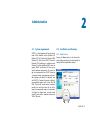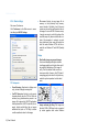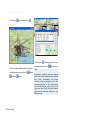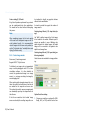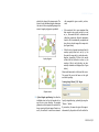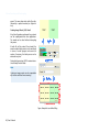
1
WASY Software
®
WGEO 4.0
Georeferencing, Geoimaging & Transformation
User’s Manual
WASY
Gesellschaft für wasserwirtschaftliche
Planung und Systemforschung mbH
Preface
This manual gives you information to the use of the WASY-Software WGEO 4.0.
The structure of this manual reflects the modular structure of the software package.
Chapter 1 and 2 give an introduction and an overview to the modules. Chapter 3 describes the georeferencing and geoimaging with the modi WGEO 4.0 Basis and WGEO 4.0 plus. The description of
the batch mode follows in chapter 4.
Copyright
Information contained in this document is subject to change without notice. No part of this work may be reproduced
or transmitted in any form or by any means, electronic or mechanical, without the express written permission of
WASY GmbH.
©Copyright. 2005. WASY GmbH. All rights reserved.
WASY and WGEO are registered trademarks of WASY GmbH. ESRI and ArcView are registered trademarks of ESRI.Inc. The
names of other companies and products herein are trademarks or registered trademarks of their respective trademark
owners.
WASY
Gesellschaft für wasserwirtschaftliche
Planung und Systemforschung mbH
Waltersdorfer Straße 105
D-12526 Berlin
Telephone:
Fax:
E-Mail:
Internet:
ii | User’s Manual
+49(0)30-67 99 98-0
+49(0)30-67 99 98-99
[email protected]
http://www.wasy.de
Contents
1.
1.1.
Introduction ........................................................................................... 5
Georeferencing and spatial modification of pixel data ......................................... 7
1.1.1. WGEO 4.0 Basis............................................................................................................... 7
1.1.2. WGEO 4.0 plus................................................................................................................ 8
1.2.
1.3.
1.4.
WGEO 4.0 Professional ........................................................................................ 8
Topographical map mode ................................................................................... 8
Coordinate Transformation.................................................................................. 8
2.
Administration ....................................................................................... 9
2.1.
2.2.
System requirements ........................................................................................... 9
Installation and licensing...................................................................................... 9
2.3.
2.4.
2.2.1. Demo license .................................................................................................................. 9
2.2.2. Single seat (standard) license......................................................................................... 10
2.2.3. Network license............................................................................................................. 10
2.3.1.
2.3.2.
2.3.3.
2.3.4.
2.3.5.
2.3.6.
Starting and customizing the program .............................................................. 14
Starting WGEO.............................................................................................................. 14
Selecting the mode ....................................................................................................... 15
Modifications ................................................................................................................ 15
Basic settings................................................................................................................. 16
Advanced settings ......................................................................................................... 17
Registered file-name extensions..................................................................................... 18
Button description ............................................................................................. 18
2.4.1. WGEO 4.0 Basis............................................................................................................. 18
2.4.2. WGEO plus.................................................................................................................... 21
WGEO 4.0 | iii
Contents
3.
3.1.
3.2.
Georeferencing and Geoimaging ........................................................23
3.1.1.
3.1.2.
3.1.3.
3.1.4.
3.1.5.
3.1.6.
3.1.7.
3.1.8.
3.1.9.
3.1.10.
3.2.1.
3.2.2.
3.2.3.
3.2.4.
WGEO 4.0 Basis.................................................................................................. 23
Scanning maps.............................................................................................................. 23
Open file ....................................................................................................................... 23
Additional functions ...................................................................................................... 24
Importing ASCII (text) files ............................................................................................ 26
Define table columns .................................................................................................... 26
Georeferencing ............................................................................................................. 27
Coordinate input by reference map............................................................................... 28
Entering coordinate values by keyboard ........................................................................ 29
Deriving geometry ........................................................................................................ 30
Cropping and deleting .................................................................................................. 31
WGEO 4.0 plus................................................................................................... 33
Multiprocessor mode .................................................................................................... 33
Georeferencing with background maps......................................................................... 33
Generate image catalog ................................................................................................ 37
Create image mosaic..................................................................................................... 38
4.
Batch Processing ..................................................................................41
4.1.
4.2.
4.3.
4.4.
4.5.
4.6.
4.7.
4.8.
Batch-mode task description .............................................................................. 41
Creating a batch file........................................................................................... 41
Managing a batch file ........................................................................................ 42
Adding files to a batch ....................................................................................... 43
Output rules....................................................................................................... 43
Conversion settings............................................................................................ 44
Georeference settings......................................................................................... 45
Batch Transformation......................................................................................... 45
iv | User’s Manual
1
Introduction /
Overview to the modules
1.
Introduction
The growing number of tasks involving the recording, administration, and analysis of digital
geographical data is reflected in an increasing
use of geographical information systems in the
commercial and government domains. Where
digital geographic data are not yet available for a
given area, they are typically obtained by scanning existing analog data. Any such data, possibly from differing coordinate systems, must be
referenced to a world coordinate system. Changing coordinates or transforming data into a uniform coordinate system can easily become a very
time-consuming task.
®
WGEO 4.0, the WASY georeferencing software,
efficiently addresses this issue. It is an easy-to-use
yet highly efficient tool for working with spatial
®
data. The output of WGEO 4.0 can be used by
diverse geographical information systems.
Combinations of modules can be licensed for
single-seat or network use. The modular design
®
of WGEO 4.0 together with the variable licensing permit tailoring the software according to
specific user needs.
WGEO 4.0 | 5
1 Introduction
6 | User’s Manual
1.1 Georeferencing and spatial modification of pixel data
1.1. Georeferencing and spatial
modification of pixel data
• Data file transformation: Coordinate-value
pairs in text- or dBase files can be converted
®
by the WGEO 4.0 transformation routines.
1.1.1. WGEO 4.0 Basis
• Single-point transformation: Individual points
entered by hand can also be converted.
• Georeferencing of image data.
• Optionally, georeferencing using affine or
trapezoidal transformation (conversion of pixels) or Registration only (creating of world files).
• Assigning of world coordinates by keyboard,
import functions, or georeferenced reference
maps.
• Spatially referenced deleting and cropping
using rectangular or arbitrary (polygon) selections.
• Combining of georeferenced images (copy
and paste).
• File-controlled spatially referenced deleting
and cropping.
• Batch mode: Tasks can be defined, queued,
and executed at a later time (recursive loading
is supported).
• Transformation of attributes: For shape files
containing coordinates in the attribute tables,
the respective columns can be specified for
coordinate transformation.
• Snapping: When using vector maps or coordinate tables as reference maps, snapping to
lines, and/or points can be activated for obtaining exact coordinate values.
• Loading and Editing of Microsoft- und PaintShop Pro color palettes.
• Interpretation of ASCII-files (value triples) as
point, line, or polygon geometry. The set of
points will be graphically displayed and can be
used as reference map.
• A COM interface is provided for integration of
user-specified data formats.
• Additional functions (also in batch mode):
Invert, Changing color depth, Rotation in 90°
increments, Changing compression and geotransformation format. These functions all preserve the georeferencing.
• Data inspector for quick display of attribute
data.
• Format conversion of attribute data (dBase,
ASCII).
WGEO 4.0 | 7
1 Introduction
1.1.2. WGEO 4.0 plus
1.3. Topographical map mode
In addition to all the functions of the Basis mode,
Plus mode provides further powerful functionality for georeferencing and geoimaging:
This module is optimized for georeferencing
large numbers of topographical maps. It is only
available as a network license (not described in
this manual).
• Georeferencing of vector data.
• Resampling (Change image size).
• Color images can be transparently overlaid
over georeferenced background maps to be
georeferenced via link vectors. The color palette of the background map can be dynamically adjusted. (Overlay mode).
• Generating of image catalogs and of dBase
tables containing names and extents of multiple images.
• Generating of sheet-line catalogs (ESRI-shape
file containing the individual enclosures of
multiple images). The dBase file can be used
as image catalog.
• Maps can be combined and/or tiled based on
a used-specified pattern (Mosaic function).
• Multiprocessor mode permits fast execution of
complex tasks on the respective hardware.
1.2. WGEO 4.0 Professional
This module is optimized for georeferencing of
land-register maps (not described in this manual).
8 | User’s Manual
1.4. Coordinate Transformation
Several sophisticated high-precision coordinate
transformation are already available (not
described in this manual).
2
Administration
2.
Administration
2.1. System requirements
®
WGEO is a 32-bit program and runs exclusively
under 32-bit Windows versions (Windows 98,
Windows NT 4.0, Windows Me, Windows 2000,
®
Windows XP). Note that as WGEO is based on
Microsoft COM technology, its usefulness under
Windows 95 will be limited and WASY does not
®
support WGEO for Windows 95. There are no
specific hardware requirements. Of course, im®
age size (uncompressed, see WGEO status bar
at window bottom), processing time, and available hardware are related. To effectively work
®
with WGEO , a Pentium-III processor or better is
recommended together with at least 256 MB
RAM. Physical and virtual memory combined
should be at least three times the size of the
largest (uncompressed) image to be processed.
To display the digital maps, true-color mode
should be used with a minimum resolution of
1024 x 768 pixels.
2.2. Installation and licensing
2.2.1. Demo license
Pressing the Demo button in the license information dialog activates all plus functionality for
testing with the included demo data set.
WGEO 4.0 | 9
2 Administration
®
WGEO 4.0 Demo mode makes the combined
Base and Plus mode functionality (except for
Parcelling-map and Topographical-map mode)
available for testing using the included demo
data. All transformation methods, georeferencing and image editing functions can be used
with the demo data; however, single-point transformations require a valid license.
In demo mode, user data can be used for georeferencing but cannot be saved.
2.2.2. Single seat (standard) license
This dialog is used to enter license keys that activate single-seat licenses for WGEO Basis, WGEO
Plus, or for coordinate transformation.
2.2.3. Network license
Connecting to the license server
®
User and company names are entered in the
Name and Organisation fields, respectively. Serial
number and Product key are obtained together
with the software.
If WGEO 4.0 is licensed by a floating (network)
license, this dialog serves to select the license
server that manages the licenses. All available
licenses are displayed in the dialog as soon as a
connection to the server is established.
Note that all view windows need to be closed
before changing the license.
To connect to the license server
• Enter the license-manager Hostname. If the
local computer serves as license manager, enter "localhost" (if no local license-manager installation is found, a dialog is displayed from
which a local installation can be started).
• Push the Connect button. Upon successful
connection, the license-server host identification (HOSTID) is displayed. An error message
is displayed should the connection attempt
fail.
10 | User’s Manual
2.2 Installation and licensing
The currently installed licenses of the license
server are listed in table format (see also above
concerning the applications). The following columns are shown:
• Application: Name of the licensed application. Renaming the application has no effect
on this value.
• Select one of the available licenses. The OK
button becomes enabled if the selected license
matches the current application (in this case,
WGEO Version 4.0).
Licensing of different applications
• Version: Licensed version of the application
("x" is a wildcard character for any numeral).
Note that network licenses are downward
compatible so that, for example, a WGEO 4.0x
license can also be used for WGEO 2.1.
• Options: A string indicating appliaction installation level, e.g., licensed modules in WGEO.
• Number: Number of simultaneously usable
licenses.
The license-administration tool can manage the
licenses for all WASY products. By default, only
information pertinent to the current appliaction
is displayed. Check "Show all" to see all available
licenses at the license server for all WASY applications. Note that licenses also can be installed for
applications other than the current one.
• Free: Number of currently available licenses.
An invalid license is indicated by a minus symbol in this column; typical causes are license
expiration or a change in dongle ID (see also
License information).
List of available licenses:
License information:
2.2.3.1. License Parameters
This dialog displays current license parameters. It
also serves to enter new or changed license information
WGEO 4.0 | 11
2 Administration
• Expiration date: For time-limited licenses, the
date of expiration, otherwise Unlimited. Valid
formats include
(a) dd-mmm-yyyy
31-mar-2002
(b) yyyy/mm/dd
2002/03/31
(c) dd.mmm.yyyy
31.03.2002
dd – day, mmm – month, yyyy – year
• Number of licenses: Number of simultaneously usable licenses.
Entering license information
Each WASY license includes eight parameters.
They are to be entered as follows:
• Server host ID: Each license is tied to a specific license server identified by a unique
HOSTID. As this ID is supplied by the hardware dongle, using the correct dongle is essential when installing a new license. This parameter is not editable
• License type: Licenses are either of network or
of single-seat type.
• Application: Enter the name of the software
application (without the .exe extension) that is
to be licensed. The name is not case-sensitive
• Version: The licensed version of the application. The ‘x’ is a wildcard character representing an arbitrary numeral. All versions up to the
entered version number (‘x’ is internally replaced by ‘9’) can use this license
12 | User’s Manual
• Options: A string of characters indicating the
modules of the licensed application that are
activated by this
• Key code: A checksum over all entered license
parameters. Any change to a parameter will
also change the key code. The following rules
apply when entering the key code
(a) Characters are not case-sensitive,
(b) The letter O is interpreted as zero
(c) All characters outside the ranges A – Z,
a – z, and 0 - 9 are ignored
Except for the Options parameter, entered
characters are generally case-insensitive. The
options string is passed to the licensed application. WGEO treats this string also as caseinsensitive
The
toolbar can be used to
go to previous or to the next license, to clear all
fields for entering a new license, to delete a li-
2.2 Installation and licensing
cense, and (to avoid misspellings) to enter all
parameters via Windows clipboard. The last option is available if the license has been sent by email and is of the following format:
• ServerHostid:
<License-server host ID>
• ClientHostid:
<Empty> or
<Client host ID>
• Application:
<Application name>
• Version:
<Application version>
• Expiration Date:
<Expiration date>
2.2.3.2. License-server status
The status dialog displays the current values for
the internal parameters of a license-server. Any
license server within the network can be monitored.
The information displayed can be useful in solving license problems. If the protocol option of
the license server has been activated, a status
snapshot can be sent directly by e-mail to WASY
support.
• Number of License <Number of licenses purchased>
• Options:
<License options>
• Keycode:
<24-character key code>
For example:
ServerHostID:
7270167e
ClientHost ID:
Application:
WGEO
Version:
4.xx
Expiration Date:
25-oct-2003
Number of Licenses:
2
Options:
201-TEST
Keycode: 074491E4275988EAAE37E585
2.2.3.3. Active User Display
Current license users
This dialog lists all current users of all licenses
managed by the license server. In addition to
user name the application, its licensed version,
the host (computer) name, display status, and
time of license-server log-in are shown.
WGEO 4.0 | 13
2 Administration
of file (EOF)" received by the license server indicates that the client has properly terminated the
application. The license manager then makes the
respective license available for new client requests.
In case of accidental disconnection, for example,
due to a client system crash, the license manager
receives no information that the license is no
longer used and the license must be released
manually as follows
• select the connection,
• User: Name of the user running the licensed
applications
• Application: Original name of the application
(renaming the application has no effect on
this value).
• Version: The version number of license, displayed up to the third digit after the decimal
point
• Host: Name of the remote host (client) running the application
• Display: Only relevant to X11 applications
(such as FEFLOW) that may redirect their output to a remote display. For WGEO, this value
should always be "local".
• Login: Start time of license use
Disconnecting a client from the license server
Each current license client maintains an open
TCP/IP connection to the license server. An "end
14 | User’s Manual
• push the Disconnect button,
• push the Refresh button to ensure that the
license becomes again available
2.3. Starting and customizing the
program
2.3.1. Starting WGEO
WGEO is started via the WASY entry in the in the
Programs folder of the Windows Start menue.
The program Window WASY Geoimaging is
displayed on the screen.
In the File menue there are the common menue
items New, Open, Exit and the last six used files.
Furthermore you find here the menue items
Modus, and Preferences which are described
later in this chapter.
Via the menue Help you get Information to the
software version and access the license dialog
and the online help.
2.3 Starting and customizing the program
2.3.2. Selecting the mode
2.3.3. Modifications
File menue | Modus
View menue | Toolbar | Modify
Click Modus in the File menu and select one of
the provided modes (Standard, Professional or
Topographic).
In the dialog box Customize you can make several settings respectively commands, toolbars,
menus, styles and options.
The selection is regulated by the installed license.
For example you can select the display style of
menus and toolbars according to personal preference from the following list of Microsoft Office
versions:
• Office 97 ,
®
• Office 2000 und
®
• Office XP
®
• Office 2003
®
• Windows XP
®
The style selection has no effect on the function®
ality of WGEO .
WGEO 4.0 | 15
2 Administration
2.3.4. Basic settings
File menue | Preferences
Click Preferences in the File menue to access
the dialog box WGEO Settings.
• File access: Activate to map image file to
memory so that (relatively fast) memoryaccess instead of (relatively slow) file-access
routines can be used to read from and write to
the image. For some NOVELL Netware servers,
it may be necessary to switch this option off as
saved files may only become visible after a restart of the computer. In contrast, no problems should arise when using this option for
local files under Windows NT/9x and for remote files on Windows NT and UNIX (Samba)
servers.
Display
TIFF Interpreter
• Black/white images as grayscale images:
Uses an anti-aliasing technique to obtain a
visual image quality much higher than would
be possible by displaying a 1-bit image directly. Thin lines remain visible even for extreme zoom levels. However, the CPU load of
computing gray-level values for all pixels may
make this option impractical on older hardware.
• Show Warnings: Deactivate to display errors
only, activate to display warnings also.
• GeoTIFF Extension: Activate to write geoinformation directly into the TIFF file. When deactivated, any geoinformation present in an
®
image will be ignored by WGEO Applications
that implement the GeoTIFF extension (for example, ArcInfo and ArcView) do not require
additional files (such as TFW files) to obtain
world-cooordinate values for the image.
16 | User’s Manual
• Image rendering by tiling: Tiles image into
blocks of 2048 x 2048 pixels each as required
by certain graphics cards under Windows
2.3 Starting and customizing the program
95/98 that may otherwise fail to display very
large images (> 64 MB uncompressed). The
option is activated automatically if an internal
error code indicates failure of the standard
display function to display the entire image.
• Auto-pan: Pans view to the vicinity of the
currently selected reference point once a first
approximation of the world transforamtion is
obtained.
• Panning by middle mouse button: Enables
panning by middle mouse button when using
a 3-button mouse. Defaults to right mouse
button for a 2-button mouse.
Options
• Force square pixels: During the imagegeoreferencing process an optimum pixel size
is calculated, usually with different X and Y
values. Square pixels are not generally suitable
for georeferencing but may be required by
other applications. For example, some imageprocessing applications read only the X value
and use it for Y as well, thus distorting images
with non-square pixels. To force square pixels,
activate this option, start the georeferecing
with the existing world file, and save the result.
• Force WGEO MAP file: Saves a WGEO MAP
file with any image. The map file stores all
relevant information such as image extent and
transparancy, reference points, selection polygon, rms error norm, etc., in ASCII format.
2.3.5. Advanced settings
File menu | Preferences | Enhanced
• Enable background processing: CPUintensive operations will performed in a separate background thread, keeping WGEO fully
interactive and ready for additional tasks in
other documents. For example, the next image can be set up for processing while another
one is already being processed. Four priority
levels are available: Normal, Low, Minimal,
and
Idle.
Usually, the best results are obtained by setting the priority level to 'Idle' where background execution is restricted to periods
without interactive requests (mouse movements, key strokes, etc.), resulting in virtually
no impediments for the user. However, in a
multi-user environment such as Windows
Terminal Server, the idle state may rarely occur and a higher priority will then be required.
• Minimize while processing: If checked, all
windows of a document are minimized during
a time-consuming operation to make the
desktop available for other tasks. Upon completion of the respective operation, all windows are automatically restored.
• Number of threads: Distribution between
processors.
• Registered components: Displays tree diagram of registered COM components sorted
by category. Using the
toolbar, new
WGEO 4.0 | 17
2 Administration
components such as transformation methods
can be registered, components can be removed from the registry, and property pages
of components and categories can be accessed.
2.3.6. Registered file-name extensions
File menu | Preferences | File types
®
WGEO 4.0 can be associated with various file
types. Double-clicking a file of an associated type
®
will automatically launch WGEO 4.0. The previous association is saved and will be restored once
the file type is no longer to be associated with
®
WGEO 4.0.
List of file types that can be associated with
®
WGEO 4.0, and their name extensions:
2.4. Button description
2.4.1. WGEO 4.0 Basis
Button
Action
Create a new, empty file (either image or batch file)
Open existing file
Open ESRI Geo-objects (requires ArcObjects)
Save active file
Cut
Copy
Paste
18 | User’s Manual
2.4 Button description
Button
Action
Undo last action (single-level)
Write new tasks to batch file
Open Data inspector for quick display of attribute data
®
WGEO 4.0 – Help
Measuring tool
Rectangular selection
Polygon selection
Select all
Delete selection (see also Rectangular and Polygon selection)
Crop (keep only selection) (see also Rectangular and Polygon selection)
Snap reference points to line
Snap reference points to point
Clone active window
Fit entire map to window
WGEO 4.0 | 19
2 Administration
Button
Action
Magnify current view extent
Shrink current view extent
Pan view extent
Restore previous view extent (up to 10 levels)
Select transparent color in image
Replace image colors by their respective complements
Convert image to gray levels
Rotate image by 180 degrees
Rotate image by 90 degrees, clockwise
Rotate image by 90 degrees, counter-clockwise
Open Edit color palette
Open Georeferencing dialog
Open Transformation
20 | User’s Manual
2.4 Button description
2.4.2. WGEO plus
Button
Action
Overlay mode (Georeferencing using background maps)
Multiprocessor mode
Center extent of working map within selected area of background map
Move working map
Rotate map
Scale working map (enlarge or shrink)
Set link vectors from working map to background map
Delete all link vectors
End overlay mode
WGEO 4.0 | 21
3
Georeferencing and Geoimaging
3.
Georeferencing and Geoimaging
3.1. WGEO 4.0 Basis
3.1.1. Scanning maps
Extra menu | Scan image...
• Windows Bitmap (*.bmp)
• PC Paintbrush file(*.pcx)
• Georeferenced pixel file (*.map, *.tfw, *.jgw,
*.bpw *.tab)
Scan an image via TWAIN. The scanned images
are loaded automatically into WGEO.
• ESRI Shape (*.shp)
3.1.2. Open file
• dBase IV (*.dbf)
®
WGEO 4.0 can open various registered file types
by several methods:
• AutoCAD Exchange format (*.dxf)
• ASCII Text table (*.txt, *.dat)
• WGEO Batch (*.wbp)
®
• Via File menu | Open…
• WGEO Project (*.wp1) [Topo-map mode]
• Double-clicking (in Widows Explorer) on a file
of registered type.
WGEO Project (*.wp2) [WGEO Professional]
• Dragging a file of registered type by mouse
from Windows Explorer into the WGEO window.
• PersonalSDE
Files of the following formats can be opened:
®
®
Some ESRI file formats require ArcObjects:
• ArcSDE
• Coverages
• TIFF raster image (*.tif, *.tiff)
• JPEG raster image (*.jpg, *.jpeg)
WGEO 4.0 | 23
3 Georeferencing and Geoimaging
Note:
Additional user-specific file formats can be provided via COM interfaces.
3.1.3. Additional functions
Rotate image by 90°/180°/270°:
Both raw and georeferenced images can be rotated in 90° increments. For example, raw images can be rotated into the correct orientation
for easier image registration afterwards.
When rotating a georeferenced image, the rotation information is stored in the world file. To
undo the rotation later, simply georeference the
image again using the world file (Load image =>
Open Georeferencing dialog => Push Start).
Transparency color:
A background color
can be defined that becomes transparent when
pasting map portions into another map. This
color can be set explicitly via the 'Select' option
or by clicking on a pixel (after zooming in sufficiently) that has the desired color. By default, the
brightest pixel color is set to transparent. When
saving a WGEO MAP file, the transparancy color
is stored in that file. However, this information is
not available to other applications (except WASY
FEFLOW).
24 | User’s Manual
Invert image:
Replaces each image color by
its complement on a scale of 0 through 255.
Replaces each image
Grayscale image:
color by a gray level while maintaining image
brightness and color depth.
Reduce color depth: Decreases number of colors in the current image to 2 (1 bit), 16 (4 bits),
or 256 (8 bits) colors.
Increase color depth: Increases number of colors in the current image to 16 (4 bits), 256 (8
bits), or 16 million (24 bits) colors.
Reducing color depth with color table:
(With image loaded) Image menu | Image size
Use an existing color table to reduce the color
depth.
Using the Optimized (MedianCut) option will
typically result in the closest match of the original colors. Alternatively, color values can be
taken from the source image or from an external color table (optionally, the external table
can be extracted from an image). When specifying an external table, Floyd-Steinberg error diffusion can be applied whereby adjacent pixels are
included in the calculation of new color values.
Edit color palette:
Images with a color
depth of eight bits (256 colors) include a color
palette that can be edited, saved and used in
other images as well.
3.1 WGEO 4.0 Basis
Save color palette: Saves current color palette in
Microsoft or Paint Shop Pro format.
Enlarge image: Doubles the DPI value of the
image (maintaining image aspect ratio). This
function can also be used in batch mode.
Shrink image: Reduces the DPI value of the image by one half (maintaining image aspect ratio). This function can also be used in batch
mode.
Image size ...: Different methods are available to
edit the size of the image, including pixel numbers, percentage of original size, and physical
print size.
Colors can be selected directly in the palette or
using the eyedropper tool in the image. Doubleclicking a color in the palette opens a dialog for
selecting a new color or entering new color values.
Palettes can be saved (and thus made available
for other images) via the Image menu in Microsoft- or PaintShopPro format. Existing palettes in
these formats can be immediately applied using
one of the following color-distribution options:
• Color index,
• Find similar colors,
• Dithering (error diffusion).
Load color palette: An existing Microsoft or
Paint Shop Pro color palette can be applied to
the current image.
• Size in pixels: Specify new pixel numbers.
• Percentage of original size: Specify percentage values to be applied to the original size.
• Physical print size: Specify either of the related parameters print size, resolution (DPI), or
scale. The respective other parameters are
automatically updated.
These methods can also be used in batch mode.
Data inspector:
The data inspector provides
a quick display of current attributes and their
respective values. Attributes for image data are
per pixel (RGB values), those for vector data are
per element.
The data inspector is a dockable window, i.e., it
can be docked at the desired window position.
WGEO 4.0 | 25
3 Georeferencing and Geoimaging
3.1.4. Importing ASCII (text) files
• decimal separator symbol,
File menu | Open | File type *.txt or *.dat
• data-record separator symbol,
Given the following information, ASCII files can
be loaded as tables:
• column separator symbol (see Figure).
• whether the first row contains column headers
For easy reference, the top portion of the file is
displayed at the bottom of the dialog.
3.1.5. Define table columns
For ASCII and dBase files, coordinate columns
and the implied geometry must be defined.
(With table loaded) Table menu | Define columns...
Interpret data records as:
26 | User’s Manual
3.1 WGEO 4.0 Basis
- Points,
- Line, or
- Polygon
X-coordinate column:
- Column containing X-coordinate values
wiederherstellen: minimiertes Fenster doppelklicken or click and select restore).
Close:
Start:
Y-coordinate column:
- Column containing Y-coordinate values
Z-coordinate column:
Import:
- Column containing Z-coordinate values
Given this information, the table can be transformed and/or the geometry displayed (making
the data available as reference map). The table
can be reconverted to a dBase or an ASCII file
anytime using Save as….
Export:
Preview:
3.1.6. Georeferencing
Map menu | Georeferencing
RMS:
Add a new reference point with windowcenter coordinate values to the work map. World
coordinates can be entered manually or retrieved
from a point on the reference map by doubleclicking that point.
Delete previously selected reference point.
Minimize dialog window (to restore, double-click the minimized window or Fenster
Closes dialog.
Starts referencing process. In batch
mode the Start button is relabeled to
Batch and pushing it adds the current
task to the batch. Processing commences once the batch file is started.
Loads a world file for georeferencing,
imports data from WGEO-MAP file,
®
®
ESRI -world file, MapInfo -tab file or
from a regular text file.
Saves a world file, exports data to
®
WGEO-MAP file, ESRI -world file, or
®
MapInfo -tab file.
Opens a dialog displaying the result of
the selected rectification for a regular
grid so that any gross errors made in
defining the reference points become
apparent.
Square root of the mean squared deviation between predefined and calculated points.
ImageX:
Edit field for the image x-coordinate
value.
ImageY:
Edit field for the image y-coordinate
value.
RealX:
Edit field for the world x-coordinate
value.
RealY:
Edit field for the world y-coordinate
value.
WGEO 4.0 | 27
3 Georeferencing and Geoimaging
Weight:
Edit field for the weight to be given to
the
currently
selected
reference
point(s) during the transformation
calculation. Weight values do not have
to be whole numbers. A zero weight
value results in the respective reference
point being ignored during the transformation (use during testing to avoid
the need to delete a given point).
Referencing methods:
Registration: No image conversion is performed, only the
transformation is saved. Use for
scaling and shifting only.
Transformation:
xr = Axi + B
yr = Cxi + D
Standard rectification: Affine
transformation - image can be
scaled, rotated, and shifted. A
new image is computed.
Trapezoidal rectification: Image can be scaled, rotated,
shifted, and corrected for nonparallel distortion. A new image
is computed.
Transformation:
xr = Axi + Byi + Cxi * yi + D
yr = Exi + Fyi + Gxi * yi + H
3.1.7. Coordinate input by reference map
(With image loaded) Map menu | Load reference
map
Makes pixel or vector maps, GeoObjects, or
tabulated coordinate values available as reference maps for Georeferencing a work map.
First, mark a reference point on the work map.
Next, double-click at the corresponding location
in the (already georeferenced) reference map to
set an associated reference point. Referencepoint locations in either map can be modified at
any time using the mouse, coordinate-values are
updated automatically as needed. Using the
Snap function (Map menu or
), points or
lines can be precisely selected. Snapping is not
available for raster images and ESRI GeoObjects.
Hint:
Transformation:
28 | User’s Manual
xr = Axi + Byi + C
yr = Dxi + Eyi + F
Multiple reference maps can be loaded for georeferencing a work map.
3.1 WGEO 4.0 Basis
3.1.8. Entering coordinate values by keyboard
WGEO 4.0 | 29
3 Georeferencing and Geoimaging
3.1.9. Deriving geometry
(With table loaded) Window menu | Geometry
Geometry can be derived from tabulated values
(imported from ASCII or dBase file). First, define
30 | User’s Manual
the correct interpretation of the data columns as
point, line, or polygon geometry.
The resulting geometry can be used as reference
map for georeferencing. Use Save as... to export
geometry data to an ASCII or dBase file.
3.1 WGEO 4.0 Basis
3.1.10.
Cropping and deleting
Scanned images (maps) have edges or other
undesired areas which have to remove afterwards. The resulting maps after the referencing
process also have no exact rectangular form. …
Rectangle selection
View menu | Rectangle selection
Click and drag in the active window to open a
rectangle. Drag the rectangle handlers (small
black squares) to modify size and shape of the
rectangle. Placing the cursor within the rectangle
changes its appearence to an arrow cross, indicating pan mode where the rectangle can be
panned using the mouse. The rectangular selection can be deleted or copied, or the image can
be cropped keeping only the selected portion.
The georeference is maintained in all
WGEO 4.0 | 31
3 Georeferencing and Geoimaging
cases. Using Save selection (Edit menu), the
rectangle can be saved for future use in ESRI
Shape or Generate format. Saved selections can
be loaded using Load Selection.
The polygon can then be edited in various ways:
Delete point: While the polygon is incomplete
(has not been closed), clicking on a point deletes
all subsequent points and connecting lines. To
delete a point from a completed (closed) polygon, simply drag it outside the window.
Add point: Placing the cursor above a connecting line of the polygon will change its appearance to a black square, indicating that by a left
mouse click a new point can be set there.
Move point: Placing the cursor above a point of
the polygon will change its appearance by adding a cross, indicating that the point can be
dragged to a new location using the left mouse
button.
Lines and points of the selection can be used for
snapping.
Polygon selection
View menu | Polygon selection
A polygon can be created to serve as image selection for deleting, copying, and cropping. The
georeference is maintained in all cases.
Use the left mouse button to set the individual
points forming the polygon. The polygon is
automatically closed once the start point is
clicked again or after a double-click on a point.
32 | User’s Manual
Move polygon: Placing the cursor inside the
polygon will change its appearance to a cross,
indicating that the polygon be dragged to a new
location using the left mouse button.
Save polygon: Using Save selection (Edit
menu), the rectangle can be saved for future use
in ESRI Shape or Generate format.
Load polygon: Saved polygon selections can be
loaded using Load selection (Edit menu). External files (Shape, ASCII) can also be loaded. However, only the first of possibly several polygons
will be loaded from a Shape or ASCII file. To
apply multiple selections to an image, WGEO
Plus batch mode is required.
3. WGEO 4.0 plus
3.2. WGEO 4.0 plus
3.2.1. Multiprocessor mode
Standard toolbar
®
WGEO 4.0 plus makes full use of multiple processors when available. This can dramatically boost
performance; for example, time needed for image rectification drops by more than 50% when
using a two- instead of a single-processor machine.
Lines and points of the selection can be used for
snapping.
3.2.2. Georeferencing with background
maps
(With image loaded) Map menu | Background
maps
Images (work maps) with scan coordinates can
be shifted, rotated, scaled, and georeferenced
using a georeferenced background image. The
work map is displayed partially transparent in
overlay mode over the background map. Color
depth of either map can be up to 24 bits.
Open the Background maps dialog (
) at any
time to add or remove maps, to change their
sequence, to set a zoom extent, or to edit image
properties (see Figure).
WGEO 4.0 | 33
3 Georeferencing and Geoimaging
The image-properties dialog contains a selection
of different graphics-display options (OpenGL,
DirectX und Direct3D) and overlay parameters.
To preserve settings between WGEO sessions,
check the "Use as standard settings" box. The
color palettes of background maps can be adjusted in brightness, contrast, saturation, and
RGB values. To only change a particular color of
the palette, double-clicking it opens another
dialog where the color can be edited.
Rotates work map
Scales work map (increasing or decerasing its dimensions)
Sets link vectors from work to background map
Deletes all link vectors
Ends overlay mode
Centers total extent of the work map
within the displayed window extent of
the background map
Shifts work map
34 | User’s Manual
In Shift
mode the following mouse functions
are also available:
Shift:
Left mouse button
3.2 WGEO 4.0 plus
Scale:
Left mouse button + Shift key
Rotate: Left mouse button + Ctrl key
The shift, rotate, and scale functions maintain
the x/y image proportionality. Link vectors
can be used to also achieve an image distortion. While link vectors are being set, the
other functions become disabled and remain
so until all link vectors are deleted.
Ideally, at least four link vectors should be set
near the border of the work map. To set a link
vector, click on the desired work-map position,
drag the mouse (keeping the left button
pressed), and release it over the desired background-map position. The most recent link vector can be deleted using the backspace key. To
delete several links (reference points), use the
georeferencing dialog; this is possible at any
time. The georeferencing dialog also displays the
work-map image coordinates together with the
associated background-map world coordinates
and the respective RMS.
Add background map
.
Distance between respective reference points
and RMS error norm indicate the quality of the
match. Red and green markers indicate actual
and desired position, respectively. Match quality
may be enhanced by modifying the existing link
vectors, by adding more link vectors (the number of link vectors is not limited), or by introducing link-vector weighting factors.
WGEO 4.0 | 35
3 Georeferencing and Geoimaging
Zoom image
and center work map
.
Set link vectors
(reference points) for precise
work-map positioning. Start
Perform a rough positioning of the work map on
the background map using the Shift
, and Scale
36 | User’s Manual
tools.
, Rotate
georeferencing.
Note:
Automatically calculated work-map reference
points (with world coordinate-values obtained
from current transformation and imagecoordinate values) are displayed in blue color.
Georeferencing based on link vectors ignores
these internal reference points. Only if no link
sectors have been set are the internal reference
points used for referencing, resulting in a zeroRMS error norm.
3.2 WGEO 4.0 plus
®
Pushing the Start/Batch button in the
georeference dialog start the georeferencing
process / adds the task to the batch.
Requires WGEO 4.0 plus license
3.2.3. Generate image catalog
• Image catalog. Image-extent coordinates are
stored as a table in dBase file format.
Extra menu | Generate image catalog
• Sheet-line catalog. Image extents are stored
as polygons in ESRI shape format. The polygons may overlap as needed.
A catalog contains information of georeferenced
images. There are two types of catalog available:
A wizard is provided to support the creation of
catalogs.
Create catalog (1/3): Input data
Use "Add" to add an image to the list of images
to be included in the catalog. Different input
directories are possible.
Create catalog (2/3): Output
Select the catalog type and specify a target file,
optionally by using the "Browse..." button. The
target directory will be automatically created if it
is new.
! Please use different file names when simultaneously creating an image catalog and a sheet-line
catalog in the same target directory. Alternatively, create a sheet-line catalog and use its
dBase as an image catalog.
WGEO 4.0 | 37
3 Georeferencing and Geoimaging
Create catalog (3/3): Result
A log lists all operations performed. Log contents
can be copied/pasted into other applications.
The wizard can be closed without interrupting
the process.
Note:
When combining images, the first color palette
will be used for all subsequent images as well. To
avoid undesired results, it is recommended to
store all images with the same color palette (using the “find similar colors” method) before cataloging. (See Batch mode).
3.2.4. Create image mosaic
Extra menu | Create image mosaic
®
Requires WGEO 4.0 plus license
be visualized in virtually any graphics software
without further modification.
A wizard is provided to support the creation of
image mosaics.
Creating Image Mosaic (1/4): Input data (image)
Use "Add" to add an image to the list of images
to be loaded for the mosaic. Different input directories are possible. In case of differing color
depths between the loaded images, all loaded
images will be converted to the greatest color
depth found among them.
Creating Image Mosaic (2/4): Input data (partitioning template)
Select between two methods for image partitioning.
To effectively use images such as topographical
maps or aerial photographs with GIS or other
visualization software, it is often desirable to
convert the georeferenced image to an image
mosaic, i.e., an image consisting of rectangular,
nonoverlapping tiles.
When working with rectangular image tiles, only
those tiles need to be loaded at any one time as
are needed for the respective on-screen view.
This reduces the need for memory swapping and
can dramatically speed up the responsiveness of
the software.
If the tiles are created so that ‘no-data’ image
areas are excluded, the resulting image tiles can
38 | User’s Manual
Option Sheet-line catalog
1.
Polygons are read from a polygon file (ESRIShape, ASCII, or DXF) and are used as tem-
3.2 WGEO 4.0 plus
plate for the shape of the image mosaic. The
extent of each individual polygon determines
the extent of the corresponding image in the
mosaic. Irregular polygons are permitted.
Input polygons
cally computed for given a and b, and vice
versa.
• If the number of tiles is more important than
their respective size, specify values for n and
m, i.e., the number of tiles in x-direction and
y-direction, respectively. Values for parameters
a and b will be automatically computed and
show the size of each image tile in map units.
(see Figure below).
• If the tile size is of greater importance than tile
number, specify values for a and b, i.e., the
tile extent (in map units) in x-direction and ydirection, respectively. All tiles in the mosaic
will have this size. Values for n und m, i.e., the
number of tiles in each direction, are automatically obtained and displayed (see Figure
below).
Mosaic and frame match at the lower left corner.
The mosaic fully covers the frame on the right
and at the top edge.
Creating Image Mosaic (3/4): Target
Output mosaic
2.
Option Regular partitioning: Set either the
individual extent or the total number of image tiles in a given direction. The constant
parameters w and represent the extent of the
frame covering all input images. Based on w
and h, the values for n and m are automati-
Specify a target directory, optionally by using the
"Browse..." button.
By convention, the name of a given tile image is
determined by the position of the tile within the
WGEO 4.0 | 39
3 Georeferencing and Geoimaging
mosaic. The name always starts with a file prefix,
followed by a position number (see Figure below).
Creating Image Mosaic (4/4): Result
A log lists all operations performed. Log contents
can be copied/pasted into other applications.
The wizard can be closed without interrupting
the process.
A batch file will be created. Once started, the
mosaic-creation batch process can be monitored
in terms of overall progress and current tile
number. If necessary, the batch process can be
aborted at any time.
During batch processing, WGEO remains interactive and ready for other tasks.
Note
Creating an image mosaic can be computationally intensive and thus time-consuming.
Figure: Example of user-defined tiling
40 | User’s Manual
4
Batch Processing
4.
Batch Processing
4.1. Batch-mode task description
Rectify image: Georeferencing of an image requires reference points with geographic coordinates. Based on these, the image will be rotated
and rectified as needed, using one of three possible referencing methods. Depending on the
task in Batch mode or during Save as… the
coordinates are saved with the image (GeoTIFF)
or in an additional geotransformation-control
(world) file (*.map, *.tfw, *.tab ...).
Transform coordinate system: Georeferenced
images (TIFF, JPEG, BMP), vector data (ESRI
shapes & DXF), and user-specific formats can be
transformed to a different coordinate system.
See Transformation.
Convert and modify image: Different functions
can be applied to an image, including rotation in
90-degree increments, change of color depth,
color inversion, change of image format (e.g.,
TIFF to JPEG), change of compression type,
change of transformation format (*.map, *.tfw,
*.tab).
Cut or crop image using polygon: Based on a
polygon (ESRI shape, ASCII, or MAP) file of the
same title as the input file, the image is cut or
cropped. Deleted areas can be optionally filled
with a background color.
Change image size: Different methods are
available to change the image size, including
number of pixels, percentage values, and physical print size. Size can also be changed via DPI
and scale settings.
Apply color palette to image: Existing color
palettes in Microsoft or Paint Shop Pro format,
or the palette of a reference image can be applied to several images, using one of several
possible methods.
Repair ESRI Shape files: Corrects minor errors in
a shape file.
4.2. Creating a batch file
Either of the following two methods creates a
batch file
WGEO 4.0 | 41
4 Batch Processing
in the File menu and select “New
Click New
batch file”. This will open the batch-control dialog.
If the batch button
is active, all tasks defined via the Georeference and Transform dialogs are written to a batch file. The buttons Start
and Transform in these dialogs are relabeled to
Batch. Clicking the Batch button opens the
batch-control dialog.
The WGEO plus function Create image mosaic
also employs the batch-file mechanism
To begin batch execution, press the Start button
in the batch-control dialog.
4.3. Managing a batch file
Extensive, repetitive tasks are best handled in
batch mode. Jobs can be defined and queued for
execution at a suitable time. This can also help
to optimize the load on the computer. Each job
includes a specific task and identifies source,
parameter, target, and geotransformation (.tfw,
.tab, .map) files.
If georeferencing parameters are not available in
a file, they can be included in the batch file us®
ing the WGEO Referencing tool. Once created,
the batch file can be executed at any time. For
example, the batch process can be started after
work in the evening so that the processed maps
are available the next morning.
42 | User’s Manual
• Close: Closes batch dialog after prompting for
saving.
• New: Adds files for new task to batch. Opens
Adding files to batch
• Delete: Removes file from batch.
• Reset: Finished tasks (‘done’ status) can be
reset to ‘wait’ status.
• Start: Begins batch execution. Progress bars
display overall and current-task progress.
• Tasks: This window lists all tasks together with
source file, status, and comments.
• Properties: When a task is selected, all available information for that task are displayed
and can be modified via the respective button. (see Properties of batch jobs).
All tasks are listed together with their properties
and definitions, including, for example, file
names, a task description, current status, and a
comment.
4.4 Addign files to a batch
4.4. Adding files to a batch
The following tasks can be performed in batch
mode:
• Rectify (and, optionally, crop) image
• Transform coordinate system
• Convert and modify image
• Delete or crop image area using polygon
• Change image size
• Apply color palette to image
• Repair ESRI-shape files
from all subdirectories, select Search subdirectories. Inadvertently added files can be removed
from the batch using Remove.
Pressing <Back returns to Batch-control dialog.
Pressing Next> opens Output rules dialog.
4.5. Output rules
Use Browse... to select the target directory.
Output files are named according to the following rules:
If the check box remains unchecked, output files
names are identical to input file names.
Placing a check mark in the check box allows
modification of target directory and output file
names. As shown below, various string variables
are provided for this purpose.
Directory:
Files to be loaded do not have to be in the same
directory. To quickly add all files in a given directory, use Add all. To also recursively add files
Input
Input directory (e.g., $(InputDir) = e:\basis\input\)
Output
Target directory selected via
Browse...
(e.g., $(OutputDir) =
e:\basis\output\)
Temporary
Directory for temporary files as
specified via Windows Control
panel
(e.g., $(TempDir) =
e:\temp\)
WGEO 4.0 | 43
4 Batch Processing
Notes:
File:
Path
Input directory + file title + file
extension
(e.g., $(Path) =
e:\basis\input\raster.tif)
Name
File title + file extension
(e.g., $(Name) = raster.tif)
Title
File title
(e.g., $(Title) = raster)
Extension
File extension
(e.g., $(Ext) = .tif)
Example:
The string $(InputDir)$(Title)_tr$(Ext) results in
an output file “e:\basis\input\raster_tr.tif
Note that _tr has been manually added by keyboard.
Recursively loaded files:
To save output from recursively loaded files to a
new directory tree, variable contents must be
modified accordingly (similar to search and replace).
Syntax: $(Variable separator old string = new
string),
e.g., $(Path:input=newname) =
e:\basis\newname\raster.tif
44 | User’s Manual
If only the path [variable $(Path)] is specified in
the File combo box, the input file will be replaced
by the output file
New directories will be created as needed according to the path specification.
If files from separate input directories have identical names, their respective output files should not
be written to the same target directory as this
would result in the most recent output replacing
previous output of the same name.
<Back returns to the previous dialog Adding files
to batch. Pressing Next> opens a new dialog
depending on the task definition:
4.6. Conversion settings
Select the file format for the geographical transformation and the compression type for the
output (TIFF) image.
Please note that only the WGEO-MAP format can
store all types of pertinent image information
such as transformations, reference points, transparent color, selection polygon, etc.
Rotation
90, 180, 270 degrees, or no rotation.
Color depth
4.7 Georeferencing settings
Reduce, increase, or keep.
Method
Invert
Registration, Standard rectification, Trapezoidal
rectification
Replace each color by its complement.
Crop
Image format
Output format (TIFF, JPEG, BMP, compression
type as applicable
).
Transformation
Only applicable with WGEO-MAP file (*.map)
<Back returns to Output rules dialog. Pressing
Finish> applies all settings to the batch file
(Batch-control dialog).
World file for georeferencing (MAP, TFW, JGW,
BPW, TAB, GeoTIFF).
4.8. Batch Transformation
<Back returns to Output rules dialog. Pressing
Finish> applies all settings to the batch file
(Batch-control dialog).
In addition to general coordinate-transformation
components such as the shifting transformation,
a number of externally supplied transformation
components (e.g., by government agencies) are
available. Please keep in mind that the latter are
typically designed for a specific geographical
region of limited extent and thus are subject to
lower accuracy when applied elsewhere.
4.7. Georeference settings
Georeferencing requires a world file containing
the world transformation to be present in the
input directory. Please note that only the WGEOMAP format can store all types of pertinent image information such as transformations, reference points, transparent color, selection polygon, etc. The transformation itself can be stored
in ESRI-world- or MapInfo-TAB files as well.
When using a WGEO-MAP file, the rectangle or
polygon selection of the file can be used for
cropping.
Transformation
World file for georeferencing (MAP, TFW, JGW,
BPW TAB, GeoTIFF)
Transformation method:
Shifting or other method selection (Registration
of other methods).
Source coordinate system:
Set of applicable source coordinate systems depends on the transformation method selected.
Target coordinate system:
Set of applicable target coordinate systems depends on the transformation method selected.
WGEO 4.0 | 45
4 Batch Processing
Note!
Automatic strip selection is not compatible with
raster or vector maps in case of overlaps
Image georeferencing method:
For an image, an additional method can be
specified: Registration, Standard rectification,
Trapezoidal rectification.
<Back returns to Output rules dialog. Pressing
Finish> applies all settings to the batch file
(Batch-control dialog).
46 | User’s Manual