1
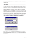
Gipuzkoa Spatial Data Infraestructure – G-Irudia
G-Irudia 2
User Manual
Introduction.................................................................................................................................. 2
System requirements.................................................................................................................. 2
Installation.................................................................................................................................... 3
Use of tools .................................................................................................................................. 4
Go to the initial map (
) .................................................................................................... 4
Obtain background (
)...................................................................................................... 4
Obtain municipality (
) ..................................................................................................... 4
Save Backdrop (
Remove backdrop (
)............................................................................................................. 5
) ....................................................................................................... 5
Identification buttons for items (
... ) .......................................................... 5
Options (
) ......................................................................................................................... 6
About.. (
) .......................................................................................................................... 7
| Gipuzkoa.net
Promotion
| Department for the Arrangement and Territorial
Gipuzkoa Spatial Data Infraestructure – G-Irudia
Introduction
G-Irudia 2 is the second version of the application created to enable a user of Autodesk
products to have easy access to the maps and the orthophotos published on the web site
(http://b5m.gipuzkoa.net).
This application will ask the Gipuzkoa Provincial Council (DFG) server for maps or orthophotos,
and will show the image obtained as the backdrop to the active drawing in the Autodesk
application.
As well as this, it will also make it possible to obtain various kinds of information (place names,
river courses, roads and buildings) about specific points.
This application has been programmed in the VBA environment that the various types of
Autodesk software have to ensure that it is completely integrated in these applications and also
has all the possibilities provided by this programming environment.
System requirements
This application has been designed and tested to operate under the following Autodesk
products:
AutoCad 2000
AutoCad 2005
AutoCad 2000i
AutoCad 2006
AutoCad 2002
AutoCad 2007
AutoCad 2004
AutoCad Map 2000
AutoCad Map 2000i
Autodesk Map 5
Autodesk Map 6
Autodesk Map 2004
Autodesk Map 3D 2005
Autodesk Map 3D 2006
Autodesk Map 3D 2005
The application might also operate properly under other Autodesk products.
An active Web connection is required for requests for maps and information.
| Gipuzkoa.net
Promotion
| Department for the Arrangement and Territorial
Gipuzkoa Spatial Data Infraestructure – G-Irudia
Installation
Fig.1: Installation of the application.
The program will be installed using an assistant. This will ask the user for various details,
including:
•
Tasks to be performed: depending on the elements that have been installed, this allows
you to select the tasks to be performed. These tasks will be:
o
Installing the program (compulsory if the program were not installed).
o
Installing the files for the button bar (see fig. 2), compulsory if the program were
not installed.
o
Loading the button bar in the Autodesk application; in normal operating
conditions the Autodesk application will close after loading the bar,
nevertheless if an error occurs, it will remain open and will have to be closed by
the user to bring the installation process to a close.
Fig.2: Button bar for the application.
•
Installation directory for the Autodesk product; directory in which you can find installed
the Autodesk product on which you want to install the application.
| Gipuzkoa.net
Promotion
| Department for the Arrangement and Territorial
Gipuzkoa Spatial Data Infraestructure – G-Irudia
Use of tools
This section will explain how the various tools work that the application provides users with
)
Go to the initial map (
This tool displays an initial working map; to view this, when you press this button, it will zoom in
on the entire area of the initial map, whose coordinates are set up in the configuration (by
default, the province of Guipúzcoa) and will automatically ask for the map that covers this initial
area with the options set up in the configuration.
As has already been pointed out, this initial map can be modified by the user through the
program configuration (see later on in this manual).
Obtain background (
)
This tool will request the map covering the area shown in the window of the active drawing
according to the options set up in the program configuration.
Before this request for the new map, if there is a previous map and it has not been previously
saved by the user, then it will be eliminated.
Obtain municipality (
)
This tool is for obtaining the map background or the orthophoto of one of the municipalities in
the province; to do this, users will be shown a list of municipalities in the province and will be
asked to choose one of them (see fig. 3).
Fig.3 “Request for a town backdrop”
To select the municipality the user can search in the list or write in its name.
When you write in the name the list will automatically select the first match that is found in this,
which will help users.
When you press the “Request” button it will zoom in the selected municipality and the map of
the area shown after the zoom will automatically be requested, always bearing in mind the
options established in the program configuration.
| Gipuzkoa.net
Promotion
| Department for the Arrangement and Territorial
Gipuzkoa Spatial Data Infraestructure – G-Irudia
Save Backdrop (
)
This option will enable the user to save a copy of the last map that has been requested; to do
this it will request the name and location of the picture file that contains this.
When you save the map the picture file will be created at the location shown and the properties
in AutoCad will be changed to assign them to the new name and location.
NOTE: Once the map has been saved, it cannot be deleted by the application.
Remove backdrop (
)
Using this tool you can eliminate the active drawing of the map you have asked for (if there is
one).
Identification buttons for items (
... )
Here you will find a set of tools under a pop-up bar, this will allow you to select the button for the
type of item about which you wish to obtain information; the possibilities will be:
•
Buildings
•
Roads
•
Rivers
•
Place names
(only valid for scales less than 1:16000)
In all these cases after pressing the button you will be asked to choose the place where you
wish to make the inquiry in order to then display the result obtained in a message box (see Fig.
4).
Fig. 4 “Information on place names”
This group of buttons may vary with the various versions of the application, although they all
operate in the same way.
| Gipuzkoa.net
Promotion
| Department for the Arrangement and Territorial
Gipuzkoa Spatial Data Infraestructure – G-Irudia
)
Options (
This shows the form that will allow you to set up certain options in the program (see Fig. 3);
these options will be:
•
Type of backdrop: Maps, Orthophotos or others; you can consult orthophotos between
the scales of 1:1.000 and 1:50.000). The number of available backdrops may vary
depending on the version.
•
Asking for place names to be included: checking box to mark whether the user wishes
to obtain place names on the requested maps or orthophotos. This option may be
disabled in certain versions of the application.
•
Language of the application: Spanish or Basque, this selects the language of the user’s
interface and the messages and texts shown to the user.
•
Setting up the initial map: this includes two options; the first one will set up the current
view of the active drawing as an initial map; in this way the user will be able to set up
initial map that is different to the one included by default in the application (complete
province). The second option will enable you to set the complete province as an initial
map.
•
Internet connection: This shows, for information purposes, details of the type of Internet
connection and its status.
| Gipuzkoa.net
Promotion
| Department for the Arrangement and Territorial
Gipuzkoa Spatial Data Infraestructure – G-Irudia
Fig. 5 “Program preferences”
About... (
)
This shows information about the product, original web site address and a contact address.
| Gipuzkoa.net
Promotion
| Department for the Arrangement and Territorial