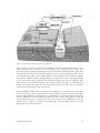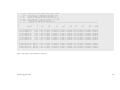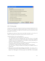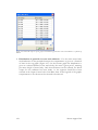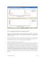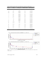
1
Manual of FOCUS TOXSWA version 2.2.1 W.H.J. Beltman M.M.S. Ter Horst P.I. Adriaanse A. De Jong Alterra-rapport 586, ISSN 1566-7197 Uitloop 0 lijn 20 mm 15 mm 10 mm 5 mm 0 15 mm 0 84 mm 0 195 mm 2 Alterra-rapport 586 Manual of FOCUS_TOXSWA version 2.2.1 W.H.J. Beltman M.M.S. Ter Horst P.I. Adriaanse A. De Jong Alterra-rapport 586 Alterra, Wageningen, 2006 ABSTRACT W.H.J. Beltman, M.M.S. Ter Horst, P.I. Adriaanse & A. De Jong, 2006. Manual of FOCUS_TOXSWA version 2.2.1. Wageningen, Alterra, Alterra-rapport 586. 198 pp. 84 figs.; 12 tables; 41 refs. The FOCUS_TOXSWA model calculates exposure concentrations in small watercourses or ponds; these concentrations are used in the pesticide registration procedure at EU level. The model concepts are shortly described. The input files and output files are described and how the model can be parameterized. Input data are stored in a relational database, except pesticide entries resulting from drainage or runoff/erosion. These are stored in separate files made by the MACRO and PRZM models, respectively. Model input and output can be accessed through a graphical user interface. The FOCUS Surface Water Scenarios can be run easily, as well as water-sediment studies. Keywords: pesticides, exposure concentration, TOXSWA, FOCUS, surface water ISSN 1566-7197 This report can be ordered by paying € 35,- to bank account number 36 70 54 612 by name of Alterra Wageningen, IBAN number NL 83 RABO 036 70 54 612, Swift number RABO2u nl. Please refer to Alterra-rapport 586. This amount is including tax (where applicable) and handling costs. © 2006 Alterra P.O. Box 47, NL-6700 AA Wageningen (The Netherlands). Phone: +31 317 474700; fax: +31 317 419000; e-mail: [email protected] No part of this publication may be reproduced or published in any form or by any means, or stored in a data base or retrieval system, without the written permission of Alterra. Alterra assumes no liability for any losses resulting from the use of this document. 4 Project 232693 Alterra-rapport 586 Alterra-rapport 586/juni/2006] Contents Preface 9 Summary 11 1 Introduction 1.1 General 1.2 Main differences between TOXSWA 1.2 and FOCUS_TOXSWA 1.3 Installation and registration 1.4 Reporting of errors and support 1.5 Documentation 1.6 Structure of user manual 13 13 14 14 15 15 15 2 Model description 2.1 Overview 2.2 Limitations 17 17 21 3 User’s guide for the command line version of FOCUS_TOXSWA 3.1 Running the model 3.2 Overview of input and output files 3.3 Description of input and output files 3.3.1 The TOXSWA input file *.txw 3.3.2 Meteo input file 3.3.3 Drainage and runoff input files 3.3.4 General output files 3.3.5 Hydrology output files 3.3.6 Representative channel output files 3.3.7 Concentration output files 3.3.8 Drainage/Runoff output file 3.3.9 Mass balances output files 3.3.10 Distribution output files 23 23 24 25 25 40 41 44 58 64 68 72 73 84 4 User’s guide for the TOXSWA Graphical User Interface 4.1 Introduction 4.2 Getting Started 4.3 Generating FOCUS Step 3 runs 4.4 Preparations 4.4.1 Running TOXSWA 4.4.2 Viewing the results 4.4.3 Special cases: substances with Koc higher than 30 000 L/kg 4.4.4 Special cases: metabolites 89 89 92 92 92 93 94 95 95 Alterra-rapport 586 5 4.5 General properties of the TOXSWA GUI 97 4.6 Projects form 98 4.7 Main form – TOXSWA project: project_name 100 4.7.1 Status bar of the Main form 101 4.7.2 Main buttons of the Main form 102 4.7.3 Browse box of the Main form 103 4.7.4 Run Components tab 104 4.7.5 Lateral Entries tab 106 4.7.6 Simulation Control tab 106 4.7.7 Output Control tab 107 4.7.8 Run Status tab 109 4.8 Editing Scenarios 110 4.8.1 The Scenarios form 110 4.8.2 The Water layers form 111 4.8.3 The Sediment form 113 4.8.4 The Meteo stations form 115 4.8.5 Hydrology Pond and Hydrology Watercourse forms 118 4.9 Editing substances 121 4.9.1 Substance form 121 4.10 Editing Application schemes 124 4.10.1 Application scheme form 125 4.10.2 Spray drift events form 126 4.11 Running the model 127 4.12 Creating graphs 128 4.12.1 Viewing output 129 4.12.2 Manipulating the graphs 137 4.12.3 Comparing two simulations 139 4.12.4 Comparing a simulation with experimental data 141 4.12.5 Plotting graphs showing differences between simulated and measured concentrations in water and in sediment 145 5 Model parameterization 5.1 Introduction 5.2 Run characteristics 5.3 Definition of water layer and sediment 5.4 Hydrology of water bodies 5.5 Pesticide loadings 5.6 Substance properties 147 147 148 148 154 154 155 6 Simulating a water-sediment study with FOCUS_TOXSWA 6.1 Introduction 6.2 Definition of the scenario 6.2.1 Water layer 6.2.2 Sediment layer 6.2.3 Temperature in the meteo data file 6.2.4 Composition of the scenario 6.3 Definition of the substance 159 159 159 160 161 164 164 165 6 Alterra-rapport 586 6.4 Definition of the application scheme 6.5 Specification of run settings 6.5.1 Initial concentration in the water layer 6.5.2 Lateral entries 6.5.3 Simulation 6.5.4 Output 6.5.5 Composition of the run 6.6 Comparison of simulated concentrations with measured concentrations 166 166 166 167 167 167 168 168 References 171 Appendices 1 Theory on effect of temperature on transformation and volatilization 175 2 Input files for FOCUS_TOXSWA 177 3 Read_me_TOXSWA text file for installation of TOXSWA 183 4 The *.txw input file for FOCUS_TOXSWA with recommended segmentation of the sediment in case of substances with a Koc higher than 30 000 L/kg 189 5 Estimation of the tortuosity factor for sediment 193 6 The *.txw input file for the example water-sediment study 195 Alterra-rapport 586 7 Preface The TOXSWA model calculates exposure concentrations to be used in the ecotoxicological risk assessment of pesticides for the aquatic ecosystem. It was released in April 1996 and TOXSWA model version 1.2 has been introduced into the pesticide registration procedure of The Netherlands in June 1999. It then replaced the simpler SLOOT.BOX model in order to be able to better estimate chronic exposure concentrations and to differentiate the estimation of exposure concentrations according to regional characteristics, like possible pesticide entry routes or water body dimensions. In the 1990s, the European Commission felt the need to harmonise the calculation of predicted environmental concentrations (PEC) of active substances of plant protection products in the framework of the EU Directive 91/414/EEC. Therefore, FOCUS (FOrum for the Co-ordination of pesticide fate models and their USe) was started. FOCUS is based on co-operation between scientists of regulatory agencies, academia and industry. Several working groups were installed; one of these was the FOCUS Surface Water Scenarios working group. The objective of the group was to develop a set of standardised modelling scenarios for three different entry routes into surface water: drift, drainage, runoff and erosion because any model calculation needs a scenario. The FOCUS Working Group on Surface Water Scenarios has chosen a specific set of models to account for the different entry routes. The TOXSWA model was chosen for the estimation of the final PECs in surface waters. The developed EU FOCUS Surface Water Scenarios consist of water bodies that have a transient flow regime caused by variable water entries by runoff or drainage via macropores. The released TOXSWA model version, 1.2, was suitable to simulate slow flows in Dutch ditches, but could not simulate the behavior of pesticides in small surface waters with highly variable discharges and water levels. Therefore, the TOXSWA model was expanded by including a transient flow module and it was coupled to the runoff and erosion model PRZM and the drainage model MACRO. The TOXSWA model together with its Graphical User interface (GUI) and database is the FOCUS_TOXSWA tool. The FOCUS_TOXSWA model, including its graphical user interface and database, was developed from 1998 up to 2002 by a project team consisting of pesticide research scientists of Alterra and software engineers of W!SL, Wageningen Software Labs. The Dutch Ministry of Agriculture, Nature and Food Quality funded the TOXSWA development. Erik Querner (Alterra) and John Hollis (NSRI, Cranfield University, UK) contributed to the water flow concepts in FOCUS_TOXSWA; their contributions are gratefully acknowledged. Also Erik van den Berg (Alterra) is thanked; for doing the final quality check of this document. This manual describes the FOCUS_TOXSWA model, version 2.2.1, released in December 2005. It is an updated version of FOCUS_TOXSWA_1.1.1, released in May 2003, in which Alterra-rapport 586 9 bugs have been repaired and the simulation of water-sediment studies is now possible. This version of the FOCUS_TOXSWA tool is intended to simulate so-called standard Step 3 FOCUS Surface Water Scenarios, as well as higher-tier FOCUS Surface Water Scenarios. FOCUS_TOXSWA 2.2.1 always needs to be coupled to an output file of the runoff and erosion model PRZM or of the drainage model MACRO to obtain the transient flow regime in the TOXSWA water body. This document is an update of Appendix L, the TOXSWA_in_FOCUS User Manual, of the final report of the Working Group on FOCUS Surface Water Scenarios (FOCUS, 2001), that can be found at the FOCUS website of the Joint Research Centre of the EU in Ispra, Italy (http://viso.ei.jrc.it). It also replaces the draft version of this manual of 27 September 2002. An e-mail address for communication with the developers is given in this manual. Users of TOXSWA are encouraged to report difficulties and errors they experience, as well as suggestions for improvement. 10 Alterra-rapport 586 Summary The TOXSWA (TOXic substances in Surface WAters) model has been developed to calculate exposure concentrations, which are used in the ecotoxicological risk assessment of pesticides for the aquatic ecosystem. TOXSWA simulates the behaviour of pesticides in a water body at the edge-of-field scale, i.e. a ditch, pond or stream adjacent to a single field. It calculates pesticide concentrations, Predicited Environmental Concentrations (PECs) and Time Weighted Average Exposure Concentrations (TWAECs), in both the water and sediment layers. FOCUS_TOXSWA simulates a transient hydrology and it simulates pesticide fluxes resulting from drainage, surface runoff, and erosion as well as instantaneous entries via spray drift deposition. In order to simulate the flow dynamics in an edge-of-field water body in a realistic way, the field-scale system is defined as the downstream part of a small catchment basin. TOXSWA considers four processes: (i) transport, (ii) transformation, (iii) sorption and (iv) volatilisation. In the water layer pesticides are transported by advection and dispersion, while in the sediment diffusion is included as well. Sorption to suspended solids and to sediment is described by the Freundlich equation. Sorption to macrophytes is described by a linear sorption isotherm. Pesticides are transported across the water-sediment interface by advection (upward or downward seepage) and by diffusion. In the FOCUS surface water scenarios, transport across the water-sediment interface takes place by diffusion only. The water body system in TOXSWA has been described with the aid of a water balance that accounts for all incoming and outgoing water fluxes. The variation of the water level in time has been calculated in two different ways, for ponds and for watercourses (ditches and streams). This report presents the FOCUS_TOXSWA 2.2.1 model. The most important new features of the FOCUS_TOXSWA model compared to TOXSWA 1.2 are: - entry of pesticides and water via drainage and via runoff - off-line coupling to drainage model MACRO and to runoff model PRZM - simulation of variable hydrology - input data stored in a relational database - FOCUS Step 3 completely set up via linkage with SWASH The present FOCUS_TOXSWA tool is intimately linked with the FOCUS_SWASH tool (van den Berg et al, 2005). SWASH has been developed to prepare all run inputs needed by the different FOCUS surface water tools, to run a FOCUS surface water scenario. The user can access the FOCUS_TOXSWA system through the Graphical User Interface. The Graphical User Interface is linked with a relational database (SWASH/TOXSWA database) for easy data access. The Graphical User Interface (GUI) generates the input files for the TOXSWA model and calls the model. Summary of input and output can be Alterra-rapport 586 11 viewed with the TOXSWA GUI. More comprehensive outputs (particularly time-series) can be viewed with the GUI as well. To execute simulations with TOXSWA, values for all input parameters are required. Guidance is given for estimating parameters with the aid of information from other sources. Some best guesses are given in case the relevant information is not available. As an example of a simulation with FOCUS_TOXSWA the setup of a run and its simulation is demonstrated for a water-sediment system. The simulation is compared with measurements using the graphs in the TOXSWA GUI. 12 Alterra-rapport 586 1 Introduction 1.1 General This document is a guide to the use of TOXSWA (TOXic substances in Surface WAters), a simulation model developed to assess pesticide exposure concentrations (PECs) in water and in sediment, for use in the EU registration procedure. The TOXSWA model together with its Graphical User Interface (GUI) and database is the FOCUS_TOXSWA tool. TOXSWA simulates the behaviour of pesticides in a water body at the edge-of-field scale, i.e. a ditch, pond or stream adjacent to a single field. It calculates pesticide concentrations in both the water and sediment layers. FOCUS_TOXSWA simulates a transient hydrology and it simulates pesticide fluxes resulting from drainage, surface runoff, and erosion as well as instantaneous entries via spray drift deposition. In order to simulate the flow dynamics in an edge-of-field water body in a realistic way, the field-scale system is defined as the downstream part of a small catchment basin. The present FOCUS_TOXSWA tool is intimately linked with the FOCUS_SWASH tool (van den Berg et al, 2005). SWASH is developed to prepare all run inputs needed by the different FOCUS-surface water tools, to run a FOCUS surface water scenario as defined by the FOCUS surface water scenarios working group. It sets up the so-called standard Step 3 exposure calculations in which the FOCUS Drift Calculator, the FOCUS_MACRO tool for drainage entries, and the FOCUS_PRZM_SW tool for runoff/erosion entries have been coupled to the FOCUS_TOXSWA tool for fate in surface waters. This document has been written for FOCUS_TOXSWA version 2.2.1, which consists of the following parts: TOXSWA model FOCUS version 2 (= 2.1.2.F2, Nov 2005) TOXSWA shell FOCUS version 2 (= 2.5, Nov 2005) SWASH/TOXSWA database FOCUS version 1 (= 2.2, 9 May 2003) FOCUS_TOXSWA version 2.2.1 is linked with the FOCUS-SWASH version 1.1, consisting of: SWASH model=shell FOCUS version 1 (= 2.1) SWASH/TOXSWA database FOCUS version 1 (= 2.2, 9 May 2003) FOCUS_TOXSWA version 2.2.1 reads the output files *.m2t from MACRO or *.p2t from PRZM, which have been prepared with the aid of the SWASH and the MACRO or PRZM tool, respectively. The used versions of the two last-mentioned tools are stated in SWASH, tab information, button Versions. The FOCUS Version Control Working Group is responsible for version control and distribution of all FOCUS tools. FOCUS_TOXSWA version 2.2.1 is loosely coupled to the IMAG Drift Calculator, version 1.2 (Holterman and van der Zande, 2003). It calculates spray drift deposition onto the ditch, used in the Dutch registration procedure for standard as well as refined risk Alterra-rapport 586 13 assessments. Moreover, spray drift deposition onto FOCUS-like water bodies can be calculated. 1.2 Main differences between TOXSWA 1.2 and FOCUS_TOXSWA TOXSWA 1.2 is used in Dutch pesticide registration for first and higher tier assessments. Higher tier assessments include the interpretation of field studies for pesticide registration. TOXSWA 1.2 can be downloaded via http://www.toxswa.pesticidemodels.eu . The main improvements in FOCUS_TOXSWA are: - entry of pesticides and water via drainage and via runoff - simulation of transient hydrology - off-line coupling to drainage model MACRO and to runoff model PRZM - time step in water layer automatically optimised to decrease run time - monitoring of run via on-screen reporting - input data stored in database - easy selection and combination of scenarios, application schemes and substances in Graphical User Interface - management of runs in projects - FOCUS Step 3 completely set-up via linkage with SWASH - serial execution of multiple runs that are in 1 project - link to IMAG Drift Calculator 1.3 Installation and registration Official FOCUS_TOXSWA versions can be downloaded from the website of the Joint Research Centre in Ispra, Italy (http://viso.ei.jrc.it/focus/). Notice that the installation of TOXSWA is the third step of the complete installation of the FOCUS surface water software package. Installation of SWASH and TOXSWA is explained in the read_me_first and read_me_TOXSWA text files (Appendix 3). Installing comes down to first installing SWASH and next installing TOXSWA. If you encounter problems in installation of TOXSWA, contact us at [email protected]. FOCUS_SWASH, the shell, that prepares the input files for the TOXSWA model, performs all runs of a specific project and presents the main output. All input and output files of TOXSWA are located at C:\SWASHProjects\projectname\TOXSWA, except the lateral entries input files. The lateral entries files *.m2t made by MACRO, and *.p2t made by PRZM are located at C:\SWASHProjects\projectname\MACRO\cropname or C:\SWASHProjects\projectname\PRZM\cropname, respectively. 14 Alterra-rapport 586 Users of FOCUS models can register at the JRC website in Italy. When you have registered there, you are not yet registered as a TOXSWA user. We recommend you to register as a TOXSWA at our website. Registered users have some benefits over non-registered users: o You will be put on the TOXSWA mailing lists. Through the mailing list, we will inform you about updates, bugs and reports. o You can obtain the source code upon request. Registration as a TOXSWA user will become possible by the end of 2006 via: www.pesticidemodels.eu. 1.4 Reporting of errors and support Users of TOXSWA are encouraged to report difficulties and errors they experience as well as suggestions for improvements to: [email protected]. For errors related to running FOCUS scenarios, please contact: [email protected] 1.5 Documentation This manual gives guidance for the use of FOCUS_TOXSWA 2.2.1. A general description of the TOXSWA model is given in this manual. The theory and mathematical formulations of the pesticide processes in the TOXSWA model have been reported by Adriaanse (1996, 1997), with additions for the effect of temperature on transformation and volatilization parameters in Beltman and Adriaanse (1999a). A sensitivity analysis of the first version of TOXSWA (1.0), released in 1996, is reported by Westein et al. (1998). How the use of FOCUS_TOXSWA fits in the simulation of the FOCUS surface water scenarios is documented in FOCUS (2001). Adriaanse et al. (2003) presented, via FOCUS_TOXSWA calculations, the effect of some FOCUS scenario assumptions on calculated exposure concentrations. FOCUS_TOXSWA will often be used in combination with SWASH. The use of SWASH is reported by Van den Berg et al. (2005) and the programmers guide of SWASH by Te Roller et al. (2002). 1.6 Structure of user manual Chapter 2 gives an overview of the modelled system in TOXSWA and a description of the pesticide processes. Chapter 3 gives the user’s guide for the command line version of FOCUS_TOXSWA. The ASCII input files and the output files, made by TOXSWA during Alterra-rapport 586 15 a simulation, are discussed. Chapter 4 gives the users’ guide for the TOXSWA Graphical User Interface. The inputs of all the screens that can be opened by the users are discussed as well as the graphs that can be viewed. Chapter 5 gives guidance on the parameterization of the model. In Chapter 6 it is demonstrated how to setup a non-FOCUS simulation with FOCUS_TOXSWA, using a water-sediment study as an example. 16 Alterra-rapport 586 2 Model description 2.1 Overview The TOXSWA model describes the behaviour of pesticides in a water body at the edge-of-field scale, i.e. a ditch, pond or stream adjacent to a single field. It calculates pesticide concentrations in the both water and sediment layers. In the water layer, the pesticide concentration varies in the horizontal direction (varying in sequential compartments), but is assumed to be uniform throughout the depth of each compartment. In the sediment layer, the pesticide concentration is a function of both horizontal and vertical directions. water layer volatilization macrophytes sorption water phase transformation suspended solids sorption advection diffusion transport: advection, dispersion sediment layer transformation sorption sediment material liquid phase transport: advection, dispersion, diffusion Figure 2.1 Processes in TOXSWA TOXSWA considers four processes: (i) transport, (ii) transformation, (iii) sorption and (iv) volatilisation (Figure 2.1). In the water layer pesticides are transported by advection and dispersion, while in the sediment diffusion is included as well. The transformation rate covers the combined effects of hydrolysis, photolysis (in cases where this is accounted for in the experimental set-up used to derive this parameter value) and biodegradation. The processes transformation and volatilization are a function of temperature (see Appendix 1 for theory). Metabolites are not directly considered but can be represented by performing separate runs and adjusting substance application rates for maximum percent formed and molecular weight changes. Sorption to suspended solids and to sediment is described by the Freundlich equation. Sorption to macrophytes is described by a linear sorption isotherm but this feature is not used in the TOXSWA in FOCUS model used for the FOCUS surface water scenarios. Pesticides are transported across the water-sediment Alterra-rapport 586 17 interface by advection (upward or downward seepage) and by diffusion. In the FOCUS surface water scenarios, transport across the water-sediment interface takes place by diffusion only. The simulated water body system is two-dimensional and consists of two subsystems: a water layer containing suspended solids and macrophytes and a sediment layer whose properties (porosity, organic matter content and bulk density) vary with depth. The vertical cross section of the water subsystem has a trapezoidal shape. In the water layer subsystem, the pesticide concentration is assumed constant in the wetted cross section, so it is only a function of the horizontal direction. In the sediment subsystem, the pesticide concentration is a function of both the horizontal and vertical directions. Water and sediment exchange pesticide mass through the wetted perimeter of the water body. 181 E 18 The mass balance equations for the water and sediment layers are solved with the aid of a generalised finite-difference method. For the numerical solution, the water layer is divided into a number of nodes in the horizontal direction. Below each water layer node, an array of nodes is defined for the sediment layer (see Figure 2.2). Distances between the nodes in the water and sediment layers are in the order of magnitude of metres and millimetres, respectively. Figure 2.2 Structure of the TOXSWA water body system: one water layer subsystem and many sediment subsystems FOCUS_TOXSWA handles transient hydrology and pesticide fluxes resulting from drainage and surface runoff (including erosion), as well as instantaneous entries via spray drift deposition (Figure 2.3). In order to simulate the flow dynamics in an edgeof-field water body in a realistic way, the field-scale system is defined as the downstream part of a small catchment basin. 18 Alterra-rapport 586 Figure 2.3 Possible entry routes of pesticides into field ditches The water body system in FOCUS_TOXSWA has been described with the aid of a water balance that accounts for all incoming and outgoing water fluxes. The incoming fluxes include the discharge from the upstream catchment basin (base flow component plus runoff or drainage component), the runoff or drainage fluxes from the neighbouring field, and, as appropriate, the precipitation and upward seepage through the sediment. The outgoing fluxes are composed of the outgoing discharge of the water body and, if desired, a downward seepage through the sediment. The water fluxes in the modelled system vary in time as well as in space, i.e. with distance in the water body. The water level in the water body varies in time, but it is assumed constant over the length of the water body. The TOXSWA model does not simulate the drainage or runoff/erosion processes itself, but uses the fluxes calculated by other models as entries into the water body system of TOXSWA. For this purpose, the MACRO in FOCUS model for drainage and the PRZM in FOCUS model for runoff/erosion create output files that list the water and mass fluxes as a function of time on an hourly basis. TOXSWA uses these output files as input to calculate the hydrologic and pesticide behaviour in the appropriate water body systems. Alterra-rapport 586 19 Figure 2.4 The pond as defined in the FOCUS Surface Water Scenarios The variation of the water level in time has been calculated in two ways. For a pond (Figure 2.4), outflow is assumed to occur across a weir and the water level in the pond is derived with the aid of a classical Q (h) relation for a broad-crested weir (Ministère de la Coopération, 1984). In the case of a watercourse (Figures 2.5 and 2.6), the following approach has been taken: the watercourse is part of a channel (‘representative channel’), representing the average conditions in the catchment considered with respect to channel width, bottom slope and bottom roughness. Responding to the discharge coming out of the upstream catchment basin, the water level in the representative channel is calculated by either assuming uniform flow conditions for which the Chézy-Manning equation can be applied, or by assuming a backwater curve1 in front of a weir, of which the water level at a certain distance represents the water level in the TOXSWA watercourse (Chow, 1959). Profile of water surface elevation above a specified reference level along a flow path, usually upstream from an obstruction 1 20 Alterra-rapport 586 Figure 2.5 The ditch as defined in the FOCUS Surface Water Scenarios Figure 2.6 The stream as defined in the FOCUS Surface Water Scenarios 2.2 Limitations TOXSWA was developed to estimate exposure concentrations of aquatic organisms in ditches, implying that it was not meant to simulate large water bodies like lakes or rivers. Neither is TOXSWA designed for simulations on a regional scale. In the current registration procedure, chronic exposure of organisms to pesticides is tested in laboratory tests executed for a maximum of 28 days. Initially, this was also the period TOXSWA has been developed for. That is the reason we did not include formation of additional sediment by sedimentation of suspended solids. Therefore, Alterra-rapport 586 21 increases in sediment thickness and deposition of suspended solids on the bottom have not been incorporated in TOXSWA. Neither has resuspension been included. The sediment has been divided vertically into subsystems in the direction of flow in the watercourse (see Figure 2.2). These subsystems are composed of thin horizontal layers (segments), in which pesticide concentrations are calculated, determined by the pesticide concentrations in the overlying water layer. It has been assumed that lateral interaction between the sediment subsystems does not occur. TOXSWA does not include the possible variation of transformation rate in time caused by e.g. changes in acidity and intensity of light. In estimating the parameters for transformation, one should keep in mind which period one wants to characterise. To obtain a 24 h representative transformation rate, one may e.g., average the transformation parameters determined with and without light, weighing them for the duration of the day and night period. It should be stressed that TOXSWA is a model, hence a simplification of reality. One should therefore always be cautious when drawing conclusions from the simulation results. Keep in mind that the quality of the model results is limited by the quality of the input data. Therefore, careful selection of the input data is of utmost importance. Experiments are done to calibrate and verify the results of model simulations. When the fate of a pesticide in an experiment is simulated with the aim of obtaining realistic concentrations, accompanying experiments in the laboratory with water and sediment from the experimental site should be done to parameterize the model correctly. 22 Alterra-rapport 586 3 User’s guide for the command line version of FOCUS_TOXSWA This chapter contains a description of the command-line version of FOCUS_TOXSWA. The command-line version is interesting for those who want to use FOCUS_TOXSWA without using the shell. It is interesting for performing FOCUS Step 4 or other higher-tier exposure calculations, uncertainty- and sensitivity analyses or inverse modelling exercises. In all other cases, we recommend the use of FOCUS_TOXSWA Graphical User Interface (Chapter 4). This interface has some distinct advantages, such as automatic generation of input files, data-storage in a relational database, easy access to scenarios, and an integrated viewer. Please realize that the command-line version is only suitable for experienced users. 3.1 Running the model After you have installed the model (Appendix 3), a copy of the TOXSWA kernel (toxswa_focus.exe) will be available in the TOXSWA directory of the SWASH directory. Copies of input files are available in the SWASHprojects folder after running an example project in FOCUS_TOXSWA. It is a good practice to copy all input files to a working directory. Do not edit the original files, so they can serve as a back-up. The TOXSWA directory in the SWASHprojects directory contains the following two input files: A general input file, *.txw A meteo input file *. met The third input file can be found in the MACRO or PRZM directory of the SWASHprojects directory, depending on whether the run has a lateral entry of drainage or runoff/erosion. Drainage input file, *.m2t Runoff/erosion input file, *.p2t. Of course, simulations should be performed with the MACRO or PRZM model before the drainage input file or runoff/erosion input file are available in the SWASHprojects directory. You can change the name of the input files, but the extensions are fixed. Assuming that the TOXSWA is installed in the directory C:\SWASH\TOXSWA, you can start the model by typing: C:\SWASH\TOXSWA\toxswa_focus RunID where RunID is the first part of the name of the general input file. If, for example, the name of the input file is test1.txw, you can start the TOXSWA kernel by typing: Alterra-rapport 586 23 C:\SWASH\TOXSWA\toxswa_focus test1 The Run ID has a maximum length of nine alphanumerical characters. If you wish to run the model several times, it may be handy to create a batch file “toxswa.bat”, which contains the following two lines: @echo off C:\SWASH\TOXSWA\toxswa_focus test1 If the batch file is put in the working directory, the model can be run by typing toxswa_focus, followed by the RunID. Because the command-line version is only suitable for experienced users, the user is responsible for composing a run with consistent input from entry routes, including spray drift deposition. 3.2 Overview of input and output files The input for TOXSWA is organised in three input files. The files are: *.txw Main TOXSWA input file *.met Meteorological data *.m2t or *.p2t Lateral entries data of respectively drainage or runoff/erosion The files plus the name of the meteo input file and the path and name of the drainage or runoff/erosion input file are described in the Sections 3.3.1 to 3.3.3. The program produces a minimum of three and a maximum of 48 output files. The echo file, the summary file and the file containing all warnings and errors are always created. All other files are optional and present data for the entire system at specific locations. An overview of all output files is listed in Table 3.6. Output that is given for selected segements in the files *.cs1, *.mw1, *.ms1 and *.db1 can be given for up to 9 selected locations in the water body. Then the file name extension changes allong, for example for the *.cs# files the extensions allocated are *.cs2, *.cs3, *.cs4, etc. The numbers 1 to 9 are allocated in order of increasing water layer segment number. When the option op_hyd (in *.txw) is 2 or 3, only the *.hdr (binary file containing all data on hydrology) is generated. When op_hyd is hereafter set at 1, the hydrology results stored in *.hdr are reused. The contents of the output files are described in more detail in the Sections 3.3.4 to 3.3.10. The *.hdr is not described because this file is a binary, intermediate file used by TOXSWA. Some of the output files were too large to show completely in this 24 Alterra-rapport 586 manual. If results are given for e.g. many time steps, only some first time steps are shown followed by dots. The header and some general properties of the output files are extensively discussed in the description of the *.sum file (Section 3.3.4.1). Table 3.6 Overview of output files General *.ech Echo of all TOXSWA input *.err Warning and error messages *.sum Summary of input and output Hydrology *.hyb Water balance terms as a function of time Representative channel *.rc1 Time-dependent characteristics of the representative channel including boundary condition for watercourse *.rc2 Representative channel ; backwater-curves and boundary condition watercourse at selected times Concentrations *.cwa Concentrations as a function of time for all segments of the water layer *.cs1 Concentration as a function of time in the sediment subsystem under selected segment of the water layer Drainage/Runoff *.mfl Echo of pesticide fluxes entered via drainage or runoff as a function of time: mass flux of input by drainage as a function of time Mass balances *.mwa Mass balance of the entire water layer as a function of time *.mw1 Mass balance of selected segment of the water layer as a function of time *.msa Mass balance of the top layer selected of the entire sediment (all sediment subsystems of water body) as a function of time *.ms1 Mass balance of the top layer selected of the sediment subsystem under selected segment of the water layer as a function of time * .mob Monthly water and mass balances Distributions *.dba *.db1 Distribution of substance in water layer and top layer selected of sediment as a function of time Distribution of substance in water layer and top layer selected of sediment as a function of time at selected segment of water layer 3.3 Description of input and output files 3.3.1 The TOXSWA input file *.txw The *.txw file contains values for all parameters needed to execute a simulation run. In the header of the file the model and GUI versions and some general information about the run inputs are given. The information in the header is not read by TOXSWA, so it does not affect the run. The file is divided into five sections: • Run characteristics • Definition of water layer and sediment • Hydrology of water bodies Alterra-rapport 586 25 • • Pesticide loadings Substance properties An example of a *.txw file is shown in Figure 3.1. In Table A1 in Appendix 2 all parameters in the *.txw file are listed with their units, including a short description and the range of values that can be entered. The same information, except the ranges, is also given in tables 3.1 - 3.5 in this chapter. Note that not all parameters have to be entered for each simulation. E.g. for a run with a pond, the parameters concerning watercourses are not needed in the *.txw file. The TOXSWA GUI writes only parameters to the *.txw file that are needed for the run and parameters that are obligatory for TOXSWA. * * TOXSWA input file * for TOXSWA model version : TOXSWA 2.1.2.F2 * made by TOXSWA GUI version : TOXSWA GUI 2.5 * * File name : C:\SwashProjects\project_H_sw\toxswa\00002d_pa.txw * Contents : Input for TOXSWA 2.1.2.F2 simulation * Creation : 23-jan-2006, 14:44 * * Characteristics of run * Run id : 00002d_pa * Substance : Dummy compound H_sw * Crop : Cereals, winter * Water body type : focus_ditch * Application method : ground spray * Application rate of first application : 1.0000 kg/ha * Number of applications : 1 * Remarks : * * * *----------------------------------------------------------------------------* * Section 1: Run characteristics *----------------------------------------------------------------------------* prname = 'project_H_sw' ! Name of project (max 25 pos) locname = 'D6 (Meteo station: Thiva)' ! Name of location (max 35 pos) runcom = 'FOCUS Run' ! Comments for run (max 35 pos) op_hyd = 0 ! Hydrology simulation control option met = 'Thiva.met' rodr = 'c:\swashprojects\project_h_sw\macro\cereals_winter\macro00002_p.m2t' stdate = '01-Jan-1986' endate = '30-Apr-1987' ! unit: ! unit: - chastdatemet = 'Jan-1977' chaendatemet = 'Dec-1994' deltwb deltouth nwbsy iwbsy ktop ntcurve tcurvedate op_hyb = 1 op_mfl = 1 26 = = = = = = = 600. 1 1 10 12 1 '01-Jan-1986-04' ! ! ! ! ! ! ! unit: unit: unit: unit: unit: unit: unit: s h - ! 00002d_pa.hyb (water balance) ! 00002d_pa.mfl (echo of drainage or runoff entries) Alterra-rapport 586 op_rc1 op_rc2 op_cwa op_cs1 op_mwa op_mw1 op_msa op_ms1 op_dba op_db1 op_mob = = = = = = = = = = = 1 1 1 1 1 1 1 1 1 1 1 ! ! ! ! ! ! ! ! ! ! ! 00002d_pa.rc1 00002d_pa.rc2 00002d_pa.cwa 00002d_pa.cs1 00002d_pa.mwa 00002d_pa.mw1 00002d_pa.msa 00002d_pa.ms1 00002d_pa.dba 00002d_pa.db1 00002d_pa.mob (basic information on repr. channel) (additional information on repr. channel) (concentrations water layer) (concentrations sediment sub-system) (mass balance water layer) (mass balance segment water layer) (mass balance all sediment sub-systems) (mass balance sediment sub-system) (distribution substance in total water body) (distribution substance segment nr wl) (monthly water and mass balances) * *-----------------------------------------------------------------------------* * Section 2: Definition of water layer and sediment *-----------------------------------------------------------------------------* xdit = 100.00 ! unit: m xfb = 0. ! unit: m xeb = 0. ! unit: m nxnodit = 10 ! unit: lesedit = 10.00 ! unit: m 10.00 10.00 10.00 10.00 10.00 10.00 10.00 10.00 10.00 wibot = 1.00 ! unit: m sisl = 1.0E-05 ! unit: wdhfl = 0.01 ! unit: m coss = 15. ! unit: g/m3 raomss = 0.09 ! unit: dwmp = 0. ! unit: g/m^2 castwl = 0.0000 ! unit: g/m^3 0.0000 0.0000 0.0000 0.0000 0.0000 0.0000 0.0000 0.0000 0.0000 coair = 0. ! unit: g/m^3 zwb = 0.10000 ! unit: m zebb = 0. ! unit: m nznowb = 14 ! unit: lesewb = 0.00100 ! unit: m 0.00100 0.00100 0.00100 0.00200 0.00200 0.00200 0.00500 0.00500 0.01000 0.01000 0.01000 0.02000 0.03000 bdwb 800.0 800.0 800.0 Alterra-rapport 586 por 0.60 0.60 0.60 tor 0.60 0.60 0.60 raomwb 0.090 0.090 0.090 27 800.0 800.0 800.0 800.0 800.0 800.0 800.0 800.0 800.0 800.0 800.0 * unit: kg/m^3 ldis = 0.0150 castwb = 0.0000 0.0000 0.0000 0.0000 0.0000 0.0000 0.0000 0.0000 0.0000 0.0000 0.0000 0.0000 0.0000 0.0000 0.60 0.60 0.60 0.60 0.60 0.60 0.60 0.60 0.60 0.60 0.60 - 0.60 0.60 0.60 0.60 0.60 0.60 0.60 0.60 0.60 0.60 0.60 - 0.090 0.090 0.090 0.090 0.090 0.090 0.090 0.090 0.090 0.090 0.090 - ! unit: m ! unit: g/m^3 * *-----------------------------------------------------------------------------* * Section 3: Hydrology of water bodies *-----------------------------------------------------------------------------* qseif = 0. ! unit: m^3/m^2.d colot = 0. ! unit: g/m^3 op_vafl = 1 ! unit: op_hd = 0 ! unit: delthy = 600. ! unit: s wdh = 0.500 ! unit: m op_powc = 1 ! unit: lerc = 1000. ! unit: m botslrc = 0.0001 ! unit: wibotrc = 1.0 ! unit: m sislrc = 1.0E-05 ! unit: Qbaserc = 3.706 ! unit: m^3/d arrc = 2. ! unit: ha crestbodyrc = 0.40 ! unit: m wicrestrc = 0.5 ! unit: m kMan1m = 25.0 ! unit: m^(1/3)/s alphaen = 1.2 ! unit: Qbasewc = 3.706 ! unit: m^3/d arupwc = 2. ! unit: ha leplot = 100. ! unit: m leerwc = 20. ! unit: m * *-----------------------------------------------------------------------------* * Section 4: Pesticide loadings *-----------------------------------------------------------------------------* op_ldsd = 1 ! unit: op_lddr = 1 ! unit: op_ldro = 0 ! unit: ntldsd = 1 ! unit: chatldsd applot mldsd '30-Dec-1899-00' 1000.0 1.927 28 Alterra-rapport 586 * unit: - g/ha stxldsd = 0.00 enxldsd = 100.00 op1_lddr = 2 op_lddrhd = 0 stxlddr = 0.00 enxlddr = 100.00 op_ldupbound = 0 rasuupbound = 0.00 mg/m^2 ! unit: m ! unit: m ! unit: ! unit: ! unit: m ! unit: m ! unit: ! unit: - * *-----------------------------------------------------------------------------* * Section 5: Substance properties *-----------------------------------------------------------------------------* suname = 'H_sw' mamol = 300.00 ! unit: g/mol psat = 1.000E-07 ! unit: Pa tepsat = 293.15 ! unit: K mepsat = 95000.0 ! unit: J/mol cosol = 1.000E+00 ! unit: g/m^3 tesol = 293.15 ! unit: K mesol = 27000.0 ! unit: J/mol kdmpdit = 0.00000 kdomssdit = 0.05800 coobkomss = 1.00E-03 ! unit: m^3/kg ! unit: m^3/kg ! unit: kg/m^3 i Figure 3.1 Example of *.txw; input file for FOCUS_TOXSWA 3.3.1.1 Section 1: Run characteristics This section contains some general information, names and paths of input files, simulation settings and output options. Table 3.1 presents the parameters in the sequence in which they appear in the *.txw file and gives a short explanation of each parameter. General information The name of the project, the location and some run comments can be entered. Hydrology simulation When a run needs to be repeated many times, this option enables reduction of simulation time in case the hydrology inputs are not changed. The default option is op_hyd = 0, the hydrology and mass balances are both simulated. The intermediate hydrology file, *.hdr (unformatted, binary file containing all hydrology data), is not prepared then. The option op_hyd = 1 can be used to reduce simulation time, provided that the intermediate hydrology file is available and the simulation can skip the calculation of the hydrology. The intermediate hydrology file is available after simulation with option op_hyd is 2 or 3. Using op_hyd = 2, TOXSWA verifies the availability of the intermediate hydrology file. When the intermediate hydrology file is present, TOXSWA skips the calculation of hydrology. When the intermediate hydrology file is not present, TOXSWA simulates the hydrology first and generates the *.hdr file. With op_hyd = 3 only the hydrology of the run is simulated and the *.hdr file is generated. Alterra-rapport 586 29 Table 3.1 Parameters in section 1 of the *.txw file Parameter Unit Description General information prname locname runcom Hydrology simulation op_hyd - name of project name of location comments for run - simulation control option: ! op_hyd = 0 Run hydrology and then substance ! op_hyd = 1 Assumes hydrology output and assumes *.hdr file present ! op_hyd = 2 Runs hydrology if no *.hdr file ! op_hyd = 3 Runs only hydrology Input files met rodr Simulation and meteo data periods stdate DD-MMM-YYYY endate DD-MMM-YYYY chastdatemet MMM-YYYY chaendatemet Simulation options deltwb deltouth nwbsy MMM-YYYY s h - iwbsy - ktop - ntcurve - tcurvedate DD-MMMYYYY-HH Output files op_hyb op_mfl op_rc1 - op_rc2 - op_cwa op_cs1 op_mwa op_mw1 op_msa op_ms1 op_dba - op_db1 - op_mob - 30 path and name of meteo file *.met path and name of *.m2t or *.p2t file starting date of simulation in TOXSWA end date of simulation in TOXSWA starting month for which average temperature is given in *.met file last month for which average temperature is given in *.met file calculation time step for sediment time step for output (except for hydrology output) number of segments in water layer, coupled to sediment subsystems, for which output is wanted segment number in water layer at/or under which output is wanted number of upper segments forming the top layer for which the PEC sediment will be calculated number of selected times for additional output on calculations in representative channel selected times for additional output (date and hour) detailed water balance water layer echo of drainage or runoff entries basic data; characteristics representative channel, only for watercourses (ditch or stream) additional data; characteristics representative channel, only for watercourses (ditch or stream) concentrations in water layer concentrations in sediment sub-system mass balance of water layer mass balance of specified segment in water layer mass balance of sediment mass balance of specified sediment sub-system in sediment distribution of substance in total water body (water layer and sediment) distribution of substance in specified segment water layer and underlying sediment sub-system monthly water and mass balances Alterra-rapport 586 Input files The names of the meteo file (*.met) and the drainage file (*.m2t) or the runoff file (*.p2t) have to be entered. When they are in the same directory as the *.txw file the paths do not have to be given. When a file is in a different directory than the *.txw file the path has to be indicated as well. Simulation and meteo data periods The starting and end dates of the simulation have to be entered in seconds, using the indicated format. Chastdatemet is the starting month for which an average temperature is given and chaendatemet is the last month for which an average temperature is given. These dates should correspond with data that feature in the *.met file, not necessarily the first and last data in that file. Simulation options The calculation time step for sediment (deltwb) has to be entered. The time step for output (deltouth) defines the output time step in hours of the mass balance. The output of the hydrology is always given on an hourly basis and thus needs to be specified. Nwbsy is the number of water layer segments with their underlying sediment subsystems for which output is desired. Iwbsy is the segment number for which the output is desired. The number of upper segments of the sediment (ktop), called the top layer should be entered. The pesticide concentration will be calculated as an average in this top layer, and presented in the output. It is possible to obtain output on the hydrology of the representative channel (output files *.rc1 and *.rc2; see Section 3.3.6 for details). This is only possible for variable flow in watercourses, as the pond and constant flow situations do not simulate a representative channel. The parameters needed for output of the *.rc2 file are ntcurve and tcurvedat. Ntcurve is the number of times for additional output on calculations in the representative channel (e.g. profile of backwater curve) and tcurvedate is the selected time for additional output. Output files The output files desired (op_hyb….op_mob) have to be selected in this section. The contents of each output file are described in Section 3.3.4 – 3.3.10. 3.3.1.2 Section 2: Definition of water layer and sediment In Section 2 of the *.txw file all parameters concerning the water layer and the sediment are specified. Table 3.2 presents the parameters in the sequence in which they appear in the *.txw file with a short explanation on each parameter. Alterra-rapport 586 31 Table 3.2 Parameters in Section 2 of the *.txw file Parameter Unit Description Water body xdit xf xe nxnodit nxnofb nxnoeb lesefb lesedit leseeb wibot sisl wdhfl m m m m m m m m coss raomss dwmp castwl g/m3 g/m2 g/m3 the length of the water body (buffers excluded) length of front buffer length of end buffer number of segments in water body number of segments in front buffer number of segments in end buffer lengths of each segment in front buffer lengths of each segment in water body lengths of each segment in end buffer bottom width of water body side slope, horizontal/vertical water depth defining perimeter for exchange between water layer – sediment hw concentration of suspended solids, ss mass ratio of organic matter, mom, ss, in suspended solids dry weight of macrophyte biomass per m2 bottom, DW initial total mass concentration of pesticide in water layer, c*, for segments in x direction (buffers included) Air coair Sediment zwb zebb nznowb nznoebb lesewb leseebb bdwb g/m3 constant background concentration of pesticide in air m m m m kg/m3 por - tor raomwb - ldis castwb m g/m3 depth sediment (end buffer excluded) depth end buffer sediment (0. if none) number of segments in sediment (end buffer excluded) number of segments in end buffer (0 if none) thickness of each segment in sediment thickness of each segment in end buffer (0 if none) bulk density dry sediment material, ρb (as a function of depth, end buffer excluded) porosity (volume fraction void water), ε (as a function of depth, end buffer excluded) tortuosity, λ (as a function of depth, end buffer excluded) mass ratio organic matter of dry sediment material, mom,wb (as a function of depth, end buffer excluded) dispersion length initial mass concentration pesticide in sediment, c*, for the total number of segments in z direction (nznowb, end buffer included) Water layer The lengths of the water body (xdit) and its front (xfb) and end (xeb) buffers have to be entered as well as the corresponding number of segments (nxnodit, nxnofb, nxnoeb). The maximum total number of segments (nxnodit + nxnofb + nxnoeb) that the program can handle is 25 + 500 + 25. For FOCUS scenarios, the length of the buffers have been fixed at zero, because reversed flow does not occur (the buffers prevent numerical problems when the direction of the water flow may become reversed during simulation). Because both buffer lengths are zero, their numbers of segments and segment lengths are not needed in the *.txw file. The cumulative lengths of lesedit have to be equal to the total length xdit. This also applies for the buffers. 32 Alterra-rapport 586 The geometry of the water body is defined by the width of the bottom wibot and the side slope sisl. The side slope is the slope of the walls of the water body, defined as the horizontal distance divided by the vertical distance (Figure 6 in Adriaanse, 1996). The water depth-defining perimeter wdhfl defines which parts of the slope of the water body have to be taken into account for exchange between water layer and sediment. It should be smaller than the water depth in the water body. Therefore, when a variable flow is simulated wdhfl should be smaller than the lowest water level occurring in the period simulated. The parameter wdhfl is also used to indicate that a water-sediment study should be simulated. When wdhfl is negative, TOXSWA simulates only the vertical column of sediment below the water layer, which equals the system as it is in a water-sediment test system. When wdhfl is zero or positive a trapezium-shaped sediment system is simulated (see Adriaanse, 1996). The water depth in the water body wdh has to be entered in Section 3 of the *.txw file. It is needed when a constant flow is simulated. It is a dummy value for variable flow simulations. Furthermore, the concentration of the suspended solids, its organic matter contents and the dry weight of the macrophyte biomass per m2 water body bottom have to be entered. For each segment (nxnodit + nxnofb + nxnoeb) the initial concentration in the water layer castwl (c*) has to be entered. This is the total concentration, so including mass adsorbed to suspended solids Air The concentration in the air is used to determine the concentration gradient between the water phase and the atmosphere in order to calculate the volatilisation through the water surface. In the absence of data, we generally select the concentration in the air to be zero. 1 Sediment The thickness of the sediment layer zwb and of the end buffer zebb as well as the corresponding number of segments for the sediment and its end buffer have to be entered. The maximum number of segments (nznowb + nznoebb) that the program can handle is 50 + 10. At the boundary between the water layer and the sediment z equals zero; from there, the z co-ordinate increases with depth. The sum of the segment thickness lesewb must be equal to the total thickness of the sediment zwb. This applies for the end buffer as well. The parameters described next are time-independent data for the sediment. For each of the nznowb segments the bulk density of the dry sediment material, followed by the porosity, the tortuosity and the mass ratio of organic matter to dry material should be 1 Coair can not be entered via the User Interface, but has to be changed in the *.txw file with a text editor. Alterra-rapport 586 33 entered, starting with the top segment. Next, the dispersion length ldis for the sediment should be entered. Finally the initial concentration for every segment in the sediment should be entered. Note that this initial concentration represent the total concentration of pesticide present in the segment, i.e. in the solid phase and in the liquid phase of the sediment. 3.3.1.3 Section 3: Hydrology of water bodies Section 3 of the *.txw file contains all parameters concerning the hydrology of the water body. Table 3.3 presents the parameters in the *.txw file in the sequence in which they appear, with a short explanation of each parameter. Depending on the option for constant or variable flow and whether a pond or a watercourse is selected the relevant parameters need to be specified. Seepage A constant seepage/infiltration flow qseif from the contributing plot into the water body (negative values) or out of the water body (positive values) can be entered. For upward seepage (negative values), the concentration in the seeping water (colot) can be specified. Simulation options With the switch, op_vafl constant or variable flow can be selected. TOXSWA then uses only the parameters concerning the selected option. Other parameters are dummy values. The switch op_hd has to be set to zero if the drainage or runoff file contains fluxes on an hourly basis, and the switch has to set to 1 if the entry files contain fluxes on a daily basis. The calculation of the hydrology is done independently of the mass balance and needs its own calculation time step delthy. Constant flow The constant water depth in the water body (wdh) and the constant flow velocity (u) in the pond or in the watercourse need to be entered if op_vafl = 0. Switch pond/watercourse With the switch op_powc a pond or a watercourse is selected. The watercourse can be a ditch or a stream, depending on its characteristics, like bottom slope and size of water fluxes that enter the watercourse. The pond has one segment in the water layer and consequently, one sediment sub-system. The watercourse can be 1 to nxnotot segments long (define in Section 2 of the *.txw file). In order to simulate variable flow (op_vafl = 1) in a realistic way, the field-scale system is defined as the downstream part of a small catchment basin. Therefore additional parameters describe this system. 34 Alterra-rapport 586 Table 3.3 Parameters in Section 3 of the *.txw file parameter unit Description Seepage qseif m3/m2.d constant, upward or downward seepage through sediment, expressed as volume of drained or supplied water divided by contributing plot area and time colot g/m3 concentration of pesticide in upward seeping, incoming water Simulation options op_vafl switch for: constant flow of water (i.e. discharge and water depth are no function of time or space) or a variable flow because of incoming runoff or drainage water, (0 = constant flow, 1 = variable flow) op_hd switch for: hourly or daily data on drainage/runoff entries (0 = hourly, 1 = daily) delthy s calculation time step for water balance calculations of the pond or the watercourse Constant flow If op_vafl=0 wdh m constant water depth (in pond or in watercourse) u m/d Switch pond/water-course op_powc Pond arpo ha arerpo ha Qbasepo m3/d crestbodypo wicrestpo Watercourse lerc botslrc wibotrc sislrc m m m m - Qbaserc m3/d arrc ha crestbodyrc m wicrestrc kMan1m m m (1/3)/s alphaen - Qbasewc m3/d arupwc ha leplot m leerwc m Alterra-rapport 586 constant flow velocity (in pond or in watercourse) switch for: pond (one segment in water layer) or watercourse (more segments, with one water depth), (0 = pond, 1 = watercourse) If op_powc = 0 size of area surrounding the pond, from which drainage or runoff water and pesticide mass will flow into the pond size of area surrounding the pond, from which eroded soil, including pesticide sorbed onto the soil will flow into the pond base flow, i.e. minimal inflow into pond, (occurring even when there is no runoff or drainage water entering) height of weir body up to crest in the pond crest width of weir, located at the outflow of the pond If op_powc = 1 length of representative channel bottom slope of representative channel bottom width of representative channel side slope (hor/vert) of representative channel base flow, i.e. minimal inflow into representative channel, (occurring even when there is no runoff or drainage water entering) size of the area located upstream of the representative channel, from which drainage or runoff water flows into the representative channel height of the weir crest above the channel bottom of the representative channel crest width of weir, located at the outflow of the representative channel value of the Manning coefficient for bottom roughness at 1 m water depth energy coefficient, resulting from the non-uniform distribution of flow velocities over a channel cross-section base flow, i.e. minimal inflow into watercourse, (occurring even when there is no runoff or drainage water entering) size of the area located upstream of the watercourse, from which drainage or runoff water will flow across the upstream end of the watercourse contributing margin of treated plot; up to this width drainage or runoff water and pesticide mass flow into the watercourse contributing margin of treated plot for erosion fluxes; up to this width eroded soil, including pesticide sorbed onto the soil will flow into the watercourse; dummy value in case of no runoff/erosion) 35 Pond The area around the pond that contributes with water and pesticide fluxes to the pond is defined by arpo, of which the area arerpo contributes pesticide fluxes by erosion. The fluxes in the drainage or runoff files (indicated in Section 1) are multiplied by these areas to simulate the water and mass fluxes entering the pond. Next to these water fluxes the base flow Qbasepo that continuously enters the pond has to be specified. The height of the weir in the pond up to its crest crestbodypo and the crest width of the weir wicrestpo control the outflow of the pond. Watercourse Depending on its flow regime and hydromorphic properties, the watercourse resembles a ditch or a stream. The water fluxes used in the mass balance calculations are based on a water balance for TOXSWA’s watercourse. This water balance accounts for all incoming and outgoing water fluxes of the watercourse. Within a time step, a constant water depth is assumed for the whole watercourse. In the representative channel calculation, this constant water depth is determined as a function of time. The representative channel represents the average conditions in the catchment considered. It is defined by a length, lerc, a bottom slope, botslrc, a bottom width, wibotrc, and a side slope, sislrc. Its inflow is composed of a small, constant base flow, Qbaserc, and either the runoff or the drainage fluxes from the upstream catchment with area arrc. As both runoff and macropore flow to drains are eventdriven processes, discharges and water levels may be very dynamic. A minimum water depth, occurring during low base flows, needs to be maintained with the aid of a weir in the representative channel. The weir is defined by the height of its crest, crestbodyrc, and the width of its crest, wicrestrc. The flow conditions are calculated with the aid of the Chézy-Manning equation for a backwater curve in front of a weir, or for uniform flow conditions (if the influence of the weir is no longer noticeable, because it is located far downstream). For these calculations the Manning coefficient, describing the bottom roughness, kMan1m, and an energy coefficient, alphaen, are also needed. The calculated water depth at the upstream end of the representative channel is a function of time. This h(t) is assumed the water depth for TOXSWA’s watercourse over its entire length, and is used in the water balance calculations. TOXSWA’s watercourse is defined by the water layer parameters of Section 2 plus the last four parameters of Section 3; the base flow into the watercourse, Qbasewc, the size of the upstream area delivering drainage or runoff fluxes, arupwc, and the contributing margin of the treated neighbouring plot delivering drainage or runoff fluxes, leplot. For simulations with runoff entries, also the contributing margin for erosion fluxes of the treated neighbouring plot, leerwc, is necessary. 3.3.1.4 Section 4: Pesticide loading Section 4 contains parameters concerning substance loadings into the water body (Table 3.4). Parameters for the entry routes spray drift and drainage or runoff need to be filled in. If drainage or runoff is to be simulated the path and name of the file with drainage or runoff fluxes (rodr) needs to be indicated in Section 1 of the *.txw file. In 36 Alterra-rapport 586 this section, parameters characterizing the upstream catchment have to be specified for simulation of pesticide inflow across the upstream boundary of the water body considered. Table 3.4 Parameters in Section 4 of the *.txw file parameter unit Description Simulation options op_ldsd spray drift, user specified (0 = no, 1 = yes) op_lddr drainage, model output (0 = no, 1 = yes) op_ldro runoff, model output (0 = no, 1 = yes) Spray drift ntldsd number of loadings dd-mmchatldsd time of loading. These are dummy values in case of FOCUS (where yyyy-hh TOXSWA is coupled to MACRO or PRZM3, which calculate exact application data with the aid of the Pesticide Application Timer (PAT) module) applot g a.i./ha pesticide mass applied at plot mldsd g/m2 mass per square meter, deposited onto the water surface stxldsd m start of stretch of water body onto which spray drift is deposited enxldsd m end of stretch of water body onto which spray drift is deposited Drainage op1_lddr output from which drainage model (1=PEARL, 2=MACRO) op_lddrhd switch for hourly or daily input data (0 = hourly, 1 = daily) stxlddr m start of stretch of watercourse into which drainage water enters enxlddr m end of stretch of watercourse into which drainage water enters Runoff op1_ldro output from which model (1 = PEARL, 2 = PRZM) op_ldrohd switch for hourly or daily input data stxldro m start of stretch of watercourse into which runoff and eroded soil enter enxldro m end of stretch of watercourse into which runoff and eroded soil enter raindr ratio of infiltrated water draining directly into water body (dummy if no runoff) nsewbldro number of upper segments in sediment into which the pesticide mass sorbed onto the eroded soil will be evenly distributed, dummy if no runoff/erosion. Upstream catchment op_ldupbound switch for inflow across the upstream end of the watercourse (0=no, 1=yes), dummy for pond. rasuupbound ratio of upstream area where substance is applied to the total upstream area ; if op_ldupbound = 0 this is a dummy Simulation options For simulation of spray drift, drainage or runoff the switches op_ldsd, op_lddr or op_ldro respectively, have to be set. Drainage and runoff cannot be simulated simultaneously, only one of them can be selected. Spray drift The number of spray drift loadings ntldsd has to be entered. For each loading, the date (chatldsd), the pesticide mass applied at the plot applot and the mass of the loading deposited at the water surface in mg m-2 mldsd have to be specified. The loadings should be entered in chronological order. The parameter applot is not used in the simulation itself, but used to calculate the percentage of spray drift, to report in the Alterra-rapport 586 37 summary output file. For runs comprising drainage or runoff loadings, the date’s chatldsd are dummy values, because the application date’s reported in the headers of the drainage or runoff files overrule the date’s in the *.txw file. The value of applot needs to be same as the value for applied mass in the header of the drainage or runoff file used for the simulation. Furthermore, the start distance stxldsd and the end distance enxldsd of the stretch of the water body along which the spray drift loading enters need to be specified. Drainage Whether the PEARL or MACRO model was used to simulate the drainage has to be indicated via the switch op1_lddr. In version 2.2.1 of FOCUS_TOXSWA, only use of MACRO output is implemented. Next, the switch for hourly or daily fluxes op_lddrhd (check in the drainage output file) has to be set. In addition, the start distance stxlddr and end distance enxlddr of the stretch of the water body along which the drainage fluxes enter the water layer have to be given. Runoff For runoff fluxes, it has to be indicated whether either the model PEARL or PRZM (switch op1_ldro) was used to simulate the runoff. In version 2.2.1 of FOCUS_TOXSWA, only use of PRZM output is implemented. The switch for hourly or daily fluxes op_ldrohd (check in runoff output file) has to be set. In addition, the start distance stxldro and end distance enxldro of the stretch along which the runoff fluxes enter the water body need to be specified. Next to runoff water flowing over the soil, part of the infiltrating water enters the water body through the soil. This part of the infiltration flux is calculated via multiplication of raindr with the infiltration flux given in the runoff output file of PRZM. Pesticides do not enter the water layer via this indirect route. Apart from pesticide entries in runoff water, also pesticides adsorbed to eroded soil enter the water body. This pesticide mass is added into the upper nsewbldro segments of the sediment. The eroded soil itself is not accounted for. Upstream catchment For watercourses, pesticide fluxes from the upstream area are simulated by turning on the switch op_ldupbound. Then the ratio of the upstream area treated with pesticide, rasuupbound, should be entered. TOXSWA calculates the mass entering via the upstream boundary by multiplying this ratio rasuupbound with the area of the upstream catchment arupwc (Section 3) and the pesticide flux read from the drainage or runoff file. This entry across the upstream boundary occurs simultaneously with the lateral inputs. There is no delay by transport of water or pesticide in the catchment. For runoff simulations, the entry of pesticide mass adsorbed to eroded soil via the upstream boundary is not taken into account. 38 Alterra-rapport 586 3.3.1.5 Section 5: Substance section Section 5 contains data on the properties of the pesticide. Table 3.5 presents the parameters in the sequence in which they are given in the *.txw file with a short explanation of each parameter Table 3.5 Parameters in Section 5 of the *.txw file parameter unit description General suname substance name mamol g/mol molecular mass, M Volatilization psat Pa saturated vapour pressure, P tepsat K temperature at which saturated vapour pressure was measured mepsat J/mol molar enthalpy of vaporisation cosol g/m3 solubility pesticide in water, csol tesol K temperature at which solubility was measured mesol J/mol molar enthalpy of dissolution Sorption kdmpdit m3/kg slope sorption isotherm based at dry weight macrophytes, Kmp (distribution coefficient) kdomssdit m3/kg slope sorption isotherm based at organic matter content, Kom,ss, (distribution coefficient) coobkomss kg/m3 concentration pesticide at which the Kom of the suspended solids has been observed, ce,ss exfrss Freundlich exponent for sorption to suspended solids, nss kdomwb1 m3/kg slope sorption isotherm based at organic matter content of sediment material, Kom,wb, (distribution coefficient) coobkomwb kg/m3 concentration pesticide at which the Kom of the sediment material has been observed, ce,wb exfrwb Freundlich exponent for sorption to sediment material, nwb Transformation dt50wl d half-life for transformation in water tedt50wl K temperature at which transformation in water was measured aetf J/mol molar Arrhenius activation energy for transformation rate (also used for sediment) dt50wb d half-life for transformation in sediment tedt50wb K temperature at which transformation in sediment was measured Diffusion kdfw mm2/d diffusion coefficient pesticide in water, Dw General The name of the substance (suname) and its molecular weight (mamol) have to be entered. Volatilisation The saturated vapour pressure (psat), the temperature at which it is measured (tepsat) and the molar enthalpy of vaporisation (mepsat), needed to calculated the saturated vapour pressure at other temperatures, have to be entered. Likewise, the solubility (sol), temperature at which the solubility is measured (tesol) and molar enthalpy of solubility (mesol) have to be specified. Alterra-rapport 586 39 Sorption The slope of the linear isotherm for sorption of the pesticide to macrophytes (Kmp) has to be entered. The slope of the Freundlich-type isotherm for sorption to suspended solids based on the organic matter content, kdomssdit (Kom,ss), the reference concentration around which the measurements for of the isotherm have been done, coobkomss (ce), and the Freundlich exponent for sorption to suspended solids, exfrss (nss), have to be entered. The Freundlich-type isotherm for sorption is used for the sediment as well. So, the same parameters as above, but then applying to the sediment; kdomwb1, coobkomwb and exfrwb (Kom,wb; ce,wb; nwb), have to be entered. Transformation The DT50 for the water layer (dt50wl) and the temperature at which it is measured (tedt50wl) have to be entered. The Arrhenius activation energy (aetf) adapts the transformation rate in water and the transformation rate in sediment from the observed temperature to the rate at the temperature of the system (temperatures read from *.met file, see 3.3.2). In addition, the DT50 for the sediment layer (dt50wb) and the temperature at which it is measured (tedt50wb) need to be specified. Diffusion The diffusion coefficient of the pesticide in water, kdfw (Dw), has to be inserted. 3.3.2 Meteo input file The meteorological input file contains the average temperatures per month in the water body system. An example of a *.met file is shown in Figure 3.2. Monthly averaged temperatures can be calculated from daily air temperatures. TOXSWA corrects transformation and volatilization parameters into their values at water body temperature. The equations to account for this effect do not apply to frozen water. Below 4 ºC the water starts to expand and freeze. Therefore, we recommend changing average temperatures that are lower than 4 ºC into 4 ºC. 40 Alterra-rapport 586 * TOXSWA input file * Filename: C:\SwashProjects\project_H_sw\toxswa\Thiva.met * Weather station: Thiva * Contents: Input data for TOXSWA concerning temperature * Date : 22-Apr-2003 * *-----------------------------------------------------------------------------* temperature in water and sediment per month yearmet momet momette 1977 1 9.87 1977 2 12.62 1977 3 12.54 1977 4 14.08 1977 5 19.76 1977 6 22.13 1977 7 24.85 1977 8 24.93 1977 9 21.53 1977 10 16.63 1977 11 15.86 1977 12 9.69 . . . . 1994 1 9.82 1994 2 9.47 1994 3 12.51 1994 4 16.02 1994 5 19.96 1994 6 23.36 1994 7 25.38 1994 8 26.08 1994 9 24.49 1994 10 19.74 1994 11 13.22 1994 12 9.47 ! o^C : unit ! 0 .... 9999 1 .... 12 4. .... 50 : range * *----END OF FILE--------------------------------------------------------------- Figure 3.2 The *.met input file of TOXSWA 3.3.3 Drainage and runoff input files The *.m2t file is an output file of the MACRO model containing the hourly water and pesticide fluxes entering the water body by drainage. An example of a *.m2t file is shown in Figure 3.3. The *.p2t file is an output file of the PRZM model containing the hourly runoff water and pesticide fluxes as well as the hourly eroded soil and pesticide (sorbed onto the eroded soil) fluxes entering the water body by runoff and associated erosion. An example of a *.p2t file is shown in Figure 3.4. The last column lists the infiltration below 1 m depth. Alterra-rapport 586 41 * MACRO to TOXSWA input file (C:\SwashProjects\project_H_sw\MACRO\cereals_winter\macro00002_p.m2t) created on 22/04/2003 11:29:22 * MACRO in FOCUS Version 4.4.2 * Output File = C:\SwashProjects\project_H_sw\MACRO\cereals_winter\macro069.bin * Parameter File = C:\SwashProjects\project_H_sw\MACRO\cereals_winter\paren069.par * Run ID = 2 * Compound : H_sw * Scenario : D6 * Surface water (drained at 1 m depth and 8 m spacing) * * Simulation from 19800101 to 19870430, application every year * (6 year warm-up, outputs for the last 16 months) * * Crop : Cereals, winter, not irrigated * $ Application type : Ground spray * Number of applications (-) # 1 * Application (-) Date (-) Mass (g ai/ha) # 1 6-Dec-1986 1000 * *Time (YYYYMMDDHHMM) Drainage_mm/h Pest._flux_to_drains_mg/m2/h 198611090530 1.267744E-04 4.935758E-06 198611090630 2.706982E-04 1.054902E-05 198611090730 3.004987E-04 1.171997E-05 198611090830 5.250919E-04 2.049622E-05 198611090930 1.125564E-03 4.398255E-05 198611091030 2.209972E-03 8.64807E-05 198611091130 3.617391E-03 1.417848E-04 198704220530 3.401359E-06 1.864856E-07 198704220630 2.267787E-06 1.243334E-07 198704220730 3.352415E-06 1.838013E-07 198704220830 4.379481E-06 2.40108E-07 198704220930 3.778233E-06 2.071473E-07 198704221030 4.201469E-06 2.30351E-07 198704221130 1.293762E-06 7.093006E-08 198704221230 2.199042E-06 1.205627E-07 - Figure 3.3 The MACRO output file containing hourly water and pesticide fluxes, entering the water body by drainage for TOXSWA 42 Alterra-rapport 586 * * * * * * * * * * * * * * * * * * * * * * * * # * * # * * * * * PRZM3 output file / TOXSWA input file Filename: C:\SwashProjects\project_H_sw\przm\cereals_winter\00003-C1.P2T Generated by: TSR FOCUS_PRZM_SW_1.5.6, 10 April 2003 Created: 20030422094634.271 PRZM3 input files Chem file: R1-CW-.INP Met file: R1noirr.met Chemical: H_sw Crop: Cereals, Winter Scenario: R1 Description: Selected 50th percentile year: Season of first application: Selected 12 month period: Application type: Number of applications: 1 Application 01 1978 autumn (Oct-Feb) 01-Oct-1978 to 30-Sep-1979 ground spray) Time (YYYYMMDDHHMM) 14-Nov-1978-09:00 Mass (g ai/ha) 1000.0000 Runoff Volume Runoff flux Erosion Mass Erosion Flux Infiltration Time(YYYYMMDDHHMM) (mm/h) (mg as/m2/h) (kg/h) (mg as/m2/h) (mm/h) 01-Oct-1978-01:00 0.0000E+00 0.0000E+00 0.0000E+00 0.0000E+00 0.1169E-01 01-Oct-1978-02:00 0.0000E+00 0.0000E+00 0.0000E+00 0.0000E+00 0.1169E-01 01-Oct-1978-03:00 0.0000E+00 0.0000E+00 0.0000E+00 0.0000E+00 0.1169E-01 01-Oct-1978-04:00 0.0000E+00 0.0000E+00 0.0000E+00 0.0000E+00 0.1169E-01 01-Oct-1978-05:00 0.0000E+00 0.0000E+00 0.0000E+00 0.0000E+00 0.1169E-01 01-Oct-1978-06:00 0.0000E+00 0.0000E+00 0.0000E+00 0.0000E+00 0.1169E-01 01-Oct-1978-07:00 0.0000E+00 0.0000E+00 0.0000E+00 0.0000E+00 0.1169E-01 01-Oct-1978-08:00 0.0000E+00 0.0000E+00 0.0000E+00 0.0000E+00 0.1169E-01 11-Feb-1979-01:00 11-Feb-1979-02:00 11-Feb-1979-03:00 11-Feb-1979-04:00 11-Feb-1979-05:00 11-Feb-1979-06:00 11-Feb-1979-07:00 11-Feb-1979-08:00 0.2827E-02 0.2827E-02 0.2827E-02 0.2827E-02 0.0000E+00 0.0000E+00 0.0000E+00 0.0000E+00 0.2463E-12 0.2463E-12 0.2463E-12 0.2463E-12 0.0000E+00 0.0000E+00 0.0000E+00 0.0000E+00 0.5575E-03 0.5575E-03 0.5575E-03 0.5575E-03 0.0000E+00 0.0000E+00 0.0000E+00 0.0000E+00 0.1263E-24 0.1263E-24 0.1263E-24 0.1263E-24 0.0000E+00 0.0000E+00 0.0000E+00 0.0000E+00 0.1098E+00 0.1098E+00 0.1098E+00 0.1098E+00 0.1098E+00 0.1098E+00 0.1098E+00 0.1098E+00 - Figure 3.4 The PRZM output file containing hourly water and pesticide fluxes, entering the water body by runoff and erosion for TOXSWA Alterra-rapport 586 43 3.3.4 General output files 3.3.4.1 *.sum output file This file gives a summary of the input and output (Figure 3.5). The header of the file presents information about the performed run. At the right hand side of the large TOXSWA letters information is given about the versions used for the executed run. Therefore, it can always be traced back with which versions the results were obtained. The date on the sixteenth line of the header indicates the date and time that the simulation was performed. The seventeenth line gives the directory on your PC where the simulation was performed. SWASH and TOXSWA automatically give an ID number to a run. For FOCUS runs the ‘d’ in the ID indicates that the simulation was done for a ditch, and the ‘pa’ indicates that the simulation was done with a parent substance. The main physico-chemical properties of the simulated substance are repeated as well as a summary of water body system properties. Be aware that the dimensions of parameters may differ from the dimensions of the parameters in the input files. The application pattern and deposition by spray drift on the water surface is given. Notice that for FOCUS stream scenarios the drift value given in the *.sum file differs from the value of the FOCUS drift calculator. Drift calculated with the FOCUS drift calculator is multiplied by 1.2 for stream runs, because of the assumption that 20% op the upstream catchment is treated (FOCUS, 2001; Section 4.5). Some information about the drainage or runoff entry route into surface water and the maximum hourly and daily fluxes and concentrations in drained water or runoff are given. The total mass of the pesticide entered in the water body is printed per month. Water balance elements and temperature of the water body are also given per month. Tables with a monthly mass balance of the water layer and a monthly mass balance of the selected top layer of the sediment layer are shown. These three water and mass balances tables show the numbers with a limited number of decimals for the best readability. For exact values, the tables are also given in the *.mob file with exponential numbers. The most important numbers are the maximum exposure concentrations in the water layer and in the top layer of the sediment: the Predicted Environmental Concentrations (PECs) and the Time Weighted Average Exposure Concentrations (TWAECs) in the last segment downstream in the water body. 44 Alterra-rapport 586 * * * * * * * * * * * * * * * * * * * -----------------------------------------------------------------------###### #### ## ## #### ## ## #### FOCUS_TOXSWA v2.2.1 ## ## ## ## ## ## ## ## ## ## TOXSWA v2.1.2-F2 ## ## ## ### ##### ## ### ## ## ## 10-Nov-2005 ## ## ## ## ## ## #### #### ###### ## #### ## ## #### ## ## ## ## Copyright Alterra Compiled with:VisualFortran v6.6.0. -----------------------------------------------------------------------T O X i c S u b s t a n c e s i n S u r f a c e W A t e r s -----------------------------------------------------------------------Alterra, Wageningen UR http://www.alterra.wur.nl PO Box 47 6700 AA Wageningen The Netherlands -----------------------------------------------------------------------TOXSWA simulation: 23-Jan-2006-14:44:22 Working Directory: C:\SwashProjects\project_H_sw\toxswa Run ID : 00002d_pa File name : 00002d_pa.sum * Input files and selected output files : 00002d_pa.txw * Run warnings and errors : 00002d_pa.err * Summary of input and output : 00002d_pa.sum Project Substance Location Type of flow Type of water body Simulation period Time step output (h) Calculation based on Entry routes Spray drift Drainage Runoff+Erosion : : : : : : : : Occurring yes yes no project_H_sw H_sw D6 (Meteo station: Thiva) variable watercourse (ditch / small stream) 01-Jan-1986 to 01-May-1987 1 (except hydrology output) hourly drainage or runoff/erosion data Entry stretch water body (m) 0.00 100.00 0.00 100.00 Simulated by MACRO Run comments : FOCUS Run Main physico-chemical properties for substance : H_sw ======================================================= Molar mass (g.mol-1) : 300.0 Saturated vapour pressure (Pa) : 0.100E-06 measured at (°C) : 20.0 Water solubility (mg.L-1) : 0.100E+01 measured at (°C) : 20.0 Half-life in water (d) : 100.00 measured at (°C) : 20.0 Half-life in sediment (d) : 300.00 measured at (°C) : 20.0 Kom susp.solids (coef. for sorption on organic matter) (L.kg-1) : Freundlich exponent (-) : Kom sediment (coef. for sorption on organic matter) (L.kg-1) : Freundlich exponent (-) : Kmp (coef. for sorption on macrophytes-dry weight) (L.kg-1) : 58.00 1.00 58.00 1.00 0.00 Summary of water body system properties ======================================= Water layer Bottom width*length (m) Side slope (hor:vert) Macrophytes (g dry weight.m-2 bottom) Suspended solids (mg.L-1) : : : : Selected top layer of sediment Sediment depth (m) : Alterra-rapport 586 1.00 * 100.00 0.00001:1 0.0 15.0 0.050 45 Average bulk density (kg.m-3) : Average porosity (-) : Average mass ratio org. matter dry sed. (-) : 800.0 0.60 0.09 Application pattern and deposition by drift on water surface ============================================================ Number of applications Appl.No Date/Hour 1 05-Dec-1986 09:00 : Mass (g ai.ha-1) 1000.0 1 Areic mean deposition (%) 1.927 Drainage or runoff entry route into surface water ================================================= Catchment located upstream (ha) Ratio catchment applied area:total area Contributing margin along watercourse for drainage or runoff (m) Contributing margin along watercourse for erosion (m) : : 2.0 0.00 : 100.0 : 20.0 Maximum hourly fluxes and concentrations in drained water Water : 1.70 mm.h-1 ( 170.4 L.'m-1.h-1) 19-Jan-1987 06:00 Substance : 0.17 mg.m-2.h-1 ( 17.2 mg.'m-1.h-1) 19-Jan-1987 06:00 Substance concentration : 172.95 µg.L-1 23-Dec-1986 08:00 Maximum daily fluxes and concentrations in drained water Water : 21.60 mm.d-1 (2160.0 L.'m-1.d-1) Substance : 2.09 mg.m-2.d-1 ( 208.7 mg.'m-1.d-1) Substance concentration : 160.82 µg.L-1 20-Jan-1987 20-Jan-1987 19-Dec-1986 Table: Monthly input of substance into water body ================================================= Total mass (g) entered in water body ------------------------------------------------Year Month Upstr.boundary Drift dep. Drainage 1986 Jan 0.000 0.000 16.990 1986 Feb 0.000 0.000 98.259 1986 Mar 0.000 0.000 5.949 1986 Apr 0.000 0.000 1.266 1986 May 0.000 0.000 0.000 1986 Jun 0.000 0.000 0.000 1986 Jul 0.000 0.000 0.000 1986 Aug 0.000 0.000 0.000 1986 Sep 0.000 0.000 0.000 1986 Oct 0.000 0.000 0.000 1986 Nov 0.000 0.000 3.926 1986 Dec 0.000 0.193 109.068 1987 Jan 0.000 0.000 67.385 1987 Feb 0.000 0.000 36.119 1987 Mar 0.000 0.000 24.026 1987 Apr 0.000 0.000 4.442 ------------------------------------------------- Table: Water balance elements and temperature of the water body =============================================================== Key to table: Waflux total water flux from adjacent plot (mm.m-2.month-1) Qoutmin minimum monthly outflow (L.s-1) Qoutmax maximum monthly outflow (L.s-1) Hmin minimum water depth of the month (m) 46 Alterra-rapport 586 Hmax Umin Umax Motau Temp maximum water depth of the month (m) minimum flow velocity of the month (m.d-1) maximum flow velocity of the month (m.d-1) monthly average hydraulic residence time (d) (constant) temperature of the month (°C) ---------------------------------------------------------------------------Year Month Waflux Qoutmin Qoutmax Hmin Hmax Umin Umax Motau Temp 1986 Jan 30 0.0429 2.1 0.30 0.31 12 496 0.9 10.5 1986 Feb 149 0.4668 13.0 0.31 0.36 114 2689 0.2 10.5 1986 Mar 14 0.0506 0.7 0.30 0.31 14 162 1.8 12.1 1986 Apr 3 0.0429 0.2 0.30 0.30 12 58 4.4 14.8 1986 May 0 0.0429 0.0 0.30 0.30 12 12 8.1 19.0 1986 Jun 0 0.0429 0.0 0.30 0.30 12 12 8.1 22.8 1986 Jul 0 0.0429 0.0 0.30 0.30 12 12 8.1 23.9 1986 Aug 0 0.0429 0.0 0.30 0.30 12 12 8.1 25.1 1986 Sep 0 0.0429 0.0 0.30 0.30 12 12 8.1 22.4 1986 Oct 0 0.0429 0.0 0.30 0.30 12 12 8.1 18.0 1986 Nov 10 0.0429 0.3 0.30 0.30 12 79 2.2 12.8 1986 Dec 95 0.0510 7.8 0.30 0.34 14 1689 0.3 9.4 1987 Jan 94 0.3620 14.1 0.30 0.36 89 2901 0.3 11.1 1987 Feb 55 0.1011 4.2 0.30 0.32 26 962 0.5 11.1 1987 Mar 41 0.2037 1.1 0.30 0.31 51 265 0.7 8.7 1987 Apr 8 0.0429 0.4 0.30 0.30 12 94 2.6 13.3 ---------------------------------------------------------------------------- Table: Monthly mass balance of the water layer ============================================== Key to table: initial mass cuinsl mass cuinub mass cuinwb mass cuouwb mass cuoueb mass cuoufb mass cutf mass cuvol mass totmwl mass initial: initially present in water layer (g) entered via lateral loadings (g.month-1) entered via upstream end (g.month-1) entered via sediment (g.month-1) penetrated into sediment (g.month-1) flowed out (at downstream end)(g.month-1) flowed out (at upstream end) (g.month-1) transformed (g.month-1) volatilised (g.month-1) remaining in water layer (g) 0.000 g ------------------------------------------------------------------------------Year Month cuinsl cuinub cuinwb cuouwb cuoueb cuoufb cutf cuvol totmwl 1986 Jan 16.952 0.000 0.000 -0.038 -16.573 0.000 -0.014 0.000 0.328 1986 Feb 98.276 0.000 0.000 -0.034 -98.249 0.000 -0.034 0.000 0.287 1986 Mar 5.967 0.000 0.010 0.000 -6.155 0.000 -0.021 0.000 0.087 1986 Apr 1.268 0.000 0.018 -0.007 -1.354 0.000 -0.010 0.000 0.002 1986 May 0.000 0.000 0.009 0.000 -0.010 0.000 0.000 0.000 0.001 1986 Jun 0.000 0.000 0.004 0.000 -0.004 0.000 0.000 0.000 0.000 1986 Jul 0.000 0.000 0.003 0.000 -0.003 0.000 0.000 0.000 0.000 1986 Aug 0.000 0.000 0.002 0.000 -0.002 0.000 0.000 0.000 0.000 1986 Sep 0.000 0.000 0.001 0.000 -0.001 0.000 0.000 0.000 0.000 1986 Oct 0.000 0.000 0.001 0.000 -0.001 0.000 0.000 0.000 0.000 1986 Nov 3.925 0.000 0.000 -0.025 -3.758 0.000 -0.016 0.000 0.127 1986 Dec 109.227 0.000 0.013 -0.078 -108.862 0.000 -0.037 0.000 0.389 1987 Jan 67.412 0.000 0.004 -0.021 -67.424 0.000 -0.041 0.000 0.319 1987 Feb 36.106 0.000 0.004 -0.021 -36.003 0.000 -0.032 0.000 0.372 1987 Mar 24.038 0.000 0.000 -0.016 -24.025 0.000 -0.030 0.000 0.339 1987 Apr 4.456 0.000 0.030 -0.002 -4.798 0.000 -0.020 0.000 0.005 ------------------------------------------------------------------------------- Table: Monthly mass balance of the top 0.050 m of the sediment layer ==================================================================== Key to table: Alterra-rapport 586 47 initial cuiner cuinwl cuus cuouwl cuper cutf totmwb initial: mass mass mass mass mass mass mass mass initially present in sediment layer (g) entered with eroded mass (g.month-1) penetrated from water layer (g.month-1) entered from sediment below (g.month-1) transported into the water layer (g.month-1) percolated to sediment below (g.month-1) transformed (g.month-1) remaining in sediment layer (g) 0.000 g -------------------------------------------------------------------Year Month cuiner cuinwl cuus cuouwl cuper cutf totmwb 1986 Jan 0.000 0.038 0.000 0.000 0.000 0.000 0.038 1986 Feb 0.000 0.034 0.000 0.000 0.000 0.002 0.070 1986 Mar 0.000 0.000 0.000 0.010 -0.001 0.003 0.057 1986 Apr 0.000 0.007 0.000 0.018 -0.002 0.003 0.042 1986 May 0.000 0.000 0.000 0.009 -0.002 0.002 0.029 1986 Jun 0.000 0.000 0.000 0.004 -0.002 0.002 0.021 1986 Jul 0.000 0.000 0.000 0.003 -0.001 0.002 0.016 1986 Aug 0.000 0.000 0.000 0.002 -0.001 0.001 0.012 1986 Sep 0.000 0.000 0.000 0.001 -0.001 0.001 0.009 1986 Oct 0.000 0.000 0.000 0.001 0.000 0.001 0.007 1986 Nov 0.000 0.025 0.000 0.000 0.000 0.001 0.031 1986 Dec 0.000 0.078 0.000 0.013 0.000 0.002 0.095 1987 Jan 0.000 0.021 0.000 0.004 -0.001 0.004 0.107 1987 Feb 0.000 0.021 0.000 0.004 -0.002 0.004 0.119 1987 Mar 0.000 0.016 0.000 0.000 -0.003 0.004 0.128 1987 Apr 0.000 0.002 0.000 0.030 -0.004 0.005 0.091 -------------------------------------------------------------------- Tables: Maximum exposure concentrations in water layer ====================================================== In segment from 90.00 to 100.00 m in water body. (Actual concentrations PECsw as well as PECsed refer to momentary concentrations occurring 1, 2 etc days after the global maximum concentration. Time Weighted Average Exposure Concentrations (TWAEC) have been calculated for a moving time frame and have been allocated to the last day of the period considered) Actual concentrations in water layer in µg.L-1 -------------------------------------------------------------------Concentration Date Daynr Global max 56.383 23-Dec-1986 09:00 357 (incl. susp.sol 56.387) PECsw1 46.897 24-Dec-1986 09:00 358 PECsw2 42.780 25-Dec-1986 09:00 359 PECsw4 30.416 27-Dec-1986 09:00 361 PECsw7 22.041 30-Dec-1986 09:00 364 PECsw14 16.101 06-Jan-1987 09:00 371 PECsw21 19.250 13-Jan-1987 09:00 378 PECsw28 27.457 20-Jan-1987 09:00 385 PECsw42 15.708 03-Feb-1987 09:00 399 PECsw50 13.370 11-Feb-1987 09:00 407 PECsw100 16.659 02-Apr-1987 09:00 457 -------------------------------------------------------------------- Maximum Time Weighted Averaged Exposure Concentrations in water layer in µg.L-1 -------------------------------------------------------------------Concentration Date Daynr TWAECsw1 54.071 18-Dec-1986 20:00 352 48 Alterra-rapport 586 TWAECsw2 49.798 19-Dec-1986 17:00 353 TWAECsw4 43.063 26-Dec-1986 18:00 360 TWAECsw7 39.343 24-Dec-1986 17:00 358 TWAECsw14 34.446 31-Dec-1986 15:00 365 TWAECsw21 28.697 07-Jan-1987 14:00 372 TWAECsw28 25.772 14-Jan-1987 15:00 379 TWAECsw42 24.292 28-Jan-1987 14:00 393 TWAECsw50 23.015 05-Feb-1987 14:00 401 TWAECsw100 20.103 27-Mar-1987 15:00 451 -------------------------------------------------------------------- Tables: Maximum exposure concentrations in sediment =================================================== In the top 5.00 cm sediment located under the water body segment from 90.00 to 100.00 m, expressed as µg substance per kg dry sediment. Actual concentrations in sediment in µg.kg-1 DW -------------------------------------------------------------------Concentration Date Daynr Global max 45.826 31-Mar-1987 02:00 455 PECsed1 45.801 01-Apr-1987 02:00 456 PECsed2 45.716 02-Apr-1987 02:00 457 PECsed4 45.579 04-Apr-1987 02:00 459 PECsed7 45.581 07-Apr-1987 02:00 462 PECsed14 44.210 14-Apr-1987 02:00 469 PECsed21 39.153 21-Apr-1987 02:00 476 PECsed28 34.302 28-Apr-1987 02:00 483 simulated period too short for calculation of PECsed42 simulated period too short for calculation of PECsed50 simulated period too short for calculation of PECsed100 -------------------------------------------------------------------- Maximum Time Weighted Averaged Exposure Concentrations in sediment in µg.kg-1 DW -------------------------------------------------------------------Concentration Date Daynr TWAECsed1 45.824 31-Mar-1987 14:00 455 TWAECsed2 45.818 01-Apr-1987 02:00 456 TWAECsed4 45.786 02-Apr-1987 06:00 457 TWAECsed7 45.717 04-Apr-1987 10:00 459 TWAECsed14 45.635 10-Apr-1987 17:00 465 TWAECsed21 45.314 14-Apr-1987 21:00 469 TWAECsed28 44.954 14-Apr-1987 18:00 469 TWAECsed42 44.465 16-Apr-1987 09:00 471 TWAECsed50 44.190 17-Apr-1987 00:00 472 TWAECsed100 41.430 27-Apr-1987 03:00 482 -------------------------------------------------------------------- The run time was: 1 minutes and 53 seconds Figure 3.5 Example of *.sum output file of FOCUS_TOXSWA Alterra-rapport 586 49 3.3.4.2 *.ech output file This file reproduces the input of TOXSWA’s input file (Figure 3.6). * * * * * * * * * * * * * * * * * * * * * -----------------------------------------------------------------------###### #### ## ## #### ## ## #### FOCUS_TOXSWA v2.2.1 ## ## ## ## ## ## ## ## ## ## TOXSWA v2.1.2-F2 ## ## ## ### ##### ## ### ## ## ## 10-Nov-2005 ## ## ## ## ## ## #### #### ###### ## #### ## ## #### ## ## ## ## Copyright Alterra Compiled with:VisualFortran v6.6.0. -----------------------------------------------------------------------T O X i c S u b s t a n c e s i n S u r f a c e W A t e r s -----------------------------------------------------------------------Alterra, Wageningen UR http://www.alterra.wur.nl PO Box 47 6700 AA Wageningen The Netherlands -----------------------------------------------------------------------TOXSWA simulation: 23-Jan-2006-14:44:22 Working Directory: C:\SwashProjects\project_H_sw\toxswa Run ID : 00002d_pa File name : 00002d_pa.ech Echo of all TOXSWA input *------------------------------------------------------------------------* Section 1: Run characteristics *------------------------------------------------------------------------* project_H_sw prname D6 (Meteo station: Thiva) ! locname FOCUS Run runcom 0 op_hyd Thiva.met path and name .met file c:\swashprojects\project_h_sw\macro\cereals_winter\macro00002_p.m2t ! path and name .rodr file 01-Jan-1986 stdate 30-Apr-1987 endate Jan-1977 chastdatemet Dec-1994 chaendatemet 600.000 deltwb (s) 1 deltouth (hr) 1 nwbsy 10 iwbsy 12 ktop 1 ntcurve 01-Jan-1986-04 tcurvedate 1 1 1 1 1 1 1 1 1 1 1 1 1 op_hyb op_mfl op_rc1 op_rc2 op_cwa op_cs1 op_mwa op_mw1 op_msa op_ms1 op_dba op_db1 op_mob *------------------------------------------------------------------------- 50 Alterra-rapport 586 * Section 2: Definition of water layer and sediment *------------------------------------------------------------------------* 100.000 0.000 0.000 10 xdit (m) xfb (m) xeb (m) nxnodit Table WaterBodyProperties Segment lesedit (m) 1 10.000 2 10.000 3 10.000 4 10.000 5 10.000 6 10.000 7 10.000 8 10.000 9 10.000 10 10.000 End_Table 1.000 0.100E-04 0.100E-01 15.000 0.900E-01 0.000 wibot (m) sisl (-) wdhfl (m) coss (g.m-3) raomss (-) dwmp (g.m-2) Table IniConWaterLayer Segment castwl (g.m-3) 1 0.000 2 0.000 3 0.000 4 0.000 5 0.000 6 0.000 7 0.000 8 0.000 9 0.000 10 0.000 End_Table 0.000 0.100 0.000 14 Table layer 1 2 3 4 5 6 7 8 9 10 11 12 coair (g.m-3) zwb (m) zebb (m) nznowb SedimentProperties thickness bdwb (mm) (kg.m-3) 1.000 800.000 1.000 800.000 1.000 800.000 1.000 800.000 2.000 800.000 2.000 800.000 2.000 800.000 5.000 800.000 5.000 800.000 10.000 800.000 10.000 800.000 10.000 800.000 Alterra-rapport 586 por (-) 0.600 0.600 0.600 0.600 0.600 0.600 0.600 0.600 0.600 0.600 0.600 0.600 tor (-) 0.600 0.600 0.600 0.600 0.600 0.600 0.600 0.600 0.600 0.600 0.600 0.600 raomwb (kg.kg-1) 0.090 0.090 0.090 0.090 0.090 0.090 0.090 0.090 0.090 0.090 0.090 0.090 51 13 20.000 14 30.000 End_Table 800.000 800.000 0.150E-01 0.600 0.600 0.600 0.600 0.090 0.090 ldis (m) Table Layer IniConSediment castwb (g.m-3) 1 0.000 2 0.000 3 0.000 4 0.000 5 0.000 6 0.000 7 0.000 8 0.000 9 0.000 10 0.000 11 0.000 12 0.000 13 0.000 14 0.000 End_Table *------------------------------------------------------------------------* Section 3: Hydrology of water bodies *------------------------------------------------------------------------* 0.000 0.000 1 0 600.000 0.500 1 1000.000 0.100E-03 1.000 0.100E-04 3.706 2.000 0.400 0.500 25.000 1.200 3.706 2.000 100.000 20.000 qseif (m3.m-2.d-1) colot (g.m-3) op_vafl op_hd delthy (s) wdh (m) op_powc lerc (m) botslrc (-) wibotrc (m) sislrc (-) Qbaserc (m3.d-1) arrc (ha) crestbodyrc (m) wicrestrc (m) kMan1m (m(1/3).s-1) alphaen (-) Qbasewc (m3.d-1) arupwc (ha) leplot (m) leerwc (m) *------------------------------------------------------------------------* Section 4: Pesticide loadings *------------------------------------------------------------------------* 1 1 0 1 30-Dec-1899-00 1000.000 1.927 0.000 100.000 2 52 op_ldsd Spray drift op_lddr Drainage op_ldro Runoff ntldsd chatldsd applot (g.ha-1) mldsd (mg.m-2) stxldsd (m) enxldsd (m) op1_lddr Alterra-rapport 586 0 0.000 100.000 0 0.000 op_lddrhd stxlddr (m) enxlddr (m) op_ldupbound rasuupbound (-) *------------------------------------------------------------------------* Section 5: Substance section *------------------------------------------------------------------------H_sw 300.000 0.100E-06 293.150 95000.000 1.000 293.150 27000.000 0.000 0.580E-01 0.100E-02 1.000 0.580E-01 0.100E-02 1.000 100.000 293.150 54000.000 300.000 293.150 43.000 suname mamol (g.mol-1) psat (Pa) tepsat (K) mepsat (J.mol-1) cosol (g.m-3) tesol (K) mesol (J.mol-1) kdmpdit (m3.kg-1) kdomssdit (m3.kg-1) coobkomss (kg.m-3) exfrss (-) kdomwb1 (m3.kg-1) coobkomwb (kg.m-3) exfrwb (-) dt50wl (d) tedt50wl (K) aetf (J.mol-1) dt50wb (d) tedt50wb (K) kdfw (mm2.d-1) *------------------------------------------------------------------------* End of echo file *------------------------------------------------------------------------- Figure 3.6 Example of *.ech output file of FOCUS_TOXSWA 3.3.4.3 *.mob output file The *.mob file (Figure 3.7) gives the major water balance terms, the hydraulic residence time per month, the mass balances of the water layer and the mass balance of the selected top layer of the sediment. These tables present the same numbers as the tables in the *.sum file, but in the *.mob file the numbers are given in exponential form, instead of in a limited number of decimals. In exponential form, also very small numbers can be quantified. The average hydraulic residence time is calculated by dividing the time-averaged volume of the water body, by the cumulative water flux out of the water body in the selected month. Therefore, the average hydraulic residence time is not the average of the hydraulic residence times given for each of the output time steps in the *.hyb output file. Alterra-rapport 586 53 * -----------------------------------------------------------------------* ###### #### ## ## #### ## ## #### FOCUS_TOXSWA v2.2.1 * ## ## ## ## ## ## ## ## ## ## TOXSWA v2.1.2-F2 * ## ## ## ### ##### ## ### ## ## ## 10-Nov-2005 * ## ## ## ## ## ## #### #### ###### * ## #### ## ## #### ## ## ## ## Copyright Alterra * Compiled with:VisualFortran v6.6.0. * -----------------------------------------------------------------------* T O X i c S u b s t a n c e s i n S u r f a c e W A t e r s * -----------------------------------------------------------------------* Alterra, Wageningen UR http://www.alterra.wur.nl * PO Box 47 * 6700 AA Wageningen * The Netherlands * -----------------------------------------------------------------------* TOXSWA simulation: 23-Jan-2006-14:44:22 * Working Directory: C:\SwashProjects\project_H_sw\toxswa * Run ID : 00002d_pa * File name : 00002d_pa.mob * * * Major water balance terms and hydraulic residence time per month * * Key to columns in table: * 1. imo Month number (-) * 2. month Name of the month (-) * 3. year Year (-) * 4. avwar Average cross section area flow (m2) * 5. avu Average flow velocity (m/d) * 6. avQout Average water flux out (m3/d) * 7. tauav Average hydraulic residence time (d) * 8. iday Day number of middle of month (-) * 9. na Name code of table (-) * *-----------------------------------------------------------------------* * 1 2 3 4 5 6 7 8 9 * imo month year avwar avu avQout tauav iday na * *-----------------------------------------------------------------------1 Jan 1986 0.304E+00 0.108E+03 0.327E+02 0.107E+01 15.5 hy 2 Feb 1986 0.313E+00 0.523E+03 0.164E+03 0.224E+00 45.0 hy 54 Alterra-rapport 586 3 Mar 1986 0.303E+00 0.571E+02 0.173E+02 0.198E+01 74.5 hy 4 Apr 1986 0.302E+00 0.225E+02 0.680E+01 0.476E+01 105.0 hy 5 May 1986 0.301E+00 0.123E+02 0.371E+01 0.813E+01 135.5 hy 6 Jun 1986 0.301E+00 0.123E+02 0.371E+01 0.813E+01 166.0 hy 7 Jul 1986 0.301E+00 0.123E+02 0.371E+01 0.813E+01 196.5 hy 8 Aug 1986 0.301E+00 0.123E+02 0.371E+01 0.813E+01 227.5 hy 9 Sep 1986 0.301E+00 0.123E+02 0.371E+01 0.813E+01 258.0 hy 10 Oct 1986 0.301E+00 0.123E+02 0.371E+01 0.813E+01 288.5 hy 11 Nov 1986 0.303E+00 0.446E+02 0.135E+02 0.252E+01 319.0 hy 12 Dec 1986 0.308E+00 0.309E+03 0.953E+02 0.378E+00 349.5 hy 13 Jan 1987 0.309E+00 0.306E+03 0.943E+02 0.382E+00 380.5 hy 14 Feb 1987 0.306E+00 0.205E+03 0.629E+02 0.567E+00 410.0 hy 15 Mar 1987 0.305E+00 0.142E+03 0.433E+02 0.817E+00 439.5 hy 16 Apr 1987 0.302E+00 0.382E+02 0.115E+02 0.292E+01 470.0 hy *-----------------------------------------------------------------------* * Monthly mass balance of substance in water layer * * Key to columns in table: * 1. mo Name of the month (-) * 2. year Year (-) * 3. initial Mass initially present in water layer (g) * 4. cuinsl Mass entered via lateral loadings (g.month-1) * 5. cuinub Mass entered via upstream end (g.month-1) * 6. cuinwb Mass entered from sediment (g.month-1) * 7. cuouwb Mass penetrated into sediment (g.month-1) * 8. cuoueb Mass flowed out(at downstream end)(g.month-1) * 9. cuoufb Mass flowed out (at upstream end) (g.month-1) * 10. cutf Mass transformed (g.month-1) * 11. cuvol Mass volatilised (g.month-1) * 12. totmwl Mass remaining in water layer (g) * 13. na Name code of table * *---------------------------------------------------------------------------------------------------------------* 1 2 3 4 5 6 7 8 9 10 11 12 13 * mo year initial cuinsl cuinub cuinwb cuouwb cuoueb cuoufb cutf cuvol totmwl na * *---------------------------------------------------------------------------------------------------------------Jan 1986 0.000E+00 0.170E+02 0.000E+00 0.000E+00 -.384E-01 -.166E+02 0.000E+00 -.136E-01 -.117E-04 0.328E+00 wl Feb 1986 0.000E+00 0.983E+02 0.000E+00 0.262E-03 -.339E-01 -.982E+02 0.000E+00 -.342E-01 -.290E-04 0.287E+00 wl Mar 1986 0.000E+00 0.597E+01 0.000E+00 0.958E-02 -.397E-03 -.615E+01 0.000E+00 -.211E-01 -.190E-04 0.870E-01 wl Apr 1986 0.000E+00 0.127E+01 0.000E+00 0.182E-01 -.728E-02 -.135E+01 0.000E+00 -.102E-01 -.971E-05 0.200E-02 wl Alterra-rapport 586 55 May 1986 0.000E+00 0.359E-05 0.000E+00 0.852E-02 -.666E-09 -.958E-02 0.000E+00 -.225E-03 -.230E-06 0.710E-03 wl Jun 1986 0.000E+00 0.359E-05 0.000E+00 0.408E-02 -.666E-09 -.425E-02 0.000E+00 -.136E-03 -.148E-06 0.402E-03 wl Jul 1986 0.000E+00 0.359E-05 0.000E+00 0.258E-02 -.666E-09 -.263E-02 0.000E+00 -.923E-04 -.102E-06 0.257E-03 wl Aug 1986 0.000E+00 0.359E-05 0.000E+00 0.172E-02 -.666E-09 -.173E-02 0.000E+00 -.665E-04 -.750E-07 0.175E-03 wl Sep 1986 0.000E+00 0.359E-05 0.000E+00 0.118E-02 -.666E-09 -.119E-02 0.000E+00 -.373E-04 -.402E-07 0.129E-03 wl Oct 1986 0.000E+00 0.359E-05 0.000E+00 0.916E-03 -.666E-09 -.922E-03 0.000E+00 -.209E-04 -.211E-07 0.993E-04 wl Nov 1986 0.000E+00 0.393E+01 0.000E+00 0.220E-03 -.251E-01 -.376E+01 0.000E+00 -.155E-01 -.142E-04 0.127E+00 wl Dec 1986 0.000E+00 0.109E+03 0.000E+00 0.132E-01 -.785E-01 -.109E+03 0.000E+00 -.370E-01 -.309E-04 0.389E+00 wl Jan 1987 0.000E+00 0.674E+02 0.000E+00 0.396E-02 -.209E-01 -.674E+02 0.000E+00 -.408E-01 -.355E-04 0.319E+00 wl Feb 1987 0.000E+00 0.361E+02 0.000E+00 0.417E-02 -.215E-01 -.360E+02 0.000E+00 -.322E-01 -.282E-04 0.372E+00 wl Mar 1987 0.000E+00 0.240E+02 0.000E+00 0.151E-03 -.157E-01 -.240E+02 0.000E+00 -.303E-01 -.257E-04 0.339E+00 wl Apr 1987 0.000E+00 0.446E+01 0.000E+00 0.300E-01 -.183E-02 -.480E+01 0.000E+00 -.199E-01 -.184E-04 0.529E-02 wl *---------------------------------------------------------------------------------------------------------------* * Monthly mass balance of substance in the top 0.050 m of the sediment layer * * Key to columns in table: * 1. mo Name of the month (-) * 2. year Year (-) * 3. initial Mass initially present in sediment layer (g) * 4. cuiner Mass entered adsorbed to eroded soil (g.month-1) * 5. cuinwl Mass penetrated from water layer (g.month-1) * 6. cuus Mass entered from sediment below (g.month-1) * 7. cuouwl Mass transported into the water layer (g.month-1) * 8. cuper Mass percolated to sediment below (g.month-1) * 9. cutf Mass transformed (g.month-1) * 10. totmwb Mass remaining in sediment layer (g) * 11. na Name code of table (-) * *-------------------------------------------------------------------------------------------* 1 2 3 4 5 6 7 8 9 10 11 * mo year initial cuiner cuinwl cuus cuouwl cuper cutf totmwb na * *-------------------------------------------------------------------------------------------Jan 1986 0.000E+00 0.000E+00 0.384E-01 0.000E+00 0.000E+00 -.267E-06 0.349E-03 0.380E-01 se Feb 1986 0.000E+00 0.000E+00 0.339E-01 0.000E+00 0.262E-03 -.751E-04 0.177E-02 0.698E-01 se Mar 1986 0.000E+00 0.000E+00 0.397E-03 0.000E+00 0.958E-02 -.717E-03 0.255E-02 0.573E-01 se Apr 1986 0.000E+00 0.000E+00 0.728E-02 0.000E+00 0.182E-01 -.161E-02 0.251E-02 0.423E-01 se May 1986 0.000E+00 0.000E+00 0.000E+00 0.000E+00 0.852E-02 -.206E-02 0.233E-02 0.294E-01 se Jun 1986 0.000E+00 0.000E+00 0.000E+00 0.000E+00 0.408E-02 -.174E-02 0.214E-02 0.215E-01 se Jul 1986 0.000E+00 0.000E+00 0.000E+00 0.000E+00 0.258E-02 -.129E-02 0.177E-02 0.158E-01 se Aug 1986 0.000E+00 0.000E+00 0.000E+00 0.000E+00 0.172E-02 -.845E-03 0.143E-02 0.118E-01 se 56 Alterra-rapport 586 Sep 1986 0.000E+00 0.000E+00 0.000E+00 0.000E+00 0.118E-02 -.521E-03 0.865E-03 0.925E-02 se Oct 1986 0.000E+00 0.000E+00 0.000E+00 0.000E+00 0.916E-03 -.342E-03 0.512E-03 0.748E-02 se Nov 1986 0.000E+00 0.000E+00 0.251E-01 0.000E+00 0.220E-03 -.210E-03 0.813E-03 0.313E-01 se Dec 1986 0.000E+00 0.000E+00 0.785E-01 0.000E+00 0.132E-01 -.259E-03 0.180E-02 0.945E-01 se Jan 1987 0.000E+00 0.000E+00 0.209E-01 0.000E+00 0.396E-02 -.821E-03 0.353E-02 0.107E+00 se Feb 1987 0.000E+00 0.000E+00 0.215E-01 0.000E+00 0.417E-02 -.179E-02 0.351E-02 0.119E+00 se Mar 1987 0.000E+00 0.000E+00 0.157E-01 0.000E+00 0.151E-03 -.307E-02 0.360E-02 0.128E+00 se Apr 1987 0.000E+00 0.000E+00 0.183E-02 0.000E+00 0.300E-01 -.370E-02 0.473E-02 0.915E-01 se *-------------------------------------------------------------------------------------------- Figure 3.7 Example of *.mob output file of FOCUS_TOXSWA Alterra-rapport 586 57 3.3.4.4 *.err output file This file repeats all the warning and error messages, which have been directed to the screen during execution (Figure 3.8). When a run is simulated without warning or error messages, this is indicated in the error file by the message ‘No warnings during run’, and the run time of the run is given. If the percentage of the mass that is missing exceeds 0.1% a warning is given in *.err file. It should be checked whether errors have been made, or whether the missing mass is due to a normal accumulation of small errors caused by the numerical solution of the mass conservation equations (i.e. building up after many time steps) in the relevant mass balance file. Results with a poor mass balance indicate there might be something wrong. * * * * * * * * * * * * * * * * * * * * * -----------------------------------------------------------------------###### #### ## ## #### ## ## #### FOCUS_TOXSWA v2.2.1 ## ## ## ## ## ## ## ## ## ## TOXSWA v2.1.2-F2 ## ## ## ### ##### ## ### ## ## ## 10-Nov-2005 ## ## ## ## ## ## #### #### ###### ## #### ## ## #### ## ## ## ## Copyright Alterra Compiled with:VisualFortran v6.6.0. -----------------------------------------------------------------------T O X i c S u b s t a n c e s i n S u r f a c e W A t e r s -----------------------------------------------------------------------Alterra, Wageningen UR http://www.alterra.wur.nl PO Box 47 6700 AA Wageningen The Netherlands -----------------------------------------------------------------------TOXSWA simulation: 23-Jan-2006-14:44:22 Working Directory: C:\SwashProjects\project_H_sw\toxswa Run ID : 00002d_pa File name : 00002d_pa.err Warning and error messages End of simulation The run time was: 1 minutes and 53 seconds No warnings during run Figure 3.8 Example of *.err output file of FOCUS_TOXSWA 3.3.5 Hydrology output files 3.3.5.1 *.hyb output file This file contains the water balance of the water body, calculated at selected time steps of output. The header of the file gives information about the characteristics of the water body and the catchment (only for a watercourse; stream or ditch). The description of the columns is given under ‘Key to columns in table’ (Figure 3.9). The *.hyb file for a pond (Figure 3.10) contains slightly different balance terms than the *.hyb file for watercourses. The Froude number, indicating whether flow is 58 Alterra-rapport 586 subcritical or supercritical, and the flow velocity are both not given in the *.hyb file for a pond. The hydraulic residence given in the *.hyb file is calculated by dividing the volume of the water body by the water flux out of the water body at the selected time. Alterra-rapport 586 59 * * * * * * * * * * * * * * * * * * * * * * * * * * * * * * * * * * * * * * * * * * 60 -----------------------------------------------------------------------###### #### ## ## #### ## ## #### FOCUS_TOXSWA v2.2.1 ## ## ## ## ## ## ## ## ## ## TOXSWA v2.1.2-F2 ## ## ## ### ##### ## ### ## ## ## 10-Nov-2005 ## ## ## ## ## ## #### #### ###### ## #### ## ## #### ## ## ## ## Copyright Alterra Compiled with:VisualFortran v6.6.0. -----------------------------------------------------------------------T O X i c S u b s t a n c e s i n S u r f a c e W A t e r s -----------------------------------------------------------------------Alterra, Wageningen UR http://www.alterra.wur.nl PO Box 47 6700 AA Wageningen The Netherlands -----------------------------------------------------------------------TOXSWA simulation: 23-Jan-2006-14:44:22 Working Directory: C:\SwashProjects\project_H_sw\toxswa Run ID : 00002d_pa File name : 00002d_pa.hyb Input data for watercourse and catchment Catchment characteristics: baseflow discharge (m3/d) catchment area, upstream of field (ha) contributing margin of treated plot (m) = = = 0.371E+01 2.0 100.00 Watercourse characteristics: bottom width (m) side slope (hor/vert) watercourse length (m) = = = 1.00 0.10E-04 100. Output data for watercourse: water balance terms as a function of time Key 1. 2. 3. 4. 5. to columns in table: Dat-Hr Date and hour (-) t Time (d) hrc Water depth in watercourse (m) Qin Water flow across upstream boundary (m3/d) uin Flow velocity at upstream boundary (m/d) Alterra-rapport 586 * 6. Qout Water flow across downstream boundary (m3/d) * 7. uout Flow velocity at downstream boundary (m/d) * 8. Fr Froude number at downstream boundary (-) * 9. tau Hydraulic residence time in watercourse (d) * 10. qdr Water drained or run off riparian land (m/d) * 11. N+E+S Precipitation + Evaporation (neg) * + Seepage through water body's bottom *------------------------------------------------------------------------------------------------------------* * 1 2 3 4 5 6 7 8 9 10 11 * Dat-Hr t hrc Qin uin Qout uout Fr tau qdr N+E+S * *------------------------------------------------------------------------------------------------------------01-Jan-1986-00:00 0.000 0.301 0.371E+01 0.123E+02 0.371E+01 0.123E+02 0.000 0.813E+01 0.000E+00 0.000E+00 01-Jan-1986-01:00 0.042 0.301 0.371E+01 0.123E+02 0.371E+01 0.123E+02 0.000 0.813E+01 0.000E+00 0.000E+00 01-Jan-1986-02:00 0.083 0.301 0.371E+01 0.123E+02 0.371E+01 0.123E+02 0.000 0.813E+01 0.000E+00 0.000E+00 01-Jan-1986-03:00 0.125 0.301 0.371E+01 0.123E+02 0.371E+01 0.123E+02 0.000 0.813E+01 0.000E+00 0.000E+00 01-Jan-1986-04:00 0.167 0.301 0.371E+01 0.123E+02 0.371E+01 0.123E+02 0.000 0.813E+01 0.000E+00 0.000E+00 01-Jan-1986-05:00 0.208 0.301 0.371E+01 0.123E+02 0.371E+01 0.123E+02 0.000 0.813E+01 0.000E+00 0.000E+00 01-Jan-1986-06:00 0.250 0.301 0.371E+01 0.123E+02 0.371E+01 0.123E+02 0.000 0.813E+01 0.000E+00 0.000E+00 01-Jan-1986-07:00 0.292 0.301 0.371E+01 0.123E+02 0.371E+01 0.123E+02 0.000 0.813E+01 0.000E+00 0.000E+00 . . 30-Apr-1987-21:00 484.875 0.301 0.371E+01 0.123E+02 0.371E+01 0.123E+02 0.000 0.813E+01 0.000E+00 0.000E+00 30-Apr-1987-22:00 484.917 0.301 0.371E+01 0.123E+02 0.371E+01 0.123E+02 0.000 0.813E+01 0.000E+00 0.000E+00 30-Apr-1987-23:00 484.958 0.301 0.371E+01 0.123E+02 0.371E+01 0.123E+02 0.000 0.813E+01 0.000E+00 0.000E+00 01-May-1987-00:00 485.000 0.301 0.371E+01 0.123E+02 0.371E+01 0.123E+02 0.000 0.813E+01 0.000E+00 0.000E+00 Figure 3.9 Example of *.hyb output file of a watercourse Alterra-rapport 586 61 * * * * * * * * * * * * * * * * * * * * * * * * * * * * * * * * * * * * * * * * 62 -----------------------------------------------------------------------###### #### ## ## #### ## ## #### FOCUS_TOXSWA v2.2.1 ## ## ## ## ## ## ## ## ## ## TOXSWA v2.1.2-F2 ## ## ## ### ##### ## ### ## ## ## 10-Nov-2005 ## ## ## ## ## ## #### #### ###### ## #### ## ## #### ## ## ## ## Copyright Alterra Compiled with:VisualFortran v6.6.0. -----------------------------------------------------------------------T O X i c S u b s t a n c e s i n S u r f a c e W A t e r s -----------------------------------------------------------------------Alterra, Wageningen UR http://www.alterra.wur.nl PO Box 47 6700 AA Wageningen The Netherlands -----------------------------------------------------------------------TOXSWA simulation: 23-Jan-2006-14:43:30 Working Directory: C:\SwashProjects\project_H_sw\toxswa Run ID : 00001p_pa File name : 00001p_pa.hyb Input data for pond Inflow characteristics: baseflow into pond (m3/d) contributing area for runoff/drainage (ha) Pond and weir characteristics: bottom width (m) pond length (m) side slope (hor/vert) height crest body (m) width weir crest (m) Others: switch hourly/daily input (0=h, 1=d) Initial Conditions: water depth on crest (m) water depth in pond (m) = = = = = = = 0.319E+01 0.45 30.00 30. 0.100E-04 1.0000 0.5000 = 0 = = 0.0012 1.0012 Output data for pond: water balance terms as a function of time Alterra-rapport 586 * * Key to columns in table: * 1. Dat-Hr Date and hour (-) * 2. t Time (d) * 3. h Water depth in pond (m) * 4. Qintot Total incoming water flow (m3/d) * 5. Qout Outflow across weir (m3/d) * 6. u Flow velocity (m/d) * 7. tau Hydraulic residence time (d) * 8. qdr Water drained or run off contrib.area (m/d) * 9. N+E+S Precipitation + Evaporation (neg) + Seepage through watercbody's bottom (m/d) *----------------------------------------------------------------------------------------------------* * 1 2 3 4 5 6 7 8 9 * Dat-Hr t h Qintot Qout u tau qdr N+E+S * *----------------------------------------------------------------------------------------------------01-Jan-1985-00:00 0.000 1.001 0.3189E+01 0.3189E+01 0.106E+00 0.283E+03 0.163E-02 0.000E+00 01-Jan-1985-01:00 0.042 1.002 0.1051E+02 0.4478E+01 0.142E+00 0.211E+03 0.163E-02 0.000E+00 01-Jan-1985-02:00 0.083 1.002 0.1047E+02 0.5629E+01 0.181E+00 0.165E+03 0.162E-02 0.000E+00 01-Jan-1985-03:00 0.125 1.002 0.1043E+02 0.6608E+01 0.215E+00 0.140E+03 0.161E-02 0.000E+00 01-Jan-1985-04:00 0.167 1.002 0.1039E+02 0.7412E+01 0.242E+00 0.124E+03 0.160E-02 0.000E+00 01-Jan-1985-05:00 0.208 1.002 0.1035E+02 0.8056E+01 0.265E+00 0.113E+03 0.159E-02 0.000E+00 01-Jan-1985-06:00 0.250 1.002 0.1031E+02 0.8561E+01 0.282E+00 0.106E+03 0.158E-02 0.000E+00 01-Jan-1985-07:00 0.292 1.002 0.1027E+02 0.8951E+01 0.296E+00 0.101E+03 0.157E-02 0.000E+00 . . 30-Apr-1986-21:00 484.875 1.001 0.3977E+01 0.3976E+01 0.132E+00 0.227E+03 0.175E-03 0.000E+00 30-Apr-1986-22:00 484.917 1.001 0.3977E+01 0.3976E+01 0.132E+00 0.227E+03 0.175E-03 0.000E+00 30-Apr-1986-23:00 484.958 1.001 0.3977E+01 0.3976E+01 0.132E+00 0.227E+03 0.175E-03 0.000E+00 01-May-1986-00:00 485.000 1.001 0.3977E+01 0.3976E+01 0.132E+00 0.227E+03 0.175E-03 0.000E+00 Figure 3.10 Example of *.hyb output file of a pond Alterra-rapport 586 63 3.3.5.2 *.thc output file Presence of the *.thc file (Figure 3.11) is an indication for successful simulation of the hydrology part of the TOXSWA run. It shows the monthly water balance elements and temperature of the water body. The same table is also given in *.sum file. For explanation of the numbers in the *.thc file the reader is referred the table ‘Water balance elements and temperature of the water body’ in the *.sum file. 1986 Jan 30 0.0429 2.1 0.30 0.31 12 496 0.9 10.5 1986 Feb 149 0.4668 13.0 0.31 0.36 114 2689 0.2 10.5 1986 Mar 14 0.0506 0.7 0.30 0.31 14 162 1.8 12.1 1986 Apr 3 0.0429 0.2 0.30 0.30 12 58 4.4 14.8 1986 May 0 0.0429 0.0 0.30 0.30 12 12 8.1 19.0 1986 Jun 0 0.0429 0.0 0.30 0.30 12 12 8.1 22.8 1986 Jul 0 0.0429 0.0 0.30 0.30 12 12 8.1 23.9 1986 Aug 0 0.0429 0.0 0.30 0.30 12 12 8.1 25.1 1986 Sep 0 0.0429 0.0 0.30 0.30 12 12 8.1 22.4 1986 Oct 0 0.0429 0.0 0.30 0.30 12 12 8.1 18.0 1986 Nov 10 0.0429 0.3 0.30 0.30 12 79 2.2 12.8 1986 Dec 95 0.0510 7.8 0.30 0.34 14 1689 0.3 9.4 1987 Jan 94 0.3620 14.1 0.30 0.36 89 2901 0.3 11.1 1987 Feb 55 0.1011 4.2 0.30 0.32 26 962 0.5 11.1 1987 Mar 41 0.2037 1.1 0.30 0.31 51 265 0.7 8.7 1987 Apr 8 0.0429 0.4 0.30 0.30 12 94 2.6 13.3 ---------------------------------------------------------------------------- Hydrology part of simulation completed succesfully Figure 3.11 Example of *.thc output file of FOCUS_TOXSWA 3.3.5.3 *.hdr output file The *.hdr output file contains the results of the simulation of the hydrology part of TOXSWA. This is an unformatted file (therefore not shown), because it is an intermediate in the simulation. The *.hdr file is written when option op_hyd = 3. Thereafter, via changing op_hyd into 2, the simulation can be done without rerunning the hydrology part of the simulation, reducing the simulation time of the run. 3.3.6 Representative channel output files Output files for the representative channel can only be generated for watercourses. For ponds these files are not generated, because the representative channel is not simulated then. 3.3.6.1 *.rc1 output file The *.rc1 file contains the output data of the representative channel (Figure 3.12). It contains time dependent characteristics of the representative channel including water depth and the boundary condition for the watercourse. In the header the dimensions of the representative channel and the weir characteristics are given. A description of the columns in the file is given in the header under ‘Key to columns in table’. 64 Alterra-rapport 586 * * * * * * * * * * * * * * * * * * * * * * * * * * * * * * * * * * * * * * * * * * * * * * * * -----------------------------------------------------------------------###### #### ## ## #### ## ## #### FOCUS_TOXSWA v2.2.1 ## ## ## ## ## ## ## ## ## ## TOXSWA v2.1.2-F2 ## ## ## ### ##### ## ### ## ## ## 10-Nov-2005 ## ## ## ## ## ## #### #### ###### ## #### ## ## #### ## ## ## ## Copyright Alterra Compiled with:VisualFortran v6.6.0. -----------------------------------------------------------------------T O X i c S u b s t a n c e s i n S u r f a c e W A t e r s -----------------------------------------------------------------------Alterra, Wageningen UR http://www.alterra.wur.nl PO Box 47 6700 AA Wageningen The Netherlands -----------------------------------------------------------------------TOXSWA simulation: 23-Jan-2006-14:44:22 Working Directory: C:\SwashProjects\project_H_sw\toxswa Run ID : 00002d_pa File name : 00002d_pa.rc1 Input Data for Representative Channel and Weir Channel Characteristics: base flow (m3/d) catchment area (ha) channel length (m) bottom slope bottom width (m) side slope (hor/vert) kManning at 1 m water depth (m1/3 / s) energy coeff. alpha Weir Characteristics: height crest body (m) width crest (m) : : : : : : : : : : 0.371E+01 2.00 1000. 0.10E-03 1.00 0.10E-04 25.0 1.20 0.40 0.50 Output Data for Channel: Time-Dependent Characteristics Representative Channel including Boundary Condition for Watercourse Key to columns in table: 1. Dat-Hr Date and hour (-) 2. t Time (d) 3. Qrc Total water flow in representative channel (m3/d) 4. huni Uniform flow depth (m) 5. hcr Water depth on weir crest (m) 6. hbc Water depth at upstream end (m) 7. h_end Water depth at downstream end (m) 8. Fr_up Froude number at upstream end (-) *------------------------------------------------------------------------------* 1 2 3 4 5 6 7 8 * Dat-Hr t Qrc huni hcr hbc h_end Fr_up *------------------------------------------------------------------------------01-Jan-1986-00:00 0.000 0.371E+01 0.026 0.001 0.301 0.311 0.000 01-Jan-1986-01:00 0.042 0.371E+01 0.026 0.001 0.301 0.311 0.000 01-Jan-1986-02:00 0.083 0.371E+01 0.026 0.001 0.301 0.311 0.000 01-Jan-1986-03:00 0.125 0.371E+01 0.026 0.001 0.301 0.311 0.000 01-Jan-1986-04:00 0.167 0.371E+01 0.026 0.001 0.301 0.311 0.000 01-Jan-1986-05:00 0.208 0.371E+01 0.026 0.001 0.301 0.311 0.000 01-Jan-1986-06:00 0.250 0.371E+01 0.026 0.001 0.301 0.311 0.000 01-Jan-1986-07:00 0.292 0.371E+01 0.026 0.001 0.301 0.311 0.000 . . 30-Apr-1987-21:00 484.875 0.371E+01 0.026 0.001 0.301 0.311 0.000 30-Apr-1987-22:00 484.917 0.371E+01 0.026 0.001 0.301 0.311 0.000 30-Apr-1987-23:00 484.958 0.371E+01 0.026 0.001 0.301 0.311 0.000 01-May-1987-00:00 485.000 0.371E+01 0.026 0.001 0.301 0.311 0.000 Figure 3.12 Example of *.rc1 output file of FOCUS_TOXSWA Alterra-rapport 586 65 3.3.6.2 *.rc2 output file The *.rc2 file contains the input data of the representative channel and weir (Figure 3.13). It contains the calculated backwater curve in front of the weir at times selected for output (via tcurve and tcurvedate in Section 2 of the *.txw file). The water depth calculated at the upstream end of the representative channel is the boundary condition for TOXSWA’s watercourse, i.e. the watercourse in which the water depth is assumed to be constant over the entire length of the watercourse and to vary with time only. In TOXSWA’s watercourse the fate of the pesticide is simulated. * * * * * * * * * * * * * * * * * * * * * * * * * * * * * * * * * * * * -----------------------------------------------------------------------###### #### ## ## #### ## ## #### FOCUS_TOXSWA v2.2.1 ## ## ## ## ## ## ## ## ## ## TOXSWA v2.1.2-F2 ## ## ## ### ##### ## ### ## ## ## 10-Nov-2005 ## ## ## ## ## ## #### #### ###### ## #### ## ## #### ## ## ## ## Copyright Alterra Compiled with:VisualFortran v6.6.0. -----------------------------------------------------------------------T O X i c S u b s t a n c e s i n S u r f a c e W A t e r s -----------------------------------------------------------------------Alterra, Wageningen UR http://www.alterra.wur.nl PO Box 47 6700 AA Wageningen The Netherlands -----------------------------------------------------------------------TOXSWA simulation: 23-Jan-2006-14:44:22 Working Directory: C:\SwashProjects\project_H_sw\toxswa Run ID : 00002d_pa File name : 00002d_pa.rc2 Input Data for Representative Channel and Weir Channel Characteristics: base flow (m3/d) catchment area (ha) channel length (m) bottom slope bottom width (m) side slope (hor/vert) kManning at 1 m water depth (m1/3 / s) energy coeff. alpha Weir Characteristics: height crest body (m) width crest (m) : : : : : 0.371E+01 2.00 1000. 0.10E-03 1.00 0.10E-04 25.0 1.20 : : : : : 0.40 0.50 * Output Date:1986-Jan-01 04:00 * Situation at Weir * Water depth on top weir crest (m) * Water depth in front weir (m) 66 : : 0.001 0.401 Alterra-rapport 586 * Situation at Uniform Flow * Uniform flow depth (m) * Number of iterations for uniform flow depth * Froude number for assumed uniform flow situation : : : * Backwater curve in representative channel * Size of water depth steps for direct step method : * (delh negative: h decreases in upstream direction, * M1 type of flow profile * delh positive: h increases in upstream direction, * M2 or H2 type (Chow, 1959, sect.9.3)). 0.026 25 0.003 -0.00750 m * Output for representative channel: backwater curves * * Key to columns in table: * 1. h Water depth (m) * 2. A Cross sectional area of flow (m2) * 3. u Flow velocity (m/d) * 4. En Specific energy (m) * 5. Sf Friction slope * 6. DifSlo Difference between bottom slope and average friction slope (-) * 7. Rea Length of the reach between the consecutive steps (m) * 8. Dis Distance from weir (in upstream direction) (m) *---------------------------------------------------------------------* 1 2 3 4 5 6 7 8 * h A u En Sf DifSlo Rea Dis *---------------------------------------------------------------------* 0.401 0.40 0.00 0.401 0.247E-09 0.000E+00 100.000 0.000 * 0.394 0.39 0.00 0.394 0.264E-09 0.100E-03 75.000 75.000 * 0.386 0.39 0.00 0.386 0.282E-09 0.100E-03 75.000 150.000 * 0.379 0.38 0.00 0.379 0.301E-09 0.100E-03 75.000 225.000 * 0.371 0.37 0.00 0.371 0.322E-09 0.100E-03 75.000 300.001 * 0.364 0.36 0.00 0.364 0.346E-09 0.100E-03 75.000 375.001 * 0.356 0.36 0.00 0.356 0.371E-09 0.100E-03 75.000 450.001 * 0.349 0.35 0.00 0.349 0.400E-09 0.100E-03 75.000 525.001 * 0.341 0.34 0.00 0.341 0.431E-09 0.100E-03 75.000 600.001 * 0.334 0.33 0.00 0.334 0.465E-09 0.100E-03 75.000 675.002 * 0.326 0.33 0.00 0.326 0.503E-09 0.100E-03 75.000 750.002 * 0.319 0.32 0.00 0.319 0.546E-09 0.100E-03 75.000 825.002 * 0.311 0.31 0.00 0.311 0.593E-09 0.100E-03 75.000 900.003 * 0.304 0.30 0.00 0.304 0.645E-09 0.100E-03 75.000 975.003 * 0.296 0.30 0.00 0.296 0.704E-09 0.100E-03 75.000 1050.004 * 0.289 0.29 0.00 0.289 0.770E-09 0.100E-03 75.000 1125.004 * 0.281 0.28 0.00 0.281 0.845E-09 0.100E-03 75.001 1200.005 * 0.274 0.27 0.00 0.274 0.929E-09 0.100E-03 75.001 1275.005 * 0.266 0.27 0.00 0.266 0.102E-08 0.100E-03 75.001 1350.006 * 0.259 0.26 0.00 0.259 0.113E-08 0.100E-03 75.001 1425.006 * 0.251 0.25 0.00 0.251 0.126E-08 0.100E-03 75.001 1500.007 * 0.244 0.24 0.00 0.244 0.140E-08 0.100E-03 75.001 1575.008 * 0.236 0.24 0.00 0.236 0.157E-08 0.100E-03 75.001 1650.010 * 0.229 0.23 0.00 0.229 0.176E-08 0.100E-03 75.001 1725.011 * 0.221 0.22 0.00 0.221 0.198E-08 0.100E-03 75.001 1800.012 * 0.214 0.21 0.00 0.214 0.224E-08 0.100E-03 75.002 1875.014 * 0.206 0.21 0.00 0.206 0.255E-08 0.100E-03 75.002 1950.016 * 0.199 0.20 0.00 0.199 0.291E-08 0.100E-03 75.002 2025.018 * 0.191 0.19 0.00 0.191 0.334E-08 0.100E-03 75.002 2100.021 * 0.184 0.18 0.00 0.184 0.387E-08 0.100E-03 75.003 2175.023 * 0.176 0.18 0.00 0.176 0.450E-08 0.100E-03 75.003 2250.026 * 0.169 0.17 0.00 0.169 0.527E-08 0.100E-03 75.004 2325.030 * 0.161 0.16 0.00 0.161 0.623E-08 0.100E-03 75.004 2400.034 * 0.154 0.15 0.00 0.154 0.742E-08 0.100E-03 75.005 2475.040 * 0.146 0.15 0.00 0.146 0.892E-08 0.100E-03 75.006 2550.046 * 0.139 0.14 0.00 0.139 0.108E-07 0.100E-03 75.007 2625.053 * 0.131 0.13 0.00 0.131 0.133E-07 0.100E-03 75.009 2700.062 * 0.124 0.12 0.00 0.124 0.166E-07 0.100E-03 75.011 2775.073 * 0.116 0.12 0.00 0.116 0.209E-07 0.100E-03 75.014 2850.088 * 0.109 0.11 0.00 0.109 0.269E-07 0.100E-03 75.018 2925.105 * 0.101 0.10 0.00 0.101 0.351E-07 0.100E-03 75.023 3000.129 * 0.094 0.09 0.00 0.094 0.519E-07 0.100E-03 75.033 3075.161 Alterra-rapport 586 67 * * * * * * * * * 0.086 0.079 0.071 0.064 0.056 0.049 0.041 0.034 0.026 0.09 0.08 0.07 0.06 0.06 0.05 0.04 0.03 0.03 0.00 0.00 0.00 0.00 0.00 0.00 0.00 0.00 0.00 0.086 0.079 0.071 0.064 0.056 0.049 0.041 0.034 0.026 0.811E-07 0.133E-06 0.229E-06 0.423E-06 0.850E-06 0.191E-05 0.502E-05 0.165E-04 0.793E-04 0.999E-04 0.999E-04 0.998E-04 0.997E-04 0.994E-04 0.986E-04 0.965E-04 0.892E-04 0.521E-04 75.050 75.080 75.136 75.245 75.480 76.050 77.690 84.060 143.978 3150.211 3225.291 3300.427 3375.673 3451.153 3527.203 3604.893 3688.953 3832.931 * ** Boundary condition for watercourse * * Distance from weir (in upstream direction) (m) : 1000.000 * Water depth at upstream end (m) : 0.301 * (Note that waterdepth at downstream end of the 100.0 m long watercourse* equals 0.311 m according to the calculated backwater * curve in the 1000.0 m long representative channel) * * * * * * * Flow Profile and Froude Number in Representative Channel Key to columns in table: 1. Nr Step number 2. Dis Distance from weir (in upstream direction) (m) 3. h Water depth (m) 4. u Flow velocity (m/d) 5. Fr Froude number *-------------------------------------------------* 1 2 3 4 5 * Nr Dis h u Fr *-------------------------------------------------1 0.000 0.401 9.2334 0.000 2 75.000 0.394 9.4093 0.000 3 150.000 0.386 9.5919 0.000 4 225.000 0.379 9.7818 0.000 5 300.001 0.371 9.9793 0.000 6 375.001 0.364 10.1850 0.000 7 450.001 0.356 10.3994 0.000 8 525.001 0.349 10.6230 0.000 9 600.001 0.341 10.8564 0.000 10 675.002 0.334 11.1002 0.000 11 750.002 0.326 11.3553 0.000 12 825.002 0.319 11.6224 0.000 13 900.003 0.311 11.9024 0.000 14 975.003 0.304 12.1961 0.000 15 1000.000 0.301 12.5048 0.000 Figure 3.13 Example of *.rc2 output file of FOCUS_TOXSWA 3.3.7 Concentration output files 3.3.7.1 *.cwa output file The *.cwa (Figure 3.14) file gives the concentrations of the pesticide in the water body as a function of time for all segments of the water layer. A description of the columns is given in the header of the file under ‘Key to columns in table’. 68 Alterra-rapport 586 * -----------------------------------------------------------------------* ###### #### ## ## #### ## ## #### FOCUS_TOXSWA v2.2.1 * ## ## ## ## ## ## ## ## ## ## TOXSWA v2.1.2-F2 * ## ## ## ### ##### ## ### ## ## ## 10-Nov-2005 * ## ## ## ## ## ## #### #### ###### * ## #### ## ## #### ## ## ## ## Copyright Alterra * Compiled with:VisualFortran v6.6.0. * -----------------------------------------------------------------------* T O X i c S u b s t a n c e s i n S u r f a c e W A t e r s * -----------------------------------------------------------------------* Alterra, Wageningen UR http://www.alterra.wur.nl * PO Box 47 * 6700 AA Wageningen * The Netherlands * -----------------------------------------------------------------------* TOXSWA simulation: 23-Jan-2006-14:44:22 * Working Directory: C:\SwashProjects\project_H_sw\toxswa * Run ID : 00002d_pa * File name : 00002d_pa.cwa * * Concentrations as a function of time for all segments of the water layer * * * Key to columns in table: * 1. Dat-Hr Date and hour (-) * 2. t Time (d) * 3. segm Segment number in water layer (-) * 4. xcd Position of middle of segment in the water layer (m) * 5. c* Total mass concentration of substance in water segment (g/m3) * 6. c Mass concentration of substance dissolved in water (g/m3) * 7. Xss Mass concentration of substance sorbed to suspended solids (g/g) * 8. Xmp Mass concentration of substance sorbed to macrophytes (g/g) * *---------------------------------------------------------------------------------------------------------------* * * 1 2 3 4 5 6 7 8 * Dat-Hr t segm xcd c* c Xss Xmp * *---------------------------------------------------------------------------------------------------------------01-Jan-1986-00:00 0.000 1 5.000 0.0000000E+00 0.0000000E+00 0.0000000E+00 0.0000000E+00 01-Jan-1986-00:00 0.000 2 15.000 0.0000000E+00 0.0000000E+00 0.0000000E+00 0.0000000E+00 01-Jan-1986-00:00 0.000 3 25.000 0.0000000E+00 0.0000000E+00 0.0000000E+00 0.0000000E+00 01-Jan-1986-00:00 0.000 4 35.000 0.0000000E+00 0.0000000E+00 0.0000000E+00 0.0000000E+00 01-Jan-1986-00:00 0.000 5 45.000 0.0000000E+00 0.0000000E+00 0.0000000E+00 0.0000000E+00 01-Jan-1986-00:00 0.000 6 55.000 0.0000000E+00 0.0000000E+00 0.0000000E+00 0.0000000E+00 01-Jan-1986-00:00 0.000 7 65.000 0.0000000E+00 0.0000000E+00 0.0000000E+00 0.0000000E+00. 01-Jan-1986-00:00 0.000 8 75.000 0.0000000E+00 0.0000000E+00 0.0000000E+00 0.0000000E+00 Alterra-rapport 586 69 01-Jan-1986-00:00 01-Jan-1986-00:00 01-Jan-1986-01:00 01-Jan-1986-01:00 01-Jan-1986-01:00 01-Jan-1986-01:00 01-Jan-1986-01:00 01-Jan-1986-01:00 01-Jan-1986-01:00 01-Jan-1986-01:00 01-Jan-1986-01:00 01-Jan-1986-01:00 0.000 0.000 0.042 0.042 0.042 0.042 0.042 0.042 0.042 0.042 0.042 0.042 9 10 1 2 3 4 5 6 7 8 9 10 85.000 95.000 5.000 15.000 25.000 35.000 45.000 55.000 65.000 75.000 85.000 95.000 0.0000000E+00 0.0000000E+00 0.0000000E+00 0.0000000E+00 0.0000000E+00 0.0000000E+00 0.0000000E+00 0.0000000E+00 0.0000000E+00 0.0000000E+00 0.0000000E+00 0.0000000E+00 0.0000000E+00 0.0000000E+00 0.0000000E+00 0.0000000E+00 0.0000000E+00 0.0000000E+00 0.0000000E+00 0.0000000E+00 0.0000000E+00 0.0000000E+00 0.0000000E+00 0.0000000E+00 0.0000000E+00 0.0000000E+00 0.0000000E+00 0.0000000E+00 0.0000000E+00 0.0000000E+00 0.0000000E+00 0.0000000E+00 0.0000000E+00 0.0000000E+00 0.0000000E+00 0.0000000E+00 0.0000000E+00 0.0000000E+00 0.0000000E+00 0.0000000E+00 0.0000000E+00 0.0000000E+00 0.0000000E+00 0.0000000E+00 0.0000000E+00 0.0000000E+00 0.0000000E+00 0.0000000E+00 01-May-1987-00:00 01-May-1987-00:00 01-May-1987-00:00 01-May-1987-00:00 01-May-1987-00:00 01-May-1987-00:00 01-May-1987-00:00 01-May-1987-00:00 01-May-1987-00:00 01-May-1987-00:00 485.000 485.000 485.000 485.000 485.000 485.000 485.000 485.000 485.000 485.000 1 2 3 4 5 6 7 8 9 10 5.000 15.000 25.000 35.000 45.000 55.000 65.000 75.000 85.000 95.000 0.1399424E-04 0.2963228E-04 0.5149288E-04 0.8035669E-04 0.1173069E-03 0.1636731E-03 0.2207116E-03 0.2885428E-03 0.3630523E-03 0.4272209E-03 0.1399315E-04 0.2962996E-04 0.5148885E-04 0.8035040E-04 0.1172977E-03 0.1636603E-03 0.2206943E-03 0.2885202E-03 0.3630239E-03 0.4271874E-03 0.7304422E-10 0.1546684E-09 0.2687718E-09 0.4194291E-09 0.6122940E-09 0.8543068E-09 0.1152024E-08 0.1506075E-08 0.1894985E-08 0.2229918E-08 0.0000000E+00 0.0000000E+00 0.0000000E+00 0.0000000E+00 0.0000000E+00 0.0000000E+00 0.0000000E+00 0.0000000E+00 0.0000000E+00 0.0000000E+00 . . Figure 3.14 Example of * .cwa output file of FOCUS_TOXSWA 70 Alterra-rapport 586 3.3.7.2 *.cs1 output file The *.cs1 file (Figure 3.15) gives concentrations in the sediment for the selected sediment subsystem as a function of time and depth. In the header is specified under which segment of the water layer the sediment subsystem was selected. A description of the columns is given in the header of the file under ‘Key to columns in table’. * * -----------------------------------------------------------------------* ###### #### ## ## #### ## ## #### FOCUS_TOXSWA v2.2.1 * ## ## ## ## ## ## ## ## ## ## TOXSWA v2.1.2-F2 * ## ## ## ### ##### ## ### ## ## ## 10-Nov-2005 * ## ## ## ## ## ## #### #### ###### * ## #### ## ## #### ## ## ## ## Copyright Alterra * Compiled with:VisualFortran v6.6.0. * -----------------------------------------------------------------------* T O X i c S u b s t a n c e s i n S u r f a c e W A t e r s * -----------------------------------------------------------------------* Alterra, Wageningen UR http://www.alterra.wur.nl * PO Box 47 * 6700 AA Wageningen * The Netherlands * -----------------------------------------------------------------------* TOXSWA simulation: 23-Jan-2006-14:44:22 * Working Directory: C:\SwashProjects\project_H_sw\toxswa * Run ID : 00002d_pa * File name : 00002d_pa.cs1 * * Concentrations and distribution percentages for the selected sediment * subsystem as a function of time and depth * * Sediment subsystem under segment 10 of the water layer * (middle of segment is at 95.000 m in water body) * * Thickness top layer is 50.00000 mm (upper 12 sediment segments) * * Key to columns in table: * 1. Dat-Hr Date and hour (-) * 2. t Time (d) * 3. segm Segment number in sediment subsystem (-) * (label 'top' indicates depth weighted average for upper 12 segments * 4. zcd Position of middle of segment in the sediment (m) * 5. cb* Total mass concentration of substance in sediment segment (g/m3) * 6. clb Mass concentration of substance dissolved in pore water (g/m3) * 7. Xb Mass concentration of substance sorbed to solid phase (g/g) * *--------------------------------------------------------------------------------* * 1 2 3 4 5 6 7 * Dat-Hr t segm zcd cb* clb Xb ---------------------------------------------------------------------------------01-Jan-1986-00:00 0.000 1 0.000500 0.0000000E+00 0.0000000E+00 0.0000000E+00 01-Jan-1986-00:00 0.000 2 0.001500 0.0000000E+00 0.0000000E+00 0.0000000E+00 01-Jan-1986-00:00 0.000 3 0.002500 0.0000000E+00 0.0000000E+00 0.0000000E+00 01-Jan-1986-00:00 0.000 4 0.003500 0.0000000E+00 0.0000000E+00 0.0000000E+00 01-Jan-1986-00:00 0.000 5 0.005000 0.0000000E+00 0.0000000E+00 0.0000000E+00 01-Jan-1986-00:00 0.000 6 0.007000 0.0000000E+00 0.0000000E+00 0.0000000E+00 01-Jan-1986-00:00 0.000 7 0.009000 0.0000000E+00 0.0000000E+00 0.0000000E+00 01-Jan-1986-00:00 0.000 8 0.012500 0.0000000E+00 0.0000000E+00 0.0000000E+00 01-Jan-1986-00:00 0.000 9 0.017500 0.0000000E+00 0.0000000E+00 0.0000000E+00 01-Jan-1986-00:00 0.000 10 0.025000 0.0000000E+00 0.0000000E+00 0.0000000E+00 01-Jan-1986-00:00 0.000 11 0.035000 0.0000000E+00 0.0000000E+00 0.0000000E+00 01-Jan-1986-00:00 0.000 12 0.045000 0.0000000E+00 0.0000000E+00 0.0000000E+00 01-Jan-1986-00:00 0.000 13 0.060000 0.0000000E+00 0.0000000E+00 0.0000000E+00 01-Jan-1986-00:00 0.000 14 0.085000 0.0000000E+00 0.0000000E+00 0.0000000E+00 01-Jan-1986-00:00 0.000 top 0.025000 0.0000000E+00 0.0000000E+00 0.0000000E+00 Alterra-rapport 586 71 01-Jan-1986-01:00 01-Jan-1986-01:00 01-Jan-1986-01:00 01-Jan-1986-01:00 01-Jan-1986-01:00 01-Jan-1986-01:00 01-Jan-1986-01:00 01-Jan-1986-01:00 01-Jan-1986-01:00 01-Jan-1986-01:00 01-Jan-1986-01:00 01-Jan-1986-01:00 01-Jan-1986-01:00 01-Jan-1986-01:00 01-Jan-1986-01:00 . . 01-May-1987-00:00 01-May-1987-00:00 01-May-1987-00:00 01-May-1987-00:00 01-May-1987-00:00 01-May-1987-00:00 01-May-1987-00:00 01-May-1987-00:00 01-May-1987-00:00 01-May-1987-00:00 01-May-1987-00:00 01-May-1987-00:00 01-May-1987-00:00 01-May-1987-00:00 01-May-1987-00:00 0.042 0.042 0.042 0.042 0.042 0.042 0.042 0.042 0.042 0.042 0.042 0.042 0.042 0.042 0.042 1 0.000500 2 0.001500 3 0.002500 4 0.003500 5 0.005000 6 0.007000 7 0.009000 8 0.012500 9 0.017500 10 0.025000 11 0.035000 12 0.045000 13 0.060000 14 0.085000 top 0.025000 0.0000000E+00 0.0000000E+00 0.0000000E+00 0.0000000E+00 0.0000000E+00 0.0000000E+00 0.0000000E+00 0.0000000E+00 0.0000000E+00 0.0000000E+00 0.0000000E+00 0.0000000E+00 0.0000000E+00 0.0000000E+00 0.0000000E+00 0.0000000E+00 0.0000000E+00 0.0000000E+00 0.0000000E+00 0.0000000E+00 0.0000000E+00 0.0000000E+00 0.0000000E+00 0.0000000E+00 0.0000000E+00 0.0000000E+00 0.0000000E+00 0.0000000E+00 0.0000000E+00 0.0000000E+00 0.0000000E+00 0.0000000E+00 0.0000000E+00 0.0000000E+00 0.0000000E+00 0.0000000E+00 0.0000000E+00 0.0000000E+00 0.0000000E+00 0.0000000E+00 0.0000000E+00 0.0000000E+00 0.0000000E+00 0.0000000E+00 0.0000000E+00 485.000 485.000 485.000 485.000 485.000 485.000 485.000 485.000 485.000 485.000 485.000 485.000 485.000 485.000 485.000 1 0.000500 2 0.001500 3 0.002500 4 0.003500 5 0.005000 6 0.007000 7 0.009000 8 0.012500 9 0.017500 10 0.025000 11 0.035000 12 0.045000 13 0.060000 14 0.085000 top 0.025000 0.4533236E-02 0.9371812E-02 0.1398660E-01 0.1831263E-01 0.2429008E-01 0.3066165E-01 0.3533046E-01 0.4064053E-01 0.4005998E-01 0.3280528E-01 0.2170050E-01 0.1353977E-01 0.5794336E-02 0.1966526E-02 0.2621454E-01 0.9491700E-03 0.1962272E-02 0.2928518E-02 0.3834302E-02 0.5085864E-02 0.6419944E-02 0.7397500E-02 0.8509323E-02 0.8387768E-02 0.6868776E-02 0.4543656E-02 0.2834960E-02 0.1213219E-02 0.4117517E-03 0.5488805E-02 0.4954667E-08 0.1024306E-07 0.1528686E-07 0.2001506E-07 0.2654821E-07 0.3351211E-07 0.3861495E-07 0.4441867E-07 0.4378415E-07 0.3585501E-07 0.2371789E-07 0.1479849E-07 0.6333005E-08 0.2149344E-08 0.2865156E-07 Figure 3.15 Example of *.cs1 output file of FOCUS_TOXSWA 3.3.8 Drainage/Runoff output file 3.3.8.1 *.mfl output file The *.mfl file (Figure 3.16) contains the pesticide mass fluxes of input by drainage or by runoff (depending on the scenario) as function of time. A description of the columns is given in the header of the file under ‘Key to columns in table’. 72 Alterra-rapport 586 ** -----------------------------------------------------------------------* ###### #### ## ## #### ## ## #### FOCUS_TOXSWA v2.2.1 * ## ## ## ## ## ## ## ## ## ## TOXSWA v2.1.2-F2 * ## ## ## ### ##### ## ### ## ## ## 10-Nov-2005 * ## ## ## ## ## ## #### #### ###### * ## #### ## ## #### ## ## ## ## Copyright Alterra * Compiled with:VisualFortran v6.6.0. * -----------------------------------------------------------------------* T O X i c S u b s t a n c e s i n S u r f a c e W A t e r s * -----------------------------------------------------------------------* Alterra, Wageningen UR http://www.alterra.wur.nl * PO Box 47 * 6700 AA Wageningen * The Netherlands * -----------------------------------------------------------------------* TOXSWA simulation: 23-Jan-2006-14:44:22 * Working Directory: C:\SwashProjects\project_H_sw\toxswa * Run ID : 00002d_pa * File name : 00002d_pa.mfl * Output data for pesticide: mass flux of input by drainage as a function of time * * Key to columns in table: * 1. Dat-Hr Date and hour (-) * 2. Time Time since start of simulation (d) * 3. Fldr Flux via drainage into water body (mg.m-2.h-1) *-------------------------------------------------------------------------------* * 1 2 3 * Dat-Hr Time Fldr * *-------------------------------------------------------------------------------01-Jan-1986-00:30 0.021 0.0000E+00 01-Jan-1986-01:30 0.062 0.0000E+00 01-Jan-1986-02:30 0.104 0.0000E+00 01-Jan-1986-03:30 0.146 0.0000E+00 01-Jan-1986-04:30 0.187 0.0000E+00 01-Jan-1986-05:30 0.229 0.0000E+00 01-Jan-1986-06:30 0.271 0.0000E+00 . . 30-Apr-1987-21:30 484.896 0.0000E+00 30-Apr-1987-22:30 484.937 0.0000E+00 30-Apr-1987-23:30 484.979 0.0000E+00 Figure 3.16 Example of *.mfl output file of FOCUS_TOXSWA 3.3.9 Mass balances output files In the mass balance files all mass listed is calculated with respect to the system considered, i.e. the water layer, the sediment layer, both or only one water layer segment plus the sediment subsystem below it. Everything that leaves the system is counted as being negative, e.g. cuouwb stands for cumulative outgoing mass to the water bottom (= sediment). 3.3.9.1 *.mwa output file The *.mwa file (Figure 3.17) contains the mass balance of the entire water layer as a function of time. A description of the columns is given in the header of the file under ‘Key to columns in table’. Alterra-rapport 586 73 When during the simulation a warning or error is given that mass is missing in the mass balance calculations, then it can be traced back in these files when it occurred. Look in the column ‘bal%’ to see where 0.1% or 1% has been exceeded. Next it can be read from the other columns where particular values accumulated, which may give an indication about the source of the error in the mass balance. 3.3.9.2 *.mw1 output file The *.mw1 file (Figure 3.18) contains the mass balance of the selected segment of the water layer as a function of time. In the header it is specified which segment of the water layer was selected. A description of the columns is given in the header of the file under ‘Key to columns in table’. 3.3.9.3 *.msa output file The *.msa file (Figure 3.19) contains the mass balance of the selected top layer of the entire sediment (all sediment subsystems of the water body) as a function of time. In the header, the selected thickness of the top layer is specified. A description of the columns is given in the header of the file under ‘Key to columns in table’. 3.3.9.4 *.ms1 output file The *. ms1 file (Figure 3.20) contains the mass balance of the selected top layer of the sediment under the selected segment of the water layer as a function of time. In the header, the selected sediment subsystem is specified. A description of the columns is given in the header of the file under ‘Key to columns in table’. 74 Alterra-rapport 586 Alterra-rapport 586 75 * * * * * * * * * * * * * * * * * * * * * * * * * * * * * * * * * * * * * * * * * * * -----------------------------------------------------------------------###### #### ## ## #### ## ## #### FOCUS_TOXSWA v2.2.1 ## ## ## ## ## ## ## ## ## ## TOXSWA v2.1.2-F2 ## ## ## ### ##### ## ### ## ## ## 10-Nov-2005 ## ## ## ## ## ## #### #### ###### ## #### ## ## #### ## ## ## ## Copyright Alterra Compiled with:VisualFortran v6.6.0. -----------------------------------------------------------------------T O X i c S u b s t a n c e s i n S u r f a c e W A t e r s -----------------------------------------------------------------------Alterra, Wageningen UR http://www.alterra.wur.nl PO Box 47 6700 AA Wageningen The Netherlands -----------------------------------------------------------------------TOXSWA simulation: 23-Jan-2006-14:44:22 Working Directory: C:\SwashProjects\project_H_sw\toxswa Run ID : 00002d_pa File name : 00002d_pa.mwa Mass balance of the entire water layer as a function of time Key 1. 2. 3. 4. 5. 6. 7. 8. 9. 10. 11. 12. 13. 14. to columns in table: Dat-Hr Date and hour (-) t Time (d) bal Mass missing in balance of all terms (g) bal% Mass missing in balance of all terms expressed as percentage of initial, loaded and incoming mass from the sediment (%) initial Mass initially present in water layer (g) cuinsl Mass entered via lateral loadings (g) cuinub Mass entered via upstream end (g) cuinwb Mass entered from sediment (g) cuouwb Mass penetrated into sediment (g) cuoueb Mass flowed out (at downstream end)(g) cuoufb Mass flowed out (at upstream end) (g) cutf Mass transformed (g) cuvol Mass volatilised (g) totmwl Mass remaining in water layer (g) Negative values indicate fluxes leaving the system 76 Alterra-rapport 586 * * Mass balance, percentage of initial, loaded and incoming mass from the sediment * *------------------------------------------------------------------------------------------------------------------------------------------------------------* * 1 2 3 4 5 6 7 8 9 10 11 12 13 14 * Dat-Hr t bal bal% initial cuinsl cuinub cuinwb cuouwb cuoueb cuoufb cutf cuvol totmwl * *------------------------------------------------------------------------------------------------------------------------------------------------------------01-Jan-1986-00:00 0.000 0.0000E+00 0.1000E-20 0.0000E+00 0.0000E+00 0.0000E+00 0.0000E+00 0.0000E+00 0.0000E+00 0.0000E+00 0.0000E+00 0.0000E+00 0.0000E+00 01-Jan-1986-01:00 0.042 0.0000E+00 0.1000E-20 0.0000E+00 0.0000E+00 0.0000E+00 0.0000E+00 0.0000E+00 0.0000E+00 0.0000E+00 0.0000E+00 0.0000E+00 0.0000E+00 01-Jan-1986-02:00 0.083 0.0000E+00 0.1000E-20 0.0000E+00 0.0000E+00 0.0000E+00 0.0000E+00 0.0000E+00 0.0000E+00 0.0000E+00 0.0000E+00 0.0000E+00 0.0000E+00 01-Jan-1986-03:00 0.125 0.0000E+00 0.1000E-20 0.0000E+00 0.0000E+00 0.0000E+00 0.0000E+00 0.0000E+00 0.0000E+00 0.0000E+00 0.0000E+00 0.0000E+00 0.0000E+00 01-Jan-1986-04:00 0.167 0.0000E+00 0.1000E-20 0.0000E+00 0.0000E+00 0.0000E+00 0.0000E+00 0.0000E+00 0.0000E+00 0.0000E+00 0.0000E+00 0.0000E+00 0.0000E+00 01-Jan-1986-05:00 0.208 0.0000E+00 0.1000E-20 0.0000E+00 0.0000E+00 0.0000E+00 0.0000E+00 0.0000E+00 0.0000E+00 0.0000E+00 0.0000E+00 0.0000E+00 0.0000E+00 01-Jan-1986-06:00 0.250 0.0000E+00 0.1000E-20 0.0000E+00 0.0000E+00 0.0000E+00 0.0000E+00 0.0000E+00 0.0000E+00 0.0000E+00 0.0000E+00 0.0000E+00 0.0000E+00 01-Jan-1986-07:00 0.292 0.0000E+00 0.1000E-20 0.0000E+00 0.0000E+00 0.0000E+00 0.0000E+00 0.0000E+00 0.0000E+00 0.0000E+00 0.0000E+00 0.0000E+00 0.0000E+00 . . 30-Apr-1987-21:00 484.875 -.5599E-06 -.1522E-06 0.0000E+00 0.3676E+03 0.0000E+00 0.9852E-01 -.2434E+00 -.3672E+03 0.0000E+00 -.2553E+00 -.2230E-03 0.5371E-02 30-Apr-1987-22:00 484.917 -.5608E-06 -.1525E-06 0.0000E+00 0.3676E+03 0.0000E+00 0.9856E-01 -.2434E+00 -.3672E+03 0.0000E+00 -.2553E+00 -.2230E-03 0.5345E-02 30-Apr-1987-23:00 484.958 -.5618E-06 -.1528E-06 0.0000E+00 0.3676E+03 0.0000E+00 0.9860E-01 -.2434E+00 -.3672E+03 0.0000E+00 -.2553E+00 -.2230E-03 0.5318E-02 01-May-1987-00:00 485.000 -.5624E-06 -.1529E-06 0.0000E+00 0.3676E+03 0.0000E+00 0.9864E-01 -.2434E+00 -.3672E+03 0.0000E+00 -.2553E+00 -.2230E-03 0.5292E-02 Figure 3.17 Example of *.mwa output file of FOCUS_TOXSWA Alterra-rapport 586 77 * * * * * * * * * * * * * * * * * * * * * * * * * * * * * * * * * * * * * * * * * -----------------------------------------------------------------------###### #### ## ## #### ## ## #### FOCUS_TOXSWA v2.2.1 ## ## ## ## ## ## ## ## ## ## TOXSWA v2.1.2-F2 ## ## ## ### ##### ## ### ## ## ## 10-Nov-2005 ## ## ## ## ## ## #### #### ###### ## #### ## ## #### ## ## ## ## Copyright Alterra Compiled with:VisualFortran v6.6.0. -----------------------------------------------------------------------T O X i c S u b s t a n c e s i n S u r f a c e W A t e r s -----------------------------------------------------------------------Alterra, Wageningen UR http://www.alterra.wur.nl PO Box 47 6700 AA Wageningen The Netherlands -----------------------------------------------------------------------TOXSWA simulation: 23-Jan-2006-14:44:22 Working Directory: C:\SwashProjects\project_H_sw\toxswa Run ID : 00002d_pa File name : 00002d_pa.mw1 Mass balance of segment 10 of the water layer as a function of time (middle of segment is at 95.000 m) Key 1. 2. 3. 4. 5. 6. 7. 8. 9. 10. 11. 12. 13. 14. 15. to columns in table: Dat-Hr Date and hour (-) t Time (d) baln Mass missing in balance of all terms in g per running metre of the water body (g/m') baln% Mass missing in balance of all terms as percentage of initial, loaded incoming mass via upstream end and incoming mass from the sediment (%) initialn Mass initially present in segment (g/m') cuinsln Mass entered via lateral loadings (g/m') cuinfn Mass entered from foregoing segment (g/m') cuinen Mass entered from next segment (g/m') cuinwbn Mass entered via sediment (g/m') cuouwbn Mass penetrated into sediment (g/m') cuouen Mass flowed out to next segment (g/m') cuoufn Mass flowed out to foregoing segment (g/m') cutfn Mass transformed (g/m') cuvoln Mass volatilised (g/m') totmwln Mass remaining in segment (g/m') 78 Alterra-rapport 586 * * Negative values indicate fluxes leaving the system * *------------------------------------------------------------------------------------------------------------------------------------------------------------* * 1 2 3 4 5 6 7 8 9 10 11 12 13 14 15 * Dat-Hr t baln baln% initialn cuinsln cuinfn cuinen cuinwbn cuouwbn cuouen cuoufn cutfn cuvoln totmwln * *------------------------------------------------------------------------------------------------------------------------------------------------------------01-Jan-1986-00:00 01-Jan-1986-01:00 01-Jan-1986-02:00 01-Jan-1986-03:00 01-Jan-1986-04:00 01-Jan-1986-05:00 01-Jan-1986-06:00 01-Jan-1986-07:00 . . 30-Apr-1987-21:00 30-Apr-1987-22:00 30-Apr-1987-23:00 01-May-1987-00:00 0.000 0.042 0.083 0.125 0.167 0.208 0.250 0.292 0.0000E+00 0.0000E+00 0.0000E+00 0.0000E+00 0.0000E+00 0.0000E+00 0.0000E+00 0.0000E+00 0.0000E+00 0.0000E+00 0.0000E+00 0.0000E+00 0.0000E+00 0.0000E+00 0.0000E+00 0.0000E+00 0.0000E+00 0.0000E+00 0.0000E+00 0.0000E+00 0.0000E+00 0.0000E+00 0.0000E+00 0.0000E+00 0.0000E+00 0.0000E+00 0.0000E+00 0.0000E+00 0.0000E+00 0.0000E+00 0.0000E+00 0.0000E+00 0.0000E+00 0.0000E+00 0.0000E+00 0.0000E+00 0.0000E+00 0.0000E+00 0.0000E+00 0.0000E+00 0.0000E+00 0.0000E+00 0.0000E+00 0.0000E+00 0.0000E+00 0.0000E+00 0.0000E+00 0.0000E+00 0.0000E+00 0.0000E+00 0.0000E+00 0.0000E+00 0.0000E+00 0.0000E+00 0.0000E+00 0.0000E+00 0.0000E+00 0.0000E+00 0.0000E+00 0.0000E+00 0.0000E+00 0.0000E+00 0.0000E+00 0.0000E+00 0.0000E+00 0.0000E+00 0.0000E+00 0.0000E+00 0.0000E+00 0.0000E+00 0.0000E+00 0.0000E+00 0.0000E+00 0.0000E+00 0.0000E+00 0.0000E+00 0.0000E+00 0.0000E+00 0.0000E+00 0.0000E+00 0.0000E+00 0.0000E+00 0.0000E+00 0.0000E+00 0.0000E+00 0.0000E+00 0.0000E+00 0.0000E+00 0.0000E+00 0.0000E+00 0.0000E+00 0.0000E+00 0.0000E+00 0.0000E+00 0.0000E+00 0.0000E+00 0.0000E+00 0.0000E+00 0.0000E+00 0.0000E+00 0.0000E+00 0.0000E+00 0.0000E+00 0.0000E+00 484.875 484.917 484.958 485.000 -.2670E-07 -.2672E-07 -.2672E-07 -.2673E-07 -.7270E-07 -.7273E-07 -.7276E-07 -.7276E-07 0.0000E+00 0.0000E+00 0.0000E+00 0.0000E+00 0.3676E+01 0.3676E+01 0.3676E+01 0.3676E+01 0.3305E+02 0.3305E+02 0.3305E+02 0.3305E+02 0.0000E+00 0.0000E+00 0.0000E+00 0.0000E+00 0.1423E-02 0.1424E-02 0.1424E-02 0.1425E-02 -.3716E-02 -.3716E-02 -.3716E-02 -.3716E-02 -.3672E+02 -.3672E+02 -.3672E+02 -.3672E+02 0.0000E+00 0.0000E+00 0.0000E+00 0.0000E+00 -.4019E-02 -.4019E-02 -.4019E-02 -.4019E-02 -.3515E-05 -.3515E-05 -.3515E-05 -.3515E-05 0.1310E-03 0.1302E-03 0.1295E-03 0.1288E-03 Figure 3.18 Example of *.mw1 output file of FOCUS_TOXSWA Alterra-rapport 586 79 * * * * * * * * * * * * * * * * * * * * * * * * * * * * * * * * * * * * * * * * * -----------------------------------------------------------------------###### #### ## ## #### ## ## #### FOCUS_TOXSWA v2.2.1 ## ## ## ## ## ## ## ## ## ## TOXSWA v2.1.2-F2 ## ## ## ### ##### ## ### ## ## ## 10-Nov-2005 ## ## ## ## ## ## #### #### ###### ## #### ## ## #### ## ## ## ## Copyright Alterra Compiled with:VisualFortran v6.6.0. -----------------------------------------------------------------------T O X i c S u b s t a n c e s i n S u r f a c e W A t e r s -----------------------------------------------------------------------Alterra, Wageningen UR http://www.alterra.wur.nl PO Box 47 6700 AA Wageningen The Netherlands -----------------------------------------------------------------------TOXSWA simulation: 23-Jan-2006-14:44:22 Working Directory: C:\SwashProjects\project_H_sw\toxswa Run ID : 00002d_pa File name : 00002d_pa.msa Mass balance of the top 0.050 m of the entire sediment (all sediment subsystems of water body) as a function of time Key 1. 2. 3. 4. 5. 6. 7. 8. 9. 10. 11. 12. to columns in table: Dat-Hr Date and hour (-) t Time (d) bal Mass missing in balance of all terms (g) bal% Mass missing in balance of all terms as percentage of initial mass, loadings (adsorbed to eroded soil) and incoming mass (from water layer and upward seepage)(%) initial Mass initially present in sediment layer (g) cuiner Mass entered adsorbed to eroded soil (g) cuinwl Mass penetrated from water layer (g) cuus Mass entered via upward seepage (g) cuouwl Mass transported into the water layer (g) cuper Mass percolated below sediment layer (g) cutf Mass transformed (g) totmwb Mass remaining in sediment layer (g) Negative values indicate fluxes leaving the system 80 Alterra-rapport 586 *----------------------------------------------------------------------------------------------------------------------------------------------------* * 1 2 3 4 5 6 7 8 9 10 11 12 * * Dat-Hr t bal bal% initial cuiner cuinwl cuus cuouwl cuper cutf totmwb * *----------------------------------------------------------------------------------------------------------------------------------------------------01-Jan-1986-00:00 0.000 0.0000E+00 0.0000E+00 0.0000E+00 0.0000E+00 0.0000E+00 0.0000E+00 0.0000E+00 0.0000E+00 0.0000E+00 0.0000E+00 01-Jan-1986-01:00 0.042 0.0000E+00 0.0000E+00 0.0000E+00 0.0000E+00 0.0000E+00 0.0000E+00 0.0000E+00 0.0000E+00 0.0000E+00 0.0000E+00 01-Jan-1986-02:00 0.083 0.0000E+00 0.0000E+00 0.0000E+00 0.0000E+00 0.0000E+00 0.0000E+00 0.0000E+00 0.0000E+00 0.0000E+00 0.0000E+00 01-Jan-1986-03:00 0.125 0.0000E+00 0.0000E+00 0.0000E+00 0.0000E+00 0.0000E+00 0.0000E+00 0.0000E+00 0.0000E+00 0.0000E+00 0.0000E+00 01-Jan-1986-04:00 0.167 0.0000E+00 0.0000E+00 0.0000E+00 0.0000E+00 0.0000E+00 0.0000E+00 0.0000E+00 0.0000E+00 0.0000E+00 0.0000E+00 01-Jan-1986-05:00 0.208 0.0000E+00 0.0000E+00 0.0000E+00 0.0000E+00 0.0000E+00 0.0000E+00 0.0000E+00 0.0000E+00 0.0000E+00 0.0000E+00 01-Jan-1986-06:00 0.250 0.0000E+00 0.0000E+00 0.0000E+00 0.0000E+00 0.0000E+00 0.0000E+00 0.0000E+00 0.0000E+00 0.0000E+00 0.0000E+00 01-Jan-1986-07:00 0.292 0.0000E+00 0.0000E+00 0.0000E+00 0.0000E+00 0.0000E+00 0.0000E+00 0.0000E+00 0.0000E+00 0.0000E+00 0.0000E+00 . . 30-Apr-1987-21:00 484.875 0.1788E-06 0.7346E-04 0.0000E+00 0.0000E+00 0.2434E+00 0.0000E+00 -.9852E-01 -.1905E-01 -.3421E-01 0.9162E-01 30-Apr-1987-22:00 484.917 0.1695E-06 0.6964E-04 0.0000E+00 0.0000E+00 0.2434E+00 0.0000E+00 -.9856E-01 -.1906E-01 -.3422E-01 0.9157E-01 30-Apr-1987-23:00 484.958 0.1676E-06 0.6887E-04 0.0000E+00 0.0000E+00 0.2434E+00 0.0000E+00 -.9860E-01 -.1906E-01 -.3422E-01 0.9152E-01 01-May-1987-00:00 485.000 0.1509E-06 0.6199E-04 0.0000E+00 0.0000E+00 0.2434E+00 0.0000E+00 -.9864E-01 -.1907E-01 -.3423E-01 0.9147E-01 Figure 3.19 Example of *.msa output file of FOCUS_TOXSWA Alterra-rapport 586 81 * * * * * * * * * * * * * * * * * * * * * * * * * * * * * * * * * * * * * * * * * -----------------------------------------------------------------------###### #### ## ## #### ## ## #### FOCUS_TOXSWA v2.2.1 ## ## ## ## ## ## ## ## ## ## TOXSWA v2.1.2-F2 ## ## ## ### ##### ## ### ## ## ## 10-Nov-2005 ## ## ## ## ## ## #### #### ###### ## #### ## ## #### ## ## ## ## Copyright Alterra Compiled with:VisualFortran v6.6.0. -----------------------------------------------------------------------T O X i c S u b s t a n c e s i n S u r f a c e W A t e r s -----------------------------------------------------------------------Alterra, Wageningen UR http://www.alterra.wur.nl PO Box 47 6700 AA Wageningen The Netherlands -----------------------------------------------------------------------TOXSWA simulation: 23-Jan-2006-14:44:22 Working Directory: C:\SwashProjects\project_H_sw\toxswa Run ID : 00002d_pa File name : 00002d_pa.ms1 Mass balance of the top 0.050 m of the sediment subsystem under segment water layer as a function of time (middle of segment is at 95.000 m) Key 1. 2. 3. 4. 5. 6. 7. 8. 9. 10. 11. 12. 10 of the to columns in table: Dat-Hr Date and hour (-) t Time (d) bal Mass missing in balance of all terms (g/m') bal% Mass missing in balance of all terms as percentage of initial mass, loadings (adsorbed to eroded soil) and incoming mass (from water layer and upward seepage) (%) initial Mass initially present in sediment subsystem (g/m') cuiner Mass entered adsorbed to eroded soil (g/m') cuinwl Mass penetrated from water layer (g/m') cuus Mass entered via upward seepage (g/m') cuouwb Mass transported into the water layer (g/m') cuper Mass percolated below sediment subsystem (g/m') cutf Mass transformed (g/m') totmwb Mass remaining in sediment subsystem (g/m') Negative values indicate fluxes leaving the system 82 Alterra-rapport 586 *--------------------------------------------------------------------------------------------------------------------------------------------------* * 1 2 3 4 5 6 7 8 9 10 11 12 * Dat-Hr t bal bal% initial cuiner cuinwl cuus cuouwl cuper cutf totmwb * *--------------------------------------------------------------------------------------------------------------------------------------------------01-Jan-1986-00:00 0.000 0.0000E+00 0.0000E+00 0.0000E+00 0.0000E+00 0.0000E+00 0.0000E+00 0.0000E+00 0.0000E+00 0.0000E+00 0.0000E+00 01-Jan-1986-01:00 0.042 0.0000E+00 0.0000E+00 0.0000E+00 0.0000E+00 0.0000E+00 0.0000E+00 0.0000E+00 0.0000E+00 0.0000E+00 0.0000E+00 01-Jan-1986-02:00 0.083 0.0000E+00 0.0000E+00 0.0000E+00 0.0000E+00 0.0000E+00 0.0000E+00 0.0000E+00 0.0000E+00 0.0000E+00 0.0000E+00 01-Jan-1986-03:00 0.125 0.0000E+00 0.0000E+00 0.0000E+00 0.0000E+00 0.0000E+00 0.0000E+00 0.0000E+00 0.0000E+00 0.0000E+00 0.0000E+00 01-Jan-1986-04:00 0.167 0.0000E+00 0.0000E+00 0.0000E+00 0.0000E+00 0.0000E+00 0.0000E+00 0.0000E+00 0.0000E+00 0.0000E+00 0.0000E+00 01-Jan-1986-05:00 0.208 0.0000E+00 0.0000E+00 0.0000E+00 0.0000E+00 0.0000E+00 0.0000E+00 0.0000E+00 0.0000E+00 0.0000E+00 0.0000E+00 01-Jan-1986-06:00 0.250 0.0000E+00 0.0000E+00 0.0000E+00 0.0000E+00 0.0000E+00 0.0000E+00 0.0000E+00 0.0000E+00 0.0000E+00 0.0000E+00 01-Jan-1986-07:00 0.292 0.0000E+00 0.0000E+00 0.0000E+00 0.0000E+00 0.0000E+00 0.0000E+00 0.0000E+00 0.0000E+00 0.0000E+00 0.0000E+00 . . 30-Apr-1987-21:00 484.875 0.3485E-08 0.9380E-04 0.0000E+00 0.0000E+00 0.3716E-02 0.0000E+00 -.1423E-02 -.2983E-03 -.5376E-03 0.1457E-02 30-Apr-1987-22:00 484.917 0.3285E-08 0.8840E-04 0.0000E+00 0.0000E+00 0.3716E-02 0.0000E+00 -.1424E-02 -.2984E-03 -.5377E-03 0.1456E-02 30-Apr-1987-23:00 484.958 0.3268E-08 0.8794E-04 0.0000E+00 0.0000E+00 0.3716E-02 0.0000E+00 -.1424E-02 -.2985E-03 -.5377E-03 0.1455E-02 01-May-1987-00:00 485.000 0.3077E-08 0.8282E-04 0.0000E+00 0.0000E+00 0.3716E-02 0.0000E+00 -.1425E-02 -.2986E-03 -.5378E-03 0.1454E-02 Figure 3.20 Example of *.ms1 output file of FOCUS_TOXSWA Alterra-rapport 586 83 3.3.10 Distribution output files 3.3.10.1 *.dba output file The *.dba file (Figure 3.21) shows the distribution of substance between the water layer and the selected top layer of the sediment as a function of time for the entire water body system. A description of the columns is given in the header of the file under ‘Key to columns in table’. 3.3.10.2 *.db1 output file The *.db1 file (Figure 3.22) contains the distribution of substance between the water layer and selected top layer of the sediment as a function of time for the selected segment of the water layer. The file is equivalent to *.dba. A description of the columns is given in the header of the file under ‘Key to columns in table’. 84 Alterra-rapport 586 * -----------------------------------------------------------------------* ###### #### ## ## #### ## ## #### FOCUS_TOXSWA v2.2.1 * ## ## ## ## ## ## ## ## ## ## TOXSWA v2.1.2-F2 * ## ## ## ### ##### ## ### ## ## ## 10-Nov-2005 * ## ## ## ## ## ## #### #### ###### * ## #### ## ## #### ## ## ## ## Copyright Alterra * Compiled with:VisualFortran v6.6.0. * -----------------------------------------------------------------------* T O X i c S u b s t a n c e s i n S u r f a c e W A t e r s * -----------------------------------------------------------------------* Alterra, Wageningen UR http://www.alterra.wur.nl * PO Box 47 * 6700 AA Wageningen * The Netherlands * -----------------------------------------------------------------------* TOXSWA simulation: 23-Jan-2006-14:44:22 * Working Directory: C:\SwashProjects\project_H_sw\toxswa * Run ID : 00002d_pa * File name : 00002d_pa.dba * * * Distribution of substance in water layer and top 0.050 m of sediment as a function of time * * Key to columns in table: * 1. Dat-Hr Date and hour (-) * 2. t Time (d) * 3. wltot Total mass in water layer (g) * 4. wldis Mass dissolved in water layer (g) * 5. wlss Mass sorbed to suspended solids (g) * 6. wlmp Mass sorbed to macrophytes (g) * 7. wbtot Total mass in selected sediment layer (g) * 8. wbdis Mass dissolved in sediment layer (g) * 9. wbso Mass sorbed to solid phase in sediment layer (g) * 10. wltot% Ratio of mass in water layer and total mass in water layer and selected sediment layer (%) * 11. wbtot% Ratio of mass in sediment layer and total mass in water layer and selected sediment layer (%) * *----------------------------------------------------------------------------------------------------------------------------------* Alterra-rapport 586 85 * 1 2 3 4 5 6 7 8 9 10 11 * Dat-Hr t wltot wldis wlss wlmp wbtot wbdis wbso wltot% wbtot% * *----------------------------------------------------------------------------------------------------------------------------------01-Jan-1986-00:00 0.000 0.0000E+00 0.0000E+00 0.0000E+00 0.0000E+00 0.0000E+00 0.0000E+00 0.0000E+00 0.00 0.00 01-Jan-1986-01:00 0.042 0.0000E+00 0.0000E+00 0.0000E+00 0.0000E+00 0.0000E+00 0.0000E+00 0.0000E+00 0.00 0.00 01-Jan-1986-02:00 0.083 0.0000E+00 0.0000E+00 0.0000E+00 0.0000E+00 0.0000E+00 0.0000E+00 0.0000E+00 0.00 0.00 01-Jan-1986-03:00 0.125 0.0000E+00 0.0000E+00 0.0000E+00 0.0000E+00 0.0000E+00 0.0000E+00 0.0000E+00 0.00 0.00 01-Jan-1986-04:00 0.167 0.0000E+00 0.0000E+00 0.0000E+00 0.0000E+00 0.0000E+00 0.0000E+00 0.0000E+00 0.00 0.00 01-Jan-1986-05:00 0.208 0.0000E+00 0.0000E+00 0.0000E+00 0.0000E+00 0.0000E+00 0.0000E+00 0.0000E+00 0.00 0.00 01-Jan-1986-06:00 0.250 0.0000E+00 0.0000E+00 0.0000E+00 0.0000E+00 0.0000E+00 0.0000E+00 0.0000E+00 0.00 0.00 01-Jan-1986-07:00 0.292 0.0000E+00 0.0000E+00 0.0000E+00 0.0000E+00 0.0000E+00 0.0000E+00 0.0000E+00 0.00 0.00 . . 30-Apr-1987-21:00 484.875 0.5371E-02 0.5371E-02 0.4205E-06 0.0000E+00 0.9162E-01 0.1151E-01 0.8011E-01 5.54 94.46 30-Apr-1987-22:00 484.917 0.5345E-02 0.5344E-02 0.4184E-06 0.0000E+00 0.9157E-01 0.1150E-01 0.8007E-01 5.51 94.49 30-Apr-1987-23:00 484.958 0.5318E-02 0.5318E-02 0.4164E-06 0.0000E+00 0.9152E-01 0.1150E-01 0.8002E-01 5.49 94.51 01-May-1987-00:00 485.000 0.5292E-02 0.5292E-02 0.4143E-06 0.0000E+00 0.9147E-01 0.1149E-01 0.7997E-01 5.47 94.53 Figure 3.21 Example of *.dba output file of FOCUS_TOXSWA 86 Alterra-rapport 586 * * * * * * * * * * * * * * * * * * * * * * * * * * * * * * * * * * * * * -----------------------------------------------------------------------###### #### ## ## #### ## ## #### FOCUS_TOXSWA v2.2.1 ## ## ## ## ## ## ## ## ## ## TOXSWA v2.1.2-F2 ## ## ## ### ##### ## ### ## ## ## 10-Nov-2005 ## ## ## ## ## ## #### #### ###### ## #### ## ## #### ## ## ## ## Copyright Alterra Compiled with:VisualFortran v6.6.0. -----------------------------------------------------------------------T O X i c S u b s t a n c e s i n S u r f a c e W A t e r s -----------------------------------------------------------------------Alterra, Wageningen UR http://www.alterra.wur.nl PO Box 47 6700 AA Wageningen The Netherlands -----------------------------------------------------------------------TOXSWA simulation: 23-Jan-2006-14:44:22 Working Directory: C:\SwashProjects\project_H_sw\toxswa Run ID : 00002d_pa File name : 00002d_pa.db1 Distribution of substance in water layer and top 0.050 m of sediment as a function of time at segment 10 of water layer (middle of segment is at 95.000 m) Key 1. 2. 3. 4. 5. 6. 7. 8. 9. 10. 11. to columns in table: Dat-Hr Date and hour (-) t Time (d) wltot Total mass in water layer segment (g/m') wldis Mass dissolved in water layer (g/m') wlss Mass sorbed to suspended solids (g/m') wlmp Mass sorbed to macrophytes (g/m') wbtot Total mass in selected top layer of sediment (g/m') wbdis Mass dissolved in sediment (g/m') wbso Mass sorbed to solid phase in sediment (g/m') wltot% Ratio of mass in water layer segment and total mass in water layer segment and selected sediment layer (%) wbtot% Ratio of mass in selected sediment layer and total mass in water layer segment and selected sediment layer (%) Alterra-rapport 586 87 *----------------------------------------------------------------------------------------------------------------------------------* * 1 2 3 4 5 6 7 8 9 10 11 * Dat-Hr t wltot wldis wlss wlmp wbtot wbdis wbso wltot% wbtot% * * *----------------------------------------------------------------------------------------------------------------------------------01-Jan-1986-00:00 0.000 0.0000E+00 0.0000E+00 0.0000E+00 0.0000E+00 0.0000E+00 0.0000E+00 0.0000E+00 0.00 0.00 01-Jan-1986-01:00 0.042 0.0000E+00 0.0000E+00 0.0000E+00 0.0000E+00 0.0000E+00 0.0000E+00 0.0000E+00 0.00 0.00 01-Jan-1986-02:00 0.083 0.0000E+00 0.0000E+00 0.0000E+00 0.0000E+00 0.0000E+00 0.0000E+00 0.0000E+00 0.00 0.00 01-Jan-1986-03:00 0.125 0.0000E+00 0.0000E+00 0.0000E+00 0.0000E+00 0.0000E+00 0.0000E+00 0.0000E+00 0.00 0.00 01-Jan-1986-04:00 0.167 0.0000E+00 0.0000E+00 0.0000E+00 0.0000E+00 0.0000E+00 0.0000E+00 0.0000E+00 0.00 0.00 01-Jan-1986-05:00 0.208 0.0000E+00 0.0000E+00 0.0000E+00 0.0000E+00 0.0000E+00 0.0000E+00 0.0000E+00 0.00 0.00 01-Jan-1986-06:00 0.250 0.0000E+00 0.0000E+00 0.0000E+00 0.0000E+00 0.0000E+00 0.0000E+00 0.0000E+00 0.00 0.00 01-Jan-1986-07:00 0.292 0.0000E+00 0.0000E+00 0.0000E+00 0.0000E+00 0.0000E+00 0.0000E+00 0.0000E+00 0.00 0.00 . . 30-Apr-1987-21:00 484.875 0.1310E-03 0.1310E-03 0.1026E-07 0.0000E+00 0.1457E-02 0.1830E-03 0.1274E-02 8.25 91.75 30-Apr-1987-22:00 484.917 0.1302E-03 0.1302E-03 0.1020E-07 0.0000E+00 0.1456E-02 0.1829E-03 0.1273E-02 8.21 91.79 30-Apr-1987-23:00 484.958 0.1295E-03 0.1295E-03 0.1014E-07 0.0000E+00 0.1455E-02 0.1828E-03 0.1272E-02 8.17 91.83 01-May-1987-00:00 485.000 0.1288E-03 0.1287E-03 0.1008E-07 0.0000E+00 0.1454E-02 0.1827E-03 0.1272E-02 8.13 91.87 Figure 3.22 Example of *.db1 output file of FOCUS_TOXSWA 88 Alterra-rapport 586 4 User’s guide for the TOXSWA Graphical User Interface 4.1 Introduction This chapter gives an overview of the TOXSWA Graphical User Interface, which is an integrated environment for data storage and data retrieval, model control and viewing the output data (Figure 4.1). SWASH/TOXSWA database PRZM model & GUI SWASH User Interface MACRO model & GUI TOXSWA GUI Report TOXSWA model Graph Figure 4.1 Overview of the TOXSWA modelling system and its relations with SWASH and the MACRO and PRZM models The user can access the system through the Graphical User Interface, which is available for Windows 98/NT/2000/XP. The Graphical User Interface is linked to a relational database (SWASH/TOXSWA database) for easy data access. The Graphical User Interface generates the input files for the TOXSWA model and calls Alterra-rapport 586 89 the model. To be able to run TOXSWA (in its transient flow mode) the model needs input from either the MACRO model or the PRZM model. The SWASH Graphical User Interface helps the user to compose consistent runs for this sequence of models. The summary output of TOXSWA can be viewed via the TOXSWA Graphical User Interface. More comprehensive outputs (‘Reports’) can be viewed with the Graphical User Interface as well. It is clear this system is rather complex. With the TOXSWA Graphical User Interface, you do not need to bother about all the relationships. The TOXSWA Graphical User Interface makes it easy to: • access standard scenarios as defined by the FOCUS Surface Water Scenarios Working Group (FOCUS, 2001) • select one or more model runs for execution • actually perform one or several model runs • display a summary report containing annual water and mass balances, the maximum concentration in surface water and sediment of the water body, and the output as agreed in the FOCUS Surface Water Scenarios Working Group (FOCUS, 2001) • display model results graphically • export graphs in Bitmap format (*.bmp) or in windows meta files format (*.wmf). Section 4.3 describes how FOCUS Step 3 runs can be executed with the TOXSWA GUI. In Sections 4.4 – 4.10 the set-up of the TOXSWA GUI is described into full detail, to enable the user to perform FOCUS Step 4 and other runs. Section 4.11 describes the graphical output that can be viewed. The SWASH/TOXSWA database and SWASH User Interface are designed to facilitate the set-up of FOCUS Step 3 runs. The SWASH/TOXSWA database contains data for the FOCUS drift calculator, the drainage model FOCUS_MACRO, the runoff model FOCUS_PRZM_SW and for TOXSWA. The SWASH User Interface is used to set up the input for the FOCUS drift calculator, MACRO, PRZM and TOXSWA. Figure 4.2 shows the hierarchy within the TOXSWA GUI. The highest level of the TOXSWA GUI (level 1) is the project level. This level is performed in SWASH for FOCUS Step 3 projects and it is performed in the TOXSWA GUI for FOCUS Step 4 and other projects. The second level is the model-run level. At the third level, the Run components combine a scenario, a substance and an application scheme. The Lateral entries contain data concerning the type of lateral entries (drainage or runoff) and the path to the *.m2t or *.p2t file. The Simulation and Output control entries give access to parameters like the start and end time of the simulation, and output control data. Also part of level 3 is the Run status, which gives information about run ID, creation 90 Alterra-rapport 586 date and modification date of the run. After completion of a run, the performance of the run is listed in the run status. 1 Hierarchy Project 2 Run 3 Run components 4 5 6 7 Lateral entries Scenario Water layer Simulation control Output control Substance Sediment layer Meteo station Sediment sublayer Meteo data Hydrology General Sorption Run status Application scheme Transformation Spray drift events Representative channel Sediment building block Figure 4.2 Hierarchies within the TOXSWA GUI. A run is composed of a scenario, a substance and an application scheme (level 4). At level 5 to 7 these three run components are futher defined. The left-hand side levels 5 to 7 in the diagram show the building blocks of the FOCUS scenarios. A scenario is defined by its water layer, sediment, meteo station and hydrology. The entire sediment layer is subdivided into sediment sub layers (level 6). The sediment sub layers are defined by a specific sediment building block (level 7). The meteo station contains the meteo data (level 6).The hydrology data are subdivided in data defining Alterra-rapport 586 91 the individual water body characteristics like bottom slope, distance to weir (level 5). For watercourses, data for the representative channel are given at level 6. The substance entry at level 4 gives the name of the substance, which can be a parent or a metabolite. The properties of the substance are entered in the substance sections at level 5, i.e. the general physico-chemical properties, the sorption parameters and the transformation rates in water and in sediment. At level 4, the application scheme is pesticide and scenario dependent and is unique for each run. At level 5, the application rate and spray drift deposition are entered in the spray drift events section. 4.2 Getting Started After installing SWASH, the TOXSWA software package can be installed. When FOCUS_TOXSWA has been installed, the TOXSWA Graphical User Interface can be started directly via the start menu or via a shortcut on the desktop (if you copied the shortcut of the TOXSWA GUI to your desktop during installation of FOCUS_TOXSWA). The TOXSWA GUI can also be started indirectly via the TOXSWA button in SWASH. Please note that it is not possible to have both software shells, SWASH and TOXSWA, running at the same time on your PC, because they both use the same database. 4.3 Generating FOCUS Step 3 runs TOXSWA supports scenario calculations set up by the FOrum for the Co-ordination of pesticide fate models and their USe, FOCUS. Generating FOCUS projects and runs can only be done in SWASH (Van den Berg et al., 2005). SWASH only prepares standard Step 3 FOCUS runs. These can be executed via the TOXSWA Graphical User Interface. In FOCUS Step 3 runs, all selections and parameters have been locked, except some options for output. For the preparation of FOCUS Step 4 runs with TOXSWA, a FOCUS Step 3 project prepared by SWASH can be copied in the TOXSWA GUI. Then it becomes a FOCUS Step 4 project and some of the input values can be changed. 4.4 Preparations FOCUS runs are organized in so-called projects: specific combinations of a substance, a crop and an application pattern. Therefore, a project contains a series of runs that need to be done to obtain exposure concentrations in the relevant FOCUS Surface Water Scenarios. Before the TOXSWA model can be run TOXSWA needs project information defined in SWASH and a *.m2t or *.p2t output file from MACRO or PRZM, 92 Alterra-rapport 586 respectively. Guidance is given in the SWASH User’s guide (Van den Berg et al., 2005) and in the MACRO and PRZM manuals (Appendices J and K of FOCUS, 2001). Therefore, before being able to run TOXSWA for FOCUS scenarios, SWASH, MACRO and PRZM need to be installed and run. Below an overview is given of all steps in SWASH, MACRO and PRZM that are necessary to create, open and run a FOCUS Step 3 project in TOXSWA: 1. Start SWASH 2. Define the substance or select an already defined substance from the SWASH database 3. Use the FOCUS wizard to define a project for the specified substance and crops you wish to consider 4. Press ‘View Projects and Define Applications’ and fill in the relevant application pattern (so, by editing the given default application pattern if necessary) and check all other run specifications 5. Press the button ‘Export FOCUS input to MACRO, PRZM and TOXSWA’ with all options selected. 6. Print the project report. 7. Click on the MACRO button on the upper bar of the SWASH main screen to start the MACRO shell, SWASH remains in the task bar. 8. Run MACRO for all D scenarios listed in the project report. Do not forget to create the *.m2t output files after having finished the MACRO runs; they are automatically stored in the correct directories 9. Exit the MACRO shell and enter SWASH again 10. Click on the PRZM button on the upper bar of the SWASH main screen to start the PRZM shell and SWASH closes 11. Run PRZM for all R scenarios listed in the project report. The *.p2t files are automatically prepared during the PRZM runs and placed in the correct directories 12. Exit the PRZM shell and enter SWASH again 13. No action is needed to calculate the spray drift deposition onto the water body: SWASH prepares this value automatically, when you clicked the button ‘Export FOCUS input to MACRO, PRZM and TOXSWA’ 14. Click on the TOXSWA button on the upper bar of the SWASH screen to start the TOXSWA shell, and the SWASH shell closes 15. You will now enter the ‘TOXSWA – Projects’ screen from where you can proceed. 4.4.1 Running TOXSWA In the TOXSWA GUI the project can be opened by selecting the project and pressing the OK button, or by double-clicking on the project. A new screen with all the runs in the project appears. By default, all runs in the project have been selected for execution. 1. You can switch runs on and off by double-clicking in the column ‘Selected’. Alterra-rapport 586 93 2. If you wish to view graphical output, you can select the checkbox ‘All files for graphical output selected’. Default the minimal output is selected, so only the TOXSWA summary file (*.sum), the file that echoes the input (*.ech) and the error file (*.err) are written. By clicking on the Report button at the right hand upper side on the TOXSWA project form, the Graphical User Interface displays a report of the run, which is an excerpt from the summary output file. You may want to check that the *.m2t or *.p2t files are ready at the correct directories: to do so, select a run and press the button ‘View/Make input file’ on the status bar. You can now read the path and name of the *.m2t or *.p2t input file behind the variable named ‘rodr’ at the 6th line under ‘Section 1: Run characteristics’. Check with the aid of the Windows explorer if the correct *.m2t or *.p2t input file is available at the specified location. Now, press the Calculate button to run the model. 1. All selected runs will be carried out 2. The TOXSWA GUI will write the input files and call the simulation kernel. 3. You can follow the progress of the simulation in the DOS-box on your screen. At the TOXSWA project screen, in the ‘Browse Runs’ table under the header ‘Results’, after completion of a run you will see the message ‘Not available’ change to ‘Available’ or to ‘Error’ in case errors have been encountered during the run. 1. If errors are encountered, you will see that the Report and Graphs buttons have been disabled. 2. The nature of the error can be learned from the error file. Press ‘View’ and then ‘Error file’ in the status bar to display the error file on the screen. 3. Errors can also be reviewed in the Run Status tab of the main form. 4.4.2 Viewing the results Press the Report button to view the FOCUS report. This report contains, amongst others: 1. An overview of the applications and pesticide entries via the two entry routes: spray drift and drainage or runoff/erosion. 2. The Global Maximum Concentration in water and in sediment 3. TWAECs, Time-Weighted Average Exposure Concentrations in water and in sediment over pre-defined periods. Press the Graphs button to view graphs of 1. Water flux and mass flux from drainage or runoff 2. Water flux out of the water body and the water level in the water body 3. Residence time of water in the water body 4. Concentration of pesticide in water and in sediment as a function of time 5. Concentration of pesticide in water and in sediment as a function of distance or of depth, respectively 6. Distribution of pesticide between the various compartments 94 Alterra-rapport 586 7. Mass balance of pesticide in water layer 8. Mass balance of pesticide in sediment 4.4.3 Special cases: substances with Koc higher than 30 000 L/kg The TOXSWA GUI selects the standard FOCUS segmentation with 14 segments in the sediment for FOCUS scenarios (Section 2 of the *. txw input file of Appendix 2). For substances with a Koc of less than 30 000 L/kg this leads to a stable and converging numerical solution of the mass conservation equations, so to correct exposure concentrations in water and sediment. For substances with a Koc higher than 30 000 L/kg, e.g. pyrethroids, the numerical solution does not converge for the sediment nor for the water layer, i.e. the calculated concentration in the sediment and in the water layer depend on the size of the segments in the sediment. Therefore, the GUI selects the FOCUS_highKoc sediment segmentation for FOCUS Step 3 runs with substances with Koc values above 30 000 L/kg. This is indicated by a pop-up message that appears when the calculate button is pressed for a project that contains this kind of runs. The message has to be clicked away by the user. For non-FOCUS Step 3 projects, the message is also given, but the FOCUS-highKoc sediment segmentation is not selected automatically. The user can change the sediment segmentation. To do so, at the Scenarios form, copy the relevant scenario. In this copied scenario, exchange the FOCUS sediment for the FOCUS-highKoc sediment. Back, at the Main form select the run and replace the scenario by the scenario with FOCUS-highKoc sediment. Then the run can be executed. However, it remains the responsibility of the user to check that he/she has indeed obtained a converging solution with this proposed segmentation. 4.4.4 Special cases: metabolites TOXSWA can only simulate the behaviour of one substance in the water body, so it does not simulate the formation of metabolites in water or in sediment. However, it is possible to calculate or at least estimate the concentration of the metabolite in water and in sediment. The following cases can be distinguished. 1. Metabolite is only formed in soil metabolite study. MACRO and PRZM calculate loadings of the metabolite into the surface water. TOXSWA needs to make a separate run for the metabolite with its specific substance properties using the metabolite *.m2t or *.p2t file for drainage or runoff loading. The TOXSWA run for this metabolite has no spray drift deposition incorporated. SWASH automatically prepares these runs, and adds them to the project, so no special actions have to be undertaken. 2. Metabolite is only formed in the water-sediment studies. Compare the time needed for formation of the maximum metabolite mass (tform) to the monthly averaged hydraulic residence time of the FOCUS surface water bodies Alterra-rapport 586 95 (τ). The monthly averaged residence time is approximately 0.1, 5 and 150 d for a stream, ditch and pond, respectively (for details, see FOCUS, 2001, Section 4.4.3). If tform > τ : Formation of metabolites in the FOCUS surface water body is negligible, (nearly all substance has flowed out before a considerable metabolite mass has been formed) If tform < τ : A. Metabolite is mainly formed in water phase: Determine the time of the global maximum concentration for the parent and enter at tglobal max + tform the maximum percentage of formed metabolite, expressed in g/m2 water surface area. Enter this mass as an (artificial) spray drift loading into TOXSWA (see Section 4.9 for guidance). Copy the *.m2t or *.p2t file, give it a unique ID number in its directory. Change this *.m2t or *.p2t loadings file of the parent into a file delivering water fluxes only by setting all pesticide fluxes in these files to 0. Couple this file to TOXSWA as indicated in Section 4.6.5. Next, run TOXSWA for the metabolite. You now obtain an approximate metabolite exposure concentration based on a correct hydrology. The approximations consist of − formation of metabolites happens during a certain period of time, while the maximum percentage has been added all at once to the water layer, − for FOCUS streams only: formation of metabolites in upstream catchment has not been taken into account. B. Metabolite is mainly formed in sediment phase: Enter the maximum percentage of formed metabolite, expressed as g/m3 sediment for the upper sediment layer (i.e. 5 cm for FOCUS runs), as an initial concentration. Change the *.m2t or *.p2t loadings file of the parent into a file delivering water fluxes only by setting all pesticide fluxes in these files to 0. Couple this file to TOXSWA (Section 4.6.5). Next, run TOXSWA for the metabolite. You now obtain an approximate metabolite exposure concentration in the sediment based on a correct hydrology. The approximations consist of − formation of metabolites happens during a certain period, while the maximum percentage has been added all at once to the sediment at the beginning of the simulation. 3. The same metabolite is formed in the soil metabolite study as well as in the water-sediment studies. Combine the approaches described under 1 and 2. 96 Alterra-rapport 586 4.5 General properties of the TOXSWA GUI All screens of the TOXSWA GUI have a similar set-up, which will be explained in this section. The Substances form is taken as an example. The form consists of two parts: (i) a browse box, shown in Figure 4.3, and (ii) an edit section with option fields, shown in Figure 4.4. Figure 4.3 The browse box of the Substances form The browse box allows the user to scroll through the records of a table (in this example, substances). The information in the edit box in the lower half changes when scrolling. All browse boxes are complemented with a navigator, consisting of: Go to the first record in the table Go to the last record in the table Add a new (empty) record Delete a new record Confirm changes (‘post edit’) Cancel changes Copy a record When not all actions are permitted for the records shown in the browse box, the buttons related to those actions are not present in the navigator. E.g. when the project selected is a FOCUS Step 3 project prepared by SWASH, adding, deleting and copying of records is not permitted, so then the ‘+’, ‘-’ and ‘Copy’ buttons are not present. Sometimes options of the navigator are locked, because they are not (yet) applicable. For instance when a record has not yet been edited, then the signs on the buttons ‘Confirm changes’ and ‘Cancel changes’ are grey instead of black. Alterra-rapport 586 97 Figure 4.4 The edit box of the Substances form In the edit box of the form the user can edit the record selected in the browse box above. The TOXSWA GUI has four categories of data fields: • ordinary data fields, where the user can enter a text string, a data string, or numerical data. The TOXSWA GUI will perform range checking after entry of the data. • • • radio buttons (e.g. ), where the user can select only one of the shown options. pick lists ( e.g. ), where the user can make a choice between a number of options. The button to the right of a pick list (a square with three dots) allows the user to edit the underlying tables (i.e. go to a lower hierarchical level). ) check boxes (e.g. where the user can switch variables on or off. Most forms are provided with a comments button, which allows the user to add comments or meta-data in a text box. 4.6 Projects form The ‘TOXSWA – Projects’ form appears after starting the TOXSWA GUI. The Projects form allows you to organize your runs into projects (Figure 4.5). A project is a set of runs, mostly for one substance (and its metabolites when present) with one or several crops. Each run is characterised by a scenario, substance and application scheme. Entirely new projects can be created with the aid of the FOCUS wizard in SWASH or the user-defined wizard in SWASH. In the TOXSWA GUI existing projects can 98 Alterra-rapport 586 be copied and altered or a new project can be created with the + button. After copying a project or creating a new project in the TOXSWA GUI it receives the specification ‘False’ in the ‘SWASH project?’ column, the fourth and last column of the upper part of the screen. In ‘False’ SWASH projects the user can change most of the inputs that are locked in ‘True’ SWASH projects. In ‘True’ SWASH projects all scenario input is locked, because the run represents a standard Step 3 FOCUS scenario. Pesticide properties and application pattern input is locked as well, because they have been defined in SWASH. Therefore, if the project was created in SWASH the fourth column shows ‘True’ and only some simulation and output options can be changed. The first column ‘Name’ gives the name of the project (entered in SWASH already), the second column ‘Description’ allows for a short description of the project and the third column ‘Last modified’ specifies the time and date the project was modified for the last time. In this upper part of the screen, a browse box, the user can select a project with the aid of the navigator. The navigator allows the user to jump to the first project, to jump to the last project, to create a project or delete a project, respectively. The copy button shown at the same line as the navigator buttons allows the user also to make a copy of the selected project. By pressing the OK button the selected project is opened and the next form, the Main form, is entered. The selected project is shown in the boxes behind ‘Name’ and ‘Description’. For ‘False’ SWASH projects the latter can be changed by the user. On the ‘Go to:’ bar the user is offered the following possibilities: - The SWASH button is enabled only in case the user entered the TOXSWA shell directly, i.e. without passing by SWASH. Double-clicking on it closes the TOXSWA application and starts SWASH. As SWASH and TOXSWA use the same database it is not possible to have both applications running at the same time and so, TOXSWA’s shell is exited before SWASH can be started. - The PEARL button is disabled (grey), because the connection to the PEARL model is not yet operational. - The IMAG Drift Calculator button is only operational for ‘False’ SWASH projects, i.e. not for FOCUS Step 3 runs. The IMAG Drift Calculator is developed by the Dutch IMAG institute. It calculates drift deposition onto water surfaces based on their drift deposition experiments for several crops. (Holterman and Van de Zande, 2003). The IMAG Drift Calculator contains the so-called Dutch drift table, used for registration purposes in the Netherlands. Drift deposition on FOCUS-like water bodies can be calculated according to the Dutch deposition data. The values of the IMAG Drift Calculator are not automatically transferred to TOXSWA. The user has to fill in the values for drift deposition manually at the ‘TOXSWA - Spray drift events’ form in the TOXSWA shell (Section 4.9.2). On the right hand bottom end of the screen the user has access to the Help of TOXSWA, or he can leave the TOXSWA GUI. Alterra-rapport 586 99 Figure 4.5 The Projects form of the TOXSWA GUI 4.7 Main form – TOXSWA project: project_name The Main form appears after selecting a project and pressing the ‘OK’ button in the Projects form. Its title displays the name of the selected TOXSWA project (Figure 4.6). This form is the central point from where the different tables of the database can be accessed, the model runs can be started and graphs from the TOXSWA output can be viewed. The status bar (bar at the top of the form) or the buttons at the form can be used to navigate through the GUI. 100 Alterra-rapport 586 Figure 4.6 The Main form of the TOXSWA GUI The lower section of the main form consists of five tabs, i.e. a Run Components tab, a Lateral Entries tab, a Simulation Control tab, an Output Control tab, a Run Status tab. These tabs are described in more detail in Sections 4.6.4 to 4.6.8. 4.7.1 Status bar of the Main form The status bar contains six menus (File, EditScenario, View, Runs, Graphs, and Help) which will guide the user to different processes. Clicking each of these menus will show a grey box with options for different processes. Table 4.1 explains all options. Alterra-rapport 586 101 Table 4.1 Options on the Status Bar on the Main form of the TOXSWA GUI Option Sub option Action File: Close Closes the GUI EditScenario: Projects Scenarios Substance Application Schemes Initial conditions for pesticides Return to the Projects form Opens the Scenarios form Opens the Substances form Opens the Application Schemes form Opens the Initial conditions for pesticide View: Input File Report File Opens the input file (* .txw) Makes and opens the report file: excerpt of summary output file (*.sum) Opens the summary output file (* .sum) Opens the echo file (* .ech) Opens the error file (* .err) Summary output file Log file Error file Runs: Select all runs Deselect all runs Delete output of selected run All runs will be selected (‘Yes’ in browse runs box) All runs will be deselected (‘No’ in browse runs box) Removes the output of a selected run in the browse box Graphs Graphs Opens the ‘Choice of Graph’ form Help Content and index About Help function Shows details on development 4.7.2 Main buttons of the Main form The functions of the main buttons below the status bar and at the right-hand side of the Main form are described in Table 4.2. Table 4.2 Main buttons of the Main form of the TOXSWA GUI Button Action Projects: Return to the Projects form View/Make input file: Opens the TOXSWA input file (*.txw) Calculate: Starts the calculations of all the runs selected in the browse box. Help Help function Close: Closes the TOXSWA GUI Report: Makes and opens the report Graphs Opens the ‘Choice of Graph’ box Copy Enables the user to copy a run selected in the project. Only possible if the project is a FOCUS Step 4 project or non-FOCUS project 102 Alterra-rapport 586 By clicking on the Report button the GUI makes and displays a report of the run, which is an excerpt of the summary output file. This report file is not saved automatically. The user can save the report in a file whilst the report is on display. 4.7.3 Browse box of the Main form The column ‘RunID’ in the Browse runs section shows the runID of the run. Three types of runIDs are possible in TOXSWA. 1. In FOCUS Step 3 projects, the runIDs for the runs have already been assigned in SWASH. Then the runID consists of a code of five numbers, followed by a code consisting of one character indicating the type of water body (s for stream, d for ditch and p for pond), which is followed by an underscore and a 2-character code indicating whether the run is performed with a parent substance (pa) or a metabolite (m1 or m2). For example, a run with a parent substance in a stream is named 00102s_pa. 2. In FOCUS Step 4 projects copied from a FOCUS Step 3 project, the runID consists of a code of five numbers, followed by a code consisting of one character indicating the type of water body, followed by a code consisting of a number indicating the order of the run (i.e. parent substance = 1, metabolite1 = 2, metabolite2 = 3), which is followed by a 2-character code indicating whether the run is performed with a parent substance or a metabolite (e.g. 10004s2m1). 3. In projects created in TOXSWA with the ‘+’ button of the Navigator in the Projects form (FOCUS Step 4 projects and non-FOCUS projects), the runID consists of a code of nine numbers (e.g. 000000001). A difficulty is the difference in runID numbers for FOCUS runs with a parent having two metabolites, because D (drainage) scenarios runs use four ID numbers, while R (runoff) scenario runs use three ID numbers. - For a parent with two metabolites of a drainage scenario, four runID numbers are used in TOXSWA: 1. parent (i.e. runID: 00004d_pa) 2. metabolite 1 (i.e. runID: 00004d_m1) 3. parent (i.e. runID: 00005d_pa) 4. metabolite 2 (i.e. runID 00005d_m1) Note that the two parent runs refer to one and the same run! - For a parent with two metabolite for a runoff scenario, three runs are necessary in TOXSWA: 1. parent (i.e. runID: 00006s_pa) 2. metabolite 1 (i.e. runID: 00006s_m1) 3. metabolite 2 (i.e. runID 00006s_m2) The background of this difference is that MACRO can only handle one metabolite in one simulation, so it needs two simulation runs, i.e. four runID numbers to calculate the drainage fluxes of the parent and of two metabolites. PRZM can handle both metabolites in one simulation run and therefore, only uses three runID numbers. Alterra-rapport 586 103 In the Browse runs section, the user can select a run by clicking on the run. If a run is selected the column ‘Selected’ shows the word ‘Yes’. The navigator allows the user to jump to the first run, to jump to the last run, to create a run or delete a run, respectively. The ‘Copy’ button shown above the navigator buttons allows the user also to make a copy of the selected run. In the browse runs section the column ‘FOCUS run’ indicates ‘True’ when the run was prepared by SWASH, so it is a standard FOCUS Step 3 run. In projects prepared by SWASH all runs are FOCUS Step 3 runs. When the project was created or copied in the TOXSWA GUI the runs are not standard FOCUS Step 3 runs and ‘False’ is shown. The column ‘Name’ shows the name of the run and the column ‘Results’ shows if output is available. When a simulation has not yet been done the column ‘Results’ shows the message ‘Not available’. If a run has been performed successfully the column ‘Results’ will show the line ‘Available’. If a run has been stopped during simulation because of an error, the column ‘Results’ shows the message ‘Error’. The nature of the error can be learned from the message on the Run Status tab. All records in the Browse runs section that have been prepared by SWASH i.e. FOCUS Step 3 runs, are locked in the TOXSWA GUI. FOCUS Step 4 runs can be set up by combining items that were made by SWASH, e.g. combining a substance with another application scheme. Another possibility is to set up runs from items that have been made by you in the separate forms. 4.7.4 Run Components tab In the ‘Run components’ tab of the Main TOXSWA form (Figure 4.7), the user has to select the major run components of a run, i.e. Scenario characteristics; Name and Water body, and the Pesticide and scenario dependent characteristics; Substance, Application scheme and Initial conditions for the pesticide. In case a project containing FOCUS Step 3 runs is opened, all run components are automatically selected and filled with the correct input data. Notice that you can only select existing building blocks on this screen. It may be necessary to add or create entirely new scenarios composed of entirely new components. In this case you can use the button on the right of the pick list ( ) to go to a lower hierarchical level, where you can e.g. compose new scenarios or substances. 104 Alterra-rapport 586 Figure 4.7 Run Components tab of the Main form The ‘Run name’ field shows the name of the run. When the run has been prepared by SWASH (FOCUS Step 3), the name is a combination of the crop, scenario and water body names. The ‘Scenario name’ field gives access to the water body, sediment, meteo and hydrology components of the run. The ‘Water body’ field indicates the selected water body type. For most FOCUS scenarios two water body types are defined. When a new scenario is defined in the TOXSWA GUI, only one water body type can be defined for this new scenario. Details on the water body can be assessed via the ‘Scenario name’ field. For projects prepared with SWASH the ‘Crop’ field shows a crop name because the FOCUS runs have been set up for a specific crop. When these projects are copied in the TOXSWA GUI the crop name is also copied and shown. For projects created in the TOXSWA GUI this field is empty, because TOXSWA inputs are not crop dependent. The box ‘Crop’ is grey, so a crop cannot be entered or changed. This field has been added in the TOXSWA GUI to inform the user for which crop the pesticide entries via spray drift deposition and drainage or runoff/erosion have been generated with SWASH (FOCUS Step 3 run). The ‘Substance’ field gives access to the physico-chemical properties of the substance, i.e. general properties and sorption and transformation parameters. The ‘Application scheme’ field gives access to data on the lateral entry of water and substance fluxes into the water body, and on spray drift entries. Via the ‘Initial conditions for pesticide…’ button the initial concentrations in the water layer and in the sediment are specified. Alterra-rapport 586 105 4.7.5 Lateral Entries tab At the Lateral Entries tab it can be indicated if lateral entries have to be simulated or not. The file name, including its path, of the file containing the lateral fluxes, needs to be specified (Figure 4.8). The small button at the end of this line allows to user to browse through his maps in order to locate the correct lateral entry route file. In the check box ‘Simulate drainage or runoff entries’’ the user has to cross mark if lateral entries have to be simulated, or not. When lateral entries are simulated the file with lateral fluxes needs to be selected. For FOCUS Step 3 scenarios the MACRO model provides the entries via drainpipes and the PRZM model the entries via runoff and erosion. The MACRO *.m2t output files lists water and pesticide fluxes leaving drainpipes on an hourly basis. The PRZM *.p2t output files lists water and pesticide runoff fluxes plus additional columns with eroded soil, pesticide mass adsorbed to eroded soil and water fluxes infiltrating, all at an hourly basis. In the future the Alterra model PEARL (Leistra et al, 2001) will be coupled to the TOXSWA model as well. At present coupling PEARL output files for drainage or runoff is not yet possible. Not simulating lateral entries means that there are no lateral water (and associated pesticide) fluxes entering the water body. The file name option field shows ‘empty’ in this case. When lateral entries have to be simulated, a variable hydrology in the water body is assumed. The wished hydrology needs to be selected at the Scenarios page. The Fluxes section shows two radio buttons Hourly fluxes or Daily fluxes. The latter option is not operational in FOCUS_TOXSWA_2.2.1. Therefore these options are greyed out. Figure 4.8 Lateral Entries tab of the Main form; lateral entry is drainage calculated with the model MACRO 4.7.6 Simulation Control tab This tab page contains general options for controlling the simulation run (Figure 4.9). 106 Alterra-rapport 586 Figure 4.9 Simulation Control tab of the Main form In the Run option field (op_hyd 1) the user can indicate if hydrology as well as mass balance need to be calculated, or only the hydrology, or only the mass balance. The following options are available: • Run hydrology and then substance • Assumes hydrology output and assumes *.hdr file. This means that a run with exactly the same hydrology has been made before and that a *.hdr file (see Section 3.3.5.3) with identical runID as the current run is available. This option reduces computation time when a run is repeated several times. • Runs hydrology if no *.hdr file. TOXSWA checks whether a correct *.hdr file is available, if not, the entire simulation, including the hydrology is run. • Runs only hydrology. This option is interesting when calibrating the hydrology part and not (yet) running the pesticide part. The default option is: Run hydrology and then substance. More details about the Run option can also be found in Section 3.3.1.1 of this report. Below, the calculation time steps for the hydrology and the mass balance for the sediment can be entered. The default value is 600 s for both time steps. The calculation time step to solve the mass balance for the water layer is selected by TOXSWA itself. It varies between 1 and 3600 s, depending on the flow dynamics. At the bottom of the form, the time-domain for the simulation is specified in the Start en Stop data fields (stdate, endate). Dates are input in the format dd-mm-yyyy (e.g. 30-01-2002). 4.7.7 Output Control tab The ‘Output Control’ tab of the Main TOXSWA form (Figure 4.10) contains the output options of the run. 1 Names in italic refer to the name of the variable in the TOXSWA input file Alterra-rapport 586 107 Figure 4.10 Output Control tab of the Main form Segments for which output is wanted can be selected in the Output Segments section. For all segments water concentrations are written to the output file *.cwa. Sediment concentrations are only written to the output file *.cs# for the sediment subsystems located under the selected water layer segment. Depending on the number of selected segments, # is a number increasing from 1 to maximally 9. The Output Segments section shows two list boxes: one for segments not selected for output and one for segments selected for output. Segments can be moved from one list to the other by selecting them and clicking the appropriate button. As a default, always the last segment downstream is selected. At this location the dissolved pesticide flow persists longer than at upstream-located segments. For the FOCUS scenarios it was agreed that all exposure concentrations are to be calculated in this most downstream-located segment. The Output time interval can be set. The default value for the time interval is 1 hour, which is also the minimum output time interval. The size of the output file can be reduced by setting the output interval to higher values. TOXSWA does not give some kind of an average concentration for the output interval, but it reports the actual concentrations at the output times. Note that, when the output time interval is set to values larger than 1 hour, the graphs will show results for this larger time interval. So, e.g. a global maximum concentration that occurs between the start and end time of the interval is not shown in the graph. Nevertheless, the summary report file reports the actual global maximum and its time of occurrence. For evaluation of pesticide exposure in sediment the Thickness of top layer for which the concentrations are calculated can be set. Additional output on the water flow in the representative channel can be obtained. Tick the box ‘Additional output hydrology’, and on the next screen, specify a maximum of 5 reporting times within the simulation period. The representative channel represents the average conditions (e.g. size of flow, bottom slope and roughness) in the catchment considered. For a discharge that is constant over its entire length (i.e. no drain or runoff water flows entering laterally) a transient water flow is calculated, resulting in backwater curves in front of a small weir. The water depth at the upstream end of the representative channel as a function of time is used in the water balance and mass balance calculations to simulate the pesticide behaviour in the watercourse of TOXSWA. By requesting ‘Additional output 108 Alterra-rapport 586 hydrology’ backwater curves at specified times are reported in the *.rc2 output file of TOXSWA. They give insight in the type of water flow simulated in the representative channel. Note that this option is only operational if the box for the output file Representative channel- additional data is ticked on the TOXSWA Output files form. Different output files can be created during the simulation. By clicking the button ‘Output files….’ it is possible to select (i) all output files, (ii) all output files needed for viewing graphical output with the GUI, (iii) the minimum set of output files or (iv) the user may specify the output files (Figure 4.11). By default minimal output is obtained. To analyse several aspects of the run, select ‘All output files needed to for viewing graphical output with the GUI’ to view the pre-defined graphs. Figure 4.11 The TOXSWA output files form Please note that when the check box ‘All files for graphical output selected’ on the Main form is marked, the output options selected for the individual run via the Output Control tab are overruled. 4.7.8 Run Status tab The Run Status tab page presents the date the run was created as well as the date that it was modified for the last time. The error file is always created, it displays messages Alterra-rapport 586 109 concerning warnings, errors and run time (Figure 4.12). Press the ‘View error file’ button to see the entire error file (*. err). Figure 4.12 Run Status tab of the Main form 4.8 Editing Scenarios At the Scenario tab, Pressing the button behind the Scenario Name option field will lead to a lower hierarchical level in TOXSWA; the Scenarios form. From the Scenarios form the user can access general data of the scenario, data about the water layer, the sediment layer, the meteo station and the hydrology of the selected scenario. 4.8.1 The Scenarios form In the Scenarios form (Figure 4.13) the user can specify general information on the site of the scenario, such as the name and the exact location (if applicable). A new scenario can be added with the + button of the navigator or an existing scenario can be copied. These options are not available when the project is a FOCUS Step 3 project prepared by SWASH. After pressing the + button, in the appearing insert box, the user must specify a unique code for the scenario and also a unique scenario name. The country name (not required) can be specified in the Edit Scenario section. Furthermore the user has to select a type of water layer, a type of sediment, a meteo station and a type of hydrology. Please notice that it may be necessary to create e.g. a new water layer and/or e.g. new sediment and/or e.g. a new hydrology before you can select one. Then, you have to add these items at the Water layer, Sediment, Meteo station or Hydrology forms before proceeding. The longitude, latitude and altitude of the scenario location may be specified (not required); note that the meteo station may be located elsewhere; this can be specified at the Meteo stations form (Section 4.7.4). The seepage rate, expressed in mm/d of the contributing neighbouring plot, and the concentration in the incoming upward 110 Alterra-rapport 586 seepage water may be specified. In FOCUS_TOXSWA 2.2.1, the seepage options are not implemented). In the section Hydrology the user can choose between the hydrology of ponds and of watercourses. Next, a hydrology can be selected from the pick list. If a lateral entry is selected for a run (Main form, Lateral entries tab) the selected hydrology is used for the run. If no lateral entry is selected, constant flow is assumed and the selected hydrology is a dummy and not used in the run. Figure 4.13 The Scenarios form 4.8.2 The Water layers form The Water layers form can be accessed by pressing the list of the option field ‘Water layer’ in the Scenarios button behind the pick form. In the Water layers form (Figure 4.14) a water layer has to be defined, by specifying a code and a name and values can be attributed to the different parameters defining the water layer. A new water layer can be added with the + button of the navigator or an existing water layer can be copied. Alterra-rapport 586 111 Figure 4.14 The Water layers form At the Water layers form the user can: • Change the dimensions i.e. length (xdit), water depth (wdh), bottom width (wibot,) and side slope (sisl) of the water body. In constant flow simulations the water depth is used to simulate the water flow. In all simulations the water depth is used to convert spray drift loadings to concentrations (see Section 4.9.2). The depth-defining perimeter (wdhfl) indicates the water depth that defines the length on the sidewalls across which the substance in the water interacts with the sediment. Above this water depth there is no exchange of substance between water and sediment. • Edit the number of segments within the water layer (nxnodit) and their length (lesedit) (button Segments). • Change some water layer characteristics: dry weight of the macrophytes per m2 bottom area (dwmp), concentration suspended solids (coss) and the mass ratio of organic matter of the suspended solids (raomss). For all parameters described above values have to be entered in the option fields in the Water layers form. To edit the segments within the water layer press the ‘Segments’ button. A box ‘Segments of: name water layer’ will appear. (Figure 4.15). The number of segments 112 Alterra-rapport 586 (nxnodit) can be specified in this box. The length of the segments is calculated from the number of segments and the length of the water layer (xdit). Figure 4.15 The edit segments box of the Water layers form To indicate that a water-sediment study is simulated mark the checkbox ‘Watersediment study’. Then instead of a trapezium-shaped sediment system (see Adriaanse, 1996), a vertical sediment column is simulated. When the checkbox is marked, the value of the ‘Depth defining perimeter’ changes to -1, and when the mark is removed the value is set to 0. 4.8.3 The Sediment form The Sediment layers form can be accessed by pressing the button behind the pick list of the option field ‘Sediment layer’ in the Scenarios form. In the Sediment layers form (Figure 4.16) a sediment layer has to be defined, by specifying a code and a name as well as the number and type of different sediment sub layers. The Sediment form consists of two parts. One sediment layer consists of several sediment sub layers. The upper half of the form (Browse Sediment layers) contains entire sediments layers. In the lower half (Browse sediment sub layers) properties of individual sediment sub layers can be edited. In the Browse sediment section a new sediment can be added with the + button of the navigator or an existing sediment can be copied. These options are not available when the project is a FOCUS Step 3 project prepared by SWASH. The sediment consists of a number of sub layers, which on their own are composed of segments. The properties of each sub layer are defined by the selected Building Block. In the Browse sediment sub layers section the user can modify the different sub layers by specifying the building block code, the thickness of the sub layer and the number of segments (nznowb) in the sub layer. A new sediment sub layer can be added with the + button of the navigator or an existing sediment sub layer can be copied. Alterra-rapport 586 113 The dispersion length (ldis) is set to one value, valid for all sediment sub layers. The user can change its value in the shown option field. Figure 4.16 The Sediment layers form It may be necessary to create new sediment building blocks. You then have to enter the Sediment Building Blocks form (pick list behind the ‘Sediment Building Block code’ option field) before proceeding (Figure 4.17). A new sediment building block can be added with the + button of the navigator or an existing sediment building block can be copied and next edited. For each building block values need to be entered for the dry bulk density of the sediment, ρb (bdwb), porosity, ε (por), tortuosity, λ (tor) and mass ratio organic matter in the sediment, mom,wb (raomwb). 114 Alterra-rapport 586 Figure 4.17 The Sediment Building blocks form 4.8.4 The Meteo stations form The Meteo Stations form (Figure 4.18) can be accessed by pressing the button behind the pick list of the option field ‘Meteo station’ in the Scenarios form. The Browse Meteo Stations section at the upper half of the screen gives an overview of all available locations with meteorological data. At present TOXSWA only needs data concerning the water body temperature. For the FOCUS scenarios monthly values of the air temperature are used in the TOXSWA simulations. The lower half of the screen presents details of the meteorological station. Only the option field for the Code is obligatory, all other fields are optional. The longitude, latitude and altitude of the location of the meteo station may be specified; note that the scenario to be simulated may be located elsewhere; this can be specified at the Scenarios form (Section 4.7.1). The three buttons at the right hand of the form offer various possibilities with respect to the meteorological data file. The View Data button allows the user to inspect the used data on his screen. The Create Datafile button creates from the selected meteo data the meteo file (*.met) in the TOXSWA directory of the project Alterra-rapport 586 115 that the user is working in. Note that creating the meteo file is not needed to perform a run. When in the Main form the Calculate button is pressed, the *.met file is created automatically. Figure 4.18 The Meteo Stations form The Import Datafile button allows the user to import new meteorological data into the SWASH/TOXSWA database under the selected Meteo Station Code. The new Meteo Station Code needs to have been created first with the aid of the Copy or + button at the Browse Meteo Stations section. It is possible to import a new set of meteo data into the TOXSWA/SWASH database by creating a data file of identical layout as the TOXSWA *.met files in the SWASHprojects directory. The name of the file and the name in the header of the meteo file (behind ‘Weather station’) have to correspond with the code entered for the new meteo station in the GUI (see Figure 4.19). Press the Import Datafile button, confirm by pressing Yes to the question that popped up (see Figure 4.20). Next, locate the file with defined meteo data with the Windows Explorer, open it, and finally the TOXSWA GUI reads its content and puts it into the SWASH/TOXSWA database. 116 Alterra-rapport 586 Code should be the same as the name of the weather station specified in the meteorology file behind ‘* Weather station:’ Figure 4.19 The meteo stations form for the example water-sediment study Figure 4.20 Screen with instructions shown after pressing the button ‘Import Datafile …’ in the Meteo Stations form Alterra-rapport 586 117 4.8.5 Hydrology Pond and Hydrology Watercourse forms From the Scenarios form, in the section ‘Hydrology’, you can enter the Hydrology form, either for ponds or for watercourses. For FOCUS Step 3 runs defined by SWASH the radio button combinations ‘Pond’/’Watercourse’ is disabled. For other runs the user can select the type of water body. The Hydrology form can be accessed by pressing the button behind the pick list. Which of these two is opened depends on the type of hydrology selected via the radio button ‘Pond’ / ‘Watercourse’. In the Hydrology form (Figures 4.21 and 4.22) a hydrology has to be defined, by specifying a code and a name; next, values need to be attributed to the different parameters defining the hydrology. The Hydrology form for a pond is shown in Figure 4.21. In the Browse Hydrology ponds section a new hydrology of a pond can be added with the + button of the navigator or an existing hydrology of a pond can be copied. In this form (Figure 4.21) values can be entered for the contributing area of the pond (arpo), the base flow into the pond (Qbasepo), the height and width of the weir (crestbodypo, wicrestpo) controlling the outflow of the pond and the area from which erosion may enter the pond (arerpo). The contributing area of the pond corresponds to the area surrounding the pond that delivers its water and pesticide fluxes into the pond. The pond hydrology is now fully described. It does not need a representative channel, as watercourses do. 118 Alterra-rapport 586 Figure 4.21 The Hydrology ponds form The Hydrology form for a watercourse is shown in Figure 4.22. In the Browse Hydrology watercourses section a new hydrology of a watercourse can be added with the + button of the navigator or an existing hydrology of a watercourse can be copied. The form (Figure 4.22) shows option fields in which you can enter the constant base flow (Qbasewc), the upstream catchment area (arupwc) delivering its water (and sometimes pesticide fluxes) into the watercourse, the width of the plot contributing drainage or runoff fluxes (water and pesticide) into the watercourse (leplot) and the plot margin (leerwc) contributing pesticide sorbed onto eroded soil fluxes to the watercourse. Alterra-rapport 586 119 Figure 4.22 The Hydrology watercourses form The ‘Representative channel’ button gives access to the characteristics of the representative channel (Figure 4.23). It represents the average conditions for a watercourse in the catchment considered: channel length (lerc), bottom slope (botslrc), bottom width of the channel (wibotrc), side slope (sislrc), constant base flow (Qbaserc), the upstream catchment area (arrc), height of the weir crest above the channel bottom of the channel (crestbodyrc), crest width of the weir located at the outflow of the channel (wicrestrc), K-Manning; bottom roughness at 1 m water depth (kMan1m) and alpha, the energy coefficient, resulting from the non-uniform distribution of flow velocities over a channel cross section (alphaen). The representative channel is used to calculate the variation of the water level as a function of time in TOXSWA’s watercourse for the discharge coming out of the upstream catchment basin. More information about the representative channel can be found in Section 2.1 of this report. 120 Alterra-rapport 586 Figure 4.23 Representative channel form 4.9 Editing substances The Substances form is accessible from the Run Components tab of the Main form. Press the button behind the pick list of the option field ‘Substance’ in the Main form. The Edit Substance section on the lower half of the form consists of three tabs. The tabs are described below. 4.9.1 Substance form General tab In this tab (Figure 4.24), the user enters the general substance properties. A unique code and the substance name must be introduced into the code and name fields of the Insert box that pops up when you press the + button of the navigator or copy an existing substance. The following parameter to be introduced is the molar mass (mamol). TOXSWA also needs the saturated vapour pressure (psat), the temperature at which this parameter is determined (tepsat), the molar enthalpy of vaporisation (mepsat), the solubility of pesticide (cosol), the temperature at which the water solubility is obtained (tesol), the molar enthalpy of dissolution (mesol) and the diffusion coefficient in water (kdfw). Alterra-rapport 586 121 Figure 4.24 The Substances form with the tab General Sorption tab The sorption of substances to suspended solids and sediment is described with a Freundlich equation assuming that sorption to suspended solids and sorption to sediment are analogous processes to sorption to soil (Adriaanse, 1996). The Sorption tab consists of two parts: • the first part, Freundlich sorption on sediment and suspended solids, contains parameters describing: − the Freundlich coefficient for sediment (kdomwb1); for suspended solids (kdomssdit) and, − the reference concentration at which the Freundlich coefficient has been estimated for sediment (coobkdomwb); and for suspended solids (coobkomssdit), and − the Freundlich exponent for sediment (exfrwb); and for suspended solids (exfrss). • the second part, Macrophytes, contains the coefficient for linear sorption on macrophytes (kdmpdit). In the first part you can select the option General (Figure 4.25) or Detailed (Figure 4.26). The option General attributes the same Freundlich sorption isotherm to both sediment and suspended solids. If you select the option Detailed, a distinction is 122 Alterra-rapport 586 made between the isotherms for sediment and for suspended solids. Different values for the Freundlich sorption parameters for suspended solids and sediment can be entered. You can fill in either Kom or the Koc, the other value is calculated automatically with the aid of the formula: KOC = 1.724·Kom (see Section 5.6). Figure 4.25 Tab Sorption of the Substance form with the option General In the second part, only a coefficient describing the slope of the sorption isotherm based on the dry mass of macrophytes has to be filled in. Alterra-rapport 586 123 Figure 4.26 Tab Sorption of the Substance form with the option Detailed Transformation tab In this tab (Figure 4.27), the user has to specify the half-lives for transformation in water and sediment (dt50wl, dt50wb) and the temperature for which these have been determined (tedt50wl, tedt50wb). The temperature dependence of transformation is described with the Arrhenius equation; the molar activation energy (aetf) must be given. Figure 4.27 The Transformation tab of the Substance Form 4.10 Editing Application schemes The Application scheme form is accessible from the Run Components tab of the Main form. The Application scheme form can be accessed by pressing the button behind the pick list of the option field ‘Application scheme’ in the Main form. In the 124 Alterra-rapport 586 Application Scheme form information about the applications and the various entry routes into the water body need to be specified. 4.10.1 Application scheme form In the upper part of the form, a Browse box with various applications schemes is shown. Application schemes can be added with the + button of the navigator or an existing application scheme can be copied. Application schemes are given a unique code by the GUI. A unique name has to be entered. Three entry routes to the surface water body are considered in TOXSWA; spray drift, drainage and runoff. It is assumed that drainage and runoff do not occur simultaneously. Figure 4.28 shows the Application schemes form. Use the ‘Spray drift Edit/View’ button to define the individual spray drift events for the selected application scheme (Section 4.9.2). In the checkbox below it can be marked that the entries do not occur over the whole length of the water body (if the checkbox is not marked, entries do occur over the whole length of the water body). If not the whole length is considered, the start and end positions in the watercourse, where drift deposition and drainage or runoff take place (stxldsd, enxldsd; spray drift, stxldro, enxldro; runoff, stxlddr, enxlddr; drainage), need to be specified. The ratio of the upstream catchment that is treated with the pesticide (rasuupbound) has to be entered. In case of runoff, values for the ratio of pesticide-free infiltrated water at 1 depth that drains directly into the water body (raindr) and the thickness of the sediment layer to which pesticide mass sorbed to eroded soil is added (nsewbldro), need to be entered in the data fields. Alterra-rapport 586 125 Figure 4.28 The Application scheme form 4.10.2 Spray drift events form Figure 4.29 shows the Spray drift events form. A new event can be added with the + button of the navigator or an existing event can be copied. In the lower half of the screen, the event has to be further defined. The date (chatldsd), the dosage (applot), and the drift deposition (mldsd) or the drift percentage needs to be entered. The option field of the drift and the drift percentage are connected. Changing a value in one box automatically changes the other. The drift percentage may be defined by the user, calculated with the FOCUS drift calculator (Appendix H; FOCUS, 2001) or calculated with the IMAG drift calculator (Holterman and Van de Zande, 2003). The user has to enter the value for the drift percentage manually in the option field, except for FOCUS Step 3 scenarios, where the complete Application scheme form and Spray drift events form is automatically filled in, because applications are defined in SWASH. Note that TOXSWA uses the water depth to convert the mass deposited per m2 water surface to mass entering per running meter water body, by multiplying the mass deposited per m2 with the cross section of the water layer (b + 2·h·s1). Due to the rectangular shape of the FOCUS water bodies (s1 = 0), this multiplication does not affect the FOCUS runs. 126 Alterra-rapport 586 When the application scheme is defined by SWASH (FOCUS Step 3 run), the date fields are empty. TOXSWA receives the application dates from the header of the MACRO *.m2t file or from the PRZM *.p2t file. The MACRO or PRZM model has determined the exact application date with the aid of the Pesticide Application Timer (PAT) and within the application window specified in SWASH (see Section 4.2.6 of FOCUS, 2001) The TOXSWA model checks that the input specified in the TOXSWA GUI with respect to number of applications and dosage corresponds to those mentioned in the header of the *.m2t or *.p2t file. When no drainage or runoff input is used, the dates of application cannot be read from the MACRO or PRZM output files, so they have to be entered in the TOXSWA GUI. Figure 4.29 The Spray drift events form 4.11 Running the model The model simulations have to be done from the Main form, which shows all the runs in the selected project in its Browse box. By default, all runs in the project are selected for execution. By double-clicking a run in the Browse box, the run is deselected for execution, and vice versa. The ‘Selected’ indicator will change from ‘Yes’ into ‘No’. When you want to select (or deselect) all runs in the project, select (or deselect) all runs by clicking ‘Runs’ in the status bar in the Main form and then click ‘select all runs’ (or ‘deselect all runs’). Before starting to run the model, the wished output files can be selected. By default only the minimum number of output files is selected, i.e. the *.ech, *.sum and *.err Alterra-rapport 586 127 file for all runs. The tick box ‘All files for graphical output selected’ on the TOXSWA Project-projectname form is an option controlling the project, i.e. for all runs in the project all the files needed to see the pre-defined graphs in the GUI are generated. The tick box overrules selections made for individual runs via the Output Control tab. The Output Control tab on the TOXSWA Project-projectname form offers the possibility to define for each individual run of a project the wished output files (see Section 4.6.7). After having checked that all input is correct and the wished output files are selected, the run can be started. A powerful feature of the TOXSWA GUI is that it is possible to execute multiple runs in a series, so, it is not necessary to wait with starting the second run until the first run is ready. When all desired runs are selected, the ‘Calculate’ button can be pressed to run the model. Every time the ‘Calculate’ button is pressed, the TOXSWA GUI will generate the TOXSWA input files and weather data files of the files selected for execution. This can take some time. Be aware that this also means that when the input files were changed outside the GUI, those changes are lost because the GUI recomposes the input files, and so, the edited input files are overwritten! After a while, a console window with the logo of the TOXSWA simulation kernel appears. The user can follow the progress of the simulation in this window. Use the CTRL-C option of the keyboard of the pc to interrupt the model execution. The actual computation time depends mainly upon the number of numerical segments in the water layer. To give an indication: execution of the stream FOCUS scenario for field beans in Skousbo took about 11 minutes on a Pentium 4, 2.26 GHz computer with memory size 256 MB. Computation time can be reduced by reducing the number of output files to be written or reducing the number of output segments. FOCUS ditch and pond scenarios require considerably less computation time. When a model run is completed, the value ‘Not available’ is changed to ‘Available’ or to ‘Error’ in case errors are encountered in the column ‘Results’ in the ‘Browse Runs’ box in the Main form. In case errors have been encountered, the Reports and Graphs buttons will be disabled. 1. the nature of the error can be learned from the error file. Press ‘View’ and then ‘error file’ in the status bar to display the error file on the screen. 2. or errors can be reviewed in the Run Status tab of the Main form. 4.12 Creating graphs After a model run has been completed, the output can be analysed via the graphical function of the TOXSWA GUI. TOXSWA prepares a number of pre-defined graphs (see Figure 4.30). They present the most important model outputs, such as the concentration of pesticides in the water body, water flux out of water body etc. 128 Alterra-rapport 586 Figure 4.30 The Choice of Graph form 4.12.1 Viewing output The simulation results can be inspected in charts by pressing the Graphs button. It is possible to view, manipulate, compare and print charts. To select the chart you want to see, mark its checkbox (see Figure 4.30). The GUI shows the selected chart after pressing the ‘View’ button. By marking the check box ‘Print colour area’s black and white’ on the Choice of Graphs form, graphs will be printed in black and white instead of colour. Communal features of the various graphs are: - the Compare button: refer to Sections 4.11.3 and 4.11.4 - the square button with the magnifying glass: This gives access to the graph enlarged to the full screen size, where several options concerning the definition and title of the axis, the presentation of the markers, copying and printing the graph are offered (see also Section 4.13.2) - the tick box ‘ Show markers’ in the left hand lower corner for showing or not showing the markers from which the graph is composed - the Print button, sending the graph to the default printer of your PC and - the Close button, closing the window and opening the TOXSWA Choice of Graph form. 1. Water flux and mass flux from drainage and runoff – The drainage flux or runoff flux is presented as a function of time in the top graph of the screen (see Figure 4.31). The graph at the bottom gives the mass flux of the pesticide Alterra-rapport 586 129 entering the water body with drainage water or runoff water as a function of time. Figure 4.31 Graph: Incoming flow and mass flux for pesticide 2. Water flow and water level in water body - The water flow out of the water body is given as a function of time in the top graph of the screen (Figure 4.32). The graph at the bottom gives the water level in the water body as a function of time. 130 Alterra-rapport 586 Figure 4.32 Graph: Water flow and water level in water body 3. Residence time of water in water body – The monthly average hydraulic residence time and the momentary hydraulic residence time of water in the water body is given as a function of time (Figure 4.33). The hydraulic residence time is defined as volume of the water body divided by its discharge. Figure 4.33 Graph: Monthly averaged hydraulic residence time and momentary hydraulic residence time of water in water body Alterra-rapport 586 131 4. Concentration of pesticide in water and in sediment as a function of time The concentration in water as a function of time can be viewed for all water layer segments. The concentration in the sediment is given as a function of time for maximally 9 positions in the water body (Figure 4.34). One can only view the concentration in the sediment if the output file for the wished distance has been generated, i.e. the segment should have been selected at the Output Control tab of the Main form. Concentrations at different positions in the water body can be viewed for water layer and sediment separately. Via the option field ‘Distance (m)’ the desired position in the water body can be selected from the pick list. Total concentration of the substance, concentration of substance adsorbed to suspended solids, macrophytes or sediment and the concentration dissolved in water can be viewed separately as well. Simply select or deselect the check boxes in the legends of the graphs. Especially for substances with a high Koc (>30 000 L/kg) it is interesting to examine the difference between dissolved concentration and total concentration in the water layer. In this case non-negligible amounts of the substance can be adsorbed to suspended solids (when present). Figure 4.34 Graph: Concentration of pesticide in water and sediment as a function of time 5. Concentration of pesticide in water and sediment as a function of distance - The concentration in the water layer and the sediment as a function of distance can be presented graphically for maximally 5 points in time (Figure 4.35). These 5 points in time can be selected manually. Put the cursor of the mouse on the box with the 5 points in time and press the right mouse button. The box shown in Figure 4.36 appears. Select a time step and press the OK button to replace a point of time with a new one. The graphs for both the water and the sediment 132 Alterra-rapport 586 now change. For the sediment three graphs are shown, presenting the total pesticide concentration in the selected top layer of the sediment at three locations. As explained above, the pick lists here, entitled ‘Sed’, allow the user to view the sediment concentrations at wished distances, if these were selected at the Output Control tab of the Main form. Note that for the water layer the concentration dissolved in the water layer is shown and for the sediment the total concentration (dissolved plus adsorbed) in the sediment. Figure 4.35 Graph: Concentration of pesticide in water and sediment as a function of distance Alterra-rapport 586 133 Figure 4.36 Select time step box of the graph: Concentration of pesticide in water and sediment as a function of distance 6. Distribution of pesticide in water and sediment – For the entire water body the distribution of the pesticide between the compartments is given as a function of time in the top graph (Figure 4.37). In the bottom graph the distribution is given at a selected distance in the water body, the mass is given per m′, meaning per metre length of water body. Only those distances can be selected, for which output for the sediment has been made, i.e. the segment should have been selected at the Ouput Control tab of the Main form. In the legends of the graphs compartments to be shown can be selected or deselected. 134 Alterra-rapport 586 Figure 4.37 Graph: Distribution of pesticide in water and sediment 7. Mass balance of pesticide in water layer – In the top graph the positive terms of the pesticide mass balance of the entire water layer are shown as a function of time (Figure 4.38). In the bottom graph the negative terms of the balance are shown. The positive terms concern mass entering the water layer, while the negative terms concern mass leaving the water layer, e.g. into the sediment. The line in the top graph indicates the total mass present in the water layer. In the legends the check boxes enable the user to select the balance terms to be shown. Alterra-rapport 586 135 Figure 4.38 Graph: Mass balance of pesticide in the water layer as a function of time Figure 4.39 Graph: Mass balance of pesticide in the sediment as a function of time 136 Alterra-rapport 586 8. Mass balance of pesticide in sediment – In the top graph the positive terms of the pesticide mass balance of the entire sediment layer are shown as a function of time (Figure 4.39). In the bottom graph the negative terms of the balance are shown. The line in the top graph indicates the total mass present in the sediment layer of the water body. In the legends the check boxes enable the user to select the balance terms to be shown. 4.12.2 Manipulating the graphs Each of the charts can be enlarged and be presented in a single window by clicking the button with a magnifying glass: Figure 4.40 shows an example of a magnified graph. The window can be exited by pressing the ‘Close’ button: Charts can be printed by pressing the ‘Print’ button: The button ‘Clipboard’: can be used to copy the graph to the clipboard. This is a typical Microsoft function. From the clipboard the graph can be inserted in for instance ‘Word’ for Microsoft Windows by the option ‘paste’ in the program or the shortcut ‘CTRL-V’. The button ‘Save as….’: is used to save the graph as a Windows meta file (*.wmf) or a Bitmap file (*.bmp). The size of a Bitmap file is smaller (less Kb) than the size of a Windows meta file. The quality of the picture is also less. Alterra-rapport 586 137 Figure 4.40 Graph: Water flux entering the water body; magnified It is also possible to zoom in on a specific part of the chart. To do so, click with the cursor at the left side at the top-left corner of that part and drag the cursor to the bottom-right corner. To undo the zooming, drag the cursor from bottom-right to top-left. Note that for the last action, bottom-right to top-left, the movement with the cursor should start in the graph area. You can move the graph by pushing the right button of your mouse, keeping it pressed, and then move the mouse, which will move your graph in the window. The axes of the graphs can be customised. Use the button ‘Options’ in the screen with the zoomed graph (Figure 4.40). The title of the axis, the axis range, and the tic steps along the axis can be altered. Two sections are shown (Figure 4.41), one for the X-axis, and another for the Y-axis. For both axes you can enter the start and end values of the axis, the titles of the axis, the major tic steps and the number of minor tics. Note that the major tic step is a numerical value of a certain dimension (e.g. 25 m), and that the number of minor tics indicates the number of tics between two major tics (hence without dimension). The size and amount of markers (as a percentage of the total number of marker points) can be selected in the box ‘Options for markers’ (Figure 4.41). Whether the markers are shown or not, is indicated in the tick box ‘Show markers’ at the lower left hand side of the window. 138 Alterra-rapport 586 Figure 4.41 Chart options; Fill-in screen becoming visible after pressing button ‘Options’ in magnified graph of (Figure 4.40) 4.12.3 Comparing two simulations The compare button (Figure 4.31, 4.32, 4.34, 4.35) can be used to compare a simulation with another simulation. The other run can be selected with the aid of the ‘Select run to compare with’ window. Figure 4.42 shows an example of the ‘Select run to compare with’ window. At the top of the window, the current selected run is shown by its RunID and Run Name. In the section ‘Browse Projects’ of the tab ‘Calculated Runs’, the user has to select the project containing the run the users wants to compare with. In the section ‘Browse Runs’ the user has to select the run the user wants to compare with. Obviously, the column ‘Run Results’ should indicate ‘Available’ to be able to view and compare the data. Alterra-rapport 586 139 Figure 4.42 Example of the ‘Select run to compare with’ window of the TOXSWA GUI with tab ‘Calculated Runs’. If both project en run are selected the user may press the ‘View’ button. A window appears with at the top of the page the graph of the original run and at the bottom of the page the graph of the run the user wants to compare the upper graph with (Figure 4.43). In some cases the program will ask the user to select a water layer segment. The axes of the graphs can be customised using the button ‘Options’ in the right hand upper part of the window (Section 4.11.2). Furthermore the same options (‘Save as…’, ‘Clipboard’, ‘Print’ and ‘Close’) as for a magnified graph are available (see Section 4.11.2). The tick box ‘Scale Axis’ at the lower left hand corner allows the user to make a scale of the x-axis of the lower graph identical to the scale of the xaxis of the upper graph. 140 Alterra-rapport 586 Figure 4.43 Example of the window containing graphs for comparing two runs 4.12.4 Comparing a simulation with experimental data The compare button in Figures 4.34 and 4.35 can also be used to compare a simulation with experimental data. Only simulated concentrations in water and sediment as function of time or as function of distance can be compared with experimental data. The tab ‘Measured Concentrations’ (Figure 4.45) at the ‘Select run to compare with’ window must be used to select the two files with experimental data (one for the concentration in water and one for the concentration in sediment). Graphs of simulated concentrations as a function of time The files containing the measured data need to be located with the aid of the Browse button behind the option field ‘File name’. For the water concentrations a distance in the water body has to be selected, where simulated and measured concentrations can be compared. At this same distance the sediment concentrations are compared for the selected depth. Note that only those distances or that depth can be selected with the pick list, for which simulation results are available; i.e. were selected at the Ouput Control tab of the Main form. Check that the selected distance and depth of the run are consistent with the measured data. If the tick box ‘Show standard deviation’ is marked, the standard deviation of the measured concentration is shown in the graphs as well. Alterra-rapport 586 141 Graphs of simulated concentrations as a function of distance After having selected the files with the measured data with the aid of the Browse button, the time one wants to compare the concentrations for, has to be selected. Check that the selected distance and depth of the run are consistent with the measured data. If the tick box ‘Show standard deviation’ is marked, the standard deviation of the measured concentration is shown in the graphs as well. Figure 4.45 Example of the ‘Select run to compare with’ window, with tab Measured Concentrations When both files with experimental data have been selected the user may press the ‘View’ button. A screen appears with at the top of the page the graph of the concentration in water and at the bottom of the page the graph with the concentration of pesticide in the sediment (Figure 4.46 and Figure 4.47). When more than one segment for output was selected at the Output Control tab (see Section 4.6.7), the program will ask the user to select a water layer segment, for which the calculated concentrations will be shown. Note that the segment selected for output applies to the water layer and its underlying sediment subsystem. 142 Alterra-rapport 586 Figure 4.46 Example of the window containing graphs for comparing simulated and measured concentrations in water and in sediment Figure 4.47 Example of the window containing graphs for comparing simulated and measured concentrations in water as function of the distance in the water layer and in sediment as a function of depth. Alterra-rapport 586 143 The format of the data file containing the measured concentrations for the water layer is shown in Figure 4.48. The format for the sediment data is shown in Figure 4.49. The user can make the data files by using the shown formats. Four columns should always be given in the file. When the standard deviations are not known, dummy values should be entered. Data in the file should be sorted by time. * File with measured data: * concentration in water layer * * The last column is only needed for the option * '+ Standard deviations' * * Sample time Distance Average S.d. * (date-hr) (m) (mg/L) (mg/L) 01-May-1992-12:00 25. 0.00061 0.00009 01-May-1992-12:00 50. 0.00098 0.00007 01-May-1992-12:00 75. 0.00114 0.00009 01-May-1992-12:00 95. 0.00127 0.00006 15-May-1992-12:00 25. 0.00063 0.00008 15-May-1992-12:00 50. 0.00103 0.00010 15-May-1992-12:00 75. 0.00123 0.00006 15-May-1992-12:00 95. 0.00134 0.00010 15-Jun-1992-12:00 25. 0.00067 0.00006 15-Jun-1992-12:00 50. 0.00102 0.00005 15-Jun-1992-12:00 75. 0.00124 0.00010 15-Jun-1992-12:00 95. 0.00130 0.00005 30-Jun-1992-12:00 75. 0.00125 0.00009 30-Jun-1992-18:00 25. 0.00065 0.00008 30-Jun-1992-18:00 50. 0.00104 0.00010 30-Jun-1992-18:00 95. 0.00136 0.00009 Figure 4.48 Example of the data file with measurements of concentrations in the water layer * File with measured data: * profiles of total concentration in sediment * * The last column is only needed for the option * '+ Standard deviations' * * Time Depth layer Average S.d. * (date-hr) (m) (mg/dm3) (mg/dm3) * from to 01-May-1992-12:00 0.0 0.01 0.00081 0.00004 01-May-1992-12:00 0.01 0.02 0.00076 0.00007 01-May-1992-12:00 0.02 0.05 0.00077 0.00005 01-Jun-1992-12:00 0.0 0.01 0.00080 0.00004 01-Jun-1992-12:00 0.01 0.02 0.00073 0.00007 01-Jun-1992-12:00 0.02 0.05 0.00077 0.00005 30-Jun-1992-12:00 0.0 0.01 0.00074 0.00005 30-Jun-1992-12:00 0.01 0.02 0.00074 0.00005 30-Jun-1992-12:00 0.02 0.05 0.00072 0.00005 30-Jul-1992-12:00 0.0 0.01 0.00076 0.00006 30-Jul-1992-12:00 0.01 0.02 0.00078 0.00006 30-Jul-1992-12:00 0.02 0.05 0.00078 0.00005 Figure 4.49 Example of the data file with measurements of concentrations in the sediment . 144 Alterra-rapport 586 4.12.5 Plotting graphs showing differences between simulated and measured concentrations in water and in sediment An additional feature of the graphs created for comparing simulated data with experimental data in time is the option to create graphs showing the differences between simulated and measured concentrations in water and in sediment as a function of time (Figure 4.50). This can be done by pressing the ‘Residues’ button shown at the lower left hand side in Figure 4.46. The Residues option is only available for the graphs showing a comparison between simulated and measured data of the concentration in water and sediment in time. Figure 4.50 Graphs of differences between measured and calculated concentrations in water (above) and in sediment (below) Alterra-rapport 586 145 5 Model parameterization 5.1 Introduction Subjectivity in the derivation of model inputs is often a major source of differences between model results (Tiktak, 2000; Boesten, 2000). Therefore, it is recommended to provide model users with strict guidelines and additional tools for deriving model inputs. In Chapter 3 the (technical) entry of each parameter in the TOXSWA input files is discussed. How to use estimation methods, literature data or experimental data for the derivation of parameter values is discussed in this chapter for most of the parameters. This concerns mostly parameters that have a geophysical or (bio-) chemical meaning. In the pesticide registration procedure, several stages can be distinguished. To minimize the model user subjectivity standard scenarios have been developed, that represent realistic worst-case conditions of the European agricultural environment with respect to surface water contamination (FOCUS, 2001). A stepped approach was developed and in Step 3, various deterministic models are used to simulate the pesticide entry routes spray drift, drainage and, runoff/erosion. The TOXSWA model is used to simulate pesticide fate in three types of water bodies. The FOCUS Step 3 scenario calculations are supported by TOXSWA. The entry route models as well as TOXSWA are parameterized in the overall shell SWASH. In SWASH the following steps should be followed to parameterize the models: 1. Specification of pesticide properties, including the half-life at reference temperature in soil, in water and in sediment, the coefficient for sorption on organic matter in soil, suspended solids and sediment, the saturated vapour pressure at reference temperature and the solubility in water. 2. Selection of crop type. 3. Selection of water body types (pond, ditch or stream). 4. Selection of one or more scenarios. 5. Selection of application method, number of applications, application rate, period during which the pesticide is applied and the minimum required interval between applications. By selecting a combination of crop type, water body type, scenario and application data most model inputs are fixed. The parameterization of the FOCUS Step 3 water bodies and hydrology is described in Chapter 4 and Appendix E of FOCUS (2001). In Chapter 7 of FOCUS (2001) also some guidance on the parameterization of the pesticide input parameters for TOXSWA is given. In higher tiers of the registration procedure field studies may become important. During this stage, the model should preferably be used in combination with on-site measured data. Then, the field situation and the substance need to be parameterized. Sometimes, a water-sediment study needs to be simulated in order to determine the individual DT50 values for the water layer and the sediment. In that case, the water- Alterra-rapport 586 147 sediment system and the substance have to be parameterized (see example in Chapter 6). The parameters are discussed in the same order as presented in the *.txw file. The file is divided in five sections. Each of the sections is discussed separately in the next five report sections. Only those parameters are discussed for which more relevant information exists than what is described in Section 3.3. These parameters are indicated in bold in the overview of the parameters in the *.txw file given as Table A1 in Appendix 2. Note that some parameterization options cannot be entered via the GUI (see e.g. Section 5.3 lesedit). If these options are needed, then the *.txw file has to be changed outside the GUI and the run should be performed outside the GUI as well (see Section 3.1 for guidance). 5.2 Run characteristics The run characteristics concern general information, names and paths of input files, simulation settings and output options. Only for the calculation time step for sediment some guidance is given. deltwb: calculation time step for sediment The time step for the sediment (deltwb) is default set at 600 seconds. Using 600 seconds for deltwb usually results in a stable and positive solution of the differential equations for mass conservation at all concentration levels. The TOXSWA program verifies whether the selected time step is sufficiently small to fulfil the positivity conditions i.e. to result in a positive solution of the mass conservation equations for the sediment, implying a positive concentration. If deltwb is too large the program stops with an error message on screen and repeated in the *.err file, the user should decrease the time step for the sediment. The time step can be halved until it fulfils the requirements of a positive solution of the mass conservation equations for the sediment. Note that when a water-sediment system is simulated (i.e. the hydrology option op_vafl = 0) the calculation time step for sediment is used for the water layer as well. Therefore, the time step to solve the mass conservation equation for the water layer equals the time step to solve the mass conservation equation for the sediment sub systems. Again, the program stops if no convergent solution can be found, and the user needs to decrease the time step. (See also the discussion in Section 5.3 concerning the number of segments in sediment). 5.3 Definition of water layer and sediment The definition of the water layer and the sediment concerns the dimensions and the composition of the water and the sediment layers. 148 Alterra-rapport 586 xdit: the length of the water body The length of the water body (xdit) is in general equal to the length of the adjacent field, because the pesticide inputs at the field on a certain crop need to be simulated. For water-sediment systems the used length may be as small as 0.05 m (i.e. the minimal value). nxnodit: number of segments in water body Ponds and water-sediment systems are defined by one segment in the water body. For watercourses, in general, the segments are distributed uniformly over the total length of the water body. Hence, the number of segments (nxnodit) is the length of the water body (xdit) divided by the segment length (lesedit). See the item lesedit below, for guidance on the segment length with its restrictions. When the segments are not distributed uniformly, nxnodit is the number of segment lengths defined within the length of the watercourse (lesedit). lesedit: length of segments in water body Ponds and water-sediment systems are defined by only one segment in the water layer, so the segment length is equal to the length of the water body. For watercourses, the segment length that can be used is restricted by the numerical solution of the model, i.e. the mass conservation equations need to result in a positive and convergent solution. The maximum allowable segment length, Δx, can be estimated via Eq. (5.1). This estimation method is derived based on the explicit central difference calculation scheme that is used by FOCUS_TOXSWA (see Section 7.2.2 in Adriaanse, 1996), and the equation of Fischer (Fischer et al., 1979) for calculation of the dispersion coefficient implemented in FOCUS_TOXSWA. The influence of the sorption processes and of the flow velocity has been ignored because their impact on the segment length is relatively small. w2 Δx < 5.5 h with: w h = = (5.1) width of the water surface (m) water depth (m) To be able to estimate the segment length the maximal width of the water surface and the maximal water depth in the watercourse during the run need to be known. To obtain the maximal width of the water layer and maximal water depth, it is possible to first calibrate the hydrology with large segments of e.g. 10 or 20 m long, which can be sufficient to simulate the hydrology of the water body. Next, the maximal depth during the simulation can be looked up in the *.hyb file (see Section 3.3.5). From the maximal depth and the dimensions of the water body, the maximal width of the water surface can be calculated. We advise to select an integer value for the segment length close to the calculated value, of which a multiple equals the Alterra-rapport 586 149 length of the water body. Because of the assumptions made for deriving Eq. 5.1, larger segments may be possible as well, in the order of 1 to 5 m larger depending on flow dynamics. However, if, during the run the message: ‘The length of the segments in the water layer is too large to execute the run. Reduce the segment length’ is shown; the segment length needs to be decreased. coss: concentration of suspended solids The constant concentration of suspended solids (coss) in the water layer depends much on the flow regime in the water body and influence of the wind. A concentration of 100 mg L-1 may occur in a shallow lake after a gale. In a fast flowing stream, it can even be higher. raomss: mass ratio of organic matter The organic matter content of suspended solids (raomss), if not measured, can be estimated by taking the organic matter content of the top layer of the sediment (raomwb). 2 dwmp: dry weight of macrophyte biomass per m bottom A dry weight of macrophytes (dwmp) of 300 g m-2 is a realistic value for the average peak mass in Dutch ditches (Bloemendaal et al., 1988). For spring (May) average peak masses may be 50 g m-2, for summer 300 g m –2 and for autumn (October) 150 g m-2. These values are based on data from a cut-off bend of a river with a water layer of about 0.50 to 1 m. The values mentioned above can be used for water bodies with water layers of 0.50 to 1 m deep. The macrophyte mass is probably lower for a water body with a water layer of 0.25 m. Most of the macrophyte mass is located close to the water surface. We estimate that the macrophyte mass in water bodies with a water layer of 0.25 m is about 2/3 of the masses mentioned above for deeper water layers (Beltman and Adriaanse, 1999a). Therefore, in water bodies with water depths of 0.25 m we estimate 35 g m-2 dry weight of macrophytes for spring, 200 g m-2 for summer and 100 g m-2 for autumn to be realistic values in case of high macrophyte densities. An estimation of a realistic low macrophyte mass can be derived from Roelofs and Bloemendaal (1988). They found that the mass frequently is less than 100 g dry weight m-2 in oligotrophic surface waters with sediments with a low nutrient status. Most of this macrophyte mass resides in the roots in the sediment. Bloemendaal et al. (1988) found that mass of roots could be up to 50-80 % of the total macrophyte mass. Combining the above findings, we estimate that 20-50 g dry weight m-2 is a realistic value for low macrophytes density occurring e.g. in oligotrophic waters with sediments having a low nutrient status. Taking the season into account, 20 g dry weight m-2 is an appropriate estimate for spring and autumn, and 50 g dry weight m-2 for summer (Beltman and Adriaanse, 1999a). zwb: depth sediment The total thickness of the sediment layer has to be large enough to keep the pesticide mass in the sediment during the simulated period, i.e. diffusion into and out of the sediment layer is fully taken into account. When the sediment layer is too thin, the 150 Alterra-rapport 586 pesticide may ‘bounce’ against the lower boundary of the sediment layer, because downward diffusion out of the sediment layer is not possible. In general, in simulations taking into account realistic application schemes over the years, a sediment layer of 5 cm is enough to simulate diffusion into and out of the sediment in a realistic way. When downward seepage is simulated (i.e. qseif > 0), advection and dispersion dominate over diffusion, and pesticide mass percolating through the sediment layer is most likely to occur; then this requirement for a thick enough sediment layer may not be relevant. When during the simulation substance mass leaves the lower boundary of the sediment, TOXSWA gives a warning. nznowb: number of segments in sediment lesewb: thickness of each segment in sediment The segments have to be distributed over the total thickness of the sediment (zwb). The upper segments, which are close to the water layer, have to be relatively thin, because diffusion of the substance into the sediment may cause very sharp concentration profiles. To be able to simulate the very sharp concentration profiles correctly, the upper segments need to be about 1 mm thick, or even less. The segment thickness may increase gradually with depth to about 2 to 5 cm. For substances with a Koc < 30 000 L kg-1 this leads to a stable and converging numerical solution of the mass conservation equations, so to correct exposure concentrations in water and sediment. For substances with a Koc > 30 000 L kg-1, e.g. pyrethroids, the numerical solution does not converge for 1 mm thicknesses of the upper segments of the sediment, i.e. the calculated concentration in the sediment and in the water layer depend on the size of the segments in the sediment. Therefore, we recommend using thinner segments at the top, starting with segment thicknesses of 0.01 mm (see e.g. Appendix 4, which represents the FOCUS-highKoc segmentation). It is the responsibility of the user to check that he/she has obtained a converging solution with the segmentation used. (See e.g. Section 9.4 of Leistra et al., 2001). bdwb: bulk density of dry sediment material por: porosity Little information on sediment properties as a function of depth is available. Bulk density ρb (bdwb), porosity ε (por) and organic carbon numbers given in Table 5.2A and 5.2B can be used for a ditch in a sandy soil. They are based on bulk densities and porosities measured in the experimental ditches of Alterra that are representative for ditches in a sandy area. Table 5.2A Sediment properties as a function of depth in the experimental ditches of Alterra, two years after construction (average of four ditches with 16 sediment cores per ditch, taken in the course of the growing season). Layer Organic carbon Dry bulk density Porosity (cm) (%) (kg dm-3) (m3 m-3) 0-1 2.3 0.65 0.68 1-3 0.9 1.46 0.40 3-6 1.0 1.56 0.36 Below 6 1.1 1.54 0.36 Alterra-rapport 586 151 Table 5.2B Sediment properties as a function of depth in the experimental ditches of Alterra, seven years after construction (average of two ditches with 115 sediment cores per ditch, taken in the course of the growing season). Layer Organic carbon Dry bulk density Porosity (cm) (%) (kg dm-3) (m3 m-3) 0-1 15 0.1 0.9 1-2 11 0.2 0.8 2-4 3 0.7 0.7 4-10 1 1.6 0.4 When the bulk density and porosity are not available, they can be derived from the particle size distribution. Wösten et al. (2001) described continuous pedotransfer functions to derive dry bulk densities for soils as functions of the clay and silt fractions, the organic matter content and sometimes the median sand particle size. For loamy and clay soils the dry bulk density of the sediment can be estimated via the equation derived as functions of the clay fraction and the organic matter content: ρb = with: ρb C O Ln 1000 0.6117 + 0.003601C + 0.002172 O 2 + 0.01715 Ln(O) = = = = (5.2) dry bulk density (kg m-3) mass based clay content (%) (i.e. percentage < 2 μm) mass based organic matter content (%) natural logarithm For sandy soils,1 the bulk density can be estimated based on the silt fraction, the organic matter content and the median sand particle size: ρb = 1000 − 7.58 + 0.01791O + 0.0326 − 0.00388 M 50 + 0.00003937 S 2 + 157.7 M 50 −1 + 1.522 Ln( M 50) (5.3) with: S M50 = = mass based silt content (%)(i.e. percentage < 50 μm) median sand particle size (µm) Eq. (5.3) is based on soils with median sand particle size below 250 µm (Personal communication Wösten, 2006). For higher median particle sizes, calculated bulk densities are possibly not realistic. 1 Eq. (5.3) differs from the equation given in the Help file of the TOXSWA GUI. Additional soil data have been used to derive Eq. (5.3). For medium particle sizes below 250 µm the bulk density calculated with Eq. (5.3) differs slightly from the bulk denisity calculated with the equation in the Help file. 152 Alterra-rapport 586 The porosity can be estimated from the dry bulk density, ρb, and the density of the solid phase of soil, ρ. To do so, the density of the solid phase of soil can be estimated using the relationship derived by Wösten (1997a, 1997b): ρ= 100 000 O C 100 − O − C + + 1.47 2.88 2.66 with: ρ = (5.4) bulk density (kg m-3) Then the porosity can be calculated via ε = 1− with: ε ρb ρ = (5.5) porosity (m3 m-3) The pedotransfer functions have been derived for well-settled, non-disturbed soils containing e.g. earthworm holes, and so the bulk densities calculated in this way may underestimate the bulk density of the sediment. This implies that the porosity may possibly be somewhat overestimated in this way. tor: tortuosity Tortuosity is the effect of traversing a tortuous pathway through sediment. Boudrau (1996) fitted different empirical models to a large number of measurements of tortuosities in marine and freshwater fine-grained unlithified (i.e. uncemented) sediments, concluding that the best estimate of the tortuosity factor λ (tor) is given by: λ= 1 1 − Ln(ε 2 ) with: λ ε = = (5.6) tortuosity factor (m2 m-2) porosity (m3 m-3) Note that the Dutch scenarios (Beltman and Adriaanse, 1999b) and the EU scenarios (FOCUS, 2001) have been parameterized with the results of a literature compilation of Leistra (1978), and not with Boudreau1 (see also Appendix 5). 1 In the Help of FOCUS_TOXSWA 2.2.1 (release Dec 2005) a method recommended for saturated soils is suggested. See Appendix 5 for details and comparison with Boudreau’s method. Alterra-rapport 586 153 raomwb: mass ratio organic matter of dry sediment material (as a function of depth) Table 5.2 lists measured values of organic matter converted to carbon content as a function of depth. As a rule of thumb, one multiplies the organic matter content by 0.58 to obtain the organic carbon content (or multiply by 1.724 to convert the organic carbon content into the organic matter content). This multiplication factor is in accordance with FOCUS (FOCUS, 2001). Adriaanse et al. (2002) report another recommendation. They refer to research from STOWA (1997) demonstrating that for freshwater sediments the factor of 1.724 is an underestimation and that a factor of 1.97 is a better estimation. This factor is based on linear regression between the total organic carbon (TOC) content and the losson-ignition of 38 Dutch freshwater sediments. ldis: dispersion length The dispersion length (ldis) in the sediment is a measure of the length over which mixing takes place along with advection flow in porous media. Van Ommen et al. (1989) indicated that the dispersion length for solute movement in field soils under natural conditions generally varies between 3 and 100 mm. Without advection flow, so no seepage flux through the sediment layer, the dispersion length is a dummy value. 5.4 Hydrology of water bodies When the water body is a pond, the hydrology concerns the characteristics of a pond system. When the water body is a watercourse, the hydrology of water bodies concerns the characteristics of the watercourse including its contributing representative channel. For both types of water bodies, the description of the hydrology includes parameters describing the catchments. The parameterization of the hydrology of a scenario is complex because it is partly also calibration using simulated drainage or runoff water fluxes. The parameterization of the FOCUS scenarios reported in Sections 4.3.3 and 4.4.3 of FOCUS (2001) may serve as an example. 5.5 Pesticide loadings The pesticide loadings concern loadings via the entry routes spray drift, drainage and runoff. mldsd: pesticide mass per square metre, deposited onto the water surface The mass deposited per square metre area of water (g m-2) from e.g. a spray drift event can be calculated by multiplying the field dose (g m-2) with the drift fraction (-). Note that for this calculation the doses in e.g. kg ha-1 and the drift percentage in percentage have to be adapted to the proper dimensions. 154 Alterra-rapport 586 stxldsd: start of stretch of water body onto which spray drift is deposited enxldsd: end of stretch of water body onto which spray drift is deposited These two distances define the begin and end distance of a section of the watercourse onto which residues of a spray drift event deposit. It may be the whole length of the watercourse, or only a section of the watercourse. A point source release into the water body can be simulated by allowing the pesticide mass to enter one (small) water body segment, defined by its initial distance (stxldsd) and its end distance (enxldsd) stxlddr: start of stretch of watercourse into which drainage enters; enxlddr: end of stretch of watercourse into which drainage enters Drainage water fluxes always enter the whole length of the water body. Stxlddr and enxlddr refer to pesticide mass drainage fluxes and they define the begin and end distance of the loaded section of the watercourse. A point source release by drainage of pesticide into the water body can be simulated by allowing the pesticide mass to enter one (small) water body segment. stxldro: start of stretch of watercourse into which runoff and eroded soil enter enxldro: end of stretch of watercourse into which runoff and eroded soil enter Runoff water fluxes always enter the whole length of the water body. Stxldro and enxldro refer to pesticide fluxes in runoff water or sorbed onto eroded soil. They define the begin and end distance of the loaded section of the watercourse. Point source releases of pesticide runoff fluxes or pesticide fluxes sorbed onto the eroded soil can be simulated by allowing the pesticide mass to enter one (small) water body segment. raindr: ratio of infiltrated water draining directly into water body (dummy if no runoff) This ratio indicates which fraction of water (free of pesticides) infiltrating below 1 m soil depth of the field, enters the watercourse. It can be estimated with the aid of the water balance of the field on a yearly basis; so considering precipitation, irrigation, evapotranspiration, runoff or drainage via tile drains and the flux to deeper groundwater. This ratio is only used for runoff scenarios, and accounts for more steady water inflow than the irregular runoff entries. Values used in the FOCUS surface water runoff scenarios are 0.03 and 0.1 (Appendix E, FOCUS, 2001). 5.6 Substance properties The substance properties define general physico-chemical properties and the behaviour of the substance with respect to the processes sorption and transformation. mamol: molecular mass Tomlin (2000) and Hornsby et al. (1996) list molecular masses for most pesticides. psat: saturated vapour pressure tepsat: temperature at which saturated vapour pressure was measured Alterra-rapport 586 155 The Henry coefficient is calculated in TOXSWA using the saturated vapour pressure (Psat). Tomlin (2000) and Hornsby et al. (1996) list saturated vapour pressures and temperatures at which they have been measured for most pesticides. mepsat: molar enthalpy of vaporization The enthalpy of vaporisation depends on the substance. Smit et al. (1997) estimated an average enthalpy of vaporisation of 95 kJ mol-1 from literature data covering 16 pesticides (range: 58 to 146 kJ mol –1). The saturated vapour pressure is a basic physical property of the substance; hence, the average estimated by Smit et al. (1997) is valid for surface water as well. We suggest using 95 kJ mol-1 as the default value, when the enthalpy is not available. cosol: solubility in water tesol: temperature at which solubility was measured The Henry coefficient is calculated in TOXSWA using the solubility of the pesticide (csol). Tomlin (2000) and Hornsby et al. (1996) list solubilities and the temperature at which they are measured for most pesticides. mesol: molar enthalpy of dissolution The enthalpy of dissolution depends on the substance. For most pesticides an enthalpy of dissolution of 27 kJ mol-1 can be taken as default value (see Bowman and Sands, 1985; range was –17 to 156 kJ mol-1). kdmpdit: slope sorption isotherm based at dry weight macrophytes (distribution coefficient) Coefficients of sorption to macrophytes are hardly available. Crum et al. (1999) studied the sorption of nine pesticides to the aquatic macrophytes Chara globularis, Elodea nuttallii and Lemna gibba. The sorption isotherms for substances, not being herbicides were found to be almost linear (Freundlich exponent: 0.9-1.1). For the herbicides atrazine and linuron sorption was found to depend strongly on the concentration of the herbicide in the water phase. The macrophytes were affected by the herbicides, especially when concentrations became higher. A reasonable correlation (R2 = 0.80) was found for the relation between the sorption coefficient (Kd) of pesticides (excluding herbicides) and their solubility in water (csol). The equation: log K d = 3.2 − 0.065 log c sol (5.7) can be used for a first estimate of the sorption coefficient of a pesticide to aquatic macrophytes. Note that the Kd value equals the Kmp value, the slope of the linear sorption isotherm based on the dry weight of the macrophytes. When the organic matter content of the macrophytes is known; log K om = 3.37 − 0.064 log c sol (5.8) can be used to estimate the sorption coefficient for macrophytes (R2 = 0.86). Note that Kmp = mom,mpKom with Kom is the slope of the linear sorption isotherm based on the organic matter content of the macrophytes and mom,mp is the mass fraction of 156 Alterra-rapport 586 organic matter in the dried macrophytes. If more accurate information on pesticide sorption to specific macrophytes is required, the sorption coefficient should be determined experimentally. kdomssdit: slope sorption isotherm based at organic matter content of suspended solids, (distribution coefficient) kdomwb1: slope sorption isotherm based at organic matter content of sediment material, K_om,wb, (distribution coefficient) The sorption coefficient for soil, sediment or suspended solids based on the organic matter content Kom can be derived from the sorption coefficient based on the organic carbon content Koc by dividing the Koc by a factor 1.724 or 1.97 (see explanation under raomwb: mass ratio organic matter of dry sediment material in Section 5.3). When no sorption coefficient is available for suspended solids or sediment organic matter, the sorption coefficient based on soil organic matter studies can be used. A compilation of 243 Kom values has been reported by Linders et al. (1994). dt50wl: half-life for transformation in water tedt50wl: temperature at which transformation in water was measured dt50wb: half-life transformation sediment tedt50wb: temperature at which transformation in sediment was measured When simulations are compared with field measurements, the transformation DT50s should be determined with material from the field site in a water-sediment study according to OECD guideline 308 (2001). TOXSWA needs individual DT50 values characterising transformation (and not decline) in water and in sediment layers. A Dutch working group studied how to determine the individual DT50 values from water-sediment studies (Adriaanse et al., 2002). They recommended that the transformation DT50 values for water and for sediment from water-sediment studies should be determined with a model that takes into account all relevant processes like diffusion into and out of sediment, volatilization, and transformation in water and sediment layers, e.g. TOXSWA. FOCUS (2001) recommends using the overall DT50 of the entire water-sediment system for both the water layer and the sediment, when it is not possible to derive the DT50 values for individual phases water and sediment. To optimize DT50 values from water-sediment studies, the FOCUS Degradation Kinetics workgroup (2005) recommends using kinetic models at different levels of complexity, and TOXSWA for verification and for complex datasets. In Chapter 6 it is explained how a water-sediment study can be simulated with TOXSWA. aetf: molar Arrhenius activation energy for transformation rate The FOCUS Soil Modelling Workgroup (1997) found an average value of the molar Arrhenius activation energy of 54 kJ mol-1 (S.D. 22 kJ mol-1) from 114 measurements covering a range of pesticides and soils. The value 54 kJ mol-1 can be used as default value for water and for sediment. Note that all values of the molar activation energy were determined for soils. In surface waters additional processes as photolysis may occur, and in sediments anaerobic conditions affect microbial transformation. kdfw: diffusion coefficient pesticide in water Alterra-rapport 586 157 The diffusion coefficient in water Dw (kdfw) may be estimated from the molecular structure of the pesticide using the Hayduk and Laudy method described by Lyman et al. (1982). The value of Dw for molecules with a molecular mass of about 200 at 20 ºC in water is approximately 43 mm2 d-1 (Jury et al., 1983). Usually the output of TOXSWA is not sensitive to the diffusion coefficient, so estimation for the specific substance is not crucial. The value of the diffusion coefficient is temperature dependent, mainly because the viscosity of water depends on the temperature. When a calculation is done at a constant temperature that is not 20 ºC and the diffusion coefficient is a sensitive parameter for the simulated situation, one may consider taking the effect of temperature into account for the diffusion coefficient entered. The diffusion coefficient for a specific temperature can be calculated with the Einstein equation derived by Stokes (Tucker and Nelken, 1982). See Leistra et al. (2001) for details. This equation can be approximated with: Dw = ([1 + 0.02571(T − Tr )]Dw,r where: Dwr = T Tr Dw,r 158 = = = (5.9) diffusion coefficient of the substance in water at temperature T (m2 d-1) temperature (K) reference temperature (K) diffusion coefficient of the substance in water at reference temperature (m2 d-1). Alterra-rapport 586 6 Simulating a water-sediment study with FOCUS_TOXSWA 6.1 Introduction FOCUS surface water calculations are carried out with degradation rates determined from water-sediment studies. The water-sediment study itself can be simulated with TOXSWA. The degradation rates can be fitted to the measured concentration profiles in water and in sediment using optimization tools. In this chapter, the simulation of a water-sediment study is explained with an example. The optimization of degradation rates is not described. An example of an optimization can be found in Annex 12 of FOCUS (2005), which is based on the water-sediment study used also in this chapter. To simulate a water-sediment study with the TOXSWA GUI, the following steps have to be made: a. creation of a project b. creation of a run c. definition of the scenario d. definition of the substance e. definition of the application scheme f. specification of run settings The TOXSWA GUI handles simulation runs via projects. A project contains one or more runs. A run is composed of a scenario, a substance and an application scheme. These run components can be build, bottom up, from small components, e.g. ‘Sorption’ for the substance component. How the run is composed with the GUI from the lowest hierarchic level up to a complete run is illustrated by the scheme in Figure 4.2 in Section 4.1. To simulate a water-sediment study an entirely new project needs to be created in the GUI (step a, see alos Section 4.5). In the opened project, at the main form the run can be created with the + button (step b). On the tab ‘Run Components’ the user can select different components for the run (scenario, substance and application scheme). Run settings can be specified on the tabs ‘Lateral Entries’, ‘Simulation Control’ and ‘Output Control’. Because of the bottom up approach, the sequence of the steps mentioned above should be followed. The steps c, d, e and f are explained in the Sections 6.2 to 6.5. Thereafter the simulation can be started and the simulation results compared with the measurements, as explained in Section 6.6 6.2 Definition of the scenario From the main form the TOXSWA - Scenarios form (Figure 4.13) can be entered to define a new scenario. A scenario is composed of a water layer, a sediment layer and Alterra-rapport 586 159 a meteo station. No specific data is necessary for ‘the hydrology for lateral entries’ because no lateral entries are simulated. Before composing a new scenario all the elements: water layer, sediment layer and meteo station have to be created first. How this should be done for a water-sediment study is explained in Sections (6.2.1 – 6.2.3). Section 6.2.4 describes how to compose the scenario for the water-sediment study. 6.2.1 Water layer After entering the water layers form a new water layer can be created. Figure 6.1 shows the water layers form for the example water-sediment study. The length of the water layer and the bottom width of the water layer have been set at 1 m. Their values are not relevant for the simulation, because in a system with no flow, the only transport process is diffusion in the vertical direction. The water layer has to consist of 1 segment, which should be specified (button Segments). The water depth of the water layer in the example water-sediment system was 0.06 m. The side slope has been set to its minimum value, because a test vessel has vertical walls. The option water-sediment study should be selected. Then, automatically the depth defining perimeter gets the value -1 which indicates that the wetted sediment is situated in a vertical column below the water layer (see Section 4.7.2). Suspended solids and macrophytes were not present in the water-sediment study. The minimum value of the concentration of suspended solids is 1 mg L-1. However, setting the mass ratio organic matter to zero means that sorption to suspended solids is not simulated. 160 Alterra-rapport 586 Figure 6.1 The water layers form for the example water-sediment study 6.2.2 Sediment layer After entering the Sediment layers form a new sediment layer can be created. A sediment layer consists of several sediment sub layers. Each sub layer is defined by a thickness and a building block. Figure 6.2 shows the Sediment layers form for the example water-sediment study. Alterra-rapport 586 161 Figure 6.2 The sediment layers form for the example water-sediment study Because of the bottom up approach in the GUI, Sediment Building Blocks needed for the definition of the sediment sub layers should be defined first. The Sediment Building blocks form for the example water-sediment study is shown in Figure 6.3. The composition of the sediment in the example water-sediment study was 3.9% clay, 6.0% silt, 90.1% sand and 0.9% organic carbon on mass basis. Because the sediment layer is assumed to be homogeneous, only one sediment building block is necessary. The characteristics of the building block are presented in Table 6.1. The dry bulk density of the sediment is not known. Therefore, it has been calculated from the texture data using Eq. 5.3 (Section 5.3). The median particle size of the sand was estimated as 160 μm, based on the particle size class of 105 – 210 μm indicated for low-loam sandy soils by Wösten et al. (2001). The porosity has been calculated using Eqs 5.4 and 5.5 (Section 5.3). The tortuosity has been calculated with Eq. 5.6 (Section 5.3). The organic carbon of the sediment of 0.9% has been converted into organic matter content by multiplying by 1.724 according to FOCUS (2003) (see also Section 5.3). 162 Alterra-rapport 586 Table 6.1 Parameter values for the sediment in the example water-sediment study Parameter Value Thickness of layer (m) 0.025 Dry bulk density (kg m-3) 1536 Porosity (-) 0.417 Tortuosity (-) 0.364 0.016 Mass ratio of organic matter (kg kg-1) Note that the dry bulk density, porosity and tortuosity differ from the values given in Annex 12 of FOCUS (2005), because slightly different equations have been used (see footnote in section 5.3). Figure 6.3 The sediment building blocks form for the example water-sediment study Next the sediment layer can be defined (Figure 6.2) by creating new sub layers. Each sub layer contains a sediment building block and consists of a specified number of segments with the same thickness. Note that you need to specify the entire thickness of the sub layer. Therefore, a sub layer of 0.05 m needs 5 segments to get a thickness of 0.01 m per segment. It is advised to use thin segments of about 0.001 m in the top 0.005 m (0.5 cm) of the sediment. For compounds with high Koc values, the thickness should be even smaller (see Section 4.3.4). Because the Koc of the example substance is 76 000 L/kg, thin segments have been used. For simplicity, the same segmentation as for the FOCUShighKoc sediment is used, except for sub layer 8, where 3 segment of 0.005 m have been defined instead of 2 segments of 0.005 m. Alterra-rapport 586 163 The total thickness of the sediment in the example water-sediment study was 0.025 m. 6.2.3 Temperature in the meteo data file The temperature in the water-sediment system has to be specified in the meteorology file. The time span in the meteorology file has to include the period specified by the start and stop dates of the simulation. The meteorology file given in Figure 6.4 shows the format needed for importing into TOXSWA. The file shown is used for the example water-sediment study simulation. The data in this file can be imported using the button ‘Import Datafile…’ on the screen TOXSWA – Meteo Stations (Figure 6.5). * * TOXSWA input file * Filename: C:\SwashProjects\water-slib_manual\toxswa\C3-river_Water-Sediment_study.met * Weather station: C3-river_Water-Sediment_study * Contents: Input data for TOXSWA concerning temperature * Date : 11-May-2005 * *-------------------------------------------------------------------* temperature in water and sediment per month yearmet momet momette 2000 1 20.00 2000 2 20.00 2000 3 20.00 2000 4 20.00 2000 5 20.00 2000 6 20.00 2000 7 20.00 2000 8 20.00 2000 9 20.00 2000 10 20.00 2000 11 20.00 2000 12 20.00 ! o^C : unit ! 0 .... 9999 1 .... 12 4. .... 50 : range * *----END OF FILE----------------------------------------------------- Figure 6.4 Meteorology file of example water-sediment study Note that the name of the weather station specified in the meteorology file behind ‘* Weather station:’ should be the same as the Meteo Station Code specified in the TOXSWA GUI on the screen TOXSWA – Meteo Stations (for details see Section 4.7.4). This is also explained in the pop-up box which appears after clicking the button ‘Import Datafile…’ (Figure 4.20). 6.2.4 Composition of the scenario When all components (water layer, sediment layer, and meteo station) have been defined, a new scenario can be composed. Create a new TOXSWA scenario on the TOXSWA-Scenarios screen (Figure 6.6) and select all the components for your 164 Alterra-rapport 586 water-sediment study. No specific data is necessary for ‘the hydrology for lateral entries’ because no lateral entries are simulated. Any input chosen for this option will be considered as dummy values if the option for simulation of drainage or runoff is deselected on the Lateral Entries tab. Figure 6.6 The TOXSWA-Scenarios form for the example water-sediment study Now the scenario for the water-sediment study is defined, the user can return to the main screen of TOXSWA and select the necessary elements, the scenario and the water layer on the ‘Run Components’ tab. The other elements on the tab (Substance, Application Scheme and Initial conditions for pesticide) are discussed in Sections 6.3, 6.4 and 6.5. 6.3 Definition of the substance Substance parameters need to be entered at the Substances form (see Section 4.8), which is accessed from the Run components tab on the main form. Table 6.2 lists the parameter values of the substance of the example water-sediment study. Alterra-rapport 586 165 Table 6.2 Substance parameter values of the example water-sediment study Parameter Value Molar mass (g mol-1) 418.9 Saturated vapour pressure (Pa) 1.7·10-7 (20°C) -1 Solubility in water (mg L ) 7.5 (25°C) 76000 Koc (L kg-1) 0.84 DT50water (d-1) 590.0 DT50sediment (d-1) 6.4 Definition of the application scheme From the main form, tab ‘Run components’, the Application schemes form can be accessed. An application scheme indicating that there are no applications in the water-sediment study can be added. This new application scheme can be named, e.g. ‘No Loadings’. No further action is needed because Spray drift entries are not yet created. One can check that no Spray Drift events are in the selected Application scheme via clicking the Spray drift Edit/View button. In the table shown no events are listed. 6.5 Specification of run settings From the main form, the initial concentration and the simulation settings need to be set. 6.5.1 Initial concentration in the water layer At the ‘Run Components’ tab, the initial concentration in the water layer needs to be specified. This should be done whilst the water-sediment scenario is selected on the tab, because the segments of the water and sediment layers specified on the TOXSWA – Initialisation Pesticides form should correspond to the segments of the water and sediment layers of your water-sediment scenario. So, click the ‘Confirm’ button before clicking the ‘Initial conditions for pesticide’ button, to ensure the selection of the correct segmentations. The amount of substance added to the vessels is 42 g a.i. ha-1 resulting in a concentration of 14 μg L-1 in the vessels. However, this concentration does not correspond to the measurements at the start of the study. At zero time, 46.9%AR (= Applied Radioactivity) and 51.1%AR were found in respectively the water layer and the sediment of system 1 and 52.9%AR and 47.4%AR were found in respectively the water layer and the sediment of system 2. FOCUS (2005) describes how to handle data for zero time: ‘parent residues found in the sediment on t = 0 should be treated as if they were in the water column, i.e. add them to the residues in the water column’. Hence, 98%AR of the parent is attributed to the water layer of system 1 and 100.3%AR of the substance is attributed to the 166 Alterra-rapport 586 water layer of system 2. In order to get one number for the initial concentration for the simulation the average should be taken. The average of the two systems is 99.2%AR, corresponding to a concentration of 13.881 μg L-1. The water layer consists of one segment (Figure 6.1) so 13.881 μg L-1 is allocated to this segment in the TOXSWA run. The initial concentration in the sediment is zero because it is assumed that the substance is present in the water layer only, at the start of the study. 6.5.2 Lateral entries At the ‘Lateral entries’ tab the option for simulation of drainage or runoff should be deselected on the Lateral Entries tab, because a water-sediment study is a closed system with no lateral entries (Section 4.6.5) 6.5.3 Simulation At the ‘Simulation Control’ tab, all default values can be used for the water-sediment study, except for the Start/Stop date entries (see also Section 4.6.6). A fictive start and stop date need be given. Chosen dates and years are not important as long as the period is long enough to cover the measurement period and the time span in the meteorological file covers the start and stop dates chosen. In the example the measurements period is 105 days long. Start and stop date were chosen to be respectively 01-01-2000 and 15-04-2000, where 01-01-2000 corresponds to t = 0 day and 15-04-2000 to t = 105 day. 6.5.4 Output On the ‘Output Control’ tab specify the thickness of the top layer. The thickness of the top layer is an output parameter for the sediment. It determines for which upper part of the sediment the output is given e.g. the concentration in the sediment for the top layer is written in the *.cs1 file (Section 3.3.7.2). Because the residue measured in the sediment of the water-sediment system applies to the entire sediment, it is important to get the simulated concentration of the entire sediment as output of the TOXSWA simulation. Therefore it is necessary to set the thickness of the top layer on the Output Control tab equal to the entire thickness of the sediment in the experiment (2.5 cm in the example water-sediment study). Note that the selected Time interval of output determines whether residues can be plotted in a graph. The times specified in the output files (*.cwa or *.cs1) have to match the times specified in the text files with the measurement. For example using a Time interval of output of 24 hours, the calculated concentration in the output files is given per day at 00:00 h. In the text files with the measurements, the time for each measurement is specified at 09:00. Then, the TOXSWA GUI is not able to link the Alterra-rapport 586 167 calculated concentration in the (*.cwa and *.cs1 files) to the measured concentrations in the text files although the dates do correspond. Hence, it is recommended to select hourly output for water-sediment simulations. 6.5.5 Composition of the run On the tab ‘Run Components’ the components that have been defined for the watersediment study can be selected now: the scenario, the substance and the application scheme. 6.6 Comparison of simulated concentrations with measured concentrations Usually the measured residues in the water layer and the sediment are expressed in % of analysed radio activity as a function of time (%AR; Table 6.3). In order to compare these figures with the concentrations simulated in water and sediment by FOCUS_TOXSWA, the residues in %AR have to be converted to concentration (g m-3). The concentration in the water layer is calculated as the initial concentration multiplied by the residue in %AR divided by 100%. For the concentration in the sediment a conversion for the difference in thickness between the water layer and the sediment (respectively 6 cm and 2.5 cm) is needed. Hence concentration in sediment = initial concentration * (%AR in sediment/100%) * (6/2.5). The results are given in Table 6.3. When the scenario, substance, application scheme, initial concentration and simulation options of the water-sediment study have been selected, the simulation can be started by pressing the button ‘Calculation’. The *.txw input file that is made by the GUI to run TOXSWA for this water-sediment study is shown in Appendix 6. Water-sediment studies are used to determine transformation rates, to be used as input for FOCUS surface water calculations. The transformation rates should be determined with optimization tools. These tools minimise the differences between simulated and measured concentrations in water and in sediment. The simulation of the water-sediment study presented in this chapter can be the start of the optimization of the DT50 values in water and in sediment. The DT50 values found after optimization can be entered for the simulation presented. Then, after the simulation, the measured and simulated results can be compared in the GUI. In Section 4.11.4 it is described in detail how to compare visually the simulated results with experimental data. The result for the example water-sediment study is shown in Figure 6.7. The transformation rates given in Table 6.2 were used for the simulation. 168 Alterra-rapport 586 Table 6.3 Residues of parent in water and in sediment of the example water-sediment study Residues in Residues in Time Residues in water Residues in sediment (%AR) sediment (g m-3) (days) (%AR) water (g m-3) 0 46.9 0.00657 51.1 0.017170 0 52.9 0.00741 47.4 0.015926 0.25 36.1 0.00505 53.5 0.017976 0.25 41.8 0.00585 54.0 0.018144 1 35.2 0.00493 51.5 0.017304 1 32.7 0.00458 53.4 0.017942 2 15.0 0.00210 55.4 0.018614 2 16.7 0.00234 54.4 0.018278 7 1.6 0.00022 38.6 0.012970 7 1.5 0.00021 34.3 0.011525 14 2.9 0.00041 28.6 0.009610 14 N/D N/D 25.4 0.008534 30 N/D N/D 23.8 0.007997 30 N/D N/D 19.5 0.006552 61 N/A N/A 16.8 0.005645 61 N/A N/A 12.4 0.004166 105 N/A N/A 15.4 0.005174 105 N/A N/A 10.5 0.003528 N/D = Not Detected, N/A = Not Analyzed Figure 6.7 Comparison of simulated and measured concentration in water and in sediment for the example watersediment study Alterra-rapport 586 169 References Adriaanse, P.I., 1996. Fate of pesticides in field ditches: the TOXSWA simulation model. DLO Winand Staring Centre, Report 90 Wageningen. Adriaanse, P.I., 1997. Exposure assessment of pesticides in field ditches: the TOXSWA model. Pestic. Sci., 49: 210-212. Adriaanse, P.I., J.P.M. Vink, W.W.M. Brouwer, M. Leistra. J.W. Tas, J.B.H.J. Linders and J.W. Pol, 2002. Estimating transformation rates of pesticides to be used in the TOXSWA model, from water-sediment studies. Wageningen, Alterra, Green World Research. Alterrarapport 023. Adriaanse, P.I., M.M.S. ter Horst, W.H.J. Beltman and F. van den Berg, 2003. FOCUS surface water scenarios: influence of scenario assumptions on predicted peak exposures. In: Pesticide in air, plant, soil & water system, 2003. Del Re, A.A.M., L. Padovani & M. Trevisan (Eds.), Proceedings XII Symposium Pesticide Chemistry, June 4-6, Piacenza, Italië, pp. 487-497. Beltman, W.H.J. and P.I. Adriaanse, 1999a. User’s manual TOXSWA 1.2. Simulation of pesticide fate in small surface waters. Technical Document 54, DLO Winand Staring Centre, Wageningen. Beltman, W.H.J. and P.I. Adriaanse, 1999b. Proposed standard scenarios for a surface water model in the Dutch authorization procedure of pesticide. Method to define standard sceanrios determining exposrue concentrations simulated by the TOXSWA model. Report 161, DLO Winand Staring Centre, Wageningen. Bloemendaal, F.H.J.L., Th.C.M. Brock en C. den Hartog, 1988. Structuur van waterplanten en vegetaties. In : F.H.J.L. Bloemendaal en J.G. M. Roelofs (Eds.). Waterplanten en waterkwaliteit. Stichting Uitgeverij Koninklijke Nederlandse Historische Vereniging, Utrecht. p. 11-25. Boesten, J.J.T.I., 1986. Behaviour of herbicides in soil: Simulation and experimental assessment. Doctoral thesis, Institute for Pesticide Research, Wageningen. Boesten, J.J.T.I. 2000. Modeler subjectivity in estimating pesticide parameters for leaching models using the same laboratory data set. Agric. Water Mgmt 44: 389-409. Boudreau, P.B., 1996. The diffusive tortuosity of fine-grained unlithified sediments. Geochimica et Cosmochimica Acta 60: 3139-3142. Bowman, B.T., and W.W. Sans, 1985. Effect of temperature on the water solubility of insecticides. J. Environ. Sci Health B 20: 625-631 Alterra-rapport 586 171 Crum, S.J.H., A.M.M. van Kammen-Polman and M. Leistra, 1999. Sorption of nine pesticides to three aquatic macrophytes. Arch. Envirn. Contam. Toxicol., Vol 37, no 3, p 310-317. Chow, Ven Te, 1959. Open-channel hydraulics. McGraw-Hill, 680 pp. Fischer, H.B., E.J. List, R.C.Y. Koh, J. Imberger and N.H. Brooks, 1979. Mixing in inland and coastal waters. Academic Press, New York. FOCUS Soil Modeling Working Group, 1997. Soil Persistence models and EU registration. DG VI. European Commission, Doc. 7617/VI/96, Brussels. 74pp. FOCUS, 2001. FOCUS Surface Water Scenarios in the EU Evaluation Process under 91/414/EEC. Report of the FOCUS Working Group on Surface Water Scenarios, EC Document Reference SANCO/4802/2001-rev2.245 pp. FOCUS, 2005. Guidance Document on Estimating Persistence and Degradation Kinetics from Environmental Fate Studies on Pesticides in EU Registration. Report of the FOCUS Work Group on Degradation Kinetics, EC Document Reference Sanco/10058/2005 version 1.0, 431 pp. Holterman, H.J. and J.C. Van de Zande, draft 7 Feb 2003. IMAG Drift Calculator v1.1. User manual, belonging to release 1.1.001/2003.02.05. IMAG Draft report, Wageningen, The Netherlands Hornsby, G.H., R.D. Wauchope and A.E. Herner. 1996. Pesticide properties in the Environment. Springer Verlag, New York. Jury, W.A., W.F. Spencer and W.J. Farmer, 1983. Behaviour assessment model for trace organics in soil. I Model description. J. Environ. Qual. 12: 558-564. Leistra, M., 1978. Computed redistribution of pesticides in the root zone of an arable crop. Plant Soil 49: 569-580. Leistra, M., A.M.A. van der Linden, J.J.T.I. Boesten, A. Tiktak and F. van den Berg, 2001. PEARL model for pesticide behaviour and emissions in soil-plant systems; Descriptions of the processes in FOCUS PEARL v 1.1.1. Alterra Report 013, Wageningen. Linders, J.B.H.J., J.W. Jansma, B.J.W.G. Mensink and K. Otermann, 1994. Pesticides: Benefaction or Pandora’s box? A synopsis of the environmental aspects of 243 pesticides. RIVM, Report no. 679101014, Bilthoven. Lyman, W.J., W.F. Reehl and D.H. Rosenblatt, 1982. Handbook of chemical property estimation methods. McGraw-Hill, New York. Millington R.J. and J.P. Quirk, 1960. Transport in porous media. In: Transactions 7th Int. Congr. Soil Sci. Soc., Vol. 1: 97-106. F.A. van Baren et al., Elsevier, Amsterdam. 172 Alterra-rapport 586 Ministère des Relations Extérieures, Coopération et Développement, 1984. Mémento de l’agronome. République Française. 1604 pp. OECD, 2001. Aerobic and anaerobic degradation in water/sediment systems. Test Guideline 308 (Adopted 21 April 2002). Roelofs, J.G.M. en F.H.J.L. Bloemendaal, 1988. Trofie. In : F.H.J.L. Bloemendaal en J.G.M. Roelofs (Eds.). Waterplanten en waterkwaliteit. Stichting Uitgeverij Koninklijke Nederlandse Historische Vereniging, Utrecht. p. 113-125. Roller, J.A te, F. Van den Berg and P.I. Adriaanse. Sept 2002. Surface WAter Scenarios Help (SWASH) version 1.9. Technical report version 1.2. Alterra rapport 508, Alterra, Wageningen, The Netherlands. Smit, A.A.M.F.R., F. van den Berg and M. Leistra, 1997. Estimation method for the volatilization of pesticides from fallow soil. DLO Winand Staring Centre, Environmental Planning Bureau Series 2, Wageningen. STOWA, 1997. Bepaling van organische stof, gloeirest en organische koolstof. Stichting Toegepast Onderzoek Waterbeheer, rapport 97-30, Utrecht. Tiktak, A. 2000. Application of pesticide leaching models to the Vredepeel dataset. II Pesticide fate. Agric. Water Mgmt 44: 119-134. Tomlin, C. (Ed.). 2003. The Pesticide Manual. 13th Edition. Crop Protection Publications, Royal Soc. Chemistry, Cambridge, UK. Tucker, W.A. and L.H. Nelken, 1982. Diffusion coefficients in air and water. In: Handbook of chemical property estimation methods. Environmental behavior of organic compounds. Chapter 17. W.J.Lyman, W.F. Reehl and D.H. Rosenblatt (Eds). McGraw-Hill Book Company, New York. Van den Berg, F., P.I. Adriaanse and J.A. te Roller. 2005. Surface WAter Scenarios Help (SWASH) version 1.1. User’s guide version . Alterra rapport 507, Alterra, Wageningen, The Netherlands. Van Ommen, H.C., M.Th. van Genuchten, W.H. van der Molen, R. Dijksma and J. Hulshof. 1989. Experimental and theorethical analysis of solute transport from a diffuse source of pollution. J. Hydrol. 105: 225-251. Walker, A.K 1974. A simulation model for prediction of herbicide persistence. J. Environ. Qual. 3: 396-401. Westein, E., M.J.W. Jansen, P.I. Adriaanse and W.H.J. Beltman, 1998. Sensitivity analysis of the TOXSWA model. DLO Winand Staring Centre, Report 154, Wageningen. Alterra-rapport 586 173 Wösten, J.H.M., G. J. Veerman, W.J.M. de Groot, J. Stolte, 2001 (vernieuwde uitgave). Waterretentie- en doorlatendheidskarakteristieken van boven- en ondergronden in Nederland: de Staringreeks. Alterra, Rapport 153. Wageningen. Wösten, J.H.M., 1997a. Pedotransfer functions to evaluate soil quality. In: E.G. Gregorch and M.R. Carter, Soil quality for crop production and ecosystem health. Developments in Soil Science 25. Elsevier, Amsterdam. Wösten, J.H.M., 1997b. Bodemkundige vertaalfuncties bij SC-DLO. State of the art. SCDLO, Rapport 563, Wageningen. 174 Alterra-rapport 586 Appendix 1 Theory on effect of temperature on transformation and volatilization Adriaanse (1996) reported the theoretical background of TOXSWA, appended in 1999 by Beltman and Adriaanse (1999a) with the effect of temperature on transformation in volatilization. This addition on the effect of temperature is summarized in this appendix. Process descriptions for the dependency of transformation on temperature are given by Boesten (1986) and for the dependency of parameters determining volatilization by Leistra et al. (2001). Their equations are incorporated in TOXSWA 1.2 and in FOCUS_TOXSWA 2.2.1. With the aid of the Arrhenius equation the transformation rate coefficient at a temperature T can be derived from the transformation rate coefficient at a reference temperature Tref (Boesten, 1986; Walker, 1974) with: k (T ) = k (Tref ) exp[ where: T Tref k E R = = = = = E (T − Tref )] R Tref T (A1) temperature (K) reference temperature (K) transformation rate coefficient (d-1) molar Arrhenius activation energy (J mol-1) universal gas constant (≈ 8.3144 J mol-1 K-1) The FOCUS Soil Modelling Workgroup (1997) found an average value of the molar Arrhenius activation energy of 54 kJ mol-1 (S.D. 22 kJ mol-1) from over 114 measurements covering a range of pesticides and soils. The dependency of the saturated vapour pressure on the temperature is derived from the Van ‘t Hoff equation via: P (T ) = P(Tref ) exp[− ΔH P 1 1 ( − )] R T Tref (A2) (Leistra et al., 2001), with: P = saturated vapour pressure of substance (Pa) ΔHP = enthalpy of vaporization (J mol-1) The enthalpy of vaporization depends on the substance. Smit et al. (1997) estimated an average enthalpy of vaporization of 95 kJ mol-1 from literature data on 16 Alterra-rapport 586 175 pesticides (range: 58 to 146 kJ mol-1). The saturated vapour pressure is a basic physical property of the substance; hence the average estimated by Smit et al. (1997) is valid for surface water as well. We suggest using 95 kJ mol-1 as the default value, when no value is available. The effect of the temperature on the water solubility is derived from the Van ‘t Hoff equation via: c sol (T ) = c sol (Tref ) exp[− ΔH sol 1 1 ( − )] R T Tref (A3) (Leistra et al., 2001), with: csol = solubility of substance in water (g m-3) ΔHsol = enthalpy of dissolution (J mol-1) The enthalpy of dissolution depends on the substance. For most pesticides an enthalpy of dissolution of 27 kJ mol-1 can be taken as default value. Bowman and Sans (1985) found a range of -17 to 156 kJ mol-1. Note that using the default values 95 and 27 kJ mol-1 implies that the Henry coefficient increases with temperature, corresponding to an activation energy of 68 kJ mol-1. 176 Alterra-rapport 586 Appendix 2 Input files for FOCUS_TOXSWA The input of the FOCUS_TOXSWA program is organised in three input files. The files are: *.txw *.met *.m2t or *.p2t Main TOXSWA input Meteorological data Lateral entries data of respectively drainage or runoff/erosion The *.txw input file contains values for all parameters needed to execute a simulation run. The *.met and *.m2t or *.p2t files contain time series defining the environment and input from outside the simulated water body, respectively. The *.met is fully discussed in Section 3.3.2. The *.m2t and *.p2t files are fully discussed in Section 3.3.3. The *.txw file is divided into five sections: - Run characteristics - Definition of water layer and sediment - Hydrology of water bodies - Pesticide loadings - Substance properties Table A1 lists all the parameters that have to be entered in the *.txw input file. In Section 3.3.1 the input of each parameters is discussed. How to use estimation methods, literature data or experimental data for the parameterization is discussed in Chapter 5. This concerns mostly parameters that have a physical of (bio)chemical meaning. In the table they are indicated by a bold lettertype. Table A1 List of all parameters in *.txw file and their ranges parameter unit description range Section 1 Run characteristics prname locname runcom op_hyd - met rodr stdate - name of project name of location comments for run simulation control option: 0 Run hydrology and then substance 1 Assumes hydrology output and assumes .hdr file 2 Runs hydrology if no .hdr file 3 Runs only hydrology path and name of meteo file *.met path and name of *.m2t or *.p2t file starting date of simulation in TOXSWA endate - end date of simulation in TOXSWA chastdatemet MMMYYYY MMMYYYY s starting month for which average temperature is given in *.met file last month for which average temperature is given in *.met file chaendatemet deltwb Alterra-rapport 586 calculation time step for sediment max 25 pos max 35 pos max 80 pos 0 …. 3 01-Jan-0000 .... 31-Dec-9999 01-Jan-0000 .... 31-Dec-9999 1 .... 3600 177 deltouth nwbsy h - time step for output (except for hydrology output) number of segments in water layer, coupled to sediment subsystems, for which output is wanted segment number in water layer at/or under which output is wanted number of upper segments forming the top layer for which the PEC sediment will be calculated number of selected times for additional output on calculations in representative channel (a.o. profile of backwater curve) selected times for additional output (date and hour) iwbsy - ktop - ntcurve - tcurvedate op_hyb op_mfl op_rc1 ddmmmyyyy-hh - op_rc2 - op_cwa op_cs1 op_mwa op_mw1 - op_msa op_ms1 - op_dba - op_db1 - op_mob - detailed water balance water layer (0 = no, 1 = yes) drainage or runoff entries (0 = no, 1 = yes) basic data; characteristics representative channel, only for watercourses (ditch or stream) (0 = no, 1 = yes) additional data; characteristics representative channel, only for watercourses (ditch or stream) (0 = no, 1 = yes) concentrations water layer (0 = no, 1 = yes) concentrations sediment sub-system (0 = no, 1 = yes) mass balance water layer (0 = no, 1 = yes) mass balance of specified segment in water layer (0 = no, 1 = yes) mass balance sediment (0 = no, 1 = yes) mass balance of specified sediment sub-system in sediment (0 = no, 1 = yes) Distribution substance in total water body (water layer and sediment) (0 = no, 1 = yes) Distribution substance in specified segment water layer and underlying sediment sub-system (0 = no, 1 = yes) monthly water and mass balances (0 = no, 1 = yes) xdit m the length of the water body (buffers excluded) xf xe nxnodit m m - length of front buffer length of end buffer number of segments in water body nxnofb nxnoeb lesefb lesedit leseeb wibot sisl wdhfl m m m m m coss raomss dwmp castwl g/m3 g/m2 g/m3 coair zwb zebb nznowb nznoebb lesewb leseebb g/m3 m m m m number of segments in front buffer number of segments in end buffer lengths of each segment in front buffer length each of segment in water body length each of segment in end buffer bottom width of water body side slope, horizontal/vertical water depth defining perimeter for exchange between water layer – sediment hw concentration of suspended solids, ss mass ratio of organic matter, mom,ss, in suspended solids dry weight of macrophyte biomass per m2 bottom, DW initial mass concentration of pesticide in water layer, c*, for segments in x direction (nxsetot, so buffers included) constant background concentration of pesticide in air depth sediment (end buffer excluded) depth end buffer sediment (0. if none) number of segments in sediment (end buffer excluded) number of segments in end buffer (0. if none) thickness of each segment in sediment thickness of each segment in end buffer (0. if none) 1 .... 1000 1 .... 9 1 .... 200 1 .... 50 0 .... 10 In simulated period 0 …. 1 0 …. 1 0 …. 1 0 …. 1 0 …. 1 0 …. 1 0 …. 1 0 …. 1 0 …. 1 0 …. 1 0 …. 1 0 …. 1 0 …. 1 Section 2 Definition of water layer and sediment 178 0.05 .... 10000. 0. .... 1000. 0. .... 1000. 1 .... 500 0 .... 25 0 .... 25 0. .... 1000. 0.05 .... 1000. 0. .... 1000. 0.05 .... 100. 1.10-5 .... 10. -1. .... 2. 1. .... 100000. 0. .... 1. 0. .... 1000. 0. .... 100. 0. .... 0.1 0.001 .... 0.5 0. .... 0.1 1 .... 50 0 .... 10 0.00001 .... 0.5 0. .... 0.1 Alterra-rapport 586 10. .... 3000. bdwb kg/m3 por - tor - raomwb - ldis castwb m g/m3 qseif m3/m2.d colot g/m3 op_vafl - switch for: constant flow of water (in time and space) or a variable flow (in time and in space) because of incoming drainage or runoff water, (0 = constant flow, 1 = variable flow) 0 .... 1 op_hd - 0 .... 1 delthy s wdh m u m/d switch for: hourly or daily data on drainage/runoff entries (0 = hourly, 1 = daily) calculation time step for water balance calculations of the pond or the watercourse if op_vafl=0 (constant flow of water in time and space) constant water depth (in pond or in watercourse) constant flow velocity (in pond or in watercourse) op_powc - arpo ha arerpo ha Qbasepo m3/d crestbodypo wicrestpo lerc botslrc wibotrc sislrc m m m m - Qbaserc m3/d arrc ha crestbodyrc m wicrestrc m kMan1m m (1/3)/s alphaen - Qbasewc m3/d bulk density of dry sediment material ρb (as a function of depth, end buffer excluded) porosity (volume fraction void water), ε (as a function of depth, end buffer excluded) tortuosity, λ (as a function of depth, end buffer excluded) mass ratio organic matter of dry sediment material mom,wb, (as a function of depth, end buffer excluded) dispersion length initial mass concentration pesticide in sediment, c*, for the total number of segments in z direction (nzsetot, end buffer included) 0.001 .... 0.999 0. .... 1. 0. .... 1. 0. .... 1. 0. .... 1000. Section 3 Hydrology of water bodies Alterra-rapport 586 constant, upward or downward seepage through sediment, expressed as volume of drained or supplied water divided by contributing plot area and time concentration of pesticide in upward seeping, incoming water switch for: pond (one segment) or watercourse (more segments, with one water depth), (0 = pond, 1 = watercourse) size of area surrounding the pond, from which drainage or runoff water and pesticide mass will flow into the pond size of area surrounding the pond, from which eroded soil, including pesticide sorbed onto the soil will flow into the pond base flow, i.e. minimal inflow into pond, (occurring even when there is no runoff or drainage water entering) height of weir body up to crest in the pond crest width of weir, located at the outflow of the pond length of representative channel bottom slope of representative channel bottom width of representative channel side slope (hor/vert) of representative channel base flow, i.e. minimal inflow into representative channel, (occurring even when there is no drainage or runoff water entering) size of the area located upstream of the representative channel, from which drainage or runoff water flows into the representative channel (average over channel length) height of the weir crest above the channel bottom of the representative channel crest width of weir, located at the outflow of the representative channel value of the Manning coefficient for bottom roughness at 1 m water depth energy coefficient, resulting from the non-uniform distribution of flow velocities over a channel cross section base flow, i.e. minimal inflow into watercourse, (occurring even when there is no drainage or runoff water entering) 0. .... 0.01 0. .... 1. 1. .... 86400. 0.01 .... 2.0 -100000. .... 100000. 0 .... 1 0. .... 50. 0. .... 50. 0.001 .... 50. 0.2 .... 5.0 0.1 .... 5.0 10. .... 2000. 0. ..... 0.01 0.5 .... 10.0 10-5 .... 10. 0.001 .... 1000. 1. .... 10000. 0.1 .... 5.0 0.1 .... 10.0 1.0 .... 100. 1.1 .... 1.5 0.001 .... 10000. 179 arupwc ha leplot m leerwc m op_ldsd op_lddr op_ldro ntldsd chatldsd dd-mmyyyy-hh applot mldsd stxldsd enxldsd op1_lddr op_lddrhd stxlddr enxlddr op1_ldro op_ldrohd stxldro g a.i./ha g/m2 m m m m m enxldro m raindr - nsewbldro - op_ldupbound - rasuupbound - size of the area located upstream of the watercourse, from which drainage or runoff water will flow across the upstream end of the watercourse contributing margin of treated plot; up to this width drainage or runoff water and pesticide mass flow into the watercourse contributing margin of treated plot for erosion fluxes; up to this width eroded soil, including pesticide sorbed onto the soil will flow into the watercourse (dummy value in case of no runoff/erosion) 0. .... 10000. 10. .... 100000. 10. .... 100000. Section 4 Pesticide loadings spray drift, user specified (0=no, 1=yes) drainage, model output (0=no, 1=yes) model output (0=no, 1=yes) number of loadings time of loading. These are dummy values in case of FOCUS (where TOXSWA is coupled to MACRO or PRZM3, which calculate exact application data with the aid of the Pesticide Application Timer (PAT) module) pesticide mass applied at plot pesticide mass per square metre, deposited onto the water surface start of stretch of water body onto which spray drift is deposited end of stretch of water body onto which spray drift is deposited output from which drainage model (1=PEARL, 2=MACRO) switch for hourly or daily input data (0=hourly, 1=daily) start of stretch of watercourse into which drainage enters end of stretch of watercourse into which drainage enters output from which runoff model (1=PEARL, 2=PRZM) switch for hourly or daily input data (0=hourly, 1=daily) start of stretch of watercourse into which runoff and eroded soil enter end of stretch of watercourse into which runoff and eroded soil enter ratio of infiltrated water draining directly into water body (dummy if no runoff) number of upper segments in sediment into which the pesticide mass sorbed onto the eroded soil will be evenly distributed, dummy if no runofff/erosion switch for inflow across the upstream end of the watercourse (0=no, 1=yes), dummy for pond ratio of upstream area where substance is applied and the total upstream area; if op_ldmupbound = 0 this is a dummy 0 …. 1 0 …. 1 0 …. 1 0 …. 50 In simulated period 0 .... 106 0 .... 106 0 .... 10000. 0 .... 10000. 1…. 2 0 …. 1 0 .... 10000. 0 .... 10000. 1…. 2 0 …. 1 0 .... 10000. 0 .... 10000. 0. .... 1. 1 .... 50 0 …. 1 0 …. 1 Section 5 Substance properties suname mamol psat tepsat mepsat cosol tesol mesol kdmpdit g/mol Pa K J/mol g/m3 K J/mol m3/kg kdomssdit m3/kg coobkomss kg/m3 exfrss - 180 substance name molecular mass, M saturated vapour pressure, Psat temperature at which saturated vapour pressure was measured molar enthalpy of vaporisation solubility in water temperature at which solubility was measured molar enthalpy of dissolution slope sorption isotherm based at dry weight macrophytes, Kmp (distribution coefficient) slope sorption isotherm based at organic matter content, Kom,ss (distribution coefficient) concentration pesticide at which the Kom of the suspended solids has been observed, ce,ss Freundlich exponent for sorption to suspended solids max 20 positions 10. .... 10000. 0. .... 0.25.106 273.15 .... 313.15 -1.106 .... 1.106 1.10-6 .... 2.106 273.15 .... 313.15 -1.106 .... 1.106 0. .... 10000. 0. .... 10000. 106.... 0.1 0.1 .... 2. Alterra-rapport 586 kdomwb1 m3/kg coobkomwb kg/m3 exfrwb dt50wl tedt50wl aetf d K J/mol dt50wb tedt50wb kdfw d K mm2/d Alterra-rapport 586 slope sorption isotherm based at organic matter content of sediment material, Kom,wb, (distribution coefficient) concentration pesticide at which the K_om of the sediment materialhas been observed, ce,wb Freundlich exponent for sorption to sediment material, nwb half-life for transformation in water temperature at which transformation in water was measured molar Arrhenius activation energy for transformation rate (also used for sediment) half-life transformation sediment temperature at which transformation in sediment was measured diffusion coefficient pesticide in water, Dw 0. .... 10000. 106.... 0.1 0.1 .... 2. 0.01 .... 1.106 278.15 .... 313.15 0. .... 1.106 0.01 .... 1.106 278.15 .... 313.15 0. .... 200. 181 Appendix 3 Read_me_TOXSWA text file for installation of TOXSWA TOXSWA Read_me file, date: 14-Nov-2005 ====================================== This readme file contains information for TOXSWA model FOCUS version 2 (= 2.1.2-F2, Nov 2005) TOXSWA shell FOCUS version 2 (= 2.5, Nov 2005) SWASH/TOXSWA database FOCUS version 1 (= 2.2, Apr 2003) Help ==== If you suffer from installation problems, send an e-mail to: [email protected] Or if there are problems in the use of TOXSWA, send an e-mail to: [email protected] Installation ============ The installation of TOXSWA is the last step of the complete installation of the FOCUS surface water software. Installation of FOCUS_TOXSWA 2.2.1 does not affect the database and the SWASHprojects directory. The database is part of the SWASH software. So, after installation of FOCUS_TOXSWA 2.2.1 the user can continue with the database and projects used with FOCUS_TOXSWA 1.1.1. We can only guarantee a proper functioning of the entire FOCUS Surface Water package, if you install all applications on the default directory. The default directory for SWASH is C:\SWASH. The default directory for TOXSWA is C:\SWASH\TOXSWA. You may also choose another drive, for example D or F. In case you select another drive than C, the TOXSWA application should also be installed on that drive and as subdirectory of the SWASH directory. For example if you installed SWASH on D:\SWASH the TOXSWA application should be installed at: D:\SWASH\TOXSWA Installation of TOXSWA 2.2.1: - If present, uninstall FOCUS_TOXSWA 1.1.1 by uninstalling TOXSWA_GUI 2.4.2 (confusingly the name of the GUI is shown in stead of FOCUS_TOXSWA 1.1.1. as label in your Add or Remove programs window) - Run the Setup.exe program and follow the on-screen instructions Putting back FOCUS_TOXSWA 1.1.1: - Uninstall FOCUS_TOXSWA 2.2.1 - Run the Setup.exe program of FOCUS_TOXSWA 1.1.1 and follow the on-screen instructions Alterra-rapport 586 183 It is not possible to install SWASH twice on a PC (on different drives is also not possible). When results of the two FOCUS_TOXSWA versions need to be compared, it is recommended to do this via uninstalling and installing FOCUS_TOXSWA versions. This does not affect the database and the SWASHprojects directory. It is possible to install both versions of FOCUS_TOXSWA on your PC. During the installation of FOCUS_TOXSWA 2.2.1 the installation of this version can be directed to e.g. C:\SWASH\TOXSWA_2. FOCUS_TOXSWA always has to be installed in a subdirectory of SWASH, otherwise FOCUS_TOXSWA will not find the database. It is not recommended to use both versions in parallel, because this is not thoroughly tested, unwanted interferences may occur when the user switches between the two versions too often. Hard and software requirements ============================== Operating systems: TOXSWA will run on: - Win98 SE, - WinNT4 SP5 or greater, - Win2000, - WinXP. TOXSWA is not likely to run on Win95 machines. Platforms explicitly tested: Windows 98, MS Office 97 Windows NT, Service pack 6a, MS Office 97 Windows 2000, with installation of source files on D:\ Windows 2000, MS Office 97 Windows 2000, MS Office 2000 (without prior installation of Office 97) Windows XP, MS Office XP (without prior installation of other Office packages) Windows XP, German version Windows 2000 and Windows XP with alternated regional settings (decimal symbol and digit grouping separator) Access rights: On Win98, WinNT, Win2000 and WinXP machines it is necessary to have Administrator rights. Pre-installed software: For Windows NT a MS Office package is needed. A version of MDAC 2.7 or higher is needed to install the software. The installer will halt when it is not present. To obtain MDAC go to the Microsoft download center, www.microsoft.com/downloads, and search for MDAC. Or go to the Drivers section in the Download categories. MDAC is listed as one of the popular downloads. Currently (Nov 2005) the most recent version of MDAC is 2.8 sp1. Hard disk memory: TOXSWA requires 10 Mb for installation. 184 Alterra-rapport 586 Display: Monitor with at least 800x600, at 256 colors. Use as display setting, Font size: Small Fonts. Processor: The faster the better. Remarks ======= This installation package will also install a version of the IMAG drift calculator in the program files directory on your computer. The IMAG drift calculator can be used from within the TOXSWA_GUI program for non-FOCUS runs with TOXSWA. Literature: =========== Berg, F. van den, P.I. Adriaanse, J.A. te Roller, 2005. FOCUS Surface WAter Scenario Help (SWASH) version 1.1 - User's Guide version 1, Alterra-rapport 507, ISSN 1566-7197, Wageningen, the Netherlands. Beltman, W.H.J., M.M.S. ter Horst, P.I. Adriaanse, 2005. Manual of FOCUS_TOXSWA version 2.2.1., Alterra Report 586, Alterra, Wageningen, the Netherlands (in prep.). Known issues: ============= * The installation on Windows 98 and Windows NT machines is slow, the installation procedure will seem to halt at the 'configuring Windows installer stage. Please be patient for this stage takes some time. * On Windows 2000 machines the calculation command window in MS-DOS, shown during the TOXSWA simulation, can be halted by clicking on it with the left mouse button. The calculation can be resumed by making theM S-DOS window active (by clicking on the title bar). With other versions of Windows this problem does not occur. Known bugs: =========== * TOXSWA may crash or give unexpectedly high concentrations if MACRO has been installed under a default national setting which has the comma as decimal symbol (i.e. Dutch, Belgian). MACRO then produces *.m2t files with decimal commas which are not read correctly by TOXSWA. TOXSWA always uses the dot as decimal symbol and the comma as digit grouping symbol. For example TOXSWA reads 1,000 as 1000 while 1.0 is meant. The solution is to change the national settings (into a default National settings using dots as decimal symbol) and to restart the computer. Next, new m2t files need to be created, with dots instead of commas as decimal symbols. * It is not guaranteed that the unwanted removal of the executable of TOXSWA and the param.for file during a run from the \SWASH\TOXSWA directory occuring in v1.1.1 (resulting in I/O error 103) has been fully solved. Several precautions have been taken to prevent unwanted removals. E.g. in v1.1.1 the calculations were started via the preparation and execution of a batch file; in v2.2.1 the calculations Alterra-rapport 586 185 start directly from the GUI. Differences between FOCUS_TOXSWA 1.1.1 and FOCUS_TOXSWA 2.2.1 ============================================================= Model (m1) In v1.1.1 the maximum time step for the water layer for substances with Koc values below 10 L/kg is 600 s (in order to obtain a positive, stable numerical solution of the mass conservation equations). In v2.2.1 the criterion is tightened to Koc values below 100 L/kg. The consequence is that for substances with Koc values between 10 and 100 L/kg v2.2.1 does not use anymore the time steps of 1200 and 1800 s for the water layer. This change may result in slight, but not significant, changes in calculated peaks or TWA concentrations for substances with Koc values between 10 and 100 L/kg (< 0.2%, see e.g. the results for substance H_sw at item 14 of this form, with Koc = 100 L/kg). (m2) In v1.1.1 for non-rectangular cross-sections of the water body the mass deposited by spray drift is converted into a too low concentration addition in the water layer (so, a bug in v1.1.1). In v2.2.1 this bug has been corrected. This correction does not affect calculations with FOCUS scenarios, because FOCUS water bodies all have rectangular crosssections. So, non-FOCUS v1.1.1 calculations for water bodies with nonrectangular cross-sections (e.g. trapezoidal) where the PECs were caused by spray drift deposition (and not drainage or runoff entries) resulted in too low concentrations (e.g. for a water body with a width of the water surface of 2 m, a water depth of 0.5 m, a bottom width of 1 m and 1:1 side slopes, the underestimation made by v1.1.1 is 33%). (m3) The run time of v2.2.1 is more than halved compared to v1.1.1. The number of exponentiations (needed for calculation of Freundlich adorption) taking substantial part of the total run time has been diminished in v2.2.1. For substances with Freundlich exponents of 1, the exponentiations for Freundlich adsorption are bypassed in the program, further reducing the run time for this kind of substances. These changes do not affect the results of the calculations. (m4) In v2.2.1 the concentrations in the water layer (*.cwa output file) and in the sediment (*.cs# output files) are given with 7 significant numbers. In v1.1.1 4 significant numbers are given. This change in output does not affect the simulation, nor the calculation of TWA values. (m5) In v2.2.1 the minimum values that can be entered for the transformation DT50 in water and the transformation DT50 in sediment have been reduced from 0.1 to 0.01 d. Model and shell (ms1) In v1.1.1 the aeric mean deposition of spray drift mass was rounded off to 0.001 mg/m2 by the GUI into the TOXSWA input file. At low application rates or low spray drift percentages (due to large buffer zones) this resulted in inexact PECs. In v2.2.1 aeric mean deposition of spray drift mass is always written in at least four significant numbers. So, the FOCUS_TOXSWA *.txw input files prepared by v2.2.1 differ from those prepared by v1.1.1, when in v1.1.1 less than four significant numbers were written in the *.txw file. This change results in different PECs in case spray drift deposition is low (e.g. due to low application rates or large buffer zones) and the PECs are caused by spray drift deposition (and not by drainage or runoff entries). The difference may maximally equal a factor 2: a mass loading of 0.0005000 mg/m2 in v2.2.1 was written 186 Alterra-rapport 586 as 0.001 mg/m2 in the TOXSWA input file of v1.1.1. This results in a 2 times lower concentration for v2.2.1, than the one of v1.1.1, because spray drift triggered maximum PECs are a linear function of the deposited mass on the water surface. Simulations of the D3 Ditch scenario with substance C_sw used in winter cereals with mass loadings of 0.0005000 mg/m2 and 0.001000 mg/m2 confirmed the factor 2. The different PEC is only caused by entering the four significant numbers with v2.2.1, instead of e.g. only 1 significant number. With increasing drift deposition the difference in PECs calculated with the two versions becomes smaller; with drift depositions around 0.01 mg/m2 above 1 mg/m2 the difference in calculated PECs is around 1% or less than 0.1%, respectively. (ms2) In v1.1.1 the PECs in the *.sum output file were shown down to values of 0.001 µg/L (or µg/kg D.W. for the sediment). In v2.2.1 the minimum PECs are 0.000001 µg/L (or µg/kg D.W. for the sediment). So, PEC values of zero or very small values around 0.001 µg/L (or µg/kg D.W. for the sediment) of v1.1.1 can now be refined with v2.2.1. (ms3) An option to simulate water-sediment studies is added in v2.2.1. Shell (s1) In v1.1.1 for FOCUS Step 3 runs the FOCUS_highKoc sediment segmentation (27 segments, ranging from 0.03 mm in the upper part to 3 cm in the lowest part of the 10 cm thick sediment layer) is selected automatically in runs with substance Koc values above 10 000 L/kg. In v2.2.1 the limit for automatic selection is changed from 10 000 L/kg into 30 000 L/kg. For Koc < 10 000 L/kg or Koc = 30 000 L/kg this change does not result in differences in output between v1.1.1 and v2.2.1 for FOCUS scenarios. For Koc values between 10 000 L/kg and 30 000 L/kg the calculations with v2.2.1 (using the standard FOCUS sediment segmentation) may result in slightly different sediment PEC values than those obtained before with v1.1.1 (using FOCUS_highKoc sediment segmentation). If there is a difference the v1.1.1 results are closer to numerical convergence. The background of this change between v2.2.1 and v1.1.1 is that sometimes runs with substances having a Koc value between 10 000 L/kg and 30 000 L/kg crashed, because of the selected finer FOCUS_highKoc sediment segmentation (see bug 11, of updated list 2 of all known bugs for FOCUS_TOXSWA 1.1.1 at http://viso.ei.jrc.it/focus/sw/). It is the user’s responsibility to decide whether the result of v2.2.1 should be refined bey re-running with the finer sediment segmentation. (s2) In v1.1.1 the sequence of applications in runs of FOCUS step 3 projects made in SWASH are mixed up in the application scheme in the TOXSWA shell (this is a bug, see TOXSWA bug 11 of updated list 2 of all known bugs for FOCUS_TOXSWA 1.1.1 reported on http://viso.ei.jrc.it/focus/sw/ as well as the bug dated 06/Jun/05 under Download SWASH at the same website). This bug is repaired in v2.2.1 and v2.2.1 now always stops when the multiple applications of one run are not in the correct order. This bug of v1.1.1 only caused erroneous results for runs having multiple applications with different applications rates. So in those cases v2.2.1 results differ significantly from v1.1.1 results and the user is advised to check his v1.1.1 runs with multiple applications with different rates and rerun them if the sequence was mixed up. The error can be noticed by inspecting the summary output files of MACRO/PRZM (m2t/p2t files) and of TOXSWA (sum files) and can be repaired by applying the Workaround advised in the bug descriptions of SWASH and TOXSWA mentioned above. (s3) A Help function is now available. (s4) Input concerning lateral entries was located at the ‘Application schemes’ form in v1.1.1. In v2.2.1 a new tab 'Lateral entries' has been added at the Main form. Alterra-rapport 586 187 (s5) In v1.1.1 the possibility to change the time step for sediment in the GUI was unintentionally locked; in v2.2.1 this time step can be changed. (s6) Graphs of calculated residues between measured concentrations and simulated concentrations can be generated. Scenario data No changes. 188 Alterra-rapport 586 Appendix 4 The *.txw input file for FOCUS_TOXSWA with recommended segmentation of the sediment in case of substances with a Koc higher than 30 000 L/kg The values that have to be changed from the standard FOCUS segmentation are indicated in bold. * TOXSWA input file * for TOXSWA model version : TOXSWA 2.1.2.F2 * made by TOXSWA GUI version : TOXSWA GUI 2.5 * * File name : C:\SwashProjects\c_project_H_sw\toxswa\10003s1pa.txw * Contents : Input for TOXSWA 2.1.2.F2 simulation * Creation : 23-Jan-2006-16:34:26 * * Characteristics of run * Run id : 10003s1pa * Substance : Test compound 4_sw * Crop : Cereals, winter * Water body type : focus_stream * Application method : ground spray * Application rate of first application : 1.0000 kg/ha * Number of applications : 1 * Remarks : * * *-----------------------------------------------------------------------------* * Section 1: Run characteristics *-----------------------------------------------------------------------------* prname = 'c_project_H_sw' ! Name of project (max 25 pos) locname = 'R1 (Meteo station: Weiher' ! Name of location (max 35 pos) runcom = 'Not a FOCUS Step-3 run' ! Comments for run (max 35 pos) op_hyd = 0 ! Hydrology simulation control option met rodr = 'Weiherbach.met' = 'c:\swashprojects\project_h_sw\przm\cereals_winter\00003-c1.p2t' stdate = '01-Oct-1978' endate = '30-Sep-1979' ! unit: ! unit: - chastdatemet = 'Jan-1975' chaendatemet = 'Dec-1994' deltwb deltouth nwbsy iwbsy ktop ntcurve tcurvedate op_hyb = 1 op_mfl = 1 op_rc1 = 1 op_rc2 = 1 op_cwa = 1 op_cs1 = 1 op_mwa = 1 op_mw1 = 1 op_msa = 1 op_ms1 = 1 op_dba = 1 op_db1 = 1 = = = = = = = 600. ! unit: s 1 ! unit: h 1 ! unit: 20 ! unit: 25 ! unit: 1 ! unit: '01-Oct-1978-04' ! unit: ! 10003s1pa.hyb (water balance) ! 10003s1pa.mfl (echo of drainage or runoff entries) ! 10003s1pa.rc1 (basic information on repr. channel) ! 10003s1pa.rc2 (additional information on repr. channel) ! 10003s1pa.cwa (concentrations water layer) ! 10003s1pa.cs1 (concentrations sediment sub-system) ! 10003s1pa.mwa (mass balance water layer) ! 10003s1pa.mw1 (mass balance segment water layer) ! 10003s1pa.msa (mass balance all sediment sub-systems) ! 10003s1pa.ms1 (mass balance sediment sub-system) ! 10003s1pa.dba (distribution substance in total water body) ! 10003s1pa.db1 (distribution substance segment nr wl) Alterra-rapport 586 189 op_mob = 1 ! 10003s1pa.mob (monthly water and mass balances) * *-----------------------------------------------------------------------------* * Section 2: Definition of water layer and sediment *-----------------------------------------------------------------------------* xdit = 100.00 ! unit: m xfb = 0. ! unit: m xeb = 0. ! unit: m nxnodit = 20 ! unit: lesedit = 5.00 ! unit: m 5.00 5.00 5.00 5.00 5.00 5.00 5.00 5.00 5.00 5.00 5.00 5.00 5.00 5.00 5.00 5.00 5.00 5.00 5.00 wibot = 1.00 ! unit: m sisl = 1.0E-05 ! unit: wdhfl = 0.01 ! unit: m coss = 15. ! unit: g/m3 raomss = 0.09 ! unit: dwmp = 0. ! unit: g/m^2 castwl = 0.0000 ! unit: g/m^3 0.0000 0.0000 0.0000 0.0000 0.0000 0.0000 0.0000 0.0000 0.0000 0.0000 0.0000 0.0000 0.0000 0.0000 0.0000 0.0000 0.0000 0.0000 0.0000 coair = 0. ! unit: g/m^3 zwb = 0.10000 ! unit: m zebb = 0. ! unit: m nznowb = 27 ! unit: lesewb = 0.00003 0.00003 0.00003 0.00003 0.00003 ! unit: m 0.00003 0.00003 0.00003 0.00006 0.00006 0.00012 0.00012 0.00030 0.00030 0.00030 0.00075 0.00075 0.00200 0.00200 0.00300 0.00500 0.00500 0.01000 0.01000 0.01000 0.02000 190 Alterra-rapport 586 0.03000 bdwb por tor raomwb 800.0 0.60 0.60 0.090 800.0 0.60 0.60 0.090 800.0 0.60 0.60 0.090 800.0 0.60 0.60 0.090 800.0 0.60 0.60 0.090 800.0 0.60 0.60 0.090 800.0 0.60 0.60 0.090 800.0 0.60 0.60 0.090 800.0 0.60 0.60 0.090 800.0 0.60 0.60 0.090 800.0 0.60 0.60 0.090 800.0 0.60 0.60 0.090 800.0 0.60 0.60 0.090 800.0 0.60 0.60 0.090 800.0 0.60 0.60 0.090 800.0 0.60 0.60 0.090 800.0 0.60 0.60 0.090 800.0 0.60 0.60 0.090 800.0 0.60 0.60 0.090 800.0 0.60 0.60 0.090 800.0 0.60 0.60 0.090 800.0 0.60 0.60 0.090 800.0 0.60 0.60 0.090 800.0 0.60 0.60 0.090 800.0 0.60 0.60 0.090 800.0 0.60 0.60 0.090 800.0 0.60 0.60 0.090 * unit: kg/m^3 ldis = 0.0150 ! unit: m castwb = 27*0. ! unit: g/m^3 * *-----------------------------------------------------------------------------* * Section 3: Hydrology of water bodies *-----------------------------------------------------------------------------* qseif = 0. ! unit: m^3/m^2.d colot = 0. ! unit: g/m^3 op_vafl = 1 ! unit: op_hd = 0 ! unit: delthy = 600. ! unit: s wdh = 0.500 ! unit: m op_powc = 1 ! unit: lerc = 110. ! unit: m botslrc = 0.0010 ! unit: wibotrc = 1.0 ! unit: m sislrc = 1.0E-05 ! unit: Qbaserc = 191.800 ! unit: m^3/d arrc = 100. ! unit: ha crestbodyrc = 0.50 ! unit: m wicrestrc = 0.5 ! unit: m kMan1m = 11.0 ! unit: m^(1/3)/s alphaen = 1.2 ! unit: Qbasewc = 191.800 ! unit: m^3/d arupwc = 100. ! unit: ha leplot = 100. ! unit: m leerwc = 20. ! unit: m * *-----------------------------------------------------------------------------* * Section 4: Pesticide loadings *-----------------------------------------------------------------------------* op_ldsd = 1 ! unit: op_lddr = 0 ! unit: op_ldro = 1 ! unit: ntldsd = 1 ! unit: - Alterra-rapport 586 191 Appendix 4 chatldsd '30-Dec-1899-00' * unit: - applot 1000.0 g/ha stxldsd = 0.00 enxldsd = 100.00 op1_ldro = 2 op_ldrohd = 0 stxldro = 0.00 enxldro = 100.00 raindr = 0.10 nsewbldro = 20 op_ldupbound = 1 rasuupbound = 0.20 mldsd 1.716 mg/m^2 ! ! ! ! ! ! ! ! ! ! unit: unit: unit: unit: unit: unit: unit: unit: unit: unit: m m m m - * *-----------------------------------------------------------------------------* * Section 5: Substance properties *-----------------------------------------------------------------------------* suname = '4_sw' mamol = 505.20 ! unit: g/mol psat = 1.240E-08 ! unit: Pa tepsat = 298.15 ! unit: K mepsat = 95000.0 ! unit: J/mol cosol = 2.000E-04 ! unit: g/m^3 tesol = 298.15 ! unit: K mesol = 27000.0 ! unit: J/mol kdmpdit = 0.00000 kdomssdit = 593.96752 coobkomss = 1.00E-03 exfrss = 0.93 kdomwb1 = 593.96752 coobkomwb = 1.00E-03 exfrwb = 0.93 dt50wl = 0.70 tedt50wl = 293.15 aetf = 54000.0 dt50wb = 76.00 tedt50wb = 293.15 kdfw = 43.0 ! ! ! ! ! ! ! ! ! ! ! ! ! unit: unit: unit: unit: unit: unit: unit: unit: unit: unit: unit: unit: unit: m^3/kg m^3/kg kg/m^3 m^3/kg kg/m^3 d K J/mol d K mm^2/d * *----END OF FILE--------------------------------------------------------------- 192 Alterra-rapport 586 Appendix 5 Estimation of the tortuosity factor for sediment The tortuosity factor1, λ, is strongly related to porosity. Boudreau (1996) derived the empirical equation λ = 1/[1+Ln(ε2)] from experimental data and theoretical work. The tortuosity factor can also be estimated with the relation derived theoretically for a medium containing a mixture of different sized spherical particles as recommended for saturated soils by Nye and Tinker (1977): λ = ε1/2. Also used in the past for estimation of the tortuosity factor is a table recommended by Leistra for soils (1978). These two methods, Boudreau’s method and tortuosity factors calculated from measurements by Sweert et al. (1991) are presented in Figure A5.1. The data of Sweerts et al. (1991), originating from investigations of freshwater sediments, cover approximately 1/3 of the whole data set Boudreau used to fit his empirical equation. The other 2/3 of Boudreau’s data set were from marine sediments. The study of Sweerts et al. (1991) is based on experimental data of sediments from medium-sized and small lakes covering a large porosity range (0.41–0.96) and different sediment types including sand, silt, peat and flocs consisting of 0.1–37.3% organic carbon. Sweerts et al. (1991) suggested that the tortuosity decreased in high porosity sediments because the viscosity of the porewater was enhanced by dissolved or gellike organic compounds, obstructing diffusion. Tortuosity factor, λ (−) 1.0 0.9 0.8 0.7 0.6 0.5 Nye & Tinker Boudreau Leistra measurements Sweerts 0.4 0.3 0.3 0.4 0.5 0.6 0.7 0.8 0.9 1.0 Porosity, ε (-) Figure A5.1 The tortuosity factor as function of porosity. The lines indicate tortuosity factors calculated with equations of Nye and Tinker (1977), of Boudreau (1996) and of Leistra (1978). The dots indicate tortuosity factors calculated by Sweerts et al. (1991) from measurements in freshwater sediments. 1 Other authors define the product ελ as being the tortuosity factor or as ‘the tortuosity’, which causes confusion. We define tortuosity as the effect of traversing a tortuous pathway. Alterra-rapport 586 193 Figure A5.1 shows that at high porosities the tortuosity factors calculated with Boudreau’s equation are closest to Sweert’s tortuosity factors. Leistra’s method describes the tortuosity factors in the middle range better than Boudreau and also better than Nye and Tinker. Nye and Tinker’s equation overestimates the tortuosity factor over the whole range. Boudreau’s equation is recommended for estimation of the tortuosity factor for sediments because it fits better to the tortuosity factors at high porosities and because it is based on measurements for sediments (instead of soils). References Boudreau, P.B., 1996. The diffusive tortuosity of fine-grained unlithified sediments. Geochimica et Cosmochimica Acta 60: 3139-3142. Leistra, M., 1978. Computed redistribution of pesticides in the root zone of an arable crop. Plant Soil 49: 569-580. Nye, P.H., and P.B. Tinker, 1977. Solute movement in the soil-root system. University of California Press, Berkeley and Los Angeles. Sweerts, J.P.R.A., C.A. Kelly, J.M.W. Rudd, R. Hesslein, T.E. Cappenberg, 1991. Similarity of whole-sediment molecular diffusion coefficients in freshwater sediments of low and high porosity. Limnol Eceanogr. 36: 335-342. 194 Alterra-rapport 586 Appendix 6 The *.txw input file for the example water-sediment study The *.txw file shown that is prepared by the TOXSWA GUI for running the example water-sediment study discussed in Chapter 6. ** * TOXSWA input file * for TOXSWA model version : TOXSWA 2.1.2.F2 * made by TOXSWA GUI version : TOXSWA GUI 2.5 * * File name : C:\SwashProjects\Water-sediment\toxswa\000000007.txw * Contents : Input for TOXSWA 2.1.2.F2 simulation * Creation : 13-feb-2006, 13:06 * * Characteristics of run * Run id : 000000007 * Substance : Water-sediment WS * Crop : * Water body type : C3-river_WS * Application method : * Application rate of first application : 0.0000 kg/ha * Number of applications : 0 * Remarks : * * * *-----------------------------------------------------------------------------* * Section 1: Run characteristics *-----------------------------------------------------------------------------* prname = 'Water-sediment' ! Name of project (max 25 pos) locname = 'C3-river_Water-sediment s' ! Name of location (max 35 pos) runcom = 'Not a FOCUS Step-3 run' ! Comments for run (max 35 pos) op_hyd = 0 ! Hydrology simulation control option met rodr = 'Water-sediment.met' = 'empty' stdate = '01-Jan-2000' endate = '15-May-2000' ! unit: ! unit: - chastdatemet = 'Jan-2000' chaendatemet = 'Dec-2000' deltwb deltouth nwbsy iwbsy ktop ntcurve tcurvedate op_hyb op_mfl op_rc1 op_rc2 op_cwa op_cs1 op_mwa op_mw1 = = = = = = = = = = = = = = = 600. 1 1 1 23 1 '01-Jan-2000-04' 1 1 0 0 1 1 1 0 Alterra-rapport 586 ! ! ! ! ! ! ! ! ! unit: s ! unit: h ! unit: ! unit: ! unit: ! unit: ! unit: - 000000007.hyb 000000007.mfl 000000007.rc1 000000007.rc2 000000007.cwa 000000007.cs1 000000007.mwa 000000007.mw1 (water balance) (echo of drainage or runoff entries) (basic information on repr. channel) (additional information on repr. channel) (concentrations water layer) (concentrations sediment sub-system) (mass balance water layer) (mass balance segment water layer) 195 op_msa op_ms1 op_dba op_db1 op_mob = = = = = 1 1 1 1 1 ! ! ! ! ! 000000007.msa 000000007.ms1 000000007.dba 000000007.db1 000000007.mob (mass balance all sediment sub-systems) (mass balance sediment sub-system) (distribution substance in total water body) (distribution substance segment nr wl) (monthly water and mass balances) * *-----------------------------------------------------------------------------* * Section 2: Definition of water layer and sediment *-----------------------------------------------------------------------------* xdit = 1.00 ! unit: m xfb = 0. ! unit: m xeb = 0. ! unit: m nxnodit = 1 ! unit: lesedit = 1.00 ! unit: m wibot = 1.00 ! unit: m sisl = 1.0E-05 ! unit: wdhfl = -1.00 ! unit: m coss = 1. ! unit: g/m3 raomss = 0.00 ! unit: dwmp = 0. ! unit: g/m^2 castwl = 0.0139 ! unit: g/m^3 coair = 0. ! unit: g/m^3 zwb = 0.02500 ! unit: m zebb = 0. ! unit: m nznowb = 23 ! unit: lesewb = 0.00003 ! unit: m 0.00003 0.00003 0.00003 0.00003 0.00003 0.00003 0.00003 0.00006 0.00006 0.00012 0.00012 0.00030 0.00030 0.00030 0.00075 0.00075 0.00200 0.00200 0.00300 0.00500 0.00500 0.00500 bdwb 1536.0 1536.0 1536.0 1536.0 1536.0 1536.0 1536.0 1536.0 1536.0 1536.0 1536.0 1536.0 1536.0 1536.0 1536.0 1536.0 1536.0 1536.0 1536.0 1536.0 196 por 0.42 0.42 0.42 0.42 0.42 0.42 0.42 0.42 0.42 0.42 0.42 0.42 0.42 0.42 0.42 0.42 0.42 0.42 0.42 0.42 tor 0.36 0.36 0.36 0.36 0.36 0.36 0.36 0.36 0.36 0.36 0.36 0.36 0.36 0.36 0.36 0.36 0.36 0.36 0.36 0.36 raomwb 0.016 0.016 0.016 0.016 0.016 0.016 0.016 0.016 0.016 0.016 0.016 0.016 0.016 0.016 0.016 0.016 0.016 0.016 0.016 0.016 Alterra-rapport 586 1536.0 0.42 0.36 0.016 1536.0 0.42 0.36 0.016 1536.0 0.42 0.36 0.016 * unit: kg/m^3 ldis = 0.0150 ! unit: m castwb = 0.0000 ! unit: g/m^3 0.0000 0.0000 0.0000 0.0000 0.0000 0.0000 0.0000 0.0000 0.0000 0.0000 0.0000 0.0000 0.0000 0.0000 0.0000 0.0000 0.0000 0.0000 0.0000 0.0000 0.0000 0.0000 * *-----------------------------------------------------------------------------* * Section 3: Hydrology of water bodies *-----------------------------------------------------------------------------* qseif = 0. ! unit: m^3/m^2.d colot = 0. ! unit: g/m^3 op_vafl = 0 ! unit: op_hd = 0 ! unit: delthy = 600. ! unit: s wdh = 0.060 ! unit: m u = 0. ! unit: m/d * *-----------------------------------------------------------------------------* * Section 4: Pesticide loadings *-----------------------------------------------------------------------------* op_ldsd = 0 ! unit: op_lddr = 0 ! unit: op_ldro = 0 ! unit: * *-----------------------------------------------------------------------------* * Section 5: Substance properties *-----------------------------------------------------------------------------* suname = 'WS' mamol = 418.90 ! unit: g/mol psat = 1.700E-07 ! unit: Pa tepsat = 293.15 ! unit: K mepsat = 95000.0 ! unit: J/mol cosol = 7.500E+00 ! unit: g/m^3 tesol = 298.15 ! unit: K mesol = 27000.0 ! unit: J/mol kdmpdit = 0.00000 kdomssdit = 44.08353 coobkomss = 1.00E-03 exfrss = 0.90 Alterra-rapport 586 ! ! ! ! unit: unit: unit: unit: m^3/kg m^3/kg kg/m^3 - 197 kdomwb1 = 44.08353 coobkomwb = 1.00E-03 exfrwb = 0.90 dt50wl = 0.84 tedt50wl = 293.15 aetf = 54000.0 dt50wb = 590.00 tedt50wb = 293.15 kdfw = 43.0 ! ! ! ! ! ! ! ! ! unit: unit: unit: unit: unit: unit: unit: unit: unit: m^3/kg kg/m^3 d K J/mol d K mm^2/d * *----END OF FILE--------------------------------------------------------------- 198 Alterra-rapport 586