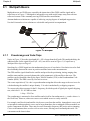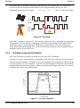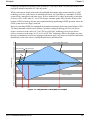
1
GPS+
Reference
Manual
OM-20000039 Rev 0I
Proprietary Notice
GPS+ Reference Manual
Publication Number:
Revision Level:
Revision Date:
OM-20000039
0I
2007/07/16
Proprietary Notice
No part of this manual may be reproduced or transmitted in any form or by any means, electronic or
mechanical, including photocopying and recording, for any purpose without the express written
permission of a duly authorized representative of NovAtel Inc.
The information contained within this manual is believed to be true and correct at the time of
publication.
NovAtel, MEDLL, Narrow Correlator tracking technology, ProPak, RT-20 and RT-2 are registered
trademarks of NovAtel Inc.
SPAN technology, EuroPak, GRAFNET/GRAFNAV, PAC, OEMV, and Waypoint are trademarks of
NovAtel Inc.
All other brand names are trademarks of their respective holders.
© Copyright 2000-2007 NovAtel Inc. All rights reserved. Unpublished rights reserved under
International copyright laws.
2
GPS+ Reference Manual Rev 0I
Table of Contents
Proprietary Notice
Customer Service
1 GPS Overview
2
8
9
1.1 GPS System Design ............................................................................................ 10
1.1.1 The Space Segment................................................................................... 10
1.1.2 The Control Segment ................................................................................. 10
1.1.3 The User Segment ..................................................................................... 10
1.2 Height Relationships ............................................................................................ 11
1.3 GPS Positioning................................................................................................... 12
1.3.1 Single-Point vs. Differential Positioning...................................................... 13
1.3.2 Static vs. Kinematic Positioning.................................................................. 15
1.3.3 Real-time vs. Post-mission Data Processing.............................................. 15
1.3.4 Performance Considerations ...................................................................... 15
2 SPAN Inertial Navigation Overview
3 Satellite-Based Augmentation System
19
20
3.1 SBAS Receiver .................................................................................................... 21
4 L-band Positioning
23
4.1 Coverage ............................................................................................................. 24
4.1.1 OmniSTAR Geographic Areas ................................................................... 24
4.1.2 Canada/America-Wide CDGPS.................................................................. 25
4.2 L-band Service Levels ......................................................................................... 27
4.2.1 Standard Service ........................................................................................ 27
4.2.2 High and Extra Performance Services ....................................................... 27
4.3 L-band Commands and Logs............................................................................... 28
5 GLONASS Overview
29
5.1 GLONASS System Design .................................................................................. 30
5.1.1 The Control Segment ................................................................................. 30
5.1.2 The Space Segment................................................................................... 30
5.1.3 The User Segment ..................................................................................... 30
5.2 Time ..................................................................................................................... 33
5.2.1 GPS Time vs. Local Receiver Time............................................................ 33
5.2.2 GLONASS Time vs. Local Receiver Time.................................................. 34
5.3 Datum .................................................................................................................. 34
6 Galileo
36
6.1 Overview .............................................................................................................. 36
6.1.1 Open Service.............................................................................................. 37
6.1.2 Commercial Service ................................................................................... 37
6.1.3 Safety-of-Life Service ................................................................................. 38
6.1.4 Public Regulated Service ........................................................................... 38
GPS+ Reference Manual Rev 0I
3
Table of Contents
6.1.5 Search and Rescue Service .......................................................................38
6.2 L1L5E5a Receiver ................................................................................................38
7 L2C Overview
39
7.1 Application Examples ...........................................................................................39
7.2 NovAtel’s GNSS Modernization ...........................................................................39
8 L5 Overview
9 Multipath
40
41
9.1 Multipath Basics ...................................................................................................42
9.1.1 Pseudorange and Code Chips....................................................................42
9.1.2 Tracking Loops and Correlators..................................................................43
9.2 Summary ..............................................................................................................46
10 TTFF and Satellite Acquisition
47
10.1 OEMV-based Products.......................................................................................47
10.2 SUPERSTAR II-based Products ........................................................................48
11 Standards/References
12 Unit Conversion
50
53
12.1 Distance .............................................................................................................53
12.2 Volume ...............................................................................................................53
12.3 Temperature .......................................................................................................53
12.4 Weight ................................................................................................................53
12.5 Hexadecimal, Binary and Decimal Equivalents ..................................................54
12.6 GPS Time Conversions ......................................................................................55
12.6.1 GPS Time of Week To Day of Week with Time of Day.............................55
12.6.2 Calendar Date to GPS Time .....................................................................55
13 Electrostatic Discharge Control (ESD) Practices
56
13.1 Overview ............................................................................................................56
13.2 Handling ESD-Sensitive Devices .......................................................................56
13.3 Prime Static Accumulators .................................................................................57
13.4 Handling Printed Circuit Boards .........................................................................58
14 Acronyms
15 Glossary
4
59
67
GPS+ Reference Manual Rev 0I
Figures
1
2
3
4
5
6
7
8
9
10
11
12
13
14
15
16
17
18
19
NAVSTAR Satellite Orbit Arrangement .............................................................................. 9
Illustration of Receiver Height Measurements ................................................................. 11
Accuracy versus Precision ............................................................................................... 12
The WGS84 ECEF Coordinate System ........................................................................... 13
Example Differential Positioning Setup ............................................................................ 14
SBAS and NovAtel ........................................................................................................... 20
The SBAS Concept .......................................................................................................... 22
L-band Concept ................................................................................................................ 23
CDGPS Frequency Beams .............................................................................................. 25
CDGPS Percentage (%) Coverage Map as of June 6, 2007 ........................................... 26
View of GPS and GLONASS Satellite Orbit Arrangement ............................................... 31
GPS and GLONASS L1 Frequencies .............................................................................. 32
GLONASS Antipodal Satellites ........................................................................................ 33
GNSS Signal Multipath vs. Increased Antenna Height .................................................... 41
Multipath ........................................................................................................................... 42
Time Delay ....................................................................................................................... 43
C/A Code Distortion ......................................................................................................... 43
Comparison of Correlator Patterns .................................................................................. 44
Comparison of Multipath Envelopes ................................................................................ 45
GPS+ Reference Manual Rev 0I
5
Tables
1
2
3
4
5
6
NovAtel GNSS Antenna Models ................................................................................ 15
Comparison of GLONASS and GPS Characteristics ................................................. 35
Typical Receiver TTFF for OEMV-Based Products ................................................... 47
Approximate Time and Position Methods .................................................................. 48
Static-Accumulating Materials.................................................................................... 57
GPS+ Reference Manual Rev 0I
GPS+ Reference Manual Rev 0I
7
Customer Service
Customer Service
Contact your local NovAtel dealer first for more information on products and services. To locate a
dealer in your area or if your question is not resolved, contact NovAtel Inc. directly using one of the
following methods:
Call the NovAtel Hotline at 1-800-NOVATEL (U.S. & Canada), or +1-403-295-4900 (international)
Fax: +1-403-295-4901
E-mail: [email protected]
Website: http://www.novatel.com
Write:
NovAtel Inc.
Customer Service Department
1120 - 68 Avenue NE
Calgary, AB
Canada, T2E 8S5
Try our Knowledge Base at http://www.novatel.com/support/knowledgedb.htm.
8
GPS+ Reference Manual Rev 0I
Chapter 1
GPS Overview
The Global Positioning System (GPS) is a satellite navigation system capable of providing a highly
accurate, continuous global navigation service independent of other positioning aids. GPS provides
24-hour, all-weather, worldwide coverage with position, velocity and timing information.
The system uses the NAVSTAR (NAVigation Satellite Timing And Ranging) satellites which consists
of 24 active satellites to provide a GPS receiver with at least six satellites in view at all times. A
minimum of four satellites in view are needed to allow the receiver to compute its current latitude,
longitude, altitude with reference to mean sea level and the GPS system time. As of 2007, there are 30
operational satellites.
At the time of publications, the current GPS constellation consists of 29 satellites and the most recent
(Block IIR-M) satellite was launched on September 26, 2005. The GPS constellation and individual
satellite status is updated every working day by NAVSTAR. See Chapter 11, Standards/References
starting on Page 50 for their contact information and a link to their website.
Figure 1: NAVSTAR Satellite Orbit Arrangement
NovAtel Application Notes on the topics covered in this reference manual, and many more, are
available from our website at http://www.novatel.com/support/applicationnotes.htm.
GPS+ Reference Manual Rev 0I
9
Chapter 1
1.1
GPS Overview
GPS System Design
The GPS system design consists of three parts:
•
The Space segment
•
The Control segment
•
The User segment
All these parts operate together to provide accurate three dimensional positioning, timing and velocity
data to users worldwide.
1.1.1
The Space Segment
The space segment is composed of the NAVSTAR GPS satellites. The constellation of the system
consists of 24 satellites in six 55° orbital planes, with four satellites in each plane (plus room for
spares). The orbit period of each satellite is approximately 12 hours at an altitude of 20 183
kilometers. This provides a GPS receiver with at least six satellites in view from any point on Earth, at
any particular time.
The GPS satellite signal identifies the satellite and provides the positioning, timing, ranging data,
satellite status and the corrected ephemerides (orbit parameters) of the satellite to the users. The
satellites can be identified either by the Space Vehicle Number (SVN) or the Pseudorandom Code
Number (PRN). The PRN is used by the NovAtel receiver.
The GPS satellites transmit on several L-band frequencies. L1 is centered at 1575.42 MHz, L2 at
1227.60 MHz and L5 at 1176.45 MHz. The L1 carrier is modulated by the C/A code (Coarse/
Acquisition) and the P-code (Precision) which is encrypted for military and other authorized users.
The L2 carrier is modulated with the P-code and L2C (civilian) code beginning with the GPS IIR-M
satellites. Please see also Section 9.1 starting on Page 42, which includes a sub-section on code and
carrier.
1.1.2
The Control Segment
The control segment consists of a master control station, five base stations and three data up-loading
stations in locations all around the globe.
The base stations track and monitor the satellites via their broadcast signals. The broadcast signals
contain the ephemeris data of the satellites, the ranging signals, the clock data and the almanac data.
These signals are passed to the master control station where the ephemerides are re-computed. The
resulting ephemerides corrections and timing corrections are transmitted back to the satellites via the
data up-loading stations.
1.1.3
The User Segment
The user segment, such as the NovAtel receiver, consists of equipment which tracks and receives the
satellite signals. The user equipment must be capable of simultaneously processing the signals from a
minimum of four satellites to obtain accurate position, velocity and timing measurements. The
NovAtel OEMV receiver can track 14 satellites, which can occur at high latitudes.
10
GPS+ Reference Manual Rev 0I
GPS Overview
1.2
Chapter 1
Height Relationships
What is a geoid?
An equipotential surface is any surface where gravity is constant. This surface best represents mean
sea level and not only covers the water but is projected throughout the continents. In North America
this surface is most commonly used at its zero value, that is, all heights are referenced to this surface.
What is an ellipsoid?
An ellipsoid, also known as a spheroid, is a mathematical surface which is sometimes used to
represent the Earth. Whenever you see latitudes and longitudes describing the location, this coordinate
is being referenced to a specific ellipsoid. GPS positions are referred to an ellipsoid known as WGS84
or WGS-84 (World Geodetic System of 1984).
What is the relationship between a geoid and an ellipsoid?
The relationship between a geoid and an ellipsoid is shown in Figure 2, Illustration of Receiver
Height Measurements on Page 11.
References:
1 Topography
2 Geoid (mean sea level)
3 Spheroid (ellipsoid)
H = Receiver computed height above/below geoid
N = Geoidal Height (undulation)
h = GPS system computed height above the spheroid
N=h-H
Figure 2: Illustration of Receiver Height Measurements
From the above diagram, and the formula h = H + N, to convert heights between the ellipsoid and
geoid we require the geoid-ellipsoid separation value. This value is not easy to determine. A worldwide model is generally used to provide these values. NovAtel GPS receivers store this value
internally. This model can also be augmented with local height and gravity information. A more
GPS+ Reference Manual Rev 0I
11
Chapter 1
GPS Overview
precise geoid model is available from government survey agencies for example, U.S. National
Geodetic Survey or Geodetic Survey of Canada (see Chapter 11, Standards/References starting on
Page 50).
Why is this important for GPS users?
The above formula is critical for GPS users as they typically obtain ellipsoid heights and need to
convert these into mean sea level heights. Once this conversion is complete, users can relate their GPS
derived heights to more “usable” mean sea level heights.
1.3
GPS Positioning
GPS positioning can be categorized as follows:
1.
single-point or differential
2.
static or kinematic
3.
real-time or post-mission data processing
A distinction should be made between accuracy and precision. Accuracy refers to how close an
estimate or measurement is to the true but unknown value; precision refers to how close an estimate is
to the mean (average) estimate. Figure 3 illustrates various relationships between these two
parameters: the true value is "located" at the intersection of the cross-hairs, the centre of the shaded
area is the "location" of the mean estimate, and the radius of the shaded area is a measure of the
uncertainty contained in the estimate.
Figure 3: Accuracy versus Precision1
1.
Environment Canada, 1993, Guideline for the Application of GPS Positioning, p. 22.
© Minister of Supply and Services Canada
12
GPS+ Reference Manual Rev 0I
GPS Overview
1.3.1
Chapter 1
Single-Point vs. Differential Positioning
In single-point positioning, coordinates of a GPS receiver at an unknown location are sought with
respect to the Earth's reference frame by using the known positions of GPS satellites being tracked.
The position solution generated by the receiver is initially developed in Earth-Centered-Earth-Fixed
(ECEF) coordinates which can subsequently be converted to any other coordinate system. See Figure
4 on Page 13 for a definition of the ECEF coordinates. With as few as four GPS satellites in view, the
absolute position of the receiver in three-dimensional space can be determined. Only one receiver is
needed.
- Definitions -
*
Origin = Earth's center of mass
Z-Axis =
Parallel to the direction of the Conventional Terrestrial Pole (CTP) for
polar motion, as defined by the Bureau International de l'Heure (BIH) on
the basis of the coordinates adopted for the BIH stations.
X -Axis =
Intersection of the WGS 84 Reference Meridian Plane and the plane of
the CTP's Equator, the Reference Meridian being parallel to the Zero
Meridian defined by the BIH on the basis of the coordinates adopted for
the BIH stations.
Y -Axis =
Completes a right-handed, earth-centered, earth-fixed (ECEF)
orthogonal coordinate system, measured in the plane of the CTP
Equator, 90¡ East of the X -Axis.
°
BIH - Defined CTP
(1984.0)
Z
WGS 84
ω
Earth's Center
of Mass
BIH-Defined
Zero Meridian
(1984.0)
Y
X
WGS 84
WGS 84
* Analogous to the BIH Defined Conventional Terrestrial System (CTS), or BT S,
1984.0.
Figure 4: The WGS84 ECEF Coordinate System
In differential positioning, also known as relative positioning, the coordinates of a GPS receiver at an
unknown point (the “rover” station) are sought with respect to a GPS receiver at a known point (the
“base” station). The concept is illustrated in Figure 5, Example Differential Positioning Setup on
Page 14. The differential-position accuracy of two receivers locked on the same satellites and not far
GPS+ Reference Manual Rev 0I
13
Chapter 1
GPS Overview
removed from each other - up to tens of kilometers - is extremely high. The largest error contributors
in single-point positioning are those associated with atmospheric-induced effects. These errors,
however, are highly correlated for adjacent receivers and hence cancel out in differential
measurements. Since the position of the base station can be determined to a high degree of accuracy
using conventional surveying techniques, any differences between its known position and the position
computed using GPS techniques can be attributed to various components of error as well as the
receiver’s clock bias. Once the estimated clock bias is removed, the remaining error on each
pseudorange can be determined. The base station sends information about each satellite to the rover
station, which in turn can determine its position much more exactly than would be possible otherwise.
The advantage of differential positioning is that much greater precision (presently as low as 2 mm,
depending on the method and environment) can be achieved than by single-point positioning. In order
for the observations of the base station to be integrated with those of the rover station, differential
positioning requires either a data link between the two stations (if the positioning is to be achieved in
real-time) or else post-processing of the data collected by the rover station. At least four GPS satellites
in view are still required. The absolute accuracy of the rover station’s computed position will depend
on the accuracy of the base station’s position.
Rover
Base
2
1
5
3
4
12V
Figure 5: Example Differential Positioning Setup
Reference
14
Description
1
A ProPak-V3 receiver for the rover station
2
User-supplied NovAtel GNSS antenna
3
User-supplied data storage device to COM1
4
User-supplied power supply
5
User-supplied radio device to COM2
6
A ProPak-V3 receiver for the base station
7
User-supplied laptop/PC, for setting up and monitoring, to COM1
GPS+ Reference Manual Rev 0I
GPS Overview
1.3.2
Chapter 1
Static vs. Kinematic Positioning
Static and kinematic positioning refer to whether a GPS receiver is stationary or in motion while
collecting GPS data. Refer to Chapter 5 of the OEMV Family Installation and Operation Manual for
more details on static and kinematic positioning. SUPERSTAR-II and OEM4-based product manuals
also contain a chapter on positioning modes of operation. Portable Document Format (PDF) manuals
are available from our website at http://www.novatel.com/support/docupdates.htm.
1.3.3
Real-time vs. Post-mission Data Processing
Real-time or post-mission data processing refer to whether the GPS data collected by the receiver is
processed as it is received or after the entire data-collection session is complete. Refer to Chapter 5 of
the OEMV Family Installation and Operation Manual set for more details on post-processed and realtime positioning.
OEMV-based output is compatible with post-processing software from the Waypoint Products Group,
NovAtel Inc. See also our website at www.novatel.com for details.
1.3.4
Performance Considerations
1.3.4.1
Antenna Selection
An active antenna is required because its Low-Noise Amplifier (LNA) boosts the power of the
incoming signal to compensate for the line loss between the antenna and the receiver.
NovAtel offers a variety of single and dual-frequency GNSS antenna models, as indicated in Table 1
below. All include band-pass filtering and an LNA. The GNSS antenna you choose will depend on
your particular application. Each of these models offer exceptional phase-center stability as well as a
significant measure of immunity against multipath interference. Each one has an environmentallysealed radome. The ANT-532, ANT-533, ANT-534, ANT-536, ANT-537, ANT-538, GPS-702L, GPS701GG and GPS-702GG are RoHS compliant.
Table 1: NovAtel GNSS Antenna Models
Models
Frequencies Supported
GPS
GLONASS
701, 511, 521, 536, 537
L1 only
9
8
702, 532, 533
L1 and L2
9
8
702L, 534
L1 and L2 plus L-band
9
8
701GGL, 538
L1 plus L-band
9
9
701GG
L1 only
9
9
702GGL
L1 and L2 plus L-band
9
9
702-GG
L1 and L2
9
9
GPS+ Reference Manual Rev 0I
15
Chapter 1
1.3.4.2
GPS Overview
Cable Length
An appropriate coaxial cable is one that is matched to the impedance of the antenna and receiver being
used (50 ohms), and whose line loss does not exceed 10.0 dB. If the limit is exceeded, excessive
signal degradation will occur and the receiver may not be able to meet its performance specifications.
NovAtel offers a variety of coaxial cables to meet your GPS antenna interconnection requirements.
Note that a conversion is required between the female MMCX connector on a bare OEMV card and
the female TNC connector on NovAtel’s GNSS antennas. Your local NovAtel dealer can advise you
about your specific configuration. If your application requires the use of cable longer than 30 m, refer
to the application note RF Equipment Selection and Installation on our website at http://
www.novatel.com/support/applicationnotes.htm, or you can obtain it directly from NovAtel Customer
Service.
High-quality coaxial cables should be used because a mismatch in impedance, possible with lower
quality cable, produces reflections in the cable that increase signal loss. Though it is possible to use
other high-quality antenna cables, the performance specifications of NovAtel receivers are warranted
only when used with NovAtel-supplied accessories.
1.3.4.3
GNSS System Errors
In general, GPS SPS C/A code single-point pseudorange positioning systems are capable of absolute
position accuracies of about 1.8 meters or less. This level of accuracy is really only an estimation, and
may vary widely depending on numerous GNSS system biases, environmental conditions, as well as
the GNSS receiver design and engineering quality.
There are numerous factors which influence the single-point position accuracies of any GNSS code
receiving system. As the following list shows, a receiver’s performance can vary widely when under
the influences of these combined system and environmental biases.
• Ionospheric Delays
•
•
•
•
16
The Earth’s ionospheric layers cause varying degrees of GNSS signal
propagation delay. Ionization levels tend to be highest during daylight
hours causing propagation delay errors of up to 30 meters, whereas night
time levels are much lower and may be as low as 6 meters.
Tropospheric Delays The Earth’s tropospheric layer causes GNSS signal propagation delays.
The amount of delay is at the minimum (about three metres) for satellite
signals arriving from 90 degrees above the horizon (overhead), and
progressively increases as the angle above the horizon is reduced to zero
where delay errors may be as much as 50 metres at the horizon.
Ephemeris Errors
Some degree of error always exists between the broadcast ephemeris’
predicted satellite position and the actual orbit position of the satellites.
These errors directly affect the accuracy of the range measurement.
Satellite Clock Errors Some degree of error also exists between the actual satellite clock time
and the clock time predicted by the broadcast data. This broadcast time
error causes some bias to the pseudorange measurements.
Receiver Clock Errors Receiver clock error is the time difference between GPS receiver time and
true GPS Time. All GNSS receivers have differing clock offsets from
GPS Time that vary from receiver to receiver by an unknown amount
depending on the oscillator type and quality (TCXO versus OCXO, and
GPS+ Reference Manual Rev 0I
GPS Overview
Chapter 1
• Multipath
1.3.4.4
so on). However, because a receiver makes all of its single-point
pseudorange measurements using the same common clock oscillator, all
measurements are equally offset, and this offset can generally be modeled
or quite accurately estimated to effectively cancel the receiver clock offset
bias. Thus, in single-point positioning, receiver clock offset is not a
significant problem.
Multipath signal reception can potentially cause large pseudorange and
carrier phase measurement biases. Multipath conditions are very much a
function of specific antenna site location versus local geography and manmade structural influences. Severe multipath conditions could skew range
measurements by as much as 100 meters or more. See also Chapter 9,
Multipath starting on Page 41.
RTK
When referring to the “performance” of RTK software, two factors are introduced: baseline length and
convergence time.
Baseline Length
Baseline length: the position estimate becomes less precise as the baseline length increases. Note that
the baseline length is the distance between the phase centres of the two antennas. Identifying the exact
position of your antenna’s phase centre is essential; this information is typically supplied by the
antenna’s manufacturer or vendor.
The RTK software automatically makes the transition between short and longer baselines, but the best
results are obtained for baselines less than 10 km. The following are factors which are related to
baseline length:
• ephemeris errors
• ionospheric effects
• tropospheric effects
These produce typical position errors of 0.75 cm per 10 km of baseline
length.
The dominant error for single-frequency GPS receivers on baselines
exceeding 10 km. Differential ionospheric effects reach their peak at
around 2 pm local time, being at a minimum during hours of darkness.
Ionospheric effects can be estimated and removed on dual-frequency GPS
receivers, greatly increasing the permissible baseline length, but at the
cost of introducing additional “noise” to the solution. Therefore, this type
of compensation is only used in cases where the ionospheric error is much
larger than the noise and multipath error.
These produce typical position errors of approximately 1 cm per 10 km of
baseline length. This error increases if there is a significant height
difference between the base and rover stations, as well as if there are
significantly different weather conditions between the two sites.
A related issue is that of multipath interference, the dominant error on short differential baselines.
Generally, multipath can be reduced by choosing the antenna’s location with care, and by the use of a
GPS-700 family antenna (no need for a choke ring) or a L1/L2 antenna and a choke ring antenna
ground plane. See also Table 1 on Page 15 and Chapter 9, Multipath starting on Page 41.
GPS+ Reference Manual Rev 0I
17
Chapter 1
GPS Overview
Convergence Time
The position estimate becomes more accurate and more precise with time. However, convergence
time is dependent upon baseline length: while good results are available after a minute or so for short
baselines, the time required increases with baseline length. Convergence time is also affected by the
number of satellites which can be used in the solution (the more satellites, the faster the convergence)
and by the errors listed in Baseline Length above.
18
GPS+ Reference Manual Rev 0I
Chapter 2
SPAN Inertial Navigation Overview
GPS positioning observes range measurements from orbiting Global Positioning System Satellites.
From these observations, the receiver can compute position and velocity with high accuracy. NovAtel
GPS positioning systems have been established as highly accurate positioning tools, however GPS in
general has some significant restrictions, which limit its usefulness in some situations. Accurate GPS
positioning requires line of site view to at least four satellites simultaneously. If these criteria are met,
differential GPS positioning can be accurate to within a few centimetres. If however, some or all of
the satellite signals are blocked, the accuracy of the position reported by GPS degrades substantially,
or may not be available at all.
In general, an Inertial Navigation System (INS) uses forces and rotations measured by an IMU to
calculate acceleration, velocity and attitude. This capability is embedded in the firmware of our plus
and OEMV series of receivers. Forces are measured by accelerometers in three perpendicular axes
within the IMU and the gyros measure rotations around those axes. Over short periods of time, inertial
navigation gives very accurate acceleration, velocity and attitude output. Since the IMU sensor
measures changes in orientation and acceleration, the INS determines changes in position and attitude.
The IMU must have prior knowledge of its initial position, initial velocity, initial attitude, Earth
rotation rate and gravity field. Once these parameters are known, an INS is capable of providing an
autonomous solution with no external inputs. However, because of errors in the IMU sensor
measurements that accumulate over time, an inertial-only solution will degrade with time unless
external updates such as position, velocity or attitude are supplied.
NovAtel’s SPAN system’s combined GPS/INS solution integrates the raw inertial measurements with
all available GPS solution and raw measurement information to provide the optimum solution
possible in any situation. By using the high accuracy of the GPS solution, the INS measurement errors
can be modeled and mitigated. Conversely, the continuity and relative accuracy of the INS solution
enables faster GPS signal re-acquisition and RTK solution convergence.
The advantages of using SPAN technology are its ability to:
•
Provide a full attitude solution (roll, pitch and azimuth)
•
Provide continuous solution output (in situations when a GPS-only solution is impossible)
•
Provide faster signal re-acquisition and RTK solution resolution (over stand-alone GPS
because of the tightly integrated GPS and IMU observations)
•
Output high-rate (up to 100 Hz) position, velocity and attitude solutions for high-dynamic
applications
•
Use raw phase observation data (to constrain INS solution drift even when too few satellites
are available for a full GPS solution)
Refer to the SPAN Technology User Manual available from our website at:
http://www.novatel.com/support/docupdates.htm.
GPS+ Reference Manual Rev 0I
19
Chapter 3
Satellite-Based Augmentation System
A Satellite-Based Augmentation System (SBAS) is a type of geo-stationary satellite system that
improves the accuracy, integrity, and availability of the basic GPS signals. Accuracy is enhanced
through the use of wide area corrections for GPS satellite orbits and ionospheric errors. Integrity is
enhanced by the SBAS network quickly detecting satellite signal errors and sending alerts to receivers
to not use the failed satellite. Availability is improved by providing an additional ranging signal to
each SBAS geo-stationary satellite.
SBAS includes the Wide-Area Augmentation System (WAAS), the European Geo-Stationary
Navigation System (EGNOS), and the MTSAT Satellite-Based Augmentation System (MSAS). The
Chinese SNAS, Indian GAGAN and Australian GRAS systems are in progress. At the time of
publication, there are two WAAS satellites over the Pacific Ocean (PRN 135 and PRN 138), an
EGNOS satellite over the eastern Atlantic Ocean (PRN 120), an EGNOS satellite over the Indian
Ocean (PRN 126) and another EGNOS GEO satellite over the African mid-continent (PRN 124).
SBAS data is available from any of these satellites and more satellites will be available in the future.
Since July, 2003, WAAS has been certified for Class 1/ Class 2 civilian aircraft navigation.
Figure 6 1 shows the regions applicable to each SBAS system mentioned in the paragraph above and
how NovAtel is involved in each of them.
SBAS and NovAtel Worldwide
EGNOS:
Europe (2001-2002)
• 24 RIMS-C receivers
(Integrity Channel)
SNAS
China (2000-2002)
• 73 WAAS WRS receivers
MSAS:
Japan (1998-2003)
• 47 MSAS WRS receivers
• 6 NLES GUS receivers
• 4 UPC receivers
WAAS:
USA (1996-1999) 1st Generation
• 148 WRS receivers
• 21 GUS receivers
WAAS G-II Receivers
Technology Refresh (2004-2006)
• 160 WAAS G-II receivers
Geostationary Command &
Control Segment (2004-2007)
• 17 L1/L5 Signal Generators
• 19 L1/L5 GUS receivers
Key
Wide Area Master
Station
Wide Area Reference
or Earth Station
EGNOS RIMS Site
GAGAN:
India (2005)
• 18 WAAS G-II receivers
• 3 L1/L5 GUS receivers
• 3 L1/L5 Signal Generators
GRAS:
Australia (2007)
• 23 WAAS G-II receivers
Figure 6: SBAS and NovAtel
1.
20
Last updated in August, 2007.
GPS+ Reference Manual Rev 0I
Satellite-Based Augmentation System
Chapter 3
SBAS is made up of a series of Reference Stations, Master Stations, Ground Uplink Stations and Geostationary Satellites (GEOs), see Figure 7, The SBAS Concept on Page 22. The Reference Stations,
which are geographically distributed, pick up GPS satellite data and route it to the Master Stations
where wide area corrections are generated. These corrections are sent to the Ground Uplink Stations
which up-link them to the GEOs for re-transmission on the GPS L1 frequency. These GEOs transmit
signals which carry accuracy and integrity messages, and which also provide additional ranging
signals for added availability, continuity and accuracy. These GEO signals are available over a wide
area and can be received and processed by NovAtel receivers with appropriate firmware. GPS user
receivers are thus able to receive SBAS data in-band and use not only differential corrections, but also
integrity, residual errors and ionospheric information for each monitored satellite.
The signal broadcast via the SBAS GEOs to the SBAS users is designed to minimize modifications to
standard GPS receivers. As such, the GPS L1 frequency (1575.42 MHz) is used, together with GPStype modulation, for example, a Coarse/Acquisition (C/A) pseudorandom (PRN) code. In addition,
the code phase timing is maintained close to GPS Time to provide a ranging capability.
The primary functions of SBAS include:
• data collection
• determining ionospheric corrections
• determining satellite orbits
• determining satellite clock corrections
• determining satellite integrity
• independent data verification
• SBAS message broadcast and ranging
• system operations & maintenance
3.1
SBAS Receiver
All OEMV models, many OEM4 and several SSII models of NovAtel receivers are equipped with
SBAS capability. The ability to incorporate the SBAS corrections into the position is available in
these models.
SBAS data can be output in log format and can incorporate these corrections to generate differentialquality position solutions. Standard SBAS data messages are analyzed based on RTCA standards for
GPS/WAAS airborne equipment. Please refer to your SUPERSTAR II Firmware Reference Manual or
OEMV Firmware Reference Manual for details on SBAS commands and logs.
An SBAS-capable receiver permits anyone within the area of coverage to take advantage of its
benefits with no subscription fee.
GPS+ Reference Manual Rev 0I
21
Chapter 3
Satellite-Based Augmentation System
1
2
3
5
4
6
8
9
9
7
11
9
7
10
Figure 7: The SBAS Concept
Reference
22
Description
Reference
Description
1
Geo-stationary Satellite (GEO)
8
C-Band
2
GPS Satellite Constellation
9
SBAS Reference Station
3
L1
10
SBAS Master Station
4
L1 and C-Band
11
Ground Uplink Station
5
L1 and L2
6
GPS User
7
Integrity data, differential
corrections and ranging control
GPS+ Reference Manual Rev 0I
Chapter 4
L-band Positioning
The transmission of OmniSTAR or Canada-Wide Differential Global Positioning System (CDGPS)
corrections are from geo-stationary satellites. The L-band frequency of these geo-stationary satellites
is sufficiently close to that of GPS that a common, single antenna, such as the NovAtel 702L, may be
used.
Both systems are portable and capable of sub-meter accuracy over their coverage areas. See Figure 8.
6
1
1
7
5
4
3
8
2
3
2
3
2
Figure 8: L-band Concept
Reference
1
2
3
4
5
6
7
8
Description
GPS satellites
Multiple L-band ground stations
Send GPS corrections to 4
Network Control Center where data corrections are checked and
repackaged for uplink to 6
DGPS uplink
L-band geo-stationary satellite
L-band DGPS signal
Correction data are received and applied real-time
GPS+ Reference Manual Rev 0I
23
Chapter 4
L-band Positioning
The OmniSTAR system is designed for coverage of most of the world’s land areas. A subscription
charge by geographic area is required. The CDGPS system is a free Canada-wide DGPS service that is
accessible coast-to-coast, throughout most of the continental United States, and into the Arctic.
By default the OEMV-1, OEMV-3 and ProPak-V3 models with L-band software support the standard
CDGPS sub-meter L1/L2 service and the OmniSTAR Virtual Base Station (VBS) sub-meter L1
service. The OmniSTAR VBS service is upgradeable on the OEMV-3 and ProPak-V3 to the Extra
Performance (XP) decimeter L1/L2 service or High Performance (HP) sub-decimeter L1/L2 service
via a coded message from an OmniSTAR satellite.
4.1
Coverage
The two systems provide different coverage areas:
4.1.1
•
OmniSTAR - Most of the World’s Land Areas
•
CDGPS - Canada/America-Wide
OmniSTAR Geographic Areas
In most world areas, a single satellite is used by OmniSTAR to provide coverage over an entire
continent - or at least very large geographic areas. In North America, a single satellite is used, but it
needs three separate beams to cover the continent. The three beams are arranged to cover the East,
Central, and Western portions of North America. The same data is broadcast over all three beams, but
the user system must select the proper beam frequency. The beams have overlaps of several hundred
miles, so the point where the frequency must be changed is not critical.
The L-band frequency can be changed using the ASSIGNLBAND command. Refer to the OEMV
Family Firmware Reference Manual or to Volume 2 of the OEM4 User Manual set.
The North American OmniSTAR Network currently consists of ten permanent base stations in the
Continental U.S., plus one in Mexico. These eleven stations track all GPS satellites above 5 degrees
elevation and compute corrections every 600 milliseconds. The corrections are sent to the OmniSTAR
Network Control Center (NCC) in Houston via wire networks. At the NCC these messages are
checked, compressed, and formed into packets for transmission up to the OmniSTAR satellite
transponder. This occurs approximately every few seconds. A packet will contain the latest
corrections from each of the North American base stations.
All of the eastern Canadian Provinces, the Caribbean Islands, Central America (south of Mexico), and
South America is covered by a single satellite (AM-Sat). A single subscription is available for all the
areas covered by this satellite.
OmniSTAR currently has several high-powered satellites in use around the world. They provide
coverage for most of the world's land areas. Subscriptions are sold by geographic area. Any Regional
OmniSTAR service center can sell and activate subscriptions for any area. They may be arranged prior
to travelling to a new area, or after arrival. Contact OmniSTAR at www.omnistar.com for further
details.1
1.
24
Please see Page 52 for more OmniSTAR contact information.
GPS+ Reference Manual Rev 0I
L-band Positioning
4.1.2
Chapter 4
Canada/America-Wide CDGPS
In order to enable CDGPS positioning, you must set the L-band frequency for the geographically
appropriate CDGPS signal using the ASSIGNLBAND command. Refer to the OEMV Family
Firmware Reference Manual or to Volume 2 of the OEM4 User Manual set.
The CDGPS signal is broadcast on 4 different spot beams on the MSAT-1 satellite. Depending on your
geographic location, there will be a different frequency for the CDGPS signal as shown in Figure 9.
Figure 9: CDGPS Frequency Beams
The following are the spot beam names and their frequencies (in KHz or Hz):
East
East-Central
West-Central
West
1547646 or 1547646000
1557897 or 1557897000
1557571 or 1557571000
1547547 or 1547547000
The CDGPS service does not include the MSAT Alaska/Hawaii beam shown in Figure 9.
The data signal is structured to perform well in difficult, or foliated conditions, so the service is
available more consistently than other services and has a high degree of service reliability.
CDGPS features wide area technology, possible spatial integrity with all Government of Canada maps
and surveys 1 2, 24-hour/7 days-a-week built-in network redundancies and an openly published
broadcast protocol.
1.
If the coordinates are output using the CSRS datum. Refer to the DATUM command in the
OEMV Family Firmware Reference Manual.
2.
The Geological Survey of Canada website is at http://gsc.nrcan.gc.ca/index_e.php.
GPS+ Reference Manual Rev 0I
25
Chapter 4
4.1.2.1
L-band Positioning
CDGPS Coverage
Figure 10, CDGPS Percentage (%) Coverage Map as of June 6, 2007 below is a conservative map of
the coverage areas that CDGPS1 guarantees. The coverage may be better in your area.
Figure 10: CDGPS Percentage (%) Coverage Map as of June 6, 2007
In Figure 10, 100% coverage means that a correction is received for every visible satellite (at or above
10 degrees). 90% coverage means that a correction is received for 90% of visible satellites. For
example, if a user views 10 satellites but has 90% coverage then there are no corrections available for
one of the satellites. In that case, our firmware shows that a correction is missing for that SV and
excludes it from the position calculation.
4.1.2.2
Performance
For the OEMV Family, CDGPS position accuracy is 0.7 m circular error probable (CEP)2. Refer also
to the Performance section of the Technical Specifications appendix in the OEMV Family Installation
and Operation User Manual.
26
1.
Please see Page 52 for CDGPS contact information.
2.
CEP: The radius of a circle such that 50% of a set of events occur inside the boundary.
GPS+ Reference Manual Rev 0I
L-band Positioning
4.2
Chapter 4
L-band Service Levels
Two levels of service are available:
Standard
-
Extra Performance High Performance
4.2.1
-
Sub-meter accuracy from OmniSTAR
VBS (subscription required) and CDGPS
Decimeter accuracy from OmniSTAR XP
(subscription required)
Sub-decimeter accuracy from OmniSTAR
HP (subscription required)
Standard Service
The OmniSTAR VBS service uses multiple GPS base stations in a solution and reduces errors due to
the GPS signals travelling through the atmosphere. It uses a wide area DGPS solution (WADGPS) and
data from a relatively small number of base stations to provide consistent accuracy over large areas. A
unique method of solving for atmospheric delays and weighting of distant base stations achieves submeter capability over the entire coverage area - regardless of your location relative to any base station.
CDGPS is able to simultaneously track two satellites, and incorporate the corrections into the
position. The output is SBAS-like (see WAAS32-WAAS45 in the OEMV Family Firmware Reference
Manual), and can incorporate these corrections to generate differential-quality position solutions.
CDGPS allows anyone within the area of coverage to take advantage of its benefits.
CDGPS and OmniSTAR VBS services are available on OEMV-1 and OEMV-3-based products.
NovAtel’s ProPak-V3 provides GPS with L-band corrections in one unit, using a common antenna.
This means that, with CDGPS or a subscription to the OmniSTAR VBS service, the ProPak-V3 is a
high quality receiver with sub-meter capabilities.
The position from the GPSCard in the receiver is used as the L-band system’s first approximation.
After the L-band processor has taken care of the atmospheric corrections, it then uses its location
versus the base station locations, in an inverse distance-weighted least-squares solution. L-band
technology generates corrections optimized for the location. It is this technique that enables the Lband receiver to operate independently and consistently over the entire coverage area without regard
to where it is in relation to the base stations.
4.2.2
High and Extra Performance Services
The OEMV-3 or ProPak-V3 with OmniSTAR High Performance (HP) service gives you more
accuracy than the OmniSTAR VBS or CDGPS services. OmniSTAR HP computes corrections in
dual-frequency RTK float mode (within about 10 cm accuracy). The XP service is similar to HP but
less accurate (15 cm) and more accurate than VBS (1 m). HP uses reference stations while XP uses
clock model data from NASA’s Jet Propulsion Laboratory (JPL). To obtain these corrections, your
receiver must have an HP or XP subscription from OmniSTAR, visit www.omnistar.com for details.
1.
2.
For optimal performance, allow the OmniSTAR HP or XP solution to converge prior to
starting any dynamic operation.
OmniSTAR XP is now available over a wider coverage area.
GPS+ Reference Manual Rev 0I
27
Chapter 4
4.3
L-band Positioning
L-band Commands and Logs
The ASSIGNLBAND command allows you to set OmniSTAR or CDGPS base station
communication parameters. It should include relevant frequency and data rate, for example:
assignlband omnistar 1536782 1200
or,
assignlband cdgps 1547547 4800
The PSRDIFFSOURCE command lets you identify from which source to accept RTCA1, RTCM1,
CDGPS or OmniSTAR VBS differential corrections. For example, in the PSRDIFFSOURCE
command, OMNISTAR enables OmniSTAR VBS and disables other DGPS types. AUTO means the
first received RTCM or RTCA message has preference over an OmniSTAR VBS or CDGPS message.
The RTKSOURCE command lets you identify from which source to accept RTK (RTCM, RTCMV3,
RTCA, CMR, CMRPLUS and OmniSTAR HP or XP) differential corrections. For example, in the
RTKSOURCE command, OMNISTAR enables OmniSTAR HP or XP, if allowed, and disables other
RTK types. AUTO means the NovAtel RTK filter is enabled and the first received RTCM, RTCA or
CMR message is selected and the OmniSTAR HP or XP message, if allowed, is enabled. The position
with the best standard deviation is used in the BESTPOS log.
The HPSEED command allows you to specify the initial position for OmniSTAR HP.
The HPSTATICINIT command allows you to speed up the convergence time of the HP or XP process
when you are not moving.
The PSRDIFFSOURCE and RTKSOURCE commands are useful when the receiver is receiving
corrections from multiple sources.
Several L-band specific logs also exist and are prefixed by the letters RAWLBAND, LBAND or
OMNI. CDGPS corrections are output similarly to SBAS corrections. There are four SBAS fast
corrections logs (WAAS32-WAAS35) and one slow corrections log (WAAS45) for CDGPS. The
CDGPS PRN is 209.
1.
2.
In addition to a NovAtel receiver with L-band capability, a subscription to the
OmniSTAR, or use of the free CDGPS, service is required.
All PSRDIFFSOURCE entries fall back to SBAS (even NONE) for backwards
compatibility.
Refer to the OEMV Family Firmware Reference Manual for more details on individual L-band
commands and logs.
28
GPS+ Reference Manual Rev 0I
Chapter 5
GLONASS Overview
The OEMV-1G-based, OEMV-2-based, and OEMV-3-based products are GLONASS-enabled with
full code and carrier phase (RTK) positioning, as well as the ability to record raw GPS and GLONASS
measurements. We discuss these capabilities further in this overview.1
RTK performs significantly better when tracking both GPS and GLONASS satellites, than when
tracking GPS satellites only. Adding GLONASS to GPS improves all aspects of satellite navigation
and RTK operation (availability, reliability, stability, time of RTK initialization, and so on).
The use of GLONASS in addition to GPS provides very significant advantages:
•
increased satellite signal observations
•
markedly increased spatial distribution of visible satellites
•
reduced Horizontal and Vertical Dilution of Precision factors
•
decreased occupation times means faster RTK results
In order to determine a position in GPS-only mode the receiver must track a minimum of four
satellites, representing the four unknowns of 3-D position and time. In combined GPS/GLONASS
mode, the receiver must track five satellites, representing the same four previous unknowns and at
least one GLONASS satellite to determine the GPS/GLONASS time offset.
With the availability of combined GPS/GLONASS receivers, users have access to a potential 48+
satellite-combined system. With 48+ satellites, performance in urban canyons and other locations with
restricted visibility, such as forested areas improves as more satellites are visible in the non-blocked
portions of the sky. A larger satellite constellation also improves real-time carrier phase differential
positioning performance.
Russia has committed itself to bringing the system up to the required minimum of 18 active satellites
by the end of 2007, and signed an agreement with India that provides for the launches of GLONASS
satellites on Indian launch vehicles. At the time of publication, April 2007, there are 12 operational
GLONASS satellites and one newly launched GLONASS satellite at its commissioning phase. The
Russian Government have set 2009 as the full deployment date of the 24-satellite constellation and
ensured financial support to meet that date.2
The OEMV-2 and OEMV-3 receivers acquire and track GPS and GLONASS signals. Combined GPS
and GLONASS measurements allow both real-time and post-processing GNSS applications. OEMVbased output is compatible with GrafNav post-processing software from NovAtel’s Waypoint
Products Group. Visit our website at http://www.novatel.com/products/waypoint_pps.htm for details.
1. This GLONASS Overview section was originated, and reviewed, with contributions from
Professor Richard B. Langley, Geodetic Research Laboratory, Department of Geodesy and
Geomatics Engineering, University of New Brunswick, Fredericton, N.B., Canada E3B 5A3;
http://www.unb.ca/GGE/
2. Refer to the Russian Space Agency's website at http://www.glonass-ianc.rsa.ru
GPS+ Reference Manual Rev 0I
29
Chapter 5
5.1
GLONASS Overview
GLONASS System Design
As with GPS, the GLONASS system uses a satellite constellation to provide, ideally, a GLONASS
receiver with six to twelve satellites at most times. A minimum of four satellites in view allows a
GLONASS receiver to compute its position in three dimensions, as well as become synchronized to
the system time.
The GLONASS system design consists of three parts:
•
The Control segment
•
The Space segment
•
The User segment
All these parts operate together to provide accurate three-dimensional positioning, timing and velocity
data to users worldwide.
5.1.1
The Control Segment
The Control Segment consists of the system control center and a network of command tracking
stations across Russia. The GLONASS control segment, similar to GPS, must monitor the status of
satellites, determine the ephemerides and satellite clock offsets with respect to GLONASS time and
UTC (Coordinated Universal Time), and twice a day upload the navigation data to the satellites.
5.1.2
The Space Segment
The Space Segment is the portion of the GLONASS system that is located in space, that is, the
GLONASS satellites that provide GLONASS ranging information. When complete, this segment will
consist of 24 satellites in three orbital planes, with eight satellites per plane. Figure 11, View of GPS
and GLONASS Satellite Orbit Arrangement on Page 31 shows a combined GPS and GLONASS
satellite system.
5.1.3
The User Segment
The User Segment consists of equipment (such as a NovAtel OEMV family receiver) that tracks and
receives the satellite signals. This equipment must be capable of simultaneously processing the signals
from a minimum of four satellites to obtain accurate position, velocity and timing measurements. Like
GPS, GLONASS is a dual military/civilian-use system. The system’s potential civil applications are
many and mirror those of GPS.
30
GPS+ Reference Manual Rev 0I
GLONASS Overview
Chapter 5
Figure 11: View of GPS and GLONASS Satellite Orbit Arrangement
Following are points about the GLONASS space segment:
•
The geometry repeats about once every 8 days. The orbit period of each satellite is approximately
8/17 of a sidereal day such that, after eight sidereal days, the GLONASS satellites have
completed exactly 17 orbital revolutions. A sidereal day is the rotation period of the Earth relative
to the equinox and is equal to one calendar day (the mean solar day) minus approximately four
minutes.
•
Because each orbital plane contains eight equally spaced satellites, one of the satellites will be at
the same spot in the sky at the same sidereal time each day.
•
The satellites are placed into nominally circular orbits with target inclinations of 64.8 degrees and
an orbital height of about 19,140 km, which is about 1,050 km lower than GPS satellites.
•
The GLONASS satellite signal identifies the satellite and provides:
•
the positioning, velocity and acceleration vectors at a reference epoch for computing
satellite locations
•
synchronization bits
•
data age
•
satellite health
•
offset of GLONASS time from UTC (SU) (formerly Soviet Union and now Russia)
•
almanacs of all other GLONASS satellites
•
Some of the GLONASS transmissions initially caused interference to radio astronomers and
mobile communication service providers. The Russians consequently agreed to reduce the
number of frequencies used by the satellites and to gradually change the L1 frequencies in the
future to 1598.0625 - 1605.375 MHz. Eventually the system will only use 12 primary frequency
channels (plus two additional channels for testing purposes).
GPS+ Reference Manual Rev 0I
31
Chapter 5
5.1.3.1
GLONASS Overview
GPS and GLONASS Satellite Identification
The GLONASS satellites each transmit on slightly different L1 and L2 frequencies, with P- code on
both L1 and L2, and with C/A code, at present, only on L1. GLONASS-M satellites reportedly1
transmit the C/A code on L2.
Every GPS satellite transmits the L1 frequency centered at 1575.42 MHz. The GPS satellites are
identifiable by their Pseudorandom Code Number (PRN) with a NovAtel receiver.
Unlike GPS, all GLONASS satellites transmit the same code at different frequencies. They derive
signal timing and frequencies from one of three on-board cesium atomic clocks operating at 5 MHz:
For example,
L1 = 1602 MHz + (n x 0.5625) MHz
where
n = the frequency channel number (n = 0, 1, 2 and so on)
It means that satellites transmits signals on their own frequency, separated by multiples of 0.5625
MHz or 562.5 kHz, from the frequency of other satellites. See also Figure 12 below.
All GPS satellites use
an L1 frequency
centered at
1575.42 Mhz
n=1
L1 = 1602.5625
n=5
L1 = 1604.8125
n = 10
L1 = 1607.625
MHz
GLONASS satellites each have a unique or an antipodal frequency
For GLONASS L1: L1 = 1602 MHZ + (n x 0.5625) MHz
Figure 12: GPS and GLONASS L1 Frequencies
The signals are right-hand circularly polarized, like GPS signals, and have comparable signal strength.
GLONASS accomplishes system operation (24 satellites and only 12 channels) by having antipodal
satellites transmit on the same frequency. Antipodal satellites are in the same orbit plane separated by
180 degrees in argument of latitude. This is possible because the paired satellites will never appear at
the same time in view of an operational receiver that is on the Earth’s surface, see Figure 13,
GLONASS Antipodal Satellites on Page 33. At the time of publication, April 2007, four pairs of
operational satellites share frequencies.
1. Refer to the GLONASS Interface Control Document (ICD), Version 5.0, Moscow, 2002 for
more details. You can find GLONASS contact information on Page 51.
32
GPS+ Reference Manual Rev 0I
GLONASS Overview
Chapter 5
Figure 13: GLONASS Antipodal Satellites
A comparison of GPS with GLONASS satellites, signals and messages is in Table 2 on Page 35.
5.2
Time
As stated earlier, both GPS and GLONASS satellites broadcast their time within their satellite
messages. NovAtel’s OEMV family of receivers are able to receive and record both time references as
well as report the offset information between GPS and GLONASS time. Although similar, GPS and
GLONASS have several differences in the way they record and report time. Please see the following
sections for information on GPS and GLONASS time, as well as on how NovAtel’s OEMV receivers
are GPS week rollover compliant.
5.2.1
GPS Time vs. Local Receiver Time
All logs output by the receiver report GPS Time expressed in GPS weeks and seconds into the week.
The time reported is not corrected for local receiver clock error. To derive the closest GPS Time, you
must subtract the clock offset shown in the TIME log from GPS Time reported, refer to the OEMV
Family Firmware Reference Manual1.
1. NovAtel User Manuals are available from our website at:
http://www.novatel.com/support/docupdates.htm.
GPS+ Reference Manual Rev 0I
33
Chapter 5
GLONASS Overview
GPS Time is based on an atomic time scale. Coordinated Universal Time as maintained by the U.S.
Naval Observatory (UTC (USNO) reported in NMEA logs) is also based on an atomic time scale,
with an offset of an integer number of seconds with respect to GPS Time. GPS Time is designated as
being coincident with UTC (USNO) at the start date of January 6, 1980 (00 hours). GPS Time does
not count leap seconds, and therefore an offset exists between UTC (USNO) and GPS Time (at this
date in April 2007: 14 seconds). The GPS week consists of 604800 seconds, where 000000 seconds is
at Saturday/Sunday midnight GPS Time. Each week at this time, the week number increments by one,
and the seconds into the week resets to 0.
5.2.2
GLONASS Time vs. Local Receiver Time
GLONASS time is based on an atomic time scale similar to GPS. This time scale is UTC as
maintained by Russia (UTC (SU)).
Unlike GPS, the GLONASS time scale is not continuous and must be adjusted for periodic leap
seconds. Leap seconds are applied to all UTC time references as specified by the International Earth
Rotation and Reference System Service (IERS). Leap seconds are used to keep UTC close to mean
solar time. Mean solar time, based on the spin of the Earth on its axis, is not uniform and its rate is
gradually changing due to tidal friction and other factors such as motions of the Earth's fluid core.
GLONASS time is maintained within 1 ms, and typically better than 1 microsecond (μs), of UTC
(SU) by the control segment with the remaining portion of the offset broadcast in the navigation
message. As well, Moscow offsets GLONASS time from UTC (SU) by plus three hours. The
GLOCLOCK log, refer to the OEMV Family Firmware Reference Manual, contains the offset
information between GPS and GLONASS time.
5.3
Datum
A datum is a set of parameters (translations, rotations, and scale) used to establish the position of a
reference ellipsoid with respect to points on the Earth’s crust. If not set, the receiver’s factory default
value is the World Geodetic System 1984 (WGS84).
GLONASS information is referenced to the Parametri Zemli 1990 (PZ-90, or in English translation,
Parameters of the Earth 1990, PE-90) geodetic datum, and GLONASS coordinates are reconciled in
the receiver through a position filter and output to WGS84.
See also the DATUM command in the OEMV Family Firmware Reference Manual, available in PDF
format from our website at http://www.novatel.com/support/docupdates.htm.
34
GPS+ Reference Manual Rev 0I
GLONASS Overview
Chapter 5
Table 2: Comparison of GLONASS and GPS Characteristics
Parameter
Satellites
Signals
Detail
GLONASS
GPS
Number of satellites
21 + 3 spares
Number of orbital planes
3
6
Orbital plane inclination (degrees)
64.8
55
Orbital radius (kilometers)
25 510
26 560
5.0
10.23
FDMA
CDMA
1598.0625 - 1609.3125c
1575.42
L2
1242.9375 - 1251.6875
1227.6
C/A
0.511
1.023
P
5.11
10.23
C/A
511
1 023
P
5.11 x 10⁶
6.187104 x 10¹²
Fundamental clock frequency (MHz)
Signal separation technique
b
Carrier frequencies (MHz) L1
Code clock rate (MHz)
Code length (chips)
a
21 + 3 spares a
C/A-code Navigation
Superframe duration (minutes)
2.5
12.5
Message
Superframe capacity (bits)
7 500
37 500
Superframe reserve capacity (bits)
~620
~2 750
Word duration (seconds)
2.0
0.6
Word capacity (bits)
100
30
Number of words within a frame
15
50
Technique for specifying satellite
ephemeris
Geocentric Cartesian
coordinates and their
derivatives
Keplarian orbital
elements and
perturbation factors
Time reference d
UTC (SU)
UTC (USNO)
Position reference (geodetic datum) e
PZ-90
WGS84
a. At the time of publication, April 2007, there are 29 operational GPS satellites and 12 operational GLONASS
satellites in orbit.
b. Full GLONASS system operation will consist of 24 satellites and only 12 channels. Such a system of
simultaneous multiple transmissions is known as frequency division multiple access (FDMA) and
distinguishes GLONASS from GPS, which is a code division multiple access (CDMA) system. See also
Section 5.1.3.1, GPS and GLONASS Satellite Identification starting on Page 32.
c. Refer to the GLONASS Interface Control Document (ICD), Version 5.0, Moscow, 2002 for more details. You
can find GLONASS contact information on Page 51.
d. GLONASS and GPS use different time systems. GLONASS time is referenced to UTC (SU), the Russian
National Etalon time scale, whereas, GPS Time is referenced to UTC as maintained by the U.S. Naval
Observatory – UTC (USNO). The GLONASS control segment periodically applies a time step to bring the
system’s time within several hundred nanoseconds of UTC.
e. GLONASS ephemerides are referenced to the Parametry Zemli 1990 (PZ-90, or in English translation,
Parameters of the Earth 1990, PE-90) reference frame. The realization of the PZ-90 frame through adopted
reference station coordinates has resulted in offsets in origin and orientation as well as a difference in scale
with respect to WGS84 used by GPS. Relationships between PZ-90 and WGS84 have now been
established.
GPS+ Reference Manual Rev 0I
35
Chapter 6
Galileo
This chapter is intended to give you information on the Galileo1 signals and their use.
6.1
Overview
Galileo will be Europe's own global navigation satellite system, providing a highly accurate,
guaranteed global positioning service under civilian control. It will be inter-operable with GPS and
GLONASS, the two other global satellite navigation systems.
A user will be able to take a position with the same receiver from any of the satellites in any
combination. By offering dual frequencies as standard, however, Galileo will deliver real-time
positioning accuracy down to the metre range, which is unprecedented for a publicly available system.
It will guarantee availability of the service under all but the most extreme circumstances and will
inform users within seconds of a failure of any satellite. This will make it suitable for applications
where safety is crucial, such as running trains, guiding cars and landing aircraft.
The first experimental satellite, part of the so-called Galileo System Test Bed (GSTB) was launched in
the second semester of 2005. The objective of this experimental satellite is to characterize the critical
technologies, which are already in development under European Space Agency (ESA) contracts.
Thereafter up to four operational satellites will be launched in the 2007-2008 time frame to validate
the basic Galileo space and related ground segment. Once this In-Orbit Validation (IOV) phase has
been completed, the remaining satellites will be installed to reach the Full Operational Capability
(FOC) in 2010.
The fully deployed Galileo system consists of 30 satellites (27 operational + 3 active spares),
positioned in three circular Medium Earth Orbit (MEO) planes in 23616 km altitude above the Earth,
and at an inclination of the orbital planes of 56 degrees with reference to the equatorial plane. Once
this is achieved, the Galileo navigation signals will provide a good coverage even at latitudes up to 75
degrees north, which corresponds to the North Cape, and beyond. The large number of satellites
together with the optimisation of the constellation, and the availability of the three active spare
satellites, will ensure that the loss of one satellite has no discernible effect on the user.
Two Galileo Control Centres (GCC) will be implemented on European ground to provide for the
control of the satellites and to perform the navigation mission management. The data provided by a
global network of twenty Galileo Sensor Stations (GSS) will be sent to the Galileo Control Centres
through a redundant communications network. The GCC's will use the data of the Sensor Stations to
compute the integrity information and to synchronize the time signal of all satellites and of the ground
station clocks. The exchange of the data between the Control Centres and the satellites will be
performed through so-called up-link stations. Five S-band up-link stations and 10 C-band up-link
stations will be installed around the globe for this purpose.
As a further feature, Galileo will provide a global Search and Rescue (SAR) function, based on the
operational search and rescue satellite aided tracking Cospas-Sarsat system. To do so, each satellite
1. Galileo Overview information from ESA Navigation website http://www.esa.int/esaCP/index.html
36
GPS+ Reference Manual Rev 0I
Galileo
Chapter 6
will be equipped with a transponder, which is able to transfer the distress signals from the user
transmitters to the Rescue Co-ordination Centre (RCC), which will then initiate the rescue operation.
At the same time, the system will provide a signal to the user, informing them that their situation has
been detected and that help is under way. This latter feature is new and is considered a major upgrade
compared to the existing system, which does not provide a feedback to the user.
Five categories of services have been defined:
6.1.1
1.
A free Open Service (OS)
2.
A highly reliable Commercial Service (CS)
3.
A Safety-of-Life Service (SOL)
4.
A government encrypted Public Regulated Service (PRS)
5.
A Search and Rescue Service (SAR)
Open Service
This single-frequency service will involve the provision of a positioning, navigation and precise
timing service. It will be available for use by any person in possession of a Galileo receiver. No
authorisation will be required to access this service. Galileo is expected to be similar to GPS in this
respect.
The principal applications will be general navigation and positioning, network timing, traffic
information systems, systems including information on alternative routes in the event of congestion,
and wireless location, for example, with mobile telephony.
Studies clearly show that the availability of these services will be significantly enhanced by the
existence of a greater number of satellites, as is the case when both GPS and Galileo are in operation.
This is particularly important for land-based services, such as private car navigation, where service is
mostly required in down town cores and where satellite shadowing is minimised by the combination
of the systems.
The Open Service will be transmitted in the E5a frequency band at 1176.45 MHz.
6.1.2
Commercial Service
Service providers using the multi-frequency commercial services will have the opportunity to give
added value to their range of products for which they can charge the end customer and will, in turn,
pay a fee to the Galileo operator. The signal will contain data relating to the additional commercial
services being offered. In return for the fee, the Galileo operator will be able to offer certain service
guarantees. This aspect of service guarantee and the commensurate liabilities is one area where
Galileo is significantly differentiated from GPS. A key component in achieving this is an independent
system within Galileo for monitoring the satisfactory working of the system and informing the end
user of this by an integrity signal incorporated in the data stream.
The main applications for this service concern professional users who are ready to pay for a service
guaranteed by the Galileo operator, notably in the areas of technical surveys, in activities involving
customs and excise operations, network synchronisation, sea fleet management, vehicle fleet
management, and road tolls.
GPS+ Reference Manual Rev 0I
37
Chapter 6
Galileo
Controlled access to this service for end-users and the providers of value-added services will be based
on protected access keys in the receivers. This will also enable revenue to be collected from users.
The commercial service will be transmitted in the E6 frequency band at 1278.75 MHz.
6.1.3
Safety-of-Life Service
The safety-of-life service will be offered to users who are highly dependant on precision, signal
quality and signal transmission reliability. It will offer a high level of integrity, and consequently,
provide the user with a very rapid warning of any possible malfunctions. It will need to be certified in
accordance with the regulations applicable to the various modes of transport (the International Civil
Aviation Organization (ICAO) regulations in the case of air transport; the International Maritime
Organization (IMO) regulations in the case of sea transport). This service will require specialised
receivers providing access to this enhanced-quality signal.
The safety-of-life service will be transmitted in two frequency bands – L1 at 1575.42 MHz, and E5b
at 1207.14 MHz. Users may receive signals from the two frequency bands independently.
6.1.4
Public Regulated Service
The PRS will be a restricted access service, offered to government agencies that require a high
availability navigation signal. The PRS service will utilize ranging codes that are encrypted with a
highly secure government encryption scheme. To enhance availability, the PRS service is intended to
have anti-jamming and anti-spoofing capabilities.
The PRS will be transmitted in two frequency bands – L1 at 1575.42 MHz, and E6 at 1278.75 MHz.
Users may receive signals from the two frequency bands independently.
6.1.5
Search and Rescue Service
A specific public service designed to assist in search and rescue operations will make it possible to
locate person and vehicles in distress. The vehicles will be fitted with beacons, which having been
activated in the event of an emergency will send an alerting signal to the rescue centre.
The Galileo Programme provides this search and rescue service for users based on humanitarian and
public service principles of the international COSPAS-SARSAT system while at the same time
making search and rescue operations more effective.
6.2
L1L5E5a Receiver
NovAtel’s L1L5E5a receiver offers superior 16 channel tracking of GPS L1/L5, Galileo L1/E5a and
SBAS signals, in a Euro form-factor card, packaged in the popular EuroPak enclosure:
•
•
•
•
Tracks and decodes GPS L1 and L5, SBAS L1 and L5, and Galileo L1 and E5a
Digital Pulse Blanking on GPS L1 and L5 and Galileo L1 and E5a for radar and pulsed DME
interference mitigation
Includes L1 GPS RFI improvements as developed for the US WAAS reference receivers
External OXCO input and enclosure option with internal OCXO
See also Section 7.2, NovAtel’s GNSS Modernization on Page 39.
38
GPS+ Reference Manual Rev 0I
Chapter 7
L2C Overview
Currently, Block II/IIA and Block IIR NAVSTAR GPS satellites transmit the civilian C/A code on the
L1 frequency, and the military P(Y) code on both the L1 and L2 frequencies. The new Block IIR-M
satellites will transmit the same signals as the previous two blocks, but will also have a new signal,
called L2C, on the L2 frequency.
L2 has a carrier frequency of 1227.60 MHz. L2C has two codes, the moderate length code (CM) and
the long code (CL). The CM code carries data while the CL is the pilot signal. The CM code is 10,230
chips long and repeats every 20 milliseconds. It is bi-phase modulated with message data. The CL
code is 767,250 chips long and repeats every 1.5 seconds.
Since L2 is shared between civil and military signals, L2C is limited to a single bi-phase component in
quadrature with the P(Y) code. Even with L2C limited to a 1.023 MHz clock rate to maintain spectral
separation from the military M code, there is an important advantage in having two codes. The
advantage stems from the fact that L2C time-multiplexes two codes of different length. The CM is biphase modulated with data and the CL has no data modulation. The composite signal is clocked at
1.023 MHz, and alternates between chips of each code.
The L2C and L1 C/A codes ensure that there are always two accessible civilian codes.
7.1
Application Examples
Here are a few of the many dual-frequency civil users, many of who needed a civil code to replace
semi-codeless tracking:
7.2
•
Scientific: earthquakes, volcanoes, continental drift, weather
•
Cadastral and construction land survey
•
Guidance and control: mining, construction, agriculture
•
Land and offshore land and mineral exploration
•
Marine survey and construction
NovAtel’s GNSS Modernization
NovAtel’s OEMV-3 GNSS engine is a triple frequency board that includes L2C, GLONASS
measurements and hardware support for the future L5 GPS frequency. It is a drop-in replacement for
the OEM4-G2 with compatible commands and logs.
The EuroPak-L1L5E5a receiver offers superior 16 channel tracking of GPS L1/L5, Galileo L1/E5a
and SBAS signals. See also Section 6.2, L1L5E5a Receiver on Page 38
While providing today’s leading edge technology, the WAAS G-II has the added advantage of
expandability for the future. With the capability to hold up to 12 Euro form factor cards in three
independent receiver sections, the WAAS G-II is ready to support additional receiver cards for
tracking such signals as GPS L5 and L2C, Galileo, and GLONASS. As a result, the WAAS G-II is
ready for the future in the world’s wide area reference networks.
GPS+ Reference Manual Rev 0I
39
Chapter 8
L5 Overview
The United States plans to implement a third civil GPS frequency (L51) at 1176.45 MHz beginning
with the first Block IIF NAVSTAR GPS satellite to be launched in 2007. This frequency is located
within the 960-1215 MHz frequency band already used worldwide for Aeronautical Radio Navigation
Services (ARNS) as well as by the Department of Defense (DoD). Certain measures have been taken
within the United States to ensure that L5 can coexist with government systems operating at the same
or nearby frequencies.
The carriers of the L5 signal are modulated by two bit streams in phase quadrature. The L5 power
spectrum is contained within a 24 MHz band centered about L5. L5 power is increased by 6 dB
compared to the L1 signal (-154 dBW versus -160 dBW). This is equally split between an in-phase (I)
data channel and a quadrature (Q) data-free channel, which improves resistance to interference,
especially from pulse emitting systems in the same band as L5. Both I and Q channels are encoded
with the Neuman-Hoffman codes. The L5 signal is also Forward Error Correction (FEC) encoded.
Code Division Multiple Access (CDMA) techniques allow differentiation between the SVs since all
SVs transmit the same L5 frequency.
The benefits of the L5 signal include:
• Signal redundancy, where the L5 signal is completely redundant to the L1 signal, creates
frequency diversity and includes a direct acquisition capability so that you do not have to
rely on the L1 and L2 signals for initial acquisition
• Civilian capability to perform ionospheric delay corrections
• Higher integrity level and continuity of service
• Enhanced interference rejection capabilities
• Coherent data-free component allows the receiver to track the carrier at lower signal-tonoise ratios
• Neuman-Hoffman encoding reduces the effect of narrowband interference and improves
the cross-correlation properties between SV signals
• FEC encoding permits a receiver to correct errors introduced in the transmission process
due to noise or interference and makes it easier to extract the navigation message from
weak signals
• 6 dB stronger signal and more robust signal structure than L1
• Greater reliability for safety-of-life applications, interference mitigation worldwide, and
position accuracies are provided
The OEMV-3 is hardware-capable for tracking L5 but requires a future firmware upgrade to enable L5
positioning. This will be available when a usable number of satellites are in orbit. See also Section 7.2,
NovAtel’s GNSS Modernization on Page 39.
1.
40
For further information on the L5 signal, you may wish to refer to: NAVSAT GPS L5 Signal
Specification, Document No. RTCA/DO-261. See also RTCA contact details on Page 50.
GPS+ Reference Manual Rev 0I
Chapter 9
Multipath
Multipath signal reception is one of the most plaguing problems that detracts from the accuracy
potential of GNSS differential positioning systems. This section provides a brief look at the problems
of multipath reception and some solutions.
Multipath antenna hardware solutions, such as site selections away from structures that block the
satellite signal or reflective surfaces that distort the signal, are capable of achieving varying degrees of
multipath reception reduction. For example, site selection A, as seen in Figure 14, will mean less
multipath reception than site selection B.
A
B
Figure 14: GNSS Signal Multipath vs. Increased Antenna Height
You must also have the correct antenna type for the types of frequencies (for example L1, L2 or Lband) you are tracking. These options, however, require specific conscious efforts on the part of the
GNSS user. In many situations, especially kinematic, few (if any) of the above solutions will be
effective, or even possible, to incorporate. By far, the best solutions are those that require little or no
special efforts in the field on the part of the GNSS user. This is what makes NovAtel’s internal
receiver solutions so desirable and practical.
NovAtel has placed long term concerted effort into the development of internal receiver solutions and
techniques that achieve multipath reduction, all of which are transparent to the receiver user. These
achievements have led first to Narrow Correlator tracking technology and then PAC technology that
utilizes innovative patented correlator delay lock loop (DLL) techniques.
With patented PAC technology, and a powerful 32-bit processor, the OEMV family receivers offer
multipath-resistant processing at high data update rates. Excellent acquisition and re-acquisition times
allow the receivers to operate in environments where very high dynamics and frequent interruption of
signals can be expected.
GPS+ Reference Manual Rev 0I
41
Chapter 9
9.1
Multipath
Multipath Basics
Multipath errors are GNSS errors caused by the interaction of the GNSS satellite signal and its
reflections as in Figure 15. Multipath is inescapable even with careful setups away from obvious
reflectors because of the constantly moving GNSS satellite constellations.
Antenna hardware solutions are capable of achieving varying degrees of multipath suppression.
NovAtel’s internal receiver solutions are a desirable and practical accompaniment.
d3
d1
d2
Figure 15: Multipath
9.1.1
Pseudorange and Code Chips
Notice in Figure 15, how the signal path (d1 + d2) is longer than the d3 path. This multipath delay, the
additional time for the signal to travel (d1 + d2), can also be seen in Figure 19, Comparison of
Multipath Envelopes on Page 45.
Searching for a GNSS signal uses the mathematical process of correlation. Correlation is used to find
the relationship between the errors in position and time between the measurements.
The GPS satellite signal identifies the satellite and provides the positioning, timing, ranging data,
satellite status and the corrected ephemerides (orbit parameters) of the satellite to the users. The
satellites can be identified either by the Space Vehicle Number (SVN) or the Pseudorandom Code
Number (PRN). The PRN is used by NovAtel receivers.
The coarse acquisition (C/A) code is a pseudorandom string that allows the range to the receiver to be
calculated using the satellite’s unique identity. C/A code is modulated by a chipping sequence.
To convert code chips to meters for the L1 frequency, divide the speed of light by the signal's chipping
rate, which for L1 is 1.023 MHz so that:
1 chip = 293.05 m
The pseudorange is measured to four satellites and solved for four unknowns (x, y, z and τ where τ is
the clock bias). However, other error sources exist which are not so easily removed.
For example, satellite orbit and satellite clock errors come from the satellite. Atmospheric errors, such
as ionospheric and tropospheric errors, can be larger than those due to multipath. Software models are
used to compensate for these. There may be errors from radio frequency (RF) noise such as jamming.
Closer to the antenna, there are also receiver noise errors, filtering errors and multipath errors. We
concentrate on the latter in here.
42
GPS+ Reference Manual Rev 0I
Multipath
Chapter 9
The pseudorange is calculated by measuring the time delay, Δt (see also Figure 16), between the
received signal code from the satellite and the replica code generated by the receiver. The
psuedorange = Δt × C
pseudorange measurement is given by:
where C is the speed of light.
Code
from
satellite
Code
replicated
in receiver
Figure 16: Time Delay
PAC improves accurate reception of C/A code and also reduces the effect of multipath on pseudorange
measurements. The code accuracy is important to carrier phase positioning, used in high-accuracy
applications such as real-time kinematic (RTK) survey, because the receiver can accurately start
carrier phase measurements based on C/A code. Poor code measurements, where a potential cause is
multipath, can lead to poor RTK fixes.
9.1.2
Tracking Loops and Correlators
PAC utilizes innovative, patented correlator delay lock loop (DLL) techniques.
As stated previously, correlators find the relationship in the code between the errors in position and
time between measurements. All GNSS receivers use correlators to track signals but consumer-grade
receivers typically use ‘wide-correlators’. In practice, the GNSS signal is distorted to some extent by
multipath and other phenomena. Wide correlators track the distorted signal with some error. Narrow
correlators more easily reject this distortion.
1.2
1.0
Amplitude
0.8
0.6
0.4
0.2
0
-0.2
0
1.5
3
Code Chips
Figure 17: C/A Code Distortion
GPS+ Reference Manual Rev 0I
43
Chapter 9
Multipath
The NovAtel receiver uses the entire signal bandwidth broadcast by the GNSS satellites. Consumergrade receivers typically band limit this signal to 2 MHz. Figure 17 1 on Page 43 shows that the
narrower the filter becomes, the more sinusoidal the transitions of the C/A code become. By utilizing
PAC tracking techniques, the receiver is capable of pseudorange measurement improvements better
than 4:1 when compared to consumer-grade (wide) correlation techniques and 2:1 when compared to
narrow correlation techniques. PAC dramatically reduces multipath reception. This is due to PAC’s
narrowed, and therefore more multipath resistant, pattern than other correlators. See also Figure 18,
Comparison of Correlator Patterns below.
Normalised Amplitude
+0.3
+0.3
+1.5
-1.5
+1.5
-1.5
-0.3
-0.3
Delay (C/A chips)
Narrow Correlator Patterns
Delay (C/A chips)
PAC Correlation Pattern
Figure 18: Comparison of Correlator Patterns
(representations from paper, not to scale)2
9.1.2.1
Pulse Aperture Correlator Technology (PAC)
NovAtel's OEM4 and OEMV family of receivers achieve a higher level of pseudorange positioning
performance versus standard (wide) or narrow correlator receivers, by virtue of their celebrated PAC
technology. By utilizing PAC tracking techniques, the receiver is capable of pseudorange
measurement improvements better than 4:1 when compared to standard (wide) correlation techniques
and 2:1 when compared to narrow correlation techniques. The PAC technology dramatically reduces
multipath reception by virtue of its very narrow correlation function.
Figure 19, Comparison of Multipath Envelopes on Page 45 illustrates relative multipath-induced
tracking errors encountered by the different correlation technologies. As can be seen, standard
correlators are susceptible to substantial multipath biases for C/A code chip delays of up to 1.5 code
chips, with the most significant C/A code multipath bias errors occurring at about 0.25 to 0.75 code
chips (approaching 80 m error). The Narrow Correlator tracking technology multipath susceptibility
peaks at about 0.2 code chips (about 10 m error) and remains relatively constant out to 0.95 code chips
where it rapidly declines to negligible error after 1.1 code chips. On the other hand the PAC
44
1.
“NovAtel’s GPS Receiver The High Performance OEM Sensor Of The Future”; Pat Fenton,
Bill Falkenberg, Tom Ford and Keith Ng, NovAtel Inc.; AJ Van Dierendonck, AJ Systems
http://www.novatel.com/Documents/Papers/File1.pdf
2.
“Theory and Performance of the Pulse Aperture Correlator”; J. Jones, P. Fenton and B.
Smith, NovAtel Inc. http://www.novatel.com/Documents/Papers/PAC.pdf
GPS+ Reference Manual Rev 0I
Multipath
Chapter 9
technology multipath susceptibility peaks at about 0.1 code chips (about 5 m error) then reduces to a
negligible amount at about the 0.2 code chip mark.
While positioning in single point mode, the multipath and ranging improvement benefits of a PAC
technology receiver versus narrow or standard correlators, are overridden by a multitude of GNSS
system biases, atmospheric and other errors. With or without PAC in single point mode, positioning
accuracy will be in the order of 1.8 m (CEP) using a consumer-grade wide correlator. However the
benefits of PAC technology become most significant during pseudorange DGPS operation, where the
GNSS system biases are largely removed.
Pseudorange Error (m)
Receivers operating DGPS (low multipath environment and using a choke ring ground plane or GPS700 family antenna) with NovAtel's Narrow Correlator tracking technology receivers are able to
achieve accuracies in the order of 0.75 m CEP. NovAtel's PAC technology receivers are able to
achieve accuracies in the range of 0.35 to 0.5 m CEP. PAC technology achieves this higher accuracy
through a combination of low noise ranging measurements and a very narrow correlation window that
dramatically reduces the effects of multipath interference and distortion.
85
80
75
70
65
60 Narrow Correlator® tracking technology
55
50
45
40
35
PAC™
30
25
20
15
10
5
0
-5 0
0.1
0.2
0.3
0.4
-10
-15
-20
-25
-30
-35
-40
-45
-50
-55
-60
-65
-70
-75
-80
-85
-90
-95
-100
10 m
50 m
90 m
Consum er-Grade Wide Correlator
0.5
0.6
0.7
0.8
0.9
1
1.1
1.2
1.3
1.4
1.5
Multipath Delay (chips)
Half Pow er Multipath
Multipath Delay (m)
290 m
440 m
Figure 19: Comparison of Multipath Envelopes
GPS+ Reference Manual Rev 0I
45
Chapter 9
9.2
Multipath
Summary
Any localized propagation delays or multipath signal reception cause biases to the GNSS ranging
measurements that cannot be differenced by traditional DGPS single or double-differencing
techniques. Multipath is recognized as one of the greatest sources of errors encountered by a system
operating in single-point or differential mode. It has been discussed that careful site selection and a
GPS-700-series antenna, or good antenna design combined with a choke ring ground plane, are fairly
effective means of reducing multipath reception. Internal receiver solutions for multipath elimination
are achieved through various types of correlation techniques, where the "standard correlator" is the
reference by which all other techniques can be compared.
PAC technology has a four fold advantage over standard correlators. Reasons for this advantage are
improved ranging measurements due to a sharper, less noisy correlation peak, and reduced
susceptibility to multipath due to rejection of C/A code delays of greater than 0.1code chip. When
used with a choke ring ground plane, PAC technology provides substantial performance gains over
standard or narrow correlator receivers operating in differential mode.
46
GPS+ Reference Manual Rev 0I
Chapter 10
TTFF and Satellite Acquisition
Time to First Fix (TTFF), is the time it takes the receiver to calculate a position after a reset or upon
power-up. The TTFF varies and depends on what is stored in non-volatile memory (NVM) at the time
of power-up, and on what other information is available, such as almanac, ephemeris or time.
The speed at which the receiver locates and locks onto new satellites is improved if the receiver has
approximate time and position, as well as an almanac. This allows the receiver to compute the
elevation of each satellite so it can tell which satellites are visible and their Doppler offsets, improving
TTFF.
Without this information, the receiver must blindly search through all possible satellite PRN codes
and Doppler offsets (as in a cold start).
Re-acquisition is the resumption of tracking and measurement processing after a brief loss of lock.
10.1 OEMV-based Products
Once satellites are acquired, the receiver will normally require another 18-36 seconds to receive
broadcast ephemeris data to calculate a position. To avoid this delay, the receiver saves ephemeris data
in its NVM and will use that data if it is less than 2 hours old.
Table 3: Typical Receiver TTFF for OEMV-Based Products
Information Available to the Receiver
Mode
Approx.
Time
Cold Start (No almanac or
ephemeris and no approximate
position or time)
no
no
no
no
50 s
Warm Start (Almanac,
approximate position and time,
no recent ephemeris)
yes
yes
yes
no
40 s
Hot Start (Almanac and recent
ephemeris saved and
approximate position)
yes
yes
yes
yes
30 s
Almanac
Recent
Ephemeris
Typical
TTFF
Approx.
Position
The TTFF numbers quoted assume an open environment. Poor satellite visibility or frequent
signal blockage increases TTFF.
Upon power-up, the receiver does not know its position or time, and therefore, cannot use almanac
information to aid satellite acquisition. To aid in initial positioning or timing, you can set an
approximate GPS Time using the SETAPPROXTIME command or RTCAEPHEM message. The
GPS+ Reference Manual Rev 0I
47
Chapter 10
TTFF and Satellite Acquisition
RTCAEPHEM message contains GPS week and seconds and the receiver will use that GPS Time if
the time is not yet known. Several logs provide base station coordinates and the receiver will use them
as an approximate position allowing it to compute satellite visibility. Alternately, you can set an
approximate position by using the SETAPPROXPOS command, or any of the following messages:
RTCAREF, CMRREF or the RTCMV3 messages.
The OEMV does not use a real-time clock. Approximate time and position must be used in
conjunction with a current almanac to aid satellite acquisition. For a summary of the OEMV family
command and logs used to inject an approximated time or position into the receiver, see Table 4 (or
the OEMV Family Firmware Reference Manual).
Table 4: Approximate Time and Position Methods
Approximate
Command
Log
Time
SETAPPROXTIME
RTCAEPHEM
Position
SETAPPROXPOS
RTCAREF
or
CMRREF
or
RTCM3
Base station aiding can help in environments such as urban canyons or forests where there can be
frequent loss of lock or, when no recent ephemerides (new or stored) are available. A set of
ephemerides can be injected into a rover station by broadcasting the RTCAEPHEM message from a
base station. GPS ephemeris is three frames long within a sequence of five frames. Each frame
requires 6 seconds of continuous lock to collect the ephemeris data. This gives a minimum of 18 s and
a maximum of 36 s continuous lock time.
10.2 SUPERSTAR II-based Products
The receiver enters Navigation mode (refer to the Operational States section of the SUPERSTAR II
User Manual) and provides valid outputs in less than 45 s (warm start) after completion of the self-test
and the following initialization criteria have been met:
1.
2.
3.
4.
Valid time (±10 minutes) and position data (±100 km) from actual position
Valid almanac data (less than a year old)
At least 4 satellites greater than 5° elevation above the horizon
HDOP < 6
The maximum time for self-test and device initialization is less than 5 seconds.
In the case where the following additional conditions are met, the TTFF is reduced to 15 s (hot start):
•
•
•
Unit has not been off for more than a week before nominal power is re-applied
Last navigation fix occurred within the last 2 hours
Valid ephemeris data (less than 4 hours old) for at least 5 satellites
With no initialization, the time from power application to valid navigation output is typically 166 s
48
GPS+ Reference Manual Rev 0I
TTFF and Satellite Acquisition
Chapter 10
(cold start).
There is no disruption of navigation data output when a satellite signal is lost unless there is a power
interruption for a period of less than or equal to 200 ms. Also, the receiver re-acquires the satellite
signal within 0.3 seconds after satellite visibility has been restored.
When a satellite signal is lost due to signal masking, the signal is typically re-acquired within 2-3
seconds after the satellite signal meets the minimum input levels. The vehicle dynamics during the
masking period are assumed to be less than or equal to 0.5 g acceleration and 100 m/s velocity.
When total signal masking occurs, navigation resumes within 3-5 seconds of a Navigation mode
criteria being met.
The receiver is capable of acquiring satellite signals with a minimum input carrier-to-noise density
ratio (C/N0) to the correlator of 34 dB-Hz. Once a signal has been acquired, the receiver is capable of
tracking satellite signals with a minimum input carrier-to-noise density ratio (C/N0) to the correlator
of 31 dB-Hz.
GPS+ Reference Manual Rev 0I
49
Chapter 11
Standards/References
Website addresses are subject to change however they are accurate at the time of posting.
NOVATEL INC.
Contact your local NovAtel dealer first for more information. To locate a dealer in your area or if the
problem is not resolved, contact NovAtel Inc. directly.
Customer Service Department
1120 - 68 Avenue NE
Calgary, AB., Canada, T2E 8S5
Phone: 1-800-NOVATEL (U.S. & Canada), or +1-403-295-4900Fax: +1-403-295-4901
E-mail: [email protected]
Website: http://www.novatel.com
RTCM STANDARDS REFERENCE
For detailed specifications of RTCM, refer to RTCM SC104 Recommended Standards for Differential
GNSS (Global Navigation Satellite Systems) Service, Version 2.3
Radio Technical Commission For Maritime Services
1800 North Kent St., Suite 1600
Arlington, VA 22209, USA
Phone: +1-703-527-2000
Fax: +1-703-351-9932
E-Mail: [email protected]
Website: http://www.rtcm.org/
RTCA STANDARDS REFERENCE
For copies of the Minimum Aviation System Performance Standards DGNSS Instrument Approach
System: Special Category-1 (SCAT-1), contact:
RTCA, Inc.
1828 L Street, NW
Suite 805
Washington, DC 20036
Phone: 202-833-9339
Fax: 202-833-9434
E-Mail: [email protected]
Website: http://www.rtca.org
GPS SPS SIGNAL SPECIFICATION REFERENCE
For copies of the Interface Control Document (ICD)-GPS-200, contact:
ARINC Research Corporation
2551 Riva Road
Annapolis, MD 21401-7465
Phone: 800-633-6882
Fax: 410-573-3300
Website: http://www.arinc.com
50
GPS+ Reference Manual Rev 0I
Standards/References
Chapter 11
NMEA REFERENCE
National Marine Electronics Association, 0183 Standard for Interfacing Marine Electronic Devices
NMEA Executive Director
Seven Riggs Avenue
Severna Park, MD 21146
Phone: 410-975-9425
Fax: 410-975-9450
E-Mail: [email protected]
Website: http://www.nmea.org
GEODETIC SURVEY OF CANADA
Natural Resources Canada
Geodetic Survey Division
Geomatics Canada
615 Booth Street, Room 440
Ottawa, Ontario, Canada, K1A 0E9
Phone: (613) 995-4410
Fax: (613)995-3215
E-Mail: [email protected]
Website: http://www.geod.nrcan.gc.ca/
U.S. NATIONAL GEODETIC SURVEY
NGS Information Services
NOAA, N/NGS12
National Geodetic Survey
SSMC-3, #9202
1315 East - West Highway
Silver Spring, MD 20910-3282
Phone: (301)713-3242
Fax: (301)713-4172
E-Mail: [email protected]
Website: http://www.ngs.noaa.gov
NAVSTAR GPS
NAVSTAR GPS
United States Naval Observatory (USNO)
3450 Massachusetts Avenue, NW
Washington, DC 20392-5420
Phone: (202) 762-1467
Website: http://tycho.usno.navy.mil/gps.html
GLONASS
Coordinational Scientific Information Center
Moscow, Russia
Phone: +7(495)333-72-00
Fax: +7(495)333-81-33
E-Mail: [email protected]
Website: http://www.glonass-ianc.rsa.ru
GPS+ Reference Manual Rev 0I
51
Chapter 11
Standards/References
CDGPS
Province of British Columbia
Ministry of Sustainable Resource Management
Base Mapping and Geomatic Services
PO Box 9355, STN PROV GOVT
Victoria, BC, Canada, V8W 9M2
Phone: +1(250)387-6316
Fax: +1(250)356-7831
Website: http://www.cdgps.com/
OMNISTAR
OmniSTAR, Inc.
8200 Westglen Drive
Houston, TX 77063 USA
Phone: 1-800-338-9178 (U.S. & Canada), or +1-713-785-5850
E-Mail: [email protected]
Website: http://www.omnistar.com/
SOCIETY OF AUTOMOTIVE ENGINEERING
SAE World Headquarters
400 Commonwealth Drive
Warrendale, PA 15096-0001 USA
52
Phone: (724)776-4841
Fax: (724)776-0790
E-Mail: [email protected]
Website: http://www.sae.org/servlets/index
GPS+ Reference Manual Rev 0I
Chapter 12
Unit Conversion
Sections 12.1 to 12.4 list commonly used equivalents between the SI (Système Internationale) units of
weights and measures used in the metric system, and those used in the imperial system. A complete list
of hexadecimal values with their binary equivalents is given in Section 12.5 while an example of the
conversion from GPS Time of week to calendar day is shown in Section 12.6.
12.1 Distance
1 meter (m) = 100 centimeters (cm) = 1000 millimeters (mm)
1 kilometer (km) = 1000 meters (m)
1 nautical mile = 1852 m
1 international foot = 0.3048 m
1 statute mile = 1609.344 m
1 US survey foot = 0.3048006096 m
1 inch = 25.4 mm
12.2 Volume
1 liter (l) = 1000 cubic centimeters (cc)
1 gallon (Imperial) = 4.546 liters
1 gallon (US) = 3.785 liters
12.3 Temperature
degrees Celsius = (5/9) x [(degrees Fahrenheit) - 32]
degrees Fahrenheit = [(9/5) x (degrees Celsius)] + 32
12.4 Weight
1 kilogram (kg) = 1000 grams
1 pound = 0.4536 kilogram (kg)
GPS+ Reference Manual Rev 0I
53
Chapter 12
Unit Conversion
12.5 Hexadecimal, Binary and Decimal Equivalents
Hex
Binary
Decimal
Hex
Binary
Decimal
Hex
Binary
Decimal
Hex
Binary
Decimal
0
0000
0
4
0100
4
8
1000
8
C
1100
12
1
0001
1
5
0101
5
9
1001
9
D
1101
13
2
0010
2
6
0110
6
A
1010
10
E
1110
14
3
0011
3
7
0111
7
B
1011
11
F
1111
15
Binary
Decimal
Binary
Decimal
Binary
Decimal
Binary
Decimal
10000
16
100101
37
111010
58
1001111
79
10001
17
100110
38
111011
59
1010000
80
10010
18
100111
39
111100
60
1010001
81
10011
19
101000
40
111101
61
1010010
82
10100
20
101001
41
111110
62
1010011
83
10101
21
101010
42
111111
63
1010100
84
10110
22
101011
43
1000000
64
1010101
85
10111
23
101100
44
1000001
65
1010110
86
11000
24
101101
45
1000010
66
1010111
87
11001
25
101110
46
1000011
67
1011000
88
11010
26
101111
47
1000100
68
1011001
89
11011
27
110000
48
1000101
69
1011010
90
11100
28
110001
49
1000110
70
1011011
91
11101
29
110010
50
1000111
71
1011100
92
11110
30
110011
51
1001000
72
1011101
93
11111
31
110100
52
1001001
73
1011110
94
100000
32
110101
53
1001010
74
1011111
95
100001
33
110110
54
1001011
75
1100000
96
100010
34
110111
55
1001100
76
1100001
97
100011
35
111000
56
1001101
77
1100010
98
100100
36
111001
57
1001110
78
1100011
99
1100100
100a
a.These binary to decimal equivalents only go up to decimal 100 for the purpose of example.
Please use a calculator for other conversions.
54
GPS+ Reference Manual Rev 0I
Unit Conversion
Chapter 12
12.6 GPS Time Conversions
The following sections provided examples for converting to and from GPS Time.
12.6.1 GPS Time of Week To Day of Week with Time of Day
The value given for GPS Time of Week represents the number of seconds into the week. Therefore, to
determine the day and time from that value, calculations are performed to break down the number of
seconds into day, hour, minute, and second values.
For example, starting with a GPS Time of Week of 511200 seconds, the calculations are done as
follows:
511200 seconds Day of Week
Hour
Minute
Second
511200 / 86400 seconds per day
0.916666667 × 86400 / 3600 seconds per hour
0.000 × 3600 / 60 seconds per minute
0.000 × 60 seconds per minute
5.916666667 days
22.0000 hours
0.000 minutes
0.000 seconds
Therefore, 511200 seconds represents day 5 (Thursday) + 22 hours, 0 minutes, 0 seconds into Friday.
12.6.2 Calendar Date to GPS Time
Converting a calendar date to GPS Time is calculated as shown in the example below, using the
calendar date 13:30 hours, January 28, 2005.
Years from January 6, 1980 to January, 28, 2005
25 years
Number of days in 25 years (25 years × 365 days/year)
9,125 days
Add one day for each leap year (a year which is divisible by 4 but not
by 100, unless it is divisible by 400 as every 100 years a leap year is
skipped)
+ 7 days
Add days from January 6 to January 27 (January 28th is not finished)
+ 22 days
Total days
= 9,154 days
Total number of seconds (9154 days × 86400 seconds/day)
= 790,905,600 seconds
Total number of weeks (790,905,600 seconds / 604,800 seconds/week)
= 1307.714285 weeks
Days into week (0.714285 × 7 days/week)
5 days
Number of seconds in 5 days (5 days × 86400 seconds/day)
432,000 seconds
Add number of seconds into the 6th day, January 28th (13.5 hours ×
3600 seconds/hour)
+ 48,600 seconds
Total seconds into week
= 480,600 seconds
The resulting value for GPS Time is Week 1307, 480,600 seconds.
GPS+ Reference Manual Rev 0I
55
Chapter 13
Electrostatic Discharge Control (ESD)
Practices
13.1 Overview
Static electricity is electrical charge stored in an electromagnetic field or on an insulating body. This
charge can flow as soon as a low-impedance path to ground is established. Static-sensitive units can be
permanently damaged by static discharge potentials of as little as 40 volts. Charges carried by the
human body, which can be thousands of times higher than this 40 V threshold, can accumulate
through as simple a mechanism as walking across non-conducting floor coverings such as carpet or
tile. These charges may be stored on clothing, especially when the ambient air is dry, through friction
between the body and/or various clothing layers. Synthetic materials accumulate higher charges than
natural fibers. Electrostatic voltage levels on insulators may be very high, in the order of thousands of
volts.
Various electrical and electronic components are vulnerable to electrostatic discharge (ESD). These
include discrete components, hybrid devices, integrated circuits (ICs), and printed circuit boards
(PCBs) assembled with these devices.
13.2 Handling ESD-Sensitive Devices
ESD-sensitive devices must only be handled in static-controlled locations. Some recommendations
for such handling practices follow:
56
•
Handling areas must be equipped with a grounded table, floor mats, and wrist strap.
•
A relative humidity level must be maintained between 20% and 80% non-condensing.
•
No ESD-sensitive board or component should be removed from its protective package,
except in a static-controlled location.
•
A static-controlled environment and correct static-control procedures are required at both
repair stations and maintenance areas.
•
ESD-sensitive devices must be handled only after personnel have grounded themselves
via wrist straps and mats.
•
Boards or components should never come in contact with clothing, because normal
grounding cannot dissipate static charges on fabrics.
•
A circuit board must be placed into an anti-static plastic clamshell before being removed
from the work location and must remain in the clamshell until it arrives at a staticcontrolled repair/test center.
•
Circuit boards must not be changed or moved needlessly. Handles may be provided on
circuit boards for use in their removal and replacement; care should be taken to avoid
contact with the connectors and components.
•
On-site repair of ESD-sensitive equipment should not be undertaken except to restore
service in an emergency where spare boards are not available. Under these circumstances
repair station techniques must be observed. Under normal circumstances a faulty or
suspect circuit board must be sent to a repair center having complete facilities, or to the
manufacturer for exchange or repair.
GPS+ Reference Manual Rev 0I
Electrostatic Discharge Control (ESD) Practices
Chapter 13
•
Where protective measures have not been installed, a suitable alternative would be the use
of a Portable Field Service Grounding Kit (for example, 3M Kit #8501 or #8507). This
consists of a portable mat and wrist strap which must be attached to a suitable ground.
•
A circuit board in a static-shielding bag or clamshell may be shipped or stored in a
cardboard carton, but the carton must not enter a static-controlled area such as a grounded
or dissipative bench top or repair zone. Do not place anything else inside the bag (for
example, repair tags).
•
Treat all PCBs and components as ESD sensitive. Assume that you will damage the PCB
or component if you are not ESD conscious.
•
Do not use torn or punctured static-shielding bags. A wire tag protruding through the bag
could act as a "lightning rod", funneling the entire charge into the components inside the
bag.
•
Do not allow chargeable plastics, such as binders, within 0.6 m of unshielded PCBs.
•
Do not allow a PCB to come within 0.3 m of a computer monitor.
13.3 Prime Static Accumulators
Table 5 provides some background information on static-accumulating materials.
Table 5: Static-Accumulating Materials
Work Surfaces
•
•
•
•
formica (waxed or highly resistive)
finished wood
synthetic mats
writing materials, note pads, etc.
Floors
•
•
wax-finished
vinyl
Clothes
•
•
•
common cleanroom smocks
personal garments (all textiles)
non-conductive shoes
Chairs
•
•
•
finished wood
vinyl
fiberglass
Packing and
handling
•
•
•
common polyethylene bags, wraps, envelopes, and bubble
pack
pack foam
common plastic trays and tote boxes
Assembly,
cleaning, and
repair areas
•
•
•
•
•
spray cleaners
common solder sucker
common soldering irons
common solvent brushes (synthetic bristles)
cleaning, drying and temperature chambers
GPS+ Reference Manual Rev 0I
57
Chapter 13
Electrostatic Discharge Control (ESD) Practices
13.4 Handling Printed Circuit Boards
ESD damage to unprotected sensitive devices may occur at any time. ESD events can occur far below
the threshold of human sensitivity. Follow this sequence when it becomes necessary to install or
remove a circuit board:
58
1.
After you are connected to the grounded wrist strap, remove the circuit board from the frame and
place it on a static-controlled surface (grounded floor or table mat).
2.
Remove the replacement circuit board from the static-shielding bag or clamshell and insert it into
the equipment.
3.
Place the original board into the shielding bag or clamshell and seal it with a label.
4.
Do not put repair tags inside the shielding bag or clamshell.
5.
Disconnect the wrist strap.
GPS+ Reference Manual Rev 0I
Chapter 14
Acronyms
1PPS
2-D or 2D
3-D or 3D
One Pulse Per Second
Two Dimensional
Three Dimensional
AC
A/D
ADC
ADR
ADR
AGC
AK
AL
AltBOC
AMSAT
APC
ARNS
ARP
AS
ASCII
ASIC
AVL
Alternating Current
Analog-to-Digital
Analog-to-Digital Convertor
Accumulated Doppler Range
Accumulated Delta Range
Automatic Gain Control
Authentication Key
Alarm Limit
Alternate Binary Offset Carrier
American Satellite
Aircraft Power Conditioner
Aeronautical Radio Navigation Services
Antenna Reference Point
Anti-Spoofing
American Standard Code for Information Interchange
Application Specific Integrated Circuits
Automatic Vehicle Location
BCD
BDE
BDS
BFS
BIH
BIST
BIT
BNR
BOC
BPS
BPSK
BSG
BTS
BW
Binary Coded Decimal
Borland Database Engine
Black Diamond System
Broadband Fiber Source
Bureau l’International de l’Heure
Built-In Self-Test
Built-In Test
Binary Numerical Representation
Binary Offset Carrier
Bits per Second
Bi-Phase Shift Key
Baseband Signal Generator
Conventional Terrestrial System (BIH defined)
Bandwidth
C/A Code
CAN
CASM
CBIT
cc
CCITT
CD
CD
cd
CDGPS
CDMA
CDPD
CDU
Coarse/Acquisition Code
Controller Area Network
Coherent Adaptive Subcarrier Modulation
Continuous Built In Test
Cubic Centimeters
Command, Control, and Intelligence Technical Test
Clock Drift
Compact Disc
Change Directory
Canada-Wide Differential Global Positioning System
Code Division Multiple Access
Cellular Digital Packet Data
Control and Display Unit
GPS+ Reference Manual Rev 0I
59
Chapter 14
CE
CEP
CF
CFGP
CISPR
CKSC
CL
CLK
CM
CMG
CMP
CMR
C/No
CoCom
COG
COGO
COSPAS
60
Acronyms
CPLD
CPU
CR
CRC
CRR
CS
CSA
CSIC
CTP
CTS
CTS
CW
Conformité Européenne
Circular Error Probable
Compact Flash
Configuration Parameters
International Special Committee On Radio Interference
Clock/Status Card
Long Code
System Clock
Moderate Length Code
Course Made Good
Comparator Message Processor
Compact Measurement Record
Post Correlation Carrier to Noise Ratio in dB-Hz
Coordinating Committee on Multilateral Export Controls
Course Over Ground
Coordinate Geometry
Cosmitscheskaja Sistema Poiska Awarinitsch Sudow (Russian: space system for search
of vessels in distress)
Complex Programmable Logic Device
Central Processing Unit
Carriage Return
Cyclic Redundancy Check
Common Reference Receiver
Commercial Service
Canada Shipping Act
Coordination Scientific Information Center
Conventional Terrestrial Pole
Clear To Send
Conventional Terrestrial System
Continuous Wave
dB
dBm
DC
DCD
DCE
DCO
DDS
DGNSS
DGPS
DHCP
DL
DLL
DoD
DOP
DPB
DR
DRAM
DRMS
DSP
DSR
DTE
DTR
Decibel
Decibel Relative to 1 milliWatt
Direct Current
Data Carrier Detected
Data Communications Equipment (Modem)
Digitally Controlled Oscillator
Direct Digital Sampling
Differential Global Navigation Satellite System
Differential Global Positioning System
Dynamic Host Configuration Protocol
Data Logger
Delay Lock Loop
Department of Defence (U.S.)
Dilution Of Precision
Digital Pulse Blanking
Dead Reckoning
Dynamic Random Access Memory
Distance Root Mean Square
Digital Signal Processor
Data Set Ready
Data Terminal Equipment
Data Terminal Ready
GPS+ Reference Manual Rev 0I
Acronyms
Chapter 14
D/U
Desired/Undesired
e
E-L
ECEF
EDM
EEPROM
EGNOS
EIA
EMC
EMI
EP
ESA
ESD
ESN
Eccentricity
Early to Late
Earth-Centred-Earth-Fixed
Electronic Distance Measuring (instrument)
Electrically Erasable Programmable Read Only Memory
European Geo-Stationary Navigation Overlay System
Electronic Industries Alliance
Electromagnetic Compatibility
Electromagnetic Immunity
Engineering Practice
European Space Agency
Electrostatic Discharge
Electronic Serial Number
FAA
FCC
FDA
FDMA
FEC
FEPROM
FIFO
FKP
FLL
FMEA
FOC
FOG
FOM
FPGA
FR
FTP
FTS
FW
Federal Aviation Administration
Federal Communication Commission
Frequency Distribution Amplifier
Frequency Division Multiple Access
Forward Error Correction
Flash Erasable Programmable Read Only Memory
First In, First Out
Flachen Korrectur Parameter (Plane Correction Parameter) German
Frequency Lock Loop
Failure Mode Effects Analysis
Full Operational Capability
Fibre Optic Gyro
Figure of Merit
Field-Programmable Gate Array
Factory Reset
File Transfer Protocol
Frequency and Time Standard
Firmware
GAGAN
GaIn
GCC
GDOP
GEO
GIC
GL
GLONASS
GM
GMS
GMT
GN
GND
GNSS
G.P.
GP
GPAI
GPS
GRAS
GPS Aided GEO Augmented Navigation (India)
Galileo Industries
Galileo Control Centre
Geometric Dilution Of Precision
Geo-stationary Satellite
GPS Integrity Channel
GLONASS (NMEA talker ID)
Global Navigation Satellite System
Gauss-Markov
Ground Mission Segment
Greenwich Mean Time
Combined GPS and GLONASS (NMEA talker ID)
Ground
Global Navigation Satellite System
Ground Plane
GPS (NMEA talker ID)
General Purpose Analog Input
Global Positioning System
Ground-based Regional Augmentation System (Australia)
GPS+ Reference Manual Rev 0I
61
Chapter 14
62
Acronyms
GRC
GRCN
GSS
GSTB
GTR
GTS
GUI
GUS
GUST
GUSTR
Galileo Reception Chain
Galileo Reception Chain Non-PRS
Galileo Sensor Stations
Galileo System Test Bed
Galileo Test Receiver
Galileo Test Signal Generator
Graphical User Interface
Ground Uplink Station
WAAS GUS-Type 1
WAAS GUST Type-1 Receiver
HDOP
hex
HFOM
HMAC
HP
HTDOP
Hz
Horizontal Dilution Of Precision
Hexadecimal
Horizontal Figure of Merit
Hashed Message Authentication Code
High Performance (standard OmniSTAR service)
Horizontal Position and Time Dilution Of Precision
Hertz
I and Q
I Channel
IBIT
IC
ICAO
ICD
ICP
ID
IEC
IEEE
IERS
IF
IGP
IGRF
IGS CB
IM
IMLA
IMO
IMU
INH
INS
I/O
IODE
IOV
IP
IRQ
ISG
ISO
ITRF
In-Phase and Quadrature (Channels)
In-phase Data Channel
Initiated Built In Test
Integrated Circuit
International Civil Aviation Organization
Interface Control Document
Integrated Carrier Phase
Identification
International Electrotechnical Commission
Institute of Electrical & Electronics Engineers
International Earth Rotation Service
Intermediate Frequency
Ionospheric Grid Point
International Geometric Reference Field
International GPS Service Central Bureau (IGS CB)
Intermodulation
Integrated Multipath Limiting Antenna
International Maritime Organization
Inertial Measuring Unit
Inhibit
Inertial Navigation System
Input/Output
Issue of Data (Ephemeris)
In-Orbit Validation
Internet Protocol
Interrupt Request
IF Signal Generator
International Organization for Standardization (not an acronym but a short form)
International Terrestrial Reference System
JPL
JTAG
Jet Propulsion Laboratory (NASA)
Joint Test Action Group
KPA
Kb
Klystron Power Amplifier
Kilobit
GPS+ Reference Manual Rev 0I
Acronyms
Chapter 14
KB
KMF
Kilobyte
Key Management Facility
L1
L1C
L1F
L2
L2C
L5
LAAS
LCD
LED
LF
LGF
LHCP
LME
LNA
LO
LRU
LSB
LVTTL
The 1575.42 MHz GPS carrier frequency including C/A and P-Code
Future GPS L1 civilian frequency
Future Galileo L1 civilian frequency
The 1227.60 MHz 2nd GPS carrier frequency (P Code only)
The L2 civilian code transmitted at the L2 frequency (1227.6 MHz)
The 1176.45 MHz 3rd civil GPS frequency that tracks carrier at low signal-to-noise ratios
Local Area Augmentation System
Liquid Crystal Display
Light-Emitting Diode
Line Feed
LAAS Ground Facility
Left Hand Circular Polarization
Line Maintenance Equipment
Low Noise Amplifier
Local Oscillator
Line Replacement Unit
Least significant bit
Low Voltage Transistor Transistor Logic
MAC
MAT
Mb
MB
mBOC
MEDLL
MEO
MET
MET
MGRS
MHz
MIB
MIL
MINOS
MKI
MKMF
MMCX
MMT
MOPS
MP
MPC
MPM
ms
MSAS
MSAT
MSB
MSL
MSR
MTBF
MTSAT
Media Access Control (Ethernet)
Multipath Assessment Tool
Megabit
Megabyte
Multiplexed Binary Offset Carrier
Multipath Estimating Delay Lock Loop
Medium Earth Orbit
Multipath Elimination Technology
Meteorological
Military Grid Reference System
MegaHertz
Management Information Base
Military
Multiple Independent NOmadic Stargazer
Mark Input
Mission Key Management Facility
Multimedia Communications Exchange (Lucent)
Multipath Mitigation Technology
Minimum Operational Performance Standard
Message Processor
Modulated Precision Clock
Multipath Meter
Millisecond
MTSAT Satellite Based Augmentation System (Japan)
Mobile Satellite
Most significant bit
Mean sea level
Measure Output
Mean Time Between Failures
Multi-Functional Transport Satellite
N/A
Not Applicable
GPS+ Reference Manual Rev 0I
63
Chapter 14
64
Acronyms
NAS
NASA
NTS
NAV
NAVSTAR
N/C or NC
NCC
NCO
ND
NH
NMEA
N. mi.
NOC
ns
NVM
National Airspace System (U.S.)
National Aeronautics and Space Administration (U.S.)
National Topographic Series (Canada)
RINEX Ephemeris File
NAVigation Satellite Timing And Ranging (synonymous with GPS)
Not Connected
Network Control Center (OmniSTAR)
Numerically Controlled Oscillator
Navigation Data
Neuman-Hoffman
National Marine Electronics Association
Nautical mile
Network Operations Center
Nanosecond
Non-Volatile Memory
OBS
OCXO
OEM
OP
OS
RINEX Observation File
Oven Controlled Crystal Oscillator
Original Equipment Manufacturer
Operational Parameters
Open Service
PAC
PC
PC
P-Code
PBIT
PCB
PCMCIA
PDC
PDF
PDF
PDOP
PDP
PE-90
PIN
PLL
PPM
PPP
PPS
PRN#
PRS
PSN
PSR
PV
PVT
PZ90
Pulsed Aperture Correlator
Personal Computer
Phase Centre
Precise Code
Power-Up Built-In Test
Printed Circuit Board
Personal Computer Memory Card International Association
Power and Data Card
Power Distribution Function
Portable Document File
Position Dilution Of Precision
Pseudorange/Delta-Phase
Parameters of the Earth 1990 (see PZ90)
Position Indicator
Phase Lock Loop
Parts Per Million
Point to Point Protocol
Precise Positioning Service or Pulse Per Second
PseudoRandom Noise Number
Public Regulated Service
Part Serial Number
Pseudorange
Position Valid
Position Velocity Time
Parametry Zemli 1990 (see PE-90)
Q Channel
Quadrature Data-Free Channel
RAM
RAS
RCC
RF
Random Access Memory
Remote Access Service
Rescue Coordination Centre
Radio Frequency
GPS+ Reference Manual Rev 0I
Acronyms
Chapter 14
RFDC
RFU
RHCP
RI
RINEX
RLG
RoHS
RM
ROM
RMA
RMS
RSS
RTC
RTCA
RTCM
RTCMV3
RTK
RTS
RXD
Radio Frequency Direct Current
Radio Frequency Uplink
Right Hand Circular Polarization
Ring Indicator
Receiver Independent Exchange Format
Ring Laser Gyro
Restriction of the use of Hazardous Substances
Raw Measurements
Read Only Memory
Return Material Authorization
Root Mean Square
Residual Solution Status
Real-Time Clock
Radio Technical Commission for Aviation Services
Radio Technical Commission for Maritime Services
RTCM Version 3.0
Real Time Kinematic
Request To Send
Received Data
SA
SA
SAE
SAR
SARSAT
SBAS
SC
SCAT-I
SD
SEP
SG
SGS-90
SI
SigGen
SiS
SLIP
SNAS
SNR
SOL
SPS
sps
SPAN
SQM
SRAM
SS II
SU
SV
SVID
SVN
SW
SWRU
SMART ANTENNA
Selective Availability
Society of Automotive Engineers
Search and Rescue
Search and Rescue Satellite Aided Tracking
Satellite Based Augmentation System
Safety Computer
Special Category I
Standard Deviation
Spherical Error Probable
Signal Generator
Soviet Geodetic System 1990
Système Internationale
WAAS GUS Type-1 Signal Generator
Signal in Space
Serial Line Internet Protocol
Satellite Navigation Augmentation System (China)
Signal-to-Noise Ratio
Safety-of-Life
Standard Position Service
Symbols Per Second
Synchronized Position Attitude Navigation
Signal Quality Monitoring
Static Random Access Memory
SUPERSTAR II
(former) Soviet Union (now Russia)
Space Vehicle
Space Vehicle Identifier
Space Vehicle Number
Software
Software Replacement Unit
TCP
Transmission Control Protocol
GPS+ Reference Manual Rev 0I
65
Chapter 14
66
Acronyms
TCXO
TDOP
TES
TIL
TNM
TOA
TOE
TOW
TRAIM
TTFF
TTL
TTNL
TVS
TXD
Temperature Compensated Crystal Oscillator
Time Dilution Of Precision
Time Estimator Status
Time Integrity Limit
Telecommunications Network Management
Time of Almanac
Time of Ephemeris
Time of Week
Time Receiver Autonomous Integrity Monitor
Time-To-First-Fix
Transistor-Transistor Logic
Time to Narrow Lane
Transient Voltage Suppressor
Transmitted Data
UART
UDP
UDRE
UHF
USB
USGS
UTC
UTC(SU)
Universal Asynchronous Receiver Transmitter
User Datagram Protocol
User Differential Range Error
Ultra High Frequency
Universal Serial Bus
United States Geological Survey
Coordinated Universal Time
Coordinated Universal Time (former Soviet Union, now Russia)
V AC
V DC
VARF
VBS
VCTCXO
VDOP
VFD
VFOM
VSWR
Volts Alternating Current
Volts Direct Current
Variable Frequency
Virtual Base Station (standard OmniSTAR service)
Voltage Controlled Temperature Compensated Crystal Oscillator
Vertical Dilution of Precision
Vacuum Fluorescent Display
Vertical Figure of Merit
Voltage Standing Wave Ratio
WAAS
WAAS G-II
WADGPS
WEEE
WGS
WHQL
WMP
WNA
WPT
Wide Area Augmentation System
WAAS Reference Receiver: G-II
Wide Area DGPS
Waste Electrical and Electronic Equipment
World Geodetic System
Windows Hardware Quality Lab (Microsoft)
WAAS Message Processor
Week number of almanac
Waypoint
XP
XTE
Extra Performance (standard OmniSTAR service)
Crosstrack Error
ZUPT
Zero Velocity Update
GPS+ Reference Manual Rev 0I
Chapter 15
Glossary
Acquisition
The process of locking onto a satellite’s C/A code and P-code. A receiver
acquires all available satellites when it is first powered up, then acquires
additional satellites as they become available and continues tracking them until
they become unavailable.
Address Field
For sentences in the NMEA standard, the fixed length field following the
beginning sentence delimiter "$" (HEX 24). For NMEA approved sentences,
composed of a two character talker identifier and a three character sentence
formatter. For proprietary sentences, composed of the character "P" (HEX 50)
followed by a three character manufacturer identification code.
ADR
Accumulated Doppler Range. Carrier phase, in cycles.
Almanac
A set of orbit parameters that allows calculation of approximate GPS satellite
positions and velocities. The almanac is used by a GPS receiver to determine
satellite visibility and as an aid during acquisition of GPS satellite signals.
Almanac Data
A set of data which is downloaded from each satellite over the course of 12.5
minutes. It contains orbital parameter approximations for all satellites, GPS to
universal standard time (UTC) conversion parameters, and single-frequency
ionospheric model parameters.
Ambiguity
The integer number of carrier cycles between a satellite and receiver.
Anti-Spoofing
Denial of the P-code by the Control Segment is called Anti-Spoofing. It is
normally replaced by encrypted Y-code, [see “P-Code” and “Y-Code” ]
Antipodal Satellites
Antipodal satellites are satellites in the same orbit plane separated by 180
degrees in argument of latitude.
ASCII
A 7-bit wide serial code describing numbers, upper and lower case characters,
special and non-printing characters. Typically used for textual data.
Attenuation
Reduction of signal strength
Azimuth
The horizontal direction of a celestial point from a terrestrial point, expressed as
the angular distance from 000° (reference) clockwise through 360°. The
reference point is generally True North, but may be Magnetic North, or Relative
(ship's head).
Baseline
1) The line between a pair of stations for which simultaneous GPS data has been
collected.
2) NovAtel’s Waypoint Software: Connection between two stations with one or
more sessions. Normally, a session and a baseline can be considered the same.
However, in some cases there may be more than one session per baseline. This
is called a duplicate session baseline, and it is plotted yellow on the screen.
Base Station
The GPS receiver which is acting as the stationary reference. It has a known
position and transmits messages for the rover receiver to use to calculate its
position.
GPS+ Reference Manual Rev 0I
67
Chapter 15
Bearing
Glossary
The horizontal direction of one terrestrial point from another terrestrial point,
expressed as the angular distance from a reference direction, usually measured
from 000° at the reference direction clockwise through 360°. The reference point
may be True North, Magnetic North, or Relative (ship's head).
Broadcast Ephemerides A set of parameters which describe the location of satellites with respect to time,
and which are transmitted (broadcast) from the satellites.
Canada-Wide
Differential Global
Positioning System
(CDGPS)
The CDGPS system is a free Canada-wide DGPS service that is accessible coastto-coast, throughout most of the continental United States, and into the Arctic.
See also Section 4.1.2, Canada/America-Wide CDGPS starting on Page 25 for
more information.
Carrier
The steady transmitted RF signal whose amplitude, frequency, or phase may be
modulated to carry information.
Carrier Phase
Ambiguity
The number of integer carrier phase cycles between the user and the
satellite at the start of tracking. (Sometimes ambiguity for short).
Carrier Phase
Measurements
These are “Accumulated Doppler Range” (ADR) measurements. They contain
the instantaneous phase of the signal (modulo 1 cycle) plus some arbitrary
number of integer cycles. Once the receiver is tracking the satellite, the integer
number of cycles correctly accumulates the change in range seen by the receiver.
When a “lock break” occurs, this accumulated value can jump an arbitrary
integer number of cycles (this is called a cycle slip).
C-Band
C Band is the original frequency allocation for communications satellites. CBand uses 3.7-4.2 GHz for downlink and 5.925-6.425 Ghz for uplink.
Check Point
NovAtel’s Waypoint Software: A station with known coordinates, but these
coordinates are only used as a check against GrafNet’s computed coordinates.
Checksum
By NMEA standard, a validity check performed on the data contained in the
sentences, calculated by the talker, appended to the message, then recalculated
by the listener for comparison to determine if the message was received
correctly. Required for some sentences, optional for all others.
Circular Error
Probable (CEP)
Circular error probable; the radius of a circle such that 50% of a set of events
occur inside the boundary.
Coarse Acquisition
(C/A) Code
A pseudorandom string of bits that is used primarily by commercial GPS
receivers to determine the range to the transmitting GPS satellite. The 1023 chip
C/A code repeats every 1 ms giving a code chip length of 300 m which, is very
easy to lock onto.
Communication
Protocol
A method established for message transfer between a talker and a listener which
includes the message format and the sequence in which the messages are to be
transferred. Also includes the signalling requirements such as bit rate, stop bits,
parity, and bits per character.
Control Point
See Ground Control Point (GRP)
Control Segment
The Master Control Station and the globally dispersed Reference Stations used
to manage the GPS satellites, determine their precise orbital parameters, and
synchronize their clocks.
68
GPS+ Reference Manual Rev 0I
Glossary
Chapter 15
Controller Area
A rugged serial bus with a protocol that provides services for processes, data and
Network Bus (CAN Bus) network management.
Coordinated Universal
Time
This time system uses the second-defined true angular rotation of the Earth
measured as if the Earth rotated about its Conventional Terrestrial Pole.
However, UTC is adjusted only in increments of one second. The time zone of
UTC is that of Greenwich Mean Time (GMT).
Course
The horizontal direction in which a vessel is to be steered or is being steered; the
direction of travel through the air or water. Expressed as angular distance from
reference North (either true, magnetic, compass, or grid), usually 000° (north),
clockwise through 360°. Strictly, the term applies to direction through the air or
water, not the direction intended to be made good over the ground [see “Track
Made Good” ]. Differs from heading.
Course Made Good
(CMG)
The single resultant direction from a given point of departure to a subsequent
position; the direction of the net movement from one point to the other. This
often varies from the track caused by inaccuracies in steering, currents, crosswinds, etc. This term is often considered to be synonymous with Track Made
Good, however, Course Made Good is the more correct term.
Course Over Ground
(COG)
The actual path of a vessel with respect to the Earth (a misnomer in that
courses are directions steered or intended to be steered through the water with
respect to a reference meridian); this will not be a straight line if the vessel's
heading yaws back and forth across the course.
Cross Track Error
(XTE)
The distance from the vessel’s present position to the closest point on a great
(XTE) Circle line connecting the current waypoint coordinates. If a track offset
has been specified in the receiver SETNAV command, the cross track error will
be relative to the offset track great circle line.
Cycle Slip
When the carrier phase measurement jumps by an arbitrary number of integer
cycles. It is generally caused by a break in the signal tracking due to shading or
some similar occurrence.
Dead Reckoning
The process of determining a vessel’s approximate position by applying
(DR) from its last known position a vector or a series of consecutive vectors
representing the run that has since been made, using only the courses being
steered, and the distance run as determined by log, engine rpm, or calculations
from speed measurements.
Destination
The immediate geographic point of interest to which a vessel is navigating. It
may be the next waypoint along a route of waypoints or the final destination of
a voyage.
Differential GPS
(DGPS)
A technique to improve GPS accuracy that uses pseudorange errors at a known
location to improve the measurements made by other GPS receivers within the
same general geographic area.
GPS+ Reference Manual Rev 0I
69
Chapter 15
Glossary
Dilution of Precision
(DOP)
A numerical value expressing the confidence factor of the position solution
based on current satellite geometry. The lower the value, the greater the
confidence in the solution. DOP can be expressed in the following forms.
GDOP:
Uncertainty of all parameters (latitude, longitude,
height, clock offset)
PDOP:
Uncertainty of 3-D parameters (latitude, longitude,
height)
HTDOP:
Uncertainty of 2-D and time parameters (latitude,
longitude, time)
HDOP:
Uncertainty of 2-D parameters (latitude, longitude)
VDOP:
Uncertainty of height parameter
TDOP:
Uncertainty of clock offset parameter
Doppler
The change in frequency of sound, light, or other wave caused by movement of
its source relative to the observer.
Theoretical Doppler: The expected Doppler frequency based on a
satellite's motion relative to the receiver. It is
computed using the satellite's coordinates and
velocity, and the receiver's coordinates and velocity.
Apparent Doppler:
Same as Theoretical Doppler of satellite above, with
clock drift correction added.
Instantaneous Carrier The Doppler frequency measured at the receiver, at
that
Doppler Frequency
epoch.
Doppler Aiding
A signal processing strategy, which uses a measured Doppler shift to help a
receiver smoothly track the GPS signal, to allow more precise velocity and
position measurement.
Double-Difference
A mathematical technique comparing observations by differencing between
receiver channels and then between the base and rover receivers.
Double-Difference
Carrier Phase
Ambiguity
Carrier phase ambiguities which are differenced between receiver channels
Carrier Phase and between the base and rover receivers. They are estimated
when
Ambiguitya double-difference mechanism is used for carrier phase positioning.
(Sometimes double-difference ambiguity or ambiguity, for short).
Earth-Centred-EarthFixed (ECEF)
This is a coordinate-ordinate system which has the X-coordinate in the Earth's
equatorial plane pointing to the Greenwich prime meridian, the Z-axis pointing
to the north pole, and the Y-axis in the equatorial plane 90° from the X-axis with
an orientation which forms a right-handed XYZ system.
Eccentricity (e)
A dimensionless measurement defined for a conic section where e= 0 is a circle,
e = 1 is an ellipse, 0 < e < 1 is a parabola and e > 1 is a hyperbola. The eccentricity
of GPS is nominally 1.02.
Elevation
The angle from the horizon to the observed position of a satellite.
Ellipsoid
A smooth mathematical surface which represents the Earth’s shape and very
closely approximates the geoid. It is used as a reference surface for geodetic
surveys.
70
GPS+ Reference Manual Rev 0I
Glossary
Chapter 15
Ellipsoidal Height
Height above a defined ellipsoid approximating the surface of the Earth.
Ephemeris
A set of satellite orbit parameters that are used by a GPS receiver to calculate
precise GPS satellite positions and velocities. The ephemeris is used in the
determination of the navigation solution and is updated periodically by the
satellite to maintain the accuracy of GPS receivers.
Ephemeris Data
The data downlinked by a GPS satellite describing its own orbital position with
respect to time.
Epoch
Strictly a specific point in time. Typically when an observation is made.
Field
A character or string of characters immediately preceded by a field delimiter.
Figure of Merit
NovAtel SUPERSTAR II-based L1 receivers provide an estimated accuracy
level. The accuracy level estimate is provided in the horizontal and vertical
Figure of Merit (FOM). The FOM reflects a 95% confidence level for the
position solution accuracy estimate. The FOM accounts for all major sources of
errors in the pseudoranges of the satellites used in the position solution. The error
sources which are included are ionospheric and tropospheric errors, satellite
position errors based on transmitted user range error, and thermal noise.
Fixed Ambiguity
Estimates
Carrier phase ambiguity estimates which are set to a given number and held
constant. Usually they are set to integers or values derived from linear
combinations of integers.
Fixed Discrete
Ambiguity Estimates
Carrier phase ambiguities which are set to values that are members of a
predetermined set of discrete possibilities, and then held constant.
Fixed Field
A field in which the number of characters is fixed, including the cyclic
redundancy check (CRC) field.
Fixed Integer
Ambiguity Estimates
Carrier phase ambiguities which are set to integer values and then held constant.
Flash ROM
Programmable read-only memory.
Galileo
Galileo will be the Europe Union's own global navigation satellite system,
providing a highly accurate, guaranteed global positioning service under civilian
control. The fully deployed Galileo system will consist of 30 satellites (27
operational + 3 active spares), positioned in three circular orbits, 23616 km
above the Earth, and at an inclination of the orbital planes of 56 degrees with
reference to the equatorial plane. See also Chapter 6, Galileo starting on Page
36.
Galileo Industries
(GaIn)
GaIn is a consortium of European prime companies charged with the
development of the Galileo system for the European Space Agency.
Geometric Dilution of
Precision (GDOP)
[See “Dilution of Precision (DOP)” ]
Geoid
The shape of the Earth if it were considered as a sea level surface extended
continuously through the continents. The geoid is an equipotential surface
coincident with mean sea level to which at every point the plumb line (direction
in which gravity acts) is perpendicular. The geoid, affected by local gravity
disturbances, has an irregular shape.
GPS+ Reference Manual Rev 0I
71
Chapter 15
Glossary
Geodetic Datum
The reference ellipsoid surface that defines the coordinate system.
Geo-stationary
A satellite orbit along the equator that results in a constant fixed position over a
particular reference point on the Earth’s surface. (GPS satellites are not geostationary.)
Global Navigation
Satellite System
(GLONASS)
GLONASS is a radio satellite navigation system, the Russian counterpart to the
United States' GPS and the European Union's Galileo positioning systems. When
complete, the GLONASS space segment will consist of 24 satellites in three
orbital planes, with eight satellites per plane in three orbital planes. The satellites
are placed into nominally circular orbits with target inclinations of 64.8 degrees
and an orbital height of about 19,140 km, which is about 1,050 km lower than
GPS satellites. See also Chapter 5, GLONASS Overview starting on Page 29.
Global Positioning
System (GPS)
Full name is NAVSTAR Global Positioning System. A space-based radio
positioning system which provides suitably equipped users with accurate
position, velocity and time data. GPS provides this data free of direct user charge
worldwide, continuously, and under all weather conditions. The GPS
constellation consists of 24 orbiting satellites, four equally spaced around each
of six different orbital planes. The system is being developed by the Department
of Defence under U.S. Air Force management. See also Chapter 1, GPS
Overview starting on Page 9.
Great Circle
The shortest distance between any two points along the surface of a sphere or
ellipsoid, and therefore the shortest navigation distance between any two points
on the Earth. Also called Geodesic Line.
Ground Control Point
(GRP)
NovAtel’s Waypoint Software: A reference station with known latitude,
longitude and height coordinates. The user may also assign horizontal and
vertical standard deviations for these values. There can be horizontal, vertical or
3-D points, and there must always be at least one 3-D point or else one horizontal
and one vertical point per project.
Handshaking
Predetermined hardware or software activity designed to establish or maintain
two machines or programs in synchronization. Handshaking concerns the
exchange of messages or packets of data between two systems with limited
buffers. Hardware handshaking uses voltage levels or pulses in wires to carry the
handshaking signals. Software handshaking uses data units (for example, binary
bits) carried by some underlying communication medium.
Heading
The direction in which a vessel points or heads at any instant, expressed in
degrees 000° clockwise through 360° and may be referenced to True North,
Magnetic North, or Grid North. The heading of a vessel is also called the ship's
head. Heading is a constantly changing value as the vessel oscillates or yaws
across the course due to the effects of the air or sea, cross currents, and steering
errors.
Horizontal Dilution of
Precision (HDOP)
[See “Dilution of Precision (DOP)” ]
Horizontal and Time
Dilution of Precision
(HTDOP)
[See “Dilution of Precision (DOP)” ]
Integer Ambiguity
Estimates
Carrier phase ambiguity estimates which are only allowed to take on integer
values.
72
GPS+ Reference Manual Rev 0I
Glossary
Chapter 15
Iono-Free Carrier Phase A linear combination of L1 and L2 carrier phase measurements which
Observation
provides an estimate of the carrier phase observation on one frequency with the
effects of the ionosphere removed. It provides a different ambiguity value (noninteger) than a simple measurement on that frequency.
Kinematic
The user’s GPS antenna is moving. In GPS, this term is typically used with
precise carrier phase positioning, and the term dynamic is used with pseudorange
positioning.
L-band
L-band is a frequency range between 390 MHz and 1.55 GHz which is used for
satellite communications and for terrestrial communications between satellite
equipment. L-band includes the GPS carrier frequencies L1, L2, CDGPS and the
OmniSTAR satellite broadcast signal. See also Chapter 4, L-band Positioning
starting on Page 23.
L1 Frequency
The 1575.42 MHz GPS carrier frequency, which contains the course acquisition
(C/A) code, as well as encrypted P-code, and navigation messages used by
commercial GPS receivers. See also Chapter 1, GPS Overview starting on Page
9.
L2 Frequency
The 1227.60 MHz secondary GPS carrier frequency, containing only encrypted
P-code, used primarily to calculate signal delays caused by the ionosphere.
Currently, GPS satellites transmit the civilian C/A code on the L1 frequency, and
the military P(Y) code on both the L1 and L2 frequencies. New Block IIR-M
GPS satellites will transmit the same signals as previous GPS satellites, but will
also have a new signal, called L2C, on the L2 frequency. See also Chapter 1,
GPS Overview starting on Page 9 and Chapter 7, L2C Overview starting on Page
39.
L5 Frequency
The third civil GPS frequency at 1176.45 MHz beginning with the first Block IIF
NAVSTAR GPS satellite to be launched in 2007. This frequency is located
within the 960-1215 MHz frequency band. The L5 signal is equally split between
an in-phase (I) data channel and a quadrature (Q) data-free channel, which
improves resistance to interference, especially from pulse emitting systems in
the same band as L5. See also Chapter 8, L5 Overview starting on Page 40.
Lane
A particular discrete ambiguity value on one carrier phase range measurement or
double-difference carrier phase observation. The type of measurement is not
specified (L1, L2, L1-L2, iono-free).
Local Observation Set
An observation set, as described on Page 74, taken by the receiver on which the
software is operating.
Local Tangent Plane
A coordinate system based on a plane tangent to the ellipsoid’s surface at the
Plane user’s location. The three coordinates are east, north and up. Latitude,
longitude and height positions operate in this coordinate system.
Low-Latency Solution
A position solution which is based on a prediction. A model (based on
previous base station observations) is used to estimate what the observations will
be at a given time epoch. These estimated base station observations are
combined with actual measurements taken at the rover station to provide a
position solution.
Magnetic Bearing
Bearing relative to magnetic north; compass bearing corrected for deviation.
Magnetic Heading
Heading relative to magnetic north.
GPS+ Reference Manual Rev 0I
73
Chapter 15
Glossary
Magnetic Variation
The angle between the magnetic and geographic meridians at any place,
expressed in degrees and minutes east or west to indicate the direction of
magnetic north from true north.
Mask Angle
The minimum GPS satellite elevation angle permitted by a particular receiver
design. Satellites below this angle will not be used in position solution.
Matched Observation
Set Pair
Observations from both the base station and the local receiver which have been
matched by time epoch, contain the same satellites, and are corrected for any
known offsets.
Measurement Error
Variance
The square of the standard deviation of a measurement quantity. The standard
deviation is representative of the error typically expected in a measured value of
that quantity.
Measurement Time
Epoch
The point in time at which a receiver takes a measurement.
Misclosure
The gap between a receiver’s computed and actual position.
Multipath Errors
GNSS positioning errors caused by the interaction of the satellite signal and its
reflections.
Nanosecond
1 x 10⁻⁹ second.
Non-Volatile Memory
A type of memory device that retains data in the absence of a power supply.
Null Field
By NMEA standard, indicates that data is not available for the field. Indicated by
two ASCII commas, for example, ",," (HEX 2C2C), or, for the last data field in
a sentence, one comma followed by either the checksum delimiter "*" (HEX 2A)
or the sentence delimiters <CR><LF> (HEX 0D0A). [Note: the ASCII Null
character (HEX 00) is not to be used for null fields.]
Obscuration
Term used to describe periods of time when a GNSS receiver’s line-of-sight to
GNSS satellites is blocked by natural or man-made objects.
Observation
1) Any measurement.
2) NovAtel’s Waypoint Software: Raw measurement file collected from a
receiver that is set up over a stationary point. GrafNet only accepts GPB files.
Other formats must be converted first. See the GrafNav/Grafnet User Guide
for supported formats. GrafNet also requires single frequency carrier phase
data as a minimum, and accepts dual frequency if available. Users wishing to
perform code-only processing should use GrafNav.
Observation Set
A set of receiver measurements taken at a given time which includes one time
for all measurements, and the following for each satellite tracked: PRN number,
pseudorange or carrier phase or both, lock time count, signal strength, and
tracking status. Only L1 measurements are included in the set. The observation
set is assumed to contain information indicating how many satellites it contains
and which ones have L1-only and which ones have L1/L1 pairs.
74
GPS+ Reference Manual Rev 0I
Glossary
Chapter 15
OmniSTAR
A wide-area GPS correction service, using L-band satellite broadcast
frequencies (1525 - 1560 MHz). Data from many widely-spaced Reference
Stations is used in a proprietary multi-site solution. OmniSTAR Virtual Base
Station (VBS) types achieve sub-meter positioning over most land areas
worldwide while OmniSTAR High Performance (HP) types achieve 10 cm
accuracy. Use of the OmniSTAR service requires a subscription.
Origin Waypoint
The starting point of the present navigation leg, expressed in latitude and
longitude.
Parallel Receiver
A receiver that monitors four or more satellites simultaneously with independent
channels.
Parity
The even or odd quality of the number of ones or zeroes in a binary code. Parity
is often used to determine the integrity of data especially after transmission.
Perigee
The point in a body’s orbit at which it is nearest the Earth.
P-Code
Precise code or protected code. A pseudorandom string of bits that is used by
GPS receivers to determine the range to the transmitting GPS satellite. P-code is
replaced by an encrypted Y-code when Anti-Spoofing is active. Y-code is
intended to be available only to authorized (primarily military) users. [See “AntiSpoofing” , “(C/A) Code” and “Y-Code” ]
PDOP
Position Dilution of Precision [See “Dilution of Precision (DOP)” ]
Precise Positioning
Service (PPS)
The GPS positioning, velocity, and time service which is available on a
continuous, worldwide basis to users authorized by the U.S. Department of
Defence (typically using P-code).
PRN Number
A number assigned by the GPS system designers to a given set of pseudorandom
codes. Typically, a particular satellite will keep its PRN (and hence its code
assignment) indefinitely, or at least for a long period of time. It is commonly
used as a way to label a particular satellite.
Pseudolite
An Earth-based transmitter designed to mimic a satellite.
Pseudorange
The calculated range from the GPS receiver to the satellite determined by taking
the difference between the measured satellite transmit time and the receiver time
of measurement, and multiplying by the speed of light. Contains several sources
of error.
Pseudorange
Measurements
Measurements made using one of the pseudorandom codes on the GPS signals.
They provide an unambiguous measure of the range to the satellite including the
effect of the satellite and user clock biases.
PZ-90
Parametri Zemli 1990 (PZ-90, or in English translation, Parameters of the Earth
1990, PE-90) geodetic datum. GLONASS information is referenced to the PZ90 geodetic datum, and GLONASS coordinates are reconciled in GLONASScapable NovAtel receivers through a position filter and output to WGS84.
Receiver Channels
A GPS receiver specification which indicates the number of independent
hardware signal processing channels included in the receiver design.
GPS+ Reference Manual Rev 0I
75
Chapter 15
Glossary
Reference Satellite
In a double-difference implementation, measurements are differenced between
different satellites on one receiver in order to cancel the correlated errors.
Usually one satellite is chosen as the “reference”, and all others are differenced
with it.
Reference Station
See “Base Station”
Relative Bearing
Bearing relative to heading or to the vessel.
Remote Station
See “Rover Station”
Residual
In the context of measurement, the residual is the misclosure between the
calculated measurements, using the position solution and actual measurements.
Root Mean Square
(RMS)
A probability level of 68%.
Route
A planned course of travel, usually composed of more than one navigation leg.
Rover Station
The GPS receiver which does not know its position and needs to receive
measurements from a base station to calculate differential GPS positions. (The
terms remote and rover are interchangeable.)
RT-20
NovAtel’s Double-Differencing Technology for real-time kinematic (RTK)
carrier phase floating ambiguity resolution.
Radio Technical
Commission for
Aeronautics (RTCA)
An organization which developed and defined a message format for differential
positioning.
Radio Technical
Commission for
Maritime Services
(RTCM)
An organization which developed and defined the SC-104 message format for
differential positioning.
Real-Time Kinematic
(RTK)
A type of differential positioning based on observations of carrier phase. In
NovAtel documents it is also used with reference to RT-2 and RT-20.
SafeTrak
The receiver tracks a satellite by replicating the satellite's PRN code and aligning
it with the received PRN code. A cross-correlation check is performed to check
alignment and the cross-correlation channel shifts its code phase repeatedly to
measure the power. If necessary, the tracking channel re-acquires the satellite to
remove the cross-correlation error.
Satellite-Based
Augmentation System
(SBAS)
A type of geo-stationary satellite system that improves the accuracy, integrity,
and availability of the basic GPS signals. This includes WAAS, EGNOS, and
MSAS. See also Chapter 3, Satellite-Based Augmentation System starting on
Page 20.
Selective Availability
(SA)
The method used in the past by the United States Department of Defence to
control access to the full accuracy achievable by civilian GPS equipment
(generally by introducing timing and ephemeris errors).
Selected Waypoint
The waypoint currently selected to be the point toward which the vessel is
travelling. Also called "to" waypoint, destination or destination waypoint.
76
GPS+ Reference Manual Rev 0I
Glossary
Chapter 15
Sequential Receiver
A GPS receiver in which the number of satellite signals to be tracked exceeds the
number of available hardware channels. Sequential receivers periodically
reassign hardware channels to particular satellite signals in a predetermined
sequence.
Session
NovAtel’s Waypoint Software: Concurrent period of time between two
observation files at two different stations. One of the two stations will be the
remote, and the other will be the master. The arrow on the screen will be pointing
from the master to the remote. The direction is determined by GrafNet in order
to form loop closures as well as to minimize the number of legs from a control
point. Each session will be processed individually and combined in either a
network adjustment or traverse solution. A session can have different statuses
and colors depending on whether certain tests passed or failed.
Sidereal Day
A sidereal day is the rotation period of the Earth relative to the equinox and is
equal to one calendar day (the mean solar day) minus approximately four
minutes.
Signal Quality
Monitoring (SQM)
Signal Quality Monitoring (SQM) technology is used to monitor GNSS and
GEO signals in space for anomalous behavior.
Spherical Error
Probable (SEP)
The radius of a sphere, centred at the user’s true location, that contains 50 percent
of the individual three-dimensional position measurements made using a
particular navigation system.
Spheroid
Sometimes known as ellipsoid; a perfect mathematical figure which very closely
approximates the geoid. Used as a surface of reference for geodetic surveys.
Standard Positioning
Service (SPS)
A positioning service made available by the United States Department of
Defence which is available to all GPS civilian users on a continuous, worldwide
basis (typically using C/A Code).
Space Vehicle ID (SV)
Sometimes used as SVID. A unique number assigned to each satellite for
identification purposes. The ‘space vehicle’ is a GPS satellite.
TDOP
Time Dilution of Precision [See “Dilution of Precision (DOP)” ]
Three-Dimensional
Coverage (hours)
The number of hours per day when four or more satellites are available with
acceptable positioning geometry. Four visible satellites are required to determine
location and altitude.
Three-Dimensional
(3D) Navigation
Navigation mode in which altitude and horizontal position are determined from
satellite range measurements.
Tie Point
NovAtel’s Waypoint Software: Such a point may also be called a loop tie closure
and is formed when two or more sessions "point" to it. Thus, there is a redundant
determination at this point.
Time-To-First-Fix
(TTFF)
The actual time required by a GPS receiver to achieve a position solution. This
specification will vary with the operating state of the receiver, the length of time
since the last position fix, the location of the last fix, and the specific receiver
design.
Track Made Good
The single resultant direction from a point of departure to a point of arrival or
subsequent position at any given time; may be considered synonymous with
Course Made Good.
GPS+ Reference Manual Rev 0I
77
Chapter 15
Glossary
Traverse Station
NovAtel’s Waypoint Software: This is a point with no tie or control information.
It might have two stations connected to it, but one is pointing to it and the other
is pointing from it.
True Bearing
Bearing relative to true north; compass bearing corrected for compass error.
True Heading
Heading relative to true north.
Two-Dimensional (2D)
Coverage
The number of hours-per-day with three or more satellites visible. Three visible
satellites can be used to determine location if the GPS receiver is designed to
accept an external altitude input.
Two-Dimensional
Navigation
Navigation mode in which a fixed value of altitude is used for one or more
position calculations while horizontal (2D) position can vary freely based on
satellite range measurements.
Undulation
The distance of the geoid above (positive) or below (negative) the mathematical
reference ellipsoid (spheroid). Also known as geoidal separation, geoidal
undulation, geoidal height.
Update Rate
The GPS receiver specification which indicates the solution rate provided by the
receiver when operating normally.
UTC
[See “Coordinated Universal Time” ]
VDOP
Vertical Dilution of Precision [See “Dilution of Precision (DOP)” ]
Variable Field
By NMEA standards, a data field which may or may not contain a decimal point
and which may vary in precision following the decimal point depending on the
requirements and the accuracy of the measuring device.
Waypoint
A reference point on a track.
Wide Lane
A particular integer ambiguity value on one carrier phase range measurement or
double-difference carrier phase observation when the difference of the L1 and
L2 measurements is used. It is a carrier phase observable formed by subtracting
L2 from L1 carrier phase data: Φ' = Φ1 - Φ2. The corresponding wavelength is
86.2 cm.
World Geodetic System An ellipsoid designed to fit the shape of the entire Earth as well as possible with
1984 (WGS84)
a single ellipsoid. It is often used as a reference on a worldwide basis, while other
ellipsoids are used locally to provide a better fit to the Earth in a local region.
GPS uses the centre of the WGS84 ellipsoid as the centre of the GPS ECEF
reference frame.
Y-Code
78
An encrypted form of P-code. Satellites transmit Y-Code in replace of P-code
when Anti-Spoofing is in effect. [See “P-Code” and “Anti-Spoofing” ]
GPS+ Reference Manual Rev 0I
Index
A
acceleration, 19, 31, 49
accelerometers, 19
accuracy, 41, 69
positioning, 16
versus precision, 12
acquisition
almanac aid, 67
and TTFF, 47
coarse (C/A), 10, 42, 68
INS solution, 19
L1, 73
L5, 40
SPAN, 19
with PAC, 41
address, 50, 67
Aeronautical Radio Navigation Services
(ARNS), 40
almanac, 10, 47–48, 67
altitude, 9–10, 77
ambiguity, 67–68, 70–72, 76, 78
antenna, 46
active, 15
dual-frequency, 15
models, 15
single-frequency, 15
site, 17
antipodal satellites, 32, 67
anti-static, 56–58
ASCII, 67, 74
ascii, 67
atmosphere, 14, 27, 42, 45
attenuation, 67
attitude, 19
autonomous, 19
azimuth, 19, 67
blocked satellites, 19, 29, 74
broadcast
bandwidth, 44
base station, 10
ephemeris, 16, 47, 68
GEO, 21
L-band, 24–25, 73, 75
time, 33–34
buffer, 72
C
C/A code, 10, 42,
canyon, 29, 48
carrier phase, 10,
46, 77
17, 29, 35, 39–43,
67–71, 73–78
C-Band, 22, 68
CDGPS, 23–28, 68
certified, 20
channels, 31, 40, 70, 75, 77
checksum, 68, 74
chip, code, 42, 44, 68
choke ring, 46
circuit board, 58
circular error probable (CEP), 45, 68
clock
atomic, 32
bias, 14, 42, 75
data, 10
drift, 70
error, 16, 33
errors, 42
frequency, 35
GLONASS, 34
L2C, 39
offset, 33, 70
code chip, 42, 44, 68
code division multiple access (CDMA),
B
35, 40
band-pass filtering, 15
baseline, 17, 67
beam, L-band, 24–25
bearing, 68, 73, 76, 78
code phase, 21, 43, 76
commands and logs, 21, 25, 28,
communication, 28, 31, 68, 72
constellation, 10, 72
GPS+ Reference Manual Rev 0I
34, 47
79
Index
control segment, 30
controller area network bus (CAN Bus), 69
conversion, 12, 53, 67
Coordinated Universal Time (UTC), 34,
rotation, 19, 31, 34
surface, 32, 70–71
UTC, 69
earth-centered-earth-fixed (ECEF),
69
70, 78
coordinates, 13, 25, 34, 48, 73
copyright, 2
correlators, 41–46
course, 67, 69, 72, 76
cross-correlation, 40, 76
cycle, 67–69
cyclic redundancy check (CRC), 71
eccentricity (e), 70
EGNOS (European SBAS), 20
electrostatic discharge (ESD), 56–58
elevation, 24, 41, 47–48, 70, 74
ellipsoid, 11–12, 34, 70, 72–73, 77–
D
76
data link, 14
datum, 25, 34–35, 72
dead reckoning (DR), 69
delay lock loop, 43
destination, 69, 76
differential positioning
baselines, 17
GLONASS, 29
GPS, 69
L-band, 23, 27–28
multipath, 41, 46
overview, 13
SBAS, 21–22
setup, 14, 76
SPAN, 19
standards, 50, 76
dilution of precision (DOP), 60, 70–72
distance, 53
Doppler, 47, 59, 67–68, 70
double-difference, 46, 70, 73, 76, 78
downlink, 68, 71
dynamic, 19, 27, 41, 49, 73
13,
78
e-mail, 8
ephemeris,
10, 16, 35, 42, 47–48, 71,
epoch, 31, 70–71, 73
errors
ephemeris, 16
in single-point positioning, 14
multipath, 74
pseudorange, 69
ESD, see electrostatic discharge
F
field
command, 67, 71, 74, 78
electromagnetic, 56–57
gravity, 19
survey, 41
figure of merit (FOM), 71
flash, 71
forest, 29, 48
four unknowns, 42
frequency, 70
frequency division multiple
(FDMA), 35
access
G
E
Earth
coordinate system, 70
core, 34
crust, 34
ellipsoid, 78
environmental biases, 16
parameters, 34
perigee, 75
reference frame, 13
80
GAGAN (Indian SBAS), 20
Galileo, 36, 62, 71
GDOP, see dilution of precision
GEO, SBAS, 21
geodesic, 72
geodetic datum, see datum
Geodetic Survey of Canada, 51
geoid, 11–12, 70–71, 77
Geological Survey of Canada, 25
geo-stationary satellites, 20–23, 72, 76
GPS+ Reference Manual Rev 0I
Index
GLONASS, 15, 30–31, 33–35
GPS
overview, 9–10, 12–14, 42
standards and references, 50
Time, 16, 33–34, 47–48
GrafNav, 29
gravity, 11, 19, 71
great circle, 69, 72
gyros, 19
H
handshaking, 72
HDOP, see dilution of precision
heading, 69, 72–73, 76, 78
height
antenna, 41
differential, 17
DOP, 70
ellipsoid, 71
local, 73
relationships, 11–12
satellite, 31
undulation, 78
high-dynamics, 19
horizontal, 29, 67–69, 71–72, 77–78
HTDOP, see dilution of precision
I
impedance, 16
Inertial Measurement Unit (IMU), 19
Inertial Navigation System (INS), 19
initialization, 48
in-phase (I) data channel, 40, 73
Interface Control Document (ICD),
32,
16–17, 20–21, 40, 67, 73
J
jamming,
42
K
kinematic,
15, 41, 43, 73, 76
L
L2C,
10, 39
GPS+ Reference Manual Rev 0I
47
M
magnetic, 67–69, 72–74
mask angle, 74
master control station, 10, 68
matched, 16, 74
mean sea level, 9, 11–12, 63, 71
meridian, 69–70, 74
misclosure, 76
Mobile Satellite (MSAT), 25
mode, navigation, 48
modulated, 10, 21, 39–40, 42, 68
MSAS (Japanese SBAS), 20
multipath, 15, 17, 41–42, 46, 74
N
35, 50
ionosphere,
L5 frequency, 10, 40, 73
lane, 73, 78
latitude and longitude, 9, 70
L-band, 10, 27–28, 73
line loss, 15
line of site, 19, 41
local
gravity, 71
multipath, 46
NovAtel dealer, 16, 50
region, 11, 17, 73, 78
tangent plane, 73
time, 17, 33, 74
logs and commands, 21, 28,
loss of lock, 48, 68
low-latency solution, 73
navigation
3-D, 77
ephemeris, 71
gps overview, 9
mode, 48
satellite system, 60
NAVSTAR GPS satellites, 9–10, 39–40,
72–73
Neuman-Hoffman code, 40
NMEA, 51, 67–68, 74, 78
nmea, 34
noise number, 64
non-volatile memory (NVM),
NovAtel Inc., 2, 50
null field, 74
47, 74
81
Index
O
observation set, 73–74
OCXO, see oscillators
offset, 34
OmniSTAR, 23–24, 27–28, 75
operational satellites, 9, 29, 35
orbital, 10, 30–31, 35, 67–68, 71–72
oscillators, 16–17, 64–66
overview, 36, 39–40
P
PAC technology, 41, 44–45
parallel receiver, 75
parity, 75
path, 42, 56, 69
P-code, 10, 32, 67, 73, 75, 78
perigee, 75
phase-center, 15
pitch, 19
position, 47
power, 47–48
precision, 10, 12, 14
PRN number, 10, 20, 28, 32, 42,
S
74–
75
processing
Doppler aiding, 70
post-mission, 15
real-time, 12, 15
user equipment, 10
propagation, 16, 46
pseudolite, 75
pseudorange, 14, 16–17,
pulse, 59, 64
PZ-90, 34–35
43, 75
Q
quadrature (Q) data-free channel,
40, 73
R
radio frequency (RF), 68
range, 16–17, 19, 42, 68,
71, 73–75,
77–78
re-acquisition, 47, 49, 76
real-time, 14–15, 23, 29,
receiver, 33
reflectors, 42
82
43, 76
relative positioning, see differential
positioning
reset, 34
residual, 76
revision, manual, 2, 84
RMS, see root mean square
roll, 19
root mean square (RMS), 76
rotation, 19, 31, 34, 69
route, 21, 69, 76
rover station, 14
RT-2, 76
RT-20, 76
RTCA, 50
RTCM, 50
RTK, 17, 19, 27–28, 43, 76
SafeTrak, 76
satellite, 49
acquisition, 47
almanac, 67
clock, 16
orbit arrangement, 9
visibility, 47–48
SBAS, 20–21
segment, 10, 30, 67–68
self-test, 48, 59
sidereal day, 31, 77
Signal Quality Monitoring (SQM), 77
signals, 47
single-point positioning, 12, 16–17
SNAS (Chinese SBAS), 20
space vehicle number (SVN), 10, 42
SPAN technology, 19
speed, 75
Spherical Error Probable (SEP), 77
spheroid, 11, 77–78
static, 12, 15, 28, 56–58
statistics, 26, 68, 71, 76–77
steer, 69, 72
support, 8, 50
survey
differential, 14
dual-frequency, 39
geodetic, 70, 77
government, 12, 25, 51
GPS+ Reference Manual Rev 0I
Index
RTK, 43
US foot, 53
SVN, see space vehicle number
synchronize, 72
T
TCXO, see oscillators
time, 29–35, 39, 42–43, 48, 55
time to first fix (TTFF), 47–48
track, 69, 77–78
tracking, satellite
acquisition and TTFF, 47, 49, 67
base station, 10
carrier phase, 68
CDGPS, 27
correlators, 41, 43–45
cycle slip, 69
Doppler aiding, 70
ECEF coordinates, 13
GLONASS, 29–30
L2C, 39
L5, 40
observation set, 74
OmniSTAR, 24
SafeTrak, 76
troposphere, 16–17, 42, 71
SSII dynamics, 49
vertical, 29, 71, 78
W
WAAS (US SBAS), 20
wavelength, 78
waypoint, 69, 75–76, 78
Waypoint Products Group, 15,
website, 8, 50–51
WGS84, 11, 13, 34–35, 78
wide area, 20–21, 25, 27
wide lane, 78
29
X
XYZ system,
13, 70
Y
yaw, 69, 72
Y-code, 67, 75, 78
U
U.S. National Geodetic Survey, 51
uncertainty, 12, 70
undulation, 11, 78
update rate, 41, 78
upgrade, 24
upgrade firmware, 8
uplink, 21–23, 68
user segment, 30
UTC, see Coordinated Universal Time
V
variable field, 78
velocity
GLONASS, 30–31
GNSS, 9–10, 70, 72
number of satellites, 10
precise service, 75
SPAN, 19
GPS+ Reference Manual Rev 0I
83
OM-20000039
Rev 0I
2007/07/16