1
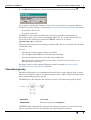
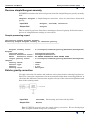
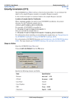
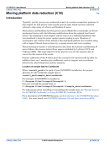
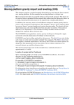
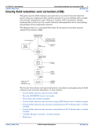
INTREPID User Manual
Library | Contents | Top
Gravity corrections available (T54a)
1
| Back |
Gravity corrections available (T54a)
Top
The INTREPID Gravity tool can calculate individual gravity corrections or gravity
anomalies for a gravity point dataset. It creates new fields to store these values.
Use the reverse anomaly corrections to recreate an obsgrav field for a dataset that
has only FreeAir or Bouguer fields.
Note: You automatically create the free air anomaly and the simple Bouguer
anomaly when you reduce loop data to final.
To perform these corrections
1
Check that you have specified the appropriate datum and density settings (see
"Gravity tool settings (T54b)" for details).
2
Choose Gravity Transforms from the Process menu.
Specify the gravity point dataset for correction.
Select the correction that you require.
Choose Finish.
3
Library | Contents | Top
INTREPID prompts you for the required input and output fields (see below for
details). INTREPID will not prompt for a field name if there is a corresponding
valid alias.
| Back |
INTREPID User Manual
Library | Contents | Top
4
Gravity corrections available (T54a)
2
| Back |
INTREPID displays the current settings (if any) to use in the calculation.
If you wish to change the settings, choose No to cancel gravity correction and then
modify the gravity settings as required (see "Gravity tool settings (T54b)" for details).
•
To continue, choose Yes.
•
To cancel, choose No.
INTREPID creates the new field in the gravity point dataset and appends a
processing report to the current processing report file. If you have not specified a
report file name during the current INTREPID session, it is named
processing.rpt by default.
The processing report does not display automatically, but you can locate the file in the
current directory.
You can
•
View the processing report using a text editor.
•
Use the Spreadsheet Editor to view the new field data.
•
Use the Visualisation tool to view the data graphically.
Tip: Assign the elevation field to point colour and the observed gravity or an
anomaly field to point size.
See Steps 2 and 3 of the complete Bouguer worked example in "Gravity field
reduction and correction (C08)" for details.
Theoretical gravity
The theoretical gravity is a mathematical model of the earth's gravity field. It takes
into account that the earth is an ellipsoid rather than a sphere. Each ellipsoid model
has a corresponding gravity datum.
INTREPID uses the latitude and datum to create a new theoretical gravity field.
Input field
Latitude
Output field
Theoretical gravity (theograv)
INTREPID also automatically subtracts the theoretical gravity as one of the steps
when it calculates the free air anomaly and simple Bouguer anomaly.
Library | Contents | Top
| Back |
INTREPID User Manual
Library | Contents | Top
Gravity corrections available (T54a)
3
| Back |
Sample processing report
Calculating theoretical gravity for all data base points
--------------------------------------------------------
Latitude field
: D:/Intrepid/cookbook/gravity/datasets/Survey9705/
Latitude
Calculated gravity field: D:/Intrepid/cookbook/gravity/datasets/Survey9705/
theograv
Gravity datum
: IGSN71
Gravity units
: Milligals
To convert data reduced to a different ellipsoid:
You may want to merge two datasets that were reduced to different ellipsoids. If the
datasets do not contain an observed gravity field you can use this option to revert to
observed gravity for one of the datasets. You can then reduce the observed gravity to
the required ellipsoid as usual.
1
From the Settings menu, select the datum that was used for the original
reduction. Choose Theoretical Gravity to calculate the theoretical gravity that
was subtracted from the observed gravity using this ellipsoid.
2
Use the spreadsheet editor to reapply (add) the theoretical gravity to the corrected
gravity field to recreate the observed gravity field obsgrav .See Step 2 of the
complete Bouguer worked example in "Gravity field reduction and correction
(C08)" for an example of using the Spreadsheet tool.
3
Select your preferred datum from the Settings menu (for example WGS84).
Calculate the theoretical gravity using this preferred datum.
4
Use the spreadsheet editor to subtract the revised theoretical gravity from the
observed gravity.
Library | Contents | Top
| Back |
INTREPID User Manual
Library | Contents | Top
Gravity corrections available (T54a)
4
| Back |
Free air anomaly
The free air correction compensates the observed gravity for the fact that it was
measured at a given height above (or below) the datum.
It assumes, however, that there is nothing but air between sea level and the
observation point.
INTREPID calculates the free air correction from the elevation and observed gravity
fields and the terrain type.
The free air anomaly is calculated as follows:
FreeAir = obsgrav - theoretical gravity - free air correction
Input field
obsgrav, Latitude, Elevation
Output field
FreeAir
Free air correction formula
Here is the formula for free air correction using the full formula expressed as a
vertical gradient. For IGSN71(GRS67) the formula is as follows (Robbins, 1981) and
(Fils, Butt, Hawke, 1998) (See "Free air references" in Gravity references (R32)):
δgh /δh = –2go/a[1 + f + m + (–3f + (5m)/2)sin2φ] + (6go/a2)*h
where
go
= equatorial gravity on the ellipsoid
f
= flattening coefficient
= 1/298.25
a
= semi-major axis radius of the ellipsoid
= 6378160 m
m
= centrifugal force at equator go
= 0.0034498014
φ
= latitude
h
= height above ellipsoid
= 9780318.456 µms–2
This can be expressed as:
Free Air correction
= (3.08768 – 0.00440 sin2φ )*h – 0.000001442*h2 µms–2 per metre;
Library | Contents | Top
| Back |
INTREPID User Manual
Library | Contents | Top
Gravity corrections available (T54a)
5
| Back |
Sample processing report
Calculating Free Air Anomaly
----------------------------
Observed gravity field
obsgrav
Latitude field
Station Elevation field
Meter
Elevation field
Output free air field
zzzz
Gravity datum
Terrain type
Gravity units
: D:/Intrepid/cookbook/gravity/datasets/Survey9705/
:
:
:
:
Survey9705/Latitude
Survey9705/Elevation
NO METER ELEVATION DATA BEING USED
D:/Intrepid/cookbook/gravity/datasets/Survey9705/
: IGSN71
: land
: Milligals
Reverse free air anomaly
Use this correction when your data contains a free air anomaly field but no observed
gravity field.
INTREPID adds the free air correction and the theoretical gravity to the free air
anomaly field to recreate the observed gravity field.
obsgrav = FreeAir + free air correction + theoretical gravity
Input field
FreeAir, Latitude, Elevation,
Output field
obsgrav
Sample processing report
Reversing Free Air anomaly to observed gravity.
----------------------------------------------
Free air gravity field
FreeAir
Latitude field
Station Elevation field
Meter
Elevation field
Output gravity field
obsgrav
Gravity datum
Terrain type
Gravity units
Library | Contents | Top
: D:/Intrepid/cookbook/gravity/datasets/Survey9705/
:
:
:
:
Survey9705/Latitude
Survey9705/Elevation
NO METER ELEVATION DATA BEING USED
D:/Intrepid/cookbook/gravity/datasets/Survey9705/
: IGSN71
: land
: Milligals
| Back |
INTREPID User Manual
Library | Contents | Top
Gravity corrections available (T54a)
6
| Back |
Simple Bouguer anomaly
The simple Bouguer correction replaces the "air" in the Free Air anomaly with rock.
INTREPID uses the observed gravity field and the specified density and datum
settings to calculate the simple Bouguer correction.
The simple Bouguer anomaly is calculated as follows:
Bouguer = obsgrav - theoretical gravity - free air correction - simple Bouguer
correction
Input field
obsgrav, Latitude, Elevation
Output field
FreeAir
You can experiment with different density settings to create a series of simple
Bouguer anomaly fields; for example Bouguer267, Bouguer250, Bouguer200 .
Sample processing report
Calculating Simple Bouguer Anomaly
----------------------------------
Observed gravity field : D:/Intrepid/cookbook/gravity/import_data/
Survey9533_0710/Bouguer
Latitude field
: D:/Intrepid/cookbook/gravity/import_data/Survey9533_0710/
Latitude
Station Elevation field : D:/Intrepid/cookbook/gravity/import_data/
Survey9533_0710/Elevation
Meter Elevation field : NO METER ELEVATION DATA BEING USED
Bouguer anomaly field : D:/Intrepid/cookbook/gravity/import_data/
Survey9533_0710/Bouguer2
Gravity datum
: IGSN71
Terrain type
: land
Density
: 2.670
Gravity units
: Milligals
Library | Contents | Top
| Back |
INTREPID User Manual
Library | Contents | Top
Gravity corrections available (T54a)
7
| Back |
Reverse simple Bouguer anomaly
INTREPID calculates the observed gravity from the simple Bouguer gravity anomaly
field.
obsgrav = Bouguer + simple Bouguer correction + free air correction + theoretical
gravity
Input field
Bouguer, Latitude, Elevation
Output field
obsgrav
This is useful if you have data that is missing an observed gravity field and want to
process it using different settings or corrections.
Sample processing report
Calculating Simple Bouguer Anomaly
Reversing Simple Bouguer anomaly to observed gravity
----------------------------------------------------
Bouguer anomaly field
Bouguer
Latitude field
Station Elevation field
Meter
Elevation field
Output gravity field
obsgrav
Gravity datum
Terrain type
Density
Gravity units
: D:/Intrepid/cookbook/gravity/datasets/Survey9705/
:
:
:
:
Survey9705/Latitude
Survey9705/Elevation
NO METER ELEVATION DATA BEING USED
D:/Intrepid/cookbook/gravity/datasets/Survey9705/
:
:
:
:
IGSN71
land
2.670
Milligals
Eötvös gravity correction
Use this correction for marine and airborne survey data before reducing loop data to
final. The correction compensates for measurements taken from a moving platform. It
calculates the difference between the angular velocity of the observation platform and
that of the rotating earth.
Input field
Latitude, line bearing and craft velocity fields
Output field
Eotvos
Tip: INTREPID currently uses the simple velocity correction. We are developing a
more complex method using cross correlation.
Library | Contents | Top
| Back |
INTREPID User Manual
Library | Contents | Top
Gravity corrections available (T54a)
8
| Back |
Sample processing report
Calculating Eotvos gravity for all data base points
---------------------------------------------------
Latitude field
:
Latitude
Line bearing field
:
bearing
Craft velocity field
:
velocity
Calculated Eotvos field:
Eotvos
Gravity units
:
D:/Intrepid/cookbook/gravity/datasets/Survey9705/
D:/Intrepid/cookbook/gravity/datasets/Survey9705/
D:/Intrepid/cookbook/gravity/datasets/Survey9705/
D:/Intrepid/cookbook/gravity/datasets/Survey9705/
Milligals
Applying the correction
Use the spreadsheet editor to subtract the Eötvös correction from the observed
gravity field obsgrav to create a new observed gravity field.See "Complete Bouguer
anomaly—worked example" in Gravity field reduction and correction (C08) for an
example of using the Spreadsheet tool.
Other gravity operations
Gravity Wizard
Use this to start processing gravity data part way through the usual processing
sequence.
Select Gravity Wizard from the Process menu.
Observed gravity adjustments and corrections
Gravity meter calibration
Datasets can contain calibration data. You can use this data to recalculate the scale
factors for a gravimeter. Information about scale factors is included in Section 3 of the
processing report. See "Gravimeter calibration (R29)" for details.
Select Gravity Meter Calibration from the Tools menu.
Specify the dataset that contains the calibration data.
Library | Contents | Top
| Back |
INTREPID User Manual
Library | Contents | Top
Gravity corrections available (T54a)
9
| Back |
Earth Tides
The Sun, moon and planets affect gravity at any place on the earth.
Use this to calculate the tidal corrections for a specified region of the Earth.
INTREPID uses the Longman formula.
Select Earth Tides from the Tools menu.
Specify the location and time interval.
INTREPID automatically applies Earth tide corrections during the import process.
Information about the Earth tide correction is included in Section 2 of the processing
report.
Convert to WGS84
Use this to convert a gravity dataset to the WGS84 datum Specify the new gravity
dataset name in the Specify Output Dataset dialog box.
Library | Contents | Top
| Back |