1
INTREPID User Manual
Library | Help | Top
Moving platform gravity import and levelling (C09)
1
| Back |
Moving platform gravity import and levelling (C09)
Top
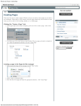
This chapter contains a worked example showing how to level gravity data acquired
on a moving platform. In this example the moving platform is a ship at sea.
Most marine gravity data is acquired during a seismic work program. The layout of
the survey lines is optimised for the seismic data rather than for the gravity data. As
a result, marine gravity data may not be acquired on a regular grid pattern.
In addition, the user may want to level different vintages of marine gravity data to
create a self consistent levelled dataset. The problem is then to level a dataset which
has survey lines of varying lengths and varying bearing angles. The density of data
observations may also vary significantly from one place to another. This makes it
difficult, if not impossible, to use standard levelling methods which have been
designed for regularly flown airborne data
The INTREPID moving platform marine gravity levelling was designed to apply
systematic network adjustments (‘levelling’) to these datasets.
INTREPID uses line levelling methods for this process. The Split Cruise tool divides
each cruise or sortie into 'reasonably straight' line segments. The Marine Level tool
then applies a network adjustment to the survey data. There are various options for
doing this. The adjustment can be done either with or without reference to an
external dataset, eg: satellite altimeter data.
The marine gravity data used in this example has a nominal precision of
approximately ± 2 mGal.
Location of sample data for Cookbooks
Where install_path is the path of your INTREPID installation, the project
directory for the Cookbooks sample data is
install_path\sample_data\cookbooks.
For example, if INTREPID is installed in
C:\Program Files\Intrepid\Intrepid4.5,
then you can find the sample data at
C:\Program Files\Intrepid\Intrepid4.5\sample_data\cookbooks
For information about installing or reinstalling the sample data, see "Sample data for
the INTREPID Cookbooks" in Using INTREPID Cookbooks (R19).
For a description of INTREPID datasets, see Introduction to the INTREPID database
(G20). For more detail, see INTREPID database, file and data structures (R05).
Library | Help | Top
© 2012 Intrepid Geophysics
| Back |
INTREPID User Manual
Library | Help | Top
Moving platform gravity import and levelling (C09)
2
| Back |
Moving platform import and levelling worked example 1
Overview
1 Import the raw data into INTREPID line datasets using the Import tool.
2
Split the cruises into reasonably straight line segments using the Split Cruise
tool.
3
Use the Observed gravity to calculate the FreeAir anomaly. Convert units from
μm/s2 to milliGals.
4
Merge the separate line datasets using the Project Manager's Append operation.
5
Use the Marine Level tool to compute and apply a network adjustment using the
method of loop closure levelling. This method adjusts the data to be internally
consistent, and does not require an external reference dataset such as a satellite
altimeter model.
6
Grid and examine the results.
Preliminary notes
The example data can be found in
install_path\sample_data\cookbooks\levelling\marine.
The raw data for each cruise is contained in an ASCII file. The files contain water
depth, gravity and magnetic data. We are only processing the gravity data.
The file names are, for example:
0004.asc
0097.asc
0136an.asc
1339.asc
0053.asc
0101an.asc
0161.asc
1359fd.asc
0055.asc
0110an.asc
0167an.asc
0056an.asc
0127an.asc
0168a.asc
0096.asc
0128.asc
0174an.asc
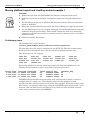
Each of the ASCII files has the following format (the first line shown here is to
identify the field names for these steps and is not part of the file.)
Survey Time Latitude Longitude
3.016.0740 -11.82834 131.55832
3.016.0750 -11.80500 131.56165
3.016.0800 -11.78334 131.56333
depth
-21
-24
-29
gravity
9782666
9782670
9782670
mag
46040
46032
46024
residual_mag
20
28
34
INTREPID has powerful batch processing tools, which make it simple to process
multiple files in a single run. The following steps include examples of task
specification files, which can process all of the data together. Naturally, before using
this feature, you would conduct tests using the INTREPID tools interactively. Note,
however, that the Split Cruise and Marine Level tools are only available in batch
mode in the current version of INTREPID.
Library | Help | Top
© 2012 Intrepid Geophysics
| Back |
INTREPID User Manual
Library | Help | Top
Moving platform gravity import and levelling (C09)
3
| Back |
Steps to follow
1
Import the ASCII files into INTREPID line datasets and assign them the
following names:
raw0004
raw0097
raw0136an
raw1339
raw0053
raw0055
raw0056an
raw0101an raw0110an raw0127an
raw0161
raw0167an raw0168a
raw1359fd
raw0096
raw0128
raw0174an
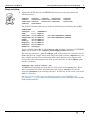
Use ASCII Columns input format with the following data definition file (DDF):
TYPE(LINE)
SurveyID 1-4
INTEGER*4
Time
6-13 REAL*8
Latitude 14-23 REAL*8
IsY PROJ(GEODETIC,WGS84)
Longitude 25-33 REAL*8
IsX PROJ(GEODETIC,WGS84)
Depth
34-39 REAL*4
Gravity
40-47 REAL*8
Magnetic 48-53 REAL*8
Residual 54-59 REAL*8
GROUP BY SurveyID
In our example, this DDF is called marine.ddf. Further examples of INTREPID
DDFs can be found in the install_path/examples/DDF directory.
The task specification (.job) file import.job will perform the operation for all
nnnn.asc files in a single batch task. Since this task contains a Repeat loop, you
must submit it to the Project Manager rather than directly to the Import tool.
To run the task, assuming that the task specification file is called import.job,
use the command:
fmanager.exe –batch import.job
INTREPID will perform the task once for each value in the Inputs list. Each
time it performs the task it will substitute the current Inputs value for the
parameter $Inputs in the task specification. In this way it will create each of the
rawnnnn datasets.
See "Special Project Manager batch task operations" in INTREPID task
specification (.job) files (R06) for full instructions on the techniques used in this
task specification file.
Library | Help | Top
© 2012 Intrepid Geophysics
| Back |
INTREPID User Manual
Library | Help | Top
Moving platform gravity import and levelling (C09)
4
| Back |
For each Inputs value the Import tool imports the nnnn.asc file into the
corresponding rawnnnn dataset.
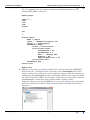
Repeat Begin
Inputs = {
0004
0053
0055
0056an
.
.
etc
}
Process Begin
Name = import
Input = ./Rawdata/$(Inputs).asc
Output = ./raw$(Inputs)
Parameters Begin
Format = AsciiColumns
AsciiColumns Begin
FixedLength = No
SkipRecords = 0
DDF = "./marine.ddf"
NoError = No
ReportDiagnostics = No
AsciiColumns End
Parameters End
Process End
Repeat End
2
Split the cruises into 'reasonably straight' line segments using the INTREPID
Split Cruise tool. The Split Cruise tool creates a new SPLITLINE field, which
assigns a unique line number for each straight line segment. This line number is a
combination of the SurveyID and the sequentially numbered line segment within
the dataset divided by 10000. For example, a split dataset created from a dataset
with SurveyID 5 would have line numbers 5.0001, 5.0002, 5.0003, …
Using the current version of INTREPID you can run the Split Cruise tool in batch
mode or by selecting the Marine Split tool found under Levelling of the Project
Manager.
Library | Help | Top
© 2012 Intrepid Geophysics
| Back |
INTREPID User Manual
Library | Help | Top
Moving platform gravity import and levelling (C09)
5
| Back |
The task specification (.job) file splitcruise.job will perform the operation
for all rawnnnn datasets in a single batch task. Since this task file contains a
Repeat loop, you must submit it to the Project Manager rather than directly to
the Split Cruise tool.
To run the task, assuming that the task specification file is called
splitcruise.job, use the command.
fmanager.exe –batch splitcruise.job
INTREPID will perform the task once for each value in the Inputs list. Each
time it performs the task it will substitute the current Inputs value for the
parameter $Inputs in the task specification. In this way it will create each of the
splitnnnn datasets.
For each Inputs value the Split Cruise tool divides the in the rawnnnn dataset
into reasonably straight segments and creates the corresponding splitnnnn
dataset. The Inputs list is the same as in step 1 above.
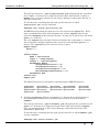
Repeat Begin
Inputs = {
...
}
Process Begin
Name = splitcruise
Input = ./raw$(Inputs)
Output = ./split$(Inputs)
Parameters Begin
SharpAngleTolerance = 50
TrendAngleTolerance = 45
TrendDistanceInSamples = 10
MinimumSamplesBeforeDrop = 10
Parameters End
Process End
Repeat End
The SplitCruise process will produce the following INTREPID datasets:
split0004
split0097
split0136an
split1339
3
split0053
split0055
split0056an
split0101an split0110an split0127an
split0161
split0167an split0168a
split1359fd
split0096
split0128
split0174an
Convert the gravity field in each splitnnnn dataset from μm/s2 gravity to
mGal free-air anomaly values and store the results in a new field called
FreeAir.
The task specification (.job) file freeair.job will perform the operation for all
splitnnnn datasets in a single batch task. Since this task contains a Repeat
loop, you must submit it to the Project Manager rather than directly to the
Spreadsheet Editor tool.
To run the task, assuming that the task specification file is called freeair.job,
use the command.
fmanager.exe –batch freeair.job
Library | Help | Top
© 2012 Intrepid Geophysics
| Back |
INTREPID User Manual
Library | Help | Top
Moving platform gravity import and levelling (C09)
6
| Back |
INTREPID will perform the task once for each value in the Inputs list. Each
time it performs the task it will substitute the current Inputs value for the
parameter $Inputs in the task specification. In this way it will process each of
the splitnnnn datasets.
For each Inputs value the Spreadsheet Editor opens the corresponding
splitnnnn dataset and creates a new field called FreeAir. The Inputs list is
the same as in step 1 above.
Repeat Begin
Inputs = {
...
}
Process Begin
Name = dbedit
Parameters Begin
Action Begin
Type = OpenField
Name = ./split$(Inputs)
Action End
Action Begin
Type = CreateField
Name = "FreeAir"
Dtype = IEEE8ByteReal
Width = 10
GroupBy = No
Initial = "FA(Latitude,Gravity/10)"
Action End
Parameters End
Process End
Repeat End
The function FA() is a user defined DLL/SO function. As used here it converts all
of the values of the field Gravity to free air anomaly values, which it returns as
the values of the function. (The arguments and the returned value of the function
both represent arrays of values.) The calculation uses the respective value of the
Latitude field in each case.
Note: The gravity value is divided by 10 before processing by FA(). This
converts it from μm/s2 to mGal, required by the FA() function. In this example
the FreeAir is then converted from mGals back to μm/s2 by using the Spreadsheet
Editor.
See "User defined DLL/SO functions" in The INTREPID SDK and API (R18) for
full instructions on creating and using these functions.
Note: The same process is available in batch mode using the INTREPID Gravity
tool
Library | Help | Top
© 2012 Intrepid Geophysics
| Back |
INTREPID User Manual
Library | Help | Top
Moving platform gravity import and levelling (C09)
7
| Back |
Here is a listing of the FA() function
/*
* This program does the IGSN71 Free Air Anomaly calculation.
*
* This program uses dynamic library calls
* from within the INTREPID Spreadsheet Editor tool.
* You must compile this program and put it into a shared library
*
* Under UNIX it must have the name libFA.so.
* and it must reside in the directory specified by the library
* path ($LD_LIBRARY_PATH).
* Under Windows it must have the name libFA.dll
* and it must reside in a directory listed by the environment
* variable PATH.
*
* We designed this module to be called from the INTREPID
.* Spreadsheet Editor tool(dbedit.exe) as FA(lat,obsgravity).
* Where lat is in latitude degrees.
*
obsgravity is in mgals .
*
* The prototype for a function xxx(f1,f2,...,fn) is
* double* xxx(int npts,double* f1,double* f2,...,double* fn)
*/
#include <stdio.h>
#include <math.h>
double* FA(int npts,double* lat,double* obsgravity) {
double PI=3.14159265358979323846;
double* FAvalue = lat;
double flt64Null = -5.0E+75; /* This represents a null value */
int i;
/* Perform the calculation */
double a1=978031.85;
double a2= 0.005278895;
double a3= 0.000023462;
double sl,calcgrav;
for (i=0;i<npts;i++) {
if (lat[i]!=flt64Null && obsgravity[i]!=flt64Null) {
sl = sin(lat[i]*PI/180.0);
calcgrav = (a1*(1.0+a2*sl*sl+a3*sl*sl*sl*sl));
/*printf("lat %d %lf %lf %lf lf\n",
i,lat[i],sl,calcgrav,obsgravity[i]);*/
FAvalue[i] = obsgravity[i]-calcgrav;
}
else FAvalue[i] = flt64Null;
}
return(FAvalue);
}
Library | Help | Top
© 2012 Intrepid Geophysics
| Back |
INTREPID User Manual
Library | Help | Top
4
Moving platform gravity import and levelling (C09)
8
| Back |
Merge the separate line datasets using the Project Manager's Append operation.
Up until now we have processed the raw data as separate surveys, one dataset per
survey. Whether we keep the survey data separate or merge all the surveys into a
single dataset really depends upon the network adjustment (levelling) strategy we
wish to use. In this example we are going to use loop closure levelling to perform
an internal network adjustment of all of the crossover points for all of the surveys.
Because the adjustment is completely internal, ie; we are using no external
dataset as a reference, all of the survey data must reside in a single dataset, in
order for the Marine Level tool to find all of the crossover points.
The task specification (.job) file append_datasets.job will perform the
operation for all splitnnnn datasets in a single batch task. Since this task
contains a Repeat loop, you must submit it to the Project Manager.
To run the task, assuming that the task specification file is called
append_datasets.job, use the command.
fmanager.exe –batch append_datasets.job
INTREPID will perform an append task once for each value in the dataset list.
A new dataset, called master..DIR, will be created from appending all of the
splitnnnn datasets together.
Library | Help | Top
© 2012 Intrepid Geophysics
| Back |
INTREPID User Manual
Library | Help | Top
5
Moving platform gravity import and levelling (C09)
9
| Back |
Use the Marine Level tool to perform an internal network adjusment using all of
the crossovers as control points. Marine Level will calculate the crossover points
then minimise the misclosure errors throughout the crossover network, using the
method of loop closure levelling.
Using the current version of INTREPID you must run the Marine Level tool in
batch mode.
The task specification (.job) levelloop.job will perform the network
adjustment on the master..DIR dataset.
To run the task, assuming that the task specification file is called
levelloop.job, use the command.
fmanager.exe –batch levelloop.job
The Marine Level tool will process the input FreeAir field. It stores the levelled
data in a new field called FreeAir_loop.
Process Begin
Name = marinelevel
Comments= "Intrepid Audit Stamp ..."
ReportFile= marine_level.rpt
# Primary input dataset
Dataset = ./master..DIR
InputZ = ./master..DIR/FreeAir
OutputZ = ./master..DIR/FreeAir_loop
# Xovers
OutputXover = ./crossovers..DIR
Parameters Begin
Method Begin
RunType= LevelLoop
ByCruise= No
Method End
PopulationAnalysis= Yes
SaveEmptyGroupsInXover= Yes
DoPseudoFidsAsRecords= Yes
DuplicateCrossOver_Fid_Tolerance= 0.001
MaximumPointSeparation= 10000.0
MaximumInterpolationGap= 10000.0
WeightMethod= Unity
Parameters End
Process End
Library | Help | Top
© 2012 Intrepid Geophysics
| Back |
INTREPID User Manual
Library | Help | Top
Moving platform gravity import and levelling (C09)
10
| Back |
Parameters
RunType: If the crossover adjustment is done without reference to an external
dataset, then the valid options are LevelLoop and LevelPolynomial. See "Loop
closure levelling" in Chapter 1 "Levelling line datasets" in Reference Manual
volume 3 for further information about the loop levelling process.
ByCruise: Set this to Yes if you wish to perform levelling by cruise. The splitcruise
process will generate some 'lines' for which no crossovers are found. This option
determines whether these lines get levelled or not. In levelling by cruise, the
levelling process is applied to the whole of a cruise, and completely ignores the
break-down into the 'lines' that were created by the split-cruise process.
PopulationAnalysis: Set this to Yes if you wish to generate statistical reports for
the input dataset(s), based upon histograms of crossover populations.
SaveEmptyGroupsInXover: Running Split Cruise often results in line segments
which have no crossovers. Normally, crossover datasets do not include line
segments with no crossovers. Set this to Yes if you wish to include them.
DoPseudoFidsAsRecords: The Marine Level tool requires a fiducial field to
calculate the levelling adjustment. Usually this would be Time. If your data has
no fiducial field, set this option to Yes, in which case the process will create a
pseudo fiducial. (If this is not selected and there is no fiducial, the process will use
the cumulative distance as a fiducial.)
DuplicateCrossOver_Fid_Tolerance: A rejection criteria for crossover points. If
crossover points occur very close together they can cause levelling problems. This
parameter sets a minimum tolerance on the allowable distance between
crossovers. Where two crossovers are within this separation, one is rejected. The
value has the same units as the X and Y fields (in this example 0.001 degrees
(approx. 1 km)).
MaximumPointSeparation: A rejection criteria for crossover points. Where the
survey points exceed this separation, the crossover is deemed less reliable, and is
rejected. The value has the same units as the X and Y fields (in this example
10000 degrees, so effectively no limit).
MaximumInterpolationGap: This parameter controls the use of spline versus
linear interpolation. For example, a value of zero forces linear interpolation
everywhere. The value has the same units as the Fiducial field.
WeightMethod: In polynomial levelling, one part of the process requires fitting a
polynomial to the misclosure data. A weighting scheme can be specified which
determines the relative importance (or weight) of crossovers in the fitting process.
Library | Help | Top
© 2012 Intrepid Geophysics
| Back |
INTREPID User Manual
Library | Help | Top
Moving platform gravity import and levelling (C09)
11
| Back |
Saving and loading crossovers
You can save a set of crossovers as a point dataset, and load it again during
subsequent sessions. If you load a set of crossovers, INTREPID will use them
instead of calculating a new set. For a large dataset this can represent a
considerable saving of time. A crossover dataset also records the corrections which
were calculated when it was created. If you set all levelling correction methods to
No INTREPID will apply the levelling correction recorded in the crossovers
dataset.
To save a crossovers dataset, use the statement OutputXOver = before the
Parameters Begin statement to specify the crossover dataset to be created.
To load a crossovers dataset, use the statement InputXOver = before the
Parameters Begin statement to specify the crossover dataset to be used.
Gridding
6
Library | Help | Top
Grid the data and review the grid. The task specification (.job) file
grid_var.job will perform the operation using an algorithm suitable for
variable density data. Examine the grid using a sun angle view to locate levelling
errors. You may wish to grid the unlevelled data and compare the two grids side
by side. If you find errors, you may need to examine the raw data more closely.
Further processing options would be to
•
Examine the raw data for errors;
•
Adjust the levelling parameters;
•
Remove the line or lines causing the levelling error;
•
Use the INTREPID Flight Path Editor to clip sections of lines at ship turning
points. The acceleration caused by turning may cause gravity errors.
© 2012 Intrepid Geophysics
| Back |
INTREPID User Manual
Library | Help | Top
Moving platform gravity import and levelling (C09)
12
| Back |
Moving platform import and levelling worked example 2
Overview
1 Import the raw data into INTREPID line datasets using the Import tool.
2
Split cruises into reasonably straight line segments using the Split Cruise tool.
3
Convert the gravity field from μm/s2 gravity to mGal free-air anomaly
values.
4
Prepare a satellite altimeter-derived gravity image for use as a levelling reference
surface. In the following example this preparation has been done for you.
5
Use the Marine Level tool to compute and apply a network adjustment using the
method of least squares piecewise polynomial fit.. This method adjusts the data to
fit onto the lower resolution satellite altimeter regional gravity dataset. This
dataset is also referred to as an external reference dataset.
6
Grid and examine the results.
Steps to follow
1
Import the ASCII files into INTREPID line datasets. Follow Step 1 of the previous
example.
2
Split the cruises into 'reasonably straight' line segments using the INTREPID
Split Cruise tool. Follow Step 2 of the previous example.
3
Convert the gravity field in each splitnnnn dataset from μm/s2 gravity to
mGal free-air anomaly values and store the results in a new field called
FreeAir. Follow Step 3 of the previous example.
Prepare levelling reference surface
4
Prepare a satellite altimeter-derived gravity image for use as a levelling reference
surface. Essentially this involves converting an image into an INTREPID line
dataset with crossover control points. There are several steps required in doing
this, and for the purpose of this exercise we have done the preparation for you. In
this example we have used the Global Gravity Grid (v7.2) by Sandwell and Smith.
These data are also referred to as the Geosat data, since much of the data was
derived from that satellite. It has a resolution of 2 minutes (approx. 3700 metres
or 0.033 degrees). The grid was downloaded from the TOPEX FTP site (FTP site :
ftp://topex.ucsd.edu/pub/global_grav_2min/). The full image occupies
approximately 70 Mbytes.
We found it beneficial to remove some high frequency noise (less than 30 km
wavelength) from the image. To do this, import it to an INTREPID grid dataset
using the Binary Image import format. Use the INTREPID Subsection tool to
extract the geographic region you require. Use the INTREPID Spectral Domain
Grid Filters to apply a low pass filter. Export the resulting grid to a file in ASCII
Image XYZ format.
Library | Help | Top
© 2012 Intrepid Geophysics
| Back |
INTREPID User Manual
Library | Help | Top
Moving platform gravity import and levelling (C09)
13
| Back |
The exported data should be similar to the following. (The first line shown here is
to identify the field names for these steps and is not part of the file.)
(Longitude
118.017
118.083
118.350
118.383
118.450
118.483
118.550
118.583
118.617
118.750
Latitude
-6.99924
-6.99924
-6.99924
-6.99924
-6.99924
-6.99924
-6.99924
-6.99924
-6.99924
-6.99924
FreeAir)
51.8000
49.4000
71.4000
75.4000
86.2000
90.4000
97.2000
99.0000
98.8000
113.000
Sort this file in order of Longitude and save it as geosatA. Sort the file in order
of Latitude and save it as geosatB.
Append geosatB to geosatA.
Import geosatA into an INTREPID line dataset called geosat..DIR. Use ASCII
Columns input format. The following data definition file (DDF) is suitable for the
example above.
TYPE(LINE)
Longitude 5-11 REAL*8 IsX PROJ(GEODETIC,WGS84)
Latitude 14-22 REAL*8 IsY PROJ(GEODETIC,WGS84)
FreeAir
REAL*4
Split the geosat..DIR dataset into 'reasonably straight' line segments using the
INTREPID Split Cruise tool. Call the resulting dataset split_geosat..DIR.
This dataset will contain a set of North-South lines covering the survey area and a
set of East-West lines also covering the survey area. Importantly, this dataset
contains crossover control points which are used by the INTREPID MarineLevel
tool. This split_geosat..DIR dataset is provided for you.
Library | Help | Top
© 2012 Intrepid Geophysics
| Back |
INTREPID User Manual
Library | Help | Top
Moving platform gravity import and levelling (C09)
14
| Back |
Marine Level
5
Use the Marine Level tool to fit the individual surveys (splitnnnn) onto the
lower resolution satellite based regional gravity using a least squares piecewise
polynomial fit. Marine Level compares crossovers of the cruise data with the
satellite data in the levelling process.
Up until now we have processed the raw data as separate surveys, one dataset per
survey. Whether we keep the survey data separate or merge all the surveys into a
single dataset really depends upon the network adjustment (levelling) strategy we
wish to use. In this example we are going to use polynomial levelling to perform a
network adjustment of the crossover points for all of the surveys, using the geosat
dataset as the reference surface. Because we are using an external dataset as a
reference, there is no need for all of our survey data to reside in a single dataset.
We can process the splitnnnn datasets individually, without having to append
them together.
Using the current version of INTREPID you must run the Marine Level tool in
batch mode.
The task specification (.job) file levelpoly.job will perform the Marine Level
task for all splitnnnn datasets in a single batch task. Since this task contains a
Repeat loop, you must submit it to the Project Manager rather than directly to
the Marine Level tool.
To run the task, assuming that the task specification file is called
levelpoly.job, use the command.
fmanager.exe –batch levelpoly.job
INTREPID will perform the task once for each value in the Inputs list. Each
time it performs the task it will substitute the current Inputs value for the
parameter $Inputs in the task specification. In this way it will process each of
the splitnnnn datasets.
For each Inputs value the Marine Level tool opens the corresponding splitnnnn
dataset levels the FreeAir field. It stores the levelled data in a new field called
FreeAir_poly. The Inputs list is the same as in step 1 above.
Library | Help | Top
© 2012 Intrepid Geophysics
| Back |
INTREPID User Manual
Library | Help | Top
Moving platform gravity import and levelling (C09)
15
| Back |
Repeat Begin
Inputs = {
...
}
Process Begin
Name = marinelevel
Comments= "Intrepid Audit Stamp ...
ReportFile= marine_level.rpt
# Primary input dataset
Dataset = ./split$(Inputs)
InputZ = ./split$(Inputs)/FreeAir
OutputZ = ./split$(Inputs)/FreeAir_poly
# Reference dataset
OtherDataset = ./split_geosat
OtherInputZ = ./split_geosat/FreeAir
# Xovers
#OutputXover = ./crossovers..DIR
Parameters Begin
Method Begin
RunType= LevelPolynomial
ByCruise= No
Method End
PopulationAnalysis= Yes
SaveEmptyGroupsInXover= Yes
DoPseudoFidsAsRecords= Yes
DuplicateCrossOver_Fid_Tolerance= 0.001
MaximumPointSeparation= 10000.0
MaximumInterpolationGap= 10000.0
Polynomial Begin
Width = 15
Order = 0
MinNpts= 2
ConvolveWidth= 5
DistanceWeighted= No
Polynomial End
WeightMethod= Unity
Parameters End
Process End
Repeat End
Library | Help | Top
© 2012 Intrepid Geophysics
| Back |
INTREPID User Manual
Library | Help | Top
Moving platform gravity import and levelling (C09)
16
| Back |
Parameters
RunType: If the crossover adjustment is done with reference to an external dataset,
then the valid options are LevelPolynomial, LevelDC, LevelLinesDC and
LevelDrape. If you choose the LevelPolynomial option you must include the
following four Polynomial parameters.
Polynomial Width: Use this to specify the number of crossover points to use in the
piecewise polynomial used for levelling.
Polynomial Order: Use this to specify the order of the polynomial fit.
Polynomial Minimum Points: Use this to specify the minimum number of
crossover points in a line for the levelling adjustment to be applied. INTREPID
will not attempt to adjust lines with fewer crossover points than you specify here.
Polynomial Convolve Width: After INTREPID calculates the levelling corrections
it applies a smoothing convolution filter to the data. This filter removes high
frequency components of the data. Use this parameter to specify the width (in
data points) of the convolution kernel.
LevelDC: Use this option if you wish to make a 'DC' adjustment (add or subtract a
constant value) to the entire dataset such that it best fits the external reference
dataset.
LevelLinesDC: Use this option if you wish to make a 'DC' adjustment (add or
subtract a constant value) to individual line segments within the dataset such
that it best fits the external reference dataset.
LevelDrape: Use this option if you wish to adjust the input dataset to the reference
dataset using piecewise linear interpolation, making all misclosures equal to zero.
Library | Help | Top
© 2012 Intrepid Geophysics
| Back |
INTREPID User Manual
Library | Help | Top
Moving platform gravity import and levelling (C09)
17
| Back |
Gridding
6
Library | Help | Top
Grid the data and review the grid. The task specification (.job) file
grid_multivar.job will perform the operation using an algorithm suitable for
variable density data. It will read the data from a list of separate datasets,
avoiding the need to append all of the data together into a single dataset.
Examine the grid using a sun angle view to locate levelling errors. You may wish
to grid the unlevelled data and compare the two grids side by side. If you find
errors, you may need to examine the raw data more closely. Further processing
options would be to
•
Examine the raw data for errors;
•
Adjust the levelling parameters;
•
Remove the line or lines causing the levelling error;
•
Use the INTREPID Flight Path Editor to clip sections of lines at ship turning
points. The acceleration caused by turning may cause gravity errors.
© 2012 Intrepid Geophysics
| Back |