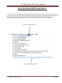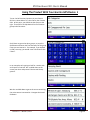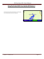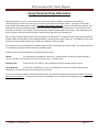
1
RV Directions 2011 User’s Manual RV Directions, LLC 218 Quinlan Street #405 Kerrville, FL 33037 Phone: (908) 489-6908 Release 1.1 – March 8, 2011 Page 1 RV Directions 2011 User’s Manual LE GA L NO T I C E S Copyright © 2011 RV Directions, LLC. All rights reserved. No part of this publication may be transmitted, transcribed, reproduced, stored in any retrieval system or translated into any language or computer language in any form or by any means, mechanical, electronic, magnetic, optical, chemical, manual, or otherwise, without prior written consent from RV Directions, LLC, 218 Quinlan Street, #405, Kerrville, Texas 78028. Printed in the United States of America. The software described in this book is furnished under license and may be used or copied only in accordance with the terms of such license. IMPORTANT NOTICE RV Directions, LLC provides RV Directions 2011 and this publication "as is" without warranty of any kind, either express or implied, including but not limited to the implied warranties of merchantability or fitness for a particular purpose. Some states or jurisdictions do not allow disclaimer of express or implied warranties in certain transactions; therefore, this statement may not apply to you. RV Directions, LLC reserves the right to revise this publication and to make changes from time to time in the content hereof without obligation of RV Directions, LLC to notify any person of such revision or changes. RV Directions does not warrant, guarantee or endorse any of the campgrounds, organizations, or businesses identified in this publication or in the RV Directions 2011 product. RV Directions does not assume any responsibility and expressly disclaims any liability for errors, omissions, or inaccuracies pertaining to the information in this publication or in the RV Directions 2011 product. TRADEMARKS AND CREDITS All company names or product names referenced in the product or in this document may be the trademarks of their respective holders. Release 1.1 – March 8, 2011 Page 2 RV Directions 2011 User’s Manual CO N T E N T S 1. Introduction 4 2. What’s New In The 2011 Release 6 3. Product Overview 7 4. Interpretation Of Information 8 5. Product Installation 10 6. Using The Product With Streets & Trips - Creating Your Own Group Of Locations 11 16 7. Using The Product With Street Atlas 18 8. Installing RV Directions To Your Garmin Device 23 9. Using The Product With Your Garmin Device 26 10. Using The Scenic Drive Information - Index Of Scenic Drives 30 32 Appendix – Directory of RV Directions Files 37 Release 1.1 – March 8, 2011 Page 3 RV Directions 2011 User’s Manual Introduction RV Directions 2011 is a collection of mapping locations that are of interest to the active RV’er. It is an add-on product that will work on any PC that is equipped with Microsoft’s Streets and Trips (2006 and later) or with DeLorme’s Street Atlas Plus (2006 and later). It will also work with Garmin GPS units. The locations include campgrounds, and major highway rest areas and truck stops to help the RV’er while traveling. Hospitals and RV service companies are now included to help the RV’er deal with emergencies that they may encounter while on the road. Many difficult mountain passes and grades are identified as are many low clearance bridges. It includes restaurants (like Cracker Barrel) and shopping locations (like Walmart) to help the RV’er find a good meal and stock up on supplies while en route to their destination or at their destination. RV Directions includes public golf courses and casinos, and wineries & vineyards, to help RV’ers find recreation and touring opportunities during their travels. It also includes Eagle Lodges, Elks Lodges and Moose Lodges that provide overnight RV parking facilities to traveling Eagle, Elk or Moose members. Many private campgrounds are rated in RV Directions 2011. The ratings can range from 0 to 100. The ratings are based upon compilation and averaging of the ratings of several campground rating sources. In other words, they provide a reasonable consensus opinion of the quality of a campground. Most campgrounds, private and public, will have an indication of the typical cost for a night’s stay, with full hookups if available, for a two people in a motor home. The cost categories are under $20, $20 to $30, $30 to $40, and over $40. Internet access has become increasingly important to today’s RV’er. Probably the most popular form of internet access is WiFi, where the RV’er can establish an internet connection from within his or her own RV. Consequently, RV Directions has included WiFi information for private campgrounds. RV Directions 2011, when used with one of the map programs, will show the location of a point of interest by a colored icon. Information about each campground, such as cost, ratings, site characteristics, etc. is readily available by selecting the icon (in Streets and Trips) or by selecting Info (Street Atlas). In addition, the icon itself may provide information about the campground such as WiFi availability or RV parking availability. The same information is available for a Garmin GPS unit. Release 1.1 – March 8, 2011 Page 4 RV Directions 2011 User’s Manual Other location categories will also contain information that is relevant to the location: Truck stop location information includes availability of propane and dump facilities, as well as identification of restaurants and food services associated with the truck stop. Rest stop location information includes availability of food and gas and RV dump facilities. Camping World information includes availability of dump and propane facilities and defines if overnight parking is allowed. Walmart, Cabela’s and Bass Pro Shop location information describes if overnight parking is allowed. Cracker Barrel and Bob Evans restaurants will describe if parking for RV’s is available. Hospital information includes hospital size (number of beds). The four RV service organizations each indicate the type of facility. And more. Please read the following pages for additional information. Release 1.1 – March 8, 2011 Page 5 RV Directions 2011 User’s Manual What’s New In the 2011 Release? There are many new features and improvements in the RV Directions 2011 release. These are summarized below: NEW FEATURES: 1. Expanded Coverage Of Canadian Locations 2. New Campground Affiliations a. Best Parks In America b. North American Camping Club 3. More Campgrounds a. 12,336 Private Campgrounds b. 10,650 Public Campgrounds 4. More Truck Stops a. 2,428 Truck Stops 5. New Recreation Locations a. Gun Clubs b. NASCAR Race Tracks c. Skiing Locations 6. New Shopping Locations a. Home Depot b. K-Mart 7. Medical Care for Pets a. Hospitals b. Veterinarians 8. Low Clearance Bridges a. Up to 15’0” 9. Eagle Lodges that provide RV parking IMPROVEMENTS 1. Updates and additions to existing data 2. Updated latitude/longitude data 3. Campground information now includes a. Handicap Access b. Cable TV c. Fishing and Boating d. Pool e. Church Services f. Campground Elevation g. Site Escort h. Pull Through Site Sizes (Width x Length) i. Back In Site Sizes (Width x Length) Release 1.1 – March 8, 2011 Page 6 RV Directions 2011 User’s Manual Product Overview The location information in RV Directions 2011 includes data that will work with Microsoft Streets & Trips (stt template files) and data that will work with DeLorme Street Atlas (dds XData dataset files). It includes CSV (Comma Separated Variable) data that has been specially formatted for use on Garmin GPS Units. In addition, CSV data is provided for all locations to allow the user to create their own groupings of RV locations information. The product organizes information within several groups. These groups are replicated for Garmin, Street Atlas and Streets & Trips: Campground Affiliations Campgrounds – Military Campgrounds – Private Campgrounds – Public Dealing with Emergencies Fraternal Lodges On The Road Locations Post Offices Recreation Locations Restaurants Shopping In addition, 120 spectacular road trips from the Readers Digest book “The Most Scenic Drives in America” are included. Any of these trips can be integrated into your route planning. Release 1.1 – March 8, 2011 Page 7 RV Directions 2011 User’s Manual Interpretation of Information The information contained in RV Directions must be properly interpreted if you want to get maximum benefit from the information. These pages will, hopefully, clarify the assumptions and conditions that went into development of the data within the product. General Dependency On Information Source - Virtually all of the information contained in RV Directions came from the internet, usually the web site for a specific location. We have accepted this information as valid. Thus if a campground states that they can accommodate a big rig, we will identify that campground as being big rig accessible. Similarly, if a campground states that they offer WiFi, we will accept this and identify that campground as having WiFi coverage. Accuracy Of Information - We have tried to make RV Directions as accurate as possible but undoubtedly there are mistakes. Campground name changes, confusion over a mailing address and a physical address, and just plain human error will all contribute to these mistakes. Please let us know if you find a problem, and we’ll try to fix it. Affiliated Campgrounds - Campgrounds join and then leave campground affiliations with regularity. Be aware that a campground listed as being affiliated with a certain organization may no longer be affiliated. Also, be aware that several of the affiliations are membership organizations. You must be a member of the organization in order to use the facilities, or take advantage of the discounts offered by that organization. Campgrounds Campground Cost - We have tried to error on side of stating the higher cost in a range, so that you will be pleasantly surprised should a $30 to $40 campground give you a price of $27, for example. We have tried to select cost figures that would be applied to a couple driving a large motor home, and using 50 amp electrical service, if available. If a campground offers premium sites and standard sites, we usually would select prices for the premium sites. Again, call ahead if campground price is very important to you. Campground Overview And Features - Private campgrounds map detail includes several other parameters that should be clarified: Extended Stay Sites - If present, indicates that there are some, or many of the sites at the campground are occupied by long term guests. CG Features - If a specific feature is not listed, it doesn’t necessarily mean that the campground doesn’t have that feature. It might just mean that we didn’t have access to current or accurate information. Call the campground if the feature is really important to you. Age – Will almost always mean that guests must be 55 years old, or older. Pets OK – Will mean that the campground will accept pets. However they may have some restrictions – like breed or how many pets that you are allowed. Groceries/Store – May mean that the campground has limited groceries, or may mean that a fully stocked store is available, including groceries, souvenirs, and other merchandise. Release 1.1 – March 8, 2011 Page 8 RV Directions 2011 User’s Manual WiFi More and more campgrounds are adding WiFi every day. It is virtually impossible to keep up with the growth of this service. It is fairly safe to assume that campgrounds that are identified in RV Directions as supporting WiFi will offer this service. It is not safe to assume that campgrounds in RV Direction that don’t identify WiFi coverage, don’t offer such coverage. They may have added the service since this version of RV Directions was released. Call ahead if WiFi coverage is important to you. Also, it should be noted that some campgrounds charge for WiFi service, others offer it as a free service. RV Directions does not indicate whether a campground charges for WiFi services. Finally, it should be noted that WiFi coverage indicated in RV Directions 2011 may be of the “hot spot” variety. That is, you may have to go to a specific location on the campground with your laptop computer (like the office area). Low Clearance Bridges The information in RV Directions is not provided as a safety aid and does not replace the need for normal driver awareness of road hazards and conditions. No guarantee of accuracy or completeness is given. RV Directions, LLC makes no representations about the suitability or merchantability of the information contained within RV Directions. The data contained within RV Directions is provided "as is" without warranty of any kind. Finally, the information within RV Directions product is to be used for guidance only. In no event shall RV Directions, LLC and/or its respective suppliers and developers be liable for any special, indirect, consequential damages, accidents or loss of life from using the product. The Most Scenic Drives in America The drives included in RV Directions 2011 were defined in the Readers Digest book entitled “The Most Scenic Drives in America”. Some of these drives involve roads that are definitely not suitable for an RV. The roads may be rough, steep narrow roads, involving difficult grades and many hairpin curves and switchbacks, In these cases we recommend that your trip be accomplished in your car – leaving your RV at your base campground. We would also recommend that you obtain the book which describes in detail the driving situations on each of the trips. Release 1.1 – March 8, 2011 Page 9 RV Directions 2011 User’s Manual Product Installation Running the setup program will cause RV Directions to be automatically installed in a single directory on your hard drive. The default directory is “RVDirections2011”, but you can change this if you wish, to any directory name of your choosing. After the installation is complete, the directory will contain the following folders and files: RVDirections2011 1. RV Directions 2011 User’s Manual 2. Folder—Garmin Files 3. Folder—2011 Street Atlas Files 4. Folder—2011 Streets & Trips Files 5. Folder - The Most Scenic Drives in America 6. Folder—Tools The Appendix lists the contents of these folders. The following pages show you how to install and use RV Directions 2011. The graphics used in the illustrations were made using earlier versions of RV Directions. Also, references to location groups have been changed in 2011. They are as follows: Campground Affiliations Campgrounds Dealing With Emergencies Fraternal Lodges On The Road Locations Post Offices Recreation Locations Restaurants Shopping Release 1.1 – March 8, 2011 Page 10 RV Directions 2011 User’s Manual Using The Product With Streets & Trips 1 To use a Streets & Trips file, do the following. Select FILE / OPEN Look in RVDirections2011 (or the directory name you selected during installation), in the location group containing the template file you want. Let’s say you want to load the template file for Low Cost Private Campgrounds in the Basic Location Group. Select S&T Basic Location Group Then select Low Cost Private Campgrounds 6. If you are running Streets & Trips 2007 or later, you will see this message. Click OK. (You will only have to do this the first time.) Release 1.1 – March 8, 2011 Page 11 RV Directions 2011 User’s Manual Using The Product With Streets & Trips 2 You will then see this map showing all of the private campgrounds costing less Than $20 per night. You can now zoom in on the area that you are interested in. Click on the icon that you are interested in. A window will appear with details for that particular campground. You can scroll the window to see any hidden detail by placing the cursor in the window and using the down arrow key on your keyboard. Release 1.1 – March 8, 2011 Page 12 RV Directions 2011 User’s Manual Using The Product With Streets & Trips 3 The last item in the scrolled window will be an internet address (it will look like this http://maps.google.com/maps?f=q&hl=en&geocode=&q=37.89541,-93.80363&z=15), If you are on the internet, you can click on this address and get a Google earth picture of the location. Sometimes the quality is excellent. Other times it is very poor—especially in rural and remote areas. It’s an interesting tool and one that may help you see where you are going. Below you can see an example. The location is the Fiesta Key Campground in the Florida Keys. By the way, you can use this tool on virtually all of the location types in RV Directions 2011 (rest areas, golf courses, truck stops, restaurants, etc.). Just above the Google map address in the scrolled window, may be another internet address. Clicking on this address will take you to the web site of the campground (or location) that you are looking at. Users of Microsoft Streets & Trips 2010 or 2011 can also get a satellite picture of a selected location by right clicking on the location, selecting “Zoom To”, and then selecting “Show in Bing Maps”. Keep in mind that you must be connected to the internet to accomplish any of the things described on this page. Release 1.1 – March 8, 2011 Page 13 RV Directions 2011 User’s Manual Using The Product With Streets & Trips 4 At this point you can save the file in the Proper format of the version of Streets & Trips that you are using. First, select FILE / Save As … A “Save As” window will appear. It will Default to saving the file in the same directory that it was loaded from. This is the directory that was created during installation. That will work, but we would suggest an alternative—to save the file in the Template Folder that Streets & Trips uses when you wish to create a new map file. That way, you can load the file directly every time that you want use it by selecting FILE / NEW and selecting it from the list of template files in this directory. An easy way to save to the Template Folder is as follows: 1. Change the “Save as Type” to (*.est). The window should look like this as there probably aren’t any *.est files in the installation directory. Release 1.1 – March 8, 2011 Page 14 RV Directions 2011 User’s Manual Using The Product With Streets & Trips 5 2. Now, change the “Save as Type” back to (*.stt). You will now be pointing to the Templates folder. Go ahead and “Save”. 3. The template file will be saved to the Templates folder and will be accessible every time that you open a NEW file in Streets & Trips. Release 1.1 – March 8, 2011 Page 15 RV Directions 2011 User’s Manual Creating Your Own Group Of Locations 1 Streets & Trips 2010 and Streets & Trips 2011 allow you to selectively add and subtract location groups. Versions before this do not. This can be inconvenient if you normally want to see two or more groups on your map display. For example, when I travel, I want to stay at campgrounds that have WiFi. I also want to see where the next rest area is. And, I also want to see where the next truck stop is. So the display I look for would include truck stops, rest areas and campgrounds with WiFi. You would have your own list of location groups to display. If you were a member of Passport America, for example, you probably would want your standard display to include Passport America campgrounds. Some people like to stop at a Cracker Barrel for lunch, so their standard display would probably include Cracker Barrel locations. You can build your own customized set of location groups in RV Directions. The remainder of this page and the next page will describe how to do this. The process may look complicated but it’s really not. Give it a try. Open Microsoft Streets & Trips. Do not load any existing map files. Streets & Trips has an “Import Data Wizard” to help a user import data files. The wizard can be selected by engaging the “CTRL” and the “I” keys on your keyboard at the same time. When the wizard window appears, make sure that Files of Type at the bottom of the window specifies “Text Files”. Now, you’re ready to select the first Location Group that you want to include in your custom set. These groups are contained in the “Mapping Program CSV Files” folder which is in the “Tools” folder under RVDirections2011. For example, Good Sam. Having selected a group, click on “Open”. A window stating “Choose a Seperator Character” will appear. Make sure that Comma is selected. Then click on “Next”. The next window will contain column heading and data type information about the selected group. You don’t have to do anything about this information. However, make sure that “First row contains column headings” is checked. Then click on “Finish”. This will result in the map displaying all of the locations of your selected group. You now need to set the dataset properties for the group. First, select one of the location icons. A little rectangle will encompass the icon. Then click on “Data” on the toolbar at the top. Select “Dataset Properties” from the dropdown window. At this point a window will open entitled with the name of the location group that you selected plus “Properties”. You need to do three things with this window. The three actions are described on the next page. Release 1.1 – March 8, 2011 Page 16 RV Directions 2011 User’s Manual Creating Your Own Group Of Locations 2 The process is illustrated below First, reset the icon symbol. Do this by clicking on the “down arrow” on the symbol box. A window will open contain lots of symbols that are built into Streets & Trips and a button entitled Import Custom Symbol. Click on this button. An “Open” window will appear. Move the “Look in:” window so that it points to the “Tools” folder within the RVDirections2011 folder. Then select 2011 Icons for Streets & Trips. You will see eleven folders, each containing many different icons. Browse through these folders and select the icon that you want to use for the location group that you are working with. Then click on “Open”. The icon that you selected will be displayed above all of the standard symbols. Click on this icon. Next, click on the “Hyperlink” tab. Select “Use hyperlinks from your imported data”. Click on the down arrow control. This will open a drop down list containing all of the fields of information that are in your selected location group. If you see “Web” at the bottom of the list, select it. Otherwise keep the selection at <None>. Finally, click on the “Balloon” tab. A drop down list will show all of the fields that can be displayed when you select Information about a specific location. Select all of the options except for Long and Lat. You have now completed the addition of a specific location group. You can do this as many times as you like to bring in other groups that you want. Now you want to save this map file as a template file with a recognizable name. Click on File, then Save As. A Save As window will open. The bottom entry is Save as type: You want to select Map Template (*.stt). When you do, the window will be replaced with one pointing to Templates. Pick a meaningful File Name and then click on Save. You’re through. I suspect that the above instructions seem intimidating to many of you, but they’re really not. Go through the process one time and you’ll discover how easy it is. You’ll then be able to make several customized groups of locations that meet your very specific needs—like a general group, another focused on the requirements for an upcoming trip. And, of course, if you own the 2010 or 2011 versions of Microsoft Streets & Trips you won’t have to go through this process. Simply load all of the location groups that you are interested in and hide the ones you aren’t interested in at the moment. Release 1.1 – March 8, 2011 Page 17 RV Directions 2011 User’s Manual Using The Product With Street Atlas 1 To use a Street Atlas file, do the following: NOTE: All illustrations were taken from a computer running Street Atlas 2010 under Vista. Your computer may look a little different if you’re using a different version of Street Atlas and/or running a different version of Windows. Open DeLorme Street Atlas and select the tab Map File Then select Add And XData Datasets An Add Data to Maps window will appear Move to the RVDirections2011 folder And select 2011 Street Atlas Files NOTE: The graphics show references to 2010. You will see these references as 2011. Release 1.1 – March 8, 2011 Page 18 RV Directions 2011 User’s Manual Using The Product With Street Atlas 2 Then select a Street Atlas folder. In this example we have selected the Campgrounds Folder The dds files in this folder will show up. We’ll use Private Campgrounds—Low Cost After selecting this file, click on Add And, the selected Low Cost Campgrounds will appear on the map. Release 1.1 – March 8, 2011 Page 19 RV Directions 2011 User’s Manual Using The Product With Street Atlas 3 Place the cursor over the campground location that you’re interested in and right click A small window will appear as shown here. Click on Info. A display like this will appear at the bottom of Your display. You are interested in the XData line. If there is a + at the start of the line, click on it. Release 1.1 – March 8, 2011 Page 20 RV Directions 2011 User’s Manual Using The Product With Street Atlas 4 Clicking on the + will result in the display of the detail for the selected campground as shown below. Notice the Map internet address. If you are on the internet you can click on this line and get a satellite display of the location as described earlier. You can add any number of additional datasets to the map. We have added Top Rated Private Campgrounds and Local Public Campgrounds as shown below. It is recommended that no more than 20 to 30 datasets be used. You can selectively view any combination of the datasets by checking or unchecking the boxes Release 1.1 – March 8, 2011 Page 21 RV Directions 2011 User’s Manual Using The Product With Street Atlas 5 You can access the Google map interface discussed for Microsoft Streets & Trips on Page 14 in basically the same manner. In this case the internet address can be seen as the last entry in the XData information window as shown below. Notice that this location, unlike the one on the example on the previous page, also has a campground web site address which you can use, if you’re on the internet, to access their web site. Campground internet address Map satellite internet address. Release 1.1 – March 8, 2011 Page 22 RV Directions 2011 User’s Manual Installing RV Directions To Your Garmin Device 1 The first step is to upload the CSV files contained within RV Directions to your Garmin GPS unit. This can be done with a software package call POI Loader. POI Loader is free software from Garmin that lets you upload customized points of interest (POIs) such as those provided with RV Directions to your compatible Garmin device. You can obtain this software by downloading it from the Garmin site. The web address shown below will bring you to the download page. http://www8.garmin.com/products/poiloader/ Your Garmin unit should have come with a cable that allows you to connect the unit to a USB port on your computer. Connect the Garmin unit to your computer using this cable. Now run the POI Loader program. The first screenshot to the right is the opening screenshot that you will see when you run the program. Click Next. Now click Garmin Device and select Next. You will now specify where you want to send the POI files. If your Garmin unit has adequate memory you may want to download the POI information directly to the unit. In this case you would select the Garmin name on the dropdown list (nuvi…. as shown in the example to the right). If not, you would want to download the files to an SD card that you will have inserted in the unit before starting this process. The SD card will appear on the list as one of the Removable Disk drives. In the example, the SD card is the T drive. Release 1.1 – March 8, 2011 Page 23 RV Directions 2011 User’s Manual Installing RV Directions To Your Garmin Device 2 The next screen allows you to specify where the program can find the input files. Now here’s a work of caution. POI Loader expects that the folder you point to has CSV files in it – not more folders. If you’re pointing to the folder named “2011 Garmin Files”, you will get the error message that you mentioned. If you go down one more level in “2011 Garmin Files” you will get to the CSV files. For example, the folder “Campground Affiliations” includes over 30 CSV files, with the first one being “ACN”. So, if you point POI Loader to “Campground Affiliations”, it will load all of the files i this folder to your Garmin unit. That probably isn’t what you want to do, so here’s a recommended alternative: 1) There is a folder in “2011 Garmin Files” entitled “_My Favorite Garmin Files”. 2) This folder initially has one file, + Private Campgrounds (All), in it. 3) Go into each of the folders in “2011 Garmin Files” and select any additional files you may want. Do this by holding the CTRL key on your keyboard while selecting the individual files that you want. When you have selected the last file that you want, RIGHT CLICK on your mouse. You should get a window that includes a COPY command. Select COPY. 4) Now go to the folder “_My Favorite Garmin Files”. Paste the copied CSV files into this folder. 5) Repeat the above for each of the folders in “2011 Garmin Files”. When you are through, “_My Favorite Garmin Files” will contain all of the files that you want. 6) Now, run POI Loader and point to “_My Favorite Garmin Files” which is now filled with the files that you want. POI Loader will then load these files into your Garmin. This should work for you. It might sound complicated but it’s really not. And you only have to do this once, unless you want to add or delete files in your new folder. Two other alternatives for loading your Garmin are discussed on the next page. Release 1.1 – March 8, 2011 Page 24 RV Directions 2011 User’s Manual Installing RV Directions To Your Garmin Device 3 We have placed a folder in “2011 Garmin Files” entitled “_Don’s Favorite Garmin Files”. This folder contains a subset of the total number of locations that come with RV Directions 2011. This subset includes: All of the truck stops All of the rest stops All of the private campgrounds All of the public campgrounds Cracker Barrel All of the Walmart’s Four of the more widely used Campground affiliations 1) CampClub USA 2) Good Sam 3) KOA 4) Passport America Finally, we have placed a folder in “2011 Garmin Files” entitled “_All Garmin Files”. You can, if you wish, point to this folder and load every CSV file that is included in RV Directions. The final step in the installation of the files you want on your Garmin unit is to point to one of the three folders just mentioned ( _My Favorite Garmin Files, _Don’s Favorite Garmin Files, or _All Garmin Files ) and select Next. It will take approximately one to three minutes for the files to load into the Garmin unit. Finally, a screen similar to the one shown below will be displayed. Click Finish. Your Garmin unit is now ready to use. Release 1.1 – March 8, 2011 Page 25 RV Directions 2011 User’s Manual Using The Product With Your Garmin GPS Device 1 To use the RV Directions locations in your Garmin GPS Unit, select Where To?, then Extras, then Custom POIs. At this point, you should see the screen to the right. There will be an alphabetical list of all location groups in RV Directions. Scroll down to get to the other groups, or press the Spell button and enter the first few letters of the group name you are interest in. For example, if you wanted to find a rest stop, you would enter R and then E then S then T. In our example, we’re going to look for a casino with an RV park in Louisiana. We scrolled down to the screen seen here and pressed “Casinos with Campground”. We then scrolled down to get to the screen containing the casino we are interested in—Paragon Casino and RV Resort. Release 1.1 – March 8, 2011 Page 26 RV Directions 2011 User’s Manual Using The Product With Your Garmin GPS Device 2 We pressed that name and got the summary screen shown here. Pressing the More button gives us full detail on this location. Release 1.1 – March 8, 2011 Page 27 RV Directions 2011 User’s Manual Using The Product With Your Garmin GPS Device 3 All Garmin location names in RV Directions start with the two letter state acronym and a dash. This helps us quickly get to the locations in the state that we are interested in. Let’s assume we’re trying to locate the Ponderosa Campground, a local campground in Minnesota. We first select Local as explained previously. We then type in MN and press the 123 button. This will bring up the screen seen to the right were we can enter the dash. Press Done when this 3 letter input is complete. This will result in a screen with local campgrounds in Minnesota. They will be listed in the order of closeness to the location we are currently at. We scroll down to find Ponderosa. (We could have done another Spell to find it). This will result in the screen like that seen to the right. So we press the Ponderosa name.. The summary screen for the Ponderosa Campground will appear. We see that it costs $30 to $40. We can get more information on the campground by pressing More. That brings up the detail screen where we can see all of the detail on the Ponderosa Campground. We can return to the summary screen by pressing Back, where we can go to the locations Map. Release 1.1 – March 8, 2011 Page 28 RV Directions 2011 User’s Manual Using The Product With Your Garmin GPS Device 4 At this point we can Save the location to our Favorites, or we can select Go to start on our journey. Release 1.1 – March 8, 2011 Page 29 RV Directions 2011 User’s Manual Using The Scenic Drive Information Often times when we are on a cross-country trip, we use the interstate highway system for most of the trip. Unfortunately, this causes us to miss out on a lot of the scenic beauty that America offers. In the past, I have used a book published by Readers Digest entitled “The Most Scenic Drives In America” to help me deal with this problem. This book contains 120 scenic drives throughout the entire country. Oftentimes my desired route is not too far from one of the routes in the book. For example, I have traveled from Houston to New Orleans many times. The standard route for this trip, shown on the top of the next page, is approximately 348 miles long, following I-10. Why not take the Bayou Byways (Drive 79) from Lafayette to New Orleans. This adds 162 miles to the trip and takes you through coffee-colored bayous, stately sugar plantations, ancient cypress swamps, and more. The addition of this scenic drive to the Houston-New Orleans trips is shown on the bottom of the next page. All of the 120 scenic drives defined in the Readers Digest book are included in RV Directions 2011. An index of the drives is contained on the pages following the two example trip maps. Loading a scenic drive is dependent on the platform you are using: Garmin: The scenic drives are loaded as “Drive nnn” To quickly get to the drives use Spell and type in “drive”, then done. This will take you to the first drive, Drive 1 – Olympic Loop. Streets & Trips: The drives are in STT format, and are loaded just like you would load any location. Street Atlas Plus: The files are in a GPX format. They can be imported in versions 7 and later of Street Atlas. Select Route, File and then Import to load a specific scenic drive. If you are interested in using this new RV Directions feature, we would recommend that you obtain the book “The Most Scenic Drives In America”. It can be purchased at most bookstores or on the internet through Amazon and others. Release 1.1 – March 8, 2011 Page 30 RV Directions 2011 User’s Manual Using The Scenic Drive Information Trip Routing From Houston to New Orleans Using Direct Routing On I-10 (348 Miles) Trip Routing From Houston to New Orleans Using Scenic Drive 79, Bayou Byways (507 Miles) Release 1.1 – March 8, 2011 Page 31 RV Directions 2011 User’s Manual Using The Scenic Drive Information – Index Of Drives (1) EASTERN STATES: CONNECTICUT: Litchfield Hills (Drive 92) – 79 Miles FLORIDA: Gulf Coast Drive (Drive 118) – 245 Miles FLORIDA: Road To Flamingo (Drive 119) – 73 Miles FLORIDA: Overseas Highway (Drive 120) – 133 Miles GEORGIA: North Georgia Highlands (Drive 116) – 180 Miles GEORGIA: Georgia’s Colonial Coast (Drive 117) – 223 Miles INDIANA: Indiana, Hill and Dale (Drive 101) – 131 Miles KENTUCKY: Blue Grass to Pennyroyal (Drive 104) – 278 Miles MAINE: Maine Coast (Drive 80) – 388 Miles MAINE: Mount Desert Island (Drive 81) – 73 Miles MARYLAND: Maryland Panhandle (Drive 98) – 190 Miles MARYLAND: Eastern Shore Sampler (Drive 99) – 116 Miles MASSACHUSETTS: Mohawk Trail (Drive 90) – 76 Miles MASSACHUSETTS: Cape Cod’s Sandy Shores (Drive 91) – 95 Miles NEW HAMPSHIRE: New Hampshire Highlights (Drive 88) – 108 Miles MEW HAMPSHIRE: White Mountain Wonderland (Drive 89) – 140 Miles NEW JERSEY and PENNSYLVANIA: Delaware River Loop (Drive 97) – 82 Miles NEW YORK: Seaway Trail (Drive 82) – 383 Miles NEW YORK: Adirondack Adventure (Drive 83) – 265 Miles NEW YORK: Hudson River Valley (Drive 85) – 111 Miles NORTH CAROLINA: Carolina Countryside (Drive 111) – 263 Miles NORTH CAROLINA: Outer Banks Highway (Drive 112) – 111 Miles OHIO: Scenic Southeastern Ohio (Drive 102) – 152 Miles OHIO: Amish Byways (Drive 103) – 127 Miles PENNSYLVANIA: Across the Alleghenies (Drive 94) – 328 Miles PENNSYLVANIA: Laurel Highlands (Drive 95) – 142 Miles PENNSYLVANIA: Pennsylvania Dutch Country (Drive 96) – 77 Miles PENNSYLVANIA and DELAWARE: Brandywine Valley (Drive 100) – 19 Miles RHODE ISLAND: South County Coast (Drive 93) – 59 Miles SOUTH CAROLINA: Cherokee Foothills Scenic Highway (Drive 113) – 168 Miles TENNESSEE: East Tennessee Border Tour (Drive 110) – 349 Miles VERMONT and NEW YORK: Lake Champlain Loop (Drive 84) – 211 Miles VERMONT: Green Mountain Highway (Drive 86) – 273 Miles VERMONT: Vermont’s Quiet Corner (Drive 87) – 139 Miles VIRGINIA: Skyline Drive (Drive 107) – 107 Miles VIRGINIA: James River Plantations (Drive 109) – 83 Miles VIRGINIA and NORTH CAROLINA: Blue Ridge Parkway (Drive 108) – 480 Miles WEST VIRGINIA: Midland Trail (Drive 105) – 132 Miles WEST VIRGINIA: Potomac Highlands (Drive 106) – 279 Miles MISSISSIPPI and TENNESSEE: Natchez Trace Parkway (Drive 114) – 491 Miles ALABAMA, GEORGIA and TENNESSEE: Lookout Mountain Parkway (Drive 115) – 152 Miles Release 1.1 – March 8, 2011 Page 32 RV Directions 2011 User’s Manual Using The Scenic Drive Information – Index Of Drives (2) CENTRAL STATES: ARKANSAS: Scenic Highway 7 (Drive 75) – 347 Miles ILLINOIS: Illinois Northwest (Drive 67) – 132 Miles ILLINOIS: Shawnee Hills Scenic Byway (Drive 68) – 116 Miles IOWA: Loess Hills Scenic Byway (Drive 66) – 297 Miles KANSAS: Kansas East and West (Drive 69) – 410 Miles KANSAS: Flint Hills Highlights (Drive 70) – 183 Miles LOUISIANA: Bayou Byways (Drive 79) – 288 Miles MICHIGAN: Upper Peninsula Drive (Drive 61) – 448 Miles MICHIGAN: Lake Michigan Tour (Drive 62) – 321 Miles MICHIGAN: The Scenic Sunrise Shore (Drive 63) – 263 Miles MINNESOTA: Northern Minnesota Circle (Drive 56) – 148 Miles MINNESOTA: North Shore Drive (Drive 57) – 147 Miles MINNESOTA, WISCONSIN, and IOWA: Great River Road (Drive 60) – 466 Miles MISSOURI: Missouri Rhineland (Drive 71) – 127 Miles MISSOURI: Missouri Ozarks (Drive 72) – 331 Miles NEBRASKA: Nebraska Heartland (Drive 64) – 488 Miles NEBRASKA: Platte River Road (Drive 65) – 251 Miles NORTH DAKOTA: North Dakota Sampler (Drive 54) – 492 Miles OKLAHOMA: Cherokee Country (Drive 73) – 135 Miles OKLAHOMA and ARKANSAS: Talimena Scenic Byway (Drive 74) – 60 Miles SOUTH DAKOTA: Badlands and Black Hills (Drive 55) – 384 Miles TEXAS: Big Bend and Beyond (Drive 76) – 489 Miles TEXAS: Texas Hill Country (Drive 77) – 320 Miles TEXAS: East Texas Ramble (Drive 78) – 363 Miles WISCONSIN: Wisconsin North Woods (Drive 58) – 243 Miles WISCONSIN: Door County Byways (Drive 59) – 201 Miles Release 1.1 – March 8, 2011 Page 33 RV Directions 2011 User’s Manual Using The Scenic Drive Information – Index Of Drives (3) ROCKY MOUNTAIN STATES: ARIZONA: Monument Valley Meander (Drive 45) – 289 Miles ARIZONA: Arizona Indian Country (Drive 46) – 202 Miles ARIZONA: Grand Canyon Loop (Drive 47) – 241 Miles ARIZONA: Red Rock Country (Drive 48) – 105 Miles ARIZONA: Apache Trail (Drive 49) – 126 Miles ARIZONA: Coronado Trail (Drive 50) – 135 Miles COLORADO: Rocky Mountain Ramble (Drive 40) – 168 Miles COLORADO: Peak to Peak Scenic Byway (Drive 41) – 72 Miles COLORADO: Colorado Springs Loop (Drive 42) – 313 Miles COLORADO: San Juan Skyway (Drive 43) – 239 Miles COLORADO: Highway of Legends (Drive 44) – 80 Miles IDAHO: Idaho Heartland: Drive 25) – 428 Miles IDAHO and MONTANA: Salmon-Bitterroot Country (Drive 26) – 260 Miles IDAHO: Sawtooth Sampler (Drive 27) – 285 Miles MONTANA: In Flathead Indian Country (Drive 28) – 378 Miles MONTANA: Going-to-the-Sun Road (Drive 29) – 50 Miles MONTANA: Charlie Russell Country (Drive 30) – 437 Miles MONTANA: Beartooth Country (Drive 31) – 177 Miles NEW MEXICO: New Mexico North (Drive 51) – 575 Miles NEW MEXICO: Jemez Mountain Trail (Drive 52) – 188 Miles NEW MEXICO: New Mexico’s Scenic South (Drive 53) – 361 Miles UTAH: Utah Byways (Drive 37) – 474 Miles UTAH: Bryce Canyon Country (Drive 38) – 166 Miles UTAH: Zion Canyon Loop (Drive 39) – 256 Miles WYOMING: North to Jackson Hole (Drive 32) – 317 Miles WYOMING: Yellowstone’s Grand Loop (Drive 33) – 168 Miles WYOMING: Cody Country (Drive 34) – 277 Miles WYOMING: Devils Tower Loop (Drive 35) – 155 Miles UTAH and WYOMING: Flaming Gorge Getaway (Drive 36) – 158 Miles Release 1.1 – March 8, 2011 Page 34 RV Directions 2011 User’s Manual Using The Scenic Drive Information – Index Of Drives (4) WESTERN STATES: ALASKA: George Parks Highway (Drive 18) – 428 Miles ALASKA: Kenai Peninsula (Drive 19) – 307 Miles ALASKA: Richardson Highway (Drive 20) – 368 Miles CALIFORNIA: Redwood Highway (Drive 9) - 240 Miles CALIFORNIA: Mt. Shasta-Cascade (Drive 10) – 497 Miles CALIFORNIA: Pacific Coast Highway (Drive 11) – 271 Miles CALIFORNIA: Yosemite and Beyond (Drive 12) – 250 Miles CALIFORNIA: Big Sur Coast (Drive 13) – 146 Miles CALIFORNIA: Death Valley Sojourn (Drive 14) – 309 Miles CALIFORNIA: Joshua Tree Journey (Drive 15) – 145 Miles HAWAII: Kuhio Highway (Drive 21) – 56 Miles HAWAII: Oahu Coastal Loop (Drive 22) – 80 Miles HAWAII: Hana Highway (Drive 23) – 63 Miles HAWAII: Aloha Loop (Drive 24) – 331 Miles NEVADA: Loneliest Road in America (Drive 16) – 360 Miles NEVADA: Nevada 93 (Drive 17) – 351 Miles OREGON: Oregon Coast Highway (Drive 5) – 416 Miles OREGON: Mt. Hood-Columbia River Gorge Loop (Drive 6) – 185 Miles OREGON: Rogue-Umpuqua Scenic Byway (Drive 7) – 303 Miles OREGON: Cascade Lakes Highway (Drive 8) – 127 Miles WASHINGTON: Olympic Loop (Drive 1 ) – 403 Miles WASHINGTON: North Cascades Loop (Drive 2) – 486 Miles WASHINGTON: Magnificent Mt. Rainier (Drive 3) - 227 Miles WASHINGTON: Columbia River Road (Drive 4) – 161 Miles Release 1.1 – March 8, 2011 Page 35 RV Directions 2011 User’s Manual Happy Travels We hope that you get great value and enjoyment from RV Directions. Our goal is to continually improve the product and we could use your help in this regard. If you identify any errors in the information regarding a location, please let us know so that we can fix the problem. The best way to do this is by email to the following email address: [email protected] Similarly, if there are subjects that are not clear, or are inaccurate in this user’s manual, let us know about that. Thanks for your business. Release 1.1 – March 8, 2011 Page 36 RV Directions 2011 User’s Manual Appendix – Directory of RV Directions 2011 Contents Name RVDirections2011 2011 Garmin Files _All Garmin Files ACN.csv All Campgrounds For Less.csv AOR.csv Best Holiday.csv Best Parks In America.csv BLM CGs.csv C2C BPA.csv C2C Classic.csv C2C Deluxe.csv C2C Encore Elite.csv C2C Encore.csv C2C GNP.csv CampClub USA.csv Camping World.csv Canadian National Park CG.csv COE CGs.csv Enjoy America.csv Fuel-Bosselman.csv Fuel-Flying J.csv Fuel-Kangaroo Express.csv Fuel-Loves.csv Fuel-Other Truck Stops.csv Fuel-Petro.csv Fuel-Pilot.csv Fuel-Road Ranger.csv Fuel-Town Pump.csv Fuel-Travel America.csv Good Sam.csv Happy Camper.csv Hospitals-Medical.csv Hospitals-Pet.csv KOA.csv Local Campgrounds.csv Lodges-Eagles.csv Lodges-Elks.csv Lodges-Moose.csv Release 1.1 – March 8, 2011 Size (KB) 297,167 Files 1,833 29,038 240 9,852 24 18 20 2 15 24 3 13 18 3 13 17 204 18 11 71 66 1 20 3 28 135 8 33 4 1 22 328 125 713 828 97 183 19 253 49 107 Page 37 RV Directions 2011 User’s Manual Low Clearance Bridges.csv Low Cost Campgrounds.csv Military Campgrounds.csv Mountain Passes & Grades.csv National Forest CG.csv National Monument CG.csv National Park CG.csv National Rec Area CG.csv National Seashore CG.csv National Wildlife Refuge CG.csv North American Camping Club.csv Other Public CGs.csv Other State Campgrounds.csv Outdoor Resorts.csv Passport America.csv Private CGs with WiFi.csv Private CGs without WiFi.csv Provincial Park.csv Provincial Preserve.csv Recreation USA.csv Recreation-Casino with Campground.csv Recreation-Casino with Overnight Parking.csv Recreation-Golf Courses (Golf Card Intl).csv Recreation-Golf Courses (Other Courses).csv Recreation-Gun Clubs (All).csv Recreation-Vineyards.csv Recreation-Wineries.csv Rest Areas (All Locations).csv Restaurants-Bob Evans (All Restaurants).csv Restaurants-Cracker Barrel (No RV Parking).csv Restaurants-Cracker Barrel (RV Parking OK).csv ROD.csv RPI Preferred.csv RPI.csv Service-Camping World.csv Service-CumminsOnan.csv Service-Freightliner.csv Service-Good Sam.csv Shopping-Bass Pro Shops.csv Shopping-BJs.csv Shopping-Cabellas.csv Shopping-Costco.csv Shopping-Home Depot.csv Release 1.1 – March 8, 2011 399 268 27 17 451 3 36 5 1 1 17 10 1 2 243 796 879 92 3 33 20 41 541 137 337 22 37 107 64 9 53 17 17 8 17 69 116 63 7 17 3 43 202 Page 38 RV Directions 2011 User’s Manual Shopping-KMart.csv Shopping-Neighborhood Market (No Parking).csv Shopping-Neighborhood Market (Parking OK).csv Shopping-Sam's Club.csv Shopping-Super Walmart (All Locations).csv Shopping-Trader Joes.csv Shopping-Walmart (All Locations).csv Ski Locations.csv SKP Co-Op.csv SKP Discount.csv SKP Rainbow Park.csv State Beach.csv State Conservation Area.csv State Forest.csv State Park.csv State Preserve.csv State Recreation Area.csv Top Rated Campgrounds.csv TT-Encore.csv TT-Leisure Time.csv TT-Mid Atlantic.csv TT-NACO.csv TT-Outdoor World.csv TT-Thousand Trails.csv TVA CGs.csv Western Horizon.csv WMA CGs.csv Yogi Bear.csv _Don's Favorite Garmin Files CampClub USA.csv Fuel-Bosselman.csv Fuel-Flying J.csv Fuel-Kangaroo Express.csv Fuel-Loves.csv Fuel-Other Truck Stops.csv Fuel-Petro.csv Fuel-Pilot.csv Fuel-Road Ranger.csv Fuel-Town Pump.csv Fuel-Travel America.csv Good Sam.csv KOA.csv Passport America.csv Release 1.1 – March 8, 2011 111 3 9 60 222 52 157 58 1 115 1 2 2 30 194 5 29 131 16 1 1 2 1 4 2 2 2 15 3,364 204 1 20 3 28 135 8 33 4 1 22 328 97 243 23 Page 39 RV Directions 2011 User’s Manual Private CGs with WiFi.csv Private CGs without WiFi.csv Rest Areas (All Locations).csv Restaurants-Cracker Barrel (No RV Parking).csv Restaurants-Cracker Barrel (RV Parking OK).csv Shopping-Neighborhood Market (No Parking).csv Shopping-Neighborhood Market (Parking OK).csv Shopping-Super Walmart (All Locations).csv Shopping-Walmart (All Locations).csv _My Favorite Garmin Files Private CGs with WiFi.csv Private CGs without WiFi.csv Campground Affiliations ACN.csv All Campgrounds For Less.csv AOR.csv Best Holiday.csv Best Parks In America.csv C2C BPA.csv C2C Classic.csv C2C Deluxe.csv C2C Encore Elite.csv C2C Encore.csv C2C GNP.csv CampClub USA.csv Enjoy America.csv Good Sam.csv Happy Camper.csv KOA.csv North American Camping Club.csv Outdoor Resorts.csv Passport America.csv Recreation USA.csv ROD.csv RPI Preferred.csv RPI.csv SKP Co-Op.csv SKP Discount.csv SKP Rainbow Park.csv TT-Encore.csv TT-Leisure Time.csv TT-Mid Atlantic.csv TT-NACO.csv Release 1.1 – March 8, 2011 796 879 107 9 53 3 9 222 157 1,675 796 879 1,462 24 18 20 2 15 3 13 18 3 13 17 204 66 328 125 97 17 2 243 33 17 17 8 1 115 1 16 1 1 2 2 34 Page 40 RV Directions 2011 User’s Manual TT-Outdoor World.csv TT-Thousand Trails.csv Western Horizon.csv Yogi Bear.csv Campgrounds BLM CGs.csv Canadian National Park CG.csv COE CGs.csv Local Campgrounds.csv Low Cost Campgrounds.csv Military Campgrounds.csv National Forest CG.csv National Monument CG.csv National Park CG.csv National Rec Area CG.csv National Seashore CG.csv National Wildlife Refuge CG.csv Other Public CGs.csv Other State Campgrounds.csv Private CGs with WiFi.csv Private CGs without WiFi.csv Provincial Park.csv Provincial Preserve.csv State Beach.csv State Conservation Area.csv State Forest.csv State Park.csv State Preserve.csv State Recreation Area.csv Top Rated Campgrounds.csv TVA CGs.csv WMA CGs.csv Dealing With Emergencies Hospitals-Medical.csv Hospitals-Pet.csv Service-Camping World.csv Service-CumminsOnan.csv Service-Freightliner.csv Service-Good Sam.csv Fraternal Lodges Eagles.csv Elks.csv Moose.csv Release 1.1 – March 8, 2011 1 4 2 15 3,259 24 11 71 183 268 27 451 3 36 5 1 1 10 1 796 879 92 3 2 2 30 194 5 29 131 2 2 1,806 713 828 17 69 116 63 322 19 253 49 27 6 3 Page 41 RV Directions 2011 User’s Manual On The Road Locations Fuel-Bosselman.csv Fuel-Flying J.csv Fuel-Kangaroo Express.csv Fuel-Loves.csv Fuel-Other Truck Stops.csv Fuel-Petro.csv Fuel-Pilot.csv Fuel-Road Ranger.csv Fuel-Town Pump.csv Fuel-Travel America.csv Low Clearance Bridges.csv Mountain Passes & Grades.csv Rest Stops.csv Post Offices Post Offices.csv Recreation Locations Casino with Campground.csv Casino with Overnight Parking.csv Golf Courses (Golf Card Intl).csv Golf Courses (Other Courses).csv Gun Clubs (All).csv Ski Locations.csv Vineyards.csv Wineries.csv Restaurants Bob Evans (All Restaurants).csv Cracker Barrel (No RV Parking).csv Cracker Barrel (RV Parking OK).csv Shopping Bass Pro Shops.csv BJs.csv Cabellas.csv Camping World.csv Costco.csv Home Depot.csv KMart.csv Neighborhood Market (No Parking).csv Neighborhood Market (Parking OK).csv Sam's Club.csv Super Walmart (All Locations).csv Trader Joes.csv Walmart (All Locations).csv Release 1.1 – March 8, 2011 779 1 20 3 28 135 8 33 4 1 22 399 17 107 4,294 4,294 1,193 20 41 541 137 337 58 22 37 127 64 9 53 904 7 17 3 18 43 202 111 3 9 60 222 52 157 13 1 8 3 13 Page 42 RV Directions 2011 User’s Manual 2011 Street Atlas Files Campground Affiliations ACN.dds All CGs for Less.dds AOR.dds Best Holiday.dds Best Parks in America.dds C2C BPA.dds C2C Classic.dds C2C Deluxe.dds C2C Encore Elite.dds C2C Encore.dds C2C Good Neighbor Park.dds CampClub USA.dds Enjoy America.dds Good Sam.dds Happy Camper.dds KOA.dds North American Camping Club.dds Outdoor Resorts.dds Passport America.dds Recreation USA.dds Resorts of Distinction.dds RPI Preferred.dds RPI.dds SKP Co-Op.dds SKP Discount.dds SKP Rainbow.dds TT-Encore.dds TT-Leisure Time.dds TT-Mid Atlantic.dds TT-NACO.dds TT-Outdoor World.dds TT-Thousand Trails.dds Western Horizon.dds Yogi Bear.dds Campgrounds Military.dds Private CGs (Low Cost).dds Private CGs (Top Rated).dds Private CGs (With WiFi).dds Private CGs (Without WiFi).dds Release 1.1 – March 8, 2011 135,624 117 26,168 672 600 632 504 564 492 576 620 496 564 584 1,756 920 2,492 1,420 1,008 596 488 2,220 712 616 628 548 488 1,288 496 580 496 496 512 500 524 504 576 32,620 692 2,556 1,264 5,624 7,072 34 25 Page 43 RV Directions 2011 User’s Manual Public CGs (BLM).dds Public CGs (Canadian National Park).dds Public CGs (Canadian Prov Parks).dds Public CGs (Canadian Prov Preserves).dds Public CGs (COE).dds Public CGs (Local Parks).dds Public CGs (Nat Rec Area CG).dds Public CGs (National Forest CG).dds Public CGs (National Parks).dds Public CGs (National Seashore).dds Public CGs (Natl Monument CG).dds Public CGs (Natl Wildlife Refuge).dds Public CGs (State Beaches).dds Public CGs (State Conservation Areas).dds PUblic CGs (State Forests).dds Public CGs (State Parks).dds Public CGs (State Preserves).dds Public CGs (State Rec Area).dds Public CGs (TVA Campgrounds).dds Public CGs (Wildlife Mgmt Area).dds Dealing With Emergencies Hospitals-Medical.dds Hospitals-Pet.dds Service-Camping World.dds Service-CumminsOnan.dds Service-Freightliner.dds Service-Good Sam.dds Fraternal Lodges Eagles.dds Elks.dds Moose.dds On The Road Locations Bridges ( Under 10 Foot).dds Bridges (10 Foot to 11 Foot).dds Bridges (11 Foot to 12 Foot).dds Bridges (12 Foot to 13 Foot).dds Bridges (13 Foot to 14 Foot).dds Bridges (14 Foot to 15 Foot).dds Mountain Passes and Grades.dds Rest Stops - with Dump.dds Rest Stops - without Dump.dds Truck Stop - Bosselman.dds Truck Stop - Flying J.dds Release 1.1 – March 8, 2011 596 528 832 488 868 1,540 496 2,816 624 480 488 480 484 484 616 1,500 496 604 484 508 13,132 4,632 5,296 564 840 960 840 2,736 560 1,492 684 12,780 508 512 560 792 996 792 620 664 1,148 484 580 6 3 19 Page 44 RV Directions 2011 User’s Manual Truck Stop - Kangaroo Express.dds Truck Stop - Loves.dds Truck Stop - Other Stops.dds Truck Stop - Petro.dds Truck Stop - Pilot.dds Truck Stop - Road Ranger.dds Truck Stop - Town Pump.dds Truck Stop - Travel America.dds Post Offices Post Offices.dds Recreation Locations Casino with Campground.dds Casino with Overnight Parking.dds Golf Courses - Golf Card Intl.dds Golf Courses - Other Courses.dds Gun Club - Private.dds Gun Club - Public.dds NASCAR Race Tracks.dds Skiing.dds Vineyards.dds Wineries.dds Restaurants Bob Evans - No RV Parking.dds Bob Evans - RV Parking OK.dds Cracker Barrel - No RV Parking.dds Cracker Barrel - RV Parking OK.dds Shopping Bass Pro Shops.dds BJs.dds Cabellas.dds Camping World.dds Costco.dds Home Depot.dds KMart.dds Neighborhood Market - No Parking.dds Neighborhood Market - Parking OK.dds Shopping - Sams Club.dds Super Walmart - No Parking.dds Super Walmart - Parking OK.dds Trader Joes.dds Walmart - No Parking.dds Walmart - Parking OK.dds 2011 Streets & Trips Files Release 1.1 – March 8, 2011 492 616 1,308 516 640 496 484 572 21,032 21,032 12,108 616 680 3,324 1,356 1,372 2,268 504 792 560 636 2,544 584 656 516 788 12,504 528 572 492 564 728 1,680 1,196 492 528 828 608 1,652 716 644 1,276 76,861 1 10 4 15 125 Page 45 RV Directions 2011 User’s Manual Campground Affiliations ACN.stt All Campgrounds for Less.stt AOR.stt Best Holiday.stt Best Parks in America.stt C2C BPA.stt C2C Classic.stt C2C Deluxe.stt C2C Encore Elite.stt C2C Encore.stt C2C Good Neighbor Park.stt CampClub USA.stt Enjoy America.stt Good Sam.stt Happy Camper.stt KOA.stt North American Camping Club.stt Outdoor Resorts.stt Passport America.stt Recreation USA.stt Resorts of Distinction.stt RPI Preferred.stt RPI.stt SKP Co-Op.stt SKP Discount.stt SKP Rainbow.stt TT-Encore.stt TT-Leisure Time.stt TT-Mid Atlantic.stt TT-NACO.stt TT-Outdoor World.stt TT-Thousand Trails.stt Western Horizon.stt Yogi Bear.stt Campgrounds Military.stt Private CGs (Low Cost).stt Private CGs (Top Rated).stt Private CGs (With WiFi).stt Private CGs (Without WiFi).stt Public CGs (BLM).stt Public CGs (Canadian Natl Park).stt Release 1.1 – March 8, 2011 12,757 309 273 305 228 261 224 269 289 224 261 273 930 462 1,341 740 515 277 224 1,188 349 285 285 248 224 676 220 265 220 220 228 224 232 224 272 17,560 333 1,458 656 3,034 4,082 293 248 34 25 Page 46 RV Directions 2011 User’s Manual Public CGs (Canadian Prov Park).stt Public CGs (Canadian Prov Preserve).stt Public CGs (COE).stt Public CGs (Local Park).stt Public CGs (National Forest).stt Public CGs (National Monument).stt Public CGs (National Park).stt Public CGs (National Rec Area).stt Public CGs (National Seashore).stt Public CGs (National Wildlife Refuge).stt Public CGs (State Beach).stt Public CGs (State Conservation Area).stt Public CGs (State Forest).stt Public CGs (State Park).stt Public CGs (State Preserve).stt Public CGs (State Rec Area).stt Public CGs (TVA).stt Public CGs (Wildlife Mgmt Area).stt Dealing With Emergencies Hospital - Medical.stt Hospital - Pet.stt RV Service - Camping World.stt RV Service - CumminsOnan.stt RV Service - Freightliner.stt RV Service - Good Sam.stt Fraternal Lodges Eagles.stt Elks.stt Moose.stt On The Road Locations Bridges ( Under 10 Foot).stt Bridges (10 Foot to 11 Foot).stt Bridges (11 Foot to 12 Foot).stt Bridges (12 Foot to 13 Foot).stt Bridges (13 Foot to 14 Foot).stt Bridges (14 Foot to 15 Foot).stt Mountain Passes & Grades.stt Rest Stops - All Locations.stt Rest Stops - with Dump.stt Rest Stops - without Dump.stt Truck Stop - All Locations.stt Truck Stop - Bosselman.stt Truck Stop - Flying J.stt Release 1.1 – March 8, 2011 523 224 478 865 1,575 224 321 228 220 220 220 220 317 849 228 305 219 224 6,978 2,280 3,099 252 434 482 432 1,402 256 781 365 8,126 231 235 268 344 526 432 292 756 288 667 1,180 216 265 6 3 21 Page 47 RV Directions 2011 User’s Manual Truck Stop - Kangaroo Express.stt Truck Stop - Loves.stt Truck Stop - Other Stops.stt Truck Stop - Petro.stt Truck Stop - Pilot.stt Truck Stop - Road Ranger.stt Truck Stop - Town Pump.stt Truck Stop - Travel America.stt Post Offices Post Offices.stt Recreation Locations Casino with Campground.stt Casino with Overnight Parking.stt Golf Courses - All Courses.stt Golf Courses - Golf Card Intl.stt Golf Courses - Other Courses.stt Gun Club - Private.stt Gun Club - Public.stt NASCAR Race Tracks.stt Skiing.stt Vineyards.stt Wineries.stt Restaurants Bob Evans - All Locations.stt Bob Evans - No RV Parking.stt Bob Evans - RV Parking OK.stt Cracker Barrel - All Locations.stt Cracker Barrel - No RV Parking.stt Cracker Barrel - RV Parking OK.stt Shopping Bass Pro Shops.stt BJs.stt Cabellas.stt Camping World.stt Costco.stt Home Depot.stt KMart.stt Neighborhood Market - All Stores.stt Neighborhood Market - No RV Parking.stt Neighborhood Market - RV Parking OK.stt Sam's Club.stt Super Walmart - All Stores.stt Super Walmart - No RV Parking.stt Release 1.1 – March 8, 2011 220 289 684 232 305 220 216 265 11,664 11,664 8,318 288 320 2,179 1,703 687 724 1,212 224 402 269 313 2,037 407 273 309 423 240 386 8,022 236 265 224 256 369 837 571 262 220 236 381 943 289 1 11 6 18 Page 48 RV Directions 2011 User’s Manual Super Walmart - RV Parking OK.stt Trader Joes.stt Walmart - All Stores.stt Walmart - No RV Parking.stt Walmart - RV Parking OK.stt RV Directions 2011 Users Manual - Release 1.doc 2011 Tools Release 1.1 – March 8, 2011 873 365 752 301 644 4,145 24,415 1,109 Page 49