1
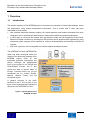
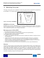
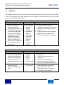
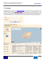
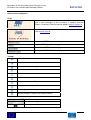
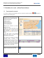
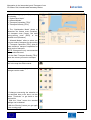
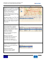
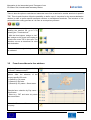
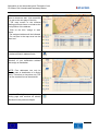
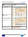
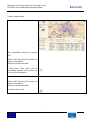
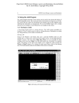
INtegration in the intermodal goods Transport of non EU states: Rail, Inland/coastal waterway Modes interim INTERIM Integration in the intermodal goods transport of non EU states: Rail, inland/coastal waterway modes interim Report WP 3 Development of IT-instruments for the information chain Report WP 3.5 User Manual Date: 21.04.2008 Release: final Worked out by: TFH Wildau – University of Applied Sciences Wildau, Germany 1 INtegration in the intermodal goods Transport of non EU states: Rail, Inland/coastal waterway Modes interim Content: 1 Overview................................................................................................................... 3 1.1 Introduction ...................................................................................................................3 1.2 Methodology / User groups........................................................................................... 4 1.3 Objective....................................................................................................................... 5 1.4 Constraints and requirements....................................................................................... 6 2 Homepage ................................................................................................................ 7 3 Calculation of a route – without fixed relations ................................................... 9 3.1 From terminal to terminal .............................................................................................. 9 3.2 From free address to free address.............................................................................. 16 4 Calculation of a route – with fixed relations ....................................................... 18 5 Analysis of accessibility....................................................................................... 22 6 Glossary ................................................................................................................. 25 7 Figures.................................................................................................................... 28 2 INtegration in the intermodal goods Transport of non EU states: Rail, Inland/coastal waterway Modes interim 1 Overview 1.1 Introduction The specific objective of the INTERIM project is to improve the cohesion of intermodal networks, actors and approaches using spatial development instruments. Thus a model with IT tools has been elaborated to demonstrate with selected intermodal transport chains (rail, inland waterway and harbour-hinterland) how such integration can be implemented with respect to intermodal markets and spatial development, in which way to overcome the existing time gap between today and the integration of the SouthEastern European countries by showing how this process can be prepared and organised by using intermodal goods transport as an example for common implementation and learning in the field of logistics, how such a process can be integrated into national spatial development plans The INTERIM-Tool Sets (INTERIM-TS) which has been developed within the context of the third work package of the INTERIM project focus on two intermodal platforms (description see below). Although the geographical focus of the project is on Central and South-Eastern Europe, the IT tool covers the area of almost whole of Europe. Countries which are not yet considered are e.g. Iceland, Russia, Belarus, Ukraine, Turkey and the Caucasian region. A general overview of the basic structure of the IT tool is given in the figure on the right side which shows the structure of the INTERIM-Tool Set. Figure 1: System Structure of INTERIM-Tool Set 3 interim INtegration in the intermodal goods Transport of non EU states: Rail, Inland/coastal waterway Modes 1.2 Methodology / User groups The Users of the system can be separated in three main groups which are essential for programming the INTERIM-TS. The following figure gives an overview of the main user groups. No restrictions INTERIM Service Provider Accessibility Main target groups of A2A and B2B Observers Figure 2: User Groups of INTERIM-TS Access to the system INTERIM Service Provider INTERIM Service Provider (INTERIM-SP) is the University of Applied Sciences Wildau (TFH Wildau) which is operating the system. The TFH Wildau is authorized to run analyses on data in the system in order to optimize the provision and exchange of information. Main target groups of A2A and B2B - A: The A2A User group aims at main groups like Administrations and agencies (national, regional and local level representatives) Observers (students, private consultancies, citizens). - B: The B2B tool aims at main groups like Logistics Chain Organizer (LCO) who have the task to organize the transport of cargo from Source S to Destination D. Logistics Service Provider (LSP) which is a unit that offers logistics services (e.g. providers of transport services on rail, inland waterways and short sea shipping, providers of transhipment services, providers of additional logistics services). The geographical competence (GC) has to be at least in part within the boundaries of the INTERIM area. Customers of the LCO and LSP who want to send goods from Source (S) to Destination (D) Observers This group uses the system to get information about intermodal transport chains. Via the B2B view the observer gets easily detailed information about the operating LCO / LSP, operating days and different routes which are possible (including use of GIS module), etc. Additionally the observer is able to retrieve information about activities and strategies of regional development agencies and planning authorities via external links. General information regarding intermodal transports and spatial planning is available, especially concepts of the European Union. 4 INtegration in the intermodal goods Transport of non EU states: Rail, Inland/coastal waterway Modes 1.3 interim Objective The following figures give an overview of the current problems which the future users of the INTERIMTS face. It is the objective to create benefits which will be given by the INTERIM-TS. The main benefits are also described in the figures below. A2A Problem The deficient contact between the different planning institutions The deficient knowledge of the intermodal transport and the involved infrastructure The deficient knowledge about the EU and national spatial planning aims, systems and regularities Spatial “bottlenecks” for cross-border development due to different territorial governance User group A2A experts: Development agencies, planning authorities, international, national, regional and local public organized agencies, private organized agencies Benefit The access and exchange of information and the widen of knowledge concerning the intermodal transport and spatial planning will be possible To get a general but also a possible detailed overview of the involved infrastructure and added parameters Figure 3: Problems and benefits of the A2A User group B2B Problem Deficient knowledge about the involved infrastructure (e.g. current bottlenecks) Deficient knowledge about possible partners in the intermodal transport sector User group Logistics Chain Organizer (LCO), Logistics Service Provider (LSP) Deficient access to the intermodal market Deficient knowledge about offers Customers of LCO and LSP Figure 4: Problems and benefits of the B2B User group 5 Benefit Information about infrastructure will be provided Possibility to present skills and competences Schedules can be presented Fast access to current information Contacts to interesting occurring LSP Fast overview of the intermodal transport market out of one hand Query concerning a certain transportation order can be set up Fast contact to LSP and LCO INtegration in the intermodal goods Transport of non EU states: Rail, Inland/coastal waterway Modes 1.4 interim Constraints and requirements Conceptual constraints It is assumed that routes which are included in time table of regular traffic and traffic on demand in the context of intermodal transportation are deposited in the system. Special traffic or ad hoc traffic can not be considered in the system. In general the availability of data may be another conceptual constraint. Geographical constraints The INTERIM IT tool covers not only the INTERIM project area (Germany, Austria, Croatia, Serbia, Rumania and Bulgaria) as part of the CADSES area, but almost whole of Europe. Countries which are not yet considered are Iceland, Russia, Belarus, Ukraine, Turkey and the Caucasian region. Security requirements The admission to the INTERIM-TS will be given after filling in a registration form via the internet and the transmission to the administrator. Information like company / department name, contact person, address and email are compulsory to get an account. It is intended to generate the password automatically which means that it will be transmitted automatically to the prospective user. User interface requirements - So far the INTERIM-TS have been developed with an English language user interface. - To avoid barriers concerning the usage of the INTERIM-TS no submission of installation files or executable files to potential users are necessary. - The GIS data for the INTERIM-TS are interactive (i.e. linking selected elements in tables with their display in maps and vice versa). - The buttons, icons and fields of the tool contain an explanation of the context (mouse over for approx. 1 sec.). Most functions provided in the system are self explaining, so that this user manual could be kept to a minimum. Nevertheless an online help is planned to be offered for features that require some more explanations. General information A central organised server solution has been provided. The central server is hosted at the TFH Wildau where the INTERIM-SP is operating the system. The system is internet based and the accessibility to the INTERIM-TS is possible with a common Internet Explorer. 6 INtegration in the intermodal goods Transport of non EU states: Rail, Inland/coastal waterway Modes interim 2 Homepage The INTERIM IT tool is hosted on www.viom.de/interim. A link to the IT tool is also provided on the INTERIM project homepage www.interim-online.eu (entry: Routing tool). To get access to the IT tool you have to register. User name and password are available from the administrator. After you have received your user name and your password, please enter on the homepage of the INTERIM tool your user name in the field “User” and your password in the field “Password”. Then press the login button. You come to the following start page 7 INtegration in the intermodal goods Transport of non EU states: Rail, Inland/coastal waterway Modes interim General menu navigation: Links: Link to the homepage of the University of Applied Sciences Wildau (Technische Fachhochschule Wildau) www.tfh-wildau.de Link to www.viom.de Link to the INTERIM project web page Link to INTERIM project news page Link to the INTERIM disclaimer page Link to the INTERIM Member-Login page Toolbar: Return to previous map view Step forward to next map view Navigate to the map’s origin Zoom in Zoom out Zoom out for quick orientation Toggle pan mode on/off Distance measuring on/off Print map cutout Maximize applet / reinsert into browser window 3D-view Show / hide navigable overview window Zoom to selected local position 8 INtegration in the intermodal goods Transport of non EU states: Rail, Inland/coastal waterway Modes interim 3 Calculation of a route – without fixed relations 3.1 From terminal to terminal If you want to calculate an intermodal route from a terminal to another terminal described in the following steps Select a given terminal from the terminal list through one of the following options: a.) Filter by country-specific ISO code b.) Filter by city name c.) Filter by name d.) Filter by Zip code d.) Filter by street name e.) Filter by description Example here: selection by countryspecific ISO code - Select e.g. “GB” and click on the terminal you want to choose as start. (Use eventually to get to the next page of the list or to get to the end of the list) - The map zooms to the selected terminal and shows a red star at the local position of the terminal The terminal list contains all relevant information about a terminal / TSP (transhipment point). The user can sort the table by Name, Description, Country, ZIP code, City name, Street name or Geo code through clicking on the header of each column. The list will be sorted in alphabetic order or vice versa. The link in the Column “Info” leads to detailed information about the TSP 9 , proceed as INtegration in the intermodal goods Transport of non EU states: Rail, Inland/coastal waterway Modes Example: Aalborg The link in the Column “LSP” leads to a list of Logistics Service Provider running to and from the TSP Example: LSP for Aalborg Click after the selection of a TSP on the blue ”assign to start” button 10 interim INtegration in the intermodal goods Transport of non EU states: Rail, Inland/coastal waterway Modes The name of the assigned terminal will be indicated. The red star in the map turns into the “start icon”. Repeat the same procedure for the selection of your destination and click on the blue ”assign to destination” button The name of the assigned terminal will be indicated. The red star in the map turns into the “destination icon”. Optional: Repeat the same procedure for the selection of one or two via-points and click on the blue ”assign to via1” / ”assign to via2” button (see more details at the end of this chapter) Press the “Routing” button to get to the routing page 11 interim INtegration in the intermodal goods Transport of non EU states: Rail, Inland/coastal waterway Modes On the following page specify your query by selecting 1. “Optimization Mode” 2. “Allowed Modes” 3. “Transport Capacities (TEU)” 4. “Transport Quantity (TEU)” 1. The “Optimization Mode” allows to determine the fastest route (Duration), the cheapest route (Costs), the most energy-saving route (ECO) or the shortest route (Distance) 2. “Allowed Modes” allow to select one or more mode of transport for the routing 3. “Transport Capacities (TEU)” allow to state maximum transport capacities for each mode of transport NOTE: Changes are only recommended for experienced users! 4. In the field “Transport Quantity (TEU)” enter the volume you want to transport Press “Show routing points” in order to see in the map the area covered - If buttons are in grey colour, no changes can be made. - If changes concerning the selection of the terminals have to be done, use the button “Terminals” to get back to the terminal list - With the “Clear” button the terminal settings can be deleted - With the “Routing” button you get again to the routing page 12 interim INtegration in the intermodal goods Transport of non EU states: Rail, Inland/coastal waterway Modes interim - Press the “Start query” button to start the routing process Main calculating operations: GIS based generation and display of intermodal transport routes on the basis of underlayed networks (road, rail, inland waterway, transhipment terminals) and according to defined criteria and transport requirements (Basic function) Parallel calculation and comparison of route alternatives by the criteria distance, time, costs and energy consumption (Alternative Routes function) Calculation of up to 2 defined via-points for the sourcedestination relation in case of selection of preferred specific transport corridors or transhipment terminals (Via-point function) Presentation of information (contacts, service portfolio) of suitable logistics service providers (e.g. special provider for inland navigation) and transhipment terminals for each part of the generated transport chains (Information function) - If a routing request has already be done, the last result can be displayed by pressing the button “Show last result” The next page shows the routing result based on the chosen optimization mode: The following information for the whole transport chain as well as for individual routing segments are available: - Quantity to be transported - Duration - Distance - Energy consumption - Costs A segment is a section from one TSP to another TSP without changing the mode of transport If changes e.g. concerning the selection of optimization mode, mode of transport or quantities etc. have to be done, use the blue button “Back” to get back to the routing page 13 INtegration in the intermodal goods Transport of non EU states: Rail, Inland/coastal waterway Modes Geographical details of the routing segments can be displayed in the map through the selection of an individual segment in table “Routing Segments”: 1. Click on routing segment 2. Map zooms to the segment 3. Chosen segment turns into red colour 4. Segment details change (in the table “Segment Details”) Geographical details of the TSP of the chosen routing segment can then be displayed through selection of a terminal name in the table “Segment Details” on the right side Sequence of columns: - Name of Start TSP of a segment - Name of End TSP of a segment - Mode of transport within the segment - Transport volume/quantity in segment - Duration per segment - Distance per segment - Energy Consumption per segment - Costs per segment Table “Routing Segments” Sequence of row entries: - From Start TSP to TSP (segment 1) - From TSP to TSP (segment 2) - From TSP to TSP (segment 3) - From TSP to End TSP (segment 4) Sequence of columns: - Name of TSP of chosen segment - Related Log. Service Provider (LSP) - Type of terminal Table “Segment Details” Sequence of row entries: - Start TSP of chosen segment - End TSP of chosen segment 14 interim INtegration in the intermodal goods Transport of non EU states: Rail, Inland/coastal waterway Modes If the field “Accumulated values” is checked, the transport costs for the total number of TEU will be evaluated (compare entry in the field “Transport Quantity (TEU)” on the routing page) The link in the Column “Typ” leads to detailed information about the selected TSP Example: Budapest Port 15 interim INtegration in the intermodal goods Transport of non EU states: Rail, Inland/coastal waterway Modes interim There is also the option to calculate an intermodal route from a terminal to another terminal via specific TSP. This via-point function offers the possibility to define up to 2 via-points for the source-destination relation in order to prefer specific transport corridors or transhipment terminals. The inclusion of viapoints affect the routing process as it is seen as a compulsory element. - If you are not already on the page showing the terminal list, go to it by pressing the “Terminals icon” - With the blue buttons “assign to via1” and “assign to via2” there is the option to include one or two TSP in the route. The selection occurs as described for start and destination. The name of the assigned via-points will be indicated. 3.2 From free address to free address Beginning from the start page, click on the button ”Address search” To search an address there are several options. After the selection of the country-specific ISO code a.) Search by City name b.) Search by Zip code c.) Search by City name + Street name Example here: selection by City name + Street name - Select e.g. “DE” and enter city name and street name. Press the “Start search” button to start the query 16 INtegration in the intermodal goods Transport of non EU states: Rail, Inland/coastal waterway Modes - Then click on the address line you want to choose as start. (Use eventually to get to the next page of the list) - The map zooms to the selected starting point and shows a red star at the local position of the address - Click on the blue ”assign to start” button - The assigned address will be indicated. - The red star in the map turns into the “start icon” Press the “Clear search” button in order to delete all filled in address fields Then repeat the same procedure for the selection of your destination address and assign to destination NOTE: Free addresses can only be used as start or destination of a routing query. Therefore as via-points only TSP from the terminal list can be selected. Press the “Routing” button to get to the routing page and continue as already described in the previous chapter 17 interim INtegration in the intermodal goods Transport of non EU states: Rail, Inland/coastal waterway Modes interim 4 Calculation of a route – with fixed relations The INTERIM IT tool offers the possibility to include fix relations in the routing process. Fix relations are relations where intermodal service offers already exist and which will be run by a transport operator. The routing taking into account the existing market offer will be included as backbone. That means it serves as main run for the complete and entire routing process. The calculation of a route with fix relations can be realised after the determination of a start and destination (either terminal and/or free address). Example: Kiel (DE) – Debrecen (HU) After the assignment of a start and a destination as described in the previous chapters, press the button ”Fix relations” You get to the page as pictured on the right - Press the red button “Search fix relations between Start and Destination” 18 INtegration in the intermodal goods Transport of non EU states: Rail, Inland/coastal waterway Modes NOTE: The default setting of the search for fix relations is within a radius of 300km from a Start or Destination. If no values were found increase the radius Results at radius 300km: NOTE: If no fix relation is suitable, increase the radius again to get further options for fix relations. Select from the list a fix relation by clicking on the relation. (Use eventually to get to the next page of the list) The selected fix relation turns into white colour Press the arrow “Assign fix relations between Start and Destination” 19 interim INtegration in the intermodal goods Transport of non EU states: Rail, Inland/coastal waterway Modes The fix relation is assigned when it turns into red colour The name of the company (if available) which operates the chosen fix relation will be indicated - The links in the Column “Info” lead to detailed information about the fix relation Example: fix relation of intercontainer An assigned fix relation can be removed by pressing the button “Clear fix relations between Start and Destination” Press the button “Routing” to get to the routing page and continue as already described previously (individual settings) Then press the “Start search” button to start the query 20 interim INtegration in the intermodal goods Transport of non EU states: Rail, Inland/coastal waterway Modes The chosen fix relation is considered in the further routing process 21 interim INtegration in the intermodal goods Transport of non EU states: Rail, Inland/coastal waterway Modes interim 5 Analysis of accessibility The INTERIM IT tool offers the possibility to analyse the accessibility of transhipment points regarding criteria like duration, distance, costs and energy consumption. The accessibility analysis can be realised after the determination of a start (TSP). The additional selection of a destination is optional. After the assignment of a start (and optional of a destination) as described previously, press the button ”Region” If you want to start the accessibility analysis from your chosen start, click the button “Zoom to start” If you want to start the accessibility analysis from a chosen destination, click the button “Zoom to destination” You get to the page as shown on the right Select an optimization mode: - Duration - Distance - Energy consumption (ECO) - Costs Example here: Duration 22 INtegration in the intermodal goods Transport of non EU states: Rail, Inland/coastal waterway Modes Enter a maximum value as basis for the analysis Start query NOTE: The higher the entered value, the more time needs the evaluation process (exponential progression) The next page lists the results of the accessibility analysis based on chosen optimization mode and maximum value. The map pictures the results isochrones: - value of outer line = 100% - value of middle line = 66% - value of inner line = 33% as All terminals will be indicated which can be reached within the requested time (or if chosen as optimization mode within the requested distance, costs or energy consumption) Press on the blue stars in the map in order to receive detailed TSP information Example: Leipzig-Wahren 23 interim INtegration in the intermodal goods Transport of non EU states: Rail, Inland/coastal waterway Modes Further possible steps Possibility 1: New accessibility analysis for another TSP Select a TSP from the list of results and assign as destination Example: Dresden-Neustadt - Press again “Start query” and the accessibility analysis will be carried out for the chosen destination Possibility 2: Select a TSP from the list of results and assign as destination Example: Dresden-Neustadt - Continue with routing 24 interim INtegration in the intermodal goods Transport of non EU states: Rail, Inland/coastal waterway Modes interim 6 Glossary Term Explanation A A2A experts Development agencies, planning authorities, international, national, regional and local public organized agencies, private organized agencies A2A tool The A2A tool (Administration to Administration) is one of the two IT tools that has been developed during the INTERIM project. Regional development agencies and planning authorities obtain the possibility to provide and exchange information regarding intermodal transport modes and their impacts to regional development plans using GIS technology and impact evaluation features. B B2B tool The B2B tool (Business to Business) is one of the two IT tools that has been developed during the INTERIM project. Operators, forwarders and shippers (mainly small and mediumsized enterprises) obtain the possibility to provide and exchange information regarding offers and demands of intermodal transports and contacts, capacities, technical requirements and constraints. Bottleneck Overloaded segment or point/node (e.g. border crossing point). Bottlenecks are specially marked in the GIS mode and additional data (e.g. average waiting time) are shown D Destination (D) Destination of cargo E Element Elements of a logistics chain. Collective term for segments and nodes. F Fix relation Relations where intermodal service offers already exist and which will be run by a transport operator G GIS Geographical Information Systems are both, hard- and software systems, for saving, filtering, analyzing and also managing data which allow a spatial relatedness. Within GIS geographical data are combined with informational data 25 INtegration in the intermodal goods Transport of non EU states: Rail, Inland/coastal waterway Modes interim Term Explanation GIS data Collective term for all map, network and location data that are basic data of the GIS module Geographical area, in which the LSP offers the logistics services Geographical Competence (GC) I INTERIM-SP INTERIM-Service Provider: Is operating the INTERIM system INTERIM-TS INTERIM-Tool Sets, preliminary name of the INTERIM IT system (consisting of Toolsets A2A and B2B) L Logistics Chain Describes the transport route the box (with cargo) takes from Source S to Destination D. The logistics chain consist of segments (S1 to Sn) with Transhipment points (T1 to Tn) in between. Example: S Î S1 Î T1 Î S2 Î T2 Î S3 Î D LCO Logistics Chain Organizer; Person/Organizational unit, that is tasked to organize the complete logistics chain from Source to Destination LSP Logistics Service Provider; Collective term of providers of logistics services, that are represented in the INTERIM system and area (LSP) M Mode of transport Rail, Inland Waterways, Short Sea Shipping Routes N Node Element of the logistics chain marking start and end of a segment. In general transhipment of cargo takes place at a node. Q Query Query addressed to the system (access to data base) based on user input Query result Result of query that is presented to the user by the system S Segment Section from one TSP to another TSP without changing the mode of transport Start (S) Starting point of cargo e.g. location of consigner T Time table Time table of a planned transport executed by a transport operator Transport operator Provider of cargo transport services (all modes of transport) TSP Transhipment point 26 INtegration in the intermodal goods Transport of non EU states: Rail, Inland/coastal waterway Modes Term interim Explanation U User User of the INTERIM system User group Group of users of the INTERIM system with rights assigned according to their role of using the system i.e.: INTERIM-SP Logistics Chain Organizers (LCO) Logistics Service Providers (LSP) Observer Administrator V Via-point TSP between Start and Destination which will be served. Viapoints for the source-destination relation can be selected in order to prefer specific transport corridors or transhipment terminals. 27 INtegration in the intermodal goods Transport of non EU states: Rail, Inland/coastal waterway Modes interim 7 Figures Figure 1: System Structure of INTERIM-Tool Sets .................................................................... 3 Figure 2: User Groups of INTERIM-TS ...................................................................................... 4 Figure 3: Problems and benefits of the A2A User group............................................................ 5 Figure 4: Problems and benefits of the B2B User group............................................................ 5 28