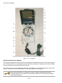
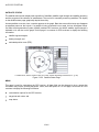
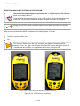
1
A-CR-CCP-703/PF-001
CHAPTER 13
PO 322 – PLOT LOCATION ON A TOPOGRAPHICAL MAP
USING A GLOBAL POSITIONING SYSTEM RECEIVER
A-CR-CCP-703/PF-001
ROYAL CANADIAN ARMY CADETS
SILVER STAR
INSTRUCTIONAL GUIDE
SECTION 1
EO M322.01 – REVIEW RED STAR NAVIGATION
Total Time:
30 min
PREPARATION
PRE-LESSON INSTRUCTIONS
Resources needed for the delivery of this lesson are listed in the lesson specification located in A-CR-CCP703/PG-001, Chapter 4. Specific uses for said resources are identified throughout the instructional guide within
the TP for which they are required.
Review the lesson content and become familiar with the material prior to delivering the lesson.
PRE-LESSON ASSIGNMENT
Mark off 100 m for pacing.
APPROACH
An interactive lecture was chosen for this lesson to review the basic and background material covered during
Red Star navigation.
INTRODUCTION
REVIEW
N/A.
OBJECTIVES
By the end of this lesson the cadet shall have reviewed Red Star navigation, to include:
describing bearings;
identifying compass parts;
setting declination;
determining distance on a map;
determining individual pace;
orienting a map using a compass; and
taking a magnetic bearing using a compass.
13-1-1
A-CR-CCP-703/PF-001
IMPORTANCE
It is important for cadets to participate in a review of Red Star navigation as it is a foundation for building
subsequent navigation skills. The review will clarify any areas in question, providing an opportunity for cadets to
work on their skills and retard progressive skill decay. Red Star navigation is an important aspect of expedition
training and before learning new skills, the skills already taught should be reviewed. All cadets should take
every opportunity to practice and refine these skills.
Teaching Point 1
Conduct a Review of Red Star Navigation
Time: 25 min
Method: Interactive Lecture
Briefly review Red Star navigation without spending too much time on any one point.
POINTS OF THE COMPASS ROSE
Four Cardinal Points. Measured at right angles clockwise, they are:
1.
north (N),
2.
east (E),
3.
south (S), and
4.
west (W).
Four Inter-Cardinal Points. Located halfway between each of the cardinal points. Measured clockwise, they
are:
1.
northeast (NE),
2.
southeast (SE),
3.
southwest (SW), and
4.
northwest (NW).
Eight Intermediate Points. Located halfway between each cardinal point and inter-cardinal point. Measured
clockwise, they are:
1.
north-northeast (NNE),
2.
east-northeast (ENE),
3.
east-southeast (ESE),
4.
south-southeast (SSE),
5.
south-southwest (SSW),
13-1-2
A-CR-CCP-703/PF-001
6.
west-southwest (WSW),
7.
west-northwest (WNW), and
8.
north-northwest (NNW).
Director Cadets 3, 2007, Ottawa, ON: Department of National Defence
Figure 13-1-1 Compass Rose
SCALES ON A COMPASS
To express direction in an accurate and precise method, the full circle of the compass rose is divided into equal
measures of angle. This measurement starts and ends at north (top) and always moves in a clockwise rotation.
There are two main scales used to measure a circle – degrees and metric milli-radian (mils).
Degrees. The most common method of dividing a circle. There are 360 equal angles in a complete circle and
they are represented by the degree symbol (eg, 360°). On the compass rose, north is located at 0 and 360
degrees, east is located at 90 degrees, south is located at 180 degrees and west is located at 270 degrees.
Mils. When a more accurate division of the same circle is required, the mils method is used. The mils method
has a military background and is based on the metric system with 6400 equal angles in a complete circle. On
the compass rose, north is located at 0 and 6400 mils, east is located at 1600 mils, south is located at 3200
mils and west is located at 4800 mils.
There are 22.5 degrees or 400 mils between each point on a compass rose.
13-1-3
A-CR-CCP-703/PF-001
DEFINITION OF A BEARING
Bearing. An angle that is measured clockwise, from a fixed zero line; north is always this zero line. Simply, a
bearing is just another name for an angle.
TYPES OF BEARINGS
Bearings are divided into three different types:
Grid Bearing. A bearing that is measured between two points on a map. The ability to measure a bearing from
a map allows a map user to plan routes or activities before going into the field, and provides an easy method
of communicating location or movement.
Magnetic Bearing. A bearing that is measured between two points using a compass. A magnetic bearing is a
quick and efficient method of describing a route to take. The bearing alone is usually not enough information
to navigate with and must also have distance or a target object.
Back Bearing. A bearing that is in the exact opposite direction of the bearing that has been measured. A back
bearing can be useful for different reasons; to return to the start location after a hike, or to calculate the bearing
from an object to one’s current location. Depending on the compass being used, the steps to calculate a back
bearing are:
1.
When the bearing is less than 3200 mils or 180 degrees, add 3200 mils or 180 degrees.
2.
When the bearing is greater than 3200 mils or 180 degrees, subtract 3200 mils or 180 degrees.
COMPASS PARTS
Refer to Figure 13-1-2 or an actual compass to identify the parts of a compass with the
cadets.
A - Sight. Located at the top of the compass cover, used to align an objective or bearing.
B - Compass Cover. Protects the compass dial and houses the sighting mirror.
C - Sighting Mirror. Used to see the compass dial while setting a bearing.
D - Sighting Line. Used when aligning the objective or bearing.
E - Luminous Index Point. Located at the top of the compass dial and is where a bearing is set and read from.
F - Compass Dial. Houses the magnetic needle, the orienting arrow and the declination scale on the inside
and the dial graduations on the outside.
G - Dial Graduations. The compass dial is graduated in 50 mil divisions from 0 to 6400 mils, or two degree
divisions from 0 to 360 degrees. The dial is rotated by hand.
H - Orienting Arrow. The red orienting arrow is located inside the compass dial and is used to line up the
magnetic needle. The orienting arrow is always set at 00 mils/degrees.
I - Romer 1 : 25 000. Used to measure a grid reference (GR) on a map with a 1 : 25 000 scale.
J - Compass Base Plate. Clear piece of flat plastic, to which the cover, dial and lanyard are attached.
13-1-4
A-CR-CCP-703/PF-001
K - Declination Scale. Used to compensate for the variation of magnetic declination between the compass
and the map being used.
L - Compass Meridian Lines. Black or red lines inside the compass dial and are used to line up the compass
dial with the grid lines on a map.
M - Magnetic Needle. Spins freely and points to magnetic north. The south end of the compass needle is black
and the north end, with a luminous patch, is red. When the magnetic needle is lined up with the red orienting
arrows, the mnemonic “Red in the Bed” is used to remember which end of the needle belongs between the
arrows.
N - Luminous Orienting Points. There are two luminous orienting points located on either side of the orienting
arrow.
O - Luminous Index Point. The luminous orienting point at the bottom of the compass dial, where a back
bearing is read from.
P - Romer 1 : 50 000. Used to measure a GR on a map with a 1 : 50 000 scale.
Q - Safety Cord or Lanyard. Used to fasten the compass to the body.
R - Adjustable Wrist Lock. Used to attach the compass to the wrist.
S - Screwdriver. The tiny screwdriver at the end of the safety cord is used to turn the screw to adjust the
declination scale.
T - Declination Adjustment Screw. Located on the back side of the compass dial and is used to adjust the
declination scale (not shown).
13-1-5
A-CR-CCP-703/PF-001
A-CR-CCP-121/PT-001, Royal Canadian Army Cadet Reference Book (p. 5-33)
Figure 13-1-2 Compass
SET DECLINATION ON A COMPASS
The compass’s declination scale must be set to compensate for the difference between true north and magnetic
north. To set declination on a compass the amount of declination adjustment in degrees east or west is needed.
Turn the compass over and look at the back of the dial.
From the zero point, use the screwdriver on the end of the safety cord and turn the declination screw to the
right for west and to the left for east declination. Each small black line is two degrees.
When setting declination on a compass, it is easier to hold the screwdriver and turn the
compass, especially in cold weather. The declination shall never be turned past 90 degrees
on the declination scale.
13-1-6
A-CR-CCP-703/PF-001
Director Cadets 3, 2007, Ottawa, ON: Department of National Defence
Figure 13-1-3 Declination Screw
DETERMINE DISTANCE
Determining Distance on a Map
Cadets can use their maps to measure the distance between two points on the ground. All maps are drawn
to scale; therefore, a specified distance on a map equals a specified distance on the ground. The scale of a
map is printed at the top and bottom of each map (eg, Scale 1 : 50 000). This means that 1 cm on the map
equals 50 000 cm (500 m) on the ground.
There are two ways to determine distance on a topographical map – point-to-point and along a route.
Measuring Point-to-Point. To measure a distance point-to-point:
1.
Lay the straight edge of a piece of paper against the two points.
2.
With a sharp pencil, mark the paper at the A (start) and B (finish) points.
3.
Lay the paper just under the scale bar (metres) and move the B mark backwards to each thousands mark
until the A mark falls within the subdivided thousands (hundreds) to the left of the zero.
4.
To calculate the total distance, add the number of thousands where the B mark is, plus the number of
subdivided thousands where the A mark is to the left of the zero.
13-1-7
A-CR-CCP-703/PF-001
A-CR-CCP-121/PT-001 (p. 5-24)
Figure 13-1-4 Measuring Distance Point-to-Point
A-CR-CCP-121/PT-001 (p. 5-25)
Figure 13-1-5 Calculating Distance
For a distance that is longer than 5 000 m, measure the first 5 000 m and mark the paper
with a new line and label it ‘5 000 m’. Place the new mark at the zero or thousands mark
until the A mark fits within the subdivided thousands bar. Add the total of that distance to the
5 000 m and that will be the total distance.
Measuring Along a Route. Sometimes the cadets need to find the distance between A and B around curves
in a road or along a planned route. To measure a distance along a route between two points:
1.
Lay the straight edge of a piece of paper against point A.
2.
With a sharp pencil, mark point A on the paper and the map.
3.
Line up the paper with the edge of the road until you come to a curve and make another mark on the
paper and on the map.
4.
Pivot the paper so that it continues to follow the road edge. Repeat until you reach point B.
13-1-8
A-CR-CCP-703/PF-001
5.
Mark your paper and the map at point B.
6.
Lay the paper just under the scale bar (metres) and move the B mark backwards to each thousands mark
until the A mark falls within the subdivided thousands to the left of the zero.
7.
Adding the number of thousands where the B mark is, plus the number of subdivided thousands where
the A mark is to the left of the zero, will determine the total distance.
A-CR-CCP-121/PT-001 (p. 5-25)
Figure 13-1-6 Measuring Distance Along a Route
Determining Individual Pace
Pace Counting Method (Pacing). Used for measuring a given distance by counting every other step. Two steps
equal one pace. Pacing is a very important skill in navigation, as each person has a different pace and needs
to establish their pace before it can become a useful measurement tool. Pacing varies between individuals as
it uses a natural stride – an average adult will pace about 60–70 paces in 100 m.
To determine an individual pace, practice taking uniform, comfortable steps over a measured distance (100 m)
counting every second step of the dominant foot. Do this three to five times to get an average. This will be the
individual’s pace number and should be remembered.
13-1-9
A-CR-CCP-703/PF-001
B. Kjellstrom, Be Expert with Map & Compass, Hungry Minds, Inc. (p. 53)
Figure 13-1-7 Determining Distance Using Pacing
Remember, pacing is an approximation. A margin of error of 1–2 percent is considered
reasonable (eg, 10–20 m for every 1 km walked).
Factors That Affect Pacing
Pacing can be affected by different factors and the count may vary. Some of the factors and the affect on
individual pacing are:
Topography. This is the most common factor. Walking through mud, thick bush and tall vegetation can
shorten the paces.
Slopes. Walking uphill will shorten paces, while walking downhill can lengthen paces.
Fatigue. Pacing may change from natural in the morning, when cadets are rested, to shorter in the
afternoon as they start to get tired.
Equipment. Equipment could affect pacing, such as the wrong type of footwear. Too much or too little
clothing and the amount of equipment being carried can shorten the paces.
Weather. Heavy rain, wind velocity, temperature and snow can shorten the paces.
Pacing beads can be used to keep track of the distance walked. One bead is moved for
every 100 m walked. If pacing beads are not available, stones can be used by moving them
from one pocket to another to count every 100 m.
13-1-10
A-CR-CCP-703/PF-001
ORIENT A MAP USING A COMPASS
To orient a map using a compass:
1.
set the current declination on the compass;
2.
set the compass dial to read 00 (zero) mils or 0 degrees (north);
3.
lay the compass flat on the map with the cover open;
4.
point the mirror to north (top of the map);
5.
align one side of the base plate with an easting line; and
6.
turn the map and compass together until the red end of the magnetic needle is over the orienting arrow.
The mnemonic used to remember putting the magnetic needle over the orienting arrow is
“Red in the Bed”.
Director Cadets 3, 2007, Ottawa,
ON: Department of National Defence
Director Cadets 3, 2007, Ottawa,
ON: Department of National Defence
Figure 13-1-8 Set Declination
Figure 13-1-9 Set Compass to 00
Director Cadets 3, 2007, Ottawa,
ON: Department of National Defence
Figure 13-1-10 Turn
Until Red is in the Bed
TAKE A MAGNETIC BEARING
A compass can be used to identify the cardinal points such as north and south, the direction of travel and the
bearing from one’s current location to a prominent object. However, the ability to take a magnetic bearing of
a prominent object and to use that information to help identifying one’s general location can save hours when
trekking. A magnetic bearing is a quick method for determining the direction of travel.
13-1-11
A-CR-CCP-703/PF-001
There are two ways to determine a magnetic bearing.
To determine the magnetic bearing of a prominent object:
1.
Check and set the predetermined declination on the compass.
2.
Hold the compass at eye level, at arms length, and face the prominent object.
3.
Aim at the object using the compass sight, ensuring the sighting line is in line with the index pointer.
4.
Adjust the compass cover so the compass dial is seen in the sighting mirror.
5.
Look in the mirror and turn the compass dial until the magnetic needle is over the orienting arrow (red
in the bed).
6.
Read the number on the compass dial at the luminous index pointer. The magnetic bearing of the prominent
object is read at the luminous index pointer.
A-CR-CCP-121/PT-001 (p. 5-42)
Figure 13-1-11 Taking a Magnetic Bearing
To determine a magnetic bearing on a map:
1.
Set the predetermined declination on the compass.
2.
Identify and mark the start (point A) and finish (point B) points on a map.
3.
Draw a plotting line from point A to point B.
4.
Lay the fully opened compass with the edge of the compass base plate along the plotting ray, in the
direction of travel (point A to point B).
5.
Hold the compass in place, rotate the compass dial so that the compass meridian lines align with the
easting lines on the map, ensuring north on the dial indicates north on the map.
6.
Read the number on the compass dial at the luminous index pointer.
13-1-12
A-CR-CCP-703/PF-001
Prior to determining a magnetic bearing on a map, it is good practice to first estimate the
bearing by drawing a quick compass rose and looking at where the bearing would be on
the compass rose. This serves as a good check to ensure the cadet has not accidentally
measured the back bearing.
If the bearing is taken from point B to point A, the compass will be pointing 180 degrees or
3200 mils in the exact opposite direction of travel wanted. This is also called a back bearing.
CONFIRMATION OF TEACHING POINT 1
The cadets’ participation in the review will serve as the confirmation of this TP.
END OF LESSON CONFIRMATION
The cadets’ participation in the review will serve as the confirmation of this lesson.
CONCLUSION
HOMEWORK/READING/PRACTICE
N/A.
METHOD OF EVALUATION
N/A.
CLOSING STATEMENT
Map-reading skills take a great deal of practice in order for a person to become efficient using them in the field.
Throughout expeditions, cadets will always be required to navigate routes. Take each and every opportunity
to practice map and compass skills, whether it is navigating a route or even riding a bike. The skills learned in
Green and Red Star navigation are building blocks. There are still many more navigation skills to acquire.
INSTRUCTOR NOTES/REMARKS
Assistant instructors may be required for this lesson.
REFERENCES
A2-041
B-GL-382-005/PT-001 Canadian Forces. (2006). Maps, Field Sketching, Compasses and the
Global Positioning System. Ottawa, ON: Department of National Defence.
C0-011
Canadian Orienteering Federation. (1985). Orienteering Level Two Coaching Certification.
Ottawa, ON: Canadian Orienteering Federation.
C2-041
(ISBN 0-07-136110-3) Seidman, D., & Cleveland, P. (1995). The Essential Wilderness Navigator.
Camden, ME: Ragged Mountain Press.
13-1-13
A-CR-CCP-703/PF-001
THIS PAGE INTENTIONALLY LEFT BLANK
13-1-14
A-CR-CCP-703/PF-001
ROYAL CANADIAN ARMY CADETS
SILVER STAR
INSTRUCTIONAL GUIDE
SECTION 2
EO M322.02 – CALCULATE MAGNETIC DECLINATION
Total Time:
60 min
PREPARATION
PRE-LESSON INSTRUCTIONS
Resources needed for the delivery of this lesson are listed in the lesson specification located in A-CR-CCP703/PG-001, Chapter 4. Specific uses for said resources are identified throughout the instructional guide within
the TP for which they are required.
Review the lesson content and become familiar with the material prior to delivering the lesson.
Photocopy the handout located at Annex A for each cadet.
PRE-LESSON ASSIGNMENT
N/A.
APPROACH
An interactive lecture was chosen for TP 1 to orient the cadet to calculating magnetic declination and to present
basic material.
Demonstration and performance was chosen for TP 2 as it allows the instructor to explain and demonstrate
calculating magnetic declination while providing an opportunity for the cadets to practice calculating magnetic
declination under supervision.
An in-class activity was chosen for TP 3 as it is an interactive way to reinforce calculating magnetic declination.
INTRODUCTION
OBJECTIVES
By the end of this lesson the cadet shall have calculated magnetic declination.
IMPORTANCE
It is important for cadets to know how to calculate magnetic declination and set it on a compass as it provides the
cadet with confidence that they will arrive at their destination when navigating on a bearing. Not accounting for
declination may affect navigation, as the cadet may travel off route. For every one degree of error in declination
setting, a person would be approximately 52 m off of for every km travelled.
13-2-1
A-CR-CCP-703/PF-001
Teaching Point 1
IAW M222.02 (Describe Bearings) Review Magnetic
Declination and the Three Norths
Time: 5 min
Method: Interactive Lecture
Magnetic declination was identified in M222.03 (Identify Compass Parts, A-CR-CCP-702/
PF-001, Chapter 12, Section 3) however, it must be discussed again to support calculating
magnetic declination.
Magnetic Declination
Magnetic declination is the difference between true north (map) and magnetic north (compass). It is caused
by the different locations of the geographic north pole and the magnetic north pole plus any local anomalies
such as iron deposits.
Map users will identify the declination in the marginal information through a declination diagram depicting the
true, grid, and magnetic bearing of any line within the area of the map sheet.
Declination will change annually due to the shifting magnetic pole. There are only two lines in the northern
hemisphere where magnetic and true north line up equalling declination of zero degrees. One line runs through
central Canada and the other through Russia.
Grid Magnetic Angle
Grid magnetic angle is the horizontal angular difference between grid north and magnetic north. This is the
number that is applied when converting from magnetic to grid bearings.
Annual Magnetic Change
Due to the dynamic forces on the earth, magnetic north continually migrates. Subsequently an annual
adjustment/calculation must be made to obtain the correct grid angle at the date of use. The amount of
adjustment, to be made, is provided in the declination diagram.
This change is significant as adjustments to a compass may be required. This is known as “setting the
declination.” Bearings and directions taken from the map would not be accurate if the magnetic change is not
taken into account. All maps have the required information to calculate the declination and this information is
found in the margin of the map.
Review the three norths. This material was covered in M222.02 (Describe Bearings, A-CRCCP-702/PF-001, Chapter 12, Section 2).
In navigation, there are three different norths – true north, grid north and magnetic north. Each north varies
from each other and must be known for navigation. A diagram representing the three norths can be found in
the margin of the map being used.
13-2-2
A-CR-CCP-703/PF-001
Draw Figure 13-2-1 on a visual aid and draw the symbol for each north as it is explained to
the cadets.
B-GL-382-005/PT-001, Canadian Forces, Maps, Field Sketching, Compasses and the Global Positioning System (p. 51)
Figure 13-2-1 Three Norths
True North. True north is located at the top of the earth where the geographic North Pole is found. It is the
point at which the earth rotates on its axis and is where all lines of longitude meet. In the diagram on the map,
true north is represented by a star (Polaris).
Grid North. Grid north is the north indicated by the grid lines (eastings) on a topographical map. Eastings are
lines that run parallel to each other and will never meet at the North Pole; because of this, grid north points off
slightly from true north. Grid north is symbolized by a square on the declination diagram.
Magnetic North. Magnetic north is the direction in which the compass needle points. This direction is to the
magnetic pole which is located in the Canadian arctic and is slightly different from true north (North Pole).
Magnetic north is symbolized by an arrow or half arrow head on the declination diagram.
CONFIRMATION OF TEACHING POINT 1
QUESTIONS
Q1.
Explain true north.
Q2.
What symbol on a declination diagram represents magnetic north?
Q3.
What is annual magnetic change?
ANTICIPATED ANSWERS
A1.
It is the point at which the earth rotates on its axis. The geographic north pole or true north is located
at the top of the earth where the lines of longitude converge. On a map, the direction of true north is
shown by the lines of longitude. True north is symbolized by a star on the declination diagram.
A2.
Magnetic north is represented by an arrow.
A3.
Due to the dynamic forces on the Earth magnetic north continually migrates. Subsequently an annual
adjustment/calculation must be made to obtain the correct grid angle at the date of use.
13-2-3
A-CR-CCP-703/PF-001
Teaching Point 2
Demonstrate, Explain and Have the Cadet Practice
Calculating Magnetic Declination
Time: 20 min
Method: Interactive Lecture
Provide guidance to the cadets when learning to calculate magnetic declination. Use the
provided steps and follow the sample calculations provided below.
CALCULATE THE MAGNETIC DECLINATION
Locate the Declination Diagram and Information
Calculating current declination uses the information provided by the declination diagram on a map and the
information printed directly underneath. This diagram is most often found, on the right side of the map in the
marginal information.
Calculate Declination
To calculate declination use the angle between magnetic north and grid north – ignoring true north. This is
because bearings taken from a map use grid north as their point of reference. The annual change noted under
the diagram will be either “increasing” (the declination is getting larger), or “decreasing” (getting smaller). The
total annual change will then be added or subtracted from the declination printed on the map, to get the current
declination.
The degree system of bearings shares some structure and terminology with units of time. There are:
360 degrees in a circle, written as 360°,
60 minutes in a degree, written as 60', and
60 seconds in a minute, written as 60".
It is common to divide degrees into minutes, instead of seconds (eg, 1.5' instead of 1'30").
The steps to calculate magnetic declination are:
Step 1. Identify how long it has been since the map information was current by:
1.
Identifying the Current Year. This is the actual current calendar year.
2.
Identifying Year of Declination Information. This date is found under the declination diagram defined
as the “approximate mean declination”.
3.
Recording the Difference in Years. Subtract the approximate mean declination year from the current
year.
Step 2. Determine how much declination has changed since the map was current by:
4.
Multiplying the Difference in Years by the Annual Change. Take the difference in years and multiply
it by the annual change.
Step 3. Update the map declination with the amount of change calculated by:
13-2-4
A-CR-CCP-703/PF-001
5.
Determining if the Annual Change is Increasing or Decreasing. The annual change found under the
declination diagram also indicates whether the annual change is increasing or decreasing in degrees
and minutes.
6.
Adding or Subtracting the Annual Change from the Original Declination. The original declination
is found on the declination diagram. It is the numbers represented in minutes and degrees between grid
north and magnetic north. Were the change is increasing add to the map declination, if the change is
decreasing subtract from the map declination.
Step 4. Set the current declination on the compass by:
7.
Determining if Declination is East or West. This determines what direction the declination must be
set on a compass. East or west is determined by looking at the declination diagram and identifying true
north and magnetic north. The side magnetic north falls on represents east or west declination. Right
side is east, left side is west.
8.
Setting the Calculated Declination on a Compass. On the back side of the compass there is a
declination adjusting screw, adjust the declination adjusting screw to the calculated declination east or
west.
The zero declination line (agonic line) runs west of Hudson Bay, near Churchill, Manitoba.
Therefore, maps east of here can assume a declination to the west and maps west will
assume a declination to the east.
Department of National Defence, Instructional Guide (IG) DP1–Cadet Instructors Cadre (CIC)
Environmental Performance Requirements–Land, Department of National Defence (p. 84)
Figure 13-2-2 Declination Diagram Sample
When the declination is recorded in writing, it is written in degrees and minutes. Degrees is
represented by a number followed by a small circular symbol (eg, 19°) The same is true for
minutes as the number is followed by an apostrophe (eg, 52').
13-2-5
A-CR-CCP-703/PF-001
Example With East Declination (Figure 13-2-2). The declination as of 1991 is 19° 52' East and the annual
change is decreasing 7.0'. The magnetic declination is calculated as:
Current year:
2010
Year of declination information:
- 1991
Difference in years:
19
Difference in years:
19
Annual change:
x 7.0'
Total change:
133' or 2°13'
The total change is converted from 133' minutes to 2°13' because there are 60' in a degree.
Annual change is decreasing so it is subtracted from the original declination:
Original declination:
E 19° 52'
Total change:
- 2° 13'
Current declination:
E 17° 39'
This tells us that the magnetic needle on a compass will point to the east of grid north by 17 degrees and
39 minutes, for the area depicted on this map in 2010.
Department of National Defence, Instructional Guide (IG) DP1–Cadet Instructors Cadre (CIC)
Environmental Performance Requirements–Land, Department of National Defence (p. 84)
Figure 13-2-3 Declination Diagram Sample
13-2-6
A-CR-CCP-703/PF-001
Convert to degrees and minutes when there are 60' (minutes) or more.
Example With West Declination (Figure 13-2-3). The declination as of 1993 is 13° 18' West and the annual
change increasing 1.7'. The magnetic declination is calculated as:
Current year:
2010
Year of declination information:
- 1993
Difference in years:
17
Difference in years:
17
Annual change:
x 1.7'
Total change:
28.9'
Annual change is increasing so it is added to the original declination:
Original declination:
W 13° 18'
Total change:
+ 28.9'
W 13° 46.9'(rounded to 47)
Current declination:
Round minutes up or down as required during calculations. (eg, at or over 0.5 minutes
round up, under 0.5 minutes round down).
This tells us that the magnetic needle on a compass will point to the west of grid north by 13 degrees and
47 minutes, for the area depicted by this map in 2010.
It is possible to have a very small original declination and a larger total annual change, so that when calculated
the current declination actually changed from what was originally a West declination to an East declination,
or vice versa.
13-2-7
A-CR-CCP-703/PF-001
When subtracting, there are times when the equation cannot be completed without
borrowing from the next figure in the line.
13° 12'
- 45'
To complete this equation, one degree (sixty minutes) must be borrowed from 13° to allow
subtraction from 12'. When borrowing a degree (1° equals 60') reduce the degree portion by
one and add 60' to the minute numbers.
12° 72'
- 45'
= 12° 27'
The equation can now be completed as seen above.
CONFIRMATION OF TEACHING POINT 2
QUESTIONS
Q1.
Where is the declination diagram found on a topographical map?
Q2.
How many minutes are in a degree?
Q3.
When the annual change is decreasing what difference will this make to your calculations?
ANTICIPATED ANSWERS
A1.
The declination diagram is located on the right side of the map in the marginal information.
A2.
There are 60 minutes.
A3.
When the annual change is decreasing it is subtracted from the original declination.
Teaching Point 3
Have the Cadet Calculate Magnetic Declination Using East
and West Declination Examples
Time: 30 min
Method: In-Class Activity
ACTIVITY
OBJECTIVE
The objective of this activity is to have the cadets practice calculating magnetic declination.
RESOURCES
Declination problem worksheet located at Annex A.
ACTIVITY LAYOUT
N/A.
13-2-8
A-CR-CCP-703/PF-001
ACTIVITY INSTRUCTIONS
1.
Distribute a worksheet to each cadet.
2.
Have the cadets individually complete as many problems on the worksheet as possible in 20 minutes.
3.
Correct the declination worksheet with the cadets using the answer key located at Annex B.
4.
Answer questions, and calculate declination on a visual aid to clarify questions.
SAFETY
N/A.
CONFIRMATION OF TEACHING POINT 3
The cadets’ participation in the in-class activity will serve as the confirmation of this TP.
END OF LESSON CONFIRMATION
The cadets’ calculation of magnetic declination will serve as the confirmation of this lesson.
CONCLUSION
HOMEWORK/READING/PRACTICE
Cadets are encouraged to complete or retry any problems that they have experienced trouble with.
METHOD OF EVALUATION
This EO will be assessed IAW A-CR-CCP-703/PG-001, Chapter 3, Annex B, Appendix 5 (322 PC).
CLOSING STATEMENT
Knowing how to calculate magnetic declination adds to basic map and compass skills and will allow cadets to
plan route marches and navigate confidently during field training exercises. Calculating magnetic declination
builds on the essential navigation skills required of a cadet in the expedition stream.
INSTRUCTOR NOTES/REMARKS
Cadets may use a calculator for calculating declination.
REFERENCES
A2-041
B-GL-382-005/PT-001 Canadian Forces. (2006). Maps, Field Sketching, Compasses and the
Global Positioning System. Ottawa, ON: Department of National Defence.
13-2-9
A-CR-CCP-703/PF-001
THIS PAGE INTENTIONALLY LEFT BLANK
13-2-10
A-CR-CCP-703/PF-001
ROYAL CANADIAN ARMY CADETS
SILVER STAR
INSTRUCTIONAL GUIDE
SECTION 3
EO M322.03 – IDENTIFY COMPONENTS OF THE GLOBAL POSITIONING SYSTEM (GPS)
Total Time:
30 min
PREPARATION
PRE-LESSON INSTRUCTIONS
Resources needed for the delivery of this lesson are listed in the lesson specification located in A-CR-CCP703/PG-001, Chapter 4. Specific uses for said resources are identified throughout the instructional guide within
the TP for which they are required.
Review the lesson content and become familiar with the material prior to delivering the lesson.
PRE-LESSON ASSIGNMENT
N/A.
APPROACH
An interactive lecture was chosen for this lesson to orient the cadets to the components of the GPS and to
present background material.
INTRODUCTION
REVIEW
N/A.
OBJECTIVES
By the end of this lesson the cadet shall have identified the components of the GPS.
IMPORTANCE
It is important for cadets to be able to identify the components of the GPS so they have the background
knowledge and information required to effectively operate a GPS receiver when navigating.
13-3-1
A-CR-CCP-703/PF-001
Teaching Point 1
Discuss the GPS
Time: 10 min
Method: Interactive Lecture
Determine the level of understanding cadets have of the GPS by carrying out a short
discussion.
It is expected that most cadets will assume the GPS is the unit a person looks at to
determine position. Prior to moving to TP 2 ensure cadets understand that the GPS is a
constellation of satellites and is comprised of many components.
WHAT THE GPS IS
Global Navigation Satellite System (GNSS) is the generic term for satellite navigation systems that provide
autonomous geo-spatial positioning with global coverage. The Global Positioning System (GPS) is a
constellation of satellites, ground stations and receivers created, owned and operated by the United States.
This system is used to navigate and enables anyone with a GPS receiver to know where they are 24 hours
a day in any kind of weather.
The GPS is a group of 21 satellites (and three spares) that orbits the Earth and sends radio signals from their
positions above the Earth back to Earth’s surface. A GPS receiver is an electronic device that detects the radio
signals from the satellites and calculates the receiver’s position on the Earth. It is capable of giving location,
speed, time and altitude.
“Wikipedia”, Global Positioning System Satellite. Retrieved March 27, 2008,
from http://en.wikipedia.org/wiki/Image:Global_Positioning_System_satellite.jpg
Figure 13-3-1 GPS Satellite
The United States GPS is not the only satellite navigation system currently deployed in space. Other nations
that have begun or have established a similar satellite navigation system are:
European Union – GALILEO Satellite System,
Russian – GLONASS System, and
13-3-2
A-CR-CCP-703/PF-001
Chinese – Beidou System.
HOW THE GPS WORKS
The system is divided into three parts or segments: space, ground control and users. The space segment
consists of 24 satellites that orbit 20 200 km above the Earth and send radio signals toward Earth. The radio
signals broadcast the position of each satellite in the sky with an electronic code.
Each satellite performs a relatively simple primary task: it transmits a timing signal using its built-in atomic clock.
When a device on the ground receives that signal, it can determine its distance from the satellite.
That single measurement alone does not accomplish much, but when a GPS receiver collects timing signals
from three different satellites the receiver can determine two precise coordinates: latitude and longitude. With
four satellite signals, the GPS receiver is able to determine altitude as well.
A GPS receiver is also capable of determining more than latitude, longitude, and altitude. It
can also determine other variables such as speed and heading.
COMPONENTS OF THE GPS
Satellites
The GPS and its satellites have the following characteristics:
The minimum number of satellites that are required to cover the entire Earth is 18, however the number
of satellites in orbit fluctuates between 24 and 29 satellites due to spares and upgrading.
Satellites orbit in a semi-synchronous orbit (orbits are coordinated, but not identical).
Each satellite completes an orbit every 12 hours.
Satellites orbit the Earth at 20 200 km (12 552 miles) (airplanes routinely fly at 11–13 km [37 000–
43 000 feet], the shuttle orbits at 370 km [230 miles]).
Each satellite has three key pieces of hardware:
Computer. Controls its flight and order functions.
Atomic Clock. Keeps accurate time within three nanoseconds (approximately three-billionths of a
second).
Radio Transmitter. Sends signals to Earth.
Ground Stations
The ground control segment of the GPS is comprised of five ground stations that track the satellites, monitor
their condition and make any necessary adjustments to keep the system accurate. The entire system functions
and is monitored by the US Department of Defence. Information from the stations are sent to a master control
station – the Consolidated Space Operations Centre (CSOC) at Schriever Air Force Base in Colorado where
the data is processed and adjustments are made. The five ground stations are in Hawaii, Colorado, Diego
Garcia, Ascension Island and Kwajalein.
13-3-3
A-CR-CCP-703/PF-001
Receivers
GPS receivers make up the user segment. It is the GPS receiver, whether it is in an airplane, a truck, a boat or
in a hiker’s hand, that detects the radio signals from the satellites and calculates the receiver’s position.
When a receiver is turned on, it interprets the radio signals and extracts the satellite location information. The
GPS signal broadcasts information that tells the receiver the location of each satellite in the system. The receiver
then interprets the radio signal to determine the exact time. This is required to calculate position.
The orbits of the GPS satellites ensure that there will be a minimum of four satellites covering any spot on the
globe at all times. The receiver uses the signal from one satellite to continuously monitor and be synchronized
with the time maintained by the other satellites. The receiver collects the signals from the other satellites
and calculates the difference between them. This calculation positions the receiver from each satellite and
triangulates its location. Based on a four satellite fix, the receiver will identify location giving the user latitude,
longitude and altitude (altitude is only possible with a four satellite fix).
CONFIRMATION OF TEACHING POINT 1
QUESTIONS
Q1.
What does GPS stand for?
Q2.
What are ground stations responsible for?
Q3.
How does a receiver calculate your position?
ANTICIPATED ANSWERS
A1.
GPS stands for Global Positioning System.
A2.
Ground stations are responsible for tracking the satellites, monitoring their condition and making any
necessary adjustments to keep the system accurate.
A3.
The receiver uses the signal from one satellite to continuously monitor and be synchronized with the time
maintained by the satellites. The receiver collects the signals from the other satellites and calculates
the difference between them. This calculation positions the receiver from each satellite and triangulates
its location. This location gives the user latitude, longitude and altitude.
Teaching Point 2
Explain GPS Terminology
Time: 5 min
Method: Interactive Lecture
As cadets are introduced to and continue to use GPS receivers they may encounter the
following terms. Explain the terms to the cadets and give examples where possible.
GPS. Global Positioning System, a constellation of 21 satellites (and three spares) used to determine location,
speed, time and altitude.
Three-Dimensional (3D) Coordinate. Requires a four satellite signal lock, giving a position as determined by
latitude, longitude, and altitude.
13-3-4
A-CR-CCP-703/PF-001
Assisted GPS (A-GPS). GPS with assistance from cellular technology. Found mostly in new GPS-equipped
phones. A-GPS relies on cellular networks to help do some of the tracking because GPS signals will not
penetrate indoors.
Differential GPS (DGPS). A stationary receiver working in conjunction with the satellites to correct errors in
the timing signals, resulting in a more precise measurement of location.
Latitude. Imaginary parallel horizontal lines encircling the Earth, measuring 90 degrees north and 90 degrees
south from the equator. The line at the equator represents zero degrees of latitude.
Longitude. Imaginary vertical lines running from the North Pole to the South Pole. The prime meridian (zero
degrees longitude) runs through Greenwich, England, and serves as the reference line from which longitude is
measured. Latitude and longitude create a grid covering the planet from which one can extrapolate coordinates.
Triangulation. What GPS receivers do to determine position based on data received from three or more GPS
satellites.
Wide Area Augmentation Service (WAAS). Improves GPS accuracy and availability. WAAS was designed
with aviation in mind as it improves a GPS receiver’s accuracy to within three metres.
Waypoint. An intermediate position between the starting and destination points along a navigational route.
If one makes three stops along the route to the final destination, the GPS receiver will consider each one of
these stops a waypoint.
CONFIRMATION OF TEACHING POINT 2
QUESTIONS
Q1.
What is a 3D coordinate?
Q2.
What is triangulation?
Q3.
What is a waypoint?
ANTICIPATED ANSWERS
A1.
A 3D coordinate is one’s position as determined by latitude, longitude, and altitude.
A2.
Triangulation is what a GPS receiver does to determine position based on data received from three or
more GPS satellites.
A3.
A waypoint is an intermediate position between the starting and destination points along a navigational
route.
Teaching Point 3
Discuss GPS Receivers and the Information They Provide
Time: 10 min
Method: Interactive Lecture
The GPS receiver is a piece of equipment that processes the signals sent from satellites. The information the
receiver calculates from the signals can be used in many ways.
ACCURACY
The accuracy of a GPS receiver depends on the number of satellites from which signals are being recieved, and
the use of augmentation systems. A GPS receiver without WAAS measures to an accuracy of 5 m (16.4 feet)
95 percent of the time, and with WAAS to an accuracy of 3 m (9.8 feet).
13-3-5
A-CR-CCP-703/PF-001
WAAS is most often found on GPS receivers for aircraft. Landing safely in fog is difficult
without an accurate location of the runway.
TIME
A GPS receiver receives time information from atomic clocks, so it is more accurate than a wristwatch.
Receivers report a variety of times as navigation statistics, to include:
Estimated Time of Arrival (ETA). The ETA is the time of day one will arrive at the destination (eg,
1230 hrs).
Estimated Time Enroute (ETE). ETE tells how much longer one must travel before arriving at the
destination and is measured in minutes or hours.
ETA and ETE are only useful when travelling in a straight line like in a boat or on a plane.
However if a route is planned with waypoints to guide the route, the ETA and ETE timings
will be accurate to follow.
Trip Time. Also known as elapsed time, the trip timer measures time from the last time it was reset.
This can be used to calculate average speed because it continues counting time regardless if a person
is moving or not.
Time Moving. The amount of time that speed is not zero. When you come to a stop, the timer stops
counting. The time moving is used to calculate the average moving speed.
Time Not Moving. The time not moving timer counts only when you are standing still. It represents the
time you sit motionless. If the times on the time moving and the time not moving timers are added together,
they should equal the trip timer.
Time of the Day. All receivers provide the time of the day. The GPS satellites keep what is known as
GPS time.
13-3-6
A-CR-CCP-703/PF-001
th
L. Letham, GPS Made Easy (4 ed.), The Mountaineers (p. 54–55)
Figure 13-3-2 Time Screens
LOCATION
GPS provides location in three dimensions:
latitude (X-coordinate),
longitude (Y-coordinate), and
altitude.
The location can be displayed in a number of coordinate systems (eg, latitude/longitude, Universal
Transverse Mercator [UTM]).
The altitude calculation of a consumer GPS receiver is not very accurate (+/- 15 m
[49.2 feet]).
SPEED
A receiver measures the time and distance between the point where a person is and the point where the person
was a short time ago, then divides the distance by the time it takes to travel there (speed = distance/time).
Some of the speed statistics are:
Speed Over Ground (SOG). The SOG (also known as ground speed) is just like the speed displayed by
the speedometer in a car. It measures how fast you are going at that moment. Speed does not take into
consideration if you are on course. It is a measurement of speed regardless of direction.
Velocity Made Good (VMG). The speed at which the destination is approached. VMG takes into account
the present course and destination.
Average Speed. Divides the distance by the amount of time it took to travel that distance.
Average Moving Speed. The average speed excluding the time the receiver stands still.
13-3-7
A-CR-CCP-703/PF-001
Maximum Speed. The fastest speed travelled during the trip.
Vertical Speed. The instantaneous speed measured for up and down movements only.
Average Ascent and Descent. Much like average speed, the average ascent and descent is the distance
of vertical movement divided by the amount of time to make the movement. It is the average rate of change
in altitude.
Maximum Ascent and Descent. The maximum rate of a vertical change in position.
th
L. Letham, GPS Made Easy (4 ed.), The Mountaineers (p. 54–55)
Figure 13-3-3 Speed Screens
DIRECTION OF TRAVEL
A GPS receiver can display the direction of travel if the receiver is moving. If the unit is stationary, it can not
use satellite signals to determine which direction a person is facing.
Some GPS units have a electronic compass that shows the direction the receiver is pointed, whether moving
or standing still. All directions calculated by a receiver can be expressed as a bearing or in degrees.
STORED LOCATION
Locations can be stored in the GPS receiver. It can store where a person has been and where a person wants to
go. These location positions are waypoints. A GPS receiver can provide a person with directions and information
on how to get to a waypoint.
CUMULATIVE DATA
A GPS receiver can keep track of information such as the route travelled, total distance travelled, average
speed, minimum speed, elapsed time, and time to arrival at a specific location.
CONFIRMATION OF TEACHING POINT 3
QUESTIONS
Q1.
What is the accuracy of a GPS receiver without WAAS?
Q2.
What three dimensions will a GPS receiver report location in?
13-3-8
A-CR-CCP-703/PF-001
Q3.
How does a GPS receiver calculate speed?
ANTICIPATED ANSWERS
A1.
A GPS receiver without WAAS measures to an accuracy of 5 m, 95 percent of the time.
A2.
A GPS receiver provides location in the following three dimensions:
latitude (X-coordinate),
longitude (Y-coordinate), and
altitude.
A3.
A GPS receiver measures the time and distance between the point where a person is and the point
where the person was a short time ago then divides the distance by the time it takes to travel there
(speed = distance/time).
END OF LESSON CONFIRMATION
QUESTIONS
Q1.
What is the GPS?
Q2.
What is triangulation?
Q3.
What is a waypoint?
ANTICIPATED ANSWERS
A1.
The GPS is a constellation of 24 satellites orbiting the Earth, receivers and ground stations. They are
used to determine location, speed and time.
A2.
Triangulation is what GPS receivers do to determine their position based on data received from three
or more GPS satellites.
A3.
A waypoint is an intermediate position between the starting and destination points along a navigational
route. If one makes three stops along the route to the final destination, the GPS receiver will consider
each one of these stops a waypoint.
CONCLUSION
HOMEWORK/READING/PRACTICE
N/A.
METHOD OF EVALUATION
N/A.
CLOSING STATEMENT
GPS training will introduce cadets to a new tool to use while navigating. The GPS is a technological
advancement that is continuously evolving to present new ways and methods of navigating. As these advances
become available for the Cadet Program, cadets will be challenged to learn and apply them while navigating.
13-3-9
A-CR-CCP-703/PF-001
INSTRUCTOR NOTES/REMARKS
It is recommended that this EO be instructed outside.
REFERENCES
C2-142
(ISBN 0-7645-6933-3) McNamara, J. (2004). GPS for Dummies. Hoboken, NJ: Wiley Publishing,
Inc.
C2-143
(ISBN 1-58923-145-7) Featherstone, S. (2004). Outdoor Guide to Using Your GPS. Chanhassen,
MN: Creative Publishing International, Inc.
C2-144
(ISBN 0-07-223171-8) Broida, R. (2004). How to Do Everything With Your GPS. Emerville, CA:
McGraw-Hill.
13-3-10
A-CR-CCP-703/PF-001
ROYAL CANADIAN ARMY CADETS
SILVER STAR
INSTRUCTIONAL GUIDE
SECTION 4
EO M322.04 – IDENTIFY FEATURES OF A GLOBAL POSITIONING SYSTEM (GPS) RECEIVER
Total Time:
30 min
PREPARATION
PRE-LESSON INSTRUCTIONS
Resources needed for the delivery of this lesson are listed in the lesson specification located in A-CR-CCP703/PG-001, Chapter 4. Specific uses for said resources are identified throughout the instructional guide within
the TP for which they are required.
Review the lesson content and become familiar with the material prior to delivering the lesson.
Ensure GPS receivers are available and ready to use (eg, batteries charged).
PRE-LESSON ASSIGNMENT
N/A.
APPROACH
An interactive lecture was chosen for TP 1 to orient the cadets to components of a GPS receiver and to present
background material.
Demonstration and performance was chosen for TP 2 as it allows the instructor to explain and demonstrate
how to scroll through the different screen pages of a GPS receiver while providing an opportunity for the cadets
to practice under supervision.
INTRODUCTION
REVIEW
Choose three to five of the questions provided to review the material covered in
EO M322.03 (Identify Components of the Global Positioning System [GPS], Section 3). If
additional review is required to confirm understanding, continue with questions. Be mindful
of the time remaining to complete this lesson.
QUESTIONS
Q1.
What does the acronym GPS stand for?
Q2.
What are ground stations responsible for?
Q3.
How does a receiver calculate your position?
13-4-1
A-CR-CCP-703/PF-001
Q4.
What is a 3D coordinate?
Q5.
What is triangulation?
Q6.
What is a waypoint?
Q7.
What is the accuracy of a GPS receiver without WAAS?
Q8.
What three dimensions will a GPS receiver provide location in?
Q9.
How does a GPS receiver calculate speed?
ANTICIPATED ANSWERS
A1.
GPS stands for Global Positioning System.
A2.
Ground stations are responsible for tracking the satellites, monitoring their condition and making any
necessary adjustments to keep the system accurate.
A3.
The receiver uses the signal from one satellite to continuously monitor, and be synchronized with, the
time maintained by the satellites. The receiver collects signals from the other satellites and calculates
the difference between them. This calculation positions the receiver from each satellite and triangulates
its location. This location gives the user latitude, longitude and altitude.
A4.
A 3D coordinate is one’s position as determined by latitude, longitude, and altitude.
A5.
Triangulation is what a GPS receiver does to determine position based on data received from three or
more GPS satellites.
A6.
A waypoint is an intermediate position(s) between the starting and destination points along a
navigational route.
A7.
A GPS receiver without WAAS measures to an accuracy of 5 m, 95 percent of the time.
A8.
A GPS receiver provides location in the following three dimensions:
latitude (X coordinate),
longitude (Y coordinate), and
altitude.
A9.
To calculate speed a GPS receiver measures the time and distance between the point where a person
was and the point where the person is and then divides the distance by the time to get to that speed
(speed = distance/time).
OBJECTIVES
By the end of this lesson the cadet shall have identified features of a GPS receiver.
IMPORTANCE
It is important for cadets to know the features of a GPS receiver because GPS receivers will be used during
expeditions for navigation and planning. The GPS is a navigational aid that will be used regularly.
13-4-2
A-CR-CCP-703/PF-001
Teaching Point 1
Identify and Briefly Describe Components of a GPS Receiver
Time: 10 min
Method: Interactive Lecture
Distribute GPS receivers. If there is not a receiver for each cadet, divide the cadets into
groups so they may share.
Allow cadets to practice locating the information and pages being discussed.
The two terms “Point of Interest” and “Waypoints” mean the same thing – an intermediate
position on a navigation map. In this lesson, the term “Point of Interest” will be used.
COMPONENTS OF A GPS RECEIVER
Antenna. Allows the GPS receiver to receive satellite signals.
Screen. Displays information.
Some GPS receivers use an arrow joystick that acts as a mouse, providing a simple to use
interface with the GPS receiver.
Battery Compartment. Stores the receiver power supply.
The buttons in the following list are found on the Magellan eXplorist 200 GPS receiver.
Other makes and models of GPS receivers may have different function buttons. Consult
user manual for GPS receiver button functions.
BUTTONS
On/Off. Turns the receiver on and off.
Backlight. Turns the display backlight on and off and changes intensity.
Enter. Used to access highlighted menu items or highlighted page menu options.
Escape. Cancels, data inputs. Closes the accessed function and goes back to the previous screen and moves
backward through the navigation screens.
Zoom In. Used on the map screen to zoom in on the map displayed. The map display can be zoomed in to
35 m (100 feet). Also used to move through the list of waypoints when using an alphabetical search.
Zoom Out. Used on the map screen to zoom out on the map displayed. The map display can be zoomed out
to 2736 km (1700 miles). Also used to move through the list of waypoints when using an alphabetical search.
13-4-3
A-CR-CCP-703/PF-001
Menu. Displays a menu with available options. Options may be selected by using the arrow joystick to highlight
the option and pressing “enter” to access it.
NAV. Moves through the navigation screens (Map screen, Compass screen, Position screen, Satellite screen).
Mark. Used to save present position as a waypoint. Waypoints are saved and stored in “My Points of Interest”.
GOTO. Creates a one-leg route from the present position to a destination selected from the POI database or
by using the cursor on the background map and pressing GOTO on a point.
Arrow Joystick. Moves the cursor on the map screen. It also moves the highlighted bar to select menu options
and data-entry fields.
Thales Navigation, Inc. Magellan eXplorist 200 Reference Manual, Thales Nav, Inc. (p. 1)
Figure 13-4-1 eXplorist 200 GPS Receiver
CONFIRMATION OF TEACHING POINT 1
QUESTIONS
Q1.
Name three components of a GPS receiver.
13-4-4
A-CR-CCP-703/PF-001
Q2.
What is the purpose of the NAV button on the GPS receiver?
Q3.
What is the GOTO button used for on the GPS receiver?
ANTICIPATED ANSWERS
A1.
Three components of a GPS receiver may be any of the following:
antenna,
screen,
battery compartment, and
buttons, to include:
on/off,
backlight,
enter,
escape,
zoom in,
zoom out,
menu,
NAV,
mark,
GOTO, and
arrow joystick.
A2.
The NAV button moves through the navigation screens (Map screen, Compass screen, Position screen,
Satellite screen).
A3.
The GOTO button creates a one-leg route from the present position to a destination selected from the
POI database or by using the cursor on the background map.
Teaching Point 2
Explain and Have the Cadets Scroll Through the Screen
Pages on a GPS Receiver
Time: 15 min
Method: Demonstration and Performance
GPS receivers may differ in the way they present information, from unit to unit. Identify the
screens that are similar to those contained in this TP, and have the cadets practice finding
the different pages and the information they display.
Allow the cadets time to become familiar with the GPS receiver and its functions.
Note:
The term “Page” refers to the different screens an operator can scroll through to
locate different information in a GPS receiver.
13-4-5
A-CR-CCP-703/PF-001
SATELLITE STATUS
The satellite status screen displays the acquisition of satellites (satellite signal strength and satellite geometry)
and the progress of the collection of satellite data. The receiver is constantly monitoring satellites. The display
on the satellite status page graphically depicts the activity.
As new satellites come into view, a new bar appears in the graph. Bars that were solid minutes ago disappear
as satellites pass over the horizon. If a satellite is being monitored but not used, the bar will appear hollow.
On Wide Area Augmentation System (WAAS) enabled GPS receivers, the WAAS satellite signal strength is
indicated on its own bar on the graph. On this page it is common for GPS receivers to display the following
information:
satellite signal strengths,
battery strength, and
estimated position error (EPE).
S. Featherstone, Outdoor Guide to Using Your GPS, Creative Publishing International, Inc. (p. 45)
Figure 13-4-2 Satellite Status Page
MENU
This page is used for customizing the GPS receiver. All data fields can be changed to give a person the
information they require including waypoints, routes, time and speed, etc. On this page it is common for GPS
receivers to display the following information:
customization options for the GPS receiver,
waypoints and routes, and
map datum.
13-4-6
A-CR-CCP-703/PF-001
S. Featherstone, Outdoor Guide to Using Your GPS, Creative Publishing International, Inc. (p. 54)
Figure 13-4-3 Menu Page
POSITION
The position page is used for confirming coordinates, datum, time, date, and the EPE. This page is used
infrequently, for brief periods, mostly in planning and after marking a waypoint. No easy-to-understand graphics,
like a compass rose, are displayed. This page is not ideally laid out for user-friendly navigation.
After acquiring enough satellites to begin navigating, many GPS receivers automatically go to the position page
or the map page. In addition to the information mentioned above, an operator may find current speed, heading
and a trip odometer. On some GPS receivers the information displayed can be changed.
S. Featherstone, Outdoor Guide to Using Your GPS, Creative Publishing International, Inc. (p. 46)
Figure 13-4-4 Position Page
13-4-7
A-CR-CCP-703/PF-001
COMPASS NAVIGATION
This page shows the direction of travel (track) as it relates to the direction of the destination (bearing). It will
show the distance from the destination and time to the destination. This page is used frequently when navigating
from point to point and for navigating around obstacles.
The digital compass graphic should not be confused with a real compass. Although
they look the same, it can give a very different reading because without movement GPS
receivers cannot display direction. Read the owners manual and determine if the compass
is an electronic compass capable of identifying a compass heading while the operator is
standing still.
S. Featherstone, Outdoor Guide to Using Your GPS, Creative Publishing international, Inc. (p. 47)
Figure 13-4-5 Compass Navigation Page
MAP
This page identifies position. A GPS without a built-in map will identify where a person is in relation to another
waypoint. A GPS receiver with a built-in map will identify where a person is in relation to landmarks, such as
roads, cities and bodies of water. A GPS receiver with downloadable maps will identify where a person is in
relation to city streets and topographical features.
The advantage of this screen is its ability to identify the current position by looking at the features on a map
rather than just the coordinates. Depending on the zoom level – which is shown at the bottom of the page –
these features could be roads or cities or entire continents.
The map page allows an operator to pinpoint where one is and create a waypoint on the map the cursor over
a feature and pressing “enter” or “mark”, making route building easier. The map page can also serve as an
address book. By moving the cursor over a certain waypoint and pressing “enter”, information is displayed,
such as phone numbers, addresses, and navigation information.
13-4-8
A-CR-CCP-703/PF-001
S. Featherstone, Outdoor Guide to Using Your GPS, Creative Publishing International, Inc. (p. 50)
Figure 13-4-6 Map Page
CONFIRMATION OF TEACHING POINT 2
QUESTIONS
Q1.
Where is the battery strength information located?
Q2.
What is the possible problem of using a GPS digital compass for navigating?
Q3.
Which screen identifies the coordinates and datum of the GPS?
ANTICIPATED ANSWERS
A1.
The satellite status page identifies the battery strength information.
A2.
The possible problem of using a GPS digital compass for navigating is if the navigator is standing still
some GPS receivers cannot display direction. It only knows how to identify direction when moving.
A3.
The position page identifies the coordinates and datum.
END OF LESSON CONFIRMATION
QUESTIONS
Q1.
What does the menu button display on the GPS receiver?
Q2.
On a GPS receiver’s compass navigation page what information can you expect to find?
Q3.
On a GPS receiver’s satellite status page what information can you expect to find?
ANTICIPATED ANSWERS
A1.
The menu button displays a menu with available options. Options can be selected by using the arrow
joystick to highlight the option and pressing “enter” to access it.
13-4-9
A-CR-CCP-703/PF-001
A2.
On the compass navigation page, a person can expect to find the following information:
direction of travel,
bearing,
distance from destination,
CDI, and
time to destination.
A3.
On the satellite status page a person can expect to find the following information:
satellite signal strengths,
battery strength, and
EPE.
CONCLUSION
HOMEWORK/READING/PRACTICE
N/A
METHOD OF EVALUATION
This EO is assessed IAW A-CR-CCP-703/PG-001, Chapter 3, Annex B, Appendix 5 (322 PC).
CLOSING STATEMENT
GPS receivers have become a very common tool for navigating. Receivers vary from make to model, each
offering its own method of use. By identifying the common features offered on a GPS receiver, cadets will be
familiar with the information a GPS receiver can provide. Cadets who have an understanding of this information
should be able to retrieve the required information from any make or model of GPS receiver.
INSTRUCTOR NOTES/REMARKS
N/A.
REFERENCES
C2-142
(ISBN 0-7645-6933-3) McNamara, J. (2004). GPS for Dummies. Hoboken, NJ: Wiley Publishing,
Inc.
C2-143
(ISBN 1-58923-145-7) Featherstone, S. (2004). Outdoor Guide to Using Your GPS. Chanhassen,
MN: Creative Publishing International, Inc.
13-4-10
A-CR-CCP-703/PF-001
ROYAL CANADIAN ARMY CADETS
SILVER STAR
INSTRUCTIONAL GUIDE
SECTION 5
EO M322.05 – SET A MAP DATUM ON A GLOBAL POSITIONING SYSTEM (GPS) RECEIVER
Total Time:
60 min
PREPARATION
PRE-LESSON INSTRUCTIONS
Resources needed for the delivery of this lesson are listed in the lesson specification located in A-CR-CCP703/PG-001, Chapter 4. Specific uses for said resources are identified throughout the instructional guide within
the TP for which they are required.
Review the lesson content and become familiar with the material prior to delivering the lesson.
Photocopy and create OHP slides of Annexes C and D.
Photocopy Annex E and distribute to each cadet.
Ensure there is a GPS receiver and topographical map of the area for each group in TP 2.
PRE-LESSON ASSIGNMENT
N/A.
APPROACH
An interactive lecture was chosen for TPs 1–3 to orient the cadets to map datums.
Demonstration and performance was chosen for TP 2 as it allows the instructor to explain and demonstrate
how to set a map datum while providing an opportunity for the cadets to practice under supervision.
INTRODUCTION
REVIEW
N/A.
OBJECTIVES
By the end of this lesson the cadet shall have identified map datum on a topographical map and set it on a
GPS receiver.
IMPORTANCE
It is important for cadets to know how to set a map datum because if an incorrect datum is set on the GPS
receiver and the user identifies the coordinates from a GPS receiver on a map, an incorrect location will be
given.
13-5-1
A-CR-CCP-703/PF-001
Teaching Point 1
Explain Map Datum
Time: 10 min
Method: Interactive Lecture
MODEL PROJECTION OF THE EARTH
The Earth is represented in many different forms including models, globes, maps, atlases, etc. When these
items are designed they are drawn using a reference point called datum.
Map Datum. The reference point used to draw a map.
All maps are drawn using a reference point. A grid is a series of lines on a map that helps describe a location
in reference to the datum point. A map can have several grids, but only one datum. If one were to consider a
map to be a two-dimensional picture of the ground covered by a grid, the datum tells where to line up the grid
on the map – the grid represents the lines of latitude and longitude used to define a location on a map.
Most datums only cover a portion of the earth. The North American Datum of 1927 (NAD-27), covers only the
continent of North America. There are many different kinds of datum in the world and each country may use
a different datum to draw maps. Countries often issue maps that have been created using a different datum
to describe their own land area.
Depending on the datum used, the coordinates you read can differ by almost 200 m.
Datums are important to the user because if the datum in the GPS receiver does not match the map’s datum,
the coordinates will look the same but be describing two different places on the map.
When using a GPS receiver, any time a coordinate is plotted using a map or manually
inputted from some other source, change the GPS receiver datum to match the map’s
datum. The map’s datum can be found in the legend area.
Ellipsoid. Is a solid of which all the plane sections normal to one axis are circles and all the
other plane sections are ellipses.
NAD-27
NAD-27 is a datum based on the Clarke ellipsoid of 1866. The reference is located at Meads Ranch in Kansas.
There are over 50 000 survey monuments used as starting points for more local surveying and mapping. Use
of this datum is gradually being replaced by the North American Datum 1983 (NAD-83).
NAD-83
NAD-83 is an earth-centred datum based on the Geodetic Reference System of 1980. It was created to meet
requirements for better accuracy and precision. The size and shape of the earth was determined through
13-5-2
A-CR-CCP-703/PF-001
measurements made by satellites and other sophisticated electronic equipment. The measurements accurately
represent the earth within 2 m.
WORLD GEODETIC SYSTEM 1984 (WGS-84)
WGS-84 is the standard physical model of the Earth used for GPS applications. The unified system became
essential in the 1950s for several reasons:
the beginning of international space science and of astronautics;
the lack of intercontinental geodetic information;
the inability of the large geodetic systems to provide a worldwide geo-data basis; and
a need for a global map for navigation, aviation and geography.
Geodetic is a branch of earth sciences. It is the scientific discipline that deals with the
measurement and representation of the earth including its gravitational field in a threedimensional time varying space.
Previous World Geodetic Systems have been in place; WGS-60, WGS-66 and WGS-72 and the current WGS84. A new model is now being created to replace WGS-84 tentatively called Earth Gravity Model 06.
Use Annex C (Simulated Map Datum) and Annex D (Grid Overlay), to illustrate a datum.
Place the two slides on an OHP, laying the grid over the map.
Identify a fictitious fixed point (mountain, lake, boulder) as the map datum (reference
point, eg, NAD-27).
Discuss how the reference point determines the grid’s base point.
Make another fictitious map datum (reference point, eg, WGS-84).
Show how the uses of different datums relate to different positions dependant on
the datum used as a reference point. This will reinforce the importance of setting the
appropriate datum before identifying position on a GPS receiver.
CONFIRMATION OF TEACHING POINT 1
QUESTIONS
Q1.
What is a map datum?
Q2.
What is the NAD-27?
Q3.
What is the WGS-84?
ANTICIPATED ANSWERS
A1.
A map datum is the reference point used to draw maps.
A2.
The NAD-27 is the North American Datum 1927 based on the Clarke ellipsoid of 1866. The reference
is located at Meads Ranch in Kansas.
13-5-3
A-CR-CCP-703/PF-001
A3.
The WGS-84 is the standard physical model of the Earth used for GPS applications. The unified system
became essential in the 1950s.
Teaching Point 2
Discuss the Universal Transverse Mercator (UTM) Grid
System
Time: 10 min
Method: Interactive Lecture
Because the world is round, any type of representation of its surface on a flat piece of paper will have distortions.
These are relatively insignificant on maps that show only small parts of the earth, like city maps or 1 : 50 000
scale maps, but quite considerable for maps of countries or continents.
UTM GRID
Map Projection
Map projection is a geometrical method of reducing the amount of distortion on a flat map. In very large countries
such as Canada, mapmakers divide the country into strips from north to south, called zones, and project each
zone. One system of strip projection is the UTM projection. All National Topographical System (NTS) maps
use this system.
Director Cadets 3, 2008, Ottawa, ON: Department of National Defence
Figure 13-5-1 Shape of a UTM Zone – Six Minutes of Longitude Wide
UTM Zone
To picture a UTM zone, imagine the earth as an orange. All the geographical features are drawn on the peel.
Take a knife and after slicing small circles at each pole, cut the peel into many narrow strips from pole to pole.
Then take the strip of peel and press it flat against a smooth surface. Even though the details in the middle of
the peel might become a little distorted, the strip is narrow enough for the details to remain accurate enough
for regular map users.
UTM Projection
For the UTM Projection, the Earth’s surface has been divided into 60 zones. Sixteen of these zones, numbered
7 through 22, cover Canada from west to east. Shown below are the numbered zones with their centre meridian
13-5-4
A-CR-CCP-703/PF-001
marked with a dotted line. Each zone is divided into sections, and these sections are published as 1 : 250 000
scale maps by the NTS. Each 1 : 250 000 scale map can then be divided into smaller areas, like 1 : 50 000
scale maps. The location of the topographical map zone number can be found in the marginal information, in
the grid zone designator box as seen in Figure 13-5-3.
Have cadets identify their location in Canada from the handout in Annex E and identify what
zone they would be located in.
“Natural Resources Canada”, The Universal Transverse Mercator Grid, Copyright 1969 by Department of Energy, Mines and
Resource Canada, Surveys and Mapping Branch. Retrieved April 4, 2008, from http://maps.nrcan.gc.ca/topo101/utm2_e.php
Figure 13-5-2 Canadian UTM Zones
13-5-5
A-CR-CCP-703/PF-001
Director Cadets 3, 2008, Ottawa, ON: Department of National Defence
Figure 13-5-3 Grid Zone Identifier
GRID REFERENCE SYSTEMS
When a map-maker has projected a zone, and divided it into sections, a rectangular grid is laid over top of the
projection as seen in Figure 13-5-4. These grid lines are shown in blue on a topographical map. The grid lines
are exactly parallel to each other. The vertical grid lines are printed parallel to the meridian of the zone, and
the horizontal grid lines are parallel to the equator. These horizontal parallel lines to the equator make up the
sub UTM grid zones as seen in Figure 13-5-4.
The largest of the grids are squares 100 km by 100 km. Each of these 100-km squares is identified by a letter
which is stated after the UTM zone number. In Figure 13-5-3, the Grid Zone Designation is 18 T. Each large
square is further divided into smaller squares of 10 km, and then again into 1 km. It is these 1 km by 1 km
(1 000 m by 1 000 m) squares that is depicted on a 1 : 50 000 scale topographical map.
13-5-6
A-CR-CCP-703/PF-001
“Geology 350y – Field Studies”, Geological Mapping. Retrieved May 1,
2008, from http://instruct.uwo.ca/earth-sci/350y-001/acadimages/utm2.jpg
Figure 13-5-4 Grid Overlay
“Warner College of Natural Resources”, UTM Sub Zones, Copyright 2007 Colorado State University. Retrieved
May 2, 2008, from http://welcome.warnercnr.colostate.edu/class_info/nr502/lg3/datums_coordinates/utm.html
Figure 13-5-5 UTM Sub Zones
13-5-7
A-CR-CCP-703/PF-001
“Department of Geography, The University of Colorado at Boulder”, The Geographer’s Craft Project, Copyright
1999 by Peter H. Dana. Retrieved May 1, 2008, from http://w3.impa.br/~pcezar/cursos/GIS/mapproj.htm
Figure 13-5-6 UTM Zone Numbers
Each grid line in the 1 000 m grid is numbered.
Have a topographical map available for viewing purposes when presenting information
about eastings and northings.
Eastings
The vertical lines are numbered from an imaginary line 500 000 m west of the zone’s centre meridian. Each
zone then starts at zero in the west and each 1 000-m line is numbered going toward the east. Each vertical
grid line’s number, usually a two-digit number at the top and bottom ends of the line, is located in the bottom
and top margins. The full number, represented with an E printed behind it, is located in the bottom left corner.
This number explains how many metres east the grid line is from the start point. These lines are called eastings
because they are numbered from west towards the east.
Northings
The horizontal line is numbered starting with zero at the equator. In the left and right margins there are twodigit numbers at the ends of each horizontal line. The full number of metres from the equator with the letter N
printed behind it can be found in the bottom left. These lines are called northings because they are numbered
from the equator towards the north.
13-5-8
A-CR-CCP-703/PF-001
Director Cadets 3, 2008, Ottawa, ON: Department of National Defence
Figure 13-5-7 Eastings and Northings
Military Grid Reference System (MRGS). The military traditionally identifies grid lines by stating the two-digit
short form of the grid line numbers. These two-digit numbers repeat over a large area (every 100 km) so the
military has established a letter code for each 100 km by 100 km square. The military grid codes come from the
UTM projection that is broken down into smaller 100 000 m square identification (as per Figure 13-5-8). The
military grid code is found in the right margin underneath the UTM zone number.
Have cadets identify the MGRS code on the topographical map.
13-5-9
A-CR-CCP-703/PF-001
Department of National Defence, Military Training Volume 8, Map Field Sketching and
Compasses, Department of National Defence, 1976, Department of National Defence (p. 75)
Figure 13-5-8 Layout of MGRS
CONFIRMATION OF TEACHING POINT 2
QUESTIONS
Q1.
UTM projection divides Canada into strips from north to south. What do these strips represent?
Q2.
How many UTM zones is the Earth’s surface divided into?
Q3.
Where is the 100 000 m square identifier found on a topographical map?
ANTICIPATED ANSWERS
A1.
The UTM projection that divides Canada into strips from north to south, represent UTM zones.
A2.
The Earth’s surface is divided into 60 zones.
A3.
The 100 000 m square identifier is found in the marginal information.
13-5-10
A-CR-CCP-703/PF-001
Teaching Point 3
Discuss Using a GPS Receiver in Conjunction With a
Topographical Map
Time: 15 min
Method: Interactive Lecture
This TP will provide cadets with the knowledge on how to use a GPS receiver in conjunction
with a topographical map.
The provided examples correspond to the Trenton, Ont., 1:50 000 map, # 31 C/4. The map
datum for this map is NAD-27.
These examples should be reproduced using a GPS receiver and a local topographical map
of the area. This will provide cadets with realistic examples and hands-on experience.
Ensure that the GPS receiver coordinate system is set to MGRS.
IDENTIFYING MGRS GRID SYSTEM ON A GPS RECEIVER
GPS receivers will identify the UTM coordinates when reading location, to include:
grid zone designator,
100 000 m square identifier, and
grid reference (GR).
GPS receivers, depending on the make and model, are capable of selecting a MGRS
accuracy of four-, six-, eight-, and ten-figure GR. If the GPS receiver being used for this TP
is enabled with this capability, it is suggested that it be set to a 6-figure GR.
13-5-11
A-CR-CCP-703/PF-001
Director Cadets 3, 2008, Ottawa, ON: Department of National Defence
Figure 13-5-9 GPS Receiver Coordinates
The coordinates displayed on the GPS receivers in Figure 13-5-9, are set to MRGS. Each GPS receiver is set
with a different datum for the same location.
GPS Receiver Datum set to NAD-27
The coordinates are identified as:
GPS Receiver Datum set to NAD-83
The coordinates are identified as:
Grid Zone Designator – 18 T,
Grid Zone Designator – 18 T,
100 000 m square identifier – TD, and
100 000 m square identifier – TP, and
10-figure GR as –96785 86748
10-figure GR as – 96830 86973
Note the difference between the coordinates of the same location using a different datum.
PROCESS FOR CONFIRMING CORRECT MGRS COORDINATES
MGRS coordinates allow a GPS receiver to work in conjunction with a topographical map. To confirm the MGRS
coordinates correspond with the topographical map the user will have to:
1.
Identify the MGRS grid system on the topographical map.
2.
Locate the grid zone designator.
3.
Confirm the 100 000 m square identifier.
13-5-12
A-CR-CCP-703/PF-001
Identifying MGRS Grid System on a Topographical Map
Locating the MGRS grid system on topographical maps provides the navigator with another method to confirm
the GPS receiver is reporting coordinates that correspond with the map being used. If the coordinates are
different, the navigator will know that the GPS receiver is set to another datum and will have to be adjusted
to provide the correct coordinates.
Locating the Grid Zone Designator
The location of the grid zone designator is found in the marginal information. The zone for the example in
Figure 13-5-10, is 18 T.
Director Cadets 3, 2008, Ottawa, ON: Department of National Defence
Figure 13-5-10 Grid Zone Designator
Confirming the 100 000 m Square Identifier
The 100 000 m square identifier is located in the same marginal information area as the grid zone designator.
The example in Figure 13-5-10 states that the map is adjacent to the 100 000 m square identifications UE and
UD. Additionally when the 100 000 m square identifier on a topographical map joins an adjacent grid zone, the
identifier will be noted on the map in the 00 00 grid square. This is illustrated in Figure 13-5-11.
13-5-13
A-CR-CCP-703/PF-001
Director Cadets 3, 2008, Ottawa, ON: Department of National Defence
Figure 13-5-11 Topographical Map 100 000 m Square Identifier
CONFIRMATION OF TEACHING POINT 3
QUESTIONS
Q1.
What MGRS coordinates are identified by a GPS receiver?
Q2.
What is the process for confirming correct MGRS coordinates?
Q3.
Where is the 100 000 m square identifier located on a topographical map?
ANTICIPATED ANSWERS
A1.
The GPS receiver will identify:
grid zone designator,
100 000 m square identifier, and
GR.
13-5-14
A-CR-CCP-703/PF-001
A2.
The process for confirming correct MGRS coordinates is to:
Identify the MGRS grid system on the topographical map.
Locate the grid zone designator.
Confirm the 100 000 m square identifier.
A3.
The 100 000 m square identifier is located in the marginal information on the topographical map.
Teaching Point 4
Explain, Demonstrate and Have the Cadets Practice Setting
the Map Datum on the GPS Receiver
Time: 15 min
Method: Demonstration and Performance
For this TP, it is recommended that instruction take the following format:
1.
Explain and demonstrate the complete skill while cadets observe.
2.
Explain and demonstrate each step required to complete the skill. Monitor cadets as
they imitate each step.
3.
Monitor the cadets’ performance as they practice the complete skill.
Note:
Assistant instructors may be employed to monitor the cadets’ performance.
Divide cadets into groups based on the number of GPS receivers and topographical maps
available. Distribute a GPS receiver and a topographical map to each group.
IDENTIFING THE MAP DATUM FROM A TOPOGRAPHICAL MAP
The map datum of a topographical map is located in the lower right side of the marginal information, under the
conversion scale for elevations.
Director Cadets 3, 2008, Ottawa, ON: Department of National Defence
Figure 13-5-12 Map Datum
13-5-15
A-CR-CCP-703/PF-001
Have the cadets locate the map datum on the topographical map.
SETTING A DATUM ON A GPS
To set a datum on a GPS:
1.
Identify the map datum of the topographical map being used as the reference.
2.
With the GPS, go to the set-up menu then, “navigation”, then “system” or “units”.
3.
Highlight the map datum’s box.
4.
Scroll through the list of datums and find the map datum being used.
5.
Set the correct datum.
To set the datum of the eXplorist 200 GPS receiver:
1.
Power up the receiver.
2.
Press the ENTER button.
3.
Press MENU button.
4.
Highlight the preferences and press ENTER.
5.
Highlight the map units and press ENTER.
6.
Highlight the map datum and press ENTER.
7.
Highlight the correct datum and press ENTER.
ACTIVITY
Time: 10 min
OBJECTIVE
The objective of this activity is have the cadets practice setting the map datum on a GPS receiver.
RESOURCES
Topographical map (one per group), and
GPS receiver (one per group).
ACTIVITY LAYOUT
N/A.
ACTIVITY INSTRUCTIONS
1.
Divide cadets into groups, based on the amount of GPS receivers and topographical maps available.
13-5-16
A-CR-CCP-703/PF-001
2.
Provide one GPS receiver and topographical map to each group.
3.
Have cadets identify the map datum on the topographical map.
4.
Have each cadet in the group power up the GPS receiver and set the map datum.
5.
Choose a random map datum in the list provided within the GPS receiver and have each cadet in the
group set a different datum.
6.
If outside and the map is of the area, have the cadets set the correct datum of the map and identify their
position on the map using the coordinates provided by the GPS receiver.
7.
Once the location is identified, have the cadets set a different datum and note the difference in their
position.
8.
Discuss the importance of having the correct datum set on the GPS receiver when using maps.
SAFETY
N/A.
CONFIRMATION OF TEACHING POINT 4
The cadets’ participation in the activity will serve as the confirmation of this TP.
END OF LESSON CONFIRMATION
The cadets’ setting the datum on a GPS receiver will serve as the confirmation of this lesson.
CONCLUSION
HOMEWORK/READING/PRACTICE
N/A.
METHOD OF EVALUATION
This EO is assessed IAW A-CR-CCP-703/PG-001 Chapter 3, Annex B, Appendix 5 (322 PC).
CLOSING STATEMENT
Setting the correct datum on a GPS receiver ensures the position identified on the GPS will correspond with
the map being used. The simple mistake of using a different datum when identifying position on a GPS will
result in errors when trying to identify position on a map.
INSTRUCTOR NOTES/REMARKS
N/A.
REFERENCES
A2-036
A-CR-CCP-121/PT-001 Director Cadets 3. (2003). Royal Canadian Army Cadet Reference Book.
Ottawa, ON: Department of National Defence.
C2-143
(ISBN 1-58923-145-7) Featherstone, S. (2004). Outdoor Guide to Using Your GPS. Chanhassen,
MN: Creative Publishing International, Inc.
13-5-17
A-CR-CCP-703/PF-001
THIS PAGE INTENTIONALLY LEFT BLANK
13-5-18
A-CR-CCP-703/PF-001
ROYAL CANADIAN ARMY CADETS
SILVER STAR
INSTRUCTIONAL GUIDE
SECTION 6
EO M322.06 – IDENTIFY LOCATION USING A GLOBAL POSITIONING SYSTEM (GPS) RECEIVER
Total Time:
120 min
PREPARATION
PRE-LESSON INSTRUCTIONS
Resources needed for the delivery of this lesson are listed in the lesson specification located in A-CR-CCP703/PG-001, Chapter 4. Specific uses for said resources are identified throughout the instructional guide within
the TP for which they are required.
Review the lesson content and become familiar with the material prior to delivering the lesson.
Ensure GPS receivers have fully-charged batteries.
Prepare a navigational route of six legs.
PRE-LESSON ASSIGNMENT
N/A.
APPROACH
A practical activity was chosen for this lesson as it is an interactive way to allow the cadets to identify location
using a GPS receiver.
INTRODUCTION
REVIEW
The review for this lesson is from EO M322.05 (Set a Map Datum on a Global Positioning System [GPS]
Receiver, Section 5). Review how to use the GPS receiver to identify position by:
1.
confirming the correct map datum is set on the GPS receiver;
2.
locating the geographical position page on the GPS receiver;
3.
reading the current 10-figure grid reference (GR), extract the six-figure GR from the 10-figure GR shown;
and
4.
plotting the six-figure GR on the topographical map of the area.
OBJECTIVES
By the end of this lesson the cadet shall have identified their location using a GPS receiver.
13-6-1
A-CR-CCP-703/PF-001
IMPORTANCE
It is important for cadets to be able to identify location using a GPS receiver because it provides a more
accurate position. Being able to identify the position on a GPS receiver and translate and plot that position onto
a topographical map will support one’s location and provide a backup in the case of a GPS receiver failure.
Teaching Point 1
Have the Cadets Navigate Along a Predetermined Route
Using a Topographical Map
Time: 110 min
Method: Practical Activity
BACKGROUND INFORMATION
Cadets have covered the following material in EOs M322.03 (Identify Components Of
The Global Positioning System [GPS], Section 3), M322.04 (Identify Features Of A Global
Positioning System [GPS] Receiver, Section 4) and M322.05 (Set A Map Datum On A
Global Positioning System [GPS] Receiver, Section 5).
If required, complete a quick review on:
the components of a GPS receiver,
GPS screen pages,
identifying the map datum from a topographical map, and
setting a map datum on a GPS receiver.
COMPONENTS OF A GPS RECEIVER
Antenna. Allows the GPS receiver to receive satellite signals.
Screen. Location where all information is displayed.
Some GPS receivers use an arrow joystick that acts as a mouse, providing a simple to use
interface with the GPS receiver.
Battery Compartment. Stores the receiver power supply.
The buttons in the following list are found on the Magellan eXplorist 200 GPS receiver.
Other makes and models of GPS receivers may have different function buttons. Consult the
owner’s manual for GPS receiver button functions.
On/Off. Turns the receiver on and off.
Backlight. Turns the display backlight on and off and changes intensity.
Enter. Used to access highlighted menu items or highlighted page menu options.
13-6-2
A-CR-CCP-703/PF-001
Escape. Cancels data inputs. Closes the accessed function and goes back to the previous screen and moves
backward through the navigation screens.
Zoom In. Used on the map screen to zoom in on the map displayed. The map display can be zoomed in to
35 m (100 feet). Also used to move through the list of waypoints when using an alphabetical search.
Zoom Out. Used on the map screen to zoom out on the map displayed. The map display can be zoomed out to
2736 km (1700 miles). It is also used to move through the list of waypoints when using an alphabetical search.
Menu. Displays a menu with available options. Options may be selected by using the arrow joystick to highlight
the option and pressing “enter” to access it.
NAV. Moves through the navigation screens (Map screen, Compass screen, Position screen, Satellite screen).
Mark. Used to save present position as a waypoint. Waypoints are saved and stored in “My Points of
Interest” (POI).
GOTO. Creates a one-leg route from the present position to a destination selected from the POI database or
by using the cursor on the background map and pressing GOTO on a point.
Arrow Joystick. Moves the cursor on the map screen. It also moves the highlighted bar to select menu options
and data-entry fields.
13-6-3
A-CR-CCP-703/PF-001
Thales Navigation, Inc., Magellan eXplorist 200 Reference Manual, Thales Nav, Inc. (p. 1)
Figure 13-6-1 eXplorist 200 GPS Receiver
GPS SCREEN PAGES
GPS receivers may differ in the way they present information, from unit to unit. Identify the
screens that are similar to those contained in this TP.
Note:
The term “Page” refers to the different screens an operator can scroll through to
locate different information in a GPS receiver.
Satellite Status. The satellite status screen displays the acquisition of satellites (satellite signal strength and
satellite geometry) and the progress of the collection of satellite data. The receiver is constantly monitoring
satellites. The display on the satellite status page graphically depicts the activity.
As new satellites come into view, a new bar appears in the graph. Bars that were solid minutes ago disappear
as satellites pass over the horizon. If a satellite is being monitored but not used, the bar will appear hollow.
On Wide Area Augmentation System (WAAS) enabled GPS receivers, the WAAS satellite signal strength is
indicated on its own bar on the graph. On this page it is common for GPS receivers to display the following
information:
13-6-4
A-CR-CCP-703/PF-001
satellite signal strengths,
battery strength, and
estimated position error (EPE).
S. Featherstone, Outdoor Guide to Using Your GPS, Creative Publishing International, Inc. (p. 45)
Figure 13-6-2 Satellite Status Page
Menu. This page is used for customizing the GPS receiver. All data fields can be changed to give a person
the information they require including waypoints, routes, time and speed, etc. On this page it is common for
GPS receivers to display the following information:
customization options for the GPS receiver,
waypoints and routes, and
map datum.
S. Featherstone, Outdoor Guide to Using Your GPS, Creative Publishing International, Inc. (p. 54)
Figure 13-6-3 Menu Page
13-6-5
A-CR-CCP-703/PF-001
Position. The position page is used for confirming coordinates, datum, time, date, and the EPE. This page is
used infrequently, for brief periods, mostly in planning and after marking a waypoint. No easy-to-understand
graphics, like a compass rose, are displayed.
After acquiring enough satellites to begin navigating, many GPS receivers automatically go to the position page
or the map page. In addition to the information mentioned above, an operator may find current speed, heading
and a trip odometer. On some GPS receivers the information displayed can be changed.
S. Featherstone, Outdoor Guide to Using Your GPS, Creative Publishing International, Inc. (p. 46)
Figure 13-6-4 Position Page
Compass Navigation. This page shows the direction of travel (track) as it relates to the direction of the
destination (bearing). It will show the distance from the destination and time to the destination. This page is
used frequently when navigating from point-to-point and for navigating around obstacles.
The digital compass graphic should not be confused with a real compass. Although they
look the same it can give a very different reading because without movement GPS receivers
cannot display direction. Read the owner’s manual and determine if the compass is an
electronic compass capable of identifying compass heading while standing still.
13-6-6
A-CR-CCP-703/PF-001
S. Featherstone, Outdoor Guide to Using Your GPS, Creative Publishing International, Inc. (p. 47)
Figure 13-6-5 Compass Navigation Page
Map. This page identifies position. A GPS without a built-in map will identify where a person is in relation to
another waypoint. A GPS receiver with a built-in map will identify where a person is in relation to landmarks,
such as roads, cities and bodies of water. A GPS receiver with downloadable maps will identify where a person
is in relation to city streets and topographical features.
The advantage of this screen is its ability to identify the current position by looking at the features on a map
rather than just the coordinates. Depending on the zoom level – which is shown at the bottom of the page –
these features might be roads or cities or entire continents.
The map page allows an operator to pinpoint where one is and create a waypoint over a feature by pressing
“enter” or “mark”, making route building easier. The map page can also serve as an address book. By moving
the cursor over a certain waypoint and pressing “enter”, information is displayed such as phone numbers,
addresses, and navigation information.
13-6-7
A-CR-CCP-703/PF-001
S. Featherstone, Outdoor Guide to Using Your GPS, Creative Publishing International, Inc. (p. 50)
Figure 13-6-6 Map Page
IDENTIFY THE MAP DATUM FROM A TOPOGRAPHICAL MAP
The map datum of a topographical map is located in the lower right side of the marginal information, under the
conversion scale for elevations.
Director Cadets 3, 2008, Ottawa, ON: Department of National Defence
Figure 13-6-7 Map Datum
Have the cadets locate the map datum on the topographical map.
13-6-8
A-CR-CCP-703/PF-001
SETTING A DATUM ON A GPS
To set a datum on a GPS:
1.
Identify the map datum of the topographical map being used as the reference.
2.
With the GPS, go to the set-up menu then “navigation” then “system” or “units”.
3.
Highlight the map datum’s box.
4.
Scroll through the list of datums and find the map datum being used.
5.
Set the correct datum.
To set the datum of the eXplorist 200 GPS receiver:
1.
Power up the receiver.
2.
Press the ENTER button.
3.
Press MENU button.
4.
Highlight preferences and press ENTER.
5.
Highlight map units and press ENTER.
6.
Highlight map datum and press ENTER.
7.
Highlight correct datum and press ENTER.
EXTRACTING A 6-FIGURE GR FROM A 10-FIGURE GR
A 10-figure grid reference given from a GPS receiver has 10 digits and is accurate to 1 m. To extract the 6figure GR from the 10-figure GR one must understand how the figures work.
GRID REFERENCE WRITTEN FIGURES
Definition
Easting
Northing
A 10-figure GR accurate to 1 m is written as
96779 86744
A 8-figure GR accurate to 10 m is written as
9677 8674
A 6-figure GR accurate to 100 m of the same coordinates is
written as
A 4-figure GR accurate to 1 000 m of the same coordinates is
written as
967 867
96 86
As illustrated in the above chart the 10-figure GR has two sets of numbers. The first five digits are eastings and
the last five digits are the northing coordinates. When taking a GR from a GPS receiver is important to identify
the 10 digits and extract the first three numbers from the easting portion and the first three numbers from the
northing portion (eg, 96779 86744). The 6-figure grid reference can then be plotted on a map as GR 967 867.
13-6-9
A-CR-CCP-703/PF-001
IDENTIFYING MGRS GRID SYSTEM ON A GPS RECEIVER
The provided examples correspond to the Trenton, Ont., 1 : 50 000 map, # 31 C/4. The map
datum for this map is NAD-27.
These examples should be reproduced using a GPS receiver and a local topographical map
of the area. This will provide cadets with realistic examples and hands on experience.
Ensure that the GPS receiver coordinate system is set to Military Grid Reference System
(MGRS).
GPS receivers will identify the MGRS coordinates when reading location, to include:
grid zone designator,
100 000 m square identifier, and
GR.
GPS receivers, depending on the make and model, are capable of selecting a MGRS
accuracy of four-, six-, eight-, and ten-figure GRs. If the GPS receiver being used for this TP
is enabled with this capability, it is suggested that it be set to a six-figure GR.
Director Cadets 3, 2008, Ottawa, ON: Department of National Defence
Figure 13-6-8 GPS Receiver Coordinates
13-6-10
A-CR-CCP-703/PF-001
The coordinates displayed on the GPS receivers in Figure 13-6-8, are set to MRGS. Each GPS receiver is set
with a different datum for the same location.
GPS Receiver Datum Set to NAD-27
GPS Receiver Datum Set to NAD-83
The coordinates are identified as:
The coordinates are identified as:
grid zone designator – 18 T,
grid zone designator – 18 T,
100 000 m square identifier – TD, and
100 000 m square identifier – TP, and
10-figure GR as – 96785 86748
10-figure GR as – 96830 86973
Note the difference between the coordinates of the same location using a different datum.
PROCESS FOR CONFIRMING CORRECT MGRS COORDINATES
MGRS coordinates allow a GPS receiver to work in conjunction with a topographical map. To confirm the MGRS
coordinates correspond with the topographical map the user will have to:
1.
Identify the MGRS grid system on the topographical map.
2.
Locate the grid zone designator.
3.
Confirm the 100 000 m square identifier.
Identifying MGRS Grid System on a Topographical Map
Locating the MGRS grid system on topographical maps provides the navigator with another method to confirm
the GPS receiver is reporting coordinates that correspond with the map being used. If the coordinates are
different, the navigator will know that the GPS receiver is set to another datum and will have to be adjusted
to provide the correct coordinates.
Locating the Grid Zone Designator
The location of the grid zone designator is found in the marginal information. The zone for the example in
Figure 13-6-10, is 18 T.
Director Cadets 3, 2008, Ottawa, ON: Department of National Defence
Figure 13-6-9 Grid Zone Designator
13-6-11
A-CR-CCP-703/PF-001
Confirming the 100 000 m Square Identifier
The 100 000 m square identifier is located in the same marginal information area as the grid zone designator.
The example in Figure 13-6-9 states that the map is adjacent to the 100 000 m square identifications UE and
UD. Additionally, the 100 000 m square identifier on a topographical map joins an adjacent grid zone, the
identifier will be noted on the map in the 00 00 grid square. This is illustrated in Figure 13-6-10.
Director Cadets 3, 2008, Ottawa, ON: Department of National Defence
Figure 13-6-10 Topographical Map 100 000 m Square Identifier
ACTIVITY
OBJECTIVE
The objective of this activity is to have the cadets identify location using a GPS receiver and plot that position
on a topographical map.
13-6-12
A-CR-CCP-703/PF-001
RESOURCES
GPS receiver,
Topographical map of the area,
Compass,
Pen/pencil,
First aid kit, and
Communication equipment.
ACTIVITY LAYOUT
1.
Prepare a route along Class 1 or 2 terrain that does not exceed 6 km (3.7 miles).
2.
Along the route mark off six specific checkpoints. Record the six-figure GR off of the topographical map
and the 10-figure GR from the GPS for every point.
ACTIVITY INSTRUCTIONS
1.
Divide the cadets into groups of no more than six.
2.
Assign each cadet in the group one of the six checkpoints.
3.
Have each cadet lead the group to their designated checkpoint navigating with a topographical map.
4.
Before moving to the next sequential checkpoint, have the designated cadet identify their current location
using a topographical map through a six-figure GR.
5.
At the checkpoint have the cadet identify position using a GPS receiver, to include:
a.
confirming the correct map datum is set on the GPS receiver,
b.
locating the geographical position page on the GPS receiver and confirm:
(1) grid zone is the same as printed on the topographical map,
(2) the 100 000 m square identifiers are the same; and
6.
c.
reading the current 10-figure GR and extracting the 6-figure GR; and
d.
plotting the 6-figure GR on the topographical map of the area.
Confirm the plotted six-figure GR corresponds with the assigned checkpoint.
Remember that a 6-figure GR is accurate to 100 m. The plotted GR should be within 100 m
of the actual group location.
SAFETY
Communications and emergency first aid equipment shall be carried with each group in case of emergency.
13-6-13
A-CR-CCP-703/PF-001
CONCLUSION
HOMEWORK/READING/PRACTICE
N/A.
METHOD OF EVALUATION
This EO is assessed IAW A-CR-CCP-703/PG-001, Chapter 3, Annex B, Appendix 5 (322 PC).
CLOSING STATEMENT
Being able to use a GPS receiver to identify position and plot that position on a map provides the the cadet a
secondary means to confirm position and backs up the location of the cadet in the case of a GPS receiver failure.
INSTRUCTOR NOTES/REMARKS
322 PC shall be scheduled on the weekend bivouac/survival FTX.
The route will consist of Class 1 or 2 terrain and will not exceed 4 km (2.5 miles).
REFERENCES
A2-036
A-CR-CCP-121/PT-001 Director Cadets 3. (2003). Royal Canadian Army Cadet Reference Book.
Ottawa, ON: Department of National Defence.
C2-143
(ISBN 1-58923-145-7) Featherstone, S. (2004). Outdoor Guide to Using your GPS. Chanhassen,
MN: Creative Publishing International, Inc.
13-6-14
A-CR-CCP-703/PF-001
ROYAL CANADIAN ARMY CADETS
SILVER STAR
INSTRUCTIONAL GUIDE
SECTION 7
EO C322.01 – PRACTICE NAVIGATION AS A MEMBER OF A SMALL GROUP
Total Time:
90 min
PREPARATION
PRE-LESSON INSTRUCTIONS
Resources needed for the delivery of this lesson are listed in the lesson specification located in A-CR-CCP703/PG-001, Chapter 4. Specific uses for said resources are identified throughout the instructional guide within
the TP for which they are required.
Review the lesson content and become familiar with the material prior to delivering the lesson.
Review the activities in TP 2 to confirm local resources required and prepare the route to be used to include
grid references and bearings.
Prepare a route based on the area and activity.
If assistant instructors are not available, determine a safety bearing to a known location.
PRE-LESSON ASSIGNMENT
N/A.
APPROACH
An interactive lecture was chosen for TP 1 to give direction on procedures and to illustrate the application of
rules for the navigation exercise.
A practical activity was chosen for TP 2 as it is an interactive way to allow cadets to experience navigation in a
safe, controlled environment. This activity contributes to physical fitness and to the development of navigation
skills and knowledge in a fun and challenging setting.
A group discussion was chosen for TP 3 as it allows the cadets to interact with their peers and share their
knowledge, experiences, opinions, and feelings about navigation training.
INTRODUCTION
REVIEW
N/A.
OBJECTIVES
By the end of this lesson the cadet shall have practiced navigation as a member of a small group.
13-7-1
A-CR-CCP-703/PF-001
IMPORTANCE
It is important for cadets to practice navigation skills taught in Silver Star using a map, compass and a GPS
receiver. Participation in these activities contributes to the development of navigation skills and knowledge in
a fun and challenging setting. Cadets will rely on this skill set throughout navigation and expedition training.
Teaching Point 1
Attend a Safety Briefing
Time: 10 min
Method: Interactive Lecture
This briefing is being conducted to pass on vital information and to answer any questions
regarding the safe conduct of a navigation activity, to include:
actions that can be taken if they become lost, may include:
returning to the previous checkpoint;
using a radio, if available; or
following a safety bearing to a known location;
a time limit for the activity of 55 minutes;
boundaries set for the conduct of the activity;
rules and safety procedures for the activity; and
a narrative of the activity being conducted.
CONFIRMATION OF TEACHING POINT 1
QUESTIONS
Q1.
What actions shall be taken if a group becomes lost?
Q2.
What is the time limit for this activity?
Q3.
What are the boundaries for this activity?
ANTICIPATED ANSWERS
A1.
If a group becomes lost, they should return to the previous checkpoint, use a radio, if available or follow
a safety bearing to a known location.
A2.
This activity will last no more than 55 minutes.
A3.
The answers to this question will vary based on the local area used.
13-7-2
A-CR-CCP-703/PF-001
Teaching Point 2
Have the Cadets Participate in a Navigation Activity
Time: 55 min
Method: Practical Activity
Conduct one of the following activities in the time allocated. If time permits, conduct both
activities. Prepare for each activity in advance using available resources.
NAVIGATION TRAIL
Cadets will be given a map, compass and GPS receiver. Upon arrival at each point, cadets will be given
directions by a staff member travelling with the group or at a checkpoint. (magnetic or grid bearing and distance
in metres or paces) to follow from one checkpoint to the next. The course will consist of a minimum of six legs,
approximately 100–200 m in length. When each group arrives at the checkpoint, they will compare the grid
reference (GR) on the map with that on the GPS receiver, determine the distance between each checkpoint
and be given directions to the next checkpoint. The group with the most accurate GRs and distance between
each checkpoint and the fastest time is the winning group.
NAVIGATION BRAIN TEASER
Using a map, compass and GPS receiver, cadets will navigate to predetermined points on the map. The course
will consist of a minimum of six legs, approximately 100–200 m in length. Following the clues provided, when
each group arrives at the checkpoint, they will record the GR on the GPS receiver (to ensure they were at each
checkpoint) and be given clues (magnetic bearing, GR, or distance) directing them to another checkpoint. The
clues should make the cadets think about and use their navigations skills to find the next checkpoint. The group
that locates the most checkpoints and has the fastest time is the winning group.
PHOTO FINISH
Create a sheet of 12 - 20 prominent but relatively small landmarks within the immediate area of the cadet training
area. Each landmark should be given a point value based on the difficulty to locate the object. Instructions must
include the Datum (NAD 83) and the reference system (MGRS) to set on the GPS. Groups of cadets will then
seek out the landmark and upon finding one record the 10 figure MGRS grid reference of the object. The group
that gives the correct GR of landmarks to achieve the highest point score in the time allocated wins.
Depending on terrain selected and complexity of the navigation instructions, a navigation
trail can be as easy or as challenging as you wish to make it.
ACTIVITY 1 – NAVIGATION TRAIL
OBJECTIVE
The objective of the Navigation Trail activity is to have the cadets, as a member of a small group, use navigation
training taught during Silver Star.
RESOURCES
GPS receiver (one per group),
13-7-3
A-CR-CCP-703/PF-001
Topographical map of the area (one per group),
Compass (one per group), and
A predetermined navigation route.
ACTIVITY LAYOUT
Clearly mark the start and finish lines.
ACTIVITY INSTRUCTIONS
To keep things interesting, interchange the type of bearing and distance directions for each
checkpoint (eg, magnetic or grid, paces or metres).
1.
Divide the cadets into groups by the number of GPS receivers available.
2.
Issue each group a map, compass and GPS receiver.
3.
Have the cadet leading the group plot the bearing and distance onto the map.
4.
Start groups at two-minute intervals and record start times.
5.
Have cadets record GRs and distance for each leg.
6.
Have cadets alternate turns leading the group at least once.
7.
Record the finish time for each group.
8.
Compare the results of each group.
9.
The group with the most accurate GRs and distances between each checkpoint and the fastest time is
the winning group.
If available, use an assistant instructor at each checkpoint to answer questions and to
prevent groups from following each other or sharing answers.
SAFETY
N/A.
ACTIVITY 2 – NAVIGATION BRAIN TEASER
OBJECTIVE
The objective of the Navigation Brain Teaser activity is to have the cadets, as members of a small group, use
their navigations skills to find as many checkpoints as possible.
RESOURCES
GPS receiver (one per group),
13-7-4
A-CR-CCP-703/PF-001
Topographical map (one per group),
Compass (one per group), and
A predetermined navigation route.
ACTIVITY LAYOUT
Clearly mark the start and finish lines.
Position a clue at each point to direct the groups to the next point.
ACTIVITY INSTRUCTIONS
To keep things interesting, the clues should not be too easy or too hard for the cadets to
find each checkpoint. Stagger the clues to prevent groups from following each other or
sharing answers.
1.
Divide the cadets into groups by the number of GPS receivers available.
2.
Issue each group a map, compass and GPS receiver.
3.
Give the clue for the first checkpoint to the cadet leading the group.
4.
Start groups at two-minute intervals and record start times.
5.
On a piece of paper, have cadets record clues in the order they complete the checkpoints.
6.
Have cadets alternate turns leading the group at least once.
7.
Collect sheets and record the finish time for each group.
8.
The group that locates the most checkpoints and has the fastest time is the winning group.
If available, use an assistant instructor at each checkpoint to give cadets the next clue and
answer questions.
SAFETY
N/A.
ACTIVITY 3 – PHOTO FINISH
OBJECTIVE
The objective of the Photo Finish activity is to have the cadets, as members of a small group, use a GPS to
locate a series of ten figure GRs.
RESOURCES
GPS receiver (one per group),
Photo Hunt activity sheet including 12 to 20 landmark photos and GPS setup information (one per group),
13-7-5
A-CR-CCP-703/PF-001
ACTIVITY LAYOUT
Create a photo hunt activity sheet to include 12 to 20 photos of prominent landmarks in the area of the
training location. Landmarks should be small enough that an accurate grid reference can be obtained for
the location (+/- 15 m), eg, an intersection street sign, legion cenotaph, advertising sign, etc. Landmarks
must not be on private property without the express permission of the landowner. The sheet must also
include the applicable GPS setup information, eg, Datum (NAD 83) and grid system (MGRS).
Create an answer sheet using a GPS with the same setup information as prescribed on the photo hunt
activity sheet.
Establish a finish time for the activity, which may include a point score penalty system for late arrivals.
Ensure GPS units are not set to the same setup information as listed on the photo hunt activity sheet.
Establish a finish location.
ACTIVITY INSTRUCTIONS
To keep things interesting, the difficulty of finding the landmarks should vary and point
values should be based on difficulty, eg, distance and/or obscurity of the landmark.
1.
Divide the cadets into groups by the number of GPS receivers available.
2.
Issue each group a photo hunt activity sheet and GPS receiver.
3.
Have the cadets assign a peer leader for the group.
4.
Groups may start at the same time or at intervals depending on the number of groups.
5.
On a piece of paper, have cadets record the GR of each landmark as they find it.
6.
Have cadets alternate using the GPS to identify the GR.
7.
Collect sheets and record the point score less any time penalty for each group.
8.
The group that has the highest point score is the winning group.
SAFETY
Cadets shall be briefed on boundaries which must take into account any dangerous obstacles or crossings. If
radios are available each group should be given a radio.
CONFIRMATION OF TEACHING POINT 2
The cadets’ participation in the navigation activities will serve as the confirmation of this TP.
13-7-6
A-CR-CCP-703/PF-001
Teaching Point 3
Conduct a Debriefing
Time: 15 min
Method: Group Discussion
BACKGROUND KNOWLEDGE
GROUP DISCUSSION
TIPS FOR ANSWERING/FACILITATING DISCUSSION
Establish ground rules for discussion,
eg, everyone should listen respectfully;
don’t interrupt; only one person speaks
at a time; no one’s ideas should be
made fun of; you can disagree with
ideas but not with the person; try to
understand others as much as you
hope they understand you; etc.
Sit the group in a circle, making sure all
cadets can be seen by everyone else.
Ask questions that will provoke
thought; in other words avoid questions
with yes or no answers.
Manage time by ensuring the cadets
stay on topic.
Listen and respond in a way that
indicates you have heard and
understood the cadet. This can be
done by paraphrasing their ideas.
Give the cadets time to respond to your
questions.
Ensure every cadet has an opportunity
to participate. One option is to go
around the group and have each
cadet answer the question with a short
answer. Cadets must also have the
option to pass if they wish.
Additional questions should be
prepared ahead of time.
SUGGESTED QUESTIONS
Q1.
What navigation skills were required to complete the activity?
Q2.
What was the hardest part of the activity to complete?
Q3.
What was the most exciting part of the activity?
Q4.
How will the activity help you with navigation in the future?
Other questions and answers will develop throughout the group discussion. The group
discussion should not be limited to only those suggested.
Reinforce those answers given and comments made during the group discussion, ensuring
the teaching point has been covered.
13-7-7
A-CR-CCP-703/PF-001
CONFIRMATION OF TEACHING POINT 3
The cadets’ participation in the group discussion will serve as the confirmation of this TP.
END OF LESSON CONFIRMATION
The cadets’ participation in the navigation activities and the group discussion will serve as the confirmation
of this lesson.
CONCLUSION
HOMEWORK/READING/PRACTICE
N/A.
METHOD OF EVALUATION
N/A.
CLOSING STATEMENT
Navigating using a GPS receiver or a map and compass are skills that can also be used in situations outside the
Cadet Program. True proficiency in the skills used during these activities can only be achieved by practicing.
These activities allow the cadets the opportunity to develop their navigation skills and knowledge in a fun and
challenging setting.
INSTRUCTOR NOTES/REMARKS
The intent of this activity is to give the cadet experience navigating with a map and compass, determine distance
and follow a bearing from point-to-point.
This activity may be conducted using any available map appropriate for this activity.
This complementary activity can be conducted up to three times during supported complementary days or
sessions. Participation is limited to a maximum of nine periods.
REFERENCES
A2-041
B-GL-382-005/PT-001 Canadian Forces. (2006). Maps, Field Sketching, Compasses and the
Global Positioning System. Ottawa, ON: Department of National Defence.
13-7-8
A-CR-CCP-703/PF-001
ROYAL CANADIAN ARMY CADETS
SILVER STAR
INSTRUCTIONAL GUIDE
SECTION 8
EO C322.02 – IDENTIFY FACTORS THAT IMPACT NAVIGATION IN THE WINTER
Total Time:
120 min
PREPARATION
PRE-LESSON INSTRUCTIONS
Resources needed for the delivery of this lesson are listed in the lesson specification located in A-CR-CCP703/PG-001, Chapter 4. Specific uses for said resources are identified throughout the instructional guide within
the TP for which they are required.
Review the lesson content and become familiar with the material prior to delivering the lesson.
PRE-LESSON ASSIGNMENT
N/A.
APPROACH
An in-class activity was chosen for TP 1 as an interactive way to provoke thought and stimulate an interest on
how terrain features are affected in the winter.
An interactive lecture was chosen for TPs 2 and 3 to present background information to the cadet on the factors
that affect visibility and weather conditions which can impact navigation in the winter.
A group discussion was chosen for TP 4 as it allows the cadet to interact with their peers and share their
knowledge, experiences, opinions and feelings about navigating in the winter.
A practical activity was chosen for TP 5 as it is an interactive way to allow the cadet to experience navigating
in the winter. This activity contributes to the development of winter navigational skills in a fun and challenging
setting under supervision.
INTRODUCTION
REVIEW
N/A.
OBJECTIVES
By the end of this lesson the cadet shall be expected to identify factors that impact navigation in the winter.
IMPORTANCE
It is important for cadets to understand the impact of weather on winter navigation skills. Navigating in the winter
can become very confusing when the surroundings and weather conditions change unexpectedly. Applying
13-8-1
A-CR-CCP-703/PF-001
some simple routine navigation techniques will ensure the cadets stay on course while enroute to their desired
destination.
Teaching Point 1
Conduct a Brainstorming Activity Where the Cadet Will
Discuss How Terrain Features Are Affected in the Winter
Time: 15 min
Method: In-Class Activity
BACKGROUND KNOWLEDGE
Winter weather conditions have a direct impact on how people travel during the winter months. When
participating in a winter hiking activity, there are some key factors which must be considered.
TRAILS/FOOTPATHS
Popular trails are easier to follow in winter than little-used trails, because staying on an unbroken trail can
be extremely challenging. Just a few inches of snow can obscure the footpath and can be as bewildering as
scanning a forest or open meadow; despite thinking or knowing that the trail is there somewhere, it all looks
the same.
TRAIL MARKERS
A trail has specific details about it that tell the hiker they are on the trail. The trail will show signs of previous
travel, a corridor through the trees, blazes, cairns and other markers. When following a trail in the winter,
whether on a track that previous hikers have broken in the snow or on a trail you are breaking, remain vigilant
to watch for signs of the trail.
Cairns. Cairns are piles of rocks. They vary in size from a small grouping of three or four rocks to large piles
that can be seen in thick fog. During the winter with snow covering the ground, trails marked with cairns may
require more concentration to locate than a marking at eye level. They are easy to miss.
K. Berger, Backpacking and Hiking, DK Publishing Inc. (p. 158)
Figure 13-8-1 Sample Cairn
Paint Blazes. Paint blazes are markings on trees, pieces of wood, rocks, etc. The markings will differ from trail
to trail. A trail may have its own specific logo, which could be something as simple as a rectangle, a circle or
a triangle. Paint blazes are the most common type of trail marking and during winter, windblown snow may
stick to the trees covering the markers.
13-8-2
A-CR-CCP-703/PF-001
Director Cadets 3, 2008, Ottawa, ON: Department of National Defence
Figure 13-8-2 Sample Trail Blaze
PROMINENT LANDMARKS
Winter conditions change the way features may have looked in summer. Snow masks and covers the normal
route features by covering worn down paths, masking slight elevation changes and covering streams, marshes
and valleys. Navigators will have to resort to using more prominent and sometimes distant features to orient
the map, locate their position and follow a desired route. The prominent features can be ridges, peaks and
communication towers.
Ridges. A long narrow hilltop, mountain range, or watershed can easily be identified on a map and also be
easily visible during wither conditions.
Peaks. Mountaintops that form a point. Peaks of mountains are defined and easily seen during trekking and
can be good prominent landmarks for orienting the map during winter travel.
Communication Towers. Cellular and radio communications towers are found on most current topographical
maps and are good aids when orienting a map during winter navigation.
ACTIVITY
OBJECTIVE
The objective of this activity is to have the cadets in a group discuss how terrain features are affected in the
winter.
RESOURCES
Flip chart paper, and
Markers.
ACTIVITY LAYOUT
N/A.
13-8-3
A-CR-CCP-703/PF-001
ACTIVITY INSTRUCTIONS
1.
Divide the cadets into groups of no more than four.
2.
Provide each group with a sheet of flip chart paper and a marker.
3.
Read the scenario in the note box to the cadets.
Scenario
Your cadet unit decided to conduct a three-day expedition in late fall. Prior to departure the
weather and temperature was forecasted to be cool and partly sunny for most of the time
but above the freezing point.
Starting out on the trek, the group travels for the first day. Camp is set up for the night and
before lights out, some precipitation begins to fall. It is a cool night and all members decide
to call it an early night and go to ground.
Waking up in the morning, the group is surprised to find 20 cm of snow on the ground.
Luckily all members are prepared for the cool weather, and clothing and equipment will not
be a problem. It is decided to continue the trek.
Before departing on the second day from base camp, it is noticeable that the snow is
hanging in the trees and makes a solid layer of cover on the ground. While navigating, some
members are finding it difficult, to identify features to orient the map.
4.
Ask the cadets the following question and have them record their answers in point form on the flip chart
paper, large enough to read from a distance.
a.
When navigating, a person uses specific features to orient and guide their route of travel. If you were
on the trek in the scenario, what navigation catching features would you expect to be difficult, if not
impossible, to use because of the layer of snowfall?
b.
Have the cadets brainstorm for 10 minutes then have each group post their flip chart paper on the
wall and present the work to the group. Have one cadet from each group explain how they think snow
will affect each of their answers.
SAFETY
N/A.
CONFIRMATION OF TEACHING POINT 1
The cadets’ participation in the activity will serve as the confirmation of this TP.
Teaching Point 2
Discuss the Three Most Common Factors That Can Reduce
Visibility
Time: 10 min
Method: Interactive Lecture
VISIBILITY
Visibility is the range or possibility of vision as determined by the conditions of light and atmosphere. In winter,
people will experience a loss of visibility in blizzard conditions and at night.
13-8-4
A-CR-CCP-703/PF-001
Darkness. Typically most people will not be navigating after dark, but may choose to in the event they need
to make up time. On nights when the moon is not visible, surroundings become shadowless, the horizon and
distant features blend into the darkness and the snow absorbs light. Navigating on an overcast night is very
difficult – if not impossible.
Blowing Snow. During this condition the wind picks up snow and whirls it about. The strength of the wind
combined with snow creates a thick barrier that limits visibility.
Falling Snow. Falling snow can be so heavy at times that the milky colour of the air blends seamlessly into the
equally milky and featureless snow-covered ground. If this occurs on terrain lacking trees or other vegetation,
conditions of zero visibility occur. This condition is amplified with wind, creating a whiteout condition. During a
whiteout in mountainous regions, a person may not be able to see sudden drop-offs.
CONFIRMATION OF TEACHING POINT 2
QUESTIONS
Q1.
What are three common factors which reduce visibility ?
Q2.
How does blowing snow affect visibility?
Q3.
What can create a whiteout condition?
ANTICIPATED ANSWERS
A1.
Three common factors that reduce visibility are darkness, blowing snow, and falling snow.
A2.
Blowing snow affects visibility when the wind picks up snow and whirls it about. The strength of the wind
combined with snow, creates a thick barrier that limits visibility.
A3.
A whiteout condition can be caused by falling snow that is so heavy at times that the milky colour of the
air blends seamlessly into the equally milky and featureless snow-covered ground.
Teaching Point 3
Identify Weather Conditions and Discuss Their Impacts on
Navigation in the Winter
Time: 10 min
Method: Interactive Lecture
Wind. Wind combined with cold temperatures is a marriage of harsh elements that can make a navigation
exercise uncomfortable. Wind transports moisture into a storm at the surface and aloft which allows the storm
to intensify and continue unabated. As a result, wind impacts navigation by contributing to the development of
ground blizzards, falling snow blizzards and whiteouts.
Fog. Fog occurs when the air is unable to hold any more moisture and is caused when the temperature reaches
the dew point. During this weather condition, a milky white mist forms above the surface of the ground. Fog
is common during early mornings as the sun rises and will not dissipate until the sun heats the surface of the
earth, causing an increase in air temperature. Fog will affect navigation by restricting visibility and obscuring
navigational features.
Snow. Snow is a type of precipitation in the form of crystalline water that falls from clouds. As snow falls, it
accumulates on the ground. This accumulation over time will affect navigation by:
covering well-defined paths and routes; and
reducing visibility during snowfall.
13-8-5
A-CR-CCP-703/PF-001
Ground Blizzards. Ground blizzards occur when the wind is strong enough to pick up snow from open surfaces
and whirl it through the air causing blinding conditions. Typically, such ground blizzards occupy the air to a height
of 9–12 m (30–40 feet). It is actually possible to look straight up and see perfectly clear, blue sky overhead.
Ground blizzards can negatively affect navigation by:
reducing visibility to the point that you may be able to see only from 100 metres ahead.
reducing the visibility of prominent landmarks or features visible to effectively determine position and
direction through map orientation; and
forcing the navigator to be more cautious and vigilant when map reading. The concentration required
because of these conditions reduces speed and increases travel time.
Falling Snow Blizzards. Falling snow blizzards occur when a considerable amount of snow is falling. It can
be so heavy at times that the milky colour of the air blends seamlessly into the equally milky and featureless
snow-covered ground. This condition is amplified with wind and creates whiteout conditions.
Falling snow blizzards can negatively affect navigation by:
creating dangerous situations of very poor visibility, to the point that one may be able to see only metres
ahead of oneself;
making it impossible to see surrounding prominent landmarks or features for navigation. A GPS or
compass is all that can be relied upon; and
forcing the navigator to be more cautious and vigilant when map reading. The concentration required
because of these conditions reduces speed and increases travel time exponentially.
Whiteouts. Whiteouts are weather conditions of heavy, wind-driven snowstorms that obliterate all natural
landmarks and are not uncommon in the mountains. Visibility and vegetation contrasts are severely reduced
by snow and diffused lighting caused from an overcast cloud layer.
Whiteouts can negatively affect navigation by:
creating dangerous situations of very poor visibility, to the point that one may be able to see only metres
ahead of oneself;
making it impossible to see surrounding prominent landmarks or features for navigation. A GPS or
compass is all that can be relied upon; and
forcing the navigator to be more cautious and vigilant when map reading. The concentration required
because of these conditions reduces speed and increases travel time exponentially.
CONFIRMATION OF TEACHING POINT 3
QUESTIONS
Q1.
What is a ground blizzard and how will it impact navigation?
Q2.
What causes a whiteout?
Q3.
How will wind impact navigation?
13-8-6
A-CR-CCP-703/PF-001
ANTICIPATED ANSWERS
A1.
A ground blizzard is wind that is strong enough to pick up snow from open surfaces and whirl it through
the air causing blinding conditions. Typically, such ground blizzards occupy the air to a height of 9–12 m
(30–40 feet). Ground blizzards can negatively affect navigation by:
reducing visibility to the point that one may be able to see only 100 m ahead of oneself;
reducing the visibility of prominent landmarks or features that are used to determine position and
direction through map orientation; and
forcing the navigator to be more cautious and vigilant when map reading. The concentration
required because of these conditions reduces speed and increases travel time.
A2.
A whiteout is caused by weather conditions of heavy, wind-driven snowstorms, obliterating all natural
landmarks. Visibility and contrast are severely reduced by snow and diffused lighting from an overcast
cloud layer.
A3.
Wind impacts navigation by contributing to the development of blizzards, falling snow blizzards and
whiteouts.
Teaching Point 4
Discuss the Application of Individual Navigation Skills in the
Winter
Time: 20 min
Method: Group Discussion
BACKGROUND KNOWLEDGE
USING A TOPOGRAPHICAL MAP
Winter conditions mask, distort and blend together many prominent features a navigator would use to orient a
map. When navigating during winter conditions, a navigator will have to look beyond the simple easy to find
features such as the trail ahead, a stream running nearby, or the cluster of boulders up ahead. All of these
features are either covered by snow or have blended in with their surroundings making them indistinguishable.
The features that can be used are:
the mountains in the distance (contour lines),
large bodies of water (open areas that are covered in ice),
ridge lines,
visible archways of known paths, and
definable vegetation changes (open fields that change into forest).
When orienting the map, the navigator will now have to look beyond the immediate surroundings and view the
distant landscape for identifiable features.
IDENTIFYING OBJECTS ON THE GROUND WITH OBJECTS ON THE MAP
Winter conditions distort navigation features. A well-defined island in a lake in the summer may blend into the
background and look like the mainland in the winter. Seen from a distance, a bunch of small islands blend
together and look like part of the mainland or like a big island that does not appear on the map.
13-8-7
A-CR-CCP-703/PF-001
In such situations where features become tricky to identify, good habits will help. For complicated areas full of
bewildering features, keep checking position and progress by lining up, isolating, and checking ground features
with the map. Predict what should come next; if the predictions are wrong stop and locate position.
TAKING BEARINGS
Before heading across a large body of frozen water, an open field, a valley or thick brush, take a bearing to
the next checkpoint or destination from the current known position. Do this even in clear weather, whenever
it is possible to support the direction of travel. If the winds build while crossing an open area or the weather
changes, a group may become disoriented.
Taking a bearing before making the journey across a valley will ensure the person reaches
their desired destination. If a person becomes disoriented because of a sudden change in
weather conditions, attempting to take a bearing on something they almost see will not work
if they cannot identify where they are.
Aiming Off. Aiming off is a method to ensure the navigator will not get disoriented or lost by planning a deliberate
error in direction.
When taking a bearing, the navigator identifies the desired destination (eg, a path at the end of a wide open
field) and selects a point to shoot the bearing a few degrees left or right of the path. If a navigator shoots a
bearing directly to the desired destination (the path at the end of a wide open field) and follows the bearing
under conditions of poor visibility and the navigator travels off course just slightly, the navigator upon arrival at
the end of the field will be in a position that is unknown. Trying to identify what side of the path they are on will
be impossible and a guess will have to be made.
If the navigator follows the bearing directly to a point left of the desired destination, the navigator knows where
the location of the path is (to the right of the current location). Aiming off is used when the navigator will lose
site of the final destination or sudden loss of visibility is expected because of weather. The navigator, even if
some error is made during travel, can be assured to travel one direction to find the desired destination (path,
trail, road way etc).
PACING
The pace counting method (pacing) is used for measuring a given distance by counting every other step.
Two steps equal one pace. Pacing is a very important skill in navigation as each person has a different pace
and needs to establish their pace before it can become a useful measurement tool. Pacing varies between
individuals as it uses a natural stride – an average adult will pace about 60 to 70 paces in 100 m.
While navigating over snow-covered terrain, use pacing to help track distances covered. To determine an
individual pace similar to summer treks, practice taking uniform, comfortable steps over a measured snowcovered distance (100 m) counting every second step of the dominant foot. Do this three to five times to get an
average. This will be the individual’s pace number and should be remembered.
PLANNING A ROUTE
To plan a route during the winter, the navigator must consider the changes winter brings. Speed of travel,
prominent features, and desired shelter all change. Routes will change; even arriving at the starting point may
change. Consider the following:
Where is the destination?
How much snow has fallen and accumulated on the route?
What are the snow conditions?
13-8-8
A-CR-CCP-703/PF-001
Is it a defined well-travelled path?
Is the path groomed?
Will the route have readily identifiable navigational features (lakes, mountains, valleys, etc)?
What is the weather forecast?
Is the distance to the destination a possible goal considering the conditions?
What is the skill level of the group?
What is the mode of travel (foot, skis or snowshoe)?
What will be the anticipated travelling speed of the group?
Are there shelter options along the route in case of a storm?
ENFORCING GROUP TRAVEL TECHNIQUES
Travelling on a clear day, maintaining direction and staying within sight of party members is simple. However,
consider walking across a 5-km (3-mile) stretch of an open lake in a blizzard with only a few metres of vibisility,
and trying to maintain direction without getting lost or losing sight of party members. This can be very difficult;
however, the following practices can make such a trek a little easier:
Staying Within Sight of Each Other. In a well-led, considerate group, members will adjust their pace to
the slowest member. If caught in a storm, it is best to put the slowest person first in line. This way, normal
stride and pacing will keep the group bunched up.
Each person in line must be responsible to keep in sight, one person behind and one person ahead of
them. No one should move until the last, or sweep, person is within sight of the second to last, and so
on up the line. When each person is in sight of the next, the whole line can continue to move. Following
this rule, the line functions even when visibility is so poor that each person can see only one person in
each direction.
Assigning Numbers. Groups travelling may find it more comforting to use numbers to identify each
member in a group. Once the order is established, the person in the rear of the party is assigned the first
number. This is sequentially followed to the lead person. At any time, any member of the group can call
out for numbers and the group will number off starting with the rear person. Any numbers that are not
accounted for indicates a missing person. The group can then stop and sort out the problem.
Taking Breaks as Required. While trekking along a route, the leader can schedule routine rest stops.
During these stops count the group members. This ensures all members are accounted for and provides
time to address any issues.
13-8-9
A-CR-CCP-703/PF-001
GROUP DISCUSSION
TIPS FOR ANSWERING/FACILITATING DISCUSSION
Establish ground rules for discussion,
eg, everyone should listen respectfully;
don’t interrupt; only one person speaks
at a time; no one’s ideas should be
made fun of; you can disagree with
ideas but not with the person; try to
understand others as much as you
hope they understand you; etc.
Sit the group in a circle, making sure all
cadets can be seen by everyone else.
Ask questions that will provoke
thought; in other words avoid questions
with yes or no answers.
Manage time by ensuring the cadets
stay on topic.
Listen and respond in a way that
indicates you have heard and
understood the cadet. This can be
done by paraphrasing their ideas.
Give the cadets time to respond to your
questions.
Ensure every cadet has an opportunity
to participate. One option is to go
around the group and have each
cadet answer the question with a short
answer. Cadets must also have the
option to pass if they wish.
Additional questions should be
prepared ahead of time.
SUGGESTED QUESTIONS
Q1.
How would using a topographical map in the winter be different than in the summer?
Q2.
What features are more noticeable during winter months?
Q3.
You come upon a open field that stretches 5 km (3 miles) long. Your destination is a small inlet along the
vegetation line directly across the field. There are definable mountains all around that make orienting
the map easy. There is light snow falling; visibility at the moment is good. If you were handed the map
and asked to lead the group across the field to the inlet, how would you proceed across the field safely,
to arrive at your destination?
Q4.
How would pace be affected in the winter? How would you test your pace prior to leaving on a trek
in the winter?
Q5.
What are some techniques a group could use when in a storm to ensure members do not get separated
from the group? What are some other methods you may have used?
ANTICIPATED ANSWERS
A1.
Using a topographical map in the winter would be different because when orienting the map the navigator
will now have to look beyond the immediate surroundings and view the distant landscape for identifiable
features.
A2.
The features that are more noticeable during winter months are:
the mountains in the distance (contour lines),
large bodies of water (open areas that are covered in ice),
ridge lines,
visible archways of known paths, and
13-8-10
A-CR-CCP-703/PF-001
definable vegetation changes (open fields that change into forest).
A3.
The safest method to navigate across the field would be to shoot a bearing aiming off to one side of the
destination. Once arriving at the vegetation line, follow the edge opposite the direction you aimed off
(left or right) to the destination. At any time, the winds could pick up and without a bearing you would
not know what direction to travel.
A4.
Pacing would be affected in winter by the different conditions of the terrain being covered. Snow
conditions, depth and the personal equipment you are using will all affect pace.
To determine an individual pace similar to summer treks, practice taking uniform, comfortable steps
over a measured snow-covered distance (100 m) counting every second step of the dominant foot.
Do this three to five times to get an average. This will be the individual’s pace number and should be
remembered.
A5.
The techniques that can be used to ensure no members get separated from the group are making sure
members stay in sight of each other, assigning numbers and taking scheduled breaks.
Other questions and answers will develop throughout the group discussion. The group
discussion should not be limited to only those suggested.
Reinforce those answers given and comments made during the group discussion, ensuring
the teaching points have been covered.
CONFIRMATION OF TEACHING POINT 4
The cadets’ participation in the group discussion will serve as the confirmation of this TP.
Teaching Point 5
Conduct an Activity Where the Cadet Will Practice
Navigating in the Winter
Time: 60 min
Method: Practical Activity
ACTIVITY
OBJECTIVE
The objective of this activity is to have the cadets practice navigating in the winter.
RESOURCES
Topographical map (one per cadet),
Magnetic compass (one per cadet), and
Prepared navigation route.
13-8-11
A-CR-CCP-703/PF-001
ACTIVITY LAYOUT
The navigational activity must take place in an area with snow-covered surroundings away from most manmade features.
ACTIVITY INSTRUCTIONS
1.
Provide each cadet with a topographical map and a compass.
2.
Have cadets navigate a short predetermined route that crosses open terrain.
3.
Have cadets practice aiming off of their destinations when trekking across the open area.
4.
Have cadets practice group travel techniques.
5.
Periodically stop cadets and have them orient their maps. Point out conflicting features and discrepancies
between visual features compared to map based features. Identify the prominent features that will identify
position.
SAFETY
First aid equipment and a device for communicating with base camp are to be carried in case of emergency.
END OF LESSON CONFIRMATION
The cadets’ participation in the navigation activity will serve as the confirmation of this lesson.
CONCLUSION
HOMEWORK/READING/PRACTICE
N/A.
METHOD OF EVALUATION
N/A.
CLOSING STATEMENT
Cadets who a participating in a trek in the winter may suddenly experience a rapid deterioration in weather
conditions. Using winter navigational skills can ensure the group remains on course and arrives safely at their
destination.
INSTRUCTOR NOTES/REMARKS
Corps may choose to schedule and instruct only TPs 1–4.
REFERENCES
C2-158
(ISBN 0-07-136417-X) Conover, G., & Conover, A. (2001). The Winter Wilderness Companion:
Traditional and Native AMERICAN Skills for the Undiscovered Season. Camden, ME: Ragged
Mountain Press.
C2-160
(ISBN 0-89886-947-1) Lanza, M. (2003). Winter Hiking and Camping: Managing for Comfort and
Safety. Emmaus, PA: The Mountaineers Books.
13-8-12
A-CR-CCP-703/PF-001
C2-161
(ISBN 1-878239-09-0) Gorman, S. (1991). AMC Guide to Winter Camping: Wilderness Travel and
Adventure in the Cold-Weather Months. Boston, MA: Appalachian Mountain Club Books.
13-8-13
A-CR-CCP-703/PF-001
THIS PAGE INTENTIONALLY LEFT BLANK
13-8-14
A-CR-CCP-703/PF-001
ROYAL CANADIAN ARMY CADETS
SILVER STAR
INSTRUCTIONAL GUIDE
SECTION 9
EO C322.03 – IDENTIFY THE PRINCIPLES OF MAP-MAKING
Total Time:
30 min
PREPARATION
PRE-LESSON INSTRUCTIONS
Resources needed for the delivery of this lesson are listed in the lesson specification located in A-CR-CCP703/PG-001, Chapter 4. Specific uses for said resources are identified throughout the instructional guide within
the TP for which they are required.
Review the lesson content and become familiar with the material prior to delivering the lesson.
Collect examples of different types of maps.
If available, photocopy an early explorer’s map of the local area as a handout.
PRE-LESSON ASSIGNMENT
N/A.
APPROACH
An interactive lecture was chosen for this lesson to present background information on maps and map-making.
INTRODUCTION
REVIEW
N/A.
OBJECTIVES
By the end of this lesson the cadet shall have identified the principles of map-making.
IMPORTANCE
It is important for cadets to be able to identify the principles of map-making because using maps is an integral
component of expedition activities. Cadets will be required to use a variety of maps throughout their cadet
career. Knowing how maps are made will provide the cadets with additional background information that they
can use to assist them in navigating. As well, maps are something used in everyday life, whether travelling
from home to a relative’s house or hiking in a provincial park. Maps show a user where they are going and
how they are going to get there.
13-9-1
A-CR-CCP-703/PF-001
Teaching Point 1
Discuss Maps
Time: 5 min
Method: Interactive Lecture
This TP is a review of material presented in previous star levels. Cadets should already
have a clear understanding of what a map is. Guide the cadets, through leading questions,
to ensure that they understand the main concepts.
Once a person understands the “language” of a map, they will be able to go anywhere.
WHAT IS A MAP
A map is a scale, or proportionately smaller, representation of the ground that uses universally accepted
symbols to represent both natural and man-made features found on the ground.
TYPES, CHARACTERISTICS AND FEATURES OF MAPS
There are many types of maps, each determined by the purpose for which it is designed.
Topographical Map. A topographical map is the most common map used by the military. The purpose of a
topographical map is to present a picture of the ground as it really exists. Topographical maps show as much
detail as the scale allows, generally 1 : 25 000, 1 : 50 000, or 1 : 250 000. Features on a topographical map
include physical features of the ground – rivers, woods, contours, roads, buildings, etc – as well as names of
specific features – towns, villages, rivers, etc.
Orienteering Map. Through the International Orienteering Federation (IOF), specific rules and standards have
been set for the production of an orienteering map, including colour, symbols, and scales. It is more detailed
than a topographical map, both with reference to vegetation and landforms. They are usually produced in a
scale smaller than 1 : 10 000.
Street and Road Map. A street and road map is designed to assist commuters and tourists to locate key sites
such as roads and highways, police stations, fire halls, hospitals, schools and parks.
Relief Map. A relief map is a three-dimensional representation, usually of terrain. The terrain elevation is usually
exaggerated by a factor between five and ten. This helps to recognize the terrain features.
Digital Map. A digital map, such as those found on computer programs and when using a GPS receiver, is
useful as a reference tool as it is updated regularly. This allows a digital map to be a more accurate reference
than other types of maps.
Political Map. A political map shows countries, provinces or other political borders–eg, globes and atlases.
Statistical Map. A statistical map shows statistical information such as the population, and production levels
of crops or minerals across a country.
Outline Map. An outline map shows only borders, rivers, coastlines, etc.
CONFIRMATION OF TEACHING POINT 1
QUESTIONS
Q1.
What is a map?
Q2.
What type of map is most commonly used by the military?
13-9-2
A-CR-CCP-703/PF-001
Q3.
What type of map provides a three dimensional representation of terrain?
ANTICIPATED ANSWERS
A1.
A map is a scale, or proportionately smaller, representation of the ground that uses universally accepted
symbols to represent both natural and man-made features.
A2.
A topographical map is the most common map used by the military.
A3.
A relief map is a three-dimensional representation, usually of terrain.
Teaching Point 2
Discuss Cartography
Time: 5 min
Method: Interactive Lecture
Cartography will be a new concept for most cadets. Have a flip chart detailing the main
headings of the TP as a visual aid for cadets.
CARTOGRPAHY
Cartography, as defined by the International Cartographic Association, is a discipline which deals with the
conception, production, dissemination and study of maps. In essence, cartography is the entire process of
mapping. Cartography is also an academic discipline, which deals not only with the people who make maps,
but also with the people who teach about, and complete research on maps. It is an ever-changing, complex
field, which has the process of map-making at its centre and all functions related to map-making surrounding it.
TWO ESSENTIAL CHARACTERISTICS OF CARTOGRAPHY
Level of Importance to Society
The Canadian Cartographic Society states that maps perform a fundamental and indispensable role as one of
the key elements of civilization. Few, if any, activities related to the earth’s surface – property ownership, road
construction, emergency response, and navigation – would be possible without maps.
Dynamic Nature
The discipline of cartography is continuously changing. Map-making has always been impacted by
technological change; however, the speed with which technology is advancing has enormous implications.
While there are still some who use pen and ink techniques for map-making, the majority of maps have been
developed using the very latest computer hardware and graphic software. Today images are being generated
faster and with less cost, and this will continue to improve with further advances in technology.
ROLE OF A CARTOGRAPHER
Most cartographers are employed in map-making occupations, although, that does not mean they do the same
job. A cartographer’s job depends on individual specialties and areas of interest.
The following are basic tasks that are generally performed, in some capacity, by all cartographers:
Liaising. Cartographers do not work in isolation. There is a requirement for them to work with outside agencies.
It is their responsibility to discuss and set guidelines for the project with the client.
13-9-3
A-CR-CCP-703/PF-001
Editing. Editing encompasses a number of tasks, including the evaluation and processing of data; selecting
scales and projections; making design decisions; drawing up flow charts and specifications; preparing
compilations; and checking the final product.
Drafting. This is the process of constructing the map image. It is completed using a combination of hand – pen
and ink work, scribing, etc – and computer methods.
Researching. A cartographer will have to complete research: search out suitable data for a specific map;
analyze output from Global Information Systems (GIS); scientifically study maps and map-making and mapreading processes; and develop new techniques for map-making.
Teaching. Many cartographers work as teachers in colleges and universities.
CONFIRMATION OF TEACHING POINT 2
QUESTIONS
Q1.
What is the definition of cartography?
Q2.
What activities would be impossible without maps?
Q3.
The process of constructing the map image is what job of a cartographer?
ANTICIPATED ANSWERS
A1.
Cartography, as defined by International Cartographic Association, is a discipline which deals with the
conception, production, dissemination and study of maps.
A2.
Any activities related to the earth’s surface – property ownership, road construction, emergency
response and navigation – would be impracticable without maps.
A3.
Drafting is the process of constructing the map image.
Teaching Point 3
Identify the Principles of Map-Making
Time: 15 min
Method: Practical Activity
Map-making has become a technologically based skill. Understanding the principles of
making a map by hand is still very important. Cadets will be introduced to the four-step
process used to develop a map during this TP.
Before people took pictures from airplanes, maps were drawn by someone travelling over the terrain and
drawing by hand. With aerial photography, map-making has become much easier–but still requires a great deal
of work from the map-maker (cartographer).
Much of Canada was mapped by hand by European explorers like Champlain, Tyrell,
MacKenzie and Thompson.
13-9-4
A-CR-CCP-703/PF-001
If available, distribute a copy of an early explorer’s map of the local area.
STEP 1 – DETERMINING LOCATION
The first step in preparing a map is for the individual to determine their current location. The location of any point
or place on the earth’s surface can only be understood with reference to its distance from another point or place.
The easiest way to do this is to use landmarks. Landmarks are features that are man-made – houses, buildings,
railroads, churches – or natural – a river, lakes, forested areas.
Have the cadets list ’landmarks’ which could be in a classroom. These may include desks,
chairs, windows, chalkboard, door, tables, OHP, etc.
The exact location of an object must be determined, to ensure that the map-user can easily
find the site depicted without depending on another person for guidance. To make this
possible, the earth’s surface has been divided into a grid system of imaginary lines – lines
of longitude (eastings) and lines of latitude (northings) – which provide map-makers with the
ability to place and locate landmarks with precision.
Director Cadets 3, 2008, Ottawa, ON: Department of National Defence
Figure 13-9-1 Representation of Lines of Longitude and Latitude
STEP 2 – DETERMING PROJECTION AND SCALE
Any type of representation of the earth’s surface on a flat piece of paper will have distortions because the world
is round. These are relatively insignificant on maps that show only small parts of the earth, like street and road
maps or 1 : 50 000 scale maps, but are quite considerable for maps of countries and continents.
13-9-5
A-CR-CCP-703/PF-001
Cadets will not be required to determine projection when developing a map. It is important
that they are familiar with the concept, particularly Universal Transverse Mercator (UTM).
Map Projection
Map projection is a geometrical method of reducing the amount of distortion on a flat map. In very large countries
such as Canada, map-makers divide the country into strips from north to south, called zones, and project each
zone.
UTM. UTM is a system of strip projection which is used by all National Topographical System maps. For UTM
Projection, the earth’s surface has been divided into 60 zones. Sixteen of these zones, numbered 7–22, cover
Canada from west to east.
“Natural Resources Canada”, The Universal Transverse Mercator Grid, Copyright 1969
by Department of Energy, Mines and Resource Canada, Surveys and Mapping Branch,
Ottawa, ON. Retrieved April 4, 2008, from http://maps.nrcan.gc.ca/topo101/utm2_e.php
Figure 13-9-2 UTM Zones – Canada
Scale
Modern maps share one thing in common, they are all drawn to scale – meaning they are exact representations
of the area they illustrate. The scale of a map is an expression of the ratio between one unit on the map and
the distance it covers, in the same units, on the ground.
For example:
If 2 cm on a map, represents 1 km on the ground, the scale is 2 cm = 1 km.
13-9-6
A-CR-CCP-703/PF-001
“Natural Resources Canada”, Map Scale, Copyright 1969 by Department of Energy, Mines and Resource Canada,
Surveys and Mapping Branch, Ottawa, ON. Retrieved April 4, 2008, from http://maps.nrcan.gc.ca/topo101/scale_e.php
Figure 13-9-3 Scale – Map
“Natural Resources Canada”, Map Scale, Copyright 1969 by Department of Energy, Mines and Resource Canada,
Surveys and Mapping Branch, Ottawa, ON. Retrieved April 4, 2008, from http://maps.nrcan.gc.ca/topo101/scale_e.php
Figure 13-9-4 Scale – Real Distance
Another way to represent scale would be:
“Natural Resources Canada”, Map Scale, Copyright 1969 by Department of Energy, Mines and Resource Canada,
Surveys and Mapping Branch, Ottawa, ON. Retrieved April 4, 2008, from http://maps.nrcan.gc.ca/topo101/scale_e.php
Figure 13-9-5 Scale Representation
Ask cadets what scale should be used when drawing a map of the classroom. The scale
should be in cm, given the size of a classroom. The scale ratio will be very small, as the
map will show great detail. Figures 13-9-6 and 13-9-7 are examples of the scale.
For the map of the classroom the scale will be 1 : 50. This means that 1 cm on the map is
equal to 0.5 m (50 cm) on the ground.
13-9-7
A-CR-CCP-703/PF-001
Director Cadets 3, 2008, Ottawa, ON: Department of National Defence
Figure 13-9-6 Grid Square
Director Cadets 3, 2008, Ottawa, ON: Department of National Defence
Figure 13-9-7 Map Scale
STEP 3 – IDENTIFYING FEATURES AND ADDING SYMBOLS
Once the map’s projection and scale are determined, the next step is to add features of the physical landscapes
that will most accurately and vividly represent the area being mapped. This is done by simplifying the features
using symbols and colours.
Map Symbols. Map symbols are graphic images that represent something else. They may be depicted by
pictorial images, abstract combinations of points and lines, or tonal shading and colour tints.
Have a selection of maps available so cadets can see the types of symbols used.
Map-makers use a key or legend to indicate what symbols represent. On topographical maps, this legend is
included on the back of the map and sometimes in the map margin.
Have the cadets brainstorm symbols which correspond to the features they previously
identified in the classroom. An example is an “x” to symbolize a chair.
13-9-8
A-CR-CCP-703/PF-001
Placing Symbols on the Map
Once the appropriate symbols have been identified, the map-maker must place them on the map. This is done
by:
1.
measuring the distance of the area/location which is to be mapped and marking this on the graph paper;
2.
selecting a reference point. This could be the centre of the area being mapped, one of the four corners, etc;
3.
selecting and plotting the first feature by placing the symbol on the map. This initial feature should be
something that is known and easily transferred from the ground to the map;
All maps are drawn from a reference point. The reference point is called the datum. Most
map datum only cover a portion of the earth, like the North American Datum of 1927 (NAD–
27), which only covers the continent of North America.
4.
selecting the next feature, measuring the distance and direction between it and the initial feature, and then
placing the symbol on the map; and
Director Cadets 3, 2008, Ottawa, ON: Department of National Defence
Figure 13-9-8 Adding Symbols to the Map
In the example in Figure 13-9-8, the map-maker:
5.
1.
selected the reference point – the northeast corner of the classroom;
2.
measured the actual position (0.5 m across, 0.5 m down), then plotted the symbol in
the correct location using the scale (1 cm across, 1 cm down); and
3.
selected the next feature, the desk, and measured the actual distance across from the
chair and then up to the desk (1 m [2 cm] by 0.25 m [0.5 cm]).
for each new feature added to the map, measuring its position in relation to those already added.
13-9-9
A-CR-CCP-703/PF-001
The map-maker should add symbols one grid square at a time.
Step 4 – APPLYING GEOGRAPHICAL NAMES TO FEATURES
The final step in the making of a map is selecting and applying geographical names that identify relevant
features, landmarks, and places. Geographical names are fundamental elements of maps.
At this point most natural landmarks have already been named.
CONFIRMATION OF TEACHING POINT 3
QUESTIONS
Q1.
Determining location is the first step in making a map. What is the easiest way to do this?
Q2.
What is map projection?
Q3.
The scale of a map is an expression of what type of ratio?
ANTICIPATED ANSWERS
A1.
The easiest way to determine location is to use landmarks. Landmarks are features that are man-made
– houses, buildings, railroads, churches – or natural – a river, lakes, forested areas.
A2.
Map projection is a geometrical method of reducing the amount of distortion on a flat map. In very large
countries such as Canada, map-makers divide the country into strips from north to south, called zones,
and project each zone.
A3.
The scale of a map is an expression of the ratio between one unit on the map and the distance it covers,
in the same units, on the real ground.
END OF LESSON CONFIRMATION
QUESTIONS
Q1.
What is a map?
Q2.
What are the five basic functions that are generally performed, in some capacity, by all cartographers?
Q3.
What is the UTM?
ANTICIPATED ANSWERS
A1.
A map is a scale, or proportionately smaller, representation of the ground that uses internationally
accepted symbols to represent both natural and man-made features.
A2.
The five basic functions that are generally performed, in some capacity by all cartographers are liaising,
editing, drafting, researching and teaching.
13-9-10
A-CR-CCP-703/PF-001
A3.
The UTM is a system of strip projection which is used by all National Topographical System maps. For
UTM projection, the earth’s surface has been divided into 60 zones. Sixteen of these zones, numbered
7–22, cover Canada from west to east.
CONCLUSION
HOMEWORK/READING/PRACTICE
N/A.
METHOD OF EVALUATION
N/A.
CLOSING STATEMENT
Being able to identify the principles of map-making is an important concept to understand because using maps
is an integral component to the army cadet training program. Knowing how a map is made and developed will
assist cadets in reading a map.
INSTRUCTOR NOTES/REMARKS
Cadets will be given the opportunity to create their own maps in EO C322.04 (Draw a Map of an Area in the
Local Training Facility, Section 10).
REFERENCES
C2-166
Geomatics Yukon Kids. (2002). Cartography. Retrieved February 21, 2008, from http://
www.geomaticsyukpn.ca/kids/cartography1.html.
C2-168
EdGate. (2006). Cartography Concepts: A Student’s Guide to Mapmaking. Retrieved February 21,
2008, from http://www.edgate.com/lewisandclark/cartography.html.
C2-170
Gorman, J., & Morris, M. (Eds.). (1998, April). You Are Here. The Backpacker, April, 74–81.
C2-190
The Canadian Cartographic Association. (2008). Digital Pamphlet: Careers in Cartography.
Retrieved April 3, 2008, from http://www.cca-acc.org/careers.asp.
13-9-11
A-CR-CCP-703/PF-001
THIS PAGE INTENTIONALLY LEFT BLANK
13-9-12
A-CR-CCP-703/PF-001
ROYAL CANADIAN ARMY CADETS
SILVER STAR
INSTRUCTIONAL GUIDE
SECTION 10
EO C322.04 – DRAW A MAP OF AN AREA IN THE LOCAL TRAINING FACILITY
Total Time:
30 min
PREPARATION
PRE-LESSON INSTRUCTIONS
Resources needed for the delivery of this lesson are listed in the lesson specification located in A-CR-CCP703/PG-001, Chapter 4. Specific uses for said resources are identified throughout the instructional guide within
the TP for which they are required.
Review the lesson content and become familiar with the material prior to delivering the lesson.
Photocopy Annex F for each cadet.
PRE-LESSON ASSIGNMENT
N/A.
APPROACH
A practical activity was chosen for this lesson as it is an interactive way to allow the cadet to experience mapmaking in a safe, controlled environment. This activity contributes to the development of map-making skills in
a fun and challenging setting.
INTRODUCTION
REVIEW
The following review is from EO C322.03 (Identify the Principles of Map-Making, Section 9):
QUESTIONS
Q1.
What are the four principles of map-making?
Q2.
Determine location is the first step in making a map. What is the easiest way to do this?
Q3.
The scale of a map is an expression of what type of ratio?
ANTICIPATED ANSWERS
A1.
The four principles of map-making are:
determine location;
determine projection and scale;
13-10-1
A-CR-CCP-703/PF-001
identify features and add symbols; and
apply geographical names to features.
A2.
The easiest way to determine location is to use landmarks. Landmarks can be in the form of manmade
features – houses, buildings, railroads, churches—or natural features – rivers, lakes, forested areas.
A3.
The scale of a map is an expression of the ratio between one unit on the map and the distance one
unit covers on the ground.
OBJECTIVES
By the end of this lesson the cadet shall have drawn a map of an area in the local training facility using the
principles of map-making.
IMPORTANCE
It is important for cadets to be able to draw a map of an area in the local training facility because understanding
the concept of map-making will enhance the cadets’ ability to read a map. Using maps is an integral component
to the army cadet training program and it is critical that a cadet is able to use them effectively. Drawing a map,
using the principles of map-making, will provide the cadet the opportunity to see a map as more than simply
lines and symbols.
Teaching Point 1
Have the Cadets Draw a Map of an Area in the Local Training
Facility
Time: 25 min
Method: Practical Activity
ACTIVITY
OBJECTIVE
The objective of this activity is for the cadet to draw a map of an area in the unit’s local training facility.
RESOURCES
Graph paper located at Annex F,
Paper (letter size),
Measuring tape (one per group),
Ruler (one per group),
Pen/pencil,
Markers/pencil crayons, and
Notebook.
ACTIVITY LAYOUT
N/A.
ACTIVITY INSTRUCTIONS
1.
Divide the cadets into groups of no more than three.
13-10-2
A-CR-CCP-703/PF-001
2.
Assign each group an area in the local training facility to map.
3.
Have each group draw a map, which includes:
a.
the name of the map,
b.
the scale of the map, and
c.
a legend of symbols.
4.
Have each group present their map to the rest of the class.
5.
Debrief the cadets discussing the practicality of making a map by hand, the difficulties they experienced,
and what they learned from the activity.
SAFETY
If cadets are mapping outside, there must be an adult supervisor with the group at all times.
CONFIRMATION OF TEACHING POINT 1
The cadets’ participation in the practical activity will serve as the confirmation of this TP.
END OF LESSON CONFIRMATION
The cadets’ participation in the practical map-making activity will serve as the confirmation of this lesson.
CONCLUSION
HOMEWORK/READING/PRACTICE
N/A.
METHOD OF EVALUATION
N/A.
CLOSING STATEMENT
Map reading is more than just looking at symbols and lines on a map. Participating in making a map will provide
the cadet the opportunity to further understand how each symbol and line represents real features on the
ground.
INSTRUCTOR NOTES/REMARKS
This EO is to be scheduled after EO C322.03 (Identify the Principles of Map-Making, Section 9).
REFERENCES
C2-168
EdGate. (2006). Cartography Concepts: A Student’s Guide to Mapmaking. Retrieved February 21,
2008, from http://www.edgate.com/lewisandclark/cartography.html.
13-10-3
A-CR-CCP-703/PF-001
THIS PAGE INTENTIONALLY LEFT BLANK
13-10-4
A-CR-CCP-703/PF-001
Chapter 13, Annex A
DECLINATION PROBLEM WORKSHEET
13A-1
A-CR-CCP-703/PF-001
Chapter 13, Annex A
13A-2
A-CR-CCP-703/PF-001
Chapter 13, Annex B
ANSWER KEY TO DECLINATION PROBLEM WORKSHEET
DECLINATION WORKINGS
1.
2010 - 1998 = 12
12 x 10 = 120°
ANSWER
12°22' + 2° = 14° 22'
14°22' W
120 ÷ 60 = 2°
2.
2011 - 2001 = 10
7° x 10 = 70'
7°17' - 1°10' = 6°07'
6°07' E
70 ÷ 60 = 1°10'
3.
2015 - 2004 = 11
11 x 8.32 = 91.52
5° 53' + 91'52" = 5°144'52"
7°25' W
5°144'.52" = 7°24'52" = 7°25'
4.
2012 - 1998 = 14
14 x 9.57' = 133.98
10°24' + 2°13.98' = 12°37.98"
12°38' E
133.98 ÷ 60=2°13'98"
5.
2014 - 2001 = 13
13 x 18' = 234
9°30' - 3°54' = 5°36'
5°36' E
234 ÷ 60 = 3° 54'
6.
2015 - 2003 = 12
12 x 2' = 24'
17°45' + 24' = 18°09'
18°09' E
7.
2015 - 2003 = 12
12 x 11' = 132'
14°12' - 2°12' = 12°
12° W
132' ÷ 60 = 2°12'
8.
2016 - 2009 = 7
7 x 2.7' = 18.9'
7°39' - 18.9' = 7°20'
7°20' W
13B-1
A-CR-CCP-703/PF-001
Chapter 13, Annex B
THIS PAGE INTENTIONALLY LEFT BLANK
13B-2
A-CR-CCP-703/PF-001
Chapter 13, Annex C
SIMULATED MAP DATUM
Director Cadets 3, 2008, Ottawa, ON: Department of National Defence
Figure 13C-1 Simulated Map for Making a Datum
13C-1
A-CR-CCP-703/PF-001
Chapter 13, Annex C
THIS PAGE INTENTIONALLY LEFT BLANK
13C-2
A-CR-CCP-703/PF-001
Chapter 13, Annex D
GRID OVERLAY
Director Cadets 3, 2008, Ottawa, ON: Department of National Defence
Figure 13D-1 Grid Overlay
13D-1
A-CR-CCP-703/PF-001
Chapter 13, Annex D
THIS PAGE INTENTIONALLY LEFT BLANK
13D-2
A-CR-CCP-703/PF-001
Chapter 13, Annex E
CANADIAN UTM ZONES
“Natural Resources Canada”, The Universal Transverse Mercator Grid, Copyright 1969 by Department of Energy, Mines and
Resource Canada, Surveys and Mapping Branch. Retrieved April 4, 2008, from http://maps.nrcan.gc.ca/topo101/utm2_e.php
Figure 13E-1 Canadian UTM Zones
13E-1
A-CR-CCP-703/PF-001
Chapter 13, Annex E
THIS PAGE INTENTIONALLY LEFT BLANK
13E-2
A-CR-CCP-703/PF-001
Chapter 13, Annex F
GRAPH PAPER
Director Cadets 3, 2008, Ottawa, ON: Department of National Defence
Figure 13F-1 Graph Paper
13F-1
A-CR-CCP-703/PF-001
Chapter 13, Annex F
THIS PAGE INTENTIONALLY LEFT BLANK
13F-2