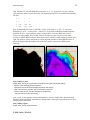
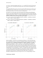
1
WIM Automation Module (WAM) USER'S MANUAL November, 2015 © Mati Kahru Contents 1 Purpose and Requirements ..................................................................................................... 3 2 WAM samples overview ........................................................................................................ 4 3 2.1 WAM programs with graphical interface ...................................................................... 4 2.2 Command-line WAM programs .................................................................................... 4 2.2.1 Anomalies, change detection and EOF ...................................................................... 4 2.2.2 Convert ...................................................................................................................... 5 2.2.3 Operations with bands ............................................................................................... 7 2.2.4 Compositing............................................................................................................... 7 2.2.5 Edge or Front Analysis .............................................................................................. 7 2.2.6 Image Operations ....................................................................................................... 8 2.2.7 Mapping ..................................................................................................................... 8 2.2.8 Primary Production and Export Flux ......................................................................... 9 2.2.9 Statistics ..................................................................................................................... 9 2.2.10 Screening Level-3 data according to quality flag ................................................ 10 2.2.11 Processing Level-1B MODIS data ...................................................................... 11 2.2.12 Processing Level-2 ocean color and SST data .................................................... 11 2.2.13 Merging Level-3 data .......................................................................................... 11 2.2.14 Inherent Optical Properties (IOP) ........................................................................ 12 2.2.15 Correlation between images and a point time series ........................................... 12 2.2.16 Simple utilities..................................................................................................... 12 2.2.17 Sample WAM programs for learning and testing................................................ 13 Examples of WAM programs ............................................................................................... 13 3.1 WAM programs with graphical interface .................................................................... 14 3.1.1 wam_series .............................................................................................................. 14 3.1.2 wam_match .............................................................................................................. 18 3.1.3 wam_statist .............................................................................................................. 23 3.2 Command-line WAM programs .................................................................................. 24 3.2.1 Anomalies, change detection and EOF .................................................................... 25 3.2.2 Convert to HDF/Compress HDF ............................................................................. 33 3.2.3 Operations with bands ............................................................................................. 40 3.2.4 Compositing............................................................................................................. 42 © Mati Kahru, WimSoft 3 WAM Specification 3.2.5 Edge or Front Analysis ............................................................................................ 44 3.2.6 Image Operations ..................................................................................................... 45 3.2.7 Mapping ................................................................................................................... 47 3.2.8 Primary Production and Export Flux ....................................................................... 52 3.2.9 Statistics ................................................................................................................... 59 3.2.10 Screening Level-3 data according to quality flag ................................................ 81 3.2.11 Processing Level-1B MODIS data ...................................................................... 83 3.2.12 Processing Level-2 ocean color and SST data .................................................... 86 3.2.13 Merging Level-3 data .......................................................................................... 95 3.2.14 Inherent Optical Properties (IOP)........................................................................ 96 3.2.15 Correlation between images and a point time series ........................................... 99 3.2.16 Simple utilities................................................................................................... 100 3.2.17 Sample WAM programs for learning and testing.............................................. 103 1 Purpose and Requirements WIM Automation Module ( = WAM) is a major addition to the tools available for WIM users. It allows automating repetitive or complex tasks by using WAM applications that call functions in the WIM library. For the user, WAM has three components. First, WAM programs with the graphical Windows interface make it easy for every WIM user to perform complex operations on a series of images. Second, users with just a little bit more computer knowledge can use command-line WAM programs and run complex applications on series of images. Third, users with interest in programming can use the WIM library to create their own WAM applications using any of the .NET languages, e.g. C#. WAM is based on the Microsoft .NET Framework. It is realized as a suite of dynamic link libraries that provide easy access to complex functions. Starting with Windows Vista the Microsoft .NET Framework is included in Windows but on older versions of Windows it was necessary to be installed separately. The default location for WIM and WAM programs (e.g. C:\Program Files\Wimsoft in English (US) settings) is added to the PATH system variable when installing WIM/WAM. Sometimes that fails and you need to manually add it. To do that define a new environmental variable, e.g. WIMSOFT, set it to the location of the location of your WIM/WAM installation and add it to the PATH environment variable. You can do it with Properties of My Computer (right-click on it), Advanced - Environment Variables. For example, in the Spanish versions of Windows the default WIMSOFT path is “C:\Archivos de programa\Wimsoft” instead of “C:\Program Files\Wimsoft”. You can write your own WAM programs. It is best to use the Visual Studio but you can also use the free command line compilers for C# included in the .NET Framework. You can start by compiling and modifying the sample WAM programs. Source codes of various WAM programs (all in the C# language) are included in the WAM_samples folder of the WIM/WAM DVD. WAM functionality is being extended and new functions are added to it. Therefore we recommend checking out the latest copy of WAM whenever you start a new project. © Mati Kahru, WimSoft 4 WAM Specification To compile your own programs you also need to add the location of the .NET Framework libraries to the path. For running the command-line C# compiler you also need to add its location to your PATH variable. For the version 2.0 of the .NET Framework it is "%windir%\Microsoft.NET\Framework\v2.0.50727". 2 WAM samples overview 2.1 WAM programs with graphical interface Program Name Purpose wam_series A GUI program designed to apply various operations to a series of matching images. It has options for input and output formats, cutting a sub-area, median filtering, overlays, converting, remapping, changing colors, etc. wam_match Finds matches between in situ measurements and a series of satellite images. Makes X-Y scatter plots of the satellite versus in situ data. Creates a CSV text file with match-up statistics of a DX x DY window image statistics corresponding to in situ measurements. wam_statist Calculates statistics of masked areas for a series of images. Using a list of images, an image with masked areas or list of stations, calculate statistics for the series of images. Output is a CSV file ready for importing into MS Excel. 2.2 Command-line WAM programs 2.2.1 Anomalies, change detection and EOF Program Name Purpose wam_annual_max Finds the annual maximum, minimum, time of the maximum, valid counts for each pixel in a series of matching HDF or netCDF datasets. wam_annual_timing Finds parameters of the annual cycle: first day and last day over or below a threshold for each pixel as well as counts of images satisfying these conditions in a series of matching HDF or netCDF datasets. wam_anomaly Calculates anomalies relative to the mean of overall, monthly 8-day or 5-day annual cycle. Reads all matching images, calculates and saves the means and counts, then calculates and saves the anomalies relative to the means. wam_change Calculates change between 2 images, shows the change, i.e. increase or decrease, as either ratio or difference. © Mati Kahru, WimSoft 5 WAM Specification wam_eof Runs EOF or Principal Component Analysis (PCA) on a series of images. See separate document Exercises_WAM_EOF.pdf for examples. Starting with WIM 9.x replaced with wam_pca. wam_pca Runs Principal Component Analysis (PCA) on a series of images. Similar to wam_eof but using a different numerical library. See separate document Exercises_WAM_EOF.pdf for examples. wam_kmcluster Performs k-means cluster analysis on a series of images using CenterSpace NMath Library. wam_shape For each pixel in a series of images, evaluates the normalized shape of the series versus a set of shapes, finds the closest shape using RMS differences. wam_count Counts the numbers of pixels larger or smaller than a threshold for a whole series of matching images, saves to a text file (CSV file). wam_trend Looks for trends in a set of images using the Sen slope or the Linear regression slope and the significance of the slope for each pixel. Replaces wam_max_trend. wam_variance Calculates pixel-wise mean, standard deviation and the number of valid pixels for a set of matching filenames. 2.2.2 Convert Program Name Purpose wam_compress_hdf Compresses datasets (SDS) within HDF files. This can drastically reduce file size without any noticeable difference for the user. wam_uncompress_hdf Uncompresses datasets (SDS) within HDF files. This increases file size and is used only because some applications cannot use compressed HDF files. wam_extract_SDS Extracts one or more datasets (SDS) from a HDF files with multiple datasets into HDF files of a single dataset. Similar to wam_disassemble. wam_assemble_hdf Assembles datasets (SDS) from a multiple HDF files into a single HDF file with multiple datasets. wam_disassemble Disassembles (breaks up) a HDF file with multiple datasets (SDS) into multiple HDF files with a single dataset each. wam_hdf2nc Reads all datasets (SDS) from matching HDF4 files and saves in corresponding netCDF files with extension .nc. wam_nc2hdf Reads all datasets (SDS) from matching netCDF files and saves in corresponding HDF4 files with extension .hdf. wam_convert_100xbyte Converts the float32 ice concentration HDF datasets to HDF as © Mati Kahru, WimSoft 6 WAM Specification scaled byte. wam_convert_amsre Converts datasets of AMSRE in binary format of the Remote Sensing Systems to HDF4. Can read the following datasets: SST, WSPD, VAPOR, CLOUD, RAIN. wam_convert_ascat Converts datasets of ASCAT in netCDF to HDF, transforms Latitude and Longitude from Int32 format to Float32. wam_convert_avisosla Converts datasets of AVISO netCDF files to HDF4.. wam_convert_ccmp Converts CCMP wind data in NetCDF format to HDF4. wam_convert_cm Converts CM-SAF surface incoming shortwave radiation data in netCDF format to HDF4, adding projection info. wam_convert_goes1112 Converts GOES 11-12 SST daily data from binary raster to HDF4 format, adds attributes for compositing and time series analysis. wam_convert_log Converts HDF datasets to HDF with log scaling of specified slope and intercept. wam_convert_dim Converts selected datasets in MERIS DIM files to HDF4 with longitude and latitude arrays for geo-location. See also wam_convert_n1. wam_convert_k2c Converts a selected dataset of temperature in Kelvin to Celsius in SST Pathfinder scaling , saves in HDF4 format. wam_convert_mld Converts the Mixed Layer Depth datasets in Float32 format to HDF4 in Int16 format, optionally masks land. wam_convert_n1 Converts the ENVISAT (including MERIS) N1 files to HDF4 with longitude and latitude arrays for geo-location. See also wam_convert_dim. wam_convert_ncsst Converts the global 6-km SST data from GHRSST netCDF files into HDF4 files. wam_convert_ngsst Converts the New Generation SST (NGSST) binary datasets to HDF4 while adding attributes. wam_convert_oisst Converts the OI (Optimum Interpolation) SST (OISST) binary datasets to HDF4 while adding attributes. wam_convert_percent Converts percent (range 0.0-100.0) to fraction in a scaled byte (e.g. 0.0-1.0). wam_convert_ssmi Converts raster SSMI binary files of ice concentration to HDF4 with added attributes, scaling and projection wam_convert_to_lin Converts float32 HDF4 datasets to byte with linear scaling. wam_convert_to_power Converts HDF4 datasets to the power of, e.g. 2 or 3. wam_gradient Calculates horizontal or vertical spatial gradients. wam_mirror Mirrors over vertical, horizontal or both axes; optionally sets projection. © Mati Kahru, WimSoft 7 WAM Specification wam_replace_pixel_values Replaces all unscaled pixel values with a new unscaled pixel value in all matching HDF4 files. wam_replace_values Replaces a range of scaled pixel values with a new scaled pixel value in all matching HDF4 files. wam_lin_transform Applies a linear transform Y = A * X + B to all valid pixel values of a series of matching HDF image files. 2.2.3 Operations with bands Program Name Purpose wam_band_ratio Calculates a series of new Chl-a or CDOM images using a set of Rrs datasets with a band ratio algorithm, e.g. OC4 or SPGANT. wam_ratio_2sets Calculates a series of ratio images using 2 sets of images. wam_blend_spgant Blends Southern Ocean product with standard (global) products according to Kahru & Mitchell (2010). 2.2.4 Compositing Program Name Purpose wam_composite Create an average composite and a count image of a series of HDF images. Reads HDF files either from a list file or from a matching pattern, saves as HDF files. Checks for start and end times to save composite start and end time attributes. wam_composite_pairs Reads a list with 2-columns of filenames, composites each pair wam_composite_quikscat Reads all Level-3 QuikSCAT files in the folder, calculates the mean composite of ascending and descending orbits, saves as HDF files. Obsolete, needs to be updated. wam_rotate Reads pairs of datasets corresponding to respectively eastward and northward wind components and calculates the components in any direction. 2.2.5 Edge or Front Analysis Program Name Purpose wam_edge Edge (front) detection on a series of images. Runs SIED edge detection algorithm, finds the frequency of edges on a series of SST images. wam_edge_accumulate Accumulates statistics of edge images. © Mati Kahru, WimSoft 8 WAM Specification 2.2.6 Image Operations Program Name Purpose wam_contours Automates creating isoline contours of Examine-Contour Lines in WIM wam_mozaic_land_ocean Makes a mosaic from two RGB images based on the pixel value of a mask image. wam_overlay Makes a series of overlaid images using a single overlay or respective overlay files. wam_reduce Reduces a series of HDF images. Reads all matching HDF files in a folder, reduces the size by a predefined times using a selected reduction type, saves each as HDF. wam_reduce_valid Reduces a dataset from a series of HDF or netCDF files while using only valid pixels; can also extract a certain dataset from a file with multiple datasets. wam_reduce_fixed Reduces a series of HDF images to a fixed size (192 x 94) while using the valid range. 2.2.7 Mapping Program Name Purpose wam_remap Remap a series of images, possibly with external georeferencing to a target projection. Read all matching HDF files, pick SDS, guess the respective geo-referencing file, map to the target projection, save as HDF. wam_remap2 Remap a series of images, possibly with external georeferencing to a target projection. Options for selecting SDS, median filtering, fill-holes filling and selected LUT. wam_remap_all Remap all datasets of a series HDF4 or netCDF files. wam_remap_lla Remap a series of images with external latitude/longitude array (LLA) to a target projection. wam_remap_and_overlay Remap and overlay a series of images. The target projection image is also used as an overlay. wam_remap_to_kmz Remaps a series of images to a target projection that must be Linear, overlay the target image and annotate. Output is saved as KMZ for visualization in Google Earth. wam_remap_regions Remaps a series of images to multiple target projections. wam_xy2ll Calculates latitude and longitude from x, y. wam_ll2xy Calculates x, y from latitude and longitude. © Mati Kahru, WimSoft 9 WAM Specification 2.2.8 Primary Production and Export Flux Program Name Purpose wam_npp Calculates NPP images using the best matching set of images and various algorithms. wam_npp_lee Calculates net primary production (NPP) images using the absorption based algorithm of Lee et al (2010) and output from the QAA model (wam_qaa_l2 or wam_qaa_l3). wam_npp_list Calculates net primary production (NPP) images using a list of Chl, PAR and SST images and the Behrenfeld-Falkowski (1997) VGPM model with various options. wam_npp_point Calculates NPP statistics for a list of “stations” (longitude, latitude, date, time) and series of images using various algorithms. wam_ef Creates datasets of export flux of carbon using the various models and input datasets like NPP, SST and Chl-a. 2.2.9 Statistics Program Name Purpose wam_fill Fills invalid pixels with the mean of the neighboring valid pixels with options for masking land and ice wam_fill_intime Fills invalid pixels with linear interpolation from previous and next image or only the next image wam_fill_with Fills invalid pixels with the corresponding values from a another matching (in time) dataset wam_histogram Calculates histograms of pixel values for a set of 1 byte-perpixel images in HDF files, saves the histogram in a CSV file wam_integrate Integrate a series of images to calculate, e.g., total global primary production or integrated values for specific areas wam_map_match Reads a match-up file generated with wam_match_l2 or wam_match_nearest and the corresponding image files and shows the matchup point on the corresponding image wam_match_l2 Finds match-ups of selected variables in ocean color Level-2 files to a list of stations. Saves statistics of square pixel areas centered at a station wam_match_multiband For a list of stations, finds a set of match-ups from different data files (e.g. Rrs bands) from nearest images in time with valid data wam_match_nearest For a list of stations finds satellite match-ups of Level-3 data, i.e. the nearest image in time with sufficient valid data and calculates statistics for a square pixel area centered at the station © Mati Kahru, WimSoft 10 WAM Specification wam_pixelwise_match Finds pixelwise matches between 2 sets of images, optionally plots the scatter plot wam_pixelwise_match_add Adds pixelwise matches between 2 sets of images to a CSV file produced in wam_pixelwise_match, e.g. of other bands wam_read_match Reads match-up file generated with wam_match_l2 or wam_match_nearest, filters subsets, makes plots and calculates statistics and can also calculate new variables wam_pixel_extract Extracts pixel (specified by its X and Y coordinate) value from a series of images in HDF4 or netCSD files, saves in a CSV text file. wam_statist_grid Calculate statistics for latitude/longitude grid for a series of images. Reads a series of images; calculates statistics for a lat/lon grid, saves statistics. wam_statist_mask Command line version of wam_statist. Calculate statistics for a single area for a series of images. wam_statist_sta Reads a list of stations (specified by longitude, latitude, name) and all matching images; calculates statistics for 3x3 pixel areas centered at the station, saves statistics and all 9 pixel values in a CSV text file. wam_make_mask Makes a single rectangular mask image, saves as HDF and PNG. wam_label_mask Labels the mask image used in wam_statist: writes the sequence number into the middle of each mask, saves as HDF and PNG. sortmasks sortstas sortgrid Sort the statistics of masked areas by area instead of by image. Sorts the statistics by mask number of a text file created by wam_statist. The output files are sorted and ready for plotting with MS Excel. 2.2.10 Screening Level-3 data according to quality flag Program Name Purpose wam_screen_goes1112 Using cloud probability as a quality flag image, screens GOES 11-12 SST data, i.e. keeps only the high-quality pixels while replacing others with zeros. wam_screen_mask Screens standard files; sorts into folders depending on valid pixels found in a masked area of interest. wam_screen_pf Screens AVHRR Pathfinder version 5 files, keeps only the best quality pixels. Uses both SST and quality images, masks low quality pixels, converts to Byte with SST-Pathfinder scaling. wam_screen_sst_ocpg Using a quality flag image, screens, i.e. keeps only the highquality pixels while replacing others with zeros. Screens Level3 MODIS Aqua (and Terra) SST data produced by the Ocean © Mati Kahru, WimSoft 11 WAM Specification Color Processing Group, converts to Byte with the SSTPathfinder scaling. 2.2.11 Processing Level-1B MODIS data Program Name Purpose wam_rgb_modis Creates co-registered true-color RGB composites from MODIS Level-1B data at 1 km, 500 m or 250 m resolution, does accurate band co-registration, optionally maps to a target projection. See separate document Exercises_modis_250m.pdf for details. zoom_modis_lat_lon Interpolates 1-km MODIS latitude-longitude array to 250-m resolution. Reads all matching MOD03 or MYD03 files and interpolates the latitude and longitude arrays to 250 m. See Exercises_modis_250m.pdf for details. wam_turbidity Calculates turbidity index from MODIS bands1 and 2, maps to a target projection. Reads a crefl-produced HDF file produced with bands 1 and 2, MOD03 geo-referencing file. See Exercises_modis_250m.pdf. wam_turbidity_aster Calculates turbidity index from ASTER bands1 and 2, maps to a target projection. See Exercises_ASTER.pdf. 2.2.12 Processing Level-2 ocean color and SST data Program Name Purpose wam_l2_map wam_composite_2sensors wam_composie_sensors wam_mosaic_2sets wam_composite_2x wam_composite_intime wam_composite_month wam_composite_year wam_composite_last wam_composite_list wam_composite_running wam_rrs_l2 A suite of programs to map and composite NASA Level-2 ocean color and SST datasets. Starting with the Level-2 data and flags to create daily mapped composites. Daily composites are then used to create higher level composites, e.g. multisensor, 5-day, 15-day, monthly, yearly, last N day, running N day or composites specified by a time range or a list of files. wam_rrs_l2 applies various algorithms to level-2 Rrs data. 2.2.13 Merging Level-3 data Program Name Purpose wam_merge_l3 Merge different Level-3 products (even with different resolution). For example, by merging all-weather but lowresolution microwave SST with high-resolution but clearweather infrared SST you get merged SST product. © Mati Kahru, WimSoft 12 WAM Specification 2.2.14 Inherent Optical Properties (IOP) Program Name Purpose wam_qaa_l2 Calculates Inherent Optical Properties (IOPs) such as spectral absorption and backscattering coefficients (e.g. a490, aph440, adg440, bbp490) from Level-2 remote sensing reflectance (Rrs) data using the Lee et al QAA algorithm. wam_qaa_l3 Similar to wam_qaa_l2 but using Level-3 remote sensing reflectance (Rrs) data. wam_qaa_match Calculates Inherent Optical Properties (IOPs) such as spectral absorption and backscattering coefficients (e.g. a490, aph440, adg440, bbp490) from a CSV file with remote sensing reflectance (Rrs) data using the Lee et al QAA algorithm. 2.2.15 Correlation between images and a point time series Program Name Purpose wam_correlation Calculates a correlation image (with each pixel representing the correlation coefficient) between a series of images and a 1dimensional time series, e.g. an ENSO index. wam_correlation_series Calculates a correlation image (with each pixel representing the correlation coefficient) between two series of images. wam_corrmatrix Calculates a correlation matrix between two sets of time series. 2.2.16 Simple utilities Program Name Purpose MakeCircles Draws circles centered at a given list of points with a give radius. This helps to make masks for calculating statistics in circular areas around a set of points with wam_statist. rcrit Calculates confidence limits for correlation coefficient with a given number of pairs. wam_add_attribute Adds a global string attribute to a set of matching HDF files. wam_add_name Renames the SDS in the file with the name of the file. Many standard products use the same SDS name, e.g. l3m_data. In many cases it is useful to have the images (datasets) named with a name that clearly identifies the image. wam_cut Cuts a specified rectangle image from a series of matching images in HDF4 or netCDF files. See also test_cut_hdf. wam_minmax Shows the valid range for a set of matching HDF files. wam_setMinMax Sets the valid range for a set of matching HDF files. wam_proj_lin Adds coefficients of a specified Linear projection to a set of © Mati Kahru, WimSoft 13 WAM Specification HDF files. wam_show_time 2.2.17 Shows the start year, start day, end year and end day of a set of matching HDF files. Sample WAM programs for learning and testing Program Name Purpose test_cut_hdf Shows how to create a series of images of a selected sub-area, and save as JPEGs, GIFs or HDFs. This example shows how to read all matching HDF files in a folder, cut out a predefined sub-area, stretch the color scale, save each in different formats. test_bandratio Shows how to calculate a new image using a band ratio algorithm. Reads all matching pairs of image files in HDF (e.g. of 443 and 520 nm bands) in a folder, applies a band ratio algorithm, saves the calculated image as a float HDF, converts to a BYTE image using CHL scaling, stretches colors, saves as a JPEG. wam_filter Apply a filter, e.g. Median filter, to a series of images, save the results. Reads all matching HDF files in a folder, cuts out a predefined sub-area, applies the Median filter, and saves each as a JPEG. wam_attribute Print the value of an HDF attribute from a series of HDF files. Reads all matching HDF files in a folder, extracts the value of an integer attribute (e.g. “Start Day”), and prints the file name and the attribute value. test_statist Calculate statistics of a rectangular area. Reads a specified image as HDF, calculates statistics for a specified rectangular area, prints to the screen and saves in a text file. wam_rgb Simple example for creating series of RGB composite images. Reads all matching image files from a folder, calculates RGB images from selected bands. wam_to_hdf Converts all matching plain raster images in a directory to HDF while adding attributes. Using filenames as clues for time it tries to add attributes like “Start Year”, “Start Day” that are needed for time series analysis. 3 Examples of WAM programs The following are examples of WAM programs. Some of the programs are quite complex and powerful while some are simple examples. The source codes of all are included. You can compile the example programs with the C# compiler or run the precompiled executables. To build a simple command-line program, cd to the directory of your source code and type “c“ followed by the program’s name without the extension. For example, to build a C# program test.cs, cd to your WAM directory and type © Mati Kahru, WimSoft WAM Specification 14 c test On success the batch file (c.bat) makes an executable test.exe in your WIMSOFT directory. Remember that the executable must be in the same folder as your WIM executables and DLLs. You can now run the program by typing test Remember that your WAM executables have to be in the same folder as the WIM executables and DLLs. 3.1 WAM programs with graphical interface 3.1.1 wam_series Wam_series is a Windows forms based application using WAM for doing multiple operations on a series of images. A common scenario for WIM users is that there is a set of images that need the same kind of kind of operations. You can perform the operations manually with WIM but doing it on many images becomes time consuming and error prone. For example, you may have a large batch of global images but you want to cut out a small subset of your area of interest, may-be map it to another projection, overlay coastlines and/or station locations, stretch the color scale, annotate with year and date, and save in a number of different formats (GIF, JPEG, PNG, HDF, Lat/Lon/Value). You can do all this and a set of other operations with a few mouse-clicks using wam_series. Another important benefit of using wam_series (instead of doing it interactively with WIM) is that you can save a record (log) of your operations and can use the same operations and parameter values another time on a different set of images. As an odd remnant of an early version, wam_series can also calculate statistics of a selected rectangle for a series of images although it is recommended to use wam_statist for this kind of work. Wam_series has a number of input fields for specifying the sources, outputs and operations. All selected options are stored in the registry just before processing starts, so even if you close wam_series or turn off the PC, the next run of wam_series will start the options selected during your last run. However, this method only saves the last set of options. When you want to switch between multiple projects you can save the settings of each projects in a separate log file. All the parameter values are saved in a log file and can be read back from the log file when needed again. The following are the available input parameters: “From dir”is the input directory where the input files area. You can just navigate to the folder where your files are and copy and paste the Address bar. “File pattern” is how you specify the files in the input directory. For example, you may first want to process only files from 1999 and give “S1999*.*” as the pattern and later give “S2000*.*” to process 2000 files. Please be careful with matching too many files: you may match files that are not suitable and produce an error. “To dir” is the folder name where your output files will be written, e.g. “C:\WAMout” could be used for output files from wam_series. “Save Log” and “Get Log” are buttons for saving/reading the all parameters to/from a log file. When you click on “Get Log” a file picker dialog starts. When you click on “Save Log” you need to have typed the full path of the log file in the text box immediately to the right of the button. When you just start experimenting with wam_series, you can ignore the log options. The © Mati Kahru, WimSoft WAM Specification 15 logs are for simple text files for saving all the parameters of a project so that you can restore them later. “Input type” lets you specify the input type of files (HDF, netCDF, CoastWatch, Img (Byte), L1B). With HDF and netCDF files you can also specify the sequence number of a particular dataset (starting from 0). In HDF4 and netCDF files containing a single image this should be “0”. “Save as” lets you specify the output file type as GIF, JPEG, PNG, HDF, HDF with LLA and/or Lat/Lon/Value. If you specify statistics as processing option then no output files other than the statistics result is created. The following processing options are available: Median filter with the window size (typically 3 x 3 or 5 x 5 pixels) lets you smooth the output image with a median filter of a specified size. Fill Holes with the window size (typically 1 x 1 or 3 x 3 pixels) lets you fill zero-valued pixels (e.g. missing data due to clouds) with the mean value of the non-zero neighboring pixels. As a side-effect it also fills areas that are not supposed to have valid data, e.g. land if you are working with ocean data. In that case you can mask the unwanted modifications with a custom overlay (see the Overlay option below). Remember that you cannot overlay 0-valued pixels as they will be transparent, i.e. the image will retain its current value and not attain the overlay value. A remedy for that case is to use a small non-zero pixel value (e.g. 1) in the overlay and use Color Stretch with the start value above the non-zero pixel value. Mirror? (Upside down?) is a seldom used option. It may be needed for Level-1 or Level-2 data (i.e. unmapped) from ascending orbits (e.g. Aqua) where the image may appear upside down. WIM will normally try to mirror the image automatically. Rotate 90 deg option will rotate the output image by 90 degrees. Currently the geo-location parameters are not converted. If you save just the bitmap (e.g. JPEG or PNG) then it does not matter, however, if you save as HDF and later try to read that HDF file then the geo-location will be wrong. “Coastlines” with Overlay Pixel Value lets you specify the WIM coastlines file to be used (for example, C:\Wimdev\Maps\coast_inter.b) and the pixel value of the coastline. Typically, you may want to use 255 (white) for the coastlines to be visible on black background or 1 (purple or black) on white background. Please note that the overlay is created for the first image file and is assumed the same for the remaining images. If you are remapping images to a target projection then they will all have the same size and projection. In that case it is more versatile to create an overlay file – including not just coastlines but possibly lat-lon grid, station locations, land painted to a different color, color bars, etc – and then use the Overlay option (see next). “Overlay” lets you specify an overlay file that you have to generate manually with WIM before running wam_series. For example, you may want to put a specific latitude, longitude grid, manually edited color scale, locations of certain stations of labels - practically anything on top of all the images. Bathymetry contours may be used in the overlay image. Remember that the overlay needs to be of the same size as the output files and the background (transparent on the overlay image) needs to have pixel value of 0. Remember that if the overlay pixel value is 0, it will be transparent, i.e. the image will retain its current value and not attain the overlay value. “Load Palette” lets you specify a specific palette file (usually *.lut) that you load for each image. That will change the color palette of the image. For example, when working with anomalies you may want to use a specific palette (e.g. anomaly.lut or anomaly7.lut). © Mati Kahru, WimSoft WAM Specification 16 “Annotate” with selectable X and Y values lets you specify where an annotation consisting of the year and start day of the image will be put. X means the distance in pixels from the left and Y means the distance in pixels from the top. If you use “-1” for any of these, the default values corresponding to the top right corner will be used. The program tries to guess the start year and Julian day from the image name. This works for most SeaWiFS, MODIS Level-3 images, Pathfinder SST images, etc. If it does not work for your images, please let Wimsoft know and we will try to make it work. “Cut subimage?” with latitude values for the North (top box), South (bottom box), longitude values for the East (right box) and West (left box) lets you cut out a rectangular area as the area of interest for either saving or statistics. Remember to use negative longitude for West longitudes and negative latitude for south latitudes. All values are in decimal degrees, e.g. latitude of 0.5 means 0 degrees and 30.0 minutes north. Please note that if you are remapping images to a target projection then you don’t need to use “Cut subimage?”. If you cut a wrong area, your remapped image will be empty. If the image has no projection then, of course, you cannot locate certain latitudes and longitudes. For images with no projection the “longitude” and “latitude” values will mean just the x and y of the image coordinates. “Statistics” with “Valid Min, Max” selects to calculate statistics for either the whole image or a subarea specified by the “Cut subimage” values. The resulting output file of statistics for the whole series of images is saved in a text file statistics.txt in the current folder. The Min and Max values for the valid data range need to be specified as invalid values should be excluded from the statistics calculations. For example, in case of typical chlorophyll-a values the Min and Max can be 0.015 and 64.0, respectively. Please note that Statistics excludes most other operations, i.e. if you are calculating statistics then you are not creating images and vice versa. “Min, Max Temperature for CoastWatch” is only used if the input files are of the CoastWatch type and lets you specify the min and max temperature values. From August, 2006 on this option is no longer available from the GUI. It is still possible to change these values by editing the log file. “Convert to byte?” lets you convert multi-byte (e.g. Int16 and Float) images to simple scaled byte images that are easier to manipulate and visualize. The selectable scalings are “Chlor_a, Logarithmic”, “SST-Pathfinder”, “Pixel_Value”, “Linear”, “Logarithmic”. With the last 2 you can also set the “Slope” and “Intercept” fields. “Color stretch” lets you specify the “Start” and “End” values corresponding to the View-Set Colors (color definition) type of color stretch operation in WIM. “Remap to” lets you remap the image to a selected image in a specific projection (and size). The default mapping option is “Inverse Mapping” that usually produces best looking images but may be very slow for large LLA images. The Forward Mapping is usually the fastest but may produce gappy images. The Forward with Fill Gaps starts with the Forward Mapping and then uses Inverse Mapping for the gaps. The output window shows short log from the program. “Start” and “Quit” buttons are for…, you guessed it! When processing large images the program may need a lot of RAM and may take a long time to process a large number of images. It is recommended to start with a small subset of images by selecting a file name pattern that includes only one or two images. You may want to process your series of images in more than one batch, e.g. separating the batches by year, date, etc. © Mati Kahru, WimSoft WAM Specification 17 The recommended coastlines file is coast_inter.b (see WIM.pdf = WIM User’s Manual for details on GSHHS coastline files). When using overlays, all the input files should be of the same size and projection (location). The first overlay is generated dynamically from a selected global coastlines file. This overlay is generated only once, i.e. for the first image. It is then assumed that all the following image files have the same size and projection after processing and before the overlay is being used. It would be possible to remove this restriction and create a new coastlines overlay for each image file but that would make the program slower. Please note the pixel value of the generated overlay. For SeaWiFS Level-3 images you may want to use a pixel value of 1 whereas for Pathfinder SST a good value would be 255. This is because land pixels on SeaWiFS images are typically white and using pixel value of 255 would typically make a white overlay on white background. In contrast, Pathfinder SST images have land with black pixels (value = 0) and it is appropriate to use white (typically, pixel value 255) as the overlay pixel value. The overlay is assumed to be pre-generated with WIM and saved in HDF format. Using a pre-generated overlay can be used, for example, to put bathymetry contours, station locations or other predefined features on the series of images. Bathymetry contours have to be generated in WIM in a 2-step process using Geo-Bathy Image first and then applying Examine-Contour Lines. For HDF files you can select the (0-based) sequence number of the SDS (image) that you want to use from each file. As you know, each HDF file can have many images in the form of SDS (Scientific Datasets). The default is to read the first (0-th) SDS but you can select another SDS. For example, if you want to use “chlor_a” from set of SeaWiFS Level-2 HDF files with the following SDS-s: longitude, latitude, chlor_a, l2_flags, eps_78, K_490, nLw_412,… you need to select “2” for the SDS number. Please note that the sequence of SDS-s in a file is created by WIM and does NOT include the SDS-s that are eliminated by “Settings”-“Special”-“Minimal width of image to be read”. For example, let’s say that you have set the Minimal width to 200 and the longitude and latitude arrays in a SeaWiFS Level-2 file are only 161 pixels wide. In that case the longitude and latitude are not counted in the sequence of images read by WIM (or WAM). Therefore, the previous sequence of images would become: chlor_a, l2_flags… and instead of “2” you need to select SDS number 0. The Convert to BYTE function is needed only for multi-byte images (e.g. for int16 and float32 images). The options that are not applicable using the current selections are gray and not available for modification. A screenshot of the default wam_series screen is shown below. © Mati Kahru, WimSoft WAM Specification 18 3.1.2 wam_match Introduction. The need to understand the relationships between satellite data and ground measurements is fundamental in any application of satellite measurements. The problem is that satellites never measure exactly the same variables as ground measurements. Of course, ground measurements can also use different methods that need to be inter-calibrated and inter-validated. For example, when measuring ocean chlorophyll the ground measurements include variants of HPLC, fluorometry and spectrophotometry. Satellite measurement of chlorophyll is based on radiance spectrum measured at the top of the atmosphere. It is a very complex process to derive, first, the water-leaving radiance and, second, the chlorophyll concentration. There is no one-toone relationship between the remote and ground methods. Another source of discrepancy is the huge difference in the measurement footprint. The sampling area of a typical ocean color sensor © Mati Kahru, WimSoft 19 WAM Specification is 1 km x 1 km whereas ground sampling is usually done with a water bottle with scales of the order of a decimeter (10 cm). A different scenario for doing satellite-ground match-ups is to use satellite data but relate these to totally different kind of ground measurement, for example to compare satellite-detected sea-surface temperature or chlorophyll concentration with the distribution of whales or turtles. The idea of finding matches between satellite and in situ data seems simple but in practice the task may easily get overwhelming. Let’s say you have a set of measurements that you want to compare with satellite images. You can just move the mouse pointer and by right-clicking in WIM see the geophysical values at a certain location of longitude and latitude. This can be done if you have only a few points and a single image. However, usually we have a whole time series of images and a set of points. The number of all possible pairs of comparisons gets too big too easy. With only 10 points and 10 images we may have to find 10 x 10 = 100 corresponding matching points. We may also want to choose selectively only those images and those points that have the time difference between them below a certain time limit. This means that even with 10 points and 10 images we have to do 100 comparisons of the time difference between a point and an image. We can easily imagine what will happen if we have hundreds of points and hundreds of images: the task just gets overwhelming to be done “manually”, i.e. we need a special software program to do that. Design. Wam_match is a complex utility that is based on WAM functions but also uses routines from other libraries (e.g. graphics and data grid). The purpose of wam_match is to generate match-up datasets between satellite and in situ data. The idea behind this utility is that you have a set of in situ data (a set of points) collected from a set of locations in space and time, i.e. specified by longitude, latitude and time. You then use a list of satellite images and try to find matching points between the points and the images by applying several constraints, e.g. that the time interval between the point value and the satellite pass is no larger than dT hours and the ground point is inside the satellite image and has valid values (i.e. is not cloud-covered or otherwise invalid). The satellite images can be from a single pass or from a composited image. A composited image is a certain average over the compositing period that is typically 8 days, a month or a year. When making time comparisons between point and satellite data we therefore assume that the point data have a fixed sampling time (Tpoint) but the satellite data have a range from start (Tstart) to end (Tend). We set a maximum time difference dTmax and assume that we have a match-up in time between a point and a satellite image if Tpoint >= (Tstart – dTmax) and dPoint <= (Tend + dTmax). The following figure illustrates this condition. Point time Tpoint can be between Tstart and Tend but does not have to. It needs to be between Tstart – dTmax and Tend + dTmax. Typical maximum time difference dTmax is 3 or 4 hours when using a single satellite pass but can be relaxed to cover more than 1 day. When using composited images of, say, 8 days, it should be feasible to use dTmax of 24 hours or more. Tend Tstart Tstart- dTmax © Mati Kahru, WimSoft Tpoint Tend+ dTmax WAM Specification 20 The restriction on space is typically that the point sample is within a certain rectangular window centered at the nearest matching pixel. Typical windows are 3 x 3 or 5 x 5 pixels in size. It is possible to use the value from the single nearest satellite pixel but more often the mean or the median of the valid pixels within the 3 x 3 window are used. This is because the nearest pixel may not be the best match-up with a point sample considering advection by ocean currents during the time interval between the point sample and satellite image. An important restriction is the validity of the satellite data. Invalid or missing data within an image is caused, e.g. by clouds, and is usually flagged or masked with invalid pixel values. There are two ways of separating valid values from invalid values: using a valid range or a separate image of flags. Valid range with Min and Max is the easiest way of defining valid pixels. The problem is that the valid range may not obvious and may change for different scalings. Also, when doing match-ups with multiple images in the same file (e.g. chlor_a, nLw412, nLw443, nLw490,…) the valid range may be different for the individual images. Also, in some cases we may need to have more details in the classification of pixels based on their quality. Using flags allows a more detailed characterization of the “quality” of match-ups. For each pixel a set of flags is generated. Each flag indicates a certain condition is confirmed. For example, SeaWiFS Level-2 images have 32 flags each of which can be on or off. These flags include likes of high satellite zenith angle, stray light, high solar zenith angle, navigation error, moderate sun glint, etc. You can pick any combination of these to exclude points. For example, high satellite zenith angle indicates low quality matchup and these points should be excluded from high-quality pixels. Most of the flags, excluding OCEAN flag indicate some problem with the pixel. Using flags to eliminate pixels from match-ups is a versatile method but can only be used if such a flag image is available. Wam_match is currently set to use SeaWiFS Level-2 flags and are not suitable for MODIS and other sensors. This may be changed in the next releases of wam_match. A screenshot of the current wam_match is shown below. The screen resolution for running wam_match should be at least 1024 x 768 pixels. Wam_match uses registry to store last parameter values. The following input fields are used. “Use flags” checkbox indicates if flags are to be used. If selected, a list of 32 flags (currently of the SeaWiFS Level-2 flags) can be selected. The OCEAN should be left unchecked if ocean pixels are sought. You may start with now flags selected and one by one add flags to eliminate pixels. You can start with only a few or no flags checked in order to get many match-ups, and then one-by-one set the flags to see which flags eliminate which match-up points. The eliminated match-ups will be moved to a special “eliminated” set of match-ups and can be examined after saving to a CSV file. “List of Images” specifies a text file that has a list of image files to be used in the matchup with each image file (full path name, e.g. D:\sat\seawifs\L2\ace0103\V4\S2001105040220.L2_HRBN.sub1.hdf) on a separate line (see a sample list). The image list is easily generated by a command like this: dir/b /s S*.hdf > list.txt. The option /s adds the full path to the files (e.g. C:\sat\SeaWiFS\L2\cal0004\). Check out the sample list file list_mapped.txt. Please note that with image files (e.g. MODIS Level-2, GLI Level-2) having the latitudelongitude arrays (LLA) in a separate file, the list file format is slightly different. After the © Mati Kahru, WimSoft 21 WAM Specification first image name, the name of the file with the LLA is listed after a comma. No full path is given for the LLA file, it is assumed to be in the same folder as the primary file. Lon “List of Point data” specifies is a text file that has a list of ground points (stations) to be used in the matchup. The point list is in the WIM point file format and has tab or comma separated columns of longitude, latitude, date and time followed by station and whatever measurements you have. See included sample point files. The point list is best generated in Excel worksheet and saved as tab or comma separated text file (CSV file). In WIM point files have traditionally had *.pnt extension but you can also use the *.csv extension that is more compatible with other programs. The first line in a point file is a header and is not used for data. The format of a point file is the following: Lat Date Time Cruise Station Pt_Value -117.303 32.958 4/7/2000 22:07 CAL0004 93.26.7 2.11 -117.401 32.930 4/7/2000 23:07 CAL0004 93.28 2.11 Any number of lines can follow the header with each point as a separate line. Points can be excluded without deleting the line by preceding the line with the # character. The minimum set of columns is Longitude, Latitude, Date. If Time is missing then it is assumed to be 12:00. Check out the sample point file match.csv. The date has to be in the US format of MM/DD/YYYY or the European format (DD/MM/YYYY). The European format is assumed only if a decimal comma is detected in the Longitude value. “Time lag, hr” specifies the maximum time lag in hours from the start or end time of the image in hours (see a figure above). Please note that in case of composites the interval between the start and end time can be a month (in case of a monthly composite) and the time lag is counted from the start and end. “Windows, DX x DY” specifies the size of the window in pixels where the matchup statistics is calculated. 3 x 3 pixels is typically used but may be increased to 5 x 5 or even bigger. “Min Valid Pixels” specifies the minimum number of valid pixels in the window to accept a matchup. For example, in case of 3 x 3 window we may request that at least 5 pixels (out of 9) be valid in order to accept a matchup. “Save results in” specifies a file where the results will be save in CSV (Comma Separated) format. “Bands” with individual checkboxes for up to 16 bands (starting from band 0). HDF files (e.g. SeaWiFS Level-2 files) may have many images in the same file and you may select more than one bands for match-ups. If you selected to use flags (“Use flags”) then the flags image will be used anyway (if found). The standard mapped images (SMI) in Level3 have typically a single image and the 0th band should therefore be used. For example, if you want to use “chlor_a” from set of SeaWiFS Level-2 HDF files with the following scientific datasets (SDS): longitude, latitude, chlor_a, l2_flags, eps_78, K_490, nLw_412,… you need to select only band “2”. Please note that the sequence of SDS-s in a file is created by WIM and does NOT include those SDS-s that are eliminated by Settings-Special-Minimal width of image to be read. You can check the bands with WIM before searching for match-ups. © Mati Kahru, WimSoft WAM Specification 22 “Valid range, Max, Min” specifies the minimum and maximum value to be considered valid. Only valid pixels are used in the statistics calculations. It is only used when “Use flags” is not selected. After the user clicks on the “Start” button the search for match-ups begins. A log of output is printed into the text box while the found match-ups (if any!) are put into a data-grid and into a graph. In this screenshot example given below 34 matches were found. There are now several ways of tracing the origins of each matchup. You can select variables to be plotted from the point dataset (X-axis) versus variables from the satellite data (Y-axis) as well as the point’s “Label” variable using respective up-down controls. The point’s “Label” is shown in the “Point Label” text box. A “label” is actually any field in the point table (e.g. longitude, latitude, date, time, etc.) and can be selected in the “Select Point Label” domain up-down control. When moving the mouse cursor to a particular point you can see the point label in the “Point label” text box. Also, in the data-grid the corresponding row is selected. Vice versa, when a row is selected in the datagrid by selecting it with a mouse click, the corresponding point in the plot will be surrounded by a blue diamond frame. The value is used to represent missing values in both the point and satellite data can be chosen. Typical values are 0 or -9. All matching points can be saved in a CSV (comma separated) file than can be loaded into Excel for further analysis. By double-clicking on a point in the graph that point will be eliminated from the set of match-ups shown in the graph and in the data-grid, and placed into a set of “eliminated” matches. Both the retained and eliminated matches will be saved to a CSV (comma separated) file when “Save as CSV” button is clicked. Respectively, “Save as XML” saves the matches in an XML files but this function is not properly implemented yet. “Save as PNG” and “Save as EMF” buttons save the graph in the PNG (portable network graphics) and EMF (enhanced windows metafile) formats, respectively. For running wam_match you basically need a set of satellite images, a list of these image files in a list file and a point file with a list of ground samples. Please note the format of these files, especially of the point file and use exactly the same format of representing dates and times. Check out the sample list file list_mapped_C.txt and sample point file match.csv. These files should be in your WimSoft folder (e.g. C:\Program Files\WimSoft). The results will be probably wrong if you use a different format. First try to replicate the results of the figure below with the sample files. You need to copy the sample images from the WIM/WAM CD to your hard disk. The sample list file expects them to be in C:\Program Files\WimSoft\Images\SeaWiFS\baja_2000_april. You can get this if you just manually copy the Images folder from the CD to your WimSoft folder. The Images folder has a lot more files than are needed for this example but you may delete them later if not needed. Fill out all the control boxes exactly as in the figure below, then click Start. You should get exactly the same results, i.e. 34 matches. As you see some of the matches look like outliers. If you move your mouse pointer to the point in the scatter plot, the corresponding row in the data grid will highlight. If you double-click on the outlier (or any other match-up point for that matter), the point will be removed from the plot and from the match-up set to the eliminated set of match-up points and the figure will be rescaled. Both sets (match-up points and eliminated match-up points) will be saved to a comma separated (CSV) files if you click Save as CSV. The graphs can be saved as PNG or EMF. Note that in this example only one image (SDS) was present in the image files, also that no flags were used. © Mati Kahru, WimSoft WAM Specification 23 Now you are ready to try to match up your data with satellite images. Just please follow the formats. Related command line utilities, such as wam_match_nearest, wam_match_multiband and wam_match_l2, do not need a list file of images. Instead, they find the nearest image in time with sufficient number of valid pixels corresponding to a station (defined by longitude, latitude, date and time). 3.1.3 wam_statist wam_statist is a Windows Forms program that combines the functionality of wam_statist_sta and wam_integ_mask with a GUI and should be easier to use. Main idea is to use a List image files specifying the images and a Mask image, specifying the areas, and calculate statistics for the images over the specified areas. The main input fields are therefore “List of Images” and “Mask or Station File name”. You can make your selections either by typing into the text box or picking the file with the file picker button. The image files specified in the “List of Images” are expected to be in HDF4 format. Starting with WIM 6.x NetCDF files can also be used and they are expected to have .nc extension. When specifying output file, pick a directory where you have write permission. Do not try to save into system directories like “C:\Program Files (x86)”, etc. It is recommended to also save a © Mati Kahru, WimSoft WAM Specification 24 new and different Log file with each output file. A Log file allows to record the settings used in creating the output statistics file. A good naming practice is to use the same filename for the log, except changing the extension from .csv to .txt. Please note that the distinction between mask statistics and station (point) statistics is based on the filename extension of the “Mask or Station file name” text box. Mask files are assumed to be only with the .hdf extension (HDF files) or .rle extension (WIM compressed image files) and the text files with station coordinates and names are assumed to have the .csv or .pnt extension. Please note that the format of the station list assumes at least 3 columns: “Longitude, Latitude, Station” or “Latitude, Longitude, Station”. The default is to have Longitude first and Latitude second but if names Longitude or Latitude are found reversed in the header then the sequence is adjusted accordingly. After the 3 columns, i.e. Longitude, Latitude, Station, you can have any other columns. When the calculations on an image are finished, the image name is moved from the top box to the bottom box. The output has the usual WIM statistics. When doing statistics for stations (i.e. points), the statistics is done for the 3 x 3 pixel window centered at the nearest pixel and the individual values of the 9 pixels are added to the statistics. The default separator in the output file is “comma” that works fine with the English (US) system of formatting. In many other “culture” settings comma is used as a decimal separator (like decimal point in the US) and therefore cannot be used as a separator between numbers. “Tab”, “Space” or “Semicolon” are the other options. “Semicolon” should work in most cultures. In addition to the regular statistics wam_statist calculates the Total column. For images in the global equal angle projection Total is the sum of pixel area times the pixel geophysical value. For example, in case of primary production Total is the total primary production in the masked area. For other projections Total is just the sum of pixel geophysical values, i.e. it is not an integral over the area. 3.2 Command-line WAM programs NOTE! The current syntax of these command-line utilities may have changed! You can always check the syntax by typing the name of the program without arguments. © Mati Kahru, WimSoft WAM Specification 25 3.2.1 Anomalies, change detection and EOF wam_annual_max wam_annual_max vers. 2.01 Usage: wam_annual_max Pattern Options: Median=Y where Y is 3, 5,... applies median filter of size Y to all images Reduce=X where X is 2, 3, 4,... reduces the image size by X times wam_annual_max scans a series of HDF4 or netCDF files matching Pattern, reads the first dataset and for each pixel finds the maximum (Max), minimum (Min) and number of valid counts (ValidCounts). Starting with version 2.x it also records the time of the maximum in year days (MaxDay). Previously that was available only with the (now obsolete) Slow option. The Reduce option reduces the images by an integer factor of times (e.g. 2, 3,..). This is needed if the images are big and there is not enough RAM to run the command. Examples and more information in Detection_of_Change.pdf and Detection_of_Change_Short.pdf. wam_annual_timing wam_annual_timing vers. 1.13 Usage: wam_annual_timing Pattern +/-/C Threshold Pattern is the pattern of matching HDF4 or netCDF files. + or - means that pixels larger or smaller than the Threshold are counted C means that we are counting cumulative values larger than the Threshold Threshold is the threshold value Options: After=A considers only days > A Before=B considers only days < B Median=Yes smoothes the image with 3x3 median filter Reduce=R where R is reduce factor, e.g. 2 SaveValidCount=Yes saves images of valid pixel counts SaveCumulativeSum=Yes saves images of cumulative sum - only with C option Example to find the first and last days when SST is at least 20 C: wam_annual_timing C:\SST\*.hdf + 20 Note the space between + and 20! Example to find the first and last days with wind speed at least 3 during a period of days 100-150: wam_annual_timing C:\Windspeed\*.hdf + 3 after=99 before=151 Imagine that you want to find the extents of the ice period (i.e. how many days the area is covered by ice), the start and end of the ice period for each year in a series of daily ice image. wam_annual_timing will calculate that for many years with a single command. You can also do the opposite, i.e. calculate the period (count) of no ice in days, the first day and the last day of no ice for each year. Of course, you can also apply the same operations to images other than ice concentration and you will get something like the number of days of Chl-a or SST higher or lower than a threshold, the first and last days of higher/lower than a threshold. © Mati Kahru, WimSoft WAM Specification 26 The options allow you to choose the threshold value, the operation of finding pixels that are either higher (+) or lower (-) than the threshold. You may need to do creative sorting of files if you want more complicated timing indicators. For example, if you want to find the day of the year of freeze-up, e.g. when ice concentration becomes higher than 0.5 and you are in the Northern Hemisphere then you will probably get day = 1 as January 1 already has ice concentration > 0.5. If you are really looking for freeze-up that happens in, say, November-December, then you need to apply this command to files of November-December only. Similarly, in the Southern Hemisphere you may need to sort files if you are looking for the ice retreat happening in, say, October, then January-1 images may already have ice concentration below threshold and you are not getting what you need. The Reduce options are similar to wam_annual_max and allow reducing the images and the required memory. wam_anomaly wam_anomaly vers. 3.40 Usage: wam_anomaly Pattern 1/12/25/46/73 where 1=> annual, 12=> monthly, 25=> 15-day, 46=> 8-day, 73=> 5-day anomalies Options: SDS=N LUT=PaletteFile Show=true/false Overlay=file Mean=Meanfile AnnotateX=X AnnotateY=Y JPG=no SDS=N means that the Nth SDS is used in the multi-sds file. Default is SDS=0. LUT=anomaly.lut specifies the LUT file to be used. Default is anomaly5.lut. If Show=true then invalid pixels are shown in black, otherwise as white, i.e. no anomaly Overlay=file specifies the image to be overlaid on top of the anomaly images Mean=filename means that you are using a precalculated Means file AnnotateX and AnnotateY are, respectively, X and Y in pixels where to put the Date annotation (default is the upper right corner) JPG=N means anomaly images are NOT saved as JPG, default is to save both HDF and JPG images. ReduceX=X means that the JPG anomaly images are reduced reduceX times. Default is to reduce automatically if image width > 800 pixels. Type=Difference or Type=Ratio forces to use either Difference or Ratio anomaly. Default is to detect the type, e.g. Diff for SST and Ratio for Chla or NPP MinAnomaly=Min, MaxAnomaly=Max set the anomaly range; Default is to set the range automatically. Basic example for calculating monthly anomalies: wam_anomaly Data\*.hdf 12 Another example for monthly anomalies: wam_anomaly Data\*.hdf 12 LUT=anomaly5.lut Show=true Overlay=Maps\landmask.hdf wam_anomaly is a powerful command-line program that calculates the means and the anomalies from the means. As the “mean” it can assume annual cycle with different intervals. In the monthly mode (argument 12) it calculates twelve monthly means and anomalies from the monthly means. In the annual mode (argument 1) it calculates a single general mean and anomalies from the general mean. Pattern is a matching filename pattern, for example S*.hdf. The second argument specifies the interval of the annual cycle to be used. The mean annual cycle and anomalies from it are calculated for annual (1), monthly (12) , 8-day (46) and 5-day (73) intervals. PaletteFile is a specified palette file (e.g. anomaly5.lut), MaskFile is an optional mask file (see below). As © Mati Kahru, WimSoft WAM Specification 27 output, the program generates Mean.hdf using the specified interval (e.g. monthly means if option 12 is used as 2nd argument), ValidCounts.hdf – the number of valid pixels used in the calculation of the means, and anomaly images for each of the matching image used. Option SDS=N allows to read the Nth dataset in a multi-dataset HDF file. The default is to use the first (0th) dataset. If the 1 (annual) option is used then you want to find the annual anomalies compared to long-time mean. If the 12 (monthly) option is used then you want to find the monthly means and the monthly anomalies compared to the interannual mean for a particular month. You can use wam_series to generate a series of images for your area of interest and then run wam_anomaly to create the anomaly image series. Using it on a series of monthly images and making monthly means makes sense if you have more than one year of monthly data. For SST the anomalies are calculated by subtracting the corresponding monthly mean from each image data. However, you can change the default behavior by using command line options. These options force to use either Difference or Ratio anomaly. Also, you can specify the anomaly range in the command line. For chlorophyll the default anomaly is calculated as the ratio of the image to the corresponding monthly mean. By default the SST anomaly is scaled to the limits of ± 5 degrees C of a byte image, i.e. pixel value 128 corresponds to the mean (i.e. anomaly of 0), pixel value of 254 corresponds to positive anomaly of ~5 C, pixel value of 1 corresponds to negative anomaly of ~5 C. Pixel values 0 and 255 are normally reserved for out of bounds values or no data. For chlorophyll the maximum positive anomaly is 10 times the corresponding monthly mean and the minimum anomaly is 0.1 times the corresponding monthly mean. For visualization of the anomalies you can use a special two-tone palette (anomaly.lut or anomaly7.lut) that has red for positive and blue for negative anomalies and the saturation shows the intensity of the anomaly. Some of the optional functions in wam_anomaly (e.g. Median filter, Fill Holes) fill in missing values and smooth the images and extend the valid areas, e.g. ocean values over land. To prevent that you can use an Overlay image that has non-zero pixel values over land. All pixels that have nonzero values will be overwritten with the overlay value in the anomaly image. Please note that when using filenames as arguments (e.g. the Palette File) you cannot use spaces. A space would mean a separation between consecutive arguments. For example, you cannot use a Palette file C:\Program Files\Wimsoft\anomaly7.lut as an argument. Instead, you need to copy the palette file to a folder with no spaces in the name, e.g. C:\sat. wam_change wam_change vers. 1.5 Usage: wam_change File1 File2 [AnnotateX AnnotateY LUT] AnnotateX and AnnotateY are, respectively, X and Y in pixels where to put the Date annotation The default LUT is anomaly5.lut wam_change calculates the change from image in File1 to the image in File2 and shows the difference like an anomaly. With the default color palette increase from Image1 to Image2 is shown in red and decrease from Image1 to Image2 is shown in blue. Depending on the data type it uses either the pixel-wise ratio (Image2/Image1, e.g. for Chl-a) or pixel-wise difference (Image2 – Image1, e.g. for SST and ice concentration). Depending on your data type it may be needed to adapt the source code for your data files to produce the most appropriate scaling. wam_eof *** Starting with WIM 9.x replaced with wam_pca. © Mati Kahru, WimSoft WAM Specification 28 wam_eof vers. 1.6 Usage: wam_eof FilePattern [Mask.hdf [DemeaningOption] FilePattern is a filename pattern and all matching files will be processed Mask.hdf is a byte image in HDF format. Pixels to be included are nonzero, pixels to be excluded (e.g. land) are zero DemeaningOption should be either 'Pixel' to subtract the corresponding mean pixel value over all images, or 'Image' to subtract the image mean from each image, or 'No' for no demeaning at all. The default is to subtract the 'Pixel' mean. HDF files like PC_* are excluded as they are assumed to be saved principal compnents from previous runs. wam_eof performs EOF (empirical orthogonal function) analysis on a series of images. It is closely related to the Principal Component Analysis. It is typically run after running wam_anomaly, i.e. on anomaly images. Please see a separate document Exercises_WAM_EOF.pdf for detailed instructions and examples. wam_pca wam_pca vers. 1.10 Usage: wam_pca List/Pattern [Mask.hdf [DemeaningOption] Can use either a List of filenames or a Pattern of matching HDF4/netCDF files Mask.hdf is a byte image in HDF4 format. Pixels to be included are nonzero, pixels to be excluded (e.g. land) are zero. DemeaningOption should be either 'Pixel' to subtract the corresponding mean pixel value over all images, or 'Image' to subtract the image mean from each image, or 'No' for no demeaning at all. The default is to subtract the 'Pixel' mean. HDF files like PC_* are excluded as they are assumed to be saved principal components from previous runs. wam_pca performs Principal Component analysis on a series of images. It is similar to wam_eof and the EOF analysis except that it uses a different numerical library. It is typically run after running wam_anomaly, i.e. on anomaly images. Please see a separate document Exercises_WAM_EOF.pdf for detailed instructions and examples. wam_kmcluster wam_ kmcluster vers. 1.1 Usage: wam_kmcluster FilePattern K [Mask.hdf [DemeaningOption] FilePattern is a filename pattern and all matching files will be processed K is the number of clusters Mask.hdf is a byte image in HDF format. Pixels to be included are nonzero, pixels to be excluded (e.g. land) are zero. DemeaningOption should be either 'Pixel' to subtract the corresponding mean pixel value over all images, or 'Image' to subtract the image mean from each image, or 'No' for no demeaning at all. The default is to subtract the 'Pixel' mean. HDF files like PC_* are excluded as they are assumed to be saved principal © Mati Kahru, WimSoft 29 WAM Specification components from previous runs. wam_kmcluster performs k-means cluster analysis on a series of images using CenterSpace NMath library. The k-means clustering method assigns data points into k groups such that the sum of squares from points to the computed cluster centers is minimized. It implements the Hartigan and Wong algorithm (A K-means clustering algorithm. Applied Statistics 28, 100–108. 1979) with the following steps: 1. For each point, move it to another cluster if that would lower the sum of squares from points to the computed cluster centers. 2. If a point is moved, immediately update the cluster centers of the two affected clusters. 3. Repeat until no points are moved, or the specified maximum number of iterations is reached. wam_shape wam_shape vers. 1.1 Usage: wam_shape List/Pattern [Mask.hdf][Power][LimitSS=X] Can use either a List of filenames or a Pattern of matching filenames Mask.hdf is a byte image in HDF format. Pixels to be included are nonzero, pixels to be excluded (e.g. land) are zero. Power is an option to save the best shape number as 2^(index - 1) This set Value scaling to BitMask and shows the shape names with right-click LimitSS=X selects X as the sum of squares (SS) below which the selected shape is considered acceptable. If SS of the best matching shape is higher than X then it is set to 0, i.e. not detected. The default value for LimitSS is 2. wam_shape evaluates the normalized shapes of time series in each pixel relative to a set of shapes. Tere are currently 8 preset shapes but these can be augmented in the future. Te current shapes are: (1) linear increase, (2) plateau to increase, (3) increase to plateau, (4) normal hump, (5) plateau to decrease, (6) decrease to plateau, (7) normal trough, (8) linear decrease (see fig. below). 1 0.8 0.6 0.4 0.2 0 1 0.8 0.6 0.4 0.2 0 1 5 9 13 17 1 0.8 0.6 0.4 0.2 0 1 5 9 13 17 © Mati Kahru, WimSoft 1 0.8 0.6 0.4 0.2 0 1 0.8 0.6 0.4 0.2 0 1 5 9 13 17 1 5 9 1317 1 5 9 13 17 1 0.8 0.6 0.4 0.2 0 1 0.8 0.6 0.4 0.2 0 1 0.8 0.6 0.4 0.2 0 1 5 9 13 17 1 5 9 13 17 1 5 9 13 17 WAM Specification 30 The argument is either a text file with a list of HDF filenames or a matching pattern of HDF filenames. The list is preferred as in the list you can manually edit the sequence of files which is important for shapes. For each pixel of the mat6ching images wam_shape creates a normalized time series between 0 and 1. You can interactively look at your per-pixel time series with Examine-Spectral Plot function in WIM (see fig below). You can see that in each pixel location the shapes are somewhat different. The figure below shows linear increase (left), increase to a plateau (center) and a minimum in the middle (right panel). The example here uses 17 images; therefore the horizontal axis shows values from 1 to 17. These time series will be normalized to the range of 0 to 1 and their shapes will be compared to the preset shapes by calculating the root mean square (RMS) differences with the preset shapes. The best matching shape is selected by the minimum RMS difference. In the example below, the left panel is closest to the shape linear increase; the center panel is closest to increase to plateau, and the right panel is closest to normal trough (upside down normal distribution) A new multi-SDS HDF4 file is created where the first (0-th) image shows the best matching shape and the following images show the RMS differences with each of the shapes (the lower the value, the best is the match). In order to show the name of the shape when right-clicking on the best shape image, when the Power option is selected, Value Scaling is set to BitMask instead of Pixel Value and underlying pixel value is not the shape number but 2 to the power of (shape number – 1). For example, without the Power option the pixel values of linear increase, plateau to increase, increase to plateau, normal hump, plateau to decrease, decrease to plateau, normal trough and linear decrease are 1, 2, 3, 4, 5, 6, 7, 8, respectively, whereas with the Power option they are 1, 2, 4, 8, 16, 32, 64, 128. When Value Scaling is set to BitMask (with the Power option) you will see the shape names when right-clicking on the image. To see the pixel values you need to change Value Scaling to Pixel Value in WIM Settings or not use the Power option. wam_count wam_count vers. 1.5 Usage: wam_count Pattern Threshold +/- [Mask][Area][NoTest][Sort] where Pattern is a matching pattern of HDF4 filenames, Threshold is the upper or lower threshold value, © Mati Kahru, WimSoft WAM Specification 31 + or - means that pixels larger or smaller than the Threshold are counted. Mask is an optional HDF4 file that specifies areas of interest with pixel values of 1, 2, .... Up to 255 diferent masks can be used. Mask must have the same size as all the images. 'Area' option makes it to calculate area in km2 instead of pixels. Area is calculated correctly only for global standard mapped images (SMI). 'NoTest' option forces to use ALL pixels (Valid or Invalid). Default is to count only Valid pixels. 'Sort' option sorts images by pixel count, starting from the highest count. Output is saved in the current directory as a *.csv file. wam_count is a utility that reads a series of images from matching HDF4 files (only the first dataset is read) and either counts the number of pixels or the total area corresponding to either larger or smaller than a specified threshold. For example, you may be interested to create a time series of the area with temperature over a threshold value (or below a threshold value) or the size of the area with very high Chl-a levels (e.g. corresponding to a red tide). With wam_count you can create multiple time series corresponding to certain masked areas with a single command. The results of wam_count are saved in a text file in the CSV file format that is suitable for importing into Excel. Without the Mask option the whole image is scanned and the pixels either larger or smaller than a threshold are counted. With the Mask option only those pixels that correspond to the masked areas are used. The Mask file is a simple byte image read from a HDF file with masked pixels different from 0. Multiple masks can be specified with pixel values 1, 2, …, up to 255. Counts are then generated for each of the masked areas. If the Mask option is used then all images must have the same size equal to the size of the Mask image. The Mask file is similar to the mask file used in the wam_statist utility. Mask files can be created with the EditDraw functions in WIM (see the manual pages of wam_statist). Note that comparisons of double precision numbers can be tricky. If we want to find the counts of pixels with values larger or equal than 10, in order to include values of 10.0 written like 9.9999999999, we have to use the threshold slightly smaller than 10, e.g. 9.99. Let’s say that we want to calculate time series of the area of sea surface with temperature above 28.5C. We can create areas of interests (Masks) or use the whole image. In the following example we use global SST images in folder bsst to calculate area with SST > 28.5 for all matching image files of 1997 using a mask image Mask.hdf having 2 separate masks (areas of interest): wam_count bsst\1997*.hdf 28.5 + mask.hdf Area Output is like that: FileName,AreaLargerThan28.5_1,AreaLargerThan28.5_2 199701.s04m3pfv50-bsst-16b.remap_glob_eq_angle_9km.hdf,0,0 199702.s04m3pfv50-bsst-16b.remap_glob_eq_angle_9km.hdf,25549.35,0 199703.s04m3pfv50-bsst-16b.remap_glob_eq_angle_9km.hdf,170320.1,0 199704.s04m3pfv50-bsst-16b.remap_glob_eq_angle_9km.hdf,1024023,0 … Here is another useful application for wam_count. You may have many images that are partly or mostly cloudy and you want to find those that are least cloudy. You can do that and even sort those images so that the best images are at the top of the list. For example, a series of Chl-a images typically have pixels with no data with pixel value 0 or 255. You find the number of © Mati Kahru, WimSoft 32 WAM Specification pixels over or below this kind of threshold and sort the images with the Sort option. If using the Mask option (see below) with the Sort option, only the mask value 1 is being used and images are sorted accordingly. For example, assuming that our Chl-a images have the log-Chl scaling of 1byte per pixel images and pixel value 0 (corresponding to Chl-a of 0.01) means no data. We also assume that we have specified a mask with pixel value 1 in the Mask.hdf file. We can then find the number of valid pixels in the masked area of a series of matching image files in the M2008_chl_day folder and sort those files (descending order, filenames with the highest number of pixels at the top) with the following command: wam_count M2008_chl_day\M*mapped.hdf 0.01 + mask.hdf sort That would give us a CSV file that starts like that: FileName CountLargerThan0.01 M2008064_chl_a_mapped.hdf M2008044_chl_a_mapped.hdf M2008045_chl_a_mapped.hdf M2008046_chl_a_mapped.hdf M2008003_chl_a_mapped.hdf M2008002_chl_a_mapped.hdf 70427 62055 47052 43866 35014 34711 Note that the filenames are sorted according to the number of valid pixels. We now know which our best images are! wam_trend wam_trend vers. 2.9 Usage1: wam_trend File/Pattern Usage2: wam_trend File/Pattern [Lin/Sen] [Significance] Usage1 is the fast way to calculate linear regression slope image without confidence limits of the slope image Usage2 is slower but it makes all slopes below threshold confidence limit equal to zero Either the Linear regression slope or the nonparametric Sen slope is used File/Pattern is either a single HDF file with multiple SDS-s of the same size or a Pattern of HDF filenames with a SDS of the same size. Significance can be 90, 95 or 99 (in %) for Sen test and anything between 50 and 99% for Linear. 90, 95 or 99 correspond to 0.1, 0.05 and 0.01 of the two-sided normal distribution. Default Significance is 90 Example: wam_trend CHLO\*.hdf Sen 95 wam_trend is the updated version of wam_max_trend. While the input for wam_max_trend was limited to a single HDF file with multiple datasets (output from wam_annual_max), wam_trend can read input data either from a single file with multiple SDS or a series of matching HDF files. Output file names record the significance level (e.g. 90%, 95% or 99%) that was used. Default is 90% significance. The color scaling is automatic and stretches the colors in between the range of 5% and 95% percentiles of all the estimated slopes of the image. The 5% bottom and the 5% top estimated slope values are capped. The capping is for the case a few very high positive or negative outliers will make the scaling insensitive to the majority of the values. Examples of usage are in Detection_of_Change_Arctic_Blooms.pdf. © Mati Kahru, WimSoft WAM Specification 33 wam_variance wam_variance vers. 1.3 Usage: wam_variance Pattern where Pattern is a matching pattern of filenames Calculates pixel-wise mean, standard deviation and the number of valid pixels for a set of matching filenames. The output files (Mean, SD, Valid counts) are saves as HDF. 3.2.2 Convert to HDF/Compress HDF wam_compress_hdf wam_compress_hdf vers. 2.3 Usage: wam_compress_hdf PATTERN where PATTERN is a matching pattern of HDF4 or netCDF filenames Will overwrite HDF4 files but will create new HDF4 files for netCDF files wam_compress_hdf reads all matching HDF4 or netCDF files and saves them as HDF4 files with the internal HDF compression. In many cases this results in 10-15 times reduction in file size without a noticeable effect on speed of access. This is a very useful utility in many cases. In addition to reducing the size of a file by many times without practically any penalty, it is valuable in the compositing programs as it removes occasional HDF files without any data to separate folder. wam_uncompress_hdf wam_compress_hdf vers. 1.0 Usage: wam uncompress_hdf PATTERN where PATTERN is a matching pattern of hdf filenames wam_uncompress_hdf reads all matching HDF files and saves them without the internal HDF compression in a newly created folder Uncompressed. This is only needed because some applications cannot read compressed HDF files. wam_extract_SDS wam_extract_SDS vers. 2.1 Usage: wam_extract_SDS Pattern SDS [SDS Names or Numbers] SDSNumber is 0-relative Examples: wam_extract_SDS Pathfinder\*.nc sea_surface_temperature quality_level This extracts 2 datasets: 'sea_surface_temperature' and 'quality_level' wam_extract_SDS Pathfinder\*.nc 0 8 This extracts the same 2 datasets numbered 0 and 8 wam_extract_SDS extracts specified individual datasets (SDS) from all matching HDF and netCDF (.nc) files and saves them in as HDF4 files. You can specify the datasets to be extract by © Mati Kahru, WimSoft WAM Specification 34 either their names or by the sequence numbers (0-relative). If any of the names has space then you cannot use the names and must use sequence numbers. Use space to separate the numbers or names of the requuired datasets, e.g. 0 2. The numbering is 0-relative. The examples extract the same two datasets (sea_surface_temperature and quality_level) specified by either by names or sequence numbers. wam_assemble_hdf wam_assemble_hdf vers. 1.1 Usage: wam assemble_hdf PATTERN where PATTERN is a matching pattern of hdf filenames wam_assemble_hdf reads all matching HDF files, extracts the first dataset (SDS) and saves these in a new HDF file with multiple datasets. For example, if you have multiple monthly (or daily) HDF files and you want to assemble those into a single yearly (or monthly) HDF file then this utility does just that. For example, the following command reads 12 matching monthly HDF files and makes a single annual HDF filed called S1998_assembled.hdf: wam_assemble_hdf Monthly\S1998*.hdf wam_disassemble wam_disassemble vers. 2.2 Usage: wam disassemble PATTERN where PATTERN is a matching pattern of HDF files with multiple SDSs wam_disassemble is the opposite for wam_assemble_hdf . It reads matching HDF files with multiple datasets (SDS) and breaks each into a set of multiple HDF files with a single dataset in it. For example, wam_annual_max finds the annual maximum for each year and saves in a single HDF file (Max.hdf) with a dataset for each year. In order to make a time series with wam_statist that assumes each dataset in a separate file, we need to break up the Max.hdf file into separate files for each year and we can do that with wam_disassemble. A similar task is to break up the monthly Means file (output of wam_anomaly) into 12 separate monthly files. wam_hdf2nc wam_hdf2nc vers. 1.0 Usage: wam_hdf2nc FileNamePattern [Mirror] where FileNamePattern is a matching pattern of HDF4 filenames Optional argument Mirror makes mirror over horizontal axis wam_ hdf2nc reads all matching HDF4 files, extracts all datasets (SDS) and saves these in a new netCDF file with the .nc extension. Example: wam_ hdf2nc Monthly\V2014*.hdf wam_nc2hdf wam_nc2hdf vers. 1.2 Usage: wam_nc2hdf FileNamePattern where FileNamePattern is a matching pattern of netCDF filenames © Mati Kahru, WimSoft WAM Specification 35 wam_ nc2hdf reads all matching netCDF files, extracts all datasets (SDS) and saves these in a new HDF4 file with the .hdf filename extension. Example: wam_ nc2hdf Monthly\V2014*.nc wam_convert_100xbyte wam_convert_100xbyte vers. 1.1 Usage: wam_convert_100xbyte Pattern Reads all matching HDF files, converts Float32 datasets (SDS) of relative concentration (range 0.0-1.0, e.g. with ice concentration) to scaled byte (slope = 0.01), adds Start and End attributes based on file name. wam_convert_amsre Usage: wam_convert_amsre FileNamePattern [n] where FileNamePattern is a matching pattern of AMSR-E filenames n (<= 5) is the sequence number of an image to be read: SST = 0, WSPD = 1, VAPOR = 2, CLOUD = 3, RAIN = 4 The default is to read all 5 images into a single HDF file. wam_convert_ascat wam_convert_ascat vers. 1.0 Usage: wam_convert_ascat FileNamePattern where FileNamePattern is a matching pattern of filenames Converts ASCAT netCDF files to HDF, replacing Latitude and Longitude in Int32 format with Float32 format Example: wam_convert_ascat C:\Sat\ASCAT\ascat_2010*.nc Reads all matching ASCAT netCDF files, converts Latitude and Longitude in the unconventional Int32 format to conventional Float32 format, saves all in HDF files using SDS (Scientific Datasets). ASCAT is a scatterometer that provides Level-2 ocean wind products; data are available at http://podaac.jpl.nasa.gov/DATA_CATALOG/ascatinfo.html), Gridded and composited (Level-3) wind data are easier to use and are available at ftp://podaac.jpl.nasa.gov/ocean_wind/ccmp/L3.5a/data/; see wam_convert_ccmp. wam_convert_avisosla wam_convert_avisosla vers. 1.1 Usage: wam_convert_avisosla FileNamePattern where FileNamePattern is a matching pattern of netCDF filenames Reads matching AVISO sea-surface height (sea-level anomaly) files and converts to HDF4. AVISO data can be downloaded from ftp://ftp.aviso.oceanobs.com. wam_convert_ccmp Usage: wam_convert_ccmp_wind Pattern - converts CCMP Wind data in netCDF to HDF. © Mati Kahru, WimSoft WAM Specification 36 Reads all matching Cross-Calibrated Multi-Platform (CCMP) Ocean Surface Wind Components (Atlas et al. 2008, 2009) and converts the Level 3.5a net CDF files into HDF. CCMP data are multi-satellite products of ocean surface wind that span nearly 21 years. The product is derived through cross-calibration and assimilation of ocean surface wind data from SSM/I, TMI, AMSRE, SeaWinds on QuikSCAT, and SeaWinds on ADEOS-II. CCMP data can be downloaded from ftp://podaac.jpl.nasa.gov/ocean_wind/ccmp/L3.5a/data/. wam_convert_cm wam_convert_cm vers. 1.2 Usage: wam_convert_cm Pattern Reads all matching Surface incoming shortwave radiation datasets from the EUMETSAT Satellite Application Facility (SAF) network Climate Monitoring (CM SAF, http://www.cmsaf.eu) of the Metosat disk area (1983-2013) in netCDF format, adds projection and converts to HDF4. wam_convert_goes1112 wam_convert_goes1112 vers. 1.0 Usage: wam_convert_goes1112 Pattern Reads all matching GOES 11-12 raster binary files with the PODAAC header, converts to HDF with 2 datasets: SST and the scaled cloud probability. Adds attributes for time series analysis. The cloud percentage is in a scaled byte with the following scaling: P(clear) = 1.002 - exp[ (2 count) / const ] where const = 40.546121. For example, pixel value 252 corresponds to cloud probability of 0.01%, i.e. most likely a clear pixel, pixel value 237 corresponds to cloud probability of 0.1%. See ftp://podaac.jpl.nasa.gov/sea_surface_temperature/goes/ for GOES 1112 data and documentation. This application works with the new format of GOES 11-12 data using daily datasets with filenames like sst24b_2008_001, sst24b_2008_002, etc. The string “24b” in the file name means 24 hr SST with the Bayesian cloud probability. “2008” means year and “001”, “002” mean year days. Another WAM application, wam_screen_goes1112 screens the output of wam_convert_goes1112 and keeps only those pixels above a threshold. wam_convert_log Usage: wam_convert_log Pattern [slope [intercept]] Defaults: slope=0.018, intercept=0; These are for PP For Log-Chl use slope=0.015, intercept=-2 wam_convert_dim Usage: wam_convert_dim Pattern [param1 [param2]] Reads matching MERIS DIM files, converts the specified datasets to SDS (scientific datasets) in HDF4 format; adds longitude and latitude arrays for geo-location. wam_convert_k2c wam_convert_k2c vers. 1.0 © Mati Kahru, WimSoft WAM Specification 37 Usage: wam_convert_k2c FileNamePattern [SDSnumber] where FileNamePattern is a matching pattern of HDF/netCDF filenames Optional argument SDSnumber reads the 0-referenced SDS Default SDSnumber is 0 Reads matching HDF or netCDF files, selects a single dataset (SDS) and converts values in Kelvin to Celsius in the SST-Pathfinder scaling. The default is to read SDS=0 but that can be changed with optional attribute SDSnumber. wam_convert_mld Usage: wam_convert_mld Pattern [landmask.hdf] Reads all matching HDF files, converts Float32 datasets (SDS) of to Int16. wam_convert_n1 wam_convert_n1 vers. 1.3 Usage1: wam_convert_n1 FilePattern [Variable1 [Variable2] ...] - Extracts selected datasets from matching MERIS *.N1 files and saves in HDF4 with added attributes Usage2: wam_convert_n1 FilePattern - Shows a list of datasets in the 1st matching file NOTE!!! If you get 'Couldn't read all the bytes - Cancel and release buffer?' - you have to open WIM, select 'Settings-Misc' and set Image Header length to 0 bytes. Reads matching MERIS (ENVISAT) N1 files, converts selected variables to SDS (scientific datasets) in HDF4 format; adds longitude and latitude arrays for geo-location. Note: if you get a message “Couldn’t read all the bytes – Cancel and release buffer?” then you have to open WIM, select Settings – Misc and set the Image Header length to 0 bytes. wam_convert_ncsst wam_convert_ncsst vers. 1.0 Usage: wam_convert_ncsst Pattern where Pattern is a matching pattern of filenames; only the 1st dataset = SST is read Converts global 6-km SST data from GHRSST netCDF files into HDF4 files. A major problem with high-resolution infrared satellite data is that in cloudy conditions there are no data. A project called “OSTIA Sea Surface Temperature and Sea Ice Analysis” tries to remedy this problem by combining low-resolution data from microwave sensors available even through clouds with higher-resolution data from infrared sensors. For example, some of the merged SST data has been derived from the following sensors: AMSRE, ATS_NR_2P, AVHRR18_G, AVHRR17_NAR, AVHRR18_NAR, OSISAF_ICE, SEVIRI and TMI. The data are merged using sophisticated algorithms. The 6-km global data are provided by the UK Met Office as netCDF files. Each file contains multiple datasets (SDS): analysed_sst, analysis_error, sea_ice_fraction and mask. Only the 1st dataset (analysed_sst) is extracted and saved as HDF4. The original daily data files can be downloaded from © Mati Kahru, WimSoft WAM Specification 38 ftp://podaac-ftp.jpl.nasa.gov/allData/ghrsst/data/L4/GLOB/UKMO/OSTIA/. Select the bz2compressed daily *.nc files (e.g. 20120808-UKMO-L4HRfnd-GLOB-v01-fv02-OSTIA.nc.bz2), download and uncompress before running wam_convert_ncsst. Uncompression can be done either in command line (bzip2 –d *.bz2) or using a GUI program like 7z. wam_convert_ngsst Usage: wam_convert_ngsst Pattern Converts the New Generation SST (NGSST) binary datasets to HDF while adding attributes. NGSST dataset is being merged from various sources at Tohoku University (Dr. Kawamura) and is available around Japan (see paragraph 18 in WIM.pdf). wam_convert_oisst Usage: wam_convert_oisst FileNamePattern [0,...] where FileNamePattern is a matching pattern of filenames If no additional arguments are given then all 4 datasets are read: 0 = SST, 1 = SST anomaly with respect to 1971-2000, 2 = standard deviation of the analysis error, 3 = sea ice concentration You can specify the datasets to be read, e.g. 0 for SST, 1 for SST anomaly... For example, wam_convert_oisst amsr*.* 0 1 will read only the SST and SST anomaly datasets and save in a single HDF file. Converts the Optimum Interpolation (OI) SST (OISST) binary datasets to HDF4 while adding attributes. See Reynolds et. al 2006, Daily High-resolution Blended Analyses. (ftp://eclipse.ncdc.noaa.gov/pub/OI-daily-v2/daily-sst.pdf) for a description of the procedure. Daily IOSST data are available at: ftp://eclipse.ncdc.noaa.gov/pub/OI-daily-v2/IEEE/. The advantage of the OI datasets is that they have no missing pixels due to clouds that are a major problem in cloudy regions when using infrared SST sensors. wam_convert_percent wam_convert_percent vers. 1.3 Usage: wam_convert_percent Pattern Reads all matching HDF files, converts percent (range 0.0-100.0%) to fraction in a scaled byte (e.g. 0.0-1.0). wam_convert_ssmi wam_convert_ssmi vers. 1.0 Usage: wam_convert_ssmi Pattern Reads all matching raster binary files of ice concentration distributed by NSIDC (ftp://sidads.colorado.edu/pub/DATASETS/seaice/polar-stereo/nasateam/) and converts to HDF files with added attributes, scaling and projection. Ice concentration is represented as fraction of ice with a valid range of 0.0-1.0. wam_convert_to_lin wam_convert_to_lin vers. 1.3 © Mati Kahru, WimSoft WAM Specification 39 Usage: wam_convert_to_lin Pattern [slope [intercept]] Defaults: slope=0.5, intercept=0 Defaults are suitable for PAR. Reads all matching HDF files with float32 datasets and converts the first dataset to byte with linear scaling. The default slope (0.5) and intercept (0) of the linear scaling are suitable for converting float32 datasets of PAR to byte. This saves a lot of disk space without losing significant accuracy of the data. wam_convert_to_power wam_convert_to_power vers. 1.0 Usage: wam_convert_to_power Pattern Power Pattern is a filename pattern to match Power is the power to be used, e.g. 2 for square, 3 for cube, etc Reads all matching HDF files and converts the first dataset to a power of, e.g. 2 or 3. Implemented specifically for converting wind speed to wind stress. wam_gradient wam_gradient vers. 1.1 Usage: wam_gradient Pattern [Vert or Hor] Pattern is a filename pattern to match default is Vert = vertical or north-south, Hor = horizontal or east-west Calculates vertical (NS) or horizontal (EW) gradients of matching HDF files. This is intended to calculate wind stress divergence (meridional or zonal) when using CCMP wind stress data, e.g. UPSTR for zonal divergence or VPSTR for meridional divergence (see wam_convert_ccmp ). wam_mirror wam_mirror vers. 1.1 Usage: wam_mirror Pattern h/v/b [Projection [ProjectionShift]] Mirror options: h = horizontal, v = vertical, b = both Optionally set Projection and ProjectionShift: currently only Glob Equal Angle = GEA is implemented. Examples: wam_mirror *.hdf h wam_mirror *.hdf h GEA 180 Reads all matching HDF or netCDF (*.nc) files, mirrors over horizontal, vertical or both axes. Optionally sets projection type (currently only to Global Equal Angle) and projections shift (for Global Equal Angle), saves as HDF. wam_replace_pixel_values wam_replace_pixel_values vers. 1.1 Usage: wam_replace_pixel_values file_pattern [pixelValueFrom] [pixelValueTo] Default values are: pixelValueFrom=255, pixelValueTo=0 © Mati Kahru, WimSoft WAM Specification 40 Reads all matching HDF or netCDF (*.nc) files, replaces unscaled pixels with a new unscaled pixel value. The default option changes all pixel values 255 to 0. This makes white pixels black in a typical Log-Chl color scaling. wam_replace_values wam_replace_values vers. 1.1 Usage: wam_replace_values Pattern FromRange ToRange NewValue Reads all matching HDF or netCDF (*.nc) files and replaces pixels with scaled (geophysical) range values from FromRange to ToRange with NewValue. This is similar to the Transf-Replace Values function in WIM. Note that the related command wam_replace_pixel values works with unscaled pixel values. wam_lin_transform wam_lin_transform vers. 1.0 Usage: wam_lin_transform Pattern A [B] [float] Pattern is a filename pattern of HDF files to match A and B are coefficients according to Y = A * X + B If B is not given, it is assumed to be 0. 'float' is an option that directs to save the output in Float32 format The default is to keep the original format (Byte, Int16, Uint16, Float32) and scaling. Use the 'float' option if the result Y becomes too big to store in the original format and scaling. Examples: wam_lin_transform C:\Sat\S*.hdf 1.5 0.5 wam_lin_transform C:\Sat\S*.hdf 100 5 float Reads all matching HDF or netCDF (*.nc) files, replaces valid pixels with their linear transform according to equation Y = A *X + B, where X is the old value and Y is the new value. The default is to keep the original image format (e.g. Byte, Uint16, Int16, etc) with the original scaling. If the new pixel value becomes too big to be scaled using the original format and scaling then you can convert the output into Float32 without any scaling. This command is similar to the Transf-Linear Trans function in WIM. 3.2.3 Operations with bands wam_band_ratio wam_band_ratio vers. 4.17 Usage: wam_band_ratio Rrs555_pattern AlgorithmType Rrs555_pattern is name pattern for the denominator band, e.g. Rrs555, Rrs565, Rrs551, or Rrs547 It is assumed that all required bands are in the same directory AlgorithmType can be: CHLCAL2015, CHLCALFIT3, CHLCALFIT4, OC2, OC3, OC4, OC3L, O C4L, CHLSPGANT3, CHLSPGANT4, SPGANT3BLENDED, SPGANT4BLENDED, ZEUSPGANT © Mati Kahru, WimSoft WAM Specification 41 CHLCALFIT3 and CHLCALFIT4 are OC3/OC4 type fits to California Current Chl; CHLCAL2015 are updated MODISA and VIIRS OC3 type fits; CHLSPGANT3 and CHLSPGANT4 are Southern Ocean Chl-a algorithms. CHLSPGANT3BLENDED and CHLSPGANT4BLENDED blend with standard algorithm and save also MaxBandRatio file that can be used for blending other products. wam_band_ratio implements band-ratio algorithms for Chl-a or CDOM. OC4/OC3 are the standard chlorophyll algorithms (O’Reilly et al., 1998) that can be downloaded directly from NASA but wam_band_ratio allows creating products with other algorithms. OC4L is the Arctic version (Cota et al., 2004) and SPGANT is a Southern Ocean specific Chl-a algorithm. The different remote sensing reflectance (Rrs) bands (e.g. 443, 490, 510, 555 nm) must be in the same or separate folders. The output, Chl-a images scaled in byte or CDOM images scaled in Int16 are saved in HDF4 format. It must be noted that ideally the band-ratio and other bio-optical algorithms are applied to Level-2 radiances, i.e. before binning, compositing and mapping. However, it may be too much work to obtain individual Level-2 images and apply the various algorithms. wam_ratio_2sets wam_ratio_2sets vers. 1.0 Usage: wam_ratio_2sets Pattern1 Pattern2 Pattern1 and Patteren2 are filename patterns to match The result is a pixelwise ratio of File1/File2 wam_ratio_2sets uses 2 sets of matching HDF files and calculates a set of ratio images. For example, if a Pattern1 of S2009*.hdf matches with 12 images and a Pattern2 of S2008*.hdf matches with 12 images then the result would be 12 ratio images of the 2009 data over 2008 data. Each of the ratio images is a Float32 pixel image and only those pixels that are valid in both image 1 and image 2 have the ratio value calculated while the pixels corresponding to invalid pixels are set to 0. wam_blend_spgant wam_blend_spgant vers. 3.3 Usage: wam_blend_spgant SpgantPattern StandardPattern SpgantPattern is name pattern for the SPGANT files StandardPattern is name pattern for the standard (e.g. OC4 or CALFIT) files It is assumed that the MBR files are in the same folder with SPGANT The front position is specified in a file 'stf_-180_180_no_loop_1deg.csv' that has to be in the Wimsoft, Wimsoft\Maps or Wimsoft\VOs folder wam_blend_spgant blends 2 sets of images using another image of the maximum band ratio (MBR). It follows the method of Kahru, M. and B.G. Mitchell (2010), Blending of ocean colour algorithms applied to the Southern Ocean, Remote Sensing Letters, 1: 2, 119-124, doi: 10.1080/01431160903547940. PDF. The front position is taken from a file 'stf_180_180_no_loop_1deg.csv' that has to be either in the Wimsoft, Wimsoft\Maps or Wimsoft\VOs folder. It specifies the mean position of the Subtropical front according to Orsi et al. (1995). The first set of images are using the Southern Ocean specific algorithm (SPGANT) whereas the 2nd set of images are standard (e.g. OC4 or CALFIT) images. The same procedure can be applied to Chl- © Mati Kahru, WimSoft WAM Specification 42 a, NPP and other variables. The procedure can be adapted for other cases that need blending of two or more algorithms. 3.2.4 Compositing wam_composite wam_composite vers. 2.3 Usage: wam_composite List_or_Pattern Composite [Count [SDS_Number]] wam_composite is a quick way to create image composites from various file types. Detecting the range of valid values and excluding flagged values is important for creating proper composites. You may need to check that the proper values for fMin and fMax are detected. Here is a typical example where to use wam_composite. Let’s say that you want to make a composite Chl image of a certain 10-day period using available daily images but the official products are daily and 8-day images. You can download the daily images and make the required composite yourself. You can make the composites interactively with WIM but it is much more convenient to use wam_composite. All you need to do is make a list of the image files names that you want to composite. Having a list gives the additional benefit of having a record of files used in the composite. You can create the list by simply doing dir/b on your image files and piping that to a list file. For example, dir/b S200301*DAY_CHL* > list.txt That creates a list file called list.txt and dumps all the matching SeaWiFS filenames into it. Please note that if you want to use the list file from another directory then it should have the full paths and not just the filenames. You can use the option /s to add the full path to the list. Let’s say that we want to create a composite image of ALL the January images of different years. We can create a list of all SeaWiFS January images with a command like this: dir/b /s S????001*DAY_CHL* > list.txt That dumps all the matching filenames into list.txt. You can then remove some of the files from being used in the compositing by preceding the file name with the # character. That allows you to keep the file name in the list in case you want to use it another time. As output, two HDF files are created: a composite file (representing the mean of valid pixels) and the count file (showing the number of pixels that were used for each composited pixel). The determination if the pixel is valid or not depends on the file format and multiple conventions. If the valid range is not determined correctly then the composited image is not correct. The valid range is printed for the first image to be used. You should check the output and confirm that the valid range is correct. If you want to use the composited image in a time series analysis then you need to make sure that the attributes are correct. In the resulting images the attributes are set so that the start attributes (e.g. “Period Start Year”, “Period Start Day”, “Start Time”, “Start Year”, “Start Day”, etc.) are taken from the first image and the end attributes from the last image. The attributes “Start Year”, “Start Day” and corresponding end attributes are used in time series analysis. Different satellite images have slightly different ways of recording the time and it is possible that the attributes are not read correctly. Many HDF files contain multiple datasets and you probably want to read only a specific dataset and composite those from a series of HDF files. Therefore there is an option to specify the SDS (Scientific Dataset) number that you want to read and composite. The default SDS number is 0. © Mati Kahru, WimSoft WAM Specification 43 wam_composite_pairs wam_composite_pairs vers. 1.1 Usage: wam_composite ListOf2Files ListOf2Files is a CSV text file with a separator of comma, tab or space wam_composite_pairs makes composites of each pair of filenames read from a comma separted list. For example, we may have separate images of ice concentration in the Northern and Southern hemisphares mapped to the same global projection. We then want to combine those 2 into a common global image. For each pair a new composite is made. The list must have full pathnames for both files. A sample list file looks like this: C:\Sat\North\img1A.hdf, C:\Sat\South\img1B.hdf C:\Sat\North\img2A.hdf, C:\Sat\South\img2B.hdf C:\Sat\North\img3A.hdf, C:\Sat\South\img3B.hdf C:\Sat\North\img4A.hdf, C:\Sat\South\img4B.hdf This will produce 4 composited files; one for each pair using the first image in each file. The filenames of the new composites are combined from the names of the two input files. wam_composite_quikscat wam_composite_quikscat vers. 2.0 Usage: wam_composite_quikscat Pattern [u/v] where Pattern is matching filename pattern optional u/v specifies either wind u or v component the default (without u or v) is wind speed wam_composite_quikscat composites the ascending and descending orbits of Level-3 QuikSCAT files and saves as HDF. The default option is to composite wind speed but either the u or v component can be selected. wam_rotate wam_rotate vers. 1.0 Usage: wam_rotate Pattern1 Pattern2 degrees where degrees is the rotation angle in degrees If images are of different size then Pattern2 will be remapped to Pattern1 Optional arguments: SaveBoth=Yes saves both components, i.e. rotated by Degrees and its orthogonal wam_rotate reads pairs of datasets corresponding respectively to the eastward and northward wind components and makes a 2D rotation to calculate the wind components in other directions. Rotation of a vector is considered positive in counterclockwise but as we are rotating the axis in the opposite direction. For example, calculating the wind component in the NW-direction uses 45 degrees (negative 45), in the SE-direction 45 degrees, in the NW-direction -135 degrees (negative 135) (see Fig. below). Optionally the orthogonal component is also calculated. © Mati Kahru, WimSoft WAM Specification 44 3.2.5 Edge or Front Analysis wam_edge wam_edge vers. 1.9 by [email protected] Usage: wam_edge Pattern [WindowSize [LandMask [Left Top Right Bottom]]] Use windowSize 0 for variable window size LandMask is an HDF image with pixel values 0 for ocean (to be used for edge detection) and all other pixels to be excluded. Left Top Right Bottom are pixel coordinates and allow to cut out a subset of the image (must equal in size to LandMask!) wam_edge finds edges (fronts) in a series of SST images. Please see a separate document Exercises_WAM_Edge_Detection.pdf for detailed instructions and examples. wam_edge_accumulate wam_edge_accumulate vers. 2.2 Usage: wam_edge_accumulate Pattern 1/12 MinValid where Pattern is the pattern of source files and NOT the *Sied*.hdf files Both the source AND the Sied files must be in the same folder! Source files are needed to get the valid pixels in order to calculate the frequency of fronts (FF) per valid pixels. 12 or 1 means that averaging is either per Month (12) or for Overall (1) Optional MinValid specifies the minimum valid count required to calculate FF. Default is MinValid=1, i.e. at least 1 valid count is needed to calculate FF. © Mati Kahru, WimSoft WAM Specification 45 This may give abnormally high FF if valid count is very small. Setting MinValid to a higher value, e.g. 3 or 5 reduced the chance of spurious high FF values. Please see a separate document Exercises_WAM_Edge_Detection.pdf for detailed instructions and examples. 3.2.6 Image Operations wam_contours wam_contours vers. 1.0 Usage: wam_contours Pattern From To Step PixValue wam_contours automates the operation Examine-Contour Lines in WIM. It can be applied to a set of HDF image and needs the following input: From (starting isoline value), To (ending isoline value), Step (isoline step size), PixValue (value of the isoline to be drawn). Example: wam_contours A*.hdf 0.5 0.5 1.0 0.01 The example above tries to make a single isoline (at 0.5) with pixel value 0.01 (black if using Log-Chl scaling). The Step value is irrelevant in this case as both From and To have the same value (0.5). wam_mozaic_land_ocean wam_mozaic_land_ocean vers. 1.0 Usage: wam_mozaic_land_ocean OceanImage LandImage Landmask wam_mozaic_land_ocean is a utility to make a mosaic from RGB images of land and ocean based on a land mask image. When making quasi-true color images (e.g. from MODIS 250 m data) that is normally very bright compared to the dark ocean. In order to see features in the ocean we need to enhance the brightness but then land becomes too bright and loses its structure. The solution is to use separate brightness (color stretch) intervals for land and ocean and then make mosaic of the two images. We use a land mask image that defines where to use the pixel from the land image (land mask pixel value > 0) or ocean image (land mask pixel value = 0). All three images must be of the same size. wam_overlay wam_overlay vers. 3.7 Usage: wam_overlay Pattern OverlayPattern Pattern is a pattern of base files OverlayPattern is either a single file or a Pattern of overlays. If the OverlayFile is RGB image then all images will be converted to RGB Options: Lut=file.lut sets external LUT file ColorMin=min and ColorMax=max set pixel values of color stretching If colorMin is given but no colorMax, then colorMin is interpreted as the Max in Color Scaling for multiByte datasets. xPos=X sets x position of annotation, yPos=Y is y position of annotation wam_overlay is a utility to automate the creation of overlaid files. For example, you can create a standard overlay image with coastlines, land masks, grid, color scale, station locations, etc and © Mati Kahru, WimSoft WAM Specification 46 put it on top of a series of images. If the HDF file with images has multiple datasets (SDSs) then each one of those will be saved separately with a numerical index. In another case, you may have a series of base images (e.g. monthly chlorophyll composites) and you want to overlay each one with the respective image of ice edge (or SST fronts, or anything else that is different from one image to another). In that case you have 2 sets of images: those of the base images and of the overlay images. You can make a batch file where you specify each overlay file separately for each base image file but that would be a lot of work if you have many images. wam_overlay automates the matching process as it will read the times of each base image and will match with the nearest in time image in the set of overlays. Pattern is a matching pattern of file names to use as the base images. OverlayPattern specifies either a single overlay file or a pattern of matching overlay files (images) which will be matched with the base images according to their timing. For example, you may have a January, 2011 monthly chlorophyll image will be matched with the January, 2011 ice edge image. LUT specifies a LUT file, colorMin and colorMax can be specified to pick color range for color stretching. Only Pattern and OverlayFile are required, other arguments are optional. Annotation (Date) will be added id its position is specified by xPos=X and yPos=Y (where X and Y are pixels from left or top, respectively). All input and output image files are assumed to be HDF. For example, command below overlays a single overlay image (in Overlay.hdf) to set of matching files (A*.hdf) and adds an annotation at specified location: wam_overlay A*.hdf Overlay.hdf xPos=318 ypos=250 The command below overlays each base image (A*.hdf) with a respective overlay image (picked from a set of Overlay_*.hdf) and adds an annotation at specified location. Two examples of monthly Chl images overlaid with respective ice edge images are shown below. wam_overlay A*.hdf Overlay_*.hdf xPos=318 ypos=250 wam_reduce wam_reduce vers. 2.4 Usage: wam_reduce Pattern [N] [RedyceType] Pattern is a matching pattern of HDF file names N is times of reduction, default is 2 Default ReduceType is Median Possible ReduceTypes: Average, Min, Max, Median, Neighbor, Sum © Mati Kahru, WimSoft WAM Specification 47 wam_reduce is a simple example how to use WAM to read a series of images, reduce the size of the images and save the reduced images. The most common usage is converting between global standard mapped images (SMI) of different sizes. For example, wam_reduce C:\temp\A*.hdf 4 Max reduces all matching A*.hdf images in source images in C:\temp by 4 times using the maximum pixel value in the 4 x 4 pixel window. As output, the program generates reduced HDF files in the current directory. The example can be easily modified or used as a building block in other applications. For more advanced options please use wam_reduce_valid. wam_reduce_valid wam_reduce_valid vers. 2.3 Usage: wam_reduce_valid Pattern Pattern is a matching pattern of HDF4 or netCDF file names Options: ReduceX=X sets times of reduction, default is 2 ReduceType=type sets ReduceType. Default is Average Possible ReduceTypes: Average, Min, Max, Median, Neighbor, Sum sds=X specifies to read the Xth dataset instead of the default 0th sdsName=N specifies the name of the SDS to read instead of the default 0th MaskImage=name is HDF4 file that specifies valid area with pixel value > 0, area masked with 0 is filled with FillValue scaling=logChl converts output to byte with LogChl scaling wam_reduce_fixed wam_reduce_fixed vers. 1.0 by [email protected] Usage: wam_reduce_fixed Pattern [RedyceType] The resulting image size is 192 x 94 Default ReduceType is Max Possible ReduceTypes: Average, Min, Max, Median, Neighbor, Sum wam_reduce_fixed is a another version of the wam_reduce utility. Instead of reducing a certain number of times, it reduces to a fixed image size. The final image size can only be changed in the source code. When doing the reduction, it uses also uses the valid range as wam_reduce_valid. 3.2.7 Mapping wam_remap wam_remap vers. 2.7 Usage: wam_remap Pattern TargetProjectionFile [SDS_numbers] [JPG][PNG] SDS numbers are separated by space. Default is to Remap only SDS 0. Note that SDS 0 can be Latitude that you probably DO NOT want to remap. Example: wam_remap A*.hdf ..\Target.hdf 0 1 5 will remap SDSs 0, 1, 5 in all matching files to the projection in Target.hdf and save as HDF Options JPG or PNG save additionally the JPG or PNG of only the 1st SDS. © Mati Kahru, WimSoft WAM Specification 48 wam_remap2 wam_remap2 vers. 2.4 Usage: wam_remap2 Pattern Target [SDSNumber MedFilt FillSize FillValue Palette] Default is to read SDS number 0, do no filtering, no filling and using the default palette Optionally can read a specified SDS (0-referenced), Median-filter, Fill-holes and use a selected palette file SDSNumber is the number of SDS (0-referenced) to be read and remapped MedFilt is the median window size, typically 3 (skipped if 0 or negative) FillSize is the Fill Holes window size, typically 1 or 3 (skipped if 0 or negative) Fillvalue is the Fill Holes pixel value, e.g. 0 or 255 (skipped if negative) Palette is the LUT file Option: convert=pv converts to Byte pixel value From=X To=Y color stretch from X to Y of byte values wam_remap and wam_remap2 are two related utilities for mapping HDF files. Simple and easy remapping is also included in the GUI utility wam_series. Both wam_remap and wam_remap2 can remap HDF files which have geo-referencing information either in the file itself or in an external geo-referencing file. The name of the external geo-referencing file is guessed from the filename itself. Another sample program, wam_remap_lla uses a specified list of files and their respective geo-referencing files for remapping. The main difference is that with wam_remap you can remap multiple datasets (SDS) from the same file while with wam_remap2 you have more options but remap only one dataset from a file at a time. Pattern is the filename or filename pattern (with wildcard characters ? and *) that matches one or more files. TargetProjectionFile is the filename of a HDF file in the target projection. The optional SDS_numbers are a 0-referenced SDS (dataset) sequence number to be mapped. The default (if none is given) is SDS number 0. For example, you can try to remap a sample SeaWiFS Level-2 image to the Linear projection in the example file composite.hdf: wam_remap S2003090*.sub.hdf ..\Examples\composite.hdf 2 The above command assumes that you have the SeaWiFS Level2 file in the current folder and the target projection file in a folder Examples one level up. Please note that we have specified SDS (dataset) number 2, i.e. chlor_a. If you open the file with WIM you can realize that datasets 0 and 1 are, respectively, longitude and latitude and you cannot remap those. Please note that omitting the SDS number means that you pick SDS number 0. In this case that means longitude and an empty resulting image. You can remap multiple datasets at once by specifying their sequence numbers (0-relative) separated with a space. For example wam_remap A*.hdf ..\Target.hdf 2 4 6 will find all matching A*.hdf files, and remap datasets 2, 4 and 6 to the projection taken from file ..\Target.hdf. The syntax of wam_remap2 has more options: Usage: wam_remap2 Pattern Target [SDSNumber MedFilt FillSize FillValue Palette] For example © Mati Kahru, WimSoft WAM Specification 49 wam_remap2 MYD02QKM.*RGB*.hdf ..\sb_aco_200m.hdf will find all matching MODIS-Aqua RGB files, read the first dataset (number 0) and remap it to the projection taken from file ..\sb_aco_200m.hdf. The program will try to find the respective external geo-referencing file assuming MODIS filename nomenclature. The external georeferencing file is also called LLA (Longitude-Latitude Array) file and is assumed to have name pattern MO03* or MY03*. If there are multiple matching LLA files then the first one is used. You can create your own LLA file with a WAM program zoom_modis_lat_lon (see below). If present, the output from zoom_modis_lat_lon is used as it has higher resolution (250 m). Wam_remap2 will pick the LLA file generated by zoom_modis_lat_lon simply because it is listed (in alphabetic sequence) before the standard MODIS product 03. The remapped output file will have the name of the target projection file in it. Therefore the same image mapped to different projections will be in separate files. The optional arguments MedFilt specifies the window size (typically 3) of the median filter (skipped if negative), FillSize specifies the window size (typically 1) of the fill holes operation (skipped if negative), FillValue specifies the pixel value to be filled with neighboring pixels (typically either 0 or 255) and Palette is the optional external palette file *.lut (as found in the LUT folder). wam_remap_all wam_remap_all vers. 1.0 Usage: wam_remap_all Pattern TargetProjectionFile Example: wam_remap_all Data\A*.hdf Target.hdf wam_remap_all remaps all datasets in a series of matching HDF4 or netCDF files to a target projection given in a HDF4 file. For example, the following command remaps all datasets in matching A*.hdf files to the projection in myTarget.hdf: wam_remap_all A*.hdf ..\myTarget.hdf wam_remap_lla wam_remap_lla vers. 2.2 Usage: wam_remap_lla list_file target_file where list_file has 2 filenames separated by comma, tab or space per line Example: wam_remap_lla list2.txt mytarget.hdf If the same LLA is used for all files, you can use: wam_remap_lla Pattern LLA_file target_file where Pattern is a matching filename pattern, LLA_file is a HDF file with the Latitude and Longitude arrays, output is 1 level up from the source file location Example: wam_remap_lla *.hdf ..\myLLA.hdf ..\myTarget.hdf © Mati Kahru, WimSoft WAM Specification 50 wam_remap_lla is a utility to remap a set of HDF files with external latitude/longitude array (LLA) to another projection. The LLA projection is quite versatile but very inconvenient and slow to use. Therefore it makes sense to remap those files to another projection. The syntax has 2 options. In the first option wam_remap_lla reads a list of files to be remapped, a target filename (with the target projection), does the remapping and saves the remapped files. Either forward or inverse mapping procedure is used as selected in WIM Settings-Special. The list file should have 2 filenames in each line: the first name is the file with image to be remapped and the second filename (separated with a comma) is the filename with the LLA. Lines starting with # are skipped. It is advised to start with a small set of files, and you can mark the files to be skipped with the # character. The source image file may have many images (SDS-s), only one (fixed in the code) is read and remapped. A long list of attributes (e.g. Start Year, Start Day, End Year, End Day) are copied from the source images to the remapped images. This is done to facilitate the use of the remapped images in time series analysis. The 2nd option is useful if the same LLA file is used for all the image files. You can use the same LLA filename in the list but it is more convenient to specify the LLA file in the command. wam_remap_and_overlay wam_remap_and_overlay vers. 2.6 Usage: wam_remap_and_overlay Pattern Overlay Pattern is the matching filename pattern Overlay is the hdf file with target projection and overlay (if Overlay is a RGB image then all images will be converted to RGB) Options: ConvertToByte=Yes converts float32 Chla to logScaled Chla Lut=file.lut sets external LUT file Median=M sets median filter with window size, e.g. 3 ColorMin=min and ColorMax=max set pixel values of color stretching xPos=X sets x position of annotation, yPos=Y is y position of annotation SavePng=No turns off saving PNG, default is to save PNG Example: wam_remap_and_overlay C:\Sat\*.hdf C:\Maps\OL.hdf Median=3 xPos=100 yPos=10 Used to remap a whole series of HDF files to another projection and put a standard overlay on top of them. The Overlay file is used for both the target projection and as an overlay. The output is saved as both HDF and PNG. If the Overlay file is a WIM RGB image then the output images are also converted to RGB. Using RGB image allows using colors from different palettes. For example, you may want to make land gray but if the gray color is not available in the palette (e.g. in a typical palette like chl1_white_end.lut) then you can create a RGB Overlay image with gray land and use it as overlay. Remember that pixel value 0 and the black color in the RGB overlay image is considered transparent. Instructions for making a RGB overlay with fixed RGB colors. Pick a projection image, create coastlines with Geo - Get Map Overlay, coast_full.b, Background Value = 0, Foreground Value = 1. Convert the image into RGB with Transf-Convert to 24bpp (RGB). Fill the land areas manually with a color of choice, e.g. gray. Save as HDF. That will be your RGB overlay. You can also put gridlines, stations, color bars, etc on the overlay image. A more difficult approach is to directly edit the LUT file. Instructions are given below but normally that is not needed. You can modify your favorite palette (LUT) file (*.lut) with a text editor. Pick colors for coastlines (e.g. RGB = 240, 120, 85) and for land (e.g. RGB = 223, 223, © Mati Kahru, WimSoft 51 WAM Specification 204). Edit the LUT file and change the pixel value 1 to 1, 1, 1, pixel value 2 to your coastline value and pixel value 3 to your land value. The beginning of the LUT file should look something like that: 0 0 0 0 1 1 1 1 2 240 120 85 3 223 223 204 Now fill land with pixel value 3 (with Edit – Draw - Fill, Outline = 3, Fill = 3). Load your modified LUT (File – Look up Table – Load LUT). If you want to add black latitude-longitude grid lines, do Geo – Grid with pixel value 1 (nearly black). Convert to RGB with Transf – Convert to 24bpp (RGB). Save as HDF. This file will now be your TargetProjection (and overlay). A sample RGB overlay is shown below on the left and a sample output (overlaid) in the right. The purpose of these operations is to have land and coastlines with fixed RGB colors. If that is not required then the modification of the LUT and the conversion to RGB are not necessary. wam_remap_to_kmz Usage: wam_remap_to_kmz Pattern OverlayFile [xPos yPos [lutFile [Min Max]]] Pattern is the matching filename pattern, OverlayFile is the hdf file with target projection and overlay, xPos is annotation x position, yPos is annotation y position lutFile is external LUT file, Min and Max are respectively the pixel values of color stretching wam_remap_to_kmz remaps, overlays and annotates a series of images with a date-time string. Output is saved as KMZ for visualization in Google Earth. The target projection has to be Linear (Google Earth requirement). wam_remap_regions Usage: wam_remap_regions Pattern © Mati Kahru, WimSoft WAM Specification 52 where Pattern is a matching filename pattern, Target Projections and Overlays as well as output locations are fixed in the code Output is converted to RGB before overlaying. Similar to wam_remap_and_overlay but works with multiple regions: it creates a number of remapped and overlaid images for each source image it reads. The regions and their projections as well as the output folders are fixed in the source code. Therefore you would need to adapt to your needs and recompile. wam_xy2ll Usage: wam_xy2ll FileName x y If no x, y is given, calculates lat-lon for the Upper-Left and Lower-Right corners of the image Calculates latitude and longitude from x, y. wam_ll2xy Usage: wam_ll2xy FileName Lat Lon If no Lat and Lon is given, shows the size of the image Calculates x, y from latitude and longitude. 3.2.8 Primary Production and Export Flux wam_npp wam_npp vers. 2.20 Usage: wam_npp PathsFile [Algorithm=Algorithm AnyYear=AnyYear LatLon=yes sds1=X sds2=Y sds3=Z] Available Algorithms: CbPM = Behrenfeld et al, 2005 Carbon based Productivity Model DIERRSEN = Dierssen et al., 2000 Southern Ocean algorithm ESQRT = Eppley Square Root of Chl KI = Kameda & Ishizaka (2005) version of VGPM Marra = Marra, Ho, Trees, 2003 model SPGANT - Southern Ocean version of VGPM; modified Pbopt and Euphotic depth 50m - SPGANT with fixed 50 m Euphotic zone depth SPGANTZEURRS - Southern Ocean version of VGPM using Euphotic depth from Rrs490/Rrs555 VGPM (Behrenfeld & Falkowski, 1997) VGPM-Eppley - VGPM with Eppley (1972) PbOpt = f(SST) VGPM-CAL - VGPM adjusted for CalCOFI data by Kahru et al., 2009 Default Algorithm is VGPM (Behrenfeld & Falkowski, 1997) Option AnyYear must be a string of 0s or 1s with 1 in the Nth position meaning that the Nth image can be from any year, e.g. a composite over many years; 0 in the Nth position means to use year and day for finding Nth image Default is to calculate difference in Days considering Years Option LatLon=yes forces to save output as HDF with the Lat/Lon arrays - used for L2 data Options sds1=X, sds2=Y, sds3=Z,... specify the sequence number of the SDS to read; default is 0 © Mati Kahru, WimSoft WAM Specification 53 Example: 011 for VGPN would use EXACT year for Chl and ANY year for PAR and SST; 00101 for CbPM would use EXACT year for Chl/aph, bbp, K490 and ANY year for PAR and MLD. PathsFile has paths and matching name pattern for all the images used A sample PathsFile named paths.txt for VGPM (paths for Chl, PAR and SST): C:\Sat\SEAWIFS\L3\Month\CHLO_9,S2006001* C:\Sat\SEAWIFS\L3\Month\PAR_9,S2006001* C:\Sat\MODISA\L3\Month\SST_9,A2006001*screened.hdf A sample command using paths.txt: wam_npp paths.txt Algorithm=VGPM-CAL AnyYear=100 Whereas wam_npp_list uses a detailed text file that specifies all filenames to be used, the list for wam_npp has just the directory names and the matching pattern and wam_npp itself finds the best matching set of images. The specific set of required images depends on the algorithm and typically includes Chl-a, PAR and SST for the VGPM algorithms and aph or Chl-a, bbp, PAR, K490 and MLD for the CbPM algorithm. A sample list file list_npp.txt is provided. It uses data files in the Images folder of the WIM/WAM CD and assumes that you have copied the Images folder to C:\. You can test wam_npp, with the following command: wam_npp list_npp.txt The list file list_npp.txt for VGPM algorithm has the following content: # path for Chl files, matching pattern C:\Images\SeaWiFS\baja_2000_april\,S200010*.hdf # path for PAR files, matching pattern C:\Images\SeaWiFS\L3\Month,*PAR* # path for SST files, matching pattern C:\Images\SST,2000*screened.hdf For each matching Chl file wam_npp finds the best matching PAR and SST file using the files with minimal time difference with the Chl image. The maximum time difference is 30 days. Only the Kameda-Ishizaka option can be selected with wam_npp whereas wam_npp_list allows selecting all 3 options individually. A sample list file for the CbPM algorithm (use the CbPM option in the command line) has the following content: E:\sat\SEAWIFS\L3\Month\GSMchl,2006001 E:\sat\SEAWIFS\L3\Month\GSMbbp,2006001 E:\sat\SEAWIFS\L3\Month\PAR_9,S2006001 E:\sat\SEAWIFS\L3\Month\K490_9,S2006001 F:\sat\MLD\MLD,2006001 The paths specify, respectively, directories of images of aph or Chl-a, bbp, PAR, K490 and MLD. The second argument on each line (after the comma) is optional and is used to match only specific matching files. In this example the January of 2006 (matching string 2006001) files are used. wam_npp_lee wam_npp_lee vers. 1.8 Usage: wam_npp PatternOfQAA PatternOfPAR [AnyYear] © Mati Kahru, WimSoft WAM Specification 54 Needs the following datasets in each QAA file: a490, aph440, bbp490 Expecting PAR in separate files as the first or only dataset Extra option AnyYear must be a string of 0 or 1 1 in the Nth position means that the Nth image can be from any year, e.g. a composite over many years; 0 in the Nth position means that for Nth image years and days are considered when calculating the difference in days. Default is to calculate difference in Days considering Years Example: 0001 would use EXACT year for a490, aph440, bbp490 but ANY year for PAR wam_npp_lee calculates images of Net Primary Production (NPP) using the Lee et al (2011) absorption-based AbsPP model (“An assessment of optical properties and primary production derived from remote sensing in the Southern Ocean (SO GasEx)”, J. Geophys. Res., 116). Input datasets are a490, aph440, bbp490 from a QAA-file (output from wam_qaa_l2 or wam_qaa_l3) and PAR from a separate PAR file (e.g. standard mapped image from a Level-3 file). The PAR file can be from a different sensor, e.g. SeaWiFS or MODIS and will be remapped to the input images if the projection is different. The required input IOP variables (a490, aph440, bbp490) are automatically produced in wam_qaa_l2. When using Level-3 files in wam_qaa_l3 you have to specifically select those variables. Example command for SeaWiFS IOP data using SeaWiFS PAR: wam_npp_lee S1999\S1999*.hdf PAR\S1999*.hdf Example command for MERIS IOP data using MODISA PAR: wam_npp_lee MER*mapped.hdf E:\PAR_9\2011\A2011016.L3m_DAY_PAR_par_9km wam_npp_list wam_npp_list vers. 1.2 Usage: wam_pp list_file [OPTION] OPTION can be KI wam_npp_list calculates images of Net Primary Production (NPP) using the Behrenfeld and Falkowski (1997) VGPM model. Note that this is an older version and more convenient is to use the related wam_npp command.Various options are implemented. It needs a detailed list file specifying the directories where the input files are and all the individual filenames. Another, more flexible program wam_npp (see below) needs just the directory names and finds itself the best matching image files. Sample list files are provided. A sample list file list_calc_npp.txt is for wam_npp_list and list_npp.txt is the list file for wam_npp. Both list files use data files in the Images folder of the WIM/WAM CD and assume that you have copied the Images folder to C:\Program Files\Wimsoft. With the (“KI”) option the Kameda and Ishizaka (2006) version of the VGPM is used. In both lists the first 3 lines specify the paths of the chlorophyll, PAR and SST files, respectively. The list file for wam_npp can also use a string for finding matching files. The list for wam_npp_list must have lines with filenames of the Chl, PAR, and SST data, followed by the Julian day of the middle of the period, and optionally the three option parameters (see the WIM manual Wim.pdf for an explanation). The lines that start with the “#” character are skipped and © Mati Kahru, WimSoft WAM Specification 55 can be used for comments, to record alternative pathnames, etc. That is also a convenient way to mark sets of images that you do not want to use in the current run but would like to keep in the list. The NPP images are created of type Int16 and include the various parameter values as HDF attributes. In summary, in order to calculate primary production images (either global or regional), set up your Chl, PAR and SST images in specified folders. Then create a simple text file, with a list of images and options to be used. You can use a provided list file list_cal_npp.txt as a template. To test the program, run wam_npp_list list_calc_npp.txt Note! You have to remove the “Read-only” property of the file (right-click-Properties). The function that calculates primary production has 3 optional parameters that follow the list of image names. The default values are 1,1,1, i.e. each line is followed by three values of one. The first parameter specifies photoinhibition (2 = no photoinhibition, 1 and anything else = photoinhibition). The second parameter specifies PBopt functions (see WIM manual). The third parameter specifies euphotic zone depth calculation (2 = Morel and Maritorena, 2001 model; 3 = SPG Southern Ocean formulation; 1 and anything else=Morel and Berthon, 1988). wam_npp_point wam_npp_point vers. 2.18 Usage: wam_npp_point ListFile [Algorithm] [AnyYear] Available Algorithms: CbPM = Behrenfeld et al, 2005 Carbon based Productivity Model DIERRSEN = Dierssen et al., 2000 Southern Ocean algorithm ESQRT = Eppley Square Root of Chl KI = Kameda & Ishizaka (2005) version of VGPM Marra = Marra, Ho, Trees, 2003 model SPGANT - Southern Ocean version of VGPM; modified Pbopt and Euphotic depth 50m - SPGANT with fixed 50 m Euphotic zone depth VGPM (Behrenfeld & Falkowski, 1997) VGPM-Eppley - VGPM with Eppley (1972) PbOpt = f(SST) VGPM-CAL - VGPM adjusted for CalCOFI data by Kahru et al., 2009 Default (missing) is VGPM (Behrenfeld & Falkowski, 1997) Extra option (argument2, AnyYear) must be a string of 0 or 1 1 in the Nth position means that the Nth image can be from any year, e.g. a composite over many years; 0 in the Nth position means that for Nth image years and days are considered when calculating the difference in days. Default is to calculate difference in Days considering Years Example: 011 for VGPN would use EXACT year for Chl and ANY year for PAR and SST; 00101 for CbPM would use EXACT year for Chl/aph, bbp, K490 and ANY year for PAR and MLD. ListFile has paths to the matching satellite data and a list of points (stations ) A sample ListFile: C:\Images\SeaWiFS\baja_2000_april\S2000*.hdf C:\Images\SeaWiFS\L3\8day\S2000*PAR © Mati Kahru, WimSoft WAM Specification 56 C:\Images\SST\*screened.hdf C:\Images\match.csv wam_npp_point calculates net primary production (NPP) for a list of “stations” specified by the longitude, latitude, date and time and using series of images. NPP is calculated per day (mg C/m2/day), i.e. the time value is actually not used and is used only for compatibility with the wam_match program. Note the difference with other programs in this section: whereas wam_npp_list, wam_npp and wam_ef calculate new images, wam_npp_point calculates NPP values and saves the statistics as text in a spreadsheet type CSV file. The available algorithms include versions of the Behrenfeld and Falkowski (1997) VGPM model, the Kameda and Ishizaka (2005), the Behrenfeld at al (2005) Carbon based Productivity Model (CbPM) and the simple Eppley square root of Chl (ESQRT) (Eppley et al., 1985). The VGPM algorithm assumes all default options (corresponding to options 1,1,1 in wam_npp_list). Other options and algorithms may be added. The idea behind wam_npp_point is to give paths of satellite files and let it find the best matching files and extract the pixel data for each particular neighborhood (station). A text file with paths of satellite data and the name of the list of stations is used as input. The list file needs to have 4 or more lines specifying, respectively, the three paths of the Chl, PAR, and SST files, and (the 4th line) the filename with the list of stations. The lines starting with the # character are skipped. You can use the # character to comment out lines that you may want to use later. You should also specify a matching string of characters that is used to match the files in that directory. For example, Chl and PAR files may be in the same folder and then it is essential to keep them separate with the matching strings of PAR for PAR files and CHL for Chl files. The matching string is separated from the path name with a comma. Note that the subdirectories under the given directory are also searched for matching files. Therefore, you can have your files in separate subdirectories for different years, e.g. “1999”, “2000”, “2001”, “2002”, etc and the matching files will still be found. A sample list file list_npp_point.txt is included in the Wimsoft folder. In that file I have commented out the “real” paths that I used in a real project and I am using sample paths of the images that are included on the WIM CD in folder Images. I assume that you have copied the Images folder from the WIM CD to your C:\Images. The list file list_npp_point.txt has the following contents: #E:\sat\SEAWIFS\L3\Daily\CHLO_9\*CHLO_9 #E:\sat\SEAWIFS\L3\Daily\PAR_9\*PAR_9 #F:\SST\MODISA_8day\SST_9\A*screened.hdf C:\Images\SeaWiFS\baja_2000_april\S2000*.hdf C:\Images\SeaWiFS\L3\8day\S2000*PAR C:\Images\SST\*screened.hdf C:\Images\match.csv The list of stations (match.csv in this example) is the typical comma or tab separated (CSV) file with the following columns: Longitude, Latitude, Date, Time and any number of additional columns. It is also called the WIM “point” file and the format must be carefully followed, e.g. longitude and latitude must be decimal numbers, the date and time must be either in the US format (e.g. MM/DD/YYYY). Please see “List of Point data” for the wam_match program in © Mati Kahru, WimSoft WAM Specification 57 this manual for more details. In this example I am using the same sample file (match.csv) that is used in the wam_match example. Please note that although the Time column in the match.csv file is not used in wam_npp_point, it must be present in the file and have some data. You can fill it with any dummy time data, e.g. 12:00. wam_npp_point reads all the matching filenames for each image type. For each station (point) in the point file the image files are sorted by the closeness in time to the current point. In the best matching image a 3 x 3 pixel window is extracted centered at the nearest pixel. It is common that the best matching image in time is cloudy over the particular station. It is required that at least 3 pixels out of the 9 are valid for each of the component images. If less than 3 valid pixels are found then the next matching image is used. This switching to the next matching image is repeated until enough valid data is found or the maximum difference between a station (point) and an image (30 days) is reached. For all valid pixels in the 3 x 3 pixel neighborhood NPP is calculated and the statistics is saved to a file. The output filename is constructed from the list file name and the algorithm name. It has the extension “.csv” and is saved in the current directory. You can test it by issuing the following command: wam_npp_point list_npp_point.txt Each line in the output file has a copy of the values in the columns of the input file and adds the following columns: DiffDays1, DiffDays2, DiffDays3 (the difference in days between the station and the used satellite image for Chl, PAR and SST, respectively), Image (the Chl, PAR and SST image names “glued” together with the + sign), SYear (start year), EYear (end year), SDay (start day), EDay (end day), Station (station name), Nin (number of valid pixels), Nout (number of invalid pixels), Min (minimum of NPP), Max (maximum of NPP), Mean (mean of NPP), StDev (standard deviation of NPP), Median (median of NPP), Pointvalue (NPP from the nearest pixel, i.e. the center of the 3 x 3 pixel window), Pixelvalues (9 NPP values from the 3 x 3 pixel window). Invalid NPP values due to invalid Chl, PAR or SST have -99 value. Lines with no NPP data are skipped. The purpose of copying the input data into the output file is to make it easy to compare satellite data with in situ data. Whereas standard PAR data are currently available only from Level-3, more options are available for picking satellite Chl and SST data. You can choose between different sensors, different algorithms, different spatial resolutions and different compositing intervals (e.g. Level-2, Level-3 daily, 8-day, monthly). The current version of wam_npp_point assumes that Chl, PAR and SST data are always in the first SDS (as in L3 data). Therefore L2 data cannot be used in general. However, you can extract the Chl data from Level-2 files with wam_series and save as separate Chl images, possibly remapping to a standard map. Here are some considerations for picking the satellite data. The purpose of wam_npp_point is to provide best matching satellite NPP values for in situ measurements. In situ measurements are normally conducted over a period of time that is less than 1 day. Therefore, the best set of matching images are the daily Chl, daily PAR and daily SST. Daily Chl and SST images are often cloudy or have no orbit coverage. PAR images are not affected by clouds but are affected by orbit coverage (not all days have coverage). If there is no data in the best matchup image, i.e. in the image with the least time difference between a station (point) and a satellite image then wam_npp_point will pick the next closest image until it reaches the last image or 30 days of maximum difference. You can also use 8-day images or even monthly images. When using monthly images the current month must have valid data as the next month is always beyond the maximum time difference of 30 days. As Chl has the most influence on NPP it is important to use the best Chl matchup. The influence of SST is relatively weak and therefore it may be a good idea to use interpolated (e.g. bsst data for AVHRR Pathfinder) or composites over a longer period (e.g. © Mati Kahru, WimSoft WAM Specification 58 5-8-day) in order to not lose any matchups due to no SST data. Multiple data formats (e.g. Pathfinder v5 SST and OCPG SST) can be used for SST. The Pathfinder BSST data has interpolated SST and has no missing pixels due to clouds. This is probably the best SST to use in NPP calculations as it guarantees a reasonable if not the most accurate SST value. The statistics is calculated based on all valid 9 pixels in the 3 x 3 pixel window. The current version of wam_npp_point finds the center of the 3 x 3 pixel window by the Longitude and Latitude of the point but it does not remap the other neighboring pixels. Therefore, if the spatial resolution or the projection of the Chl, PAR and SST images are different then the pixels other than the center pixel may not be exactly matched. The sample list file list_npp_point.txt uses remapped Level-2 Chl images in the SeaWiFS\baja_2000_april folder, global Level-3 8-day PAR and SST composites. If you don’t have these sample images then you can easily use other Level-3 images. Keep in mind that wam_npp_point has to find the best matching images for each station (point) using the file name and it may be confused if you have different types of images in the same folder. Therefore it is important to keep different data files in separate directories and to match only the correct files using the matching string. For example, S2000*PAR is the matching string for PAR images used in the example. wam_ef wam_ef vers. 2.1 Usage: wam_ef PathsFile [Fraction] [AnyYear] [Dunne/Laws2004/Laws2011/Maiti] Dunne (2005), Laws (2004), Laws (2011) and Maiti (2013) are the alternative models; default is the Laws (2011) model Laws2004 and Dunne2005 need 3 image paths (NPP, SST, Chl), Laws2011 needs 2 (NPP, SST) and Maiti2013 needs 1 (NPP) PathsFile has paths and matching file name pattern for, e.g., NPP, SST and Chl A sample PathsFile using NPP, SST and Chl: C:\Sat\SeaWiFS\L4\Monthly\NPP, S2001*.hdf C:\Sat\Merged\L3\Monthly\SST_9, M2001*screened.hdf C:\Sat\SEAWiFS\L3\Monthly\CHLO_9, S2001* Laws2004 ef is multiplied by 0.725, an empirical correction factor, to make it more realistic Laws2011 model does not need Chl and uses only NPP and SST Maiti2013 model does not need SST and Chl and uses only NPP Optional argument Fraction saves the fraction EF/NPP in a separate HDF file Any other string in its place means no fraction saving. Will match each NPP image with the closest matching SST and Chl image using the Year and YearDay of each image. Extra option AnyYear must be a string of 0s and 1s with the purpose of using climatological means for some variables, specified by 1 in the AnyYear string. The sequence of variables in the AnyYear string is also NPP, SST, Chl. 1 in the Nth position means that the Nth variable can be from any year, e.g. a composite over many years; 0 in the Nth position means that for Nth variable years and days are considered Default is 000, i.e. to consider both Years and Days when matching images. Example: 010 would use EXACT years for NPP and Chl but ANY year for SST. © Mati Kahru, WimSoft WAM Specification 59 wam-ef will match each NPP image with the closest matching SST and Chl image using the Year and YearDay of each image. Extra option AnyYear must be a string of 0s and 1s with the purpose of using climatological means for some variables, specified by 1 in the AnyYear string. The sequence of variables in the AnyYear string is also NPP, SST, Chl. 1 in the Nth position means that the Nth variable can be from any year, e.g. a composite over many years; 0 in the Nth position means that for Nth variable years and days are considered. Default is 000, i.e. to consider both Years and Days when matching images. Example: 010 would use EXACT years for NPP and Chl but ANY year for SST. wam_ef uses various models to calculate export flux. The following models are currently implemented: Dunne2005 (Dunne et al, Global Biogeochemical Cycles, vol. 19, GB4026, doi:10.1029/2004GB002390, 2005), Laws2004 (Laws, E.A., Prog. Oceanogr. 60: 343–354, 2004) and Laws2011 (Laws, E.A., et al. Limnology Oceanography Methods 9: 593-601, 2011), Maiti2013 (Maiti et al, Geophyscal Research Letters, vol. 40, 1-5, doi:10.1002/grl.50219, 2013). The Laws2004 and Dunne models use primary production, SST and surface Chl-a (to calculate euphotic zone depth according to a certain parameterization, e.g. Morel and Maritorena, 2001). Laws2011 uses NPP and SST, Maiti2012 uses only NPP. The image paths and matching strings must be in list of paths and matching filenames, e.g. for NPP, SST and Chl: # PATHS for NPP, SST, Chlor_a F:\SeaWIFS\L4\Monthly\NPP_SPGANT_blended, S2001*.hdf F:\AVHRR\Month\pf5_month_asc\bsst, 2001*.hdf #F:\Merged\L3\Monthly\SST_9, M2001*.hdf F:\SeaWIFS\L3\Monthly\CHLSPGANT_blended, S2001*.hdf The output is Export Flux (EF = ef * NPP) where ef is the export fraction and NPP is net primary production. EF is saved in Int16 format. Other details, e.g. units, input files, etc. are recorded in the HDF attributes. If the optional argument Fraction is used then the export fraction of PP (ef) is saved as a separate byte image. 3.2.9 Statistics wam_fill wam_fill vers. 2.10 Usage: wam_fill Pattern [nRun [dX [dY [Mask [PatternIce]]]]] Pattern is pattern of matching HDF filenames nRun is the number of iterations, dX and dY are the window size in pixels. Defaults: nRun = 2, dX = 3, dY = 3 Mask is a HDF image with valid area masked with value 1, e.g. ocean mask must have pixel value 1, everything else is made invalid PatternIce is a pattern of HDF filenames of ice concentration (scaled byte) If ice pixel value > 0, the filled pixel will be made invalid. wam_fill fills missing (invalid) pixels with the mean pixel value of the dX x dY window around the pixel. HDF files matching Pattern are used. A common problem when filling invalid values is that the filling process may cover land (e.g. small islands or other coastline) where we do not want to fill with valid pixels. The purpose of © Mati Kahru, WimSoft WAM Specification 60 Mask is to prevent filling islands and other land next to coastline. The Mask image specifies valid ocean area with pixel value 1 and all pixels outside the valid area will be masked with pixel value 0 or 255. The Mask specifies a constant area where filling is expected. A more complex situation is presented by ice cover that is not constant but variable. As ice cover is changing daily and seasonally, multiple ice images are needed to specify are covered by ice. When the matching pattern of ice images PatternIce is provided, wam_fill searches all matching ice images and finds the closest matching ice image. The ice images need to be of pixel type Byte whereas the filled images can be either Int16 or Byte type. All pixels in the matching ice image with pixel value > 0 are considered ice or land and the corresponding pixels in the filled image will be not be filled (they are set to either 0 or 255). The mask and the ice images must have the same dimensions as the images to be filled. An example using ice images: wam_fill *.hdf 2 5 5 ..\ocean.hdf ..\ice\nasateam_final_mo_1440x720\nt_*.hdf wam_fill_intime wam_fill_intime vers. 1.1 Usage: wam_fill_intime Pattern [nLength] Pattern is pattern of matching HDF filenames nLength is the number of images in time that are used in the filling, default is 3. Currently it is fixed at 3 and cannot be changed! wam_fill_intime fills missing (invalid) pixels by interpolating between the same pixel value in previous and next images or replacing the invalid pixel with a valid pixel value from the next image (if previous value was invalid). You can also run it twice to fill even more invalid pixels. The first and the last image in the sequence are not being filled (interpolated into), therefore, when running for 2nd time, copy the first and the last image to the folder with the 1-time interpolated images. An example command below interpolates for all matching hdf files in the SST_4 folder:: wam_fill_intime SST_4\*.hdf 3 A typical image before (left) and after (right) running wam_fill_intime is shown below: wam_fill_with wam_fill_with vers. 1.1 Usage: wam_fill_with Pattern PatternToFill [Options] Pattern is pattern of matching filenames (HDF4) PatternToFill is pattern of matching filenames (HDF4) for filling Options: © Mati Kahru, WimSoft WAM Specification 61 mask=MaskImage specifies the mask to consider (pixel value 1) isSIS=yes converts from SIS to PAR before filling anyYear=yes does not consider year when matching files by time wam_fill_with fills missing (invalid) pixels with corresponding pixel values from another dataset. The matching datasets are found by closeness in time: the closest dataset is time will be used for filling. A separate option (isSIS=yes) is designed for filling missing pixels in PAR images with corresponding datasets of SIS (Surface Incoming Shortwave irradiance) with a linear relationship: PAR = 0.1765 * SIS – 0.789. Another option anyYear=yes is used to fill with seasonally close data irrespective of the actual year. For example, PAR data from ocean color sensors has a limited range at high latitudes due to a threshold of sun zenith angle. In practice, PAR and other ocean color data are missing in winter at higher than ~50N or 50S although there is still significant light. The datasets of surface incoming shortwave (SIS) flux derived from geostationary or weather sensors (like AVHRR) have data at higher latitudes that can be used to fill in the missing pixels if corresponding SIS data is available. The figure below shows the ocean color PAR image (left) from January 1, 2009 and the same data after filling missing pixels with PAR data converted from SIS. You can see the extended coverage to the north that appears like true PAR data without any visible discontinuity, An example command that produced the filled image in the right is: wam_fill_with PAR_25\*.hdf SIS\*.hdf mask= 1440x720_ocean.hdf isSIS=yes wam_histogram wam_histogram vers. 1.0 Usage: wam_histogram PATTERN Mask where PATTERN is a matching pattern of hdf filenames Mask is a HDF file with pixel value = 0 for no mask and pixel value != 0 for the mask If no Mask file is given, the whole image is used Calculates histograms of pixel values for a set of 1 byte-per-pixel images in HDF files, saves the histogram in a CSV file. Currently the images have to be 1 byte-per-pixel and the histogram bins (brackets) are simply the pixel values from 0 to 255. You can specify a sub-area of the image where you calculate the histograms with a mask file. The mask image must have the same size as the images used in the histogram counts. Any pixel value different form 0 means that the pixel is part of the mask where histograms are counted. The output is saved as a CSV file with the image file in the first column and the counts corresponding to pixel values in the following 255 columns. The output file can be easily read into Excel for further analysis. © Mati Kahru, WimSoft 62 WAM Specification wam_integrate wam_integrate vers. 1.5 Usage: wam_integrate Pattern [DeltaLon DeltaLat [MaskImage]] where Pattern is a matching pattern of HDF filenames, DeltaLon and DeltaLat are the size of the window, MaskImage is HDF file that specifies region of interest with nonzero pixels. Mask values can be: 1, 2, 3, ... or just 1 for a single area of interest. Mask values MUST be consecutive. Defaults are 1 deg Latitude and 1 deg Longitude for Deltas Example: wam_integrate *.hdf 1 1 OceanMask.hdf Here a sample mask OceanMask.hdf specifies our area of interest. wam_integrate runs through a set of matching standard mapped images (in global equirectangular or equal angle projection) and performs spatial integration. For example: wam_integrate SeaWIFS\L4\Monthly\S1998*.hdf 1 1 Satmasks\OceanMask.hdf is using matching primary production files S1998*.hdf to calculate global primary production (in Gigatons of Carbon per month, the same as Petagrams of Carbon per month) for the ocean area specified in the mask image in Oceanmask.hdf. By using a mask image it is possible to calculate the integrals in more than one specified area, e.g. separately for different latitude bands. A major problem with most satellite datasets is that some pixels have no data due to clouds or other reasons and these missing pixels have to be dealt with in some way. The DeltaLon and DeltaLat arguments specify the size of a small window in degrees of longitude and latitude where the mean value is calculated based on all valid pixels in the window and the mean value is assumed for all the missing pixels in that window. A problem with that approach is that we may assign the mean value to pixels in that window that represent land or ice. To prevent that from happening we use a Mask image that specifies all possible valid pixels. The Mask image also allows calculating separate integrals for more than one area. The Mask image must specify areas of interest with consecutive pixel values starting from 1. The Mask image must have the same size as all the images to be used and be a byte image with pixels from area(s) of interest having values starting from 1 and area to be excluded have pixel value of 0. It is crucial that only the valid values are used in the calculation, i.e. wam_integrate must guess the valid range of values and this is reported for the 1st image. For example, output of S19980011998031.L3m_MO_CHLSPGANT.hdf: fMin=1, fMax=30000 reports that the valid range is from 1 (fMin) to 30000 (fMax). The valid range is retrieved for each image but is shown only for the 1st image. wam_map_match wam_map_match vers. 1.2 Usage: wam_map_match MatchFile PathsForImageFiles MapOverlay where MatchFile is output from matching, i.e. a CSV text file with Lon,Lat,.. PathsForImageFiles is path for image files, MapOverlay is HDF4 file of the map that will also be overlaid Option: Annotation=no, default is to have the O annotation on the matchup Example: © Mati Kahru, WimSoft WAM Specification 63 wam_map_match match_VIIRS.csv D:\CAL\2012\V2012\0\Good maps\myMap.hdf C:\Windows\System32>wam_map_match wam_map_match vers. 1.2 Usage: wam_map_match MatchFile PathsForImageFiles MapOverlay where MatchFile is output from matching, i.e. a CSV text file with Lon,Lat,.. PathsForImageFiles is path for image files, MapOverlay is HDF4 file of the map that will also be overlaid Option: Annotation=no, default is to have the O annotation on the matchup Example: wam_map_match match_VIIRS.csv D:\CAL\2012\V2012\0\Good maps\myMap.hdf You may have your images in different directories, e.g. in directory D:\2012\V2012\0\Good and in directory G:\2013\V2013\0\Good; then you can just list these directories in the command line and it is assumed that the last name in the command line is the map and overlay file: wam_map_match match_VIIRS.csv D:\2012\V2012\0\Good G:\2013\V2013\0\Good maps\myMap.hdf Note that naming of the output HDF4 and PNG files includes appending a sequence number to the image file name. The numbering follows the sequence of matchups in the match-up file and starts with 002 (instead of 001), followed by 003, etc. This is designed to facilitate comparison with the match-up file that has been read into Excel or another editor or spreadsheet as line 1 is occupied by the Header. In each image the matchup is indicated by an “O” annotation. This annotation is written into the mage, i.e. it changes the pixel values. In case you don’t want the “O” annotation, you can use the Annotation=no option in the command line and the “O” annotation will be written into the PNG file only and not into the HDF4 file. wam_match_l2 wam_match_l2 vers. 2.36 Usage: wam_match_l2 PointFile Pattern [variable1 variable2 ..] where PointFile is a CSV file with Lon,Lat,Date,Time,... Pattern is a matching pattern of L2 HDF filenames, e.g. E:\2015\A2015\A*.hdf Default variables are chlor_a (algal_1 for MERIS) and l2_flags, additional variables can be specified Options: MaxDiffDays=D selects only those with time difference < D days. Default is 30. GetTimeFromAttributes=Yes gets the scene center time from attributes; default is to use time from file name which is faster but reports time that is several minutes earlier (i.e. of the 1st scan and not center) Typical example (note: chlor_a and l2_flags are included by default!): wam_match_l2 Stations_2015.csv E:\2015\A2015\A*.hdf Rrs_443 Rrs_488 Rrs_547 Kd_4 90 maxDiffdays=5 sensor=MODISA gettimefromAttributes=yes MaxCoeffOfVariation=X selects only those with between-pixel CV < X. Default is not to use this. CV = SD/Mean. Commonly used maxCoeffOfVariation is 0.4. nValidFrom=X selects only those with at least X valid pixels. Default is 1. MaxPixelsFromCenter=M limits the matchups to M pixels from the center of the © Mati Kahru, WimSoft WAM Specification 64 scene, e.g. 530 corresponds approximately to HISATZEN for SeaWiFS MLAC scene and eliminates swath edges. BadFlags=File.csv loads a list of 32 L2-flags that make a pixel invalid. File must be a CSV file with a header. The 1st column must be either 0 or 1; 1=use that flag; 0=flag not used. 2nd column may be a comment, e.g. flag name. NoFlags=yes uses variable range instead of L2-flags for testing pixel validity ShowFlags=yes shows the name of the first L2-flag that makes pixel invalid Default flags used: ATMFAIL,LAND,HISATZEN,CLDICE,CHLFAIL,NAVFAIL Advanced usage: can apply algorithms to matchup-values (not recommended here!) wam_match_l2 PointFile Pattern [variable1 variable2 .. algorithm=ALGORITHM sensor=SENSOR] Variables chlor_a (algal_1 for MERIS) and l2_flags are always included Available Algorithms are: OC2, OC3, OC4 (using latest NASA coefficients depending on sensor), SPGANT3 and SPGANT4 for the Southern Ocean (Mitchell & Kahru, 2009) Only 1 sensor and 1 algorithm can be used at the same time Possible Sensors are: SEAWIFS OCTS OCM1 OCM2 MOS MERIS MERISL2 MODIST MODISA HMODISA HMODI ST CZCS OSMI VIIRS GLI MERGED MERISNASARR MERISNASAFRS UNKNOWN Not all sensor and algorithm combinations are implemented Examples: wam_match_l2 Points.csv E:\A2012*.hdf Rrs_412 Rrs_443 maxDiffDays=5 wam_match_l2 Points.csv E:\A2009*.hdf BadFlags=C:\Data\MyFlags.csv wam_match_l2 Points.csv E:\MER*.hdf algal_1 algal_2 maxDiffDays=5 wam_match_l2 is a command line utility that is similar to the GUI application wam_match but wam_match_l2 has much more versatility. The main difference is that wam_match_l2 finds only the match-up that is the nearest in time and satisfies other requirements. It reads a Point file (in CSV format) with station information in the form of Longitude, Latitude, Date, Time (in that sequence!) and other variables like Cruise, Station, Value. It then scans a list of matching Level-2 ocean color files and finds the nearest satellite image in time with sufficient valid data to create statistics for the 3 x 3 pixel window centered at the nearest pixel to the station. The time and date have to be in GMT (UTC) as satellite data are recorded using these. This program assumes that it is applied to Level-2 ocean color datasets that are provided by the NASA or ESA MERIS (MERIS Level-2 RR data converted to HDF4 with wam_convert_n1). The program sorts all images by their proximity to the date and time of each point (station). It then goes through the sorted list of images and tries to find valid (typically, cloud-free) data for each point (station). If the nearest dataset in time is not accepted (i.e. is cloudy or has no valid data for other reasons), it switches to the next nearest Level-2 dataset (file) in time going either back in time or forward in time. This process continues until the first valid match-up is found or until the maximum allowed time difference (30 days by default) is reached. It has many options. For the most up-to-date options type the name of the command. The maximum time difference in days is set in the command (e.g. maxDiffDays=5). In contrast to wam_match, you don’t need a fixed list file with image names to be used. Instead, it uses all matching files, e.g. C:\Sat\MODISA\L2\A2008300*.hdf (note the *). © Mati Kahru, WimSoft WAM Specification 65 Match-up has to pass several requirements, e.g. the number of valid pixels in the 3 x 3 pixel window is at least nValidFrom . The default value for minNvalid is 1 but that can be changed with the option nValidFrom=N. As the process of finding Level-2 match-ups is rather slow, it is a good idea to initially collect more match-ups and apply more stringent screening later with wam_read_match. Therefore, in the default case a 3 x 3 pixel area needs at only 1 valid pixel out of the 9 total pixels. L2_flags are used to define valid pixels. The ”bad” flags that make a pixel invalid for the NASA Level-2 data are: ATMFAIL, LAND, HISATZEN, CLDICE, CHLFAIL, NAVFAIL. Flag, PRODFAIL has been in this list but has been removed as of May, 2014. Again, it is a better idea not to eliminate too many match-ups initially but apply more targeted screening later with wam_read_match. For MERIS L2 files converted to HDF with wam_convert_n1 the “bad” flags are: LOW SUN, HIGH_GLINT, ICE_HAZE, SUSPECT, COASTLINE, PCD_19, PCD_18, PCD_17, PCD_16, PCD_15, PCD_14, PCD_1_13, CLOUD, LAND. Option showFlags shows the first flag that makes the pixel invalid. Option noFlags skips using l2-flags and uses the pixel value range for testing validity. Variable l2_flags is still required to be in the file. You can specify your own set of flags that make a pixel invalid for matchups with the option BadFlags=File.csv where File.csv is a CSV text file (e.g. C:\Data\MyFlags.csv) and has the following structure: Value, Name 1, ATMFAIL 1, LAND 0, PRODWARN 0, HIGLINT 0, HILT 1, HISATZEN 0, COASTZ 0, SPARE 0, STRAYLIGHT 1, CLDICE 0, COCCOLITH 0, TURBIDW 0, HISOLZEN 0, SPARE 0, LOWLW 1, CHLFAIL 0, NAVWARN 0, ABSAER 0, SPARE 0, MAXERITER 0, MODGLINT 0, CHLWARN 0, ATMWARN 0, SPARE 1, SEAICE 1, NAVFAIL © Mati Kahru, WimSoft WAM Specification 0, FILTER 0, SSTWARN 0, SSTFAIL 1, HIPOL 0, PRODFAIL 0, SPARE 66 Note that the flags file must have a header line that is followed by at least 32 lines. Only the first column is used and subsequent columns can be used for comments. Separator is typically a comma but can also be a tab, space or semicolon. Value 1 means that this flag will be used, i.e. if this flag is set, the pixel is considered invalid. Value 0 means that this flag will not be used, i.e. it does not matter if the flag is set or not. The flags specified above are the default flags that are used when the BadFlags=File.csv option is not applied. The meaning of the flags may depend on the sensor (e.g. different for MERIS) and may change in the future. One of the flags that is used by default is HISATZEN (i.e. high satellite zenith angle) which typically means that the pixel is at the edge of the swath and has low quality. It is also possible to eliminate the swath edge pixels with an option Option maxPixelsFromCenter=M limits matchups to M pixels from the center of the scene. For example, using option maxPixelsFromCenter=530 eliminates all pixels outside of the center by more than 530 pixels. This corresponds approximately to the HISATZEN flag for SeaWiFS MLAC scene (zenith angle larger than 60 degrees) and eliminates matchups that are at swath edges. In the simplest form wam_match_l2 extracts only chlor_a and l2_flags datasets and does the statistics for a 3 x 3 pixel neighborhood centered at the nearest pixel. Only valid pixels defined by the flags are used in calculating the minimum, maximum, mean, standard deviation and median. All the l2_flags that are set in all the 9 pixels (3 x 3 pixel area) are recorded in the output file. The output is appended to the input data and includes the following: StartYear,EndYear,StartDay,EndDay,Image,TimeDiff_Days,SceneCenterSolarZenith,VarName,Poi ntvalue,Nin,Nout,Min,Max,Mean,StDev,Median,VarName,Pixel1,Pixel2,Pixel3,Pixel4,Pixel5,Pixel 6,Pixel7,Pixel8,Pixel9. Note that statistics are given for each variable and the 9 pixel values of the flags finish the line. TimeDiff_Days is the time difference between the satellite pass and the in situ station. It is negative if the satellite pass is before the in situ station and positive if it is after the station. The timing of each satellite file is normally read from the file name. That time usually corresponds to the start of the scene. If the scene is big then the correct time in the center of the scene can be several minutes off. Normally a few minutes timing error is not significant but you can also use the option GetTimeFromAttributes=yes. That option forces the program to read each file and get timing from the attributes. The default attribute is Scene Center Time but other attributes can also be used if this is missing. Be warned: this option makes wam_match_l2 very slow and is therefore not recommended! The more advanced options allow picking specified variables (e.g. Rrs bands) and optionally applying specific algorithms to those in order to calculate alternative Chl or other outputs. For applying other algorithms wam_match_l2 needs to extract values of the spectral bands of Rrs (remote sensing reflectance) or reflec (reflectance for MERIS). Note that previous versions of NASA ocean color files included nLw (normalized water-leaving radiances) instead of Rrs. As some algorithms still use nLw instead of Rrs, for those algorithms Rrs is converted to nLw by multiplying with the corresponding solar irradiance value that is read from an attribute in the file. © Mati Kahru, WimSoft WAM Specification 67 wam_match_l2 then calculates statistics for each point using the selected algorithm. For example, when reading MODISA data, the standard algorithm is OC3 that was already used by NASA to calculate in the chlor_a values in the L2 file. You can select OC3 algorithm to calculate your own Chl values and they should approximately agree with the standard chlor_a values calculated by NASA. Minor differences are expected due to conversions between double and float number formats, etc. An advantage of wam_match_l2 is that it allows testing various other algorithms to find match-ups without creating the corresponding image files. The list of available algorithms can be easily expanded. However, it is better idea to collect the match-ups first and apply the various algorithms later to the extracted match-up data. A sample Point file is given below. You can exclude lines from being used by using the # character in the beginning of the line. Lon,Lat,Date,Time,Station,Chl -118.159,33.495,10/26/2008,21:45,1,0.368 #-118.105,33.434,10/26/2008,22:45,2,0.436 #-118.011,33.402,10/26/2008,23:45,3,0.623 -114.406,31.325,10/27/2008,15:45,4,2.408 Sample commands for, respectively, SeaWiFS, MODIS-Aqua and MERIS are: wam_match_l2 Points.csv C:\CAL\2009\S2009\S2009*.hdf maxDiffDays=5 sensor=SEAWIFS wam_match_l2 Points.csv C:\CAL\2009\A2009\A2009*.hdf maxDiffDays=5 BadFlags=C:\Data\MyFlags.csv wam_match_l2 Points.csv C:\CAL\2009\MERIS2009\MER*.hdf algal_1 algal_2 maxDiffDays=5 These examples use the same points file Points.csv, specify the time limit of 5 days and use the standard chlor_a variable for SeaWiFS and MODIS-Aqua but algal_1 and algal_2 for MERIS. The MERIS files have been previously transformed with the following command: wam_convert_n1 MER_RR__2*.N1 algal_1 algal_2 l2_flags Sample commands that also select and record reflectances that can be used to evaluate other algorithms: wam_match_l2 Points.csv E:\Sat\2007\S2007\S*.hdf maxDiffDays=5 Rrs_412 Rrs_443 Rrs_490 Rrs_510 Rrs_555 Rrs_670 sensor=SEAWIFS wam_match_l2 Points.csv E:\Sat\2007\A2007\A*.hdf maxDiffDays=5 Rrs_412 Rrs_443 Rrs_488 Rrs_531 Rrs_547 Rrs_667 sensor=MODISA wam_match_l2 Points.csv E:\Sat\2007\MERIS\RR\MER*.hdf reflec_1 reflec_2 reflec_3 reflec_4 reflec_5 reflec_6 reflec_7 reflec_8 reflec_9 reflec_10 reflec_12 reflec_13 reflec_14 algal_1 algal_2 maxDiffDays=5 sensor=MERIS wam_match_multiband wam_match_multiband vers. 3.4 Usage: wam_match_multiband PointFile ListFile © Mati Kahru, WimSoft WAM Specification 68 where PointFile is a CSV file with Lon,Lat,Date,Time,... ListFile has a list of paths and matching patterns for image files, e.g. C:\Sat\MODISA\Rrs412\A2012*9km C:\Sat\MODISA\Rrs443\A2012*9km C:\Sat\MODISA\Rrs488\A2012*9km C:\Sat\MODISA\Rrs547\A2012*9km Option minNValid=X changes the default minimum number of valid pixels to X from the default value of 3. minNValid must be between 1 and 9. Option maxDiffDays=D changes the maximum match-up time difference to D days from the default value of 30. Example: wam_match_multiband Points.csv ListFile.txt maxDiffDays=5 wam_match_multiband is a command line utility that is related to wam_match_nearest and wam_match_l2. Like wam_match_nearest it finds the statistics for the nearest valid match-up in time and space, however, instead of using one type of image files, it does it for multiple data files, such as a set of remote sensing reflectance Rrs bands (Rrs443, Rrs490, Rrs510). As input it needs 2 text files. The first is a typical point file (a text file or CSV file) with station information in the following order: Longitude, Latitude, Date, Time followed by any number or additional fields separated by the same separator, e.g. comma. Note that the first line is assumed to be a header and is ignored. A sample Point file is given below. You can exclude lines from being used by using the # character in the beginning of a line. Lon,Lat,Date,Time,Station,Chl -118.159,33.495,10/26/2008,21:45,1,0.368 #-118.105,33.434,10/26/2008,22:45,2,0.436 #-118.011,33.402,10/26/2008,23:45,3,0.623 -114.406,31.325,10/27/2008,15:45,4,2.408 The 2nd input is another text file that specifies the matching pattern of files. It has no header and the matching pattern. You can use the matching pattern to limit the number of files to be tested. The directory may be the same for all the required bands. In the latter case you must be careful to match the right band with the matching pattern. A sample list file looks like that: E:\L3\MODISA\L3\Daily\Rrs_9\2010\A*412_9km E:\L3\MODISA\L3\Daily\Rrs_9\2010\A*443_9km E:\L3\MODISA\L3\Daily\Rrs_9\2010\A*488_9km E:\L3\MODISA\L3\Daily\Rrs_9\2010\A*531_9km E:\L3\MODISA\L3\Daily\Rrs_9\2010\A*547_9km E:\L3\MODISA\L3\Daily\Rrs_9\2010\A*667_9km This program tries to find the nearest satellite images with sufficient valid data to create statistics for the 3 x 3 pixel window centered at the station. This program is typically applied to daily global images and it sorts all images by their proximity to the date of the station. It then goes through the sorted list of images and tries to find valid (cloud-free) data for each station. If the nearest in time image is cloudy or has no valid data, it switches to the next image in time (first forward in time and then back in time from the nearest match). This process continues until the first cloud-free image is found or until maximum allowed time delay (30 days) is reached. © Mati Kahru, WimSoft WAM Specification 69 wam_match_nearest wam_match_nearest vers. 2.24 Usage: wam_match_nearest PointFile Pattern where PointFile is a CSV text file with Longitude, Latitude, Date, Time, etc. Pattern is a matching pattern of HDF4 or netCDF filenames to be used Example: wam_match_nearest Points.csv C:\Sat\SeaWiFS\L3\Daily\S*_9km Optional arguments: Add=Yes means that all rows are kept even if no matchup is found; default is No AnyYear=1 where 1 means that year is not considered when calculating time difference and can be any year, e.g. a multi-year composite; 0 is default and means that year is considered SDSNumber=N uses Nth dataset (SDS) in the file, default is 0 DX=X sets the area of interest in pixels, DX x DX, default is 3 x 3 MaxDiffDays=X sets the max allowed time difference in days; default is 30 MinNValid=X sets the min number of valid pixels required inside DX x DX area Plotting options: (if any of these is set, there will be a plot that you must manually close) plotNthColumn=picks Nth column of the PointFile to plot as in situ data Log=No makes Linear plots and statistics. Default is to use log10 xMin=X assigns X as minimum plotting limit in linear or log10 units xMax=X assigns X as maximum plotting limit in linear or log10 units yMin=X assigns X as minimum plotting limit in linear or log10 units yMax=X assigns X as maximum plotting limit in linear or log10 units MinMaxLine=No does not plot Min-Max range. Default is yes. SaveBrackets=Yes saves median bracket points of the match-ups. NBracketsMax=X sets the maximum number of bracket points; default is 50 SaveEMF=Yes saves plot as EMF. Default is to save only PNG. SaveStatist=Yes saves statistics as CSV. Default is not to save. ValidMin=X sets valid minimum. Default is to get it automatically. ValidMax=Y sets valid maximum. Default is to get it automatically. Verbose=Yes prints additional info Example: wam_match_nearest Points.csv C:\L3\Daily\A*_9km xMin=-2 xMax=2 yMin=-2 yMax=2 wam_match_nearest is a command line utility that is related to the GUI application wam_match. Please see section on wam_match in this document for more information. This command is typically applied to Level-3 (e.g. daily) global images. You can also use it for Level-2 datasets buts there is a specialized version for those - wam_match_l2. wam_match_nearest reads a CSV file with station information (including Longitude, Latitude, Date, Time - in that order!). It then goes through the sorted list of images and tries to find valid (cloud-free) data for each station. It loads the first dataset in the file and evaluates pixels in, e.g., 3x3 pixel window. If the nearest in time image is cloudy in that location, i.e. it has less than MinNValid pixels are valid of the 3x3 pixel window centered at the nearest pixel, it switches to the next image in time (either after or before the current image). This process continues until an image with sufficient valid pixels is found or until maximum allowed time delay (default is 30 days) is reached and the process of finding match-ups for this point is given up. In contrast to wam_match, you don’t need a fixed list of filenames and you don’t need a fixed time lag. Instead, © Mati Kahru, WimSoft WAM Specification 70 you can give a path to the matching image files, e.g. C:\sat\SeaWiFS\L3\Daily\S1999*9km and wam_match_nearest will find the nearest image in time with valid data corresponding to each station. The matching HDF4 files may have more than one dataset (SDS) and in that case match-ups are provided for all of them. Datasets with a name matching “flags” will be skipped. It is assumed that the multiple datasets in a file have the same size and projection. As an option, you can also make a plot of the match-ups at the same time when finding them. Plots have very many formatting options and are better to make AFTER you find the match-ups using some other software. However, if you know the plotting options, you can make decent plots right in wam_match_nearest. Here are 2 examples of finding match-ups and making plot using SeaWiFS or MODISA daily global images with respective outputs: wam_match_nearest Points.csv SeaWIFS\L3\Daily\CHL_9\2005\S*.* maxdiffdays=5 plotNth=5 xMin=-1.5 yMin=-1.5 xMax=1 yMax=1 wam_match_nearest Points.csv MODISA\L3\Daily\CHL_4\2005\A*.* maxdiffdays=5 plotNth=5 xMin=-1.5 yMin=-1.5 xMax=1 yMax=1 Option maxdiffdays=5 specifies to use maximum time difference of 5 days for the match-ups, plot=yes makes plots, plotNth=5 specifies to use data from column 5 of the point file for the in situ variable, xMin=-1.5 specifies to use horizontal plotting range minimum of -1.5, yMin=-1.5 specifies to use vertical plotting range minimum of -1.5, xMax=1 specifies to use horizontal plotting range maximum of 1, yMax=1 specifies to use vertical plotting range minimum of 1. Please note that the default is to plot in log10 scaling. For plotting in linear scaling use log=no. Please note the change in the plotting range values when switching from log10 to linear plotting. As you input Point file can have many columns with different variables, you need to specify the column number to be used in plotting (e.g. plotNth=5). The Mean value of the valid pixels in the 3x3 pixel window is plotted. Other statistics are in the output file. Note the axis labeling: “In situ” is used for the horizontal axis followed by the header string of the plotNth column (e.g. Chlorophylla). The vertical axis is labeled by the name of the sensor (if recognized, e.g. SEAWIFS or MODISA) followed by the image name. The Level-3 mapped images are often © Mati Kahru, WimSoft WAM Specification 71 named as l3m_data and therefore do not have the name of the actual variable, e.g. chlor_a. The example plots above show that for the data in this Points.csv file the standard satellite-derived chlor_a estimates are significantly over-estimating the in situ values. The blue dots correspond to the in situ value versus the mean of the valid pixels, the red line is the one-to-one line, the yellow line is the ordinary linear regression and the blue line is the reduced major axis linear regression. You need to close the plot window (by clicking on the x sign in the upper right corner). You will be given warnings if any of the points are outside of xMin, xMax, yMin or yMax, respectively. For plotting purposes the outside value is capped to the respective limit. For example, negative values would prevent plotting in log10 scale, however, if xMin in log10 scale has been set to -2 (i.e. 0.01 in linear scale) then those points below xMin will be shown on the left edge of the window and a warning will be printed on the command window. For visualization of your matchups you can use wam_read_match and wam_match (with the Load from CSV option). wam_pixelwise_match wam_pixelwise_match, vers. 1.18 Usage: wam_pixelwise_match Pattern1 Pattern2 [Mask.hdf] Pattern1 and Pattern2 are the matching filename patterns Mask.hdf is a HDF file that shows area to be used with pixel value = 1 Options: Sds1=N reads the Nth dataset from files of series 1, default is 0 Sds2=M reads the Mth dataset from files of series 2, default is 0 Ratio= assigns a limit to val1/val2 to be included, e.g. Ratio=10 means that points of ratio val1/val2 outside 10 and 0.1 are excluded ShowRatio=Yes shows the ratio Rrs/Rrs versus Rrs/Rrs instead of Rrs versus Rrs LimitXFrom=L eliminates all matching points with X < L Band1DenomName=Rrs_XXX sets a denominator band to Variable1 for band ratio Band2DenomName=Rrs_XXX sets a denominator band to Variable2 for band ratio BandRatioLessThan=Y sets upper limit to band ratio, e.g. Rrs_488/Rrs_547, e.g. default BandRatioLessThan=1.3 corresponds to Chl >~ 1 according to OC3M Default is not to exclude any points xMin=X assigns X minimum plotting limit in log10 units xMax=Y assigns X maximum plotting limit in log10 units yMin=X assigns Y minimum plotting limit in log10 units yMax=Y assigns Y maximum plotting limit in log10 units SaveBrackets=Yes saves the bracket points as CSV NBracketsMax=X sets the maximum number of bracket points; default is 50 SaveEMF=Yes saves the plot in EMF in addition to PNG SaveStatist=Yes saves statistics as CSV From and To limit the seasonal range to be used. The units can be either Months (with monthly data) or Julian days (if higher frequency data are used), e.g. From=1 To=31 will use days 1-31, i.e. January, if using data with higher than monthly frequency; From=3 To=9 will only use months 6 to 9 if using monthly data; From=10 To=2 will only use months 10, 11, 12, 1, 2, i.e. the winter period if using monthly data. Lag=X will lag 1st series by X steps relative to series 2, © Mati Kahru, WimSoft WAM Specification 72 Lin=yes uses Linear/Linear plot and statistics instead of Log/Log MeanBrackets=yes uses Mean instead of Median to calculate the bracket values Median1=Yes applies 3x3 median filter to series 1 images Median2=Yes applies median filter to series 2 images Matching pairs of points are saved in 'match_2sets_*.csv' in the current folder Median bracket points are saved in 'median_brackets_*.csv' in the current folder Examples: wam_pixelwise_match data1\*.hdf data2\*.hdf Mask.hdf wam_pixelwise_match E:\A*Rrs_443* Mask.hdf xMin=-4 xMax=-1 yMin=-4 yMax=-1 wam_pixelwise_match finds pixelwise matches between 2 sets of images and optionally plots the scatter plot. For example, if you want to compare SeaWiFS and MODIS-Aqua Rrs_412 values in daily mapped global images in your area specified by a mask in Mask.hdf, you can issue a command like: wam_pixelwise_match SeaWiFS\L3\Daily\Rrs_9\2004\S*Rrs_412* E:\L3\MODISA\L3\Daily\Rrs_9\2004\A*Rrs_412* Mask.hdf varname1=Rrs412 varname2=Rrs412 xMin=-4 xMax=-1 yMin=-4 yMax=-1 Here varname1 and varname2 are just used as the plotting labels and xMin, xMax, yMin, yMax are the plotting limits in log-scale. The output is 2 CSV files (the actual match-ups and their median-median brackets) and the plot as a PNG and EMF file. Be careful not to pick too many matching points as you may have millions of matching points and then you may run out of memory and fail to create the EMF file. A sample PNG plot is below. It shows that the SeaWiFS and MODISA values tend to be similar, i.e. the central tendency is close to the one-to-one line but that there is a lot of scatter, especially at low values. wam_pixelwise_match_add wam_pixelwise_match_add, vers. 1.5 Usage: wam_pixelwise_match_add Dir1 Dir2 Matchfile Dir1 and Dir2 are the directories of matching filenames Matchfile is a previously saved CSV file with Lon,Lat,Date,Time,x,y,ImageName1 ,Val1,ImagName2,Val2... © Mati Kahru, WimSoft WAM Specification Options: Sds1=SDS1 Sds2=SDS2, Sds1=N reads the Nth dataset from files of series 1, default is 0 Sds2=M reads the Mth dataset from files of series 2, default is 0 Varname1= assigns series1 variable name, default is to use image name Varname2= assigns series2 variable name, default is to use image name xMin=X assigns X minimum plotting limit in log10 units xMax=Y assigns X maximum plotting limit in log10 units yMin=X assigns Y minimum plotting limit in log10 units yMax=Y assigns Y maximum plotting limit in log10 units wam_pixelwise_match_add is a follow-up to wam_pixelwise_match as it takes the CSV output file with the matching pixels, produced in wam_pixelwise_match, uses the day, X and Y coordinates of the matching pixels from that file and finds corresponding match-ups of other bands. For example, in the example for wam_pixelwise_match we found pixelwise matches between SeaWiFS and Aqua using Rrs_412 bands. We now want to add other bands to the file and we can that step-wise, first adding Rrs_443, then the next bands and so on. wam_read_match wam_read_match vers. 2.41 Usage: wam_read_match MatchFile [Options] where MatchFile is output from matching, i.e. a CSV text file with Lon,Lat,.. Optional arguments: All=Yes skips filtering and picks ALL points. Default is no. Default is to pick only 'good' points, i.e. SatMean>0, inSitu>0 BadFlags=Flag1,Flag2,... Makes pixels with those flags invalid, e.g., the following eliminates pixels not used by NASA for standard L3 files: BadFlags=ATMFAIL,LAND,HIGLINT,HILT,HISATZEN,STRAYLIGHT,CLDICE,COCCOLITH,HISOLZEN ,LOWLW,CHLFAIL,NAVWARN,MAXAERITER,ATMWARN,NAVFAIL,FILTER MaxDiffDays=X keeps only those with <= time diff. Default is no screening. NValidFrom=X sets the min number of valid pixels required, default = 1 NValidTo=Y sets the max number of valid pixels allowed, default = 9 NCleanFrom=X sets the min number of unflagged pixels required, default = 0 NCleanTo=Y sets the max number of unflagged pixels allowed, default = 9 plotNthColumn=picks Nth column of the MatchFile to plot as IN SITU column satVariableToPlot=VariableName picks VariableName as the SATELLITE column insituVarAtLeast=X selects matchups with in situ variable at least X insituVarLessThan=Y selects matchups with in situ variable less than Y satVarAtLeast=X selects matchups with satellite mean at least X satVarLessThan=Y selects matchups with satellite mean less than Y satRelRangeAtLeast=Y selects only with (SatMax-SatMin)/SatMin >= Y satRelRangeLessThan=Y selects only with (SatMax-SatMin)/SatMin < Y; Default is Y=1.0 ratioSatToInsituAbove=X selects matchups with ratio SatMean/Insitu > X ratioSatToInsituBelow=Y selects matchups with ratio SatMean/Insitu < Y SaveAll=Yes saves the input and the output of Algorithms. Default is not to save. SaveGood=Yes saves the good (positive) matchups. Default is not to save. SaveSelected=Yes saves the selected matchups. Default is not to save. SaveBrackets=Yes saves median bracket points of the selected. NBracketsMax=X sets the maximum number of bracket points; default is 50 © Mati Kahru, WimSoft 73 WAM Specification 74 For Plotting: xMin=X assigns minimum plotting limit in log10 or linear units xMax=X assigns maximum plotting limit in log10 or linear units yMin=X assigns minimum plotting limit in log10 or linear units yMax=X assigns maximum plotting limit in log10 or linear units Log=No makes Linear plots and statistics. Default is to use Log10 MinMaxLine=No makes no vertical line for Min-Max. Default is yes. SaveEMF=Yes saves Chart as EMF. Default is not to save EMF. SavePNG=No does not save Chart as PNG. Default is to save PNG. SaveStatist=Yes saves Statist.txt. Default is not to save Statist.txt. Sensor type is normally guessed from the satellite image file name but can be set with option Sensor=SSS where SSS can be SEAWIFS, OCTS, MERIS, MERISL2, MODIST, MODISA, CZCS, OSMI, VIIRS, GLI, MERISNASARR, MERISNASAFRS You can apply various algorithms to Rrs data. Default is none. Algorithm=AAA specifies algorithm to be applied to Rrs data. Options are: OC2, OC3, OC4, ChlCalFit3, ChlCalFit4, ChlNIRR2, CHLRGCI, ChlSpgAnt3, ChlSpgAnt3Blended, ChlSpgAnt4, ChlSpgAnt4Blended, QAA ChlFromAph440SPGSO, NppVGPM, NppSpgAnt, NppLee For NPP models you can specify the zEuModel=X that specifies the following models for calculating zEu from Chl: 0=Morel&Berthon, 1989; 1=Morel&Maritorena, 2001; 2=SPG_SO_2004; 3=SPG_SO_2006; 4=Fixed_50m; 5=N/A; 6=SPG_SO_2012 Input arguments for NppVGPM are guessed from column header names but can be set as nppName=A chlName=B parName=C sstName=D Examples: wam_read_match match_VIIRS.csv xMin=-2 x Max=2 yMin=-2 yMax=2 maxDiffDays=5 nValidFrom=3 ... is plotting default chlor_a with limits in Log10 units wam_read_match match.csv xMin=1 xMax=4 yMin=1 yMax=4 algorithm=NppVGPM chlName=chlNPGANT4 ... is applying VGPM using column=chlNPGANT4 as input for Chl wam_read_match reads the output from wam_match_l2 or wam_match_nearest, makes plots and calculates statistics for a selected pair of variables. Typically it is used to plot satellite-derived Chla against in situ Chla. However, it has very many options and can be used to calculate new variables (e.g. Chla from Rrs) or NPP from various inputs, create and saves subsets, etc. The format of match-up dataset is a CSV (comma separated file) with the last columns reserved for the L2-flags. You can use various columns to calculate new variables, e.g. Chl from Rrs using a different algorithm and the new variable will be added as a new column after the last column. If you want to use that new file again as input to wam_read_match, you need to load the file into Excel, cut and move the new column to the left of the L2-flags columns, and save again as CSV. Multiple options allow selecting various subsets of the match-up points. When using the option All=Yes, no screening is done and all points are read but plotting is still limited to positive satellite mean and in situ data pairs (as log10 cannot be taken from negative numbers). The subsets of “selected” match-ups can be found using many criteria and their combinations. These “selection” parameters that can be changed in the command line are the following: © Mati Kahru, WimSoft WAM Specification 75 maxDiffDays=D sets the maximum time delay to D days; nValidFrom=M sets the minimum number of valid pixels required within the 3 x 3 pixel window; nValidTo=M sets the maximum number of valid pixels required within the 3 x 3 pixel window; nCleanFrom=M sets the minimum number of totally unflagged pixels required within the 3 x 3 pixel window; nCleanTo=M sets the maximum number of totally unflagged pixels required within the 3 x 3 pixel window; The following are the “plotting” parameters that can be set: xMin=X assigns minimum plotting limit in log10 or linear units; xMax=X assigns maximum plotting limit in log10 or linear units; yMin=X assigns minimum plotting limit in log10 or linear units; yMax=X assigns maximum plotting limit in log10 or linear units; Log=No makes Linear plots and statistics. Default is to use Log10; MinMaxLine=No makes no vertical line for Min-Max. Default is yes. SaveEMF=Yes saves Chart as EMF. Default is not to save EMF. SavePNG=No does not save Chart as PNG. Default is to save PNG. The following are the ”saving” parameters that can be set: SaveStatist=Yes saves Statist.txt. Default is not to save Statist.txt; SaveGood=Yes saves the good (positive) matchups. Default is not to save. SaveSelected=Yes saves the selected matchups. Default is not to save. SaveBrackets=Yes saves median bracket points of the selected. The following are the useful to find outliers, save to a separate dataset and eliminate from the main dataset by preceding the line with the # character: insituVarAtLeast=X selects matchups with in situ variable at least X. insituVarLessThan=Y selects matchups with in situ variable less than Y. ratioSatToInsituAbove=X selects matchups with ratio SatMean/Insitu > X. ratioSatToInsituBelow=Y selects matchups with ratio SatMean/Insitu < Y. SaveSelected=Yes saves the selected matchups. Default is not to save. Example: wam_read_match MODISA_l3m.csv xmin=-2 xmax=2 ymin=-2 ymax=2 maxdiffdays=1 The command above reads match points from a file and finds 253 of them as “good” after global screening and then selects 152 points (out of 253) in secondary screening by including only those points with 1 day or less time difference between the in situ measurement and the satellite. As satellite data were daily level 3 data, timing to the nearest day is used. Statistics is calculated for the subset of 253 points (with 5 day maximum difference) and to the screened dataset with maximum 1day difference (152 points). It appears (you can check the statistics in the plot headers) that the additional screening of matchups from maximum 5 days to maximum 1 day in time difference did not improve the correlation. The correlation actually became slightly worse (R2 from 0.783 to 0.769) and the slope also slightly worse (away from the ideal slope=1). Those differences are probably not significant. We can conclude that when using global 9 km imagery, the measured chlorophyll distribution does not change significantly between 1 and 5 days, therefore, we can use 5-day match-ups that provide more match-ups in the statistics. © Mati Kahru, WimSoft WAM Specification 76 Example: wam_read_match MODISA.csv xmin=-2 xmax=2.5 ymin=-2.5 ymax=2 maxdiffdays=1 ratioSatToInsituBelow=0.1 saveselected=yes The above command above reads match points from a file and selects and plots only those that are less than 0.1 of the in situ value, i.e. underestimated by 10 times or more. These will be saved in a new file and these can be examined to find the reason of this gross underestimation. Note: the l2_flags must be the last “variable” in the file. You can even “add” columns to the match file by matching with level-3 files using wam_match_nearest with the match file but in order to use wam_read_match on the resulting file you need move l2_flags to the last column, e.g. by to loading the file into Excel, moving the l2_flags to the end and saving the file as CSV. wam_pixel_extract wam_pixel_extract vers. 1.0 Usage: wam_pixel_extract Pattern X Y Pattern is a matching pattern of HDF4 or netCDF files X is integer x-coordinate (0 at left) Y is integer y-coordinate (0 at top) wam_pixel_extract extracts a single pixel value specified by its X and Y coordinates x is zero at left and y is zero at top) for a series of images specified by a matching set of HDF4 or netCDF filenames. For examples: wam_pixel_extract Images\S*.hdf 10 20 extracts pixel values of (10, 20) in all matching images and saves in the current directory as a CSV text file. wam_statist_grid wam_statist_grid vers. 3.0 © Mati Kahru, WimSoft WAM Specification 77 Usage: wam_statist_grid FilePattern Options: DeltaLon=X ; default is 10 DeltaLat=Y ; default is 2 LonUL=X LatUL=Y LonLR=X LatLR=Y specify upper left and lower right corners; default is to use the whole image. Mask=mask specifies HDF4 file with pixel value=1 as area of interest Example: wam_statist_grid *.hdf DeltaLon=360 DeltaLat=60 The example uses Lat bands of 60 deg around globe (note DeltaLon=360) Note that Lon is before Lat ! Mask is a HDF file that specifies region of interest with pixel value 1 You can specify which dataset to read with sds=X; default is 0 wam_statist_grid is one of several image statistics programs in WIM. In the GUI program wam_statist the areas of interest are specified with the mask image where each individual area of interest is specified by its pixel value (e.g. 1, 2, 3,…). If you want to calculate statistics, say, for each 10 degree by 10 degree square then you would need to manually create a masks image with each of the 10 degree x 10 degree squares specified by a respective pixel value (1, 2, 3, …). Clearly, it becomes tedious manual work. In contrast, wam_statist_grid does not need a list file as it uses a filename pattern to select files and it does not need a mask file as it assumes rectangular areas of interest specified by their longitudes and latitudes. For example, a FilePattern of S*.hdf or C:\Sat\SeaWiFS\L3\Monthly\CHLO_9\S*.hdf would use all matching SeaWiFS files. The default is to use DeltaLon of 10 degrees and DeltaLat of 2 degrees and cover the whole image. The latitude and longitude range of a smaller grid can be specified in the command line. For example, you may use global images but be interested in image statistics in a certain region, e.g. latitude range of 24-28 N and longitude range of 84-90 W with a 1 x 1 degree grid. To run it, type: wam_statist_grid S*.hdf DeltaLon=1 DeltaLat= 1 LonUL=-90 LatUL=28 LonLR=-84 LatLR=24 Note that [LonUL, LatUL] specify the upper-left corner and [LonLR, LatLR] specify the lowerright corner and that longitude values are before the latitude values. Another example: we want to calculate statistics for 10-degree latitude bands for the whole globe like shown below. © Mati Kahru, WimSoft WAM Specification 78 We will use the following command: wam_statist_grid S*.hdf 360 10 Note that we use 360 degrees for DeltaLon and 10 degrees for DeltaLat and use the whole image. The program tries to guess the range of valid values and it should work for common images types. The valid min and max values are reported for the first image. If they are not correct then the source code needs to be updated and the program recompiled. Output is written to a file statistics_grid.csv in comma separated (CSV) format and should be easy to import into a spreadsheet program like MS Excel. The output name inclides the SDS number (e.g. 00 for default SDS=0). The output has the following columns: Image,SYear,EYear,SDay,EDay,Lat,Lon,Nin,Nout,Min,Max,Mean,StDev,Median Here SYear and EYear specify, respectively, the start and end year of the image, SDay and EDay, the start and end day of the image, Lat and Lon are, respectively, the center coordinates of the grid rectangle, Nin and Nout are the number of pixels within the valid range and outside the valid range, respectively. Note that the output is sorted first by image, then by latitude and then by longitude. The Lat and Lon specify the center of each grid cell. Please note that the output file is sorted by Image and in order to plot time series for each grid cell you need to sort by Latitude and by Longitude. A separate utility is provided for that with the following syntax: sortGrid Unsorted_grid_time_series [ColumnNo] where ColumnNo is the column number to pick. Default is to use ColumnNo 13 that means Median. Other options for ColumnNo are: 7 for Nin, 8 for Nout, 9 for Min, 10 for Max, 11 for Mean, 12 for StDev, 13 for Median. The output filename is using the same pattern with “sorted.csv” added to it. The output format has all the longitude cells for a particular image (time) and Latitude value in the same row. wam_statist_mask wam_statist_mask vers. 1.9 © Mati Kahru, WimSoft WAM Specification 79 Usage: wam_statist_mask FilePattern Options: Mask=mask specifies HDF4 file with pixel value=1 as area of interest Ice=Pattern specifies the pattern of ice filenames sds=X specifies dataset # to read; default is 0 validMin=X overrides valid min value validMax=Y overrides valid max value sds=All to read All datasets in the file All option currently works only with HDF4 Total=yes adds the sums of PixelValue * PixelArea, total areas of valid (In)and invalid (Out) pixels wam_statist_mask is a simplified command line version of the GUI program wam_statist. Command line programs are easier to automate and use in batch files. It will calculate statistics for a series of matching HDF4 or netCDF files specified by the FilePattern argument. In contrast to wam_statist it only allows to use one area of interest that is specified by pixel value 1 in the mask image. Alternatively, when mask is not specified, it calculates statistics for the whole image. wam_statist_sta Usage: wam_statist_sta StationsList Pattern [OutputFile] StationsList is a list of stations with Lon, Lat[, Date, Time, StationName] Pattern is a matching pattern of HDF file names OutputFile is text file where output is saved If OutputFile is not given then output is to the screen wam_statist_sta is a utility for quickly calculating statistics for a series of points (stations) and a series of images. It uses a list of points (stations) given by their longitude, latitude and name, and a set of matching images, to calculate statistics for 3 x 3 pixel areas centered at the stations for all the images. The statistics and all the 9 pixel values are saved in a CSV (comma separated value as text) file suitable for importing into a spreadsheet (e.g. Excel). Please note that a related GUI program wam_statist includes most of the functionality of wam_statist sta but does not save the individual pixel values. You need to create a station list file with coordinates and have a series of images. A sample station list file is a CSV (comma separated values) file and it looks like this: Lon,Lat,Sta -113.667,30.333,GOC Note that longitude is before latitude! You can have multiple stations specified in a station list file, e.g. Longitude,Latitude,Station -117.3050,32.9567,Station_1 -117.3950,32.9133,Station_2 You can create a text file with a single imaginary station MyStation.txt (e.g. like the station GOC in the example above) and run wam_statist_sta with the SeaWiFS CHLO_9 files provided on the WAM DVD: wam_statist_sta MyStation.txt C:\Sat\SeaWiFS\L3\Monthly\CHLO_9\S1998*.hdf Out.csv © Mati Kahru, WimSoft WAM Specification 80 where MyStation.txt is a text file with longitudes, latitudes and station names (in that order), C:\Sat\SeaWiFS\L3\Monthly\CHLO_9\S1998*.hdf is a pattern of matching filenames to be used, Out.csv is the name of the output file. Output is a text file (CSV) and that can be loaded into Excel or viewed in a text editor (e.g. Notepad). Note that in other localizations (“Cultures”) comma is used instead of the decimal point and you must use tab instead of comma as the separator between values. The output file is also in the CSV format and has the following header: Image,SYear,EYear,SDay,EDay,Station,Nin,Nout,Min,Max,Mean,StDev,Median,Pointvalue, Pixel_1,Pixel_2,Pixel_3,Pixel_4,Pixel_5,Pixel_6,Pixel_7,Pixel_8,Pixel_9 Here SYear and EYear specify, respectively, the start and end year of the image, SDay and EDay, the start and end day of the image, Nin and Nout are the number of pixels within the valid range and outside the valid range, respectively. Pointvalue is the pixel value in the nearest pixel that is the center of the 3 x 3 pixel area, and the last 9 columns are the individual pixel values. Note that the output is sorted first by image and then by station. If you want to sort first by station, for easy plotting of time series for each station, you can use another WAM utility sortstas or sort the file in Excel. wam_make_mask wam_make_mask vers. 1.0 Usage: wam_make_mask xSize ySize lonFrom lonTo latFrom latTo [maskFile] Labels the mask image used in wam_statist: writes the sequence number into the middle of each mask, saves as HDF and PNG. It first counts all pixels between 1 and 254 (excluding 255), calculates mean X and Y coordinates for them. It then converts pixel value 0 to 255 (black to white), creates coastlines using the moderate resolution coastlines and overlays coastlines in black. It then annotates the image with the mask number using the mean X and mean Y. It is supposed to be in the middle of each cluster (mask) of pixels. wam_label_mask wam_label_mask vers. 1.1 Usage: wam_label_mask MaskFile Labels the mask image used in wam_statist: writes the sequence number into the middle of each mask, saves as HDF and PNG. It first counts all pixels between 1 and 254 (excluding 255), calculates mean X and Y coordinates for them. It then converts pixel value 0 to 255 (black to white), creates coastlines using the moderate resolution coastlines and overlays coastlines in black. It then annotates the image with the mask number using the mean X and mean Y. It is supposed to be in the middle of each cluster (mask) of pixels. sortmasks Usage: sortmasks unsorted_file sortstas Usage: sortstas unsorted_file sortgrid Usage: sortGrid Unsorted_grid_time_series [ColumnNo] Default is to use ColumnNo=13 that means Median ColumnNo values: 7 for Nin, 8 for Nout, 9 for Min, 10 for Max, 11 for Mean, 12 for StDev, 13 for Median © Mati Kahru, WimSoft WAM Specification 81 The output format from the WAM statistics programs, e.g. wam_statist, is effective to produce but cumbersome to use with simple plotting routines, e.g. in MS Excel. To sort the output file into a format more suitable for plotting in Excel, use a WAM utility sortmasks. The sorted file is better for plotting in a spreadsheet like MS Excel. sortstas and sortgrid do similar sorting of the output from wam_statist_sta and wam_statist_grid, respectively. To compile sortstas, don’t use c.bat as MWIM.dll is not used here. The command for building sortstas is: csc /out:%WIMSOFT%\sortstas.exe sortstas.cs 3.2.10 Screening Level-3 data according to quality flag wam_screen_goes1112 wam_convert_goes1112 vers. 1.0 Usage: wam_screen_goes1112 Pattern [Threshold] Default threshold is 252, corresponding to cloud % of 0.01 Examples: Cloud percentage: 0.01% 0.1% 1.0% 2.0% 5% 10% 20% 50% Thresholds: 252 237 181 157 122 95 67 30 Uses output from wam_convert_goes1112 and screens SST data according to cloud probability threshold. Keeps only SST values with equal and higher corresponding threshold value, i.e. less or equal cloud probability. See ftp://podaac.jpl.nasa.gov/sea_surface_temperature/goes/ for GOES 11-12 data and documentation. wam_screen_mask wam_screen_mask vers. 1.12 Usage: wam_screen_mask Pattern Mask.hdf where Pattern is a matching pattern of HDF4 or netCDF files to use and Mask.hdf is a mask file in HDF4 Valid area is masked with pixel value 1 Option Delete=No saves the original files from deleting Option Move=No saves the original files from moving wam_screen_mask is a utility for working with standard ocean color Level-2 satellite data. It is common that many Level-2 files are either cloudy, are outside of our area of interest or have no valid data for various reasons (e.g. due to low light in polar areas). These files may take up lots of disk space but have no useful data. wam_screen_mask sorts files into separate folders after which files with no valid data can be deleted. The valid pixels are currently counted only for the “chlor_a” and “sst” data setd (SDS). The files with at least 1 valid pixel in the valid area specified by a mask image (with pixel value = 1) are moved to folder “Good”, files with no matching dataset into folder “Bad”, files that are completely outside the area of interest are moved to “Outside” and those with no valid data to “NoValidData”. All folders other than “Good” can be deleted. After that you should run wam_compress_hdf on the files in the “Good” folder. © Mati Kahru, WimSoft WAM Specification 82 wam_screen_pf wam_screen_pf vers. 3.2 Usage: wam_screen_pf Pattern [qualityThreshold] Pattern is matching pattern of either HDF4 or netCDF filenames Default qualityThreshold=4 quality_level: 2=worst 3=low, 4=acceptable, 5=best V5.2 pathfinder_quality_level: highest is 7 Screens AVHRR Pathfinder 5 SST data files and saves in scaled byte images with Pathfinder SST scaling. Adds extension _screened.hdf to the output files. Before Pathfinder version 5.2 the SST and quality data were in separate files. These files need to be in the same folder. See PF5 user guide at http://www.nodc.noaa.gov/SatelliteData/pathfinder4km/userguide.html Starting with version 5.2 the images are in the same file in datasets named sea_surface_temperature, quality_level and pathfinder_quality_level. Either one of the quality level images needs to be in the file but only the last one in the sequence of images will be used. The default quality threshold is 4. The extra argument allows changing the quality threshold level. For the variable quality_level the meaning is the following: (0 = no SST data, 2=worst, 3=low, 4=acceptable, 5 = best quality data). For the variable pathfinder_quality_level ranges from 0 to 7, where 0 is worst and 7 is best, and value -1 represents missing data. wam_screen_sst_ocpg wam_screen_sst_ocpg vers. 1.1 Usage: wam_screen_sst_ocpg Pattern Sets pixel value to 0 if quality flag != 0 This command is for screening MODIS Terra and Aqua SST data processed by the Ocean Color Processing Group (OCPG). Pixels with the corresponding best quality flag (from 4 to 7 for Pathfinder, 0 for MODIS) will retain their value while pixels with lower quality flags will be nullified. The wam_screen_sst_ocpg version screens the SST data in HDF files produced since 2006 by the NASA Ocean Color Processing Group. These files have the SST and the Flag datasets in the same file. Therefore, screening these is easier as there is no need to search for the other (quality flag) file. The following example shows the unscreened MODIS sea-surface temperature (SST) image on the left and the screened SST image on the right. Both have been transformed to BYTE with the SST-Pathfinder color scaling. The unscreened image shows large areas with low SST off South America (light blue) which are probably due to cloud contamination. Clouds are almost always colder than the actual. On the screened image on the right the light-blue areas are mostly black, i.e. masked with no data. However, even on the screened image there are some green areas next to the masked areas which are probably the result of incomplete screening.wam_screen_pf does similar screening for the Version 5 AVHRR Pathfinder SST data. In contrast to the earlier Pathfinder SST data, the Version 5 data have pixels of various quality levels, many of which are obviously contaminated by clouds. The ascending data are daytime passes and should have better cloud detection. In order to have reliable (best quality) data we need to eliminate all SST pixels with pathfinder_quality_level value less than 7 or quality_level value less than 5. The screened SST data are saved in the Byte format with the SST-Pathfinder scaling. © Mati Kahru, WimSoft WAM Specification 83 3.2.11 Processing Level-1B MODIS data wam_rgb_modis Usage: wam_rgb_modis Level-1B_File [rLow rHigh gLow gHigh bLow bHigh yes/no_for_saving_3_comps target_proj_file] The Level-1B_File is a filename pattern and all matching files will be processed The default is rLow=0, rHigh=255 gLow=0, gHigh=255, bLow=0, bHigh=255 If 'yes/no_for_saving_3_comps' = 'yes', then the 3 individual bands will be saved If target_proj_file is given then the output images will be mapped to the target projection. wam_rgb_modis is a command-line program that creates one or a whole series of RGB (redgreen-blue) composites from MODIS Terra or Aqua Level-1B calibrated radiances at 1 km (1KM), 500 m (HKM) and 250 m (QKM) resolutions. See separate document Exercises_modis_250m.pdf for details. It performs accurate co-registration of the different bands using an interpolation scheme that does scan by scan interpolation. The MODIS-Terra products used are MOD021KM, MOD021HKM and MOD02QKM and the respective MODIS-Aqua products have “MO” being replaced with “MY”. wam_rgb_modis also handles the creflcorrected radiance files (see a separate document Exercises_modis_250m.pdf). The argument Level-1B_File is actually a matching pattern and if more than one files match the pattern, a series of files will be processed. © Mati Kahru, WimSoft WAM Specification 84 The problem when creating RGB images at the highest, 250 m resolution is that only the red band is measured at 250 m resolution while the blue and green bands are measured at 500 m resolution. Therefore, when creating RGB images at 250 m resolution both the QKM and HKM data are needed. The blue and green bands will be sharpened using the full-resolution red band. At 500 m and 1 km resolution the process of creating a RGB image is much easier as the lower resolution component bands are directly available from the respective HDF file. The user can specify the Low and High values that will be used to stretch the R, G, B component, respectively. The default values are 0 and 255 for each. The yes/no_for_saving_3_comps option with a word ‘yes’ saves the 3 individual components in a separate file where they can be read with WIM and manipulated interactively. Please use ‘no’ or anything not starting with ‘Y’ or ‘y’ if specifying the next argument but not wanting to save the R, G, B components. The last argument allows to remap the RGB image to a target projection. The target projection file must be a HDF file with a certain projection. With earlier L1B data the navigation had noticeable error without using an interpolated 250-m geo-location file with zoom_modis_lat_lon (see next section) program but with the more recent L1B data using zoom_modis_lat_lon does not seem to be necessary. Please note that using atmospherically corrected radiances creates brighter and better-looking RGB images. It is described in Exercises_modis_250m.pdf. zoom_modis_lat_lon Usage: zoom_modis_lat_lon M?D03*.hdf zoom_modis_lat_lon reads 1-km latitude and longitude arrays from the standard MOD03/MYD03 file and interpolates to 250-m resolution. The resulting file is saved as *.Lat_Lon.hdf. The interpolated LLA file used to give better (more accurate) geo-referencing when using MODIS 250-m images. The application of zoom_modis_lat_lon was essential for accurate navigation with earlier L1B data but does not seem to be necessary with the more recent L1B data. See Exercises_modis_250m.pdf for details. wam_turbidity Usage: wam_turbidity Pattern [TargetProjectionFile] [slope] The 'Pattern' is a filename pattern and all matching files will be processed If TargetProjectionFile is given then only a rectangle covering the target area will be processed, ... the result will be mapped to the target projection. 'slope' is for scaling of the resulting image. The default is 2.5. At very high turbidity you may need to increase 'slope'. The max valid value with slope of 2.5 is 254 x 2.5. wam_turbidity is a command-line program for creating relative turbidity images from MODIS 250-m bands 1 and 2. See Exercises_modis_250m.pdf for details. © Mati Kahru, WimSoft WAM Specification 85 As input for wam_turbidity you need 3 files: HDF file with crefl-corrected MODIS bands 1 and 2, the corresponding MOD03/MYD03 file or the 250-m LLA file (generated with zoom_modis_lat_lon) with geo-referencing, a HDF file with the target projection. If you have two matching geo-referencing files in the same folder (the original MOD03/MYD03 and the one generated with zoom_modis_lat_lon, then wam_turbidity will use the more accurate one. The program can process many sets of files from a single command. Therefore you can use a single filename or a pattern with wildcard characters to specify the files to be processed. Please note that as input you need atmospherically corrected radiances produced with the crefl program. Please see Exercises_modis_250m.pdf for more information. A sample output from wam_turbidity (showing relative turbidity in reflectance units) for area off Paracas in Peru looks like that: You can see highest turbidity (white) inside the Paracas bay. This area of high turbidity was caused by a massive harmful algal bloom. Smaller patches of turbidity are visible along the coast, at least some of them caused by inflows from local rivers or canals. The JPEG image is saved in grayscale: the highest concentrations are shown in black while lowconcentration areas are shown as white, i.e. not highlighted at all. This is supposed to highlight the high turbidity areas, e.g. due to river plumes or harmful algal blooms. © Mati Kahru, WimSoft WAM Specification 86 The 2 figures above show the results from wam_turbidity using different target projections. wam_turbidity_aster Usage: wam_turbidity_aster pattern [target_projection_file] [slope] The 'pattern' is a filename pattern and all matching files will be processed If target_proj_file is given then only a rectangle covering the target area will be processed, ... the result will be mapped to the target projection. 'slope' is for scaling of the resulting image. The default is 1. At very high turbidity you may need to increase 'slope'. The max valid value with slope of 2.5 is 254 x 2.5. wam_turbidity_aster is a command-line program for creating relative turbidity images from ASTER 1 and 2. See Exercises_ASTER.pdf for details. 3.2.12 Processing Level-2 ocean color and SST data This is a suite of programs to map and composite MODIS-Aqua, MODIS-Terra, SeaWiFS, MERIS, OCTS and other Level-2 datasets. You can use the Ocean Color “Level 1 and 2 Browser” to find and order the datasets at http://oceancolor.gsfc.nasa.gov/cgi/browse.pl?sen=am. The daily mapped composites are generated with wam_l2_map that uses a set of Level-2 flags to eliminate low-quality pixels. Composites from 2 sensors (e.g. MODISA and SeaWiFS or MODISA and MODIST) are composited with wam_composite_2sensors. Composites from 2 or © Mati Kahru, WimSoft WAM Specification 87 more sensors can be composited with wam_composite_sensors. After that 5-day composites are generated with wam_composite_2x using the daily composites as input. After that you can take the 5-day composites and composite further into 15-day composites with wam_composite_2x. Daily composites are composited into monthly composites with wam_composite_month. More details and examples are provided in Exercises_SeaWiFS_Aqua_Level2.pdf and Exercises_SeaWiFS_Aqua_Level2_Appendix_Your_area.pdf. A short introduction is also in section “Using MODIS-Aqua Level-2 images” of Exercises_WIM_WAM.pdf. Starting with wam_l2_map version 4.0 (January 2011) you can select variables other than Chl-a (including MERIS algal_1 and algal_2 products) and SST. The selected variables can be specified with the var=VARIABLE option, e.g. var=nflh (where nflh is the natural fluorescence line height. The scaling standard output variables is Pathfinder-SST for SST and Log-Chl for Chla. For selected variables the output of the mapped data file corresponds to the scaling of the Overlay file that typically has the color scale or no scaling with float32 input. The mapped float32 datasets may not be ideal for visualization and you may want to find a better scaling for other variables using batch conversion with wam_series. Note that you can also select Chl-a datasets with the var=chl option and the difference with the default option is that the mapped dataset will have the scaling of the overlay file (or float32 if Overlay file not given) but will always be in the 1-byte-per-pixel Log-Chl scaling with the default option. Starting with wam_l2_map version 4.14 (December 2013) the default SST variable includes SST4, i.e. the 4 micrometer SST available from daytime MODIS images. If both standard SST (11 micrometer) and SST4 files are in the same folder then both are read and merged into a common daily mapped SST image. As SST and SST4 have a significant bias, it is recommended to keep SST and SST4 files separate and not to merge them. wam_l2_map wam_l2_map vers. 4.19 Usage1: wam_l2_map Pattern TargetFile [OverlayFile [xPos yPos]] or Usage2: wam_l2_map Pattern TargetFile [xPos yPos] Pattern is a pattern for matching HDF4/netCDF filenames TargetFile is a HDF4 file with the target projection Optional OverLayFile is a HDF4 file for annotated images. The reason for Usage2, i.e. a separate Target and Overlay files is that Overlay can be smaller than the target projection. For large images it may be appropriate to make the annotated images smaller. Annotation is written into the image at xPos of x-position and yPos of y-position. Negative vakues mean no annotation. Note: Output is NOT to the current folder but to the directory one level up from the data files! ! Do not mix different years and different types of files, e.g. OC and SST! The color range is taken from the OverlayFile or Target map or set directly, e.g. ColorMin=0.01 ColorMax=1 Palette file can be specified by lut=LUTFILE.lut in the command line, e.g. lut=chl2_white_end.lut The default variables are Chl and SST, other variables can be specified with var=VARIABLE where VARIABLE is the variable name, e.g. var=kd_490 Advanced options, mostly for testing or special cases: © Mati Kahru, WimSoft WAM Specification 88 noflags = do not use L2 flags for screening bad Chl pixels nocloud = do not use declouding (expanding the cloud mask) for Chl maxSSTQuality? specifies the maximum valid SSTflag quality, e.g. maxSSTQuality1 keeps quality values 0 and 1; the default is maxSSTQuality0, i.e. to keep only pixels with quality 0 algal_2 = use algal_2 datasets of MERIS for Chl flags=12345678901..... with 0 for the flag to be ignored and any other character for the flag to be used. There are 32 flags! To see the standard flags type: wam_l2_map Pattern Target flags= The following L2 flags (if set) make a pixel invalid when using the default option: ATMFAIL, LAND, BADANC, HIGLINT, HILT, HISATZEN, CLDICE, HISOLZEN, LOWLW, CHLFAIL, CHLWARN, SEAICE, NAVFAIL. With the noflags option the L2 flags are not used and the pixel value is used and checked for validity by its range (e.g. negative or 0 values are invalid). While some of the L2 flags represent critical failure of the retrieval (e.g. LAND, CLDICE, SEAICE), others just indicate questionable quality of the retrieval and still produce a L2 output value. You can see the names of all L2 flags by loading the l2_flags dataset to WIM and looking at the Attributes. They look like that: © Mati Kahru, WimSoft WAM Specification 89 When you are specifying the flags to be used to validate pixels you only need to specify until the last flag that has 1 (i.e. is used to discard a pixel) as the following (unspecified) flags are assumed to have no influence (i.e. are 0 in the flags sequence). The default SST quality level is 0, i.e. only the maximum quality is accepted. Using only pixels with the maximum SST quality eliminates also all pixels in high gradient regions, e.g. fronts that are considered questionable by default but are usually good front pixels and will be eliminated. Therefore, if you want to include frontal pixels, you need to allow lower quality pixels. The following are some examples of using wam_l2_map: Standard Chl-a: wam_l2_map 2012\A2012* Map.hdf Overlay.hdf 382 19 lut=chl1_white_end.lut Standard SST: wam_l2_map 2012_SST\A2* Map.hdf Overlay.hdf 382 19 lut=chl2_white_end.lut SST with maxSSTQuality2: © Mati Kahru, WimSoft WAM Specification 90 wam_l2_map 2012_SST\A2* Map.hdf Overlay.hdf 382 19 lut=chl2_white_end.lut maxSSTQuality2 Selected Chl-a that keeps the original scaling for the mapped dataset: wam_l2_map 2012\A2012* Map.hdf Overlay.hdf 382 19 lut=chl1_white_end.lut var=chl Selected nflh that uses Log scaling for the annotated and PNG files: wam_l2_map 2012\A2012* Map.hdf Overlay.hdf 382 19 lut=chl1_white_end.lut var=nflh Selected kd_490 that uses Log scaling for the annotated and PNG files: wam_l2_map 2012\A2012*.hdf Map.hdf Overlay.hdf 382 13 var=Kd_490 lut=chl1_white_end.lut Selected Rrs_443 that uses Log scaling for the annotated and PNG files: wam_l2_map 2012\A2012*.hdf Map.hdf Over.hdf 382 13 var=Rrs_443 lut=chl1_white_end.lut Selected Rrs_443 while using the first 4 flags only (ignoring the other flags): wam_l2_map 2012\A2012*.hdf Map.hdf Over.hdf 382 13 var=Rrs_443 flags=1111 Note that while the Map.hdf file can be the same for each variable, the Overlay.hdf files are typically different as they include the specific color bar with a specific scaling and range of values. The scaling information for the annotated images, such as pixel type, scaling type, slope, intercept, color stretch Start and End values are taken from the Overlay file. You can also convert and annotate the images later with wam_series. wam_composite_2sensors wam_composite_2sensors vers. 2.50 Usage: wam_composite_2sensors Pattern1 Pattern2 If images are of different size then Pattern2 will be remapped to Pattern1 Optional arguments: Overlay=File specifies overlay image in HDF4, e.g. with color scale, etc. xPos=x is annotation's x position, yPos=y is annotation's y position, PriorityOne=yes means that Sensor1 has priority and the composite is made of Sensor1 pixels first and, if missing, Sensor2 pixels. In default case pixels are the average of the valid pixels of both sensors 1 and 2. Sds1Name=Name1 reads the Name1 dataset from files of Pattern1, default is sds number 0 Sds2Name=Name2 reads the Name2 dataset from files of Pattern2, default is sds number 0 Sds1=M reads the Mth dataset from files of Pattern1, default is 0 Sds2=N reads the Nth dataset from files of Pattern2, default is 0 validMin1=X and validMax1=Y specify valid range for dataset 1, default is to detect validMin2=Z and validMax2=W specify valid range for dataset 2, default is to detect lut=LUTfile where LUTfile is a palette file, e.g. chl2_white_end.lut CMin=XX and CMax=YY specify the color stretch Start and End values If CMin and CMax are not specified, they will be taken from the OverlayFile! wam_composite_sensors © Mati Kahru, WimSoft WAM Specification 91 wam_composite_sensors vers. 1.0 Usage: wam_composite_sensors Pattern1 Pattern2 ... PatternN If images are of different size then all will be remapped to size of Pattern1 Optional arguments: validMin=X and validMax=Y specify valid range, default is to detect scaling=Lin converts the default float32 image to byte with linear scaling with slope=X and intercept=Y, default slope=1 and intercept=0 scaling=Log converts the default float32 image to byte with log scaling scaling=LogChl converts the default float32 image to byte with log scaling with slope=0.015 and intercept=-2 lut=LUTfile where LUTfile is a palette file, e.g. chl2_white_end.lut! wam_composite_sensors is similar to wam_composite_2sensors but allows compositing of ANY number of datasets and not just 2. It has a few other differences with the previous one, therefore, wam_composite_2sensors is not completely obsolete. It currently cannot select specific sds dataset with multiple are present in the file and always reads the first one in a file. It allows to specify the output scaling that wam_somposite_2sensors does not. For example, you can composite Chla from 3 sensors: wam_composite_sensors MODISA\A2003*.nc MODIST\ T2003*9km SEAWIFS\ \S2003*.nc Note that data of some sensors is in HDF4 (*9km) and some are in netCDF (*.nc).This will produce a float32 image file. If you add Scaling=LogChl to this command, the output will be in LogChl scaling and is better to visualize and takes less space. You can also merge PAR data from these 3 sensors and use Scaling=Lin slope=0.5 options to make a composite that does not lose any significant accuracy but is smaller and can be better visualized. wam_mosaic_2sets wam_mosaic_2sets vers. 1.0 Usage: wam_composite_2sensors Pattern1 Pattern2 This is similar to wam_composite_2sensors but instead of using the average of valid corresponding of 2 images, it uses the sum. Imagine that you have 2 sets of images: one set of the northern hemisphere and another set of the southern hemisphere. Both sets are empty in the opposite side of the earth. If you make the usual composite then you would get half of the real value if empty is counted as zero. When using wam_mosaic_2sets the corresponding images are found by their date and the sum of the corresponding pixel values is used for the resulting image. wam_composite_2x wam_composite_2x vers. 3.19 Usage: wam_composite_2x Pattern Days [Overlay [xPos yPos [LutFile [ColorMin Colo rMax]]]] Pattern is a matching filename pattern Days is the range of days to be composited Overlay is an HDF4 file for the overlay; use dummy name if no overlay xPos is annotation x position, yPos is annotation y position; use negative for no annotation LutFile is external LUT file, ColorMin and ColorMax are respectively the pixel values of color stretching © Mati Kahru, WimSoft WAM Specification 92 Optional arguments: count=YES saves the count of valid pixels name=NAME selects specific dataset by name (instead of the first) sds=INDEX selects a specific dataset by index (default is sds=0) validMin=X and validMax=Y force the use of those values instead of the automatically detected values Note: if you mix years then you will have monthly mean over different years! Examples: wam_composite_2x D:\Sat\2012\A*.hdf 5 wam_composite_2x D:\Sat\*.nc 5 sds=3 wam_composite_intime wam_composite_intime vers. 2.1 Usage: wam_composite_intime Pattern StartYear StartDay EndYear EndDay [OverlayFi le [xPos yPos [LutFile [Min Max]]]] Pattern is a matching filename pattern, StartYear, StartDay is the start of the period of compositing, EndYear, EndDay is the end of the period of compositing, OverlayFile is an overlay (HDF) file for the quick-look overlay xPos is annotation x position, yPos is annotation y position LutFile is external LUT file, Min and Max are respectively the pixel values of color stretching wam_composite_month wam_composite_month vers. 1.22 Usage: wam_composite_month Pattern [Overlay [xPos yPos [LutFile [Min Max]]]] Pattern is the matching filename pattern Overlay is the optional overlay file (must be of the same size!) xPos is annotation x position, yPos is annotation y position LutFile is external LUT file Min and Max are respectively the pixel values of color stretching Optional arguments: count=YES saves the count of valid pixels name=NAME selects specific dataset by name (instead of the first) sds=INDEX selects a specific dataset by index (default is sds=0) validMin=X and validMax=Y force the use of those values instead of the automatically detected values Note: if you mix years then you will have monthly mean over different years! Examples: wam_composite_month D:\Sat\2012\A*.hdf wam_composite_month D:\Sat\*.nc sds=3 count=yes This is a powerful command to create monthly composites from series of daily datasets. The dates are automatically read from the file and the composites are made for each month. Typical usage is in creating monthly time series from daily datasets as shown in multiple exercises, e.g. Exercises_SeaWiFS_Aqua_Level2.pdf. The files to be composited may have more than one dataset and in that case you can pick which dataset is to be composited. For example, if the individual HDF4 files have the following datasets: a490, adg443, aph443, bbp490, Chl-a_443, © Mati Kahru, WimSoft WAM Specification 93 l2_flags_QAA then you can make monthly composites of only the Chl-a_443 datasets with a command like this: wam_composite_month 1997\S1997*.hdf name=chl Note that the argument name is case-insensitive and only the first matching string is needed to specify the dataset (chl instead of Chl-a_443). The output files will be named like S1997335.S1997365_Chl-a_443_comp.hdf or like S1997335_S1997365_chl_comp.hdf in case of standard variables. Note that the naming convention is not standard and may not be optimal in every case. wam_composite_year wam_composite_year vers. 1.1 Usage: wam_composite_year Pattern [Options] where Pattern is matching filename pattern Optional arguments: Overlay=overlay is a map or overlay file for remapping xPos=X is annotation x position, yPos=Y is annotation y position Lut=lutFile is external LUT file, Min=X and Max=Y are the color min and max for float32 images Sum=yes sums the pixel values instead of compositing The following example creates sums of monthly image values for each year: wam_composite_year H:\L3\ Monthly\ A*.hdf H:\Projections\map.hdf sum=yes wam_composite_last wam_composite_last vers. 1.5 Usage: wam_composite_last Pattern [NLastImages [OverlayFile [xPos yPos [lutFile [Min Max]]]]] Pattern is file name pattern; NLastImages is the Number of last images to composite, 5 is default; OverlayFile is the overlay image in HDF file; xPos is annotation x position, yPos is annotation y position lutFile is external LUT file, Min and Max are respectively the pixel values of color stretching Note: Don't mix different years as the year number is ignored! wam_composite_list wam_composite_list vers. 1.10 Usage: wam_composite_list List [OverlayFile [xPos yPos [LutFile [Min Max [Cruise]]]]] OverlayFile is optional overlay as HDF xPos is annotation x position, yPos is annotation y position negative xPos or yPos means NO label! LutFile is external LUT file, Min and Max are respectively the pixel values of color stretching Cruise is an optional cruise label, e.g. CCE-LTER wam_composite_running wam_composite_running vers. 1.2 Usage: wam_composite_running Ndays Pattern [OverlayFile [xPos yPos [LutFile [Min Max]]]] © Mati Kahru, WimSoft WAM Specification 94 Ndays/2 is the number of days before and after to make the average. Note that Ndays=10 makes running averages for 5 days before and 5 days after. With daily images that actually uses 11 images in total, assuming that all daily images exist. xPos is annotation x position, yPos is annotation y position LutFile is external LUT file,Min and Max are respectively the pixel values of color stretching wam_composite_running is easier to understand with an example. In a typical case daily images are missing large areas due to clouds. We therefore want to use 10-day average images centered at the current day. This is called running averaging. For each day we average 5 days before and 5 days after the current day, that makes an 11 day composite. Of course, this assumes that we have all daily images. In the beginning and end of the series we don’t have al the required images either before the current day or after the current day. Therefore the beginning and end of the series will have incomplete composites, i.e. over less than 11 days. You can choose any integer number of days for the length of compositing (Ndays). That integer will be divided by 2 and all images from center day - Ndays/2 to center day + Ndays/2 will be composited. The output images are written one level up in the directory tree. For example, let’s run the following command: wam_composite_running 10 chl_day\C*mapped.hdf F:\Cal\cal_aco_3840_red8_stas_chl_47_200.hdf 186 13 chl1_white_end.lut 48 200 Here we use 10-day running composites, daily mapped files in the chl_day directory, a Chl overlay file with color scale cal_aco_3840_red8_stas_chl_47_200.hdf , we write the annotation at x=186 and y=13, use LUT files chl1_white_end.lut and stretch colors from 48 to 200 (corresponding to Chl-a concentration of 0.05 to 10 mg m-3). Please note that we use only C*mapped.hdf files in the compositing and do not use the annotated *.png and *_comp_annot.hdf files. We produce three files per composite, something like that: C2006360_C2006365_chl_comp.hdf C2006360_C2006365_chl_comp.png C2006360_C2006365_chl_comp_annot.hdf ................. C2006365_C2007010_chl_comp.hdf C2006365_C2007010_chl_comp.png C2006365_C2007010_chl_comp_annot.hdf As you can see, the compositing interval extends from 2006 to 2007. For the very first composite (day 360) the preceding images are missing and only the following 5 images are used. The last composite covers 11 images, i.e. 5 images before and 5 images after the central image. wam_rrs_l2 wam_rrs_l2 vers. 1.2 Usage: wam_rrs_l2 Pattern Algorithm [TargetFile][Noflags] Pattern is a matching set of HDF files with Rrs Algorithm can be: OC2, OC3, OC4, OC3L, OC4L, CHLCALFIT3, CHLCALFIT4, CHLSPGANT3, CHLSPGANT3BLENDED, CHLSPGANT4,CHLSPGANT4BLENDED CHLCALFIT3 and CHLCALFIT4 are OC3/OC4 type fits to California Current Chl; CHLSPGANT3 and CHLSPGANT4 are Southern Ocean Chl-a algorithms with © Mati Kahru, WimSoft WAM Specification 95 the respective BLENDED versions blend with NASA standard OC3/OC4; OC3L and OC4L are Glenn Cota Arctic fits. Optional TargetFile is a HDF file with a target projection With optional argument Noflags will not use L2-flags Example: wam_rrs_l2 A2004\Good\*.hdf SPGANT3 noflags wam_rrs_l2 applies various algorithms to Rrs bands in standard ocean color Level-2 files and saves the calculated product in a HDF file with latitude/longitude arrays. Standard L2-files have the standard chlor_a product that is calculated, for example, using OC3 for MODIS and OC4 for SeaWiFS. This command allows applying other algorithms. Currently only various Chla products are implemented. The command also performs masking depending on L2-flags and expands the masked area to get rid of pixel noise (“speckle”). You can also calculate the standard Chla that should be very close to the chlor_a calculated by NASA. The following example shows the standard chlor_a (left image) and the calculated Chla which has blocked out a lot of the speckle but also around clouds and land. 3.2.13 Merging Level-3 data wam_merge_l3 wam_merge_l3 vers. 1.1 Usage: wam_merge_l3 Pattern1 Pattern2 [DeltaDays [PriorityOne]] DeltaDays (default = 2) is the time difference allowed for merging. The best matching Image2 is used, if the time difference is < DeltaDays In default case (no Priority) the merged pixels are the average of the valid pixels of both Image1 and Image2 pixels. Any argument in PriorityOne means that Image1 has priority and the merger is made of Image1 pixels first and, if missing, Image2 pixels. Image1 projection will be used for the merger. wam_merge_l3 is a command-line program for merging different Level-3 datasets. An obvious application is to merge the corresponding SST fields from multiple sensors, e.g. from MODISTerra and MODIS-Aqua. In this case both datasets have the same quality and resolution and you © Mati Kahru, WimSoft WAM Specification 96 can skip the DeltaDays and PriorityOne options. Only the corresponding datasets will be merged. Merging these datasets reduces the amount of missing data due to clouds. Another, more complex example is to merge datasets with different resolutions, e.g. the all-weather but low-resolution microwave SST with the high-resolution but clear-sky infrared SST. The merged SST will have the high resolution of the infrared data (where possible) and the all-weather coverage of the microwave data where the high-resolution data is missing. A more sophisticated example of this process is the New Generation Sea Surface Temperature (NGSST) project (http://www.ocean.caos.tohoku.ac.jp/~merge/sstbinary/actvalbm.cgi?eng=1) that creates merged SST for the ocean around Japan assembled from various sources by the Kawamura Lab in the Tohoku University, Japan. Please see Exercises_Merging_SST.pdf details. 3.2.14 Inherent Optical Properties (IOP) wam_qaa_l2 wam_qaa_l2 vers. 4.1 Usage: wam_qaa_l2 Pattern [TargetFile][Chl][Noflags][CalFit] Pattern is a matching set of HDF files with Rrs Optional TargetFile is a HDF file with a target projection Output is currently fixed to: a490, adg440, aph440, bbp490, flags; other wavelengths (e.g. 412, 443, 490) of a, aph, adg, bbp can be added if needed but only after modifying the code With optional argument Chl it will calculate Chl-a from aph440 With optional argument Noflags it will not use L2-flags CalFit forces to use coefficients fitted to CC matchups This command will read standard NASA Level-2 ocean color files with bands of remote sensing reflectance (Rrs) and will apply Lee’s QAA version 5/6 algorithm to calculate inherent optical properties (IOPs) such as total absorption at 490 nm (a490), phytoplankton absorption coefficient at 440 nm (aph440), detrital and gelbstoff absorption coefficient at 440 nm (adg440), particulate coefficient of backscatter at 490 nm (bbp490). Output is saved in a single HDF4 file. If a target projection file is given then all images will be remapped to that projection. If an argument “chl” is given then Chl-a concentration will be calculated from aph440 using the Bricaud et al (1998) model. If “noflags” argument is given then the L2-flags are not used. Normally the L2-flags are used to eliminate bad and questionable pixels. Cloud edges are extended (dilated) in order to remove the often bad pixels next to clouds. The same L2-flags and procedures are used in wam_l2_map. For example, the following command will process all matching SeaWiFS L2 files in a folder “0”, remap to the projection in Map.hdf and add Chl-a: wam_qaa_l2 0\S1999*.L2_MLAC_OC.x.hdf Map.hdf chl A sample output file will have the following datasets: © Mati Kahru, WimSoft WAM Specification 97 This command has been adjusted for bands on multiple sensors. Currently this command has been adjusted to run on the following sensors: SeaWiFS, MODIS and MERIS. MERIS has different L2-flags that are being used. The following command will process MERIS L2-files (RR files) and map to the projection in Map.hdf and add Chl-a: wam_qaa_l2 MERIS2011\ MER_RR_*.hdf E:\Projections\Map.hdf chl MERIS L2 files have been converted from *.N1 format to HDF4 format with wam_convert_n1. Please note that wam_qaa_l2 is rather slow as it is running pixel-wise through images. The Chla_443 dataset is in Float32 format and can be converted to scaled byte format with Log-Chl scaling in WIM or using wam_series. Note that the output wavelengths in wam_qaa_l2 are selected for the input of the absorptionbased productivity (Aph-PP) algorithm in wam_npp_lee. wam_qaa_l3 wam_qaa_l3 vers. 4.2 Usage: wam_qaa_l3 Rrs5XX_pattern [aXXX aphXXX adgXXX bbpXXX chl CalFit] Rrs5XX_pattern is the filename pattern for Rrs of the green band, e.g. SeaWiFS Rrs_555 or MODIS, OCTS, MERIS equivalent Rrs files It is assumed that all Rrs files are in the same folder. Optional arguments select which products to output; the XXX in each variable specifies the wavelength. Wavelengths are limited to the wavelengths used in QAA. Not all wavelengths are available for output. Currently only wavelengths 440 and 490 nm have been implemented Default is to output a490, aph440, adg440, bbp490 and QAA-flags. The following command will output a490, aph440, bbp490, Chl and flags: wam_qaa_l3 2002\A2002001*Rrs_547_9km a490 aph440 bbp490 Chl Input for the Lee NPP model is: a490, aph440, bbp490 (no separating commas!) For large images (e.g. 8640 x 4320) you will probably run out of memory and need to reduce the number of output products in a single run. CalFit forces to use coefficients fitted to CC matchups. This command will read standard NASA Level-3 ocean color files with remote sensing reflectances (Rrs) and will apply the Lee et al. QAA version 5/6 algorithm to calculate inherent optical properties (IOPs) such as total absorption coefficient at 490 nm (a490, m-1), phytoplankton coefficient of absorption at 440 nm (aph440, m-1), detrital and gelbstoff coefficient of absorption at 440 nm (adg440, m-1), particulate coefficient of backscatter at 490 nm (bbp490, m-1) and optionally the Chl-a concentration calculated from aph440 using the © Mati Kahru, WimSoft WAM Specification 98 Bricaud et al (1998) model. It is assumed that all files with the required Rrs bands are in the same folder. You can choose the output variables with an argument string aXXX (total absorption), aphXXX (phytoplankton absorption), bbpXXX (particulate backscatter) where “XXX” is the band wavelength in nm. Optional outputs are also Chl and Flags (both without the specific band wavelength). Default output, i.e. without any optional arguments, is aph440, adg440, bbp440 and flags but not Chl-a. This command is fast (e.g. compared to the related command wam_qaa_l2) as it works with floating point arrays and not with image structures, however, it will run out of memory when multiple variables are required at the global 4-km resolution (8640 x 4320 pixels). At 9-km resolution (4320 x 2160 pixels) it should have no problems. When it runs out of memory you need to reduce the number of output variables for a run. Currently only bands 440 nm and 490 nm are implemented for output. For example, the following command will output a490, aph440, bbp490 and flags. The first 3 are the inputs for the Lee et al. (2011) primary production model. wam_qaa_l3 Rrs_9\O1996*.L3m_DAY_RRS_Rrs_565_9km a490 aph440 bbp490 flags wam_qaa_match wam_qaa_match vers. 1.0 Usage: wam_qaa_match MatchFile [aXXX aphXXX adgXXX bbpXXX Flags CalFit] MatchFile is a CSV file with RrsXXX,... needed in QAA for that sensor Default algorithm is QAAv5, can be switched to CalFit CalFit forces to use QAA coefficients fitted to CC matchups Optional arguments select which products to output; the XXX in each variable specifies the wavelength. Wavelengths are limited to the wavelengths used in QAA. Not all wavelengths are available for output. Currently only wavelengths 410, 440 and 490 nm have been implemented Default is to output a490, bbp490, aph440, adg440 and QAA-flags. The following command will output a490, aph440, adg410: wam_qaa_match Match.csv a490 aph440 adg410 This command will read a CSV file (text file) with columns as in a standard WIM/WAM “match” file, i.e. Longitude, Latitide, Date, Time, …. Required columns are remote sensing reflectances (Rrs). These are typically extracted from L3 satellite images with wam_match_multiband. It detects the satellite sensor (e.g. SeaWiFS, MODIS, MERIS) and applies a sensor-sepcific version of the Lee et al. QAA version 5b algorithm to calculate inherent optical properties (IOPs) such as total absorption coefficient at 490 nm (a490, m-1), phytoplankton coefficient of absorption at 440 nm (aph440, m-1), detrital and gelbstoff coefficient of absorption at 440 nm (adg440, m-1), particulate coefficient of backscatter at 490 nm (bbp490, m-1). You can choose the output variables with an argument string aXXX (total absorption), aphXXX (phytoplankton absorption), bbpXXX (particulate backscatter) where “XXX” is the band wavelength in nm. Additional output is QAA Flags (with the Flags option). Default output, i.e. without any optional arguments, is a490, bbp490, aph440, adg440 and flags. Option CalFit switches coefficients from standard QAA to the CalFit version (Kahru et al., 2013). © Mati Kahru, WimSoft WAM Specification 3.2.15 Correlation between images and a point time series wam_correlation wam_correlation vers. 1.13 Usage: wam_correlation Pattern TS_File [Options] where Pattern is a matching pattern of HDF4 or netCDF files, TS_File is the CSV file with time series Options: Column=C specifies column number to be used in the TS_File, default is 1 (i.e. 2 nd) TimeColumn=C specifies the column # of time, default is 0 LUT=XXX specifies the LUT file, default is anomaly.lut Sig=SS where SS can be 90, 95, 99 is significance of correlation (R) at that % level of probability using Fisher transformation and the R values not siginificantly different from 0 at that level are set to 0 If significance level is not specified, all R values are kept Example: wam_correlation Images\*.hdf TimeSeries.csv 2 anomaly5.lut 95 wam_correlation calculates a correlation image (with each pixel representing the correlation coefficient) between a series of images and a point time series, e.g. an ENSO index. It is matching the time points in the time series with the image with nearest timing. When the significance level (90%, 95% or 99%) is specified, all correlation values below the significance level are set to 0. wam_correlation_series wam_correlation_series vers. 1.12 Usage: wam_correlation_series Pattern1 Pattern2 Pattern1 and Pattern2 are the matching filename patterns Options: Sds1=SDS1 Sds2=SDS2 Lut=LUT From=FROM To=TO Signif=X Savecount=Yes Lag=X Median1=Yes Median2=Yes Sds1=N reads the Nth dataset from files of series 1, default is 0 Sds2=M reads the Mth dataset from files of series 2, default is 0 Lut=anomaly.lut specifies the palette file, default is anomaly.lut From and To limit the seasonal range to be used. The units can be either Months (with monthly data) or Julian days (if higher frequency data are used), e.g. From=1 To=31 will use days 1-31, i.e. January, if using data with higher than monthly frequency; From=3 To=9 will only use months 6 to 9 if using monthly data; From=10 To=2 will only use months 10, 11, 12, 1, 2, i.e. the winter period if using monthly data. Signif=X where X is 90, 95 or 99 sets all correlations below the respective significance X to 0 Savecount=Yes will save an image with the count of pairs used for each pixel Lag=X will lag 1st series by X steps relative to series 2, © Mati Kahru, WimSoft 99 WAM Specification 100 Lag=-X will move 1st series forward by X steps compared to series 2 Median1=Yes applies median filter to series 1 before the correlation analysis Median2=Yes applies median filter to series 2 before the correlation analysis Examples: wam_correlation_series data1\*.hdf data2\*.hdf wam_correlation_series data1\*.hdf data2\*.hdf Lut=anomaly5.lut From=3 To=9 wam_correlation_series data1\*.hdf data2\*.hdf significance=90 wam_correlation_series calculates a correlation image (with each pixel representing the correlation coefficient) between two series of images. The HDF files may have multiple datasets and you can select the specific dataset to be used with Sds1=N and Sds2=M. The default is to use the 0th dataset in each series. wam_correlation_series finds the closest match in time in series 2 to each dataset in series 1. If images do not match exactly, certain matching errors are allowed. You can specify a Lag=X and series 1 will be lagged by X steps relative to series 2. A negative lag means that series 1 precedes series 2 by X steps. If the series 2 images are of different size than series 1 images then they will be remapped to the size and projection of the series 1 images. In general, all matching image pairs from both series are used. However, sometimes it is useful to use only selected image pairs, e.g. from a certain season or time period. The optional From and To arguments allow to selectively use only image pairs of a certain time period. If From is larger than To (e.g. 11 and 2) then it is assumed that we are picking the winter months from Nov to Feb (months 11, 12, 1, 2). wam_corrmatrix – rescinded, no longer included wam_CorrMatrix vers. 2.1 Usage: wam_CorrMatrix TS1_File TS2_File [LagMonths [123456789012]] TS1_File is the 1st set of time series TS2_File is the 2nd set of time series either for masks or for a Lat-Lon grid Default for LagMonths is 0, for example, -1 means matching with 1st time series of 1 month early 1 means matching with 1st time series of 1 month later, etc 123456789012 specifies Months to use, default is to use all months, e.g. 110000000000 means using only Jan-Feb 111000000111 means using only Jan-Mar and Oct-Dec 000000000110 means using only Oct-Nov wam_corrmatrix calculates a correlation matrix between two sets of time series. It is possible to select any set of months that are used or excluded. 3.2.16 Simple utilities MakeCircles MakeCircles vers. 1.4 Usage: MakeCircles ImageFile PointFile Radius(km) where ImageFile is a hdf filename, PointFile is a text file with header and Lon, Lat,... Date and Time can be fake, e.g. 1/1/2011,12:00 Radius(km) is the radius of the circle in km © Mati Kahru, WimSoft WAM Specification 101 This utility helps to make circular masks with a given radius for a list of points into a base image. The circles are made with pixel value starting from 1 that is increased by one for each following point. The circles should be edited with WIM functions Edit-Draw and filled with the desired pixel values, e.g. starting from 1. Remember to stretch the colors in order to see the differences between pixel values 1 and 2, for example. Those masks (e.g. areas with pixel values 1, 2, …) will be then used as masks in wam_statist. Imagefile must be an HDF file. PointList is a simple text file with a header and columns of longitude, latitude, date, time, variable1, variable2,… separated with a comma. The date and time name are not actually used and could be fake. Below is a sample PointList: Lon,Lat,Date,Time,Name -122.515,33.5,1/1/2000,12:00,CCE-1 -120.815,34.325,1/1/2000,12:00,CCE-2 rcrit rcrit vers. 1.0 Usage: rcrit r N - calculates confidence limits for given r and N This utility calculates the upper and lower confidence limits (at 90%, 95% and 99% probability) for a given correlation coefficient r and number of pairs, N. For example, for a correlation coefficient r = 0.2 and N = 130, r = 0.2, N = 130 l90 = 0.0567, u90 = 0.3352 l95 = 0.0288, u95 = 0.3598 This shows that at N = 130 the given correlation is significant at 90% and 95% but not at 99% (as the lower limit becomes negative, it include the no correlation, r = 0). wam_add_attribute - rescinded Usage: wam_add_attribute PATTERN AtrName AtrValue where PATTERN is a matching pattern of hdf filenames AtrName is a global attribute name AtrValue is a string for attribute value wam_add_attribute is a simple utility that reads a series of matching HDF files and adds a global attribute with the same string value. An example where this utility comes handy is the following. In order to correctly calculate statistics wam_statist needs to determine the valid max and min of each dataset. With most standard files this should be no problem but if you have a non-standard dataset then min and max values may be incorrectly determined. For example, for a simple byte dataset with no scaling value 1 is considered the valid minimum and value 0 is considered invalid. However, if those values represent counts then 0 is a valid value. To fix this problem you can use wam_add_attribute to add a new attribute valid_range and set it to 0,254. That makes 0 a valid value. To run this for all the *.hdf files in the current folder, type: wam_add_attribute *.hdf valid_range 0,254 Note that you cannot have a space in “0,254” as that would breake the third argument. wam_add_name Usage: wam_add_name PATTERN © Mati Kahru, WimSoft WAM Specification 102 where PATTERN is a matching pattern of hdf filenames wam_add_name is a simple utility that reads a series of matching HDF files and renames the first dataset (SDS) in it to the name of the file itself (without the full path). The image name (SDS in HDF) may be very long or without a useful descriptor that separating images in similar files. For example, many standard products use the same SDS name, e.g. l3m_data. Sometimes all the files have the same image name, e.g. Composite[1-2] Average and you may want to rename the image names to the corresponding filename. To run it for all the *.hdf files in the current folder, type: wam_add_name *.hdf wam_cut wam_cut vers. 1.3 Usage: wam_cut Pattern x1 y1 x2 y2 [SDS] where PATTERN is a matching pattern of hdf filenames, x1 = left, y1 = top, x2 = right, y2 = bottom pixel coordinate SDS = number of SDS (0-referenced) wam_cut is a simple utility that cuts a rectangular area specified by its left, top, right and bottom pixel coordinates from a series images in matching HDF4 or netCDF files. The same functionality is built into the GUI utility wam_series but sometimes it is more convenient to run this command line utility. wam_minmax wam_minmax vers. 1.0 Usage: wam_minmax Pattern where Pattern is a matching pattern of HDF filenames Shows the valid range for a set of matching HDF4 files. wam_setMinMax wam_setMinMax vers. 1.0 Usage: wam_setMinMax PATTERN dMin dMax where PATTERN is a matching pattern of HDF4 or netCDF filenames dMin and dMax are valid Min and Max, respectively Sets the valid range for a set of matching HDF4 or netCDF files. wam_proj_lin wam_proj_lin vers. 1.0 Usage: wam_proj_lin PATTERN LonA LonB LatA LatB where PATTERN is a matching pattern of hdf filenames LonA is longitude intercept LonB is longitude slope LatA is latitude intercept LatA is latitude slope © Mati Kahru, WimSoft WAM Specification 103 Reads a set of matching HDF files, sets projection to Linear with the specified coefficient for all datasets (SDS) in each file, saves under the same name. Files should not be write-protected. A sample command: wam_proj_lin *.hdf -179 0.015 85 -0.01 wam_show_time wam_show_time vers. 1.0 Usage: wam_show_time Pattern where Pattern is a matching pattern of hdf filenames Reads a set of matching HDF files, and prints out the start year, start day, end year and end day of each file. A sample command: E:\L3\MODISA\L3\Monthly\CHLCALFIT3_9>wam_show_time A2011*.hdf 12 matching files found in .\ A2011001.A2011031_CHLCALFIT3_comp.hdf: 2011,1 - 2011,31 A2011032.A2011059_CHLCALFIT3_comp.hdf: 2011,32 - 2011,59 A2011060.A2011090_CHLCALFIT3_comp.hdf: 2011,60 - 2011,90 A2011091.A2011120_CHLCALFIT3_comp.hdf: 2011,91 - 2011,120 3.2.17 Sample WAM programs for learning and testing These are simple WAM programs that are provided only as source codes and not as executables. They are simple programs that are meant for learning how to write your own WAM applications. The source codes may be rather old and not the most efficient but should be easy to understand. Please note that the tasks that these samples programs can be more easily accomplished by the existing WAM applications, e.g. wam_series. If you are thinking of creating your own WAM applications then you should check if this has already been accomplished in another WAM application. test_cut_hdf test_cut_hdf is a simple WAM program that reads all the matching *.hdf files in a predefined directory, cuts a predefined rectangular part and saves the rectangle as a JPEG image in the current directory. To build it, type c test_cut_hdf The program assumes that you have a specific directory "C:\sat\seawifs\L3\month\1997" and some files matching a pattern “*_CHLO” in that directory. It checks if the specified directory exists and if it has any files matching the defined pattern. It stops if it does not find any files to process. If you want to read files from another directory and/or matching other patterns you have to modify the directory and/or the pattern variables. The program then reads all matching files and saves a specified rectangle (top left=618, top=614, bottom right=1130, bottom=870) in a separate JPEG file. You may also want to specify another rectangle for your files. Of course, a program like that is very limited: the directory, file pattern and the rectangle are all fixed. However, you can easily change them by changing the source code, recompiling and then running the modified program. You can also modify it to read a file type other than HDF. In later examples we will show how we can specify various arguments at command line, so that we can © Mati Kahru, WimSoft WAM Specification 104 have more flexibility. A much more advanced version of this program is included in a Windows GUI program wam_series. test_band_ratio test_bandratio is a simple but a potentially useful WAM program that shows how to read a series of image pairs and perform the Multi - Band Ratio operation of WIM on them. Band ratio algorithms are common in ocean color. Those algorithms are based on a ratio of two bands of the water-leaving radiances or reflectances. This example reads all the matching SeaWiFS L443 and L520 files in a predefined directory and creates the CDOM Float image of a selected rectangle using the Kahru & Mitchell (2001) empirical band ratio algorithm. Other band ratio algorithms can be easily applied. To build it, type c test_bandratio To run it, type: test_bandratio As output, the program generates a HDF file with Float values and a Byte image saved as JPEG. The conversion from Float to Byte uses Logarithmic scaling similar to the SeaWiFS Chlorophyll scaling but other scalings can be easily applied. Please note that most of the HDF file attributes are copied from the source images and may not correspond to the result image. WIM adds several attributes of its own. wam_filter wam_filter is a simple example how to use WAM to read a series of images, cut out a defined rectangle, and run it through a filter, e.g. a median, mean or sigma filter (please see the WIM Manual for more information), and save the filtered images. You can use wam_series for median filtering. The most common usage is the median filter with a kernel of 3, 5 or 7 pixels, e.g. imgMedian = imgSource.Filter ( FilterKind.Median, 5, 0.0 ); FilterKind specifies the median, mean or sigma filter. The last parameter (a floating point number) is only used for the sigma filter and ignored for the others. A simplified syntax can be applied to use the median filter: imgMedian = imgSource.FilterMedian ( kernel_size ); To build it, type c wam_filter To run it, type: wam_filter As output, the program generates filtered JPEG file(s) in the current directory. The example can be easily modified or used as a building block in other applications. wam_attribute wam_attribute is a simple utility that reads a series of HDF files in a folder and prints out the filename and the value of a selected integer attribute ("Start Day"). Of course, it is just an example that you need to modify in order to apply for your task. For example, you may want to © Mati Kahru, WimSoft WAM Specification 105 modify the source folder where the files are expected to be, the pattern to pick the files, and the name of the attribute. To run it, type: wam_attribute You can pipe the output to a text file start_day_attribute.txt, e.g. by typing wam_attribute > start_day_attribute.txt Currently this function returns correctly only an int16 attribute and throws an exception if the specified argument does not exist. If you need to read attributes of other types (int32, float32, text) you need to modify the source code and recompile. More general functions returning other types of attributes may be added in the future. This function may be useful, for example to extract the “Start Day” attribute for calculating primary production (e.g. for_wam_npp) that needs Julian day of the middle of the period. If the images are monthly composites then the approximate middle Julian day can be calculated as the value of “Start Day” + 15. test_statist test_statist is a simple example showing how to use the GetStatistics function in WAM. For more advanced applications see wam_statist_sta, wam_integ_mask, wam_series and wam_statist. test_statist opens a predefined image, calculates statistics using the GetStatistics function for a predefined rectangular area and saves the statistics in a file statist.txt. The syntax to use GetStatistics is: Statistics s = img.GetStatistics ( x1, y1, x2, y2, fMin, fMax ); Here x1 and y1 specify the top left corner, x2 and y2 the bottom right corner and fMin and fMax are the valid Min and Max of the geophysical values. The output of GetStatistics is a structure Statistics that has the following members: Nin (the number of valid pixels), Nout (the number of invalid values), Min, Max, Mean, Median, StDev. You can modify the source code and recompile by typing: c test_statist To run it, type: test_statist wam_rgb wam_rgb gives a simple example how to create a series of RGB (red-green-blue) composites from combinations of three image bands. This example reads all matching image files from a selected folder, calculates RGB composites from selected bands and saves the RGB image as a JPEG file. wam_to_hdf wam_to_hdf is an example that shows how to convert a large set of plain raster image files to HDF and in the process add many important attributes. The attributes specifying the time of the image are necessary when creating time series of images or evaluating match-ups with in situ © Mati Kahru, WimSoft WAM Specification 106 data. The arguments are: the name of the folder with the input files and the pattern of filenames. It is assumed that the input files are Byte images. wam_to_hdf reads all matching files in the specified folder, adds many attributes and saves as HDF. Attributes like “Start Year”, “Start Day”, etc. are used in time series analysis. This example can be easily modified for other related tasks. © Mati Kahru, WimSoft