1
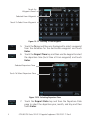
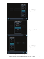
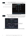
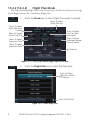
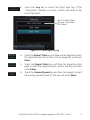
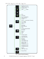
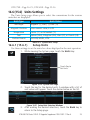
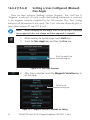
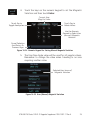
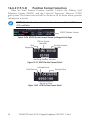
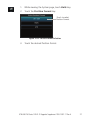
GTN 650/750 SERIES SW V4.10
UPGRADE SUPPLEMENT
The Pilot’s Guides have been revised for SW Version 4.10. This supplement provides
information regarding new features of software version 4.10 for GTN 6XX/7XX Series units.
• GTN 625/635/650 Pilot’s Guide
(Garmin P/N 190-01004-03) Rev E
• GTN 725/750 Pilot’s Guide (Garmin P/N 190-01007-03) Rev E
NOTE: The combination of the following documents is equivalent to the
Pilot’s Guide revisions listed above:
• GTN 650/750 Series SW Version 4.10 Upgrade Supplement
and either
• GTN 625/635/650 Pilot’s Guide
(Garmin P/N 190-01004-03) Rev D
or
• GTN 725/750 Pilot’s Guide (Garmin P/N 190-01007-03) Rev D
Current documents are available at www.garmin.com for free download.
Printed copies may be purchased by contacting Garmin Customer Support.
© 2013 Garmin Ltd. or its subsidiaries. All rights reserved.
This manual reflects the operation of System Software version 4.10, or later. Some differences in operation may be
observed when comparing the information in this manual to later software versions.
Garmin International, Inc., 1200 East 151st Street, Olathe, KS 66062, U.S.A.
Tel: 913/397.8200
Fax: 913/397.8282
Garmin AT, Inc., 2345 Turner Road SE, Salem, OR 97302, U.S.A.
Tel: 503/391.3411
Fax 503/364.2138
Garmin (Europe) Ltd., Liberty House, Bulls Copse Road, Hounsdown Business Park, Southampton,
SO40 9LR, U.K.
Tel. +44 (0) 23 8052 4000
Fax +44 (0) 23 8052 4004
Garmin Corporation, No. 68, Zhangshu 2nd Road, Xizhi Dist., New Taipei City 221, Taiwan
Tel: 886/02.2642.9199
Fax: 886/02.2642.9099
Garmin Singapore Pte. Ltd., 46 East Coast Road, #05-06 Eastgate, Singapore 428766
Tel : (65) 63480378
Fax : ( 65 ) 63480278
At Garmin, we value your opinion. For comments about this guide, please e-mail:
[email protected]
www.garmin.com
Except as expressly provided herein, no part of this manual may be reproduced, copied, transmitted, disseminated,
downloaded or stored in any storage medium, for any purpose without the express written permission of Garmin.
Garmin hereby grants permission to download a single copy of this manual and of any revision to this manual onto a
hard drive or other electronic storage medium to be viewed for personal use, provided that such electronic or printed
copy of this manual or revision must contain the complete text of this copyright notice and provided further that any
unauthorized commercial distribution of this manual or any revision hereto is strictly prohibited.
This part shall comply with Garmin Banned and Restricted Substances document, 001-00211-00.
Garmin®, FliteCharts®, and SafeTaxi® are registered trademarks of Garmin Ltd. or its subsidiaries. These trademarks
may not be used without the express permission of Garmin.
NavData® is a registered trademark of Jeppesen, Inc.; StormScope® and SkyWatch® are registered trademarks of L-3
Communications; Sirius and XM are trademarks of SiriusXM Radio Inc.; Iridium® is a registered trademark of Iridium
Communications Inc.; United States radar data provided by NOAA; European radar data collected and provided by
Meteo France. SD and SDHC Logos are trademarks of SD-3C, LLC.
March 2013
Printed in the U.S.A
TABLE OF CONTENTS
15.4 (14.4)Trip Planning.................................................................................... 1
15.4.1 (14.4.1) Point-To-Point Mode.......................................................... 3
15.4.2 (14.4.2) Flight Plan Mode............................................................... 8
15.5 (14.5) Fuel Planning................................................................................ 11
15.5.1 (14.5.1) Point-To-Point Mode........................................................ 12
15.5.2 (14.5.2) Flight Plan Mode............................................................. 15
15.6 (14.6) DALT/TAS/Winds........................................................................... 17
16.6 (15.6) Units Settings................................................................................ 23
16.6.1 (15.6.1) Setup Units ..................................................................... 23
16.6.2 (15.6.2) Setting a User-Configured (Manual) Nav Angle................. 24
16.6.3 (15.5.3) Position Format Selection................................................. 26
The initial section numbers reflect the sections in the GTN 7XX Pilot’s Guide.
The section numbers in parentheses reflect the sections in the GTN 6XX
Pilot’s Guide.
GTN 650/750 Series SW V4.10 Upgrade Supplement 190-01007-11 Rev A
i
This page intentionally left blank
ii
GTN 650/750 Series SW V4.10 Upgrade Supplement 190-01007-11 Rev A
GTN 7XX - Page 15-12, GTN 6XX - Page 14-12
15.4 (14.4) Trip Planning
The GTN 7XX allows the pilot to view desired track (DTK), distance (DIS),
estimated time en route (ETE), en route safe altitude (ESA) and estimated time of
arrival (ETA) information for a direct-to, point-to-point between two specified
waypoints or for any programmed flight plan. This item also displays the
sunrise/sunset times for your destination waypoint (for the selected departure
date). All times are based on the time set in System-Setup. For trip planning
inputs: departure time and date are manually entered, while ground speed can
be provided by sensor data, if selected.
The trip statistics are calculated based on the selected starting and ending
waypoints and the trip planning inputs.
In Flight Plan mode with a stored flight plan selected, and the entire flight
plan (CUM) selected, the waypoints are the starting and ending waypoints of the
selected flight plan.
In Flight Plan mode with a stored flight plan selected, and a specific leg
selected, the waypoints are the endpoints of the selected leg.
In Point-To-Point mode these are manually selected waypoints (if there is an
active flight plan, these default to the endpoints of the active leg).
Some of the calculated trip statistics are dashed when the selected leg of the
active flight plan has already been flown.
• Desired Track (DTK) - DTK is shown as nnn° and is the desired track
between the selected waypoints. It is dashed unless only a single leg is
selected.
• Distance (DIS) - The distance is shown in tenths of units up to 99.9, and
in whole units up to 9999.
• Estimated time en route (ETE) - ETE is shown as hours:minutes until less
than an hour, then it is shown as minutes:seconds.
• Estimated time of arrival (ETA) - ETA is shown as hours:minutes and is
the local time at the destination.
- If in Point-To-Point mode then the ETA is the ETE added to the
departure time.
- If a flight plan other than the active flight plan is selected it shows the
ETA by adding to the departure time all of the ETEs of the legs up
GTN 650/750 Series SW V4.10 Upgrade Supplement 190-01007-11 Rev A
1
to and including the selected leg. If the entire flight plan is selected,
then the ETA is calculated as if the last leg of the flight plan was
selected.
- If the active flight plan is selected the ETA reflects the current position
of the aircraft and the current leg being flown. The ETA is calculated
by adding to the current time the ETEs of the current leg up to and
including the selected leg. If the entire flight plan is selected, then
the ETA is calculated as if the last leg of the flight plan was selected.
• En Route safe altitude (ESA) - The ESA is shown as nnnnnFT.
• Destination sunrise and sunset times - These times are shown as
hours:minutes and are the local time at the destination.
NOTE: The capability of using Sensor Data is available in SW Versions
2.00, 4.10, and later.
2
GTN 650/750 Series SW V4.10 Upgrade Supplement 190-01007-11 Rev A
15.4.1 (14.4.1)
Point-To-Point Mode
The Trip Planning Point-to-Point mode shows trip calculations between two
selected points: either two waypoints from the database or from your present
position to a selected waypoint.
1. While viewing the Utilities page, touch the Trip Planning key.
2. Touch the Mode key to toggle to Point-to-Point.
3. Touch the P.POS key to toggle between using your present
position as the From waypoint when selected or a waypoint
selected from the database when P.POS is deselected. If P.POS
is selected, the Lat/Lon of the present position will be shown
in the From position.
Touch To Use
Present Position
As Departure
Point
Touch To Toggle
Sensor Data Use
Touch To Select
Departure Time
Lat/Lon Of Present
Position
Touch To Select
Arrival Waypoint
Touch To Select
P-to-P or Flight
Plan Mode
Touch To Select
Departure Date
Trip Statistics
Figure 15-14 Utility Trip Planning Page (Point-To-Point Mode) - Sensor Data Used
4. If P.POS is not selected for the From point, touch the From
key and then use the keypad to select a waypoint from the
database and touch Enter.
GTN 650/750 Series SW V4.10 Upgrade Supplement 190-01007-11 Rev A
3
Touch For
Waypoint Search
Selected From Waypoint
Touch To Select From Waypoint
Figure 15-15 Selecting a From Waypoint
5. Touch the To key and then use the keypad to select a waypoint
from the database for the destination waypoint and touch
Enter.
6. Touch the Depart Time key and then use the keypad to select
the departure time (local time at From waypoint) and touch
Enter.
Selected Departure Time
Touch To Select Departure Time
Figure 15-16 Selecting Departure Time
7. Touch the Depart Date key and then the Departure Date
page to select the departure year, month, and day and then
touch Enter.
4
GTN 650/750 Series SW V4.10 Upgrade Supplement 190-01007-11 Rev A
Touch To Select
Departure Year
Touch To Select
Departure Month
Touch To Select
Departure Day
Figure 15-17 Selecting Departure Date
GTN 650/750 Series SW V4.10 Upgrade Supplement 190-01007-11 Rev A
5
8. Touch the Ground Speed key and then the keypad to select
the average ground speed for the trip and touch Enter.
Selected Ground Speed
Touch To Select Ground Speed
Figure 15-18 Selecting Expected Average Ground Speed
9. After completing the Trip Planning selections, the trip statistics
will be shown in the lower half of the display. In the GTN 6XX,
touch the Compute Data key to display the trip statistics.
Trip Statistics For
Selected Route
Figure 15-19 Utility Trip Planning Page With Computed Data (Point-To-Point Mode)
6
GTN 650/750 Series SW V4.10 Upgrade Supplement 190-01007-11 Rev A
Use Sensor
Data Selected
Ground Speed
Set By Sensor
Data
Trip Statistics For
Selected Route
Figure 15-20 Utility Trip Planning Page With Computed Data (Point-To-Point Mode) - Use
Sensor Data Selected
NOTE: When Local Time is selected in the Setup-Date/Time feature, Sunrise/
Sunset calculations in the Trip Planning feature are based on the From
waypoint time zone. For instance, a flight plan originating in the Pacific
time zone and ending in the Central time zone would show Sunset/Sunrise
times at the destination in Pacific time. This potential offset does not occur
when UTC time is used.
GTN 650/750 Series SW V4.10 Upgrade Supplement 190-01007-11 Rev A
7
15.4.2 (14.4.2)
Flight Plan Mode
The Trip Planning Flight Plan mode shows trip calculations between two legs
of the flight plan or the cumulative flight plan.
1. Touch the Mode key to select Flight Plan mode, if required.
Touch To Select
Flight Plan Leg
Touch To Select
Flight Plan From
Catalog
Touch To Select
P-to-P or Flight
Plan Mode
Select To Toggle
Sensor Data Use
Touch To Select
Expected Average
Ground Speed
Touch To Select
Departure Time
Touch To Select
Departure Date
Trip Statistics
Figure 15-21 Utility Trip Planning Page (Flight Plan Mode)
2. Touch the Flight Plan key to select the flight plan.
Touch To Select
Flight Plan (Active
FPL Shown)
Touch To Scroll List
Figure 15-22 Select Flight Plan
8
GTN 650/750 Series SW V4.10 Upgrade Supplement 190-01007-11 Rev A
3. Touch the Leg key to select the flight plan leg. If the
“Cumulative” selection is chosen, statistics will relate to the
entire flight plan.
Touch To Select Flight
Plan Leg (Cumulative
FPL Shown)
Figure 15-23 Select Flight Plan Leg
4. Touch the Depart Time key and then use the keypad to select
the departure time (local time at From waypoint) and touch
Enter.
5. Touch the Depart Date key and then the Departure Date
page to select the departure year, month, and day and then
touch Enter.
6. Touch the Ground Speed key and then the keypad to select
the average ground speed for the trip and touch Enter.
GTN 650/750 Series SW V4.10 Upgrade Supplement 190-01007-11 Rev A
9
7. Statistics for the current flight plan leg are displayed in the
lower half of the display. In the GTN 6XX, touch the Compute
Data key to display the trip statistics.
Touch To View
Statistics For
Previous FPL Leg
Touch To View
Statistics For
Next FPL Leg
Trip Statistics
Figure 15-24 Utility Trip Planning Page Computed Data View (Flight Plan Mode)
Use Sensor
Data Selected
Ground Speed
Set By Sensor
Data
Trip Statistics For
Selected Route
Figure 15-25 Utility Trip Planning Page Computed Data View (Flight Plan Mode) Use Sensor Data Selected
8. Touch the Next key to view statistics for the next leg in the
flight plan.
10
GTN 650/750 Series SW V4.10 Upgrade Supplement 190-01007-11 Rev A
15.5 (14.5) Fuel Planning
Fuel Planning — This item displays fuel conditions along the active
direct-to or flight plan. You may manually enter fuel flow, ground speed
(GS) and fuel on board figures for planning purposes. Fuel planning figures
can be displayed not only for the currently active flight plan or direct-to,
but also point-to-point between two specified waypoints and for any programmed flight plan.
Fuel on board and fuel flow may be manually entered in the unit start-up
sequence and used to recalculate fuel on board as it is consumed. When fuel
flow or fuel on board is manually entered, the figures are retained the next time
you view the page (with fuel on board continuously recalculated).
NOTE: The capability of using Sensor Data is available in SW Versions
2.00, 4.10, and later.
Use Sensor Data
Selected
Selected
Distance
Measured
Flight Time
Available With
Remaining Fuel
At Destination
Flight Time
Available With
Existing Fuel
Fuel Required For
the Flight Plan
Range With
Existing Fuel
Fuel Usage Rate
Remaining Fuel
At Destination
Figure 15-26 Utility Fuel Planning Page (Flight Plan Mode) - Use Sensor Data Selected
GTN 650/750 Series SW V4.10 Upgrade Supplement 190-01007-11 Rev A
11
15.5.1 (14.5.1)
Point-To-Point Mode
The Fuel Planning Point-to-Point mode shows fuel calculations between two
selected points: either two waypoints from the database or from your present
position to a selected waypoint.
1. While viewing the Utilities page, touch the Fuel Planning
key.
2. Touch the Mode key to toggle to Point-to-Point.
3. Touch the P.POS key to toggle between using your present
position as the From waypoint when selected or a waypoint
selected from the database when P.POS is deselected. If P.POS
is selected, the Lat/Lon of the present position will be shown
in the From position.
Touch To Use
Present Position
As Departure
Point
Use Sensor Data
Selected
Lat/Lon Of Present
Position
Touch To Select
Arrival Waypoint
Touch To Select
P-to-P or Flight
Plan Mode
Fuel Statistics
Figure 15-27 Utility Trip Planning Page (Point-To-Point Mode) - Use Sensor Data Selected
12
GTN 650/750 Series SW V4.10 Upgrade Supplement 190-01007-11 Rev A
4. If P.POS is not selected for the From point, touch the From
key and then use the keypad to select a waypoint from the
database and touch Enter.
Touch For Waypoint Search
Selected From Waypoint
Touch To Select From Waypoint
Figure 15-28 Selecting the From Waypoint
5. Touch the To key and then use the keypad to select a waypoint
from the database for the destination waypoint and touch
Enter.
6. Touch the Fuel on Board key and then use the keypad to
select the current amount of fuel on board and touch Enter.
Selected Fuel On
Board Value
Touch To Select Fuel On
Board Value
Figure 15-29 Selecting Current Fuel On Board
GTN 650/750 Series SW V4.10 Upgrade Supplement 190-01007-11 Rev A
13
7. Touch the Fuel Flow key and then use the keypad to select
the average fuel flow and touch Enter.
Selected Fuel
Flow Value
Touch To Select Fuel Value
Figure 15-30 Selecting Fuel Flow
8. Touch the Ground Speed key and then the keypad to select
the average ground speed for the trip and touch Enter.
Selected Ground
Speed Value
Touch To Select
Ground Speed Value
Figure 15-31 Selecting Ground Speed
14
GTN 650/750 Series SW V4.10 Upgrade Supplement 190-01007-11 Rev A
15.5.2 (14.5.2)
Flight Plan Mode
The Fuel Planning Flight Plan mode shows fuel calculations between two legs
of the flight plan or the cumulative flight plan.
1. Touch the Mode key to select Flight Plan mode, if required.
Touch To Select
Flight Plan Leg
Touch To Select
Flight Plan From
Catalog
Use Sensor Data
Selected
Touch To Select
P-to-P or Flight
Plan Mode
Touch To Select
Next FPL Leg
Touch To Select
Previous FPL Leg
Fuel Statistics
Figure 15-32 Utility Fuel Planning Page (Flight Plan Mode)
2. Touch the Flight Plan key to select the flight plan.
Touch To Select
Flight Plan (Active
FPL Shown)
Touch To Scroll List
Figure 15-33 Select Flight Plan
GTN 650/750 Series SW V4.10 Upgrade Supplement 190-01007-11 Rev A
15
3. Touch the Leg key to select the flight plan leg. If the
“Cumulative” selection is chosen, statistics will relate to the
entire flight plan.
Touch To Select Flight
Plan Leg (Cumulative
FPL Shown)
Figure 15-34 Select Flight Plan Leg
4. If desired, touch the Fuel on Board key and then use the
keypad to select the Fuel on Board value and touch Enter.
5. If desired, touch the Fuel Flow key and then use the keypad
to select the Fuel Flow value and touch Enter.
6. Touch the Ground Speed key and then the keypad to select
the average ground speed for the trip and touch Enter.
7. Statistics for the current flight plan leg are displayed in the
lower half of the display. In the GTN 6XX, touch the Compute
Data key to display the trip statistics.
8. Touch the Previous and Next keys to view statistics for the
previous and next legs in the flight plan.
16
GTN 650/750 Series SW V4.10 Upgrade Supplement 190-01007-11 Rev A
15.6 (14.6) DALT/TAS/Winds
Density Alt / TAS / Winds — indicates the theoretical altitude at which
your aircraft performs depending upon several variables, including indicated
altitude (Indicated ALT), barometric pressure (BARO) and total air temperature (TAT; the temperature, including the heating effect of speed, read on
a standard outside temperature gauge). This item computes true airspeed
(TAS) and density altitude, based upon the factors above. Also, this feature
determines winds aloft — the wind direction and speed — and a head
wind/tail wind component, based on true airspeed, aircraft heading (HDG)
and ground speed. When a FADC provides pressure altitude and the Use
Sensor Data option is selected, the Baro key will not be present in the edit
mode and the Baro indication will not be shown in computed results.
Touch To Select Baro Pressure
Touch To Select
Indicated Altitude
Touch To Toggle
Sensor Data Use
TRK, HDG, &
GS Statistics
Touch To Select
Calibrated Air
Speed
Touch To Select
Total Air Temp
DALT, TAS, and
Winds Statistics
Figure 15-35 Utility DALT/TAS/Winds Page Using Indicated Altitude and Not Using Sensor Data
Touch To Select
Indicated Altitude
Touch To Toggle
Sensor Data Use
TRK, HDG, &
GS Statistics
DALT, TAS, and
Winds Statistics
Figure 15-36 Utility DALT/TAS/Winds Page Using Sensor Data and Pressure Altitude
GTN 650/750 Series SW V4.10 Upgrade Supplement 190-01007-11 Rev A
17
NOTE: The capability of using Sensor Data is available in SW Versions
2.00, 4.10, and later.
Touch To Select Baro Pressure
Touch To Select
Indicated Altitude
Touch To Toggle
Sensor Data Use
Touch To Select
Track Value
Touch To Select
Heading Value
Touch To Select
Calibrated Air
Speed
Touch To Select
Total Air Temp
Touch To Select
Ground Speed
DALT, TAS, and
Winds Statistics
Figure 15-37 Utility DALT/TAS/Winds Page Using Manually Entered Data
1. Touch the Indicated ALT key and then the keypad to select
the Indicated Altitude and then touch Enter.
Selected
Indicated
Altitude Value
Touch To Clear
Values
Touch To Select
Indicated
Altitude Value
Touch To
Select Above
Or Below Sea
Level
Figure 15-38 Select Indicated Altitude Value
18
GTN 650/750 Series SW V4.10 Upgrade Supplement 190-01007-11 Rev A
2. Touch the BARO key and then the keypad to select the
Barometric Pressure and then touch Enter.
Selected Barometric
Pressure Value
Touch To Clear
Values
Touch To Select
Barometric Pressure
Value
Touch To Cancel
Selection
Figure 15-39 Select Barometric Pressure Value
3. Touch the CAS key and then the keypad to select the Calibrated
Air Speed and then touch Enter.
Selected Calculated
Air Speed Value
Touch To Clear
Values
Touch To Select
Calculated Air
Speed Value
Touch To Cancel
Selection
Figure 15-40 Select Calculated Air Speed Value
GTN 650/750 Series SW V4.10 Upgrade Supplement 190-01007-11 Rev A
19
4. Touch the TAT key and then the keypad to select the Total Air
Temperature and touch Enter.
Selected Total
Air Temperature
Value
Touch To Clear
Values
Touch To
Select Total Air
Temperature
Value
Touch To
Select Above
Or Below 0
Degrees
Touch To Cancel
Selection
Figure 15-41 Select Total Air Temperature Value
5. Touch the TRK key and then the keypad to select the Track
Angle and then touch Enter.
Selected Track
Angle Value
Touch To Clear
Values
Touch To Select
Track Angle
Value
Touch To Cancel
Selection
Figure 15-42 Select Track Angle Value
20
GTN 650/750 Series SW V4.10 Upgrade Supplement 190-01007-11 Rev A
6. Touch the HDG key and then the keypad to select the Heading
value and then touch Enter.
Selected
Heading Value
Touch To Clear
Values
Touch To Select
Heading Value
Touch To Cancel
Selection
Figure 15-43 Select Heading Value
7. Touch the Ground Speed key and then the keypad to select
the average ground speed for the trip and then touch Enter.
GTN 650/750 Series SW V4.10 Upgrade Supplement 190-01007-11 Rev A
21
GTN 7XX - Page 16-2, GTN 6XX - Page 15-2
Serial No. & Sys ID
SW/HW Version Info
Database Info
SBAS
WAAS
CDI
Date/Time
Com Chnl Spacing
Nearest Airport
Crossfill
Arrival Destination Proximity
Class B/TMA
Class C/TCA
Class D
Restricted
MOA (Military)
Other
Airspace Altitude Buffer
Nav Angle
Mag Var
Temp
Fuel
Position Format
Low-Wing Prop
High-Wing Prop
Kit Plane
Turboprop
Twin-Engine Prop
Single-Engine Jet
Business Jet
2-Blade Rotorcraft
3-Blade Rotorcraft
4-Blade Rotorcraft
Volume
TAWS Alert Voice
Manual Offset
16-2 System Function Summary
22
GTN 650/750 Series SW V4.10 Upgrade Supplement 190-01007-11 Rev A
GTN 7XX - Page 16-25, GTN 6XX - Page 15-26
16.6 (15.6) Units Settings
The Units Setup page allows you to select the conventions for the various
units that are displayed.
Units Type
Units Values
Nav Angle
Magnetic (°), True (°T), User (°u)
Magnetic Variation
Enter numeric value, E or W
Temperature
Fuel
Celsius (°C) or Fahrenheit (°F)
Gallons (GAL), Kilograms (KG), Liters (LT), or Pounds (LB)
Position Format
LAT/LON, MGRS, UTM
Table 16-2 System Units Setup
16.6.1 (15.6.1)
Setup Units
Use these settings to set the units for values displayed in the unit operation.
1. While viewing the System page, touch the Units key.
Touch Key to
Set Units
Figure 16-30 System Units Page
2. Touch the key for the desired units. A window with a list of
unit values will appear. Touch the desired value on the list.
Figure 16-31 Setup Units Selection Windows
3. After making the desired selections, touch the Back key to
return to the Setup page.
GTN 650/750 Series SW V4.10 Upgrade Supplement 190-01007-11 Rev A
23
16.6.2 (15.6.2)
Setting a User-Configured (Manual)
Nav Angle
There are three variation (heading) options: Magnetic, True, and User. If
“Magnetic” is selected, all track, course and heading information is corrected
to the magnetic variation computed by the GPS receiver. The “True” setting
references all information to true north. The “User” selection allows the pilot to
enter values between 0º and 179º E or W.
NOTE: When changing the Nav angle, the DTK on the Flight Plan page
for an approach does not change until that approach is reloaded.
1. While viewing the System page, touch Units key.
2. Touch the Nav Angle key and then the User key.
Touch to select User
(manual) mag var
Figure 16-32 Nav Angle Selections
3. After User is selected, touch the Magnetic Variation key to
set the value.
Touch to set
manual mag var
Figure 16-33 Magnetic Variation is Available for Editing
24
GTN 650/750 Series SW V4.10 Upgrade Supplement 190-01007-11 Rev A
4. Touch the keys on the numeric keypad to set the Magnetic
Variation and then touch Enter.
Current User
Mag Var Value
Touch Key to
Delete Values
Touch Key to
Toggle Hemisphere
Use the Numeric
Keypad to Select User
(manual) Magnetic
Variation
Cancel Selection
And Return To
Previous Page
Figure 16-34 Numeric Keypad for Setting Manual Magnetic Variation
5. The User Nav Angle value will be used for all angular values.
Remember to change the value when traveling to an area
requiring another value.
Selected User (manual)
Magnetic Variation
Figure 16-35 User (Manual) Magnetic Variation
GTN 650/750 Series SW V4.10 Upgrade Supplement 190-01007-11 Rev A
25
16.6.3 (15.5.3)
Position Format Selection
There are three Position Formats available: Lat/Lon, the Military Grid
Reference System (MGRS), and the Universal Transverse Mercator (UTM)
grid system. The format selected will be shown in all locations where position
information is shown.
NOTE: The Position Format Selection function is available in SW Versions
4.10, and later.
MGRS Position Format
Figure 16-36 MGRS Position Format Shown On Waypoint Info Page
Grid
Designator
100 km Square
Identifier
Easting Numeric
Location
Northing Numeric Location
Figure 16-37 MGRS Position Format Detail
Grid Zone
Latitude Band
Easting Value
Northing Value
Figure 16-38 UTM Position Format Detail
26
GTN 650/750 Series SW V4.10 Upgrade Supplement 190-01007-11 Rev A
1. While viewing the System page, touch Units key.
2. Touch the Position Format key.
Touch to select
Position Format
Figure 16-39 Position Format Selection
3. Touch the desired Position format.
GTN 650/750 Series SW V4.10 Upgrade Supplement 190-01007-11 Rev A
27
This page intentionally left blank
28
GTN 650/750 Series SW V4.10 Upgrade Supplement 190-01007-11 Rev A
© 2013 GARMIN Corporation
GARMIN International, Inc.
1200 East 151st Street, Olathe, Kansas 66062, U.S.A.
Tel. 913/397.8200 or 866/739.5687
Fax 913/397.8282
Garmin AT, Inc.
2345 Turner Rd., S.E., Salem, Oregon 97302, U.S.A.
Tel. 503/581.8101 or 800/525.6726
Fax. 503/364.2138
Garmin (Europe) Ltd.
Liberty House, Bulls Copse Road, Hounsdown Business Park,
Southhampton, SO40 9LR, U.K.
Tel. +44 (0) 23 8052 4000
Fax +44 (0) 23 8052 4004
GARMIN Corporation
No. 68, Jangshu 2nd Road, Shijr, Taipei County, Taiwan
Tel. 886/2.2642.9199
Fax 886/2.2642.9099
Garmin Singapore Pte. Ltd.
46 East Coast Road, #05-06 Eastgate
Singapore 428766
Tel. (65) 63480378 Fax (65) 63480278
www.garmin.com
https://fly.garmin.com/fly-garmin
March 2013
190-01007-11 Rev A