1
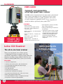
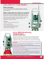
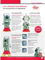
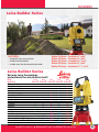
scanners
HDS 6200
Compact, next-generation,
ultra-high speed laser scanner
HDS6200 unlocks the potential of ultra-high speed, “phase-based”
laser scanning technology for fast, productive as-built surveys.
“Next-generation” advances in speed, portability, data quality
at range, temperature capabilities and tilt sensor integration all
combine to deliver significantly lower project costs.
FEATURES
TRADE-INS
AVAILABLE
• Higher accuracy – high distance and angle accuracy
• Full integration: scanner, controller, data storage and batter
• Less noise – major reductions in scan data noise
• Setting up and moving the scanner is fast and easy
• Higher sensitivity – can better detect • Operate the scanner from a simple, side touch panel. An optional PDA
laser returns
or laptop with Leica Cyclone SCAN
• Higher scan density – increases the software provide added scanner
range
control and valuable field QA.
• Scan speed – up to 1,016,727 Wireless LAN (WLAN) is also fully
points per second
integrated
• Added context – the ability to calculate return data out to 79 m
Leica C10 Scanner
INOVx RealityLINx
Software Available
The all-in-one laser scanner
Today, the most popular class of laser scanner
— ScanStation™ is now in a compact, all-in-one
ScanStation C10 platform. It features major productivity
advances, including a Smart X-Mirror™ that lets users
conduct full-dome (360°X270°) scans in just minutes.
FEATURES:
• A dual-axis compensator
• Interface total station prisms, GPS SmartAntenna
• On board graphic controller with data storage
• Powerful camera/video
• Hot swap batteries
• Tribrach with laser plummet
• Optional Wi-Fi connection for laptops
• Up to 10x faster full dome scans: now, just minutes
• Move, setup and tear-down faster
• Up to 90% field labor savings vs traditional methods
• Designed for incremental upgradeability
4
Local Presence
National Reach
Global Resources
monitoring
Leica TS30 0.5” Total Station
Pride in Accuracy
This total station redefines precise surveying by offering unmatched
accuracy and quality. Surveyors with demanding tasks do not need to
make compromises.
When compromises are simply not accepted
The TS30 total station is ready for any challenge. Surveyors take great
pride in accuracy. The Leica TS30 delivers impressive performance. More
importantly it is a champion in perfectly combining angle measurement,
distance measurement, automatic target recognition and motorization.
The accuracy of the Leica TS30 is in a league of its own, a true
companion for surveyors with pride.
FEATURES:
• Angular accuracy – 0.5” Pinpoint EDM accuracy
• 0.6 mm + 1 ppm to prism
• 2 mm + 2 ppm to any surface
• Automatic Target Recognition (ATR) accuracy – 1”
• World’s best Dynamic Tracking Performance
• Fastest Start-to-Finish Workflow
Leica TM30 Monitoring
Total Station
Every half second counts
Combination of speed and accuracy allows engineers to effectively and cost
efficiently measure and control vital infrastructures. Outstanding reliability and robust design with experience in high precision sensor technology. The
combination of SmartEye vision technology and unique direct drive technology
provides faster, more precise and longer range measurements than ever before.
FEATURES:
High accuracy angular measurement – The TM30 offers 0.5” or 1” angular accuracy, ensuring that the highest accuracy standards are met every time.
SmartEye vision – The TM30 includes SmartEye vision technology to automatically measure targets up to 3000m with millimeter accuracy. This advanced technology enables large areas
to be monitored with a single instrument.
Unique high precision PinPoint EDM – Measure targets with higher accuracy than ever before with next generation PinPoint EDM technology. Features a unique precision of 0.6 mm +
1ppm to prisms and 2 mm + 2 ppm to natural surfaces.
Leica TM30
Accurate, Fast and Silent
Move, Lock, Measure, Transmit – The TM30 quickly moves with unmatched speed to monitor points. SmartEye vision then effortlessly locks onto the prism. The long-range
PinPoint EDM is harmonized with precise angle sensors to complete the measurement
process. Measurement data is available for on-board storage, or to be transmitted to any
location via cable, radio, mobile phone or the internet.
Local Presence
National Reach
Global Resources
The Leica TM30 is designed to meet the highest accuracy standards. High precision
5
system solutions
LEICA
VIVA GNSS & TPS
LEICA VIVA TPS
TPSD1200+
SmartStation
TS15i
SmartPole
GS15
Leica Viva System
Welcome to Leica Viva
A Complete Surveying System
NEW
Surveyors are constantly faced with ever changing circumstances. Changing economic conditions, legal
regulations, the emergence of new technologies and increasing competitive pressure affect their working
environment. Visions arise from the interaction of your experience, your knowledge and your creativity.
The fulfillment of your visions into reality is what makes the profession of a modern surveyor so exciting
– and what makes those who manage this achievement successful.
Solutions for Your Business
Local Presence
LEICA VIVA GNSS
GS10
Zeno 10
National Reach
Global Resources
LEICA VIVA CONTROLLERS & SOFTWARE
BUILT FOR THE FIELD
The field controllers CS10 and CS15 were designed as
part of the Leica Viva series, but are versatile to work
with many instruments and software
combinations.
NetRover
GS15
NetRover
CS15
6
Local Presence
National Reach
CS10
Global Resources
gps
Leica GS10 and GS15
Can’t find a more flexible system
A versatile and proven GNSS System – An
ideal solution for today and tomorrow.
GS15
FEATURES:
• P roven GNSS technology – Reliability and Accuracy
• Smart Check – RTK data processing to guarantee results
• Smart Track – Advanced four constellation tracking of all GNSS satellites today and tomorrow
• Smart RTK – consistent results in all networks
• GS10 and GS15 are built for the most demand environments
• Deliver the hallmarks of Leica GNSS – reliability and accuracy.
– SmartCheck – RTK data-processing to guarantee correct results
– SmartTrack – advanced four constellation tracking of all GNSS satellites today and tomorrow
– SmartRTK – delivers consistent results in all networks
Designed to suit any surveying task.
• Exchangeable communication devices for field base stations and RTK rovers with removable SIM cards (Built-in for GS15)
• Fully scalable sensor allows you to buy only what you need today and upgrade with additional functionality as you need it
• Integrated web server to configure the logging of Leica or RINEX raw data and measure with one button press in the field
• Rugged
CS10
Built for the most
demanding environments.
• IP67 protection against dust and immersion to 1m
• Built for extreme temperatures of -40°C to +65°C
• Integrated intenna technology to avoid breaking, losing or forgetting antenna (for GS15)
Local Presence
National Reach
GS10
Global Resources
7
total station
The World’s
FASTEST
Robotic Imaging
Total Station
Leica TS15i
SPECIAL
LEASE RATES
AVAILABLE
Designed for live streaming
of images to the instrument
and data collector
FEATURES:
• Angle measurements of 1”, 2”, 3”, and 5” with quadruple axis compensation
• In prism mode a distance of 3’500m is achieved with an accuracy of 1mm+1.5ppm on a single prism in standard measuring mode
• Measure up to 1’000 m and more with an accuracy of 2mm + 2ppm
• Add GNSS functionality to the Leica Viva TS11 total station to further improve productivity
• The Viva TS11 can be used as a Leica SmartStation for TPS setup without the need of control points, traverses, and resections
LEICA TS15I FEATURES:
— Best-in-class Imaging
Capture Camera — High-resolution
• Image Notes – Capture an image, screenshot or template, sketch on it and
link it to any object in the database.
camera enhances total station productivity.
Image Capture users can take high-resolution
images of the surveying scene
• Image Assisted Surveying – Simply tap on the display and the total station will turn
and measure the desired target.
— Best-in-class One-PersonSurveying
• Search – PowerSearch finds your prism within seconds
• Lock – Viva TS15 stays locked onto your prism in the most demanding environments
• Measure – PinPoint EDM seamlessly blends with precise angle sensors to complete the
measurement
8
Local Presence
Sketch Tool — captured image can be
enhanced through sketching with any color,
line style and width to uniquely transfer
valuable information.
Linking of Images – After capturing
and sketching, the annotated images can be
linked to any object of interest (point, line,
area) or simply stored with a time stamp.
National Reach
Global Resources
gps
Leica GNSS SmartPole
Surveying Instantly
Leica SmartPole
GS15
Leica SmartPole saves time in both the office and the field. It is no
longer necessary to first measure orientation points and only then detail
points. Simply begin the survey and conduct the setup On-the-Fly while completing the survey. Once the TPS orientation and coordinates are known, all measured points are automatically updated.
FEATURES:
• Flexible Alternatives: Users can survey and stake
out with RTK GPS or the remote total station, or both—whichever is best, depending on the area and the distance to the points to be measured.
• Unconventional Control: With SmartPole, surveyors can establish control
points with RTK and measure to them simultaneously with the total station to resect its position.
• On-the-Fly Measurements: With SmartPole, set up the total station in the
most convenient location, instantly begin the survey and determine the total
station coordinates and orientation On-the-Fly while conducting the survey for CS15
unmatched productivity.
Leica GNSS SmartStation
SmartStation – A Versatile GNSS System
GS15
Just set up Leica SmartStation and let GNSS/GPS determine the position. No need for control points, long
traverses or resections. Then measure and stake out with
the total station. Use TPS and GNSS separately when
required. Put the GS15 Antenna on a pole as an RTK rover or use the TPS as a standard total station.
FEATURES
• Transparent GPS: Once the GS15 GPS Antenna is connected to the TPS1200+, all survey operations are conducted through the total
station keyboard, thus requiring minimal GPS expertise.
• Long range vision: The SmartStation can be located at ranges of up to 50km from a reference station and still provide accurate
positioning (horizontal: 10mm+1ppm; vertical: 20mm+1ppm).
• Incredible versatility: The modular design allows surveyors to use the SmartStation as a total station, RTK GPS rover or both.
Local Presence
National Reach
Global Resources
9
gps
Leica Viva NetRover
The All-In-One GNSS Network Solution
Leica Viva NetRover integrates the latest technology from Leica
Geosystems, the world’s leading measurement solutions provider. All the components of Viva NetRover work seamlessly together,
creating lightweight and cable-free network rovers.
CALL FOR
INTRODUCTORY
PRICING!
TURN-ON
SURVEY IT
STAKE IT
TURN-ON & MEASURE
• Viva NetRover is always ready to measure
• Full support of RTCM3.1 transformation
message positions are automatically
supplied in local coordinates
QUICK TO LEARN
• SmartWorx Viva LT with simplicity in mind
• Clear graphics, logical menus
DESIGNED FOR NETWORKS
• Best in class performance
• Field controller with built-in 3.5G mobile broadband
• Future proof
10
Local Presence
National Reach
Global Resources
gps
Leica GS09 GNSS
Your tasks, your choices,
our solutions
GS09 System
Choose from a wide range of available functions
and applications that you really need to
complete your tasks. By configuring the system
for personal requirements, the investment
cost is minimized and its operation is not
complicated to use.
• Base Station – easily set up RTK base station operates without controller
• RTK Rover – exceptionally rugged and light-weight
pole setup without any cables
• Network Rover – a complete surveying system, operating in all reference networks
• SmartStation – the GS09 fits onto a TPS creating one easy-to-use instrument
• Snap to communication devices
GS09 Controller
• Ergonomic – QWERTY alphanumeric keyboard and function keys for rapid data entry
GS09 ROVER
• Color Display – large display with touch screen functionality
• Removable Memory – up to 1 GB data storage on CompactFlash card
GS09 SmartWorx Field Software
• Based on the proven and familiar operating concept of the system 1200 with new Icon-based Menus – quick to learn, ensuring instant productivity
• Application Programs – enable any survey task to be easily and efficiently completed
• Field-to-Office – transfer data between the work site and the office computer
• Plug and Play – automatic detection of communication
devices for easy setup
CHOOSE
YOUR
SOFTWARE
Carlson
SurvCE
Available
CS09 CONTROLLER
Local Presence
National Reach
Global Resources
11
robotic total stations
LEICA TPS 1200+
The Total Station with the Plus
Leica TPS1200+ is our most competitive total station ever,
providing the most accurate EDM with the smallest laser
dot and measuring distances over 1000 meters.
Plus = Flexibility and Scalability
CALL FOR
SPECIAL
PRICING
With Leica’s SmartStation, SmartRover and
SmartPole options, you can add full GNSS functionality
to your TPS1200+ Total Station whenever you want.
Customize your surveying equipment to your specific
tasks, crews and budget. Combine TPS and GNSS in the
most efficient way. Invest in flexibility while at the same time
increase productivity.
FEATURES:
• Pinpoint Reflectorless Measurement: the built-in telescope allows
surveyors to measure inaccessible or hard-to-reach targets with the smallest
laser dot (2cm at 150ft.) More than 3,000 feet away without reflectors with accuracy up to 2 mm.
• Automatic Target Recongition: with one prism, the tps1200+ has
a guaranteed measurement range of 1.8 Miles, angle accuracy of 2, 3, or 5
second and base positioning accuracy of 1mm.
• Twice As Fast: the tps1200+ achieves angle measurements
in 1 to 5 seconds depending on required accuracy, 50% faster than the competition.
• GPS Compatible: with a quick snap-and-click, the modular
tps1200+ can connect to the leica gps1200 receiver to add full
GPS RTK capabilities.
With Your Choice of Data Collectors
CS10
12
CS15
Local Presence
Allegro MX
National Reach
Global Resources
total stations
Leica Flexline Total Stations
The new generation of Total Stations:
Leica FlexLine TS09
Leica FlexLine TS06
PERFORMANCE GUARANTEED
FLEXIBILITY THAT COUNTS
A true performance Total
Station that continually
delivers regardless however
demanding the task may
be. For mid-to-high accuracy
applications. Equipped with
all FlexLine features from
removable USB memory,
Bluetooth® wireless
technology, Emitting Guide
Light to a complete range of
application software, your
TS09 guarantees maximum
performance.
A Total Station that is ready
for any challenge. Designed for
mid accuracy applications. As
standard, an alpha-numerical
keyboard and a complete set of
application software is included.
For additional flexibility, a wide range of options ensures that you
can always count on your TS06
Total Station.
SPECIAL
LEASE RATES
AVAILABLE
Bluetooth® and USB Option
Leica FlexLine TS02
IDEAL TODAY, PERFECT
TOMORROW
The ideal Total Station for
standard measurement tasks.
Designed especially for midto-low accuracy applications.
It comes complete with a
standard set of application
software. For more
convenience add Bluetooth®
wireless technology to
connect any data collector
and use the Software which
best suits your tasks and
requirements.
Local Presence
National Reach
Bluetooth® cable-free connection
USB memory stick for flexible data transfer
Mini-USB for fast data transfer
Alpha-numerical Keyboard
available
Rapid entry of numbers, letters
and special characters
Minimizes errors
Enhance productivity
Angular Accuracy
2”, 3” or 5”
Quadruple axis
compensation to
guarantee accurate
and reliable angle
measurement
Global Resources
13
digital levels
DNA03 & DNA10 Digital Levels
DNA03 Height measurements with 0.3 mm standard deviation
per km double leveling (invar staff).
DNA10 Height measurements with 0.9 mm standard deviation
per km double leveling (invar staff).
ADVANTAGES THAT MOVE YOU AHEAD:
• LC-display presents all important measured data at a glance and shows the next step directions
• Double your data safety: save your work automatically in the internal memory and, after the
measurement, on a PCMCIA card.
• Alphanumeric keyboard provides the highest levels of efficiency at work, optimum comfort
• Save up to 50% in time with Leica digital levels
• Measuring without mistakes or fatigue
• Geo Office Tools is a program that controls data exchange, the configuration of the instrument,
creates code lists and stake out height lists and
maintains the system software.
DNA03
Item No.
723289
DNA10
Item No.
726540
ACCESSORIES
Item No.
734753
667318
563625
Description
723289 DNA03, 0.3mm, precision digital level, magnetically damped
compensator, with user manual and container
Your Price
Call for Quote
Description
744672 DNA10 Digital Level, Basic Configuration, magnetically damped
compensator, with user manual and container
Your Price
Call for Quote
Description
734753 GKL112, Charger BASIC, for Ni-Mh batteries GEB121 and GEB111,
car adapter cable and net adapter included
667318 Plug-in Camcorder battery GEB111 NiMH, 6V/2.1Ah, rechargeable
(for T100, TPS100/400/700/800, RCS1100)
563625 GEV102, Data transfer cable, connects a TPS or DNA to PC (9-pin RS232 serial), 2m
Your Price
Call for Quote
OFFICE SOFTWARE
Item No.
734711
734723
734722
CERTIFICATION
Item No.
*727257
14
Call for Quote
Call for Quote
Description
734711 LGO Office Software
734723 Design & Adjustment 1O (Requires LGO Office Software)
734722 Level Data Processing (Requires LGO Office Software)
Your Price
Call for Quote
Call for Quote
Call for Quote
Description
727237 Certificate of Insp/DNA03 Level
Your Price
Call for Quote
Local Presence
National Reach
Global Resources
office solutions
Leica Sprinter 50/150(M)/250(M)
Leica Sprinter Electronic Levels
Measurements have never been so easy to perform with the Leica
Sprinter 150, 150M and 250M Electronic Levels. The Leica Sprinter
150, 150M and 250M allow users to perform their job quickly
and efficiently.
FEATURES:
• USB interface (only 150M and 250M)
• User-friendly menu
• Automatic height calculation and delta height
• The right leveling applications
• Built-in memory (only 150M and 250M)
• Built-in tilt warning system
• On-board applications
• Short measuring time
• Protection against dust/water
• Low power consumption with
AA dry cells
• RS232 port for easy interface (optional)
Item No.
764686
762629
762630
762631
741883
Description
Sprinter 50
Sprinter 150
Sprinter 150M
Sprinter 250M
GSS111-1 16.4’ Telescoping Staff
MSLP*
$ 995.00
$1195.00
$1495.00
$1895.00
$ 80.00
Runner 20 and 24
NA700 series
Tough, Accurate, Great Value
Superior Performance,
Superior Value
FEATURES:
• Superior performance at a great price
FEATURES:
• Easy set up
• Easy to Use
• Designed to work hard on job sites
• Targeting is quick
• Accurate with clear, bright optics
• Durable, tough, precise
• Ergonomic Optics
• Configure for multi-purpose
• Double-sided endless
fine drive
• May be mounted on flat
or dome head tripod
• Pentaprism for easy viewing of circular level
• 360° division
• Ideal construction level
Item No.
727585
727586
Description
RUNNER20 Automatic
Level w/ user manual
RUNNER24 Automatic
Level w/ user manual
Local Presence
MSLP*
$299.00
$349.00
Item No. Description
101010 641982 NA720 Automatic
Optical Level w/ user manual
101015 641983 NA724 Automatic
Optical Level w/ user manual
101020 641984 NA728 Automatic
Optical Level w/ user manual
101025 641985 NA730 Automatic
Optical Level w/ user manual
National Reach
Global Resources
MSLP*
APE Price
$495.00 Call for Quote
$695.00 Call for Quote
$895.00 Call for Quote
$995.00 Call for Quote
15
builders
Leica Builder Series
FEATURES:
• Designed for every construction job
• Accelerate work production
• Scalable series that will meet professional needs
Builder 100 Series – Available in 6” and 9”
Builder 200 Series – Available in 6” and 9”
Builder 300 Series – Available in 6” and 9”
Builder 400 Series – Available in 5” and 9”
Builder 500 Series – Available in 3”, 5” and 9”
Leica Builder Series
Because Leica Geosystems
understands the way Builders built!
Builder
Leica
Leica
Leica
Leica
Leica
Specifications
Builder 100 Builder 200 Builder 300 Builder 400 Builder 500
Full Power Site Software
Wireless Communication
Prism Measurement Mode
Full alphanumeric keyboard
Volumes Calculation
Data Im/Export to USB Stick
PC/Handheld Interface
Laser Distance Measure
Control Line Setup
3 Languages
Leveling Aid
Dual Axis Compensator
Laser Plummet
Li-Ion Batteries
Internal Memory [points]
Angular Accuracy
Distance without reflector (90% reflective)
Distance to reflective tape (60mm x 60mm)
Distance to glass prism
Local Presence
3
3
3
3
3
9’’, 6’’
-
3
3
3
3
3
3
3
3
9’’, 6’’
80 m
250 m
-
3
3
3
3
3
3
3
3
3
3
15’000
9’’, 6’’
120 m
250 m
-
National Reach
3
3
3
3
3
3
3
3
3
3
3
3
3
3
3
3
3
3
3
3
3
3
3
3
3
3
50’000
50’000
9’’, 5’’
9’’, 5’’, 3’’
15 m
250 m
15 m
250 m
500 (3500) m 500 (3500) m
Global Resources
17
general construction lasers
Rugby 100/100LR
An automatic self-leveling general construction laser for
exterior jobs of any size, large or small.
Use for:
• Checking grade
• Precise depth control for sub base and fine grade excavation
• Concrete forming, pad placement
• Setting foundations and footings
Item
Description
6003493 Rugby 100 GC Package 6003499 Rugby 100 LR Package MSLP*
$1225.00
$1420.00
Rugby 260SG, 270SG, 280DG
• The Ruby 260SG is a rugged general Construction laser
• The Rugby 270SG is a fully automatic, single grade laser for
general construction
• The Rugby 280DG Multipurpose Plus-A horizontal, vertical and
dual grade for Exterior or Interior use
Item
Description
Your Price
768537 260SG w/Rodeye Plus/Alkaline Batt.
$1640.00
768538 260SG w/Rodeye Plus/Alkaline Batt.
$2295.00
768539 280DG w/Rodeye Plus/Nimh Batt./Remote
$2995.00
Rugby 320SG, 410DG, 420DG
Rugby Grade Lasers are automatic and self-leveling
for jobs large or small. Can be used for any application
involving precise grade control such as:
• Building pads, parking lots and runways
• Precise depth control for sub base and fine grade excavation
• Agricultural usage such as land leveling or tilling
• Concrete forming and framework
• Retention ponds and batters
• Setting foundations and footings
• Compatibility with the widest range of machine control solution
18
Local Presence
National Reach
Global Resources
tripods
Rod-Eye•Digital Rod-Eye•Plus
Rod-Eye•Basic
Features
Features
• Digital Readout
Features
• Deep beep beam finder
• LCD Indication – 2 graphic displays on the front and back of the receiver
• Three bright LED’s
• Working Radius 450 meters (1500 ft.)
• LCD indication – 2 clear displays
• LCD indication – 2 large graphic displays
• Working Radius 150 meters
• Working Radius 450 meters
Item
107967
107968
Description
769809
Rod-Eye Digital w/bracket 769814
Bracket Only Price
$375.00
$ 40.00
Item
107851
107969
Description
769810
Rod-Eye Plus w/bracket 769815
Bracket Only Price
$250.00
Item
Description
107966 769811
Rod-Eye Digital w/bracket Price
$175.00
$ 40.00
Pipe Laser 100, 200
The Leica Piper series of pipe lasers are perfect for:
storm and sanitary sewer construction, gravity flow pipe line and anywhere grade and line are
required with a single beam. Choose
from the Piper 100 or the Piper 200
with Alignmaster.
Smallest pipe laser
on the market!
FITS IN A 4” PIPE
Item
101475 101480 101540
101525
101510
101490
Local Presence
National Reach
Description
748704 Piper 100 Laser Package 748710 Piper 200 Laser Package 745139 Trivet Handle Assembly
746158 Trivet Assembly
725915 Transit Tower Assembly
748900 Piper Accessories Kit
MSLP*
$4395.00
$4895.00
$ 55.00
$ 395.00
$ 860.00
Price
Call for Quote
Call for Quote
Call for Quote
Call for Quote
Call for Quote
$ 323.00 Call for Quote
Global Resources
19
prisms and poles
Seco Prism Bags
Item No.
8201326
8201321
8233582
8207546
823333
8232543
20
Description
Single Prism Bag Org
Triple Prism Bag Org
Triple Prism Bag Grn
Jumbo Triple Prism Bag Org
Jumbo Triple Prism Bag Grn
Extra Tall Triple Prism Bag Org
Local Presence
$
$
$
$
$
$
Price
26.50
28.50
39.95
34.00
55.95
36.00
National Reach
Global Resources
prisms and poles
Leica Prism Poles
Professional
Item No.
385500
54391
754389
667309
667310
Description
GLS11, Telescopic Pole With Circular
Bubble Quick Release Clamp (cm & ft)
GLS12, Telescopic Aluminum Pole With Snap Locks
GLS12F, 2m Telescopic Aluminum Pole, US Feet Graduations
GLS111, Reflector Pole With Bull’s-eye Bubble, cm/ft
Graduation, Extends to 2.60m, With Red/White 0.20m Graduations
GLS112,Reflector Pole With bull’s-eye Bubble, cm/ft
Graduation, Extends to 3.65m,With Red/White 0.20m Graduations
Price
$ 195.00
$250.00
$ 300.00
$245.00
$295.00
Basic
642106
GLS115, Mini Pole Four Screw-Together Sections,
Extends to 1.3m
$85.00
Choice
748967
CPP105, Reflector Pole With Circular Bubble For
Flat-Mini-Prisms, Snap Lock at 1,5m and 2,0m
$130.00
Mini Prisms
403427
GLS14 Mini Reflector Pole For Exact Positioning Over a Mark
GPR113
Target Sold Separately
$100.00
GPH1P
GPR121
GPR111
Standard Reflectors
Professional
Item No.
641617
Description
GPR121, Circular Prism with Holder Precision circular prism with
anti-reflection coating, mounted in metal holder.
Price
$ 365.00
362830
GPR1, Circular Prism Suitable for mounting in GPH1 and GPH3 holders.
$ 240.00
362820
GPH1, Prism Holder for one GPR1 circular prism.
$
70.00
400080
GPH3, Prism Holder for three GPR1 circular prisms.
$
95.00
555631
GPH1P, Precision Reflector The prism is slightly tilted to prevent
any EDM reflection from the front surface, thereby increasing measurement
accuracy. Centring accuracy 0.3mm, max. range with IR of 3500m.
$1655.00
Item No.
641618
Description
GPR111, Circular Prism with Holder Circular prism
Price
$ 195.00
726295
GPR112, Monitoring Prism Large diameter monitoring prism for
long range measurements. For installation on M8 or 5/8” threaded bolts.
$ 120.00
753492
GPR113, Circular Prism with Holder Circular prism mounted in red polymer
holder. Suitable for fitting of the 362823 GZT4 target plate.
$ 185.00
Basic
Local Presence
National Reach
Global Resources
21
tripods
Seco Tripods
Item No.
823319
Description
Heavy Duty Elevator Tripod
Tripod height from 5.97’ to 12.40’ 5321-17
Price
$334.95
Features an adjustable
center column that
gives the tripod
5.97-ft. (1.82-m) of lift
Crain Tri-Max
Item No.
Description
8237809
5/8 x 11 Trimax Quick Clamp
Price
Composite Tripod 90550
8233320
$407.00
5/8 x 11 Heavy Duty Aluminum
Tripod Quick Clamp 22225
8237809
$ 93.00
Leica Tripods
Item No.
726831
738049
667301
394752
399244
328422
726833
563630
Description
CTP101 Wooden Tripod
GST20 Wooden Telescopic Tripod
GST120-9 Wooden Tripod
w/Auto-Locking Leg Mech.
GST20-9 Wooden Tripod
GST05 Wooden Telescopic Tripod
GST40 Aluminum Tripod
CTP103 Aluminum Tripod
GST05L Aluminum Telescopic Tripod
Price
$125.00
$385.00
$350.00
$350.00
$250.00
$650.00
$110.00
$250.00
328422
Leica Tripod
Accessories
Item No.
332200
734163
748417
738049
726833
753314
726831
22
Local Presence
National Reach
Description
GST4, Tripod Star – For the secure
set-up of tripods on slippery surfaces.
GHT43, Tripod Bracket Adapter for
mounting the TCPS27 radio on all tripods.
GHT58, Tripod Bracket Adapter to
mount Leica GFU radios on all tripods.
GST73, Rolling Base Base with
lockable wheels, suitable for all
tripods. Allows tripod to be moved
without removing the instrument.
Global Resources
Price
$195.00
$ 30.00
$ 30.00
$575.00
level rods
Round Shape
Imprinted scales for lifetime wear. Positive locking/
button system and 5/8” x 11” female prism mounting
adaptor. Standard Series – 25’ telescoping heights,
tenths
Item
8201356
8211528
Description
LRSTD 25’ 10th
LRSTD 25’ 8th
Price
$271.95
$271.95
Level Rod Replacement
Sections for LRSTD 25’
Item
8224952
8233136
8224959
Description
0’ - 5’ 10th
5’ - 10’ 10th
91025 Lock Set Complete
Price
$106.00
$ 83.90
$ 48.90
Professional Series
20-45’ telescoping heights, tenths. Larger diameter
sections, bold face scale and is sturdier at tall heights.
Free carrying case.
Item
8233999
Description
LRPRO 25’
Level Rod 10ths
Price
$328.95
Replacement Sections
for LRPRO – 25’
Item
8233135
8233345
Description
0’ - 5’ 10th
5’ - 10’ 10th
Price
$105.95
$103.95
Rectangular
Fiberglass Level Rod
(CR Series) incorporates versatility. Rectangular shape
with rounded back corners provide compatibility with
laser sensors and a large, easy-to-read face.
Item
8209122
8201530
8201532
8202722
8202725
8233027
8201146
Description
CR-08-T 8’ Level Rod – 10ths
CR-08-I 8’ Level Rod – Inches
CR-13-T 13’ Level Rod – 10ths
CR-13-I 13’ Level Rod – Inches
CR-16-T 16’ Level Rod – 10ths
CR-16-I 16’ Level Rod – Inches
91411 Carry Case F/CR13-16
Local Presence
Price
$52.95
$52.95
$74.95
$74.95
$93.95
$93.95
$17.95
National Reach
Global Resources
23
locators
Leica Locators
The Digicat 500i and 550i represent the latest
design in cable location technology. With
state-of-the-art digital signal processing (DSP)
and intelligent software, the Digicat i-Series
locators make ground surveys a simple and
speedy task; increasing onsite safety and
ultimately saving time and money.
The Digicat 500i and 550i locate
buried conductive services by receiving
electromagnetic signals which radiate from
them. The Digicat’s software interprets the
signals and provides the operator with an
audible and visual response to the position
and direction of the buried services.
Item
Description
Price
780231
Digicat 500i
Call for Quote
8224975
MT100 Soft Case
$ 980.00
8224972
MT101 Soft Case
$ 888.00
8224973
MT102 Soft Case
$1073.00
Schonstedt’s Locators
7-year
Warranty
Set standards for reliability
and dependability
GA52-CX
Locates survey boundary markers, valves, iron
pipes, P.K. Nails, etc. Features loudspeaker, on/off
volume & 4 sensitivity settings, supplied with two 9V
batteries
Item
8207349
8224970
Description
GA52CX w/hard case
Headset
Five models
to fit your
needs!
Price
$ 917.00
$ 50.00
GA72-CD
New 72 series model features digital readouts, graphs,
audio signal and sensitivity control. Uses two each 9V
lithium batteries and has a 5-year warranty with return
of warranty card.
Item
8209201
24
Description
GA-72CD w/hard case
Local Presence
Price
$1041.00
5-year
Warranty
National Reach
Global Resources