1
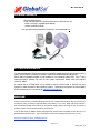
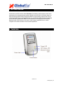
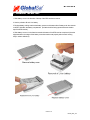
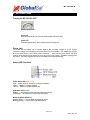
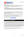
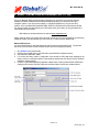
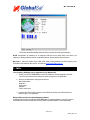
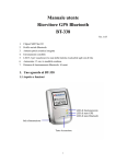
BT-338 GPS User’s Guide v2.2
Bluetooth GPS Receiver
DOCUMENT REVISIONS
REV NO.
DATE
1.0
02-28-2003
2.0
04-07-2005
2.1
04-20-2005
2.2
03-17-08
DESCRIPTION
Initial document
New document format
Modified FAQ section
Updated specs
APPROVED
BRF
AAK
AAK
EDM
© 2006 Globalsat Technology Corporation/USGlobalsat, Inc. All rights reserved. The Globalsat logo is a trademark
of Globalsat Corporation. Windows is a register trademark of Microsoft Corporation. Acrobat is a registered
trademark of Adobe Systems Incorporated. Mac is a registered trademark of the Apple Corporation. All other
trademarks or registered trademarks are acknowledged as the exclusive property of their respective owners.
All rights reserved. No part of this manual may be reproduced, transmitted, copied, or stored in any storage
medium, for any purpose, without prior written consent from Globalsat Technology Corporation or USGlobalsat, Inc.
Globalsat/USGlobalsat hereby grants the right to download one (1) copy of this manual onto a hard drive for
personal use. This manual is copyrighted and may contain proprietary information that is subject to change without
notice.
BT-338 GPS
Table of Contents
PACKAGE CONTENTS.............................................................................................................3
SYSTEM REQUIREMENTS......................................................................................................3
WELCOME ..................................................................................................................................3
1. GETTING STARTED ............................................................................................................4
2. THE BT-338............................................................................................................................4
3. CHANGING THE BATTERY................................................................................................5
4. GPS FUNCTIONS..................................................................................................................6
5. INITIALIZING YOUR GPS RECEIVER...............................................................................7
6. USING / TESTING YOUR GPS RECEIVER (WIN / PPC only).......................................8
7. FAQ’s ......................................................................................................................................9
8. CONTACT INFORMATION ...............................................................................................11
9. SAFETY AND LEGAL NOTICES ......................................................................................11
10. LIMITED WARRANTY.......................................................................................................12
11. BT-338 SPECIFICATIONS ..............................................................................................13
PAGE 2 OF 13
BT338_GPS_v2.0
BT-338 GPS
PACKAGE CONTENTS
- Bluetooth GPS Receiver
- Driver CD-ROM with User’s Guide and test utility for WIN and Mac O/S*
- 12VDC car charger (cigarette lighter adapter)
- 110VAC home/office charger
*Your can also download Installation Guides from: www.usglobalsat.com
SYSTEM REQUIREMENTS
The Globalsat Bluetooth GPS receivers requires a Bluetooth enabled device that can accept accessory
pairing, such as PDA’s, Smartphones, laptops or Laptops with added Bluetooth USB dongles. .
rd
Also a NMEA compatible navigation or map software for your operating system (O/S). Your 3 party
mapping/navigation software may have its own system requirements, please check with software
vendor for details.
A computer with a CD-ROM drive is only required to view the Users Guide, or load the test utility
program for wither Windows or Mac operating systems. These files and programs are also available
for download directly from our web-site at: http://www.usglobalsat.com
WELCOME
Thank you for purchasing a Globalsat Bluetooth GPS receiver! Globalsat GPS receivers allow for real-time street
navigation by using your laptop for graphical plotting and positioning of your route. Simply pair the GPS receiver,
with your Bluetooth enabled device, install your own personal mapping software, and begin to view your position in
real-time in relation to the surrounding streets in your travel area.
You’ll find that almost any NMEA compliant mapping/charting software will be compatible with the data from your
Globalsat Bluetooth GPS receiver.. Visit our web-site for recommended mapping programs that you can use.
http://www.usglobalsat.com/faq_details/Mapchart.asp
PAGE 3 OF 13
BT338_GPS_v2.0
BT-338 GPS
1. GETTING STARTED
Globalsat Bluetooth GPS receivers utilize a Bluetooth (short distance wireless protocol) and a built-in
active antenna for high signal tracking sensitivity. Based on the SiRF Star III Low Power chipset, our
GPS receivers support all functions (single sat updates in reduced visibility, superior urban canyon
performance, foliage lock for weak signal tracking, etc.). Our Bluetooth GPS receivers are well suited
for use with PDA’s, Smartphones, tablet PC’s and notebook PC’s and laptops which are already
Bluetooth enable. GPS receivers can be used in a wide variety of applications from in vehicle
navigation to and outdoor recreation and commercial applications.
2. THE BT-338
PAGE 4 OF 13
BT338_GPS_v2.0
BT-338 GPS
3. CHANGING THE BATTERY
1. Slide battery cover in the direction of the top of the GPS receiver to remove..
2. Use the pull tab to lift out Li-ion battery.
3. Replace battery making sure that the battery contact on the bottom side of battery touch the contacts
on the BT-338 within the battery compartment. (Pull tab should be facing upward and at the head or
top of the GPS receiver)
4. Slide battery cover on in the direction towards the bottom of the GPS receiver to replace it. (Note the
alignment tabs on the edges of the battery cover that need to mate properly with the main housing
body in order to slide shut).
PAGE 5 OF 13
BT338_GPS_v2.0
BT-338 GPS
4. GPS FUNCTIONS
Turning the BT-338 ON / OFF
BT-338’s Power Button
Power ON:
Press the power button for 1 second until the power LED becomes lit.
Power OFF:
Press the power button 1 second until the power LED goes off.
Power Jack
The power jack lets allows your to connect either a DC car power charger or an AC charger
home/office charger for re-charging the internal Lithium-ion (Li-ion) battery. The voltage input into the
BT-338 must be 5VDC (1.2 A) center positive connector.
Upon powering your new BT-338 GPS
receiver for the first time it may require as much as 8 hours to fully charge. Thereafter charging times
will reduce. The built-in regulator will prevent your battery from being overcharged.
Status LED Functions
Power Status LED (Red/Yellow):
Red ---- Battery power is critically low. (charge immediately)
Yellow ---- Battery is currently charging .
LED off ---- Battery is charged (partial or full).
GPS Status LED (Green):
Blinking ---- GPS position is fixed (GPS signal is being received)
Steady light ---- GPS position is not fixed (no GPS signal)
Bluetooth Status LED (Blue):
Blinking (Slowly) ---- Not connected to a Bluetooth device.
Blinking (Quickly) ---- Connected to a Bluetooth device.
PAGE 6 OF 13
BT338_GPS_v2.0
BT-338 GPS
Auto Shut-Off (Power-Saving Mode)
BT-338 Version 1.0 (v1)
To conserve battery life, whenever the GPS receiver does not detect a Bluetooth signal for over 10
minutes, the BT-338 will automatically shut off regardless if the GPS is connected to external power or
running off the internal Li-ion battery All LED’s will go off simultaneously.
BT-338 Version 2.0 (v2)
To conserve battery life, whenever the GPS receiver does not detect a Bluetooth signal for over 10
minutes, the BT-338 will automatically shut off, but only when operating from it’s internal Li-ion battery.
If connected to an external power source (AC or DC charger), then the BT-338 will remain on.
(Note: BT-338 with serial numbers between 55301~ 63000 and those starting from 67001 and higher are all v2)
We strongly suggest that you first test your USG GPS with the included GPS Info utility program to
confirm that the GPS receiver if functioning properly on your PC and that you have successfully
configured the right COM Port setting. Once this has been done, close the GPS Info program and start
your application for COM port configuration.
NOTE: By default, your PC will not allow you to run multiple applications from a single COM port. It is
important that you close any previously opened GPS application before switching to another GPS
application as the GPS receiver and data will not be found by the new program.
There are special utilities available to split data into multiple COM ports for use by more than one
application simultaneously. (see: http://franson.com/gpsgate/ )
5. INITIALIZING YOUR GPS RECEIVER
Before using your Bluetooth GPS receiver for navigation (especially for the first time), the receiver must
obtain a local GPS fix (coordinates) of the current position. To do this, take your device loaded and
configured with your mapping software to an open area that has a clear view to the sky. Start your
software (or the included GPS Info utility program) and wait for initialization of the GPS to complete.
This may take a few minutes depending on various factors such as the distance of the current
coordinates from the last time the GPS receiver was activated, GPS signal strength and surrounding
terrain (tall trees and buildings can block the satellite signals). Once the RAW GPS data is displayed
onto the screen, if applicable for your software, a fix has been initialized (Green LED on the GPS will
also start to flash). In some cases initialization can take up to several minutes depending on the
conditions mentioned above before complete GPS data will be displayed on the screen.
Coordinates scrolling with zero’s means that the port connection is complete, but the satellite data is not
being received yet (possibly still initializing or in a bad area for satellite reception).
PAGE 7 OF 13
BT338_GPS_v2.0
BT-338 GPS
6. USING / TESTING YOUR GPS RECEIVER (WIN / PPC only)
Once your Bluetooth GPS receiver has been paired with your device and your personal mapping
software have been installed and the COM port configured properly, you can begin to use your
navigation system. If you don’t have a mapping, or navigation software to try out your new GPS
receiver, we’ve included a GPS test utilities called “GPS Info” (GPSInfo.exe) for Windows and Pocket
PC devices located in the Win directory and “GPS Utility” (Mac_GPS_Utiltiy_V2.dmg) is located in the
.Mac directory of the CD-ROM.
Both utilities can be download from our web-site www.usglobalsat.com.
Always select an area in the vehicle where the GPS unit will be secure and not obstruct normal driving,
visibility and safety, but still maintaining a “view to the sky” in order to receive satellite data.
WIN and PPC devices:
It is recommended that you first load and test your GPS receiver with the GPSinfo.exe. This process
will confirm you have found correct COM port number and have configured it properly.
1.
2.
3.
4.
5.
Run GPSinfo.exe to load the utility.
Enter the proper COM port for your GPS device (see COM Port Verification above)
Set COM port to Baud rate: 34800
If no errors have been made in configuration, there should be GPS data being displayed in the
window, which is confirmation that the communication between the GPS device and the “GPSinfo”
software is working properly.
If there is no GPS data displayed (or data with multiple zeros in them), please exit the software and
unplug the GPS receiver from the USB port and reinsert it after 10 seconds to reset the device.
PAGE 8 OF 13
BT338_GPS_v2.0
BT-338 GPS
This screen shows the satellites being received (numbers) and their signal strengths.
NOTE: Configuration (or selection) of an assigned COM port for the GPS device from within your
mapping or charting software must be completed whenever using a software for the first time.
Mac Users: Mac users need to run the Mac_GPS_Utiltiy_V2.dmg located in the .Mac directory of the
CD-ROM or download the utility file from our web-site: www.usglobalsat.com/mac
7. FAQ’s
I am not getting GPS data into my application on my Windows PC.
1. Check your DEVICE MANAGER to confirm the COM Port number assigned to the GPS.
Then be sure this is the same COM port number configured in your application.
2.
Be sure your Baud rate is configured correctly at:
Baud Rate: 38400
Data bit: 8
Parity: None
Stop Bit: 1
Flow Control: None
3. Configure the GPS Info utility with the correct COM Port and test your GPS receiver first
before using it in your application.
Will the GPS work with other Street Mapping software?
Globalsat GPS receivers provides standard NMEA data for mapping software to use and convert to
coordinates and should work well with most any NMEA compliant software on the market today.
PAGE 9 OF 13
BT338_GPS_v2.0
BT-338 GPS
How accurate is the GPS?
The Gloablsat GPS is WAAS/EGNOS capable, and for units sold in North America through authorized
resellers, these units are WAAS/EGNOS enabled unless otherwise stated. Accuracy can be up to 5
meters 2D RMS with WAAS enabled and 10-15 meters 2D RMS WAAS disabled
What is ideal GPS environment?
The GPS requires an open, clear view of the sky. Buildings, covered parking areas, tunnels and dense
foliage can cause the GPS receiver to be unable to get a location fix.
If you are parked in a covered parking lot or near a tall building, it is recommended that you drive away
until you have a clear view of the sky before using the GPS receiver. You may need to give the GPS a
few minutes to find or get a fix its location.
How do I know if the GPS is ON?
If your PC is on and the COM port was configured properly, the GPS receiver is on and receiving the
streaming GPS data. This can be verified by opening your mapping software program. In addition, the
Globalsat GPS has a built-in LED status indicator that shows the following:
LED OFF: GPS receiver is off (no power).
LED ON (solid): No fix, searching for GPS signals.
LED FLASHING: Position fix established and GPS signals are being received.
Why does the GPS not work near buildings and other tall objects?
The GPS uses satellites in the space to find out where it is. Therefore it needs a clear view of the sky.
Tall buildings and other objects that block the receiver’s view to the sky make it infeasible to determine
your location. Sometimes the satellites are not overhead but near the horizon. In these cases the GPS
must have a clear view of the horizon.
Other CommentsPlease allow an adequate amount of time for the GPS receiver’s boot-up (TTF) to complete before
contacting Technical Support.
PAGE 10 OF 13
BT338_GPS_v2.0
BT-338 GPS
8. CONTACT INFORMATION
Globalsat Technology Corporation (Taiwan)
www.globalsat.com.tw
[email protected]
USGlobalsat, Inc.
www.usglobalsat.com
[email protected] (pre-sales GPS product questions only)
Technical Support (North America)
See our DOWNLOADS and FAQ section on our web-site for GPS solutions, driver literature updates.
http://www.usglobalsat.com/custom.asp?recid=7
Pre-registration is required before receiving any type of technical support. Support issues submitted via
phone, fax or e-mail (any means outside of the recognized “Trouble Ticket” generated from your own
USGlobalsat registered account) will not be answered.
Create your account and register your products at: www.usglobalsat.com/support/custadminlogin.asp
9. SAFETY AND LEGAL NOTICES
Please read this section carefully before using the GPS receiver.
Globalsat Technology Corporation / USGlobalsat, Inc. will not accept any responsibility whatsoever for
accidents resulting from failure to observe common sense precautions. Your personal judgment, traffic
regulations, and common sense must always take precedence over any directions produced by GPS
receiver or the mapping software
WARNING: Make sure that the GPS receiver is secure and does not interfere with driving visibility and
safety.
It is your responsibility as the vehicle operator to securely place the GPS unit and antenna so that they will not
interfere with driving and prevent operations of any safety device (such as the Airbag) in your vehicle. Do not
mount the devices in a place where the driver or passengers may receive injury during vehicle operation or collision.
For your safety, take care to route all cables away from shifters, pedals, accessory controls and mechanisms.
WARNING: Drive safely and use common sense.
It is your responsibility as the vehicle operator to drive safely, observe all traffic rules and above all use your own
personal judgment while driving. If you feel that a route suggested by the navigation software instructs you to
perform an unsafe or illegal maneuver, places you in an unsafe situation, or routes you into an area which you
consider unsafe, do not follow the instructions.
WARNING: Keep your eyes on the road.
It is your responsibility as the vehicle operator to keep your eyes on the road and be an alert driver at all times,
especially when the vehicle is moving. The vehicle’s operator should not be distracted by the navigation equipment
or software. Should there be a distraction with the ability to drive responsibly, please turn off the device. Should
you want to look at the display for a prolonged time, park the car safely, while following all traffic regulations before
looking at the display.
PAGE 11 OF 13
BT338_GPS_v2.0
BT-338 GPS
WARNING: To reduce the risk of fire or shock hazard, do not expose this product to rain or moisture. Do
not remove covers or open housings, there are no user serviceable parts inside. Refer servicing to
qualified personnel only.
10. LIMITED WARRANTY
Globalsat/USGlobalsat warrants product hardware against manufacturing defects in material and workmanship
under normal use for a period of one (1) year from the original date of purchase (unless the product states
otherwise), and only when purchased from a recognized “authorized dealer”. Products purchased from any
unauthorized source, such as unauthorized e-Bay resellers, will not qualify for free warranty service/support and
may require the end-user to pre-pay fees associated with, but not limited to the support, repair, replacement and
shipping of the product to and from the service center.
Except as provided herein, Globalsat/USGlobalsat makes no express warranties’, including but not limited to any
warranties of merchantability or fitness for particular use, or non-infringement. You acknowledge that your use of
the product or service is at your sole risk and you agree that the information provided are without warranty of any
kind by Globalsat/USGlobalsat.
Under no circumstances, including negligence, will Globalsat/USGlobalsat or any of its affiliates, directors, officers
or employees, or any third party be liable for any direct, indirect, incidental, special or consequential damages that
results from your use, or your inability to use, or the performance of the product(s) with respect to any liability, loss,
or arising out of any breach of this warranty, including, but not limited to any damages resulting from inconvenience,
loss of time, data, property, revenue, or profit or any indirect, special incidental or consequential damages. You
acknowledge that this limitation applies to all content information or other services available from
Globalsat/USGlobalsat, and whether or not Globalsat/USGlobalsat has notice of the possibility of such damages,
and whether or not to circumstances giving rise to such damages may have been within the control of
Globalsat/USGlobalsat.
Some states do not allow the exclusion of certain warranties, so some of the above exclusions may not apply to
you. In those states, liability is limited to the fullest extent allowed by law By using the product(s), you agree to
indemnify Globalsat/USGlobalsat and its parents, subsidiaries, affiliates, officers and employees and hold them
harmless from any and all claims and expenses, including reasonable attorney’s fees, asserted third party due to, or
arising out of your use of the service and the site.
In the event of a product defect during the first 30-days of the warranty period, return product and the sales receipt
as proof of purchase date to place of original purchase. Defect discovered after 30-days from date of purchase, you
must contact Globalsat/USGlobalsat’s Technical support for a Return Merchandise Authorization (RMA) number for
return to manufacturer.
Globalsat/USGlobalsat will, at its option, unless otherwise provided by law:
a.) Correct the defect by product repair without charge for parts and labor;
b.) Replace the product with one of the same or similar design; or
Refund the purchase price. All replaced parts and products, and products on which a refund is made, become the
property of Globalsat/USGlobalsat. New or reconditioned parts may be used in the performance of warranty
service. Repaired or replaced parts and products are warranted for the remainder of the original warranty period.
You will be charged for repair or replacement of the product made after the expiration of the warranty period.
This warranty does not cover:
a.) Damage or failure caused by or attributable to acts of God, abuse, accident, misuse, improper or
abnormal usage, failure to follow the instructions, improper installation or maintenance, alteration, lighting
or other incidence of excess voltage or current;
b.) Any repairs other than those provided by Globalsat/USGlobalsat;
c.) Consumables such as fuses or batteries;
d.) Cosmetic damage;
e.) Transportation, shipping or insurance costs;
f.) Costs of product removal, installation, set-up service adjustment or reinstallation.
This warranty gives you specific legal rights, and you may also have other rights, which may vary from state to
state. Additional products bundled in this package not manufactured by Globalsat/USGlobalsat will hold separate
warranties as expressed by the individual manufacturer of that product(s). Product specifications, functions and
features are subject to change without notice.
PAGE 12 OF 13
BT338_GPS_v2.0
BT-338 GPS
11. BT-338 SPECIFICATIONS
Electrical Characteristics (Receiver)
GPS Chipset
Frequency
C/A Code
Channels
Sensitivity
Accuracy
Position Horizontal
Velocity
Time
WAAS
Datum
Datum
Acquisition Rate
Hot start
Warm start
Cold start
Reacquisition
Protocol
GPS Protocol
GPS Output Data
GPS transfer rate
Connection
Dynamic Condition
Acceleration Limit
Altitude Limit
Velocity Limit
Jerk Limit
Temperature
Operating
Storage
Humidity
Power
Voltage
Current
Battery Capacity / Battery Life
Physical Characteristics
Dimension
SiRF Star III/LP Single
L1, 1575.42 MHZ
1.023 MHz chip rate
20 all-in-view tracking
-159 dBm
5m 2D RMS WAAS enabled
10m 2D RMS WAAS disabled
0.1m/sec 95% (SA off),
1 micro-second synchronized to GPS time
Enabled for North America product s (USGlobalSat, Inc)
WGS-84
1 sec., average (with ephemeris and almanac valid)
38 sec., average (with almanac but not ephemeris)
42 sec., average (neither almanac nor ephemeris)
0.1 sec. average (interruption recovery time)
Default: NMEA 0183 (Secondary: SiRF binary)
SiRF binary >> position, velocity, altitude, status and control
NMEA 0183 MEA0183 V2.2 protocol, and supports
command: GGA, GSA, GSV, RMC, VTG, GLL v2.2 (VTG
and GLL are optional)
Software command setting (Default : 38400,n,8,1 for NMEA )
Communication with host platform via Bluetooth Serial Port
Profile
Less than 4g
18,000 meters (60,000 feet) max.
515 meters/sec. (1,000 knots) max.
20 m/sec**3
-4°~ 140°F (-20°~ 60°C)
-22°~ 176°F (-30°~ 80°C)
Up to 95% non-condensing
4.5V - 5.55V ±5%
In Standby: 85mA
In Operation: 130 mA ~ 140 mA
1700mAh / 17 hours continuous use
2.85" x 1.6" x 0.9" (72.5mm x 40.4mm x 23mm)
Due to continuous product improvements, all specifications are subject to change without notice.
FCC NOTICE
This device complies with part 15 of the FCC rules. Operation is subject to the following two conditions:
(1) This device may not cause harmful interference, and (2) This device must accept any interference received, including interference that may cause
undesired operation. FCC RF Exposure requirements: This device and its antenna(s) must not be co-located or operation in conjunction with any other
antenna or transmitter. NOTE: THE MANUFACTURER IS NOT RESPONSIBLE FOR ANY RADIO OR TV INTERFERENCE CAUSED BY
UNAUTHORIZED MODIFICATIONS TO THIS EQUIPMENT. SUCH MODIFICATIONS COULD VOID THE USER'S AUTHORITY TO OPERATE
THE EQUIPMENT.
PAGE 13 OF 13
BT338_GPS_v2.0