1
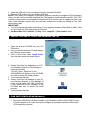
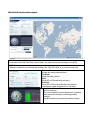
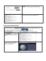
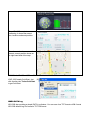
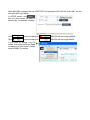
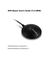
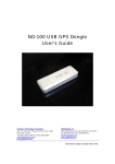
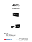
ND-100S USB GPS Dongle
User’s Guide
V1.0
Globalsat Technology Corporation
16F., No. 186, Jian-Yi Road, Chung-Ho City,
Taipei Hsien 235, Taiwan
Tel: 886-2-8226-3799/ Fax: 886-2-8226-3899
[email protected]
www.globalsat.com.tw
USGlobalSat, Inc.
1308 John Reed Court, City of Industry,
CA 91745
Tel: 626-968-4145 / Fax: 626-968-4373
[email protected]
www.usglobalsat.com
DOCUMENT REVISIONS
REV NO.
DATE
0.1
2010/3/17
0.2
2010/3/23
1.0
2010/3/24
DESCRIPTION
Initial document
Modify PC Utility descript
Official Version
BY
TWG
TWG
TWG
© 2010 Globalsat Technology Corporation/USGlobalsat, Inc. All rights reserved. The Globalsat
logo is a trademark of Globalsat Corporation. Windows is a registered trademark of Microsoft
Corporation. Acrobat is a registered trademark of Adobe Systems Incorporated. Mac is a
registered trademark of the Apple Corporation. All other trademarks or registered trademarks
are acknowledged as the exclusive property of their respective owners.
All rights reserved. No part of this manual may be reproduced, transmitted, copied, or stored in
any storage medium, for any purpose, without prior written consent from Globalsat Technology
Corporation or USGlobalsat, Inc. Globalsat/USGlobalsat hereby grants the right to download one
(1) copy of this manual onto a hard drive for personal use. This manual is copyrighted and may
contain proprietary information that is subject to change without notice.
Table of Contents
PACKAGE CONTENTS..................................................................................................................................................... 4
SYSTEM REQUIREMENTS.............................................................................................................................................. 4
WELCOME ......................................................................................................................................................................... 4
1. GETTING STARTED .................................................................................................................................................... 4
2. INSTALL THE USB PC TOOLS FOR WINDOWS LAPTOP ...................................................................................... 5
3. COM PORT VERIFICATION (Windows) ..................................................................................................................... 5
4. INITIALIZING YOUR ND-100S..................................................................................................................................... 6
5. USING ND-100S (Windows)......................................................................................................................................... 6
ND-100S AP interface Description................................................................................................................... 7
Starting using the ND-100S with AP ................................................................................................................ 8
Cold Start / Hot Start / Warm Start .................................................................................................................. 9
NMEA DATA Log.............................................................................................................................................. 9
6. UNINSTALLING THE USB DRIVER and PC Utility(Windows)................................................................................. 11
7. FAQ’s ........................................................................................................................................................................... 11
8. CONTACT INFORMATION........................................................................................................................................ 12
9. SAFETY AND LEGAL NOTICES ............................................................................................................................... 13
10. LIMITED WARRANTY .............................................................................................................................................. 13
11. ND-100S SPECIFICATIONS.................................................................................................................................... 15
12. FCC NOTICE ............................................................................................................................................................ 16
PACKAGE CONTENTS
ND-100S Main Unit
USB Cable
CD-ROM (User
Guide, Driver, etc)
Quick Start Guide
Note:
If any item is found to be damaged or missing, please contact your local retailer for assistance.
SYSTEM REQUIREMENTS
The ND-100S requires the minimum to run on a laptop:
Operating System: Windows 2000 / XP / Vista / Windows7
CPU: 500 MHz, Pentium III
System Memory (RAM): 128MB RAM
Hard Disk: 50MB free space
Display: 1024x768, "16-bit High Color" screen
WELCOME
Thank you for your purchase of the GlobalSat ND-100S USB Dongle GPS Receiver. The ND100S is a compact and portable device, which allows you to carry a GPS receiver for use on your
laptop whenever you travel. The ND-100S requires no battery or cables, only your favorite NMEA
compliant navigation software is all that’s needed to turn a laptop into a powerful navigation
system.
Works with Windows, Mac and Linux O/S notebooks and laptops. If you need navigation software,
you can check-out www.usglobalsat.com under the Navigation Software section for
recommendations.
1. GETTING STARTED
There are only a few simple steps that you need to follow before using your ND-100S:
• Install the USB driver onto your laptop using the included CD-ROM
• Plug the GPS receiver into your laptop’s USB port.
NOTE: From within your mapping or navigation software (including the supplied GPS Information
utility), you will need to manually configure the COM port that was assigned to the ND-100S GPS
receiver so that proper communication between the GPS receiver and a mapping program can
occur. Most software requires that you manually configure the COM port setting for any GPS
device being used.
IMPORTANT:
1. You must change the default rate setting of your mapping software‘s Baud Rate to 4800, if this
is not set then the GPS data cannot be received.
2. Set Baud Rate 4800, Data Bit: 8, Parity: None, Stop Bit: 1, Flow Control: None
2. INSTALL THE USB PC TOOLS FOR WINDOWS LAPTOP
1. Place the product CD-ROM into your CDROM drive.
2. Auto-run should detect the CD and bring up
the following screen below.
3. Click on the button titled “Install Driver”
from the main screen as shown above.
4. Should “Auto-Run” be disabled on your PC,
use Windows Explorer or File Manager to
locate the file titled
“PL2303_Driver_Setup.exe” in the
\WIN\USB Driver\ directory of the CD-ROM
and click to launch the install process.
5. You should see the files:
6. Should “Auto-Run” be disabled on your PC,
use Windows Explorer or File Manager to
locate the file titled “ND-100S_Setup.exe”
in the \WIN\USB Driver\ directory of the
CD-ROM and click to launch the install
process.
7. You should see the files:
3. COM PORT VERIFICATION (Windows)
1. Once your USB Driver has been installed, you will need to confirm which COM Port your
PC has assigned to it in order to properly configure any software that will be utilizing the
GPS data being received.
2. Your USB GPS MUST be plugged into your USB port at this time.
3. Using Window’s Control Panel, select System > Hardware > Device Manager
4. Then look under the heading of: PORTS (Com & LPT)
5. There should be a listing for: Prolific Serial-to-USB Com Port (COM x)
(where “x” is the number your PC has assigned the USB GPS receiver).
6. Once you have identified the COM port number, any software that you utilize must be
configured to read GPS data from this COM port.
We strongly suggest that you first test your USB GPS with the included GPS Info utility
program to confirm that the GPS receiver is functioning properly on your PC and that you have
successfully configured the right COM Port setting. Once this has been done, close the GPS
Info program and start your application for COM port configuration.
NOTE: By default, your PC will not allow you to run multiple applications from a single COM
port. It is important that you close any previously opened GPS application before switching to
another GPS application as the GPS receiver and data will not be found by the new program.
There are special utilities available to split data into multiple COM ports for use by more than
one application simultaneously. See: http://franson.com/gpsgate/
4. INITIALIZING YOUR ND-100S
Before using your ND-100S receiver for navigation (especially for the first time), the receiver must
obtain a local GPS fix (coordinates) of the current position. To do this, take your laptop (with your
USB driver and the mapping software loaded and configurable) to an open area that has a clear
view to the sky (such as a park or empty field). Start your software (or the included GPS Info utility
program) and wait for initialization of the GPS to complete. This may take a few minutes
depending on various factors such as the distance of the current coordinates from the last time the
GPS receiver was activated, GPS signal strength and surrounding terrain (tall trees and buildings
can block the satellite signals). Once the RAW GPS data is displayed onto the screen, if
applicable for your software, a fix has been initialized (blue LED on the GPS will also start to flash).
In some cases initialization can take up to several minutes depending on the conditions mentioned
above before complete GPS data will be displayed on the screen.
Coordinates with scrolling zeros mean that the port connection is complete but the satellite data is
not being received yet (possibly still initializing or in a bad area for satellite reception).
5. USING ND-100S (Windows)
After completing the application installation and ND-100S connecting with the NB properly, we will
be able to open the application on the desktop click
ND-100S AP interface Description
MENU
Executable ND-100S Cold Start / Warm Start / Hot Start and set the format type of Log File
MAP Portion
When the notebook is connected with internet, ND-100S AP’s MAP is go to show world map.
Time and Date:
Shows the current date and time
Fix Mode:
Show the state position.
DOP:
Show ND-100S positioning accuracy
Position:
Show ND-100S location latitude and longitude
coordinates, height and direction of the angle.
Satellite & Channel Status
100S is receiving..
The circle shows the current distribution of satellite;
Solid green bar indicates positioning satellite
intensity.
Red Bar shows non-positioning satellite intensity.
SETUP
Show the ND-100S Setting in NB COM PORT.
Terminal
Show the ND-100S receiving NMEA DATA.
★Note: If the notebook is not connected with internet, ND-100S AP’s MAP can not to show.
Starting using the ND-100S with AP
In the SETUP PAGE, click
,ND-100S AP will automatically set the com
port of ND-100S, Baud Rate is set 4800, click
,the icon will become
Click
, ND-100S AP will
to show ND-100S receiving NMEA
DATA.
In positioning process, ND-100S
indicates the receipt of satellite
intensity and distribution.
NO Fixed
and then click
,ND-100S begins working.
Positioning completed
When ND-100S completes
positioning, it shows the current
time, location mode and position.
When the notebook connects with
internet, current position shows on
the right hand side of the map.
Cold Start / Hot Start / Warm Start
If ND-100S needs Cold Start. Just
click function tab: Tools>Cold Start
to get Cold Start.
NMEA DATA Log
ND-100S also provides a simple DATA Log feature. You can save it as TXT format or KML format
ND-100S default Log File format is TXT File format.
While ND-100S is plugged into the USB PORT and implement ND-100S AP on the NB, we can
start ND-100S Log function.
,
In SETUP portion, click
then you can choose file folder to
save log file. For example, Desktop.
Click
, bullet will change to
. ND100S will start logging NMEA.
Click
, bullet will change to
. ND100S will stop loggin NMEA.
If you want to change Log File
format, Just click function tab Tools
to change it to KML format. (Default
setup is NMEA Txt format)
6. UNINSTALLING THE USB DRIVER and PC Utility(Windows)
To uninstall the ND-100S driver, click the Windows START button >>PROGRAMS>>PL-2303
USB-Serial Driver and select UNINSTALLER from the menu.
To uninstall the ND-100S PC Utility, click the Windows START button >>PROGRAMS>>ND-100S
and select Uninstall from the menu.
7. FAQ’s
I am not getting GPS data into my application.
1. Check your DEVICE MANAGER to confirm the COM Port number assigned to the GPS
Receiver (it will be listed under the PORTS (COM & LPT) heading as Prolific Serial-to-USB
Comm. Then be sure this is the same COM port number configured in your application.
2. Be sure your Baud rate is configured correctly at:
Baud Rate: 4800
Data bit: 8
Parity: None
Stop Bit: 1
Flow Control: None
3. Re-boot your computer and then insert the USB GPS into a USB port.
4. Configure the GPS Info utility with the correct COM Port and test your GPS receiver first
before using it in your application.
Will the ND-100S work with Street Map, Marine Chart or Aviation software?
Globalsat USB GPS receivers provide standard NMEA data for mapping software to use and
convert to coordinates. Data from the ND-100S should work well with most any NMEA compliant
software on the market today.
How accurate is the GPS?
The ND-100S is WAAS/EGNOS capable. Units sold in North America through authorized resellers
are WAAS/EGNOS enabled unless otherwise stated. Accuracy can be up 2.2 Meters CEP without
DGPS
What is ideal GPS environment?
The GPS requires an open, clear view of the sky. Buildings, covered parking areas, tunnels and
dense foliage can cause the GPS receiver to be unable to get a location fix.
If you are parked in a covered parking lot or near a tall building, it is recommended that you drive
away until you have a clear view of the sky before using the ND-100S. You may need to give the
GPS a few minutes to find or get a fix its location.
How do I know if the GPS is ON?
Your USB GPS must be plugged into your laptop’s USB port to get power. If your PC is on and
the COM port was configured properly, the GPS receiver is on and receiving the streaming GPS
data. This can be verified by opening your mapping software program. In addition, the Globalsat
USB GPS has a built-in LED status indicator that shows the following:
LED OFF: GPS receiver is off (no power).
LED ON (solid): No fix, searching for GPS signals.
LED FLASHING: Position fix established and GPS signals are being received.
Why does the GPS not work near buildings and other tall objects?
The GPS uses satellites in the space to find out where it is. Therefore it needs a clear view of the
sky. Tall buildings and other objects that block the receiver’s view to the sky make it infeasible to
determine your location. Sometimes the satellites are not overhead but near the horizon. In these
cases the GPS must have a clear view of the horizon.
8. CONTACT INFORMATION
Globalsat Technology Corporation (Taiwan)
www.globalsat.com.tw
[email protected] (pre-sales GPS product questions only)
USGlobalsat, Inc.
www.usglobalsat.com
[email protected] (pre-sales GPS product questions only)
Technical Support (North America)
See our DOWNLOADS and FAQ section on our web-site for GPS driver updates.
http://www.usglobalsat.com
Pre-registration is required before receiving any type of technical support and using our online
“Support Ticket” from USGlobalsat’s web-site will expedite in getting your issues handles in a
secure and prompt manner. If products were purchased from a dealer other that USGlobalSat,
please create your account and register your product at :
www.usglobalsat.com/support/custadminlogin.asp
9. SAFETY AND LEGAL NOTICES
Please read this section carefully before using the GPS receiver
Globalsat Technology Corporation / USGlobalsat, Inc. will not accept any responsibility
whatsoever for accidents resulting from failure to observe common sense precautions.
Your personal judgment, traffic regulations, and common sense must always take
precedence over any directions produced by GPS receiver or the mapping software
WARNING: Make sure that the GPS receiver is secure and does not interfere with driving
visibility and safety.
It is your responsibility as the vehicle operator to securely place the GPS unit and antenna so that
they will not interfere with driving and prevent operations of any safety device (such as the Airbag)
in your vehicle. Do not mount the devices in a place where the driver or passengers may receive
injury during vehicle operation or collision. For your safety, take care to route all cables away from
shifters, pedals, accessory controls and mechanisms.
WARNING: Drive safely and use common sense.
It is your responsibility as the vehicle operator to drive safely, observe all traffic rules and above all
use your own personal judgment while driving. If you feel that a route suggested by the navigation
software instructs you to perform an unsafe or illegal maneuver, places you in an unsafe situation,
or routes you into an area which you consider unsafe, do not follow the instructions.
WARNING: Keep your eyes on the road.
It is your responsibility as the vehicle operator to keep your eyes on the road and be an alert driver
at all times, especially when the vehicle is moving. The vehicle’s operator should not be distracted
by the navigation equipment or software. Should there be a distraction with the ability to drive
responsibly, please turn off the device. Should you want to look at the display for a prolonged time,
park the car safely, while following all traffic regulations before looking at the display.
WARNING: To reduce the risk of fire or shock hazard, do not expose this product to rain or
moisture. Do not remove covers or open housings, there are no user serviceable parts
inside. Refer servicing to qualified personnel only.
10. LIMITED WARRANTY
Globalsat/USGlobalsat warrants product hardware against manufacturing defects in material and
workmanship under normal use for a period of one (1) year from the original date of purchase
(unless the product states otherwise), and only when purchased from a recognized “authorized
dealer”. Products purchased from any unauthorized source, such as unauthorized e-Bay resellers,
will not qualify for free warranty service/support and may require the end-user to pre-pay fees
associated with, but not limited to the support, repair, replacement and shipping of the product to
and from the service center.
Except as provided herein, Globalsat/USGlobalsat makes no express warranties’, including but
not limited to any warranties of merchantability or fitness for particular use, or non-infringement.
You acknowledge that your use of the product or service is at your sole risk and you agree that the
information provided are without warranty of any kind by Globalsat/USGlobalsat.
Under no circumstances, including negligence, will Globalsat/USGlobalsat or any of its affiliates,
directors, officers or employees, or any third party be liable for any direct, indirect, incidental,
special or consequential damages that results from your use, or your inability to use, or the
performance of the product(s) with respect to any liability, loss, or arising out of any breach of this
warranty, including, but not limited to any damages resulting from inconvenience, loss of time, data,
property, revenue, or profit or any indirect, special incidental or consequential damages. You
acknowledge that this limitation applies to all content information or other services available from
Globalsat/USGlobalsat, and whether or not Globalsat/USGlobalsat has notice of the possibility of
such damages, and whether or not to circumstances giving rise to such damages may have been
within the control of Globalsat/USGlobalsat.
Some states do not allow the exclusion of certain warranties, so some of the above exclusions
may not apply to you. In those states, liability is limited to the fullest extent allowed by law By
using the product(s), you agree to indemnify Globalsat/USGlobalsat and its parents, subsidiaries,
affiliates, officers and employees and hold them harmless from any and all claims and expenses,
including reasonable attorney’s fees, asserted third party due to, or arising out of your use of the
service and the site.
In the event of a product defect during the first 30-days of the warranty period, return product and
the sales receipt as proof of purchase date to place of original purchase. Defect discovered after
30-days from date of purchase, you must contact Globalsat/USGlobalsat’s Technical support for a
Return Merchandise Authorization (RMA) number for return to manufacturer.
Globalsat/USGlobalsat will, at its option, unless otherwise provided by law:
a.) Correct the defect by product repair without charge for parts and labor;
b.) Replace the product with one of the same or similar design; or
Refund the purchase price. All replaced parts and products, and products on which a refund is
made, become the property of Globalsat/USGlobalsat. New or reconditioned parts may be used
in the performance of warranty service. Repaired or replaced parts and products are warranted
for the remainder of the original warranty period. You will be charged for repair or replacement of
the product made after the expiration of the warranty period.
This warranty does not cover:
a.) Damage or failure caused by or attributable to acts of God, abuse, accident, misuse,
improper or abnormal usage, failure to follow the instructions, improper installation or
maintenance, alteration, lighting or other incidence of excess voltage or current;
b.) Any repairs other than those provided by Globalsat/USGlobalsat;
c.) Consumables such as fuses or batteries;
d.) Cosmetic damage;
e.) Transportation, shipping or insurance costs;
f.) Costs of product removal, installation, set-up service adjustment or reinstallation.
This warranty gives you specific legal rights, and you may also have other rights, which may vary
from state to state.
Additional products bundled in this package not manufactured by Globalsat/USGlobalsat will hold
separate warranties as expressed by the individual manufacturer of that product(s). Product
specifications, functions and features are subject to change without notice.
11. ND-100S SPECIFICATIONS
Electrical Characteristics
GPS Chipset
Frequency
C/A Code
Channels
Sensitivity
Accuracy
Position Horizontal
Velocity
Time
Datum
Datum
Acquisition Rate
Hot start
Warm start
Cold start
Reacquisition
Protocol
GPS Protocol
GPS Output Data
GPS transfer rate
SiRF Star III e/LP
L1, 1575.42 MHZ
1.023 MHz chip rate
20 all-in-view tracking
-159 dBm
5m 2D RMS WAAS enabled
10m 2D RMS WAAS disabled
0.1m/sec 95% (SA off),
1 micro-second synchronized to GPS time
WGS-84
1 sec., average (with ephemeris and almanac valid)
38 sec., average (with almanac but not ephemeris)
42 sec., average (neither almanac nor ephemeris)
0.1 sec. average (interruption recovery time)
Default: NMEA 0183 (Secondary: SiRF binary)
NMEA 0183 MEA0183 V2.2 protocol, and supports
command: GGA, GSA, GSV, RMC, VTG, GLL v2.2
Software command setting (Default : 4800,n,8,1 for
NMEA )
Dynamic Condition
Acceleration Limit
Less than 4g
Altitude Limit
18,000 meters (60,000 feet) max.
Velocity Limit
515 meters/sec. (1,000 knots) max.
Jerk Limit
20 m/sec**3
Temperature
Operating
-20°~ 70°C
Storage
-20°~ 80°C
Humidity
Up to 95% non-condensing
Power
Voltage
4.5 ~ 5.5V DC Input
Current
50mA typical
Physical Characteristics
Dimension
2.6”L x 0.9”W x 0.4”H (65.5L x 23W x 11H mm)
Unit Weight
0.04 lbs (20g)
Certifications
FCC
USA (Covers requirements for CANADA ICES-003)
CE
Europe
Due to continuous product improvements, all specifications are subject to change without notice.
12. FCC NOTICE
This equipment has been tested and found to comply with the limits for a Class B digital device,
pursuant to Part 15 of the FCC Rules. These limits are designed to provide reasonable protection
against harmful interference in a residential installation. This equipment generates, uses and can
radiate radio frequency energy and, if not installed and used in accordance with the instructions,
may cause harmful interference to radio communications. However, there is no guarantee that
interference will not occur in a particular installation. If this equipment does cause harmful
interference to radio or television reception, which can be determined by turning the equipment off
and on, the user is encouraged to try to correct the interference by one of the following measures:
•
•
•
•
Reorient or relocate the receiving antenna.
Increase the separation between the equipment and receiver.
Connect the equipment into an outlet on a circuit different from that to which the receiver is
connected.
Consult the dealer or an experienced radio/TV technician for help.
FCC Caution: Any changes or modifications not expressly approved by the party responsible for
compliance could void the user's authority to operate this equipment.
This device complies with Part 15 of the FCC Rules. Operation is subject to the following two
conditions: (1) This device may not cause harmful interference, and (2) this device must accept
any interference received, including interference that may cause undesired operation.
IMPORTANT NOTE:
Radiation Exposure Statement:
This equipment complies with FCC radiation exposure limits set forth for an uncontrolled
environment. End users must follow the specific operating instructions for satisfying RF exposure
compliance. To maintain compliance with FCC RF exposure compliance requirements, please
follow operation instruction as documented in this manual.
This transmitter must not be co-located or operating in conjunction with any other antenna or
transmitter.
The availability of some specific channels and/or operational frequency bands are country
dependent and are firmware programmed at the factory to match the intended destination. The
firmware setting is not accessible by the end user.