1
INTREPID User Manual
Library | Help | Top
Available map attribute values (R22)
1
| Back |
Available map attribute values (R22)
Top
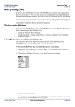
If you are using the Map Composition tool interactively, you can usually specify
attribute values by choosing them from a list or palette or by typing them in. If you
are preparing your map by programming in MAPCOMP, then you also need to type
the required values into your MAPCOMP file.
See Specifying map attribute values (T45e) for instructions on choosing attribute
values from lists or palettes.
This appendix describes the available attribute values that you can type in when
using the Map Composition tool interactively, and when programming in MAPCOMP
language.
Symbol shape
If you are specifying a symbol by name, either in MAPCOMP language or in the
interactive Map Composition tool, you can use any of the symbol names in the
following sections.
In MAPCOMP the <symbol> data type must take one of the values described here.
Standard symbol shapes hierarchy
The standard INTREPID Map symbol set has a ranking order. Using a legend you
can represent ranges of values with different symbols. We have arranged the list in
order, from the symbol that normally corresponds to the lowest value through to the
symbol that corresponds to the highest value.
Square, Plus, Asterisk, Circle, Triangle, Cross, SquarePlus,
SquareCross, Dot, SolidSquare, SolidCircle, SolidTriangle,
SolidSquarePlus, SolidSquareCross
This hierarchy is defined in mapcomp.cfg. You can edit it if required. See Map
composition configuration files (R21) for further information.
Library | Help | Top
© 2012 Intrepid Geophysics
| Back |
INTREPID User Manual
Library | Help | Top
Available map attribute values (R22)
2
| Back |
Special purpose symbol shapes
The following symbol shapes are not part of the standard symbol hierarchy. We have
designed them with special purposes in mind, as described here.
You can directly use the Naudy model output fields dip, length, width rather
than the scaled versions MC_slope, MC_length, MC_width.
If you are composing map of a Naudy model point dataset using rectangle and/or
dip symbols, we recommend the following field-to-attribute assignments.
MAPCOMP attribute of
rectangle or dip
symbol
Naudy dataset field
to assign to
rectangle symbol
Naudy dataset field to assign to dip
symbol
colour
depth
If used with rectangle symbol: black
If used alone: depth field
angle
strike
strike
size
length
length
thickness
width
dip
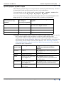
rectangle The rectangle symbol consists of a filled rectangle shape. You can specify
the rectangle symbol's other attributes as shown in the following table.
A typical use of the rectangle symbol is to show inferred geological structures
calculated by the Naudy Automatic Model tool. The table includes suggestions for
representing Naudy model solutions point datasets. See "Structure of Naudy
model point datasets" in Naudy Automatic Model interpretation (T43) and other
sections for more information.
Library | Help | Top
Attribute in
MAPCOMP
Rectangle attribute
Suggested value or Naudy model
solutions point dataset field for
display
colour
colour
MC_slope (dip of inferred geological
structure)
angle
angle from North
0
size
North–South dimension
(for angle = 0)
MC_length (length of inferred
geological structure perpendicular to
line direction)
thickness
East–West dimension
(for angle = 0)
MC_width (width of inferred geological
structure parallel to line direction)
–
Thickness of lines fixed
at 0.2 mm
–
© 2012 Intrepid Geophysics
| Back |
INTREPID User Manual
Library | Help | Top
Available map attribute values (R22)
3
| Back |
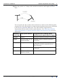
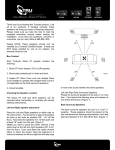
dip The dip symbol is a T shape with variable orientation, and lengths of its two
lines.
You can specify the dip symbol's other attributes as shown in the following table.
A typical use of the dip symbol is to show inferred geological structures calculated
by the Naudy Automatic Model tool. The table includes suggestions for
representing Naudy model solutions point datasets. See "Structure of Naudy
model point datasets" in Naudy Automatic Model interpretation (T43) for more
information.
Dip symbol attribute
Suggested value or Naudy model
solutions point dataset field for display
colour
colour
Z (depth of inferred geological structure)
angle
rotation angle (0 =
(North–South))
strike (strike of inferred geological
structure)
size
length of crossbar
MC_length (length of inferred
geological structure perpendicular to
line direction)
thickness
length of shaft
MC_slope (dip of inferred geological
structure)
–
Thickness of lines
fixed at 0.2 mm
–
T
Library | Help | Top
Attribute in
MAPCOMP
© 2012 Intrepid Geophysics
| Back |
INTREPID User Manual
Library | Help | Top
Available map attribute values (R22)
4
| Back |
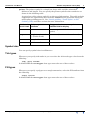
pointer The pointer symbol is a simple bar shape with variable orientation,
thickness and length. You can specify the pointer symbol's other attributes as
shown in the following table.
A typical use of the pointer symbol is to plot trend information. The table includes
suggestions for representing data from the trend dataset generated during the
trend spline gridding process. See "Initial gridding—Trend Spline" in Old
Gridding (T22) and other sections for more information.
Attribute in
MAPCOMP
Pointer symbol
attribute
Suggested value or trend point
dataset field for display
colour
colour
TRENDZ (gridded Z field value for data
point)
angle
angle 0 = orientation
| (North–South)
BEARING (direction of detected trend)
size
length of bar
2
thickness
thickness of bar
0
Symbol size
You can specify symbol sizes in millimetres.
Tick types
Whenever you specify tick marks in you can select the tick mark type value from the
following:
tick, grid, border
In MAPCOMP the <ticktype> data type must take one of these values.
Fill types
Whenever you specify a polygon or rectangle annotation, select the Fill attribute from
the following:
solid, hollow
In MAPCOMP the <filltype> data type must take one of these values.
Library | Help | Top
© 2012 Intrepid Geophysics
| Back |
INTREPID User Manual
Library | Help | Top
Available map attribute values (R22)
5
| Back |
Text justification
Whenever you specify text, select its justification from the following:
lt, ct, rt
lc, cc, rc
lb, cb, rb
where l, c, r stand for left, centre, right
and t, c, b stand for top, centre, bottom
The default value is normally lb
This data type enables you to specify text to be located in one of nine positions in a
text object.
In MAPCOMP the <justification> data type must take one of these values. You
can also displace text from the left bottom of the object with the XY = { <number>
<number> ... } statement.
Typeface ('font')
Note: With regard to text, the term 'font', when correctly used, refers to a
combination of a typeface (character shape), a size and a style (e.g., normal, bold,
italic). However, a common convention is to use the term 'font' to refer to typeface.
The Map Composition tool uses this convention—the term 'font' is used to label
buttons and text boxes that control typeface.
INTREPID has a standard set of typefaces including a default internal typeface (font
0) and a number of typefaces defined by typeface files in the directory install_path
/font (where install_path is the location of your INTREPID installation). The
names of the typefaces files are font2.fnt, ..., font20.fnt.
In MAPCOMP your typeface selection is represented by the <typeface> data type
which is a whole number. The <typeface> value for a typeface corresponds to the
number in its file name. For example if you specify typeface 18, INTREPID will use
font18.fnt as the typeface definition. INTREPID does not necessarily have all
typeface numbers between 1 and 20. Use the Typeface dialog box interactively or
check the directory install_path /font for the existence of the corresponding file if
you are uncertain.
If you specify font 0 or select Default from the Typeface dialog box. INTREPID will
use its internal default typeface, which does not have a .fnt file.
Font size
You can specify font size in millimetres. 1 millimetre equals approximately 3 points
(more exactly 2.83 points).
Library | Help | Top
© 2012 Intrepid Geophysics
| Back |
INTREPID User Manual
Library | Help | Top
Available map attribute values (R22)
6
| Back |
Line thickness and font weight
Whenever you specify a line thickness or the weight of a font you can select it from
the following thickness levels.
0, 1, 2, 3, ...
0 corresponds to the thinnest line that the output device can produce. Numbers > 0
correspond to the thickness in millimetres.
In INTREPID <thickness> must take one of these values.
Line styles
Whenever you specify a line style you can select it from the following:
solid, dash, dashdot
In a line dataset path plot you can also specify the bipole style. See "(Bipole style)"
in Including datasets in a map composition (T45b) or details.
In MAPCOMP the <style> data type must take one of these values.
Colour Specifications
If you are specifying a colour by name you can use any of the following colour names:
•
Colours from the X.11 named colours database. This database includes the colour
names black white red green blue yellow magenta cyan, and maps
names to specific RGB mixes (e.g., Cyan is 000r255g255b, PapayaWhip is
255r239g213b). The file rgb.txt in the install_path /config directory
(where install_path is the location of your INTREPID installation) contains a
complete list of these colours and their corresponding RGB values.
•
Explicit RGB values using decimal numbers in the range 0..255 and the format
999r999g999b (e.g., 255r125g000b).
•
The names image1 .. image256 (e.g., image33). These names specify colours
from the currently loaded lookup table (.lut file). See "Lookup table (.lut) files"
in Map composition configuration files (R21) for a full description of lookup table
specification. If you are using a variety of lookup tables or have both grey scale
and pseudocolour elements in your map data, then we recommend that you avoid
using these names in Map Composition interactive mode.
•
The names foreground and background. These are INTREPID system colour
identifiers whose precise definition depend on the context. For the purposes of
Map Composition you can take foreground to be black and background to be
white.
In MAPCOMP the <colour> data type must take one of the values described above.
Library | Help | Top
© 2012 Intrepid Geophysics
| Back |
INTREPID User Manual
Library | Help | Top
Available map attribute values (R22)
7
| Back |
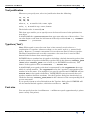
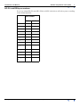
HP–GL and DGN pen numbers
If you are using HP–GL (not HP–GL/2) or DGN, the driver will select pens according
to the following table:
Pen number
Library | Help | Top
DGN
HP–GL
Black
0
1
White
1
2
Red
2
3
Green
3
4
Blue
4
5
Legend1
5
6
Legend2
6
7
...
...
...
Legend1
2
16
17
Image1
17
18
Image2
18
19
...
...
...
Image25
5
271
272
© 2012 Intrepid Geophysics
| Back |