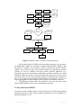
1
SDSM 4.2 — A decision support tool for the
assessment of regional climate change impacts
User Manual
Robert L. Wilby1,2 and Christian W. Dawson3
August 2007
1
2
Department of Geography, Lancaster University, UK
Science Department, Environment Agency of England and Wales, UK
3
Department of Computer Science, Loughborough University, UK
Preface
General Circulation Models (GCMs) suggest that rising concentrations of greenhouse
gases will have significant implications for climate at global and regional scales. Less
certain is the extent to which meteorological processes at individual sites will be
affected. So–called “downscaling” techniques are used to bridge the spatial and
temporal resolution gaps between what climate modellers are currently able to provide
and what impact assessors require.
This manual describes a decision support tool for assessing local climate
change impacts using a robust statistical downscaling technique. SDSM 4.2
(Statistical DownScaling Model) facilitates the rapid development of multiple, low–
cost, single–site scenarios of daily surface weather variables under present and future
climate forcing. Additionally, the software performs ancillary tasks of data quality
control and transformation, predictor variable pre–screening, automatic model
calibration, basic diagnostic testing, statistical analyses and graphing of climate data.
This manual also describes the UKSDSM archive, a set of daily predictor
variables prepared for model calibration and downscaling at sites across the UK. The
archive contains variables describing atmospheric circulation, thickness, stability and
moisture content at several levels in the atmosphere, under climate conditions
observed between 1961 and 1990. Equivalent predictor variables are provided for four
GCM experiments of transient climate change between 1961 and 2099. Users seeking
to apply SDSM to regions outside the UK may obtain predictor variables online by
visiting: http://www.cics.uvic.ca/scenarios/index.cgi?Scenarios
Application of SDSM is illustrated with respect to the downscaling of daily
maximum temperature and precipitation scenarios fat a hypothetical location
(Blogsville) under present (1961–90) and future (2070–99) climate forcing.
© Wilby & Dawson, 2007
Page 2 of 94
Acknowledgements
SDSM Version 4.2 was supported by the Environment Agency of England and Wales
as part of the Thames Estuary 2100 project.
SDSM Version 3.1 was supported by the Environment Agency of England and Wales
as part of the Climate Impacts and Adaptation Research Programme. The UKSDSM
data archive was updated by Ian Harris (Climate Research Unit) and now includes
data kindly supplied by the UK Hadley Centre, CSIRO Atmospheric Research, and
the Canadian Centre for Climate Modelling and Analysis.
SDSM Version 2.2 was sponsored by the Environment Agency through the National
Centre for Risk Analysis and Options Appraisal.
SDSM Version 2.1 was supported by the Canadian Climate Impacts Scenarios (CCIS)
Group though the Climate Change Action Fund. Assistance in kind was provided by
A Consortium for the Application of Climate Impact Assessments (ACACIA) at the
National Centre for Atmospheric Research (NCAR). NCAR is sponsored by the U.S.
National Science Foundation.
NCEP Re–analysis data were provided by the NOAA-CIRES Climate Diagnostics
Center, Boulder, Colorado, USA, from their Web site at http://www.cdc.noaa.gov/
The Climate Impacts LINK Project is funded by the UK Department of the
Environment, Transport and the Regions (Contract Reference EPG 1/1/124).
© Wilby & Dawson, 2007
Page 3 of 94
CONTENTS
Page
2
3
i Preface
ii Acknowledgements
0 TECHNICAL INFORMATION
6
1 INTRODUCTION
7
1.1
1.2
1.3
Downscaling techniques
1.1.1 Dynamical
1.1.2 Weather typing
1.1.3 Stochastic weather generators
1.1.4 Transfer functions
Relative skill of statistical and dynamical downscaling techniques
Manual outline
2 OVERVIEW OF SDSM STRUCTURE AND UKSDSM ARCHIVE
2.1
2.2
2.3
2.4
2.5
Key functions of SDSM
2.1.1 Quality control and data transformation
2.1.2 Screening of downscaling predictor variables
2.1.3 Model calibration
2.1.4 Weather generator
2.1.5 Data analysis
2.1.6 Graphical analysis
2.1.7 Scenario generation
UKSDSM data archive
UKSDSM predictors
SDSM file protocols
Obtaining SDSM predictors online
3 GETTING STARTED
3.1
3.2
Settings
Advanced settings
4 QUALITY CONTROL AND DATA TRANSFORMATION
4.1
4.2
Quality control
Data transformation
5 SCREENING OF DOWNSCALING PREDICTOR VARIABLES
5.1
5.2
5.3
5.4
Setup
Temporal variations in predictor strength
Correlation matrix
Scatterplot
6 MODEL CALIBRATION
© Wilby & Dawson, 2007
8
8
9
9
9
10
11
12
13
14
14
14
14
15
15
15
15
16
17
19
20
21
22
24
24
25
27
27
28
29
30
32
Page 4 of 94
File handling
Model type
Blogsville example
The *.PAR file
32
33
34
35
7 WEATHER GENERATOR
37
File handling
Ensemble size
Blogsville example
37
38
39
6.1
6.2
6.3
6.4
7.1
7.2
7.3
8 ANALYSIS OF OBSERVED AND DOWNSCALED DATA
8.1
8.2
8.3
Overview
Delta Statistics
The Statistics
9 FREQUENCY ANALYSIS
9.1
9.2
9.3
Setup
Diagnostics and plots
Extreme value analysis
10 SCENARIO GENERATION
41
41
44
45
47
47
48
50
55
Check settings
Setup
Blogsville example (temperature)
Blogsville example (precipitation)
55
56
57
60
11 GRAPHING MONTHLY STATISTICS
65
10.1
10.2
10.3
10.4
11.1 Line chart
11.2 Bar chart
11.3 Customizing charts
12 TIME SERIES ANALYSIS
12.1 Time series chart
12.2 Adjusting chart appearance
65
66
67
69
69
72
13 FINAL CAUTIONARY REMARKS
75
BIBLIOGRAPHY
76
APPENDIX 1: ENHANCEMENTS SINCE SDSM VERSION 3.1
APPENDIX 2: FREQUENTLY ASKED QUESTIONS
84
86
GLOSSARY
90
© Wilby & Dawson, 2007
Page 5 of 94
0 TECHNICAL INFORMATION
SDSM version 4.2 runs on PC-based systems and has been tested on Windows
98/NT/2000/XP. Note, on older machines, some statistical analyses may take longer
to perform and/or may exhaust available memory when large data sets are processed.
© Wilby & Dawson, 2007
Page 6 of 94
1. INTRODUCTION
Even if global climate models in the future are run at high resolution there will
remain the need to ‘downscale’ the results from such models to individual sites or
localities for impact studies (DOE, 1996; p34).
General Circulation Models (GCMs) indicate that rising concentrations of greenhouse
gases will have significant implications for climate at global and regional scales.
Unfortunately, GCMs are restricted in their usefulness for local impact studies by
their coarse spatial resolution (typically of the order 50,000 km2) and inability to
resolve important sub–grid scale features such as clouds and topography.
As a consequence, two sets of techniques have emerged as a means of deriving
local–scale surface weather from regional–scale atmospheric predictor variables
(Figure 1.1). Firstly, statistical downscaling is analogous to the “model output
statistics” (MOS) and “perfect prog” approaches used for short–range numerical
weather prediction. Secondly, Regional Climate Models (RCMs) simulate sub–GCM
grid scale climate features dynamically using time–varying atmospheric conditions
supplied by a GCM bounding a specified domain. Both approaches will continue to
play a significant role in the assessment of potential climate change impacts arising
from future increases in greenhouse–gas concentrations.
Climate Model
Grid Scale
RCM
Downscaling
Aggregation
GCM
Precipitation
SDS
Topography
Vegetation
Soils
Land
Figure 1.1 A schematic illustrating the general approach to downscaling.
Statistical downscaling methodologies have several practical advantages over
dynamical downscaling approaches. In situations where low–cost, rapid assessments
of localised climate change impacts are required, statistical downscaling (currently)
represents the more promising option. In this manual we describe a software package,
and accompanying statistical downscaling methodology, that enables the construction
© Wilby & Dawson, 2007
Page 7 of 94
of climate change scenarios for individual sites at daily time–scales, using grid
resolution GCM output. The software is named SDSM (Statistical DownScaling
Model) and is coded in Visual Basic 6.0.
As far as the authors are aware, SDSM was the first tool of its type freely
offered to the broader climate change impacts community. Most statistical
downscaling models are generally restricted in their use to specialist researchers
and/or research establishments. Other software, although more accessible, produces
relatively coarse regional scenarios of climate change (both spatially and temporally).
For example, SCENGEN blends and re–scales user–defined combinations of GCM
experiments, and then interpolates monthly climate change scenarios onto a 5º latitude
× 5º longitude global grid. “Weather generators” — such as WGEN, LARS–WG or
CLIGEN (see bibliography) — are widely used in the hydrological and agricultural
research communities, but do not directly employ GCM output in the scenario
construction processes.
Following a brief overview of downscaling techniques, we describe the
structure and operation of SDSM with respect to seven tasks: 1) quality control and
data transformation; 2) screening of potential downscaling predictor variables; 3)
model calibration; 4) generation of ensembles of present weather data using observed
predictor variables; 5) statistical analysis of observed data and climate change
scenarios; 6) graphing model output; 7) generation of ensembles of future weather
data using GCM–derived predictor variables. The key functions of SDSM will be
illustrated using observed and climate model data for a hypothetical station
(Blogsville), comparing downscaled daily precipitation and temperature series for
1961-1990 with 2070–2099.
1.1 Downscaling techniques
The general theory, limitations and practice of downscaling have been discussed in
detail elsewhere (see bibliography). Reviews typically group downscaling
methodologies into four main types: a) dynamical climate modelling, b) synoptic
weather typing, c) stochastic weather generation, or d) transfer-function approaches.
Each family of techniques is briefly described below.
1.1.1 Dynamical
Dynamical downscaling involves the nesting of a higher resolution Regional Climate
Model (RCM) within a coarser resolution GCM. The RCM uses the GCM to define
time–varying atmospheric boundary conditions around a finite domain, within which
the physical dynamics of the atmosphere are modelled using horizontal grid spacings
of 20–50 km. The main limitation of RCMs is that they are as computationally
demanding as GCMs (placing constraints on the feasible domain size, number of
experiments and duration of simulations). The scenarios produced by RCMs are also
sensitive to the choice of boundary conditions (such as soil moisture) used to initiate
experiments. The main advantage of RCMs is that they can resolve smaller–scale
atmospheric features such as orographic precipitation or low–level jets better than the
host GCM. Furthermore, RCMs can be used to explore the relative significance of
different external forcings such as terrestrial–ecosystem or atmospheric chemistry
changes.
© Wilby & Dawson, 2007
Page 8 of 94
1.1.2 Weather typing
Weather typing approaches involve grouping local, meteorological data in relation to
prevailing patterns of atmospheric circulation. Climate change scenarios are
constructed, either by re–sampling from the observed data distributions (conditional
on the circulation patterns produced by a GCM), or by generating synthetic sequences
of weather patterns and then re–sampling from observed data. Weather pattern
downscaling is founded on sensible linkages between climate on the large scale and
weather at the local scale. The technique is also valid for a wide variety of
environmental variables as well as multi–site applications. However, weather typing
schemes ca be parochial, a poor basis for downscaling rare events, and entirely
dependent on stationary circulation–to–surface climate relationships. Potentially, the
most serious limitation is that precipitation changes produced by changes in the
frequency of weather patterns are seldom consistent with the changes produced by the
host GCM (unless additional predictors such as atmospheric humidity are employed).
1.1.3 Stochastic weather generators
Stochastic downscaling approaches typically involve modifying the parameters of
conventional weather generators such as WGEN, LARS–WG or EARWIG. The
WGEN model simulates precipitation occurrence using two–state, first order Markov
chains: precipitation amounts on wet days using a gamma distribution; temperature
and radiation components using first–order trivariate autoregression that is conditional
on precipitation occurrence. Climate change scenarios are generated stochastically
using revised parameter sets scaled in line with the outputs from a host GCM. The
main advantage of the technique is that it can exactly reproduce many observed
climate statistics and has been widely used, particularly for agricultural impact
assessment. Furthermore, stochastic weather generators enable the efficient
production of large ensembles of scenarios for risk analysis. The key disadvantages
relate to the low skill at reproducing inter-annual to decadal climate variability, and to
the unanticipated effects that changes to precipitation occurrence may have on
secondary variables such as temperature.
1.1.4 Transfer functions
Transfer-function downscaling methods rely on empirical relationships between local
scale predictands and regional scale predictor(s). Individual downscaling schemes
differ according to the choice of mathematical transfer function, predictor variables or
statistical fitting procedure. To date, linear and non–linear regression, artificial neural
networks, canonical correlation and principal components analyses have all been used
to derive predictor–predictand relationships. The main strength of transfer function
downscaling is the relative ease of application, coupled with their use of observable
trans–scale relationships. The main weakness is that the models often explain only a
fraction of the observed climate variability (especially in precipitation series). In
common with weather typing methods, transfer methods also assume validity of the
model parameters under future climate conditions, and the downscaling is highly
sensitive to the choice of predictor variables and statistical form (see below).
Furthermore, downscaling future extreme events using regression methods is
problematic since these phenomena, by definition, tend to lie at the limits or beyond
the range of the calibration data set.
© Wilby & Dawson, 2007
Page 9 of 94
1.2 Relative skill of statistical and dynamical downscaling
The wide range of downscaling techniques (both dynamical and statistical) has
prompted a growing number of model comparisons using generic data sets and
diagnostics. Until recently, these studies were restricted to statistical–versus–
statistical or dynamical–versus–dynamical model comparisons. However, some
studies are now undertaking statistical–versus–dynamical model comparisons and
Table 1.1 summarises the relative strengths and weaknesses that have emerged.
Strengths
Weakness
Statistical downscaling
Dynamical downscaling
• Station–scale climate information from
GCM–scale output
• 10–50 km resolution climate
information from GCM–scale output
• Cheap, computationally undemanding
and readily transferable
• Respond in physically consistent ways
to different external forcings
• Ensembles of climate scenarios permit
risk/ uncertainty analyses
• Resolve atmospheric processes such as
orographic precipitation
• Applicable to ‘exotic’ predictands such
as air quality and wave heights
• Consistency with GCM
• Dependent on the realism of GCM
boundary forcing
• Dependent on the realism of GCM
boundary forcing
• Choice of domain size and location
affects results
• Choice of domain size and location
affects results
• Requires high quality data for model
calibration
• Requires significant computing
resources
• Predictor–predictand relationships are
often non–stationary
• Ensembles of climate scenarios seldom
produced
• Choice of predictor variables affects
results
• Initial boundary conditions affect
results
• Choice of empirical transfer scheme
affects results
• Choice of cloud/ convection scheme
affects (precipitation) results
• Low–frequency climate variability
problematic
• Not readily transferred to new regions
or domains
• Always applied off-line, therefore,
results do not feedback into the host
GCM
• Typically applied off-line, therefore
results do not always feedback into the
host GCM
Table 1.1 Main strengths and weakness of statistical and dynamical downscaling.
The consensus of model inter–comparison studies is that dynamical and
statistical methods have comparable skill at estimating surface weather variables
under present climate conditions. However, because of recognised inter–variable
biases in host GCMs, assessing the realism of future climate change scenarios
produced by statistical downscaling methods is problematic. This is because
uncertainties exist in both GCM and downscaled climate scenarios. For example,
precipitation changes projected by the U.K. Met Office’s coupled ocean–atmosphere
model HadCM2, were found to be over–sensitive to future changes in atmospheric
humidity. Overall, the greatest obstacle to the successful implementation of both
statistical and dynamical downscaling is the realism of the GCM output used to drive
the schemes.
© Wilby & Dawson, 2007
Page 10 of 94
However, because of the parsimony and “low–tech” advantages of statistical
downscaling over dynamical downscaling (Table 1.1), a hybrid conditional weather
generator method was chosen as the basis of the decision support tool, SDSM.
1.3 Manual outline
The rest of this manual is organised in seven main parts:
Section 2 provides a brief overview of the key operations of SDSM. For a
complete description of the model specification, interested readers should refer to the
articles listed in the Bibliography (see below). Descriptions of the UKSDSM and
Canadian Climate Impacts Scenarios (CCIS) data archives and file nomenclature are
also provided in Section 2.
Sections 3 to 12 provide guidance on the practical implementation of the key
functions in SDSM for downscaling regional climate change scenarios. Application of
SDSM is illustrated using a hypothetical case study for Blogsville.
Section 13 provides a few cautionary remarks concerning the limitations of
SDSM and appropriate usage. Users are strongly recommended to consider the issues
raised here, before developing local scenarios using SDSM.
Next, a comprehensive Bibliography is supplied. This provides a general
overview of downscaling as well as more detailed discussions of the technical basis of
SDSM, example applications and comparisons with other downscaling methods.
Enhancements to SDSM since version 3.1 are listed in Appendix 1.
A trouble–shooting guide and outline of the most common pitfalls is provided
in the form of a Frequently Asked Questions (FAQs) section in Appendix 2.
Finally, definitions of commonly used technical terms related to statistical
downscaling are provided in a Glossary.
© Wilby & Dawson, 2007
Page 11 of 94
2 OVERVIEW OF SDSM STRUCTURE AND UKSDSM ARCHIVE
Downscaling is justified whenever GCM (or RCM) simulations of variable(s) used for
impacts modelling are unrealistic at the temporal and spatial scales of interest, either
because the impact scales are below the climate model’s resolution, or because of
model deficiencies. Downscaling may also be used to generate scenarios for exotic
variables (such as urban heat island intensity) that can not be obtained directly from
GCMs and RCMs. However, the host GCM must have demonstrable skill for large–
scale variables that are strongly correlated with local processes. In practice, the choice
of downscaling technique is also governed by the availability of archived
observational and GCM data because both are needed to produce future climate
scenarios.
The SDSM software reduces the task of statistically downscaling daily
weather series into seven discrete steps:
1)
quality control and data transformation;
2)
screening of predictor variables;
3)
model calibration;
4)
weather generation (using observed predictors);
5)
statistical analyses;
6)
graphing model output;
7)
scenario generation (using climate model predictors).
© Wilby & Dawson, 2007
Page 12 of 94
Select
predictand
Quality
control
Station
data
Scatter
plot
Select
predictors
Screen
variables
NCEP
data
(Un)conditional
process?
Set model
structure
Transform
variables
Calibrate
model
Station and
NCEP data
Downscale
predictand
NCEP
predictors
GCM
predictors
Weather
generator
Scenario
generator
Model
output
Summary
Statistics
Frequency
analysis
Compare
results
Time series
analysis
Chart
results
Figure 2.1 SDSM Version 4.2 climate scenario generation
Full technical details of SDSM (and downscaling prototypes) are provided in
the Bibliography. Within the taxonomy of downscaling techniques, SDSM is best
described as a hybrid of the stochastic weather generator and transfer function
methods. This is because large–scale circulation patterns and atmospheric moisture
variables are used to condition local–scale weather generator parameters (e.g.,
precipitation occurrence and intensity). Additionally, stochastic techniques are used to
artificially inflate the variance of the downscaled daily time series to better accord
with observations. To date, the downscaling algorithm of SDSM has been applied to a
host of meteorological, hydrological and environmental assessments, as well as a
range of geographical contexts including Africa, Europe, North America and Asia.
The following sections outline the software’s seven core operations, along
with the UKSDSM data archive and recommended file protocols.
2.1 Key functions of SDSM
As noted previously, SDSM performs seven key functions. The following paragraphs
outline the purpose of each. Further technical explanation and User guidance are
provided in Sections 3 to 12.
© Wilby & Dawson, 2007
Page 13 of 94
2.1.1 Quality control and data transformation
Few meteorological stations have 100% complete and/or fully accurate data sets.
Handling of missing and imperfect data is necessary for most practical situations.
Simple Quality Control checks in SDSM enable the identification of gross data
errors, specification of missing data codes and outliers prior to model calibration.
In many instances it may be appropriate to transform predictors and/or the
predictand prior to model calibration. The Transform facility takes chosen data files
and applies selected transformations (e.g., logarithm, power, inverse, lag, binomial,
etc).
2.1.2 Screening of downscaling predictor variables
Identifying empirical relationships between gridded predictors (such as mean sea level
pressure) and single site predictands (such as station precipitation) is central to all
statistical downscaling methods.
The main purpose of the Screen Variables operation is to assist the user in the
selection of appropriate downscaling predictor variables. This is one of the most
challenging stages in the development of any statistical downscaling model since the
choice of predictors largely determines the character of the downscaled climate
scenario. The decision process is also complicated by the fact that the explanatory
power of individual predictor variables varies both spatially and temporally. Screen
Variables facilitates the examination of seasonal variations in predictor skill.
2.1.3 Model calibration
The Calibrate Model operation takes a User–specified predictand along with a set of
predictor variables, and computes the parameters of multiple regression equations via
an optimisation algorithm (either dual simplex of ordinary least squares).
The User specifies the model structure: whether monthly, seasonal or annual
sub–models are required; whether the process is unconditional or conditional. In
unconditional models a direct link is assumed between the predictors and predictand
(e.g., local wind speeds may be a function of regional airflow indices). In conditional
models, there is an intermediate process between regional forcing and local weather
(e.g., local precipitation amounts depend on the occurrence of wet–days, which in turn
depend on regional–scale predictors such as humidity and atmospheric pressure).
2.1.4 Weather generator
The Weather Generator operation generates ensembles of synthetic daily weather
series given observed (or NCEP re–analysis) atmospheric predictor variables. The
procedure enables the verification of calibrated models (using independent data) and
the synthesis of artificial time series for present climate conditions.
The User selects a calibrated model and SDSM automatically links all
necessary predictors to model weights. The User must also specify the period of
record to be synthesised as well as the desired number of ensemble members.
Synthetic time series are written to specific output files for later statistical analysis,
graphing and/or impacts modelling.
© Wilby & Dawson, 2007
Page 14 of 94
2.1.5 Data analysis
SDSM provides means of interrogating both downscaled scenarios and observed
climate data with the Summary Statistics and Frequency Analysis screens.
In both cases, the User must specify the sub–period, output file name and
chosen statistics. For model output, the ensemble member or mean, must also be
specified. In return, SDSM displays a suite of diagnostics including monthly/
seasonal/ annual means, measures of dispersion, serial correlation and extremes.
2.1.6 Graphical analysis
Three options for graphical analysis are provided by SDSM 4.2 through the
Frequency Analysis, Compare Results, and the Time Series Analysis screens.
The Frequency Analysis screen allows the User to plot extreme value
statistics of the chosen data file(s). Analyses include Empirical, Gumbel, Stretched
Exponential and Generalised Extreme Value distributions.
The Compare Results screen enables the User to plot monthly statistics
produced by the Summary Statistics screen. Having specified the necessary input
file, either bar or line charts may be chosen for display purposes. The graphing option
allows simultaneous comparison of two data sets and hence rapid assessment of
downscaled versus observed, or present versus future climate scenarios.
The Time Series Analysis screen allows the User to produce time series plots
for up to a maximum of five variables. The data can be analysed as monthly,
seasonal, annual or water year periods for statistics such as Sum, Mean, Maximum,
Winter/Summer ratios, Partial Duration Series, Percentiles and Standardised
Precipitation Index.
2.1.7 Scenario generation
Finally, the Scenario Generator operation produces ensembles of synthetic daily
weather series given atmospheric predictor variables supplied by a climate model
(either for present or future climate experiments), rather than observed predictors.
This function is identical to that of the Weather Generator operation in all respects
except that it may be necessary to specify a different convention for model dates and
source directory for predictor variables. The input files for both the Weather
Generator and Scenario Generator options need not be the same length as those
used to obtain the model weights during the calibration phase.
2.2 UKSDSM data archive
As Figure 2.1 indicates, the SDSM procedure begins with the preparation of
coincident predictor and predictand data sets. Although the predictand is typically an
individual daily weather series, obtained from meteorological observations at single
stations (e.g., daily precipitation, maximum or minimum temperature, hours of
sunshine, wind speed, etc.), the methodology is applicable to other environmental
variables (e.g., air quality parameters, wave heights, snow cover, etc.). In any event,
these data must be supplied by the User in SDSM format (see also Section 2.4.2). This
is single column, text only, data beginning 1st January 1961, if necessary padded with
the Missing Data Identifier.
© Wilby & Dawson, 2007
Page 15 of 94
Assembly of the candidate predictor suite can be a far more involved process
entailing data extraction, re–gridding and normalisation techniques. For this reason,
SDSM is supplied with a prepared set of daily predictor variables for selected grid
boxes covering the British Isles (Figure 2.2) and globally for all land areas via the
web (Section 2.5). The User simply locates the required grid box and data source from
the UKSDSM or online archive. As Figure 2.2 shows the UK is represented by nine
grid boxes each measuring 2.5º latitude by 3.75º longitude, corresponding to the grid
co–ordinate system of the Hadley Centre’s coupled ocean–atmosphere GCMs (see
below). Of the nine cells, six are land, and three are ocean. To obtain more realistic
estimates of forcing over land areas that are represented by ocean grid boxes in the
GCM, data from the two nearest land cells were averaged. For example, predictor
variables for Southwest England (SW) are the average of data from the Wales (WA)
and Southern England (SE) grid boxes.
Figure 2.2 Location and nomenclature of the UK grid boxes in the SDSM archive.
For model calibration, the source is the National Centre for Environmental
Prediction (NCEP) re–analysis data set. The data were re–gridded to conform to the
grid system of HadCM3 (Figure 2.2). All predictors (with the exception of the
geostrophic wind direction, see below) were normalised with respect to the 1961 to
1990 average. However, daily predictors are also supplied for the period 1961–2000.
For downscaling future climate scenarios four sets of GCM output are
available: HadCM2, HadCM3, CGCM2, CSIRO. Three emission scenarios are:
available: the greenhouse gas only experiment with CO2 compounded annually by 1%
per year (HadCM2 only), the two SRES scenarios A2 and B2 produced by greenhouse
gas, sulphate aerosol, and solar forcing (HadCM3, CSIRO, CGCM2).
2.3 UKSDSM predictors
Table 2.1 lists the daily predictor variables held in the UKSDSM data archive. Ideally,
candidate predictor variables should be physically and conceptually sensible with
respect to the predictand, strongly and consistently correlated with the predictand, and
© Wilby & Dawson, 2007
Page 16 of 94
realistically modelled by GCMs. For precipitation downscaling, it is also
recommended that the predictor suite contain variables describing atmospheric
circulation, thickness, stability and moisture content. In practise, the choice of
predictor variables is often constrained by data availability from GCM archives. The
predictors in Table 2.1, therefore, represent a compromise between maximum overlap
between NCEP and GCM archives, as well as a range of choice for downscaling.
Daily variable
Code
Precipitation (mm)
Maximum temperature (ºK)
Minimum temperature (ºK)
Mean temperature
Mean sea level pressure
500 hPa geopotential height
850 hPa geopotential height
Near surface relative humidity
Relative humidity at 500 hPa height
Relative humidity at 850 hPa height
Near surface specific humidity
Geostrophic airflow velocity
Vorticity
Zonal velocity component
Meridional velocity component
Wind direction
Divergence
prec
tmax
tmin
temp
mslp
p500
p850
rhum
r500
r850
shum
**_f
**_z
**_u
**_v
**th
**zh
NCEP
1961–
2000
×
×
×
×
×
×
×
×
×
×
×
×
×
×
HadCM2
GG
1961–
2099
×
×
×
×
×
×
×
×
×
HadCM3
SRES
1961–
2099
×
×
×
×
×
×
×
×
×
×
×
×
×
×
×
×
×
CGCM2
SRES
1961–
2099
×
×
×
×
×
×
×
×
×
×
×
×
×
×
×
×
×
CSIRO
SRES
1961–
2099
×
×
×
×
×
×
×
×
×
×
×
×
×
×
×
×
×
Table 2.1 Daily variables held in the UKSDSM data archive (denoted by ×). Bold
type indicates variables that have not been normalised and are provided for
comparative purposes. Italics indicate secondary (airflow) variables derived from
pressure fields (surface, 500 and 850 hPa).
2.4 SDSM file protocols
For convenience, the SDSM file protocol is described in two parts. Firstly, the file
name system and file structure of the UKSDSM archive. Secondly, the meta–data and
output files produced by SDSM more generally.
2.4.1 UKSDSM file structure and nomenclature
Figure 2.3 shows how the directory structure of the UKSDSM data archive relates to
ancillary file systems in SDSM. The UKSDSM archive is organised into three levels.
At the highest level are the data sources: presently NCEP, HadCM2, HadCM3,
CSIRO or CGCM2. At the second level, are the nine cells shown in Figure 2.2. At the
third level, are files containing individual predictor variables.
© Wilby & Dawson, 2007
Page 17 of 94
SDSM
Archive
NCEP
GCM1
Scenarios
GCM2
grid boxes
( e.g. EE)
Calibration
Results
Station
Present
climate
(Blogsville)
nceprhumee.dat
nceptempee.dat
.
.
TMAX.DAT
TMAX.PAR
tmax.sim
tmax.out
tmax.txt
Figure 2.3 SDSM file structure with example file names
(see Table 2.2 for definitions of file name extension).
Each file in the archive complies with a generic nomenclature of the form
[source] [variable] [grid box] . dat
The source is denoted by characters 1–4, the variable name by characters 5–8, and
the grid box by characters 9–10. All files have the extension .dat, for example, the file
name
nceprhumee.dat
indicates that the source is NCEP [ncep], the variable is near surface relative humidity
[rhum], and the grid box is Eastern England [ee]. Similarly, the file name
h3b2p8_zsw.dat
indicates that the source is HadCM3, SRES scenario B2 [h3b2], the variable is
vorticity computed at the 850 hPa geopotential height [p8_z], and the grid box is
Southwest England [sw]. Alternatively, the file name
h2ggp_thsb.dat
indicates that the source is HadCM2, greenhouse gas only experiment [h2gg], the
variable is surface wind direction [p_th], and the grid box is Scottish Boarders [sb].
© Wilby & Dawson, 2007
Page 18 of 94
2.4.2 SDSM file name protocol
With the above prerequisites in mind, Table 2.2 lists the file name extensions
employed by SDSM, and Figure 2.3 shows the associated directory structures.
All input and output files are text only format. Individual predictor and
predictand files (one variable to each file, time series data only) are denoted by the
extension *.dat. The *.PAR file records meta–data associated with the model
calibration, model weights, and measures of “goodness–of–fit” (percentage explained
variance and standard error of the model). The *.SIM file records meta–data
associated with every downscaled scenario (e.g., number of predictor variables,
ensemble size, period, etc.), and the *.OUT file contains an array of daily downscaled
values (one column for each ensemble member, and one row for each day of the
scenario). Finally, *.TXT files are created whenever statistical analyses are
undertaken by SDSM. These files record summary statistics for individual ensemble
members or for the ensemble mean, and are accessed by bar/line chart options. The
data format also enables convenient export to other graphing software and
spreadsheets.
Table 2.2 SDSM file names and recommended directory structure
Extension
Explanation
Directory
*.DAT
Observed daily predictor and predictand files employed by
the Calibrate and Weather Generator operations (input).
SDSM/Scenarios/
Calibration
*.PAR
Meta–data and model parameter file produced by the
Calibrate operation (output) and used by the Weather
Generator and Generate Scenario operations (input).
SDSM/Scenarios/
Calibration
*.SIM
Meta–data produced by the Weather Generator and
Generate Scenario operations (output).
SDSM/Scenarios/
Results
*.OUT
Daily predictand variable file produced by the Weather
Generator and Generate Scenario operations (output).
SDSM/Scenarios/
Results
*.TXT
Information produced by the Summary Statistics and
Frequency Analysis operations (output).
SDSM/Scenarios/
Results
2.5 Obtaining SDSM predictors online
SDSM predictors may be obtained for any global land area courtesy of a data portal
maintained by the Canadian Climate Impacts Scenarios Group. The web-site is
accessed from: http://www.cics.uvic.ca/scenarios/index.cgi?Scenarios
Having registered by e-mail address, the User then selects predictors from the
available GCMs (currently HadCM3 and CGCM2), given the latitude and longitude
of the nearest grid-box(es) to the study region. All data files, including NCEP
predictors, may then be downloaded directly to Users’ PC for immediate deployment
by SDSM.
© Wilby & Dawson, 2007
Page 19 of 94
3. GETTING STARTED
To launch SDSM, click on the Start button on the Windows desktop, then on
Programs, and then on SDSM (which will appear as a small rain cloud on the list of
available programs). The following screen will appear:
Figure 3.1 The SDSM “splash” screen.
Click on Start to continue to the SDSM main menu (Figure 3.2). If you do not
wish the splash screen to appear in future (ie the main menu screen will appear upon
starting SDSM) click the tick box by ‘Do not show this splash screen again’. If
further information is required at any time, click on the Help button at the top of each
screen (the User may then search the Help Contents by key word or task).
SDSM is navigated by selecting appropriate buttons from the bar at the top of
each screen. These are arranged in the same logical order as key functions of SDSM.
Figure 3.2 Main menu of SDSM 4.2
© Wilby & Dawson, 2007
Page 20 of 94
Before downscaling, the User should check the date ranges, type and integrity
of all input data. To establish the working environment click on the spanner symbol at
the top of the main menu (or at the top of any other screen) to access the Settings
screen (Figure 3.3).
3.1 Settings
The Settings screen may be accessed throughout SDSM. The following global
preferences are available:
Year Length: The default “Calendar (366)” allows 29 days in February every
fourth year (i.e., leap years) and should be used with observed data. The alternatives
allow for different numbers of days in GCM data. For example, CGCM2 and CSIRO
have 365 days and no leap years, whereas HadCM2 and HadCM3 have model years
consisting of 360 days. WARNING: Failure to set this parameter correctly can lead to
system errors due to insufficient data or the production of non-sensible output.
Standard Start/End Date: Enter the global default start and end date for all
input data. These dates will appear throughout the operation of SDSM, but may be
updated from any screen.
Allow Negative Values: The default allows simulation of negative values by
unconditional processes in the downscaling model (e.g., for minimum temperature);
deselection truncates values at zero (e.g., for sunshine hours). Conditional processes
(e.g., rainfall amounts) are unaffected by this button.
Event Threshold: For some variables it is necessary to specify an event
threshold. For example, when calibrating daily precipitation models, the parameter
might be set to 0.3 mm/day to treat trace rain days as dry days. Similarly, the
threshold for sunny versus cloudy days might be set at 1.0 hours/day to discriminate
between overcast and sunny conditions.
Missing Data Identifier: This is the code assigned to missing data in all input
series. Whenever SDSM encounters this code the value will be skipped (e.g., during
model calibration, or calculation of summary statistics). The default is –999.
Random Number Seed: Ensures that the random sequences produced by
Weather Generator (Section 7) and Scenario Generator (Section 10) are different
each time the model is run. If replicate experiments are preferred, the check box
should be deselected.
Default File Directory: Allows the user to select a default directory that is
accessed by all screens when first searching for files.
© Wilby & Dawson, 2007
Page 21 of 94
Figure 3.3 The Settings screen
3.2 Advanced settings
The advanced settings are accessed from the Settings screen by clicking on the
Advanced button at the top of the screen. The Advanced Settings screen allows the
User to change and save further downscaling model preferences (Figure 3.4):
Model Transformation: Specifies the transformation applied to the
predictand in conditional models. The default (None) is used whenever the predictand
is normally distributed (as is often the case for daily temperature). The alternatives
(Fourth root, Natural log and Inverse Normal) are used whenever data are skewed (as
in the case of daily precipitation). Note that the Inverse Normal transformation
employs conditional resampling of the observed predictand (see Wilby et al. 2003).
The transformation type is recorded in *.PAR and *.SIM files to ensure that data are
consistently handled during subsequent scenario and data analysis routines.
Variance Inflation: Controls the magnitude of variance inflation in
downscaled daily weather variables. This parameter changes the variance by
adding/reducing the amount of “white noise” applied to model estimates of the local
process. The default value produces approximately normal variance inflation (prior to
any transformation). Larger values increase the variance of downscaled properties.
Variance inflation is de–activated by setting the parameter to zero. Note that for
Fourth root and Natural log Model Transformation (see above), this parameter also
affects changes in the mean estimate.
Bias Correction: Compensates for any tendency to over– or under–estimate
the mean of conditional processes by the downscaling model (e.g., mean daily rainfall
totals). The default value is 1.0, indicating no bias correction.
© Wilby & Dawson, 2007
Page 22 of 94
Conditional Selection: Adjusts the way in which conditional processes (e.g.,
rainfall amounts) are sampled. The default (Stochastic) allows the outcome to be
entirely based on chance. Fixed Threshold allows the User to increase the chance of a
conditional event (by setting the threshold closer to zero), or reducing the chance (by
setting closer to 1.0).
Optimisation Algorithm: SDSM 4.2 provides two means of optimising the
model – Dual Simplex (as in earlier versions of SDSM) and Ordinary Least Squares.
Although both approaches give comparable results, Ordinary Least Squares is much
faster. The User can also select a Stepwise Regression model by ticking the
appropriate box. Stepwise regression works by progressively including more
variables and selecting the most parsimonious model of the predictand according to
one of two metrics – either Akaike’s Information Criterion (AIC) or the Bayesian
Information Criterion (BIC).
Settings File: Locates standard and advanced settings held in a User defined
reference file and directory. A new or updated settings file is created whenever the
Save button is clicked at the top of the screen. The C:\SDSM.INI settings file is
automatically loaded whenever SDSM starts up.
Figure 3.4 The Advanced Settings screen
Press Reset at any time to reload the original settings, or Back to return to the
Settings screen, followed by Back again to return to the last open screen.
© Wilby & Dawson, 2007
Page 23 of 94
4. QUALITY CONTROL AND DATA TRANSFORMATION
Few meteorological stations have complete and/or fully accurate data sets. Handling
of missing and imperfect data is necessary for most practical situations. In some cases
it may also be necessary to transform data prior to model calibration. SDSM enables
both quality control and data transformation.
4.1 Quality control
To check an input file for missing data and/or suspect values, click on the Quality
Control button from any of the main screens. The following screen will appear:
Figure 4.1 The Quality Control screen
Click on the Select File button. An Open file window will appear – browse
through until you have located the directory and file to be checked – in this example
the Blogsville maximum daily temperature, TMAX.DAT. Click on the required data
file then on Open. To activate the quality control procedure, click on the Check File
button at the top of the screen. The following confirmation will appear:
Figure 4.2 The Quality check complete dialogue box.
Click on the OK button to view the quality control information. In this
example, there are 10957 values with no missing data (i.e., no missing value codes of
© Wilby & Dawson, 2007
Page 24 of 94
–999 were detected). The data range from –6.7 to 34.8 ºC, and have a mean of
13.1871ºC (see Figure 4.3). Click on the Reset button to clear the screen entries, or
select another file to perform a new quality check.
Figure 4.3 Results of the Quality Control check for TMAX.DAT
4.2 Data transformation
To transform data, click on the Transform Data button from any of the main screens.
The following screen will appear:
Figure 4.4 The Transform Data File screen
© Wilby & Dawson, 2007
Page 25 of 94
Click on the Select Input File button. An Open file window will appear.
Browse through until you have located the directory and file to be transformed – for
example the surface vorticity over Eastern England, ncepp__zee.dat. Click on the
required file. If there is more than one column of input data (as in the case of an
ensemble simulation produced by the Weather Generator or Generate Scenario
functions, see Sections 7 and 10) enter the appropriate number in the Columns in
Input File box. To enable transformed data with multiple columns to be handled by
the Analyse Data function (Section 8), check the box under Create SIM File.
If the User wishes to extract a single ensemble member from a multi-column
data file check the Extract box on this screen. Enter the number of the ensemble
member required and the data will be written to the selected Save File. Note, in this
case, no transformation is applied to the extracted member.
Select the Transformation by checking the appropriate button. Available
transformations include: natural logarithms and log10, squares, cubes, fourth powers,
inversion, lag interval and binomial, together with the inverse transformations of the
above where appropriate. If Wrap is selected (for Lag n) the last value is used as the
first value in the lag transformation; otherwise the Missing Data Identifier is inserted
(note that a negative lag value will shift the data forward, a positive lag value will
shift the data back). The Backward change button is used to compute differences
between successive days. All transformations can be applied to standard predictor
variables prior to Model Calibration (Section 6), to produce non–linear regression
models (e.g., use power transformations for polynomial models).
For the Eastern England data, select Lag n, enter “–1” in the box, and check
the Wrap box (which will produce a lag–1 series of the variable with no missing
data). Click on the Select Output File button. An Open file window will appear –
browse through until the required directory is located, enter the Filename for
transformed data, in this case ncepzlagee.dat (i.e., vorticity on previous days), then
click on Save. WARNIG: The name used for transformed files MUST comply fully
with the protocol described in Section 2.4.1.
To activate the procedure, click on the Transform button at the top of the
screen. The following confirmation will appear:
Figure 4.4 The Transformation complete dialogue box
Click on the OK button to return to the Transform Data File screen. Click on
the Reset button to clear the screen entries, or to perform a new transformation.
© Wilby & Dawson, 2007
Page 26 of 94
5. SCREENING DOWNSCALING PREDICTOR VARIABLES
Identifying empirical relationships between gridded predictors (such as mean sea level
pressure) and single site predictands (such as station precipitation) is central to all
statistical downscaling methods and is often the most time consuming step in the
process. The purpose of the Screen Variables option is to assist the User in the
choice of appropriate downscaling predictor variables for model calibration (Section
6). SDSM performs three supporting tasks: seasonal correlation analysis, partial
correlation analysis, and scatterplots. Ultimately, however, the User must decide
whether or not the identified relationships are physically sensible for the site(s) and
predictands in question. In this matter, there is no substitute for local knowledge.
To investigate potentially useful predictor–predictand relationships, click on
the Screen Variables button from any of the main screens. The following screen will
appear:
Figure 5.1 Illustration of the Screen Variables screen using daily maximum
temperatures for Blogsville, 1961–1990.
5.1 Setup
The first step in the Screen Variables operation is the selection of the predictand and
predictor files. The predictand file (e.g., observed daily maximum temperature, daily
precipitation totals, etc.) must be supplied by the User, in SDSM format (see Section
2.4). Click on the Select Predictand File button. An Open file window will appear –
browse through until the appropriate directory has been located. Click on the
© Wilby & Dawson, 2007
Page 27 of 94
predictand data file – for example, the maximum daily temperature at Blogsville,
TMAX.DAT, located in C:\SDSM\Blogsville\observed1961-90.
Follow a similar procedure, locate and select the desired Predictor Variables
by choosing the correct drive from the pull down window in the centre of the screen.
The directories available on this drive will then appear in the window directly above
the drive window. Browse through again until the appropriate directory is located. All
*.DAT files in this directory are then listed in the window above. To select a
predictor, simply click on the file name – it will be highlighted in blue. A brief
definition of the chosen variable is given in the Predictor Description window. To
deselect a file, click on it again, and it will no longer be highlighted. The number of
predictor variables chosen is shown beneath this window (up to a maximum of 12).
The Data menu on the left–hand side of the Screen Variables screen allows
the start and end dates of the analysis period to be changed. The default dates are held
in the Settings screen (see Section 3.1), in this case 1961–1990. If the start and end
dates lie outside the permissible range, the User will be prompted to enter new values.
The User must also choose the seasonal subset from the pull down window under
Select analysis period. The available options are Annual (no seasonal sub–setting),
Winter (December–February), Spring (March–May), Summer (June–August),
Autumn (September–November), and individual months.
Three more actions are necessary before the analysis can take place. Firstly,
the type of Process must be specified. If the predictor–predictand process is not
regulated by an intermediate process (as in the case of maximum temperature) then
click on Unconditional, otherwise select Conditional (as with precipitation where
amounts depend on wet–day occurrence). Secondly, amend the Significance Level as
required. This value is used to test the significance of predictor–predictand
correlations. The default is p<0.05 (5%). Finally, if the User wants an autoregressive
term to be included in the calculations the Autoregression option should be selected.
Once the above have been specified, SDSM is ready to analyse the chosen
predictor–predictand relationship(s), for specified sub–period(s).
5.2 Temporal variations in predictor strength
The Analyse button is used to investigate the percentage of variance explained by
specific predictand–predictor pairs. The strength of individual predictors often varies
markedly on a month by month basis (see Figure 5.2). The User should, therefore, be
judicious concerning the most appropriate combination(s) of predictor(s) for a given
season and predictand. As stated above, the local knowledge base is also invaluable
when determining sensible combinations of predictors.
© Wilby & Dawson, 2007
Page 28 of 94
Figure 5.2 The Results screen for the Blogsville example. The strongest correlation
in each month is shown in red, indicating that the relationship between maximum
temperature and p500 and p__u are most important. Blanks represent insignificant
relationships at the chosen Significance Level
For the Blogsville example, select maximum daily temperatures as the
predictand (TMAX), and the following predictor files: p500, p__u, p__v, and p__z (see
Table 2.1). In addition, use the Transform facility (Section 4.2) to create lagged
values (one day i.e., lag the data by -1) for the surface airflow indices. The predictand
does not depend on an intermediate occurrence process, so Unconditional is checked
under the Process option. Use the default dates for the Data option (i.e., 1961–1990),
and choose Annual under Select Analysis Period. Use the default Significance
Level (i.e., 0.05) then click on the Analyse button at the top of the Screen Variables
menu. The results in Figure 5.2 would suggest that p500 is a potentially useful
predictor for April through October maximum temperature, and p__u for December
through March.
5.3 Correlation matrix
The Correlation button is used to investigate inter–variable correlations for specified
sub–periods (annual, seasonal or monthly). SDSM also reports partial correlations
between the selected predictors and predictand. These statistics help to identify the
amount of explanatory power that is unique to each predictor.
For the Blogsville example, use the same predictand and predictors as in
Section 5.2, but for Select analysis period choose February from the drop down list.
Then click on the Correlation button at the top of the Screen Variables menu. The
results are shown in Figure 5.3.
© Wilby & Dawson, 2007
Page 29 of 94
Figure 5.3 The Results screen for the Blogsville example. Partial correlations
indicate that p500 and p__z have the strongest association with TMAX once the
influence of all other predictors has been removed.
5.4 Scatterplot
The Scatter button is used for visual inspections of inter–variable behaviour for
specified sub–periods (annual, seasonal or monthly). The resultant scatterplot(s)
indicate the nature of the association (linear, non–linear, etc.), whether or not data
transformation(s) may be needed, and the importance of outliers.
For the Blogsville example, select TMAX as the predictand, p__u as the
predictor file, and February under Select analysis period (following the results in
Figure 5.2). Check that all other predictors have been deselected, and that
Unconditional is selected under Process. (Note that if Conditional is selected, all
values less than or equal to the Event Threshold in Settings are excluded from the
plot). Click on the Scatter button at the top of the Screen Variables menu. The
results are shown in Figure 5.4.
© Wilby & Dawson, 2007
Page 30 of 94
Figure 5.4 The Scatterplot for the Blogsville example, showing the association
between TMAX and p__u in February. The results suggest that during February,
higher maximum daily temperatures are associated with stronger westerly airflows.
The presentation quality of the Scatterplot may be customized, as required, by
doubling clicking on any of the axis legends, titles or data points. Additional windows
enable changes to be made to chart font, style, size, colour, etc.
To incorporate the Scatterplot in a Word document, first use the Copy button
at the top of the screen, then in Word use Paste Special (Picture).
© Wilby & Dawson, 2007
Page 31 of 94
6. MODEL CALIBRATION
The Calibrate Model process constructs downscaling models based on multiple
regression equations, given daily weather data (the predictand) and regional–scale,
atmospheric (predictor) variables. The parameters of the regression model are written
to a standard format file with the extension *.PAR, along with meta–data recording
details of the calibration period, model type, predictors used, etc (see Section 6.4).
SDSM optimises the model using either dual simplex or ordinary least squares
optimisation (see Advanced Settings in Section 3.2).
The User specifies the model structure: whether monthly, seasonal or annual
sub–models are required; whether the process is unconditional or conditional. In
unconditional models a direct link is assumed between the predictors and predictand
(e.g., local wind speeds may be a function of regional airflow indices). In conditional
models, there is an intermediate process between regional forcing and local weather
(e.g., local precipitation amounts depend on wet–/dry–day occurrence, which in turn
depend on regional–scale predictors such as humidity and atmospheric pressure).
Furthermore, it is possible to apply standard transformations to the predictand in
conditional models (see Section 3.2), and/or to specific predictors (see Section 4.2).
To access the model building facility, click the Calibrate Model button at the
top of any screen. The following screen will appear:
Figure 6.1 The Calibrate Model screen
6.1 File handling
To begin model building, click on the Select Predictand File button in the top left–
hand corner. An Open file window appears; browse through until the correct directory
and file are reached, then click on the appropriate file name – for example, the
© Wilby & Dawson, 2007
Page 32 of 94
maximum daily temperature at Blogsville, TMAX.DAT. The name of the file will then
appear beneath the button.
Follow a similar procedure to locate and select the desired predictor variables
by choosing the correct drive from the pull down window in the centre of the screen.
The directories available on this drive will then appear in the window directly above
the drive window. For example, locate the C:\SDSM\Blogsville\NCEP1961-90
directory. All *.DAT files in this directory are then listed in the window above. To
select a predictor, simply click on the file name – it will be highlighted in blue. To
deselect a file, click on it again, and it will no longer be highlighted. The number of
predictor variables chosen is shown beneath this window.
The Data Period menu on the left–hand side of the Calibrate Model screen
allows the start and end dates of the analysis period to be changed. The default dates
are held in the Settings screen (Section 3.1), in this case 1961–1990. If the start and
end dates lie outside the permissible range, the User will be prompted to enter new
values. Ideally, the model should be calibrated using part of the available data,
withholding the remainder for independent model validation (see Sections 7 and 8).
To specify the name of the output parameter (*.PAR) file, click on the Output
File button. An Output PAR file window appears. For maximum convenience, make
sure that the parameter file is saved in the same directory as the predictand files, in
this case, C:\SDSM\Blogsville\Observed1961-90. Enter an appropriate file name in
the File name box then click on the Save button. The name of the parameter file will
then be displayed beneath the Output File button, for example, TMAX61-75.PAR if
data from 1961 – 75 are used for calibration.
6.2 Model type
To determine the temporal resolution of the downscaling model check either
Monthly, Seasonal or Annual under the Model Type box. In Monthly models,
different model parameters are derived for each month. In Seasonal models, all
months in the same season (e.g., December, January and February for winter) have the
same model parameters. In Annual models, all months have the same parameters (i.e.,
there is no attempt to specify intra–annual variations in parameter values).
Next, indicate whether the downscaling process should be Unconditional or
Conditional by checking the appropriate option in the Process box. Note that for
conditional processes in which the distribution of predictand values is skewed, it is
possible to apply one of several transformations in Advanced Settings (see Section
3.2). For example, the Fourth root might be selected for daily precipitation amounts.
If an autoregressive component is required in the model (i.e., a lagged
predictand is used as a predictor), the User should select Include within the
Autoregression box.
SDSM 4.2 can calculate residual statistics and display these on either a scatter
diagram or in a histogram. The scatter diagram plots the residuals against the
modelled predictor while the histogram shows the distribution of the residuals. These
two charts are generated after the summary statistics of the modelling are presented to
the User. The number of bars in the histogram can be adjusted by altering the value in
the Histogram Categories box.
The User can also view the Chow test statistics (for model stationarity) by
checking the appropriate box. The Chow test is an optional test as it can slow down
the modelling process significantly, particularly if a Dual Simplex optimisation is
selected. Finally, click the Calibrate button at the top of the screen.
© Wilby & Dawson, 2007
Page 33 of 94
6.3 Blogsville example
For the Blogsville example, five predictor files (p__u, p__z, p500, vlag and zlag)
might be selected to downscale daily maximum temperatures, TMAX (see Figure 5.3).
There is clearly a seasonal cycle in the regional forcing (Figure 5.2), so Monthly is
checked in the Model Type box. The Unconditional option is checked in the Process
box because a direct link is assumed to exist between the regional–scale predictors
and local temperature. The date range in the Data menu is set at 1961 to 1975,
ensuring that the second half of the data (i.e., 1976 to 1990) is retained for model
validation. Select Calculate to derive the Chow statistics for the model and in
Advanced Settings the optimisation algorithm is set to Ordinary Least Squares.
Save the output results to TMAX61-75.PAR.
Once the appropriate selections have been made, click on the Calibrate
button. The process may take several seconds and on completion a summary screen
will appear (Calibration Results, see Figure 6.2) reporting the percentage of
explained variance (R–squared value), the Standard Error for the model, the Chow
statistic and Durbin-Watson statistic for each month.
Figure 6.2. The Calibration Results screen
Click on the Back button and a Scatter Plot will be displayed. The example
in Figure 6.3 shows an even spread of residuals across all values of the modelled
predictand that is desirable.
© Wilby & Dawson, 2007
Page 34 of 94
Figure 6.3 The Scatter Plot screen
Click on the Back button to return to the Calibrate Model screen.
6.4 The *.PAR file
During model calibration a *.PAR file is generated that stores various parameters
relating to the structure of the model. NOTE: Information held in the *.PAR file can
often be used to diagnose the cause of any unexpected model results or behaviour.
Figure 6.4 provides an example of such a file – produced using the Blogsville data set.
In this file the data are stored in line order as follows:
[1]
[2]
[3]
[4]
[5]
[6]
[7]
[8]
[9]
[10]
[11]
[12]
[13-17]
The number of predictors
The season code (12 = months, 4 = seasons, 1 = annual model)
The year length indicator (366, 365, or 360)
Record start date
Record length (days)
Model fitting start date
Number of days used in the model fitting
Whether the model is conditional (True) or unconditional (False)
Transformation (1 = none, 2 = fourth root, 3 = natural log, 4 = lognormal)
Ensemble size
Autoregression indicator (True or False)
Predictand file name
Predictor filenames (in this case five)
© Wilby & Dawson, 2007
Page 35 of 94
[18-29]
[30]
Model parameters; the first 6 columns in this example are the parameters
(including the intercept), the last two columns are the SE and r-squared
statistic
The root directory of the predictand file
Figure 6.4 The *.PAR file produced by the Calibrate Model screen
© Wilby & Dawson, 2007
Page 36 of 94
7. WEATHER GENERATOR
The Weather Generator operation produces ensembles of synthetic daily weather
series given observed (or NCEP re–analysis) atmospheric predictor variables and
regression model weights produced by the Calibrate Model operation (see Section
6). The Weather Generator enables the verification of calibrated models (assuming
the availability of independent data) as well as the synthesis of artificial time series
representative of present climate conditions. The Weather Generator can also be
used to reconstruct predictands or to infill missing data.
To access this facility, click the Weather Generator button from any of the
main screens. The following screen will appear:
Figure 7.1 The Weather Generator screen.
7.1 File handling
The first step in the synthesis process is the selection of the appropriate model
parameter file. Click on the Select Parameter File button, in the top left–hand corner.
An Open file window appears; browse through until the correct directory and file are
reached, then click on the appropriate file name – for example, the parameters for
maximum daily temperature at Blogsville, are held in TMAX61-75.PAR. The name
of the file will then appear beneath the button.
Next, specify the location of the predictor variable files by choosing the
correct drive and directory from the window in the bottom left–hand corner of the
screen under Select Predictor Directory.
© Wilby & Dawson, 2007
Page 37 of 94
To write synthetic data to a results file, it is necessary to select an appropriate
directory and output file name. Click on the Save To .OUT File button in the top
right–hand corner. An Open file window appears; browse through until the correct
directory is reached, then enter a suitable file name – for example, TMAXNCEP7690.OUT. The name of the file will then appear beneath the button.
Click on the View Details button, and the (predictand followed by predictor)
files used in model calibration are listed in the window below. The Record Start date
and available Record Length (number of days) are also displayed. NOTE: *PAR files
generated by earlier versions of SDSM can still be handled. The SDSM version
number of the PAR file is displayed along with the process type (conditional or
unconditional) and whether autoregression was selected. The User must specify the
(sub–) period required for weather generation using the Synthesis Start and
Synthesis Length boxes, respectively. In this case the synthesis spans 1976-90 (so
Synthesis Start is 1/1/76 and Synthesis Length is 5479 days).
The default values for Synthesis Start and Synthesis Length are used to
simulate the period of record used for model calibration. If, however, model
verification is to be undertaken using a set of independent data withheld from the
calibration process, then the two values should be amended accordingly. If simulation
of observed data based on the complete predictor record is needed, then the Record
Start and Record Length values should be used.
7.2 Ensemble size
Decide how many ensemble members are needed, up to a maximum of 100, and enter
the appropriate value in the Ensemble Size box at the bottom right–hand corner of the
screen (the default is 20). Individual ensemble members are considered equally
plausible local climate scenarios realised by a common set of regional–scale
predictors. The extent to which ensemble members differ depends on the relative
significance of the deterministic and stochastic components of the regression models
used for downscaling. For example, local temperatures are largely determined by
regional forcing whereas precipitation series display more “noise” arising from local
factors. The former will yield similar looking ensemble members; the latter, larger
differences between individual members.
Once the above selections have been completed, click the Synthesize button at
the top of the menu. After a few seconds, the follow dialogue box will appear:
Figure 7.2 The synthesis completed dialogue box.
Click on OK to return to the Weather Generator screen.
© Wilby & Dawson, 2007
Page 38 of 94
7.3 Blogsville example
Selections for Blogsville are illustrated in Figure 7.1. In this example, the Weather
Generator synthesized 20 runs of 15 years daily maximum temperature, using five
regional–scale predictors. The data were synthesized using independent predictors
withheld from model calibration (i.e., for the period 1976–1990; 5479 values).
Figure 7.3 shows the first few values of 12 ensemble members held in
TMAXNCEP76-90.OUT. Figure 7.4 shows the corresponding TMAXNCEP7690.SIM file, which contains meta–data associated with the synthesis. In both cases,
the files have been opened in WordPad.
Figure 7.3 An example of the format of the simulated data file (*.OUT).
© Wilby & Dawson, 2007
Page 39 of 94
Figure 7.4 The *.SIM file produced by the Weather Generator operation for the
Blogsville example. The output is (in line order): [1] the number of predictor
variables; [2] the number of regression models used (1=annual, 4=seasonal,
12=monthly); [3] the maximum number of days in a year (here a calendar year is
used, so there are up to 366 days in leap years); [4] the start date of the data used for
model calibration; [5] the number of days simulated; [6] whether or not the predictand
is a conditional (#TRUE#) or unconditional (#FALSE#) variable; [7] the number of
ensemble members; [8] the variance inflation parameter (see Advanced Settings); [9]
the transformation code for conditional variables (1=none, 2=fourth root, 3=natural
log, 4=inverse normal); [10] the bias correction parameter (see Advanced Settings);
[11] the predictand file name; [12 onward] the predictor file name(s).
© Wilby & Dawson, 2007
Page 40 of 94
8 ANALYSIS OF OBSERVED AND DOWNSCALED DATA
8.1
Overview
Statistical analyses of observed and downscaled weather data are handled in slightly
different ways by SDSM but both are performed in the Summary Statistics screen.
Common diagnostic tests are available for both observed and synthetic data. These
statistics include the variable mean, maximum, minimum, variance, peaks
above/below thresholds, percentiles, percent wet–days, and wet–/dry–day spell–
lengths, computed on a calendar month, seasonal or annual basis.
To evaluate either downscaled data or observed data, click on the Summary
Statistics button at the top of any main screen. The following screen will appear:
Figure 8.1 The Summary Statistics screen
The first step in the analysis is to select the Data Source – click on either
Modelled, for downscaled data analysis, or Observed for observed data analysis.
The second step is the selection of an appropriate data file. Click on the Select
Input File button, on the left–hand side. An Open file window appears; browse
through until the correct directory and file are reached, then click on the appropriate
file name – for example, actual maximum daily temperatures at Blogsville, are held in
TMAX.DAT. The name of the file will then appear beneath the button. If using
Modelled output click on View Details to check basic information about the
downscaling experiment (such as the number of predictors, start date, etc.)
Next, specify the (sub–) period required for analysis using the Analysis start
date and Analysis end date windows, under the Analysis Period header. The default
values are the Standard Start Date and Standard End Date held in the global
Settings (Section 3.1). The default Use Ensemble Mean? box produces mean
© Wilby & Dawson, 2007
Page 41 of 94
diagnostics for all ensemble members and the standard deviation of the ensembles
(see Figure 8.4). However, diagnostics for individual members may be extracted by
deselecting Use Ensemble Mean? and by entering the required Ensemble Member
(in this case, integers 1 to 100) in the Ensemble Member box.
To save the analysis results, it is necessary to select an appropriate directory
and file name. Click on the Save Summary File As button on the right–hand side. An
Open file window appears; browse through until the correct directory is reached, then
enter a suitable file name – for example, TMAXOBS76-90.TXT. The name of the file
will then appear beneath the button.
The final step is to select the required diagnostics. Click on the Statistics
button at the top of the menu. The following screen will appear:
Figure 8.2 The Statistics Selection screen.
The screen is divided into three areas. The first, headed Generic Tests, lists
statistics that may be applied to any variable (mean, maximum, minimum, sum,
variance, median, count, peaks over/below threshold, percentile, inter–quartile range,
autocorrelation, skewness and maximum N-day total, etc.). The second, headed
Conditional Tests, lists statistics that are only applicable to daily conditional series
(percentage wet, mean dry–/wet–spell length, maximum dry–/wet–spell length,
standard deviation of dry-/wet-spell, peaks over threshold as a percentile, peaks over
threshold as a percentage of total rainfall, etc.). Note that the definition of a wet–day
can be adjusted using the Event Threshold under Settings. The default is zero (i.e.,
wet–days are defined as all days with non–zero precipitation totals). Note, the Sum is
averaged by the number of years in the data set providing the
monthly/seasonal/annual mean sum. See section 8.3 for an explanation of the
statistics available. The third, headed Delta Periods is where the Delta time periods
are entered and the type of Delta Statistic is selected (see below).
By checking the appropriate boxes, the User can select up to eight statistics for
analysis. The defaults are the mean, maximum, minimum, sum, and variance. Click
on Back to return to the Summary Statistics screen.
Once all the above selections have been completed, click on the Analyse
button at the top of the menu. After a few seconds, the Results screen will appear:
© Wilby & Dawson, 2007
Page 42 of 94
Figure 8.3 Default statistics for observed daily maximum temperatures at Blogsville
during the validation period 1976–1990
The Results screen lists the name of the input file, along with the start and end
dates of the analysis. Monthly, seasonal and annual mean statistics are listed beneath
for the chosen tests. Comparison of the results obtained from the Weather Generator
(see below) gives an indication of model skill. See Section 11 for graphical
comparisons of monthly statistics.
Figure 8.4 shows the summary statistics for the modelled maximum daily
temperatures of Blogsville during the validation period 1976-1990. The summary
results of these statistics are saved to TMAXNCEP76-90.TXT.
© Wilby & Dawson, 2007
Page 43 of 94
Figure 8.4 Example output of Summary Statistics (Modelled) showing the mean
and standard deviation of diagnostics for a 20 member ensemble
8.2
Delta Statistics
Click on the Delta Stats button to calculate Delta Statistics. Delta statistics take the
form:
Δ 2020 s =
(V2020 s − Vbase ) *100
Vbase
© Wilby & Dawson, 2007
Page 44 of 94
(V2050 s − Vbase ) * 100
Vbase
− Vbase ) * 100
(V
Δ 2080 s = 2080 s
Vbase
Δ 2050s =
if Percentage Difference is selected in Statistics, or:
Δ 2020 s = V2020 s − Vbase
Δ 2050 s = V2050 s − Vbase
Δ 2080 s = V2080 s − Vbase
if Absolute Difference is selected.
Vbase is the mean of all ensembles (or a specific ensemble if selected) for each statistic
for the base period. Likewise, V2020s is the mean of all ensembles (or a specific
ensemble) for each statistic for period A, and so on for V2050s and V2080s.
8.3
The Statistics
The diagnostics that can be produced by the Summary Statistics screen are derived
for each time period (i.e., month, season, annual) as follows:
Generic Tests
Mean
Maximum
Minimum
Sum
Variance
Median
Count
Extreme range
Minimum range
Peaks over threshold
Peaks below threshold
Percentile
Inter-quartile range
Autocorrelation
Skewness
Maximum N-day total
Average of all values.
Largest of all values.
Smallest of all values.
Total sum of all values.
Variance of all values in each time period.
Median of all values in each time period.
Count of the total number of values.
Maximum range of values within a given period.
Minimum range of values within a given period.
Number of values greater than or equal to the User
specified threshold.
Number of values less than or equal to the User specified
threshold.
Value of the User specified percentile.
Difference between the 25th and 75th percentiles.
Correlation coefficient for successive days.
Skewness of the data.
Maximum total accumulated over N-days.
Conditional Tests
Percentage wet
© Wilby & Dawson, 2007
Percentage of days that exceed the threshold.
Page 45 of 94
Mean dry spell length
Mean wet spell length
Maximum dry spell length
Maximum wet spell length
SD dry spell length
SD wet spell length
Peaks over threshold
POT as % of total
Mean dry-day persistence
Mean wet-day persistence
Correlation for spell lengths
Median dry spell length
Median wet spell length
© Wilby & Dawson, 2007
Average length of spells with amounts less than the
wet-day threshold.
Average length of spells with amounts greater than or
equal to the wet-day threshold.
Longest spell with amounts less than the wet-day
threshold.
Longest spell with amounts greater than or equal to the
wet-day threshold.
Standard deviation of spells with amounts less than the
wet-day threshold.
Standard deviation of spells with amounts greater than
or equal to the wet-day threshold.
Count of peaks over User specified threshold (defined
as a percentile of all data).
Ratio of the sum of all values over the User specified
threshold (defined as a percentile of all values) to the
sum of all values.
Total number of consecutive dry days divided by total
number of dry days.
Total number of consecutive wet days divided by total
number of wet days.
Overall persistent of spells, both wet and dry
Median length of spells with amounts less than the
wet-day threshold.
Median length of spells with amounts greater than or
equal to the wet-day threshold.
Page 46 of 94
9 FREQUENCY ANALYSIS
The Frequency Analysis option allows the User to plot various distribution
diagnostics for both modelled (ensemble members) and observed data. To access this
facility select Frequency Analysis from any of the main screens. The following
screen appears:
Figure 9.1 The Frequency Analysis screen
9.1 Setup
The first stage in the process is to select an observed data file and/or modelled data
file to analyse. By clicking on the appropriate selection button (for example Select
Observed Data), an input dialogue window appears in which the desired files can be
selected. The second stage of the process is to enter the analysis period by entering
the appropriate start and end dates in the Analysis Period box. In the Data Period
box the User can select the time period for the analysis – all the data, individual
months, or seasons. If modelled (ensemble) data are being analysed, the User can
select which part of the ensemble to include in the analysis by selecting either All
Members, Ensemble Mean, Ensemble Member, or All + Ensemble Member, in the
Ensemble box. If the Apply threshold? box is ticked, only data which are above the
global threshold (see Settings) are included in the analysis. If the User wishes to plot
a Probability Density Function (PDF) as part of the analysis, the number of categories
can be entered in the PDF Categories box – the default is 20.
© Wilby & Dawson, 2007
Page 47 of 94
9.2 Diagnostics and plots
Following the initial set up process, the User can perform a number of diagnostics on
the data. These diagnostics are discussed in turn.
Quantile-Quantile (Q-Q) Plot
A Quantile-Quantile plot is used to compare a modelled data set with an observed
data file. The procedure works by sorting each of the data files into order and
calculating the percentiles (1 to 99). These are then plotted against one another on a
scatter chart with observed data on the y-axis and modelled data on the x-axis. Note
that it is assumed that observed data are always based on calendar years, while the
length of the modelled data year is set using the Settings screen.
Figure 9.2 provides an example of a Quantile-Quantile plot. In this case
TMAX.DAT has been selected as the observed data, TMAXCCF61-90.OUT as the
modelled data (maximum daily temperature at Blogsville downscaled using HadCM3
output) for the period 1961-1990. In this case all the data have been analysed and the
ensemble mean has been chosen to represent the modelled data.
Figure 9.2 Quantile-Quantile plot of maximum daily temperature at Blogsville
versus the ensemble mean downscaled from HadCM3 for the period 1961-90
Chart settings can be adjusted selecting the Settings button at the top of the
screen. Refer to Section 11.3 for information on customising charts in this way.
PDF Plot
The PDF plot provides a Probability Density Function of the selected data files. The
data are first sorted into order, then into categories (as defined by the User – the
default being 20). A count is made of the number of data points in each category. The
© Wilby & Dawson, 2007
Page 48 of 94
resultant density is plotted on a line chart as shown, for example, in Figure 9.3. In this
case the TMAX.DAT data have been distributed into 20 categories. Figure 9.4 shows
a graph of the same data, this time with only ten categories.
Figure 9.3 PDF plot of observed maximum daily temperature at Blogsville
for the period 1961-1990 (20 categories)
Figure 9.4 PDF plot of observed maximum daily temperature at Blogsville
for the period 1961-1990 (10 categories)
Line Plot
This produces a simple time-series chart of the selected data. Note that only a
maximum of ten year’s of data can be plotted using this option. Figure 9.5 provides an
example of such a plot. In this case, the ensemble mean of the maximum temperature
(TMAXNCEP61-90) downscaled from NCEP has been plotted against the observed
maximum temperature for Blogsville for the period 1961-1970.
© Wilby & Dawson, 2007
Page 49 of 94
Figure 9.5 Time series plots of maximum daily temperature at Blogsville – observed
data (blue line) and ensemble mean downscaled from NCEP (red line)
9.3 Extreme value analysis
The remaining four statistical measures allow the User to fit distributions to observed
and downscaled data (as either a whole data set or by isolating particular seasons or
months) in order to interpret extreme events. The available distributions are:
Generalized Extreme Value (GEV), stretched exponential, empirical and Gumbel.
Results can be viewed in either tabular format by selecting FA Tabular, or as line
charts by selecting FA Graphical from the menu buttons at the top of the screen.
Empirical
This option fits a simple empirical distribution to the data by sorting the annual
maximums into ascending order and plotting these according to the return period.
Figure 9.6 provides an example of an Empirical line plot while Figure 9.7 shows the
same results presented in a tabular format (FA Tabular). In this case, the maximum
temperatures downscaled from NCEP (TMAXNCEP61-90.OUT) clearly underestimate the intensity of the observed (TNAX.DAT) hot-days with return periods
exceeding 3-years.
© Wilby & Dawson, 2007
Page 50 of 94
Figure 9.6 Example of an empirical fit to observed and downscaled maximum daily
temperature at Blogsville for the period 1961-1990
Figure 9.7 Same results as Figure 9.5 presented in a tabular format
© Wilby & Dawson, 2007
Page 51 of 94
GEV
This fits a three-parameter (ξ, β, k) Generalised Extreme Value (GEV) distribution to
the data of the form:
1
x −ξ k
) ))
F ( x) = exp(−(1 − k (
β
The parameters (ξ, β, k) are estimated using the method of L moments in which the
first three L moments (l1, l2, l3) are estimated from the data (see Kysely, 2002). The
parameters are then calculated according to:
k = 7.8590 z + 2.955 z 2
β=
l2 k
(1 − 2 )Γ(1 + k )
−k
ξ = l1 + β
Γ(1 + k ) − 1
k
In which:
⎛
⎞
⎜
⎟
2
ln 2 ⎟
⎜
z=
−
⎜
l3 ln 3 ⎟
⎜3+
⎟
l2
⎝
⎠
The results are plotted up to a return period of 100 years. Figure 9.8 shows the GEV
plot using the same data as in Figure 9.6.
Figure 9.8 Generalised Extreme Value plot of maximum and downscaled
temperature for Blogsville for the period 1961-1990
© Wilby & Dawson, 2007
Page 52 of 94
For values of k approaching zero (-0.005<k<0.005 in SDSM) the two-parameter
Gumbel distribution is applied using the following equations (see Kysely, 2002):
F ( x) = exp(− exp(−
x −ξ
β
))
where
β=
l2
ln 2
ξ = l1 − γ
l2
ln 2
γ is the Euler constant (0.577215655)
Gumbel
Fits a Gumbel Type 1 distribution to the data using the annual maximum series after
the method of Shaw (1994):
F ( x) = 1 − e − e
−( x−μ ) / σ
Thus, the annual maximum for a return period of T-years can be calculated from:
QT = Q + K (T ) S Q
K (T ) = −
⎡ T (X ) ⎤⎞
6⎛
⎜ γ + ln ln ⎢
⎥ ⎟⎟
π ⎜⎝
⎣ T ( X ) − 1⎦ ⎠
In which Q is the mean of the annual maximums, SQ is the standard deviation of these
maximums, K(T) is a frequency factor, T(X) is the return period in years, and γ is the
Euler constant (0.577215655).
Figure 9.8 shows an example of a Gumbel plot using the same data as in Figure 9.6.
Stretched Exponential
Fits the data to a Stretched Exponential distribution of the form:
P ( R > r ) = exp(1(
r c
) )
R0
It is used to calculate the probability that an event is greater than a threshold, r. R0 is
the mean of all events, and c is determined from the data fitting. The data are
truncated according to the User specified threshold value. Figure 9.10 provides an
example of a Stretched Exponential plot using the same data as in Figure 9.6.
© Wilby & Dawson, 2007
Page 53 of 94
Figure 9.9 Gumbel plot of maximum and downscaled temperature for Blogsville for
the period 1961-1990
Figure 9.10 Stretched Exponential plot of maximum and downscaled temperature for
Blogsville for the period 1961-1990
© Wilby & Dawson, 2007
Page 54 of 94
10 SCENARIO GENERATION
The Scenario Generator operation produces ensembles of synthetic daily weather
series given daily atmospheric predictor variables supplied by a GCM (either under
present or future greenhouse gas forcing). The GCM predictor variables must be
normalised with respect to a reference period (or control run) and available for all
variables used in model calibration (see Section 2.2).
The procedure is identical to that of the Weather Generator operation in all
respects except that it may be necessary to specify a different convention for model
dates and source directory for predictor variables. As in the case of the Weather
Generator (see Section 7), input files for the Scenario Generator need not be the
same length as those used to obtain the regression weights during calibration.
To access this facility select Scenario Generator from any of the main
screens. The following screen appears:
Figure 10.1 The Scenario Generator screen
10.1 Check settings
Before starting scenario generation, it may be necessary to change some of the options
in the Settings menu. Click on the Settings button at the top of the screen and check
the appropriate Year Length box. Also, amend the Standard Start/End Date in line
with the GCM data time–slices. For example, HadCM2 and HadCM3 have year
lengths of 360 days, and for the Blogsville example, the period 1961-1990 was used
to represent present climate forcing (10800 values). Once necessary changes have
been made to the Settings, click on Back to return to the Scenario Generator screen.
© Wilby & Dawson, 2007
Page 55 of 94
10.2 Setup
The first step in scenario generation is the selection of the appropriate downscaling
model parameter file. Click on the Select Parameter File button, in the top left–hand
corner. An Open file window appears; browse through until the correct directory and
file are reached, then click on the appropriate file name – for example, the parameters
for maximum daily temperature at Blogsville, are held in TMAX61-75.PAR. The
name of the file will then appear beneath the button.
Next, click on the View Details button, and the (predictand followed by
predictor) files used in model calibration are listed in the window below. In addition,
information on the number of predictors, autoregression, process type and SDSM
version are also presented.
Next, select the appropriate drive location and directory for the GCM
predictors under the GCM Directory header. For best practice, GCM predictors
originating from different experiments or time–slices (e.g., 1961–1990 or 2070–2099)
should be held in separate folders. This is because SDSM will load only files with the
same predictor names (i.e., characters 5 to 8) as those used in model calibration (see
Table 2.1). Note that in order to proceed with the Blogsville example two lagged files
(of one day) will need to be created using the Transform Data screen in the
Blogsville\gcmx1961-90
and
the
Blogsville\gcmx2070-99
directories;
gcmxp__vxx.dat to produce gcmxvlagxx.dat and gcmxp__zxx.dat to produce
gcmzlagxx.dat.
As in the Weather Generator (Section 7), decide how many ensembles
members are needed, up to a maximum of 100, and enter the appropriate integer in the
Ensemble Size box on the right–hand side of the screen (the default is 20).
Finally, to save the scenario data to a results file, it is necessary to select an
appropriate directory and file name. Click on the Select Output File button in the top
right–hand corner. An Open file window appears; browse through until the correct
directory is reached, then enter a suitable file name – for example, TMAXCCF6190.OUT (maximum temperature, present climate forcing, 1961-1990). The name of
the file will then appear beneath the button.
Once the above selections have been completed, click on the Generate button
at the top of the screen. After a short while, a dialogue box will appear (Figure 10.2).
Click on OK to return to the Generate Scenario screen.
Figure 10.2 The Scenario Generated dialogue box
© Wilby & Dawson, 2007
Page 56 of 94
10.3 Blogsville example (temperature)
For the Blogsville example, the Scenario Generator operation was applied twice.
First predictors from the HadCM3 experiment for the period 1961–1990 were used to
downscale present climate forcing. Figure 10.3 shows the Results screen for this
scenario, using the Summary Statistics operation (see Section 8).
Figure 10.3 Example results for Blogsville using GCM predictors (1961–1990)
Second, predictors from the HadCM3 experiment for the period 2070–2099 were used
to downscale future climate forcing. Note that as the Blogsville data set contains
future GCM data for 2070-99 it was necessary in the Summary Statistics screen to
set the analysis period to 1961-90 to cover the thirty year period of the 2070-99 data
set. (Ordinarily, SDSM predictors would be supplied for the full period 1961-2100 so
this “tweak” to the dates would not be needed). Figure 10.4 shows the Results screen
for this scenario, using the Summary Statistics operation.
© Wilby & Dawson, 2007
Page 57 of 94
Figure 10.4 Example results for the Blogsville using GCM predictors (2070–2099)
Using the Compare Results operation (see Section 11), it is possible to
compare the frequency of “hot” days at Blogsville downscaled using observed
(NCEP) and GCM (HadCM3) predictor variables. For example, Figure 10.5 shows
the respective monthly mean frequencies produced by each set of predictors with an
ensemble size of 20. This was achieved by comparing peaks over threshold (POT)
statistics for TMAXNCEP61-90.TXT and TMAXCCF61-90.TXT.
© Wilby & Dawson, 2007
Page 58 of 94
Figure 10.5 Monthly frequency of “hot” days (>25ºC) at Blogsville for the present
climate downscaled using observed (NCEP) predictors (1961–1990) and GCM
(HadCM3) predictors (1961–1990)
By using the Compare Results operation again, it is possible to compare the
frequency of “hot” days at Blogsville under present (1961–1990) and future (2080–
2099) climate forcing. This was achieved by comparing POT statistics for
TMAXCCF61-90.TXT with TMAXFCF70-99.TXT. For example, Figure 10.6 shows
a significant increase in the frequency of hot–days in summer by the end of the 21st
century. The downscaling also indicates that hot-days could begin to appear as early
as May by the end of the 21st century.
© Wilby & Dawson, 2007
Page 59 of 94
Figure 10.6 Monthly frequency of “hot” days (>25ºC) at Blogsville downscaled using
HadCM3 predictors under present (1961–1990) and future (2070–2099) forcing
10.4 Blogsville example (precipitation)
Precipitation downscaling is necessarily more problematic than temperature, because
daily precipitation amounts at individual sites are relatively poorly resolved by
regional–scale predictors, and because precipitation is a conditional process (i.e., both
the occurrence and amount processes must be specified). Figure 10.7 shows the
*.PAR file (PRCP61-90.PAR) generated when a precipitation model was generated
using the following parameters; 4 predictors (ncepp__vxx.dat, ncepp__zxx.dat,
ncepp500xx.dat and ncepshumxx.dat), monthly model, using NCEP data from 19611990, with a fourth root transformation of the predictand.
© Wilby & Dawson, 2007
Page 60 of 94
Figure 10.7 shows a *.PAR file for a precipitation model
Figure 10.8 shows a *.SIM file used to downscale daily precipitation from observed
(NCEP) predictors using the PRCP61-90.PAR model.
Figure 10.8 The *.SIM file for downscaling precipitation at Blogsville 1961–1990.
Figure 10.8 shows that four predictors were employed (line 1), to simulate 12
months (line 2), using calendar years (line 3), beginning in 01/01/1961 (line 4) and
lasting 10957 days (line 5). The model was conditional (#TRUE#, line 6), had 20
© Wilby & Dawson, 2007
Page 61 of 94
ensemble members (line 7), variance inflation (line 8), a fourth root transformation of
the predictand (line 9) and bias correction of 0.8 (line 10). The predictand file was
PRCP.DAT and the four predictors were p__v, p__z, p500, and shum (lines 12
onwards).
With the above specifications, the Weather Generator was used to downscale
observed (NCEP) predictors, and Scenario Generator to downscale GCM (HadCM3)
predictors representing the present climate (saved as PRCPNCEP61-90.OUT and
PRCPCCF61-90.OUT respectively). (Note that a Year Length of 366 days should be
checked in Settings when working with NCEP, and 360 when using HadCM3
predictors). Downscaled scenarios were evaluated, firstly using the Summary
Statistics, and then Compare Results. Figure 10.9 shows the summary statistics for
the downscaling using NCEP predictors and Figure 10.10 shows the equivalent results
for the downscaling using GCM predictors.
Figure 10.9 Summary statistics for downscaled precipitation using observed
(NCEP) predictors
© Wilby & Dawson, 2007
Page 62 of 94
Figure 10.10 Summary statistics for downscaled precipitation using GCM
predictors
Using Compare Results (Section 11), Figure 10.11 shows, for example, that
the downscaling produced similar monthly mean daily totals under observed (NCEP)
and GCM (HadCM2) forcing for the present climate.
© Wilby & Dawson, 2007
Page 63 of 94
Figure 10.11 Monthly mean daily precipitation totals at Blogsville for the present
climate downscaled using observed (NCEP) predictors (1961–1990) and GCM
(HadCM3) predictors (1961–1990)
The Scenario Generator operation was implemented for a second time using
HadCM3 predictors under present (1961–1990) and future (2070–2099) climate
forcing. Figure 10.12 shows dry-spell lengths plotted by the Compare Results option.
The results signal a shift to longer dry-spells in late summer and autumn.
Figure 10.13 Monthly mean dry–spell lengths at Blogsville downscaled using
HadCM3 predictors under present (1961–1990) and future (2070–2099) forcing.
© Wilby & Dawson, 2007
Page 64 of 94
11 GRAPHING MONTHLY STATISTICS
The Compare Results operation enables the User to plot monthly statistics produced
by the Summary Statistics screen (Section 8). Graphing options allow the
comparison of two sets of results and hence rapid assessment of downscaled versus
observed, or present versus future climate scenarios.
To access this facility, click the Compare Results button at the top of any
main screen. The following screen will appear:
Figure 11.1 The Compare Results screen
11.1 Line chart
To choose a results (*.TXT) file, click on Select First File button. An Open file
window appears; browse through until the correct directory and file are reached, then
click on the appropriate file name – for example, observed statistics for maximum
daily temperature at Blogsville, might have been stored in TMAXOBS60-91.TXT.
The name of the file will then appear beneath the button, along with a list of available
statistics. Repeat the process by clicking on the Select Second File button. Then click
on the required statistic listed under Select Statistic. Finally, to show a line chart click
on the Line button at the top of the screen:
© Wilby & Dawson, 2007
Page 65 of 94
Figure 11.2 Example of the Line chart using observed (TMAXOBS61-90) and NCEP
downscaled (TMAXNCEP61-90) monthly mean maximum daily temperatures at
Blogsville 1976–1990.
11.2 Bar chart
Alternatively, having selected the required files and statistics from each list (as in
Section 11.1), click on the Bar button at the top of the Compare Results screen to
produce a bar chart:
Figure 11.3 Example of the Bar chart using observed (TMAXOBS61-90) and
downscaled (TMAXNCEP61-90) monthly absolute maximum daily temperatures at
Blogsville 1976–1990
© Wilby & Dawson, 2007
Page 66 of 94
11.3 Customizing charts
To change (or remove) tick marks, y-axis labels, chart titles or y-axis
maximum/minimum, in either the Line or Bar chart, click on the Settings button at
the top of the screen. The following screen will appear:
Figure 11.4 An illustration of the Chart Settings screen
Enter the required values/text then click on the Make Changes button (to
change text) and/or click on the Apply Ticks button to change tick marks. Similarly,
click on the Clear Ticks, Show Legend, or Clear Legend buttons as required. Then
click on the Back button to return to the plot.
To change the colour scheme of the lines or bars, double click on the object
required. A Colour palette will appear. Select the desired colour, then OK to return to
the chart. Similarly, to change the Font, double click on title and/or y-axis title. To
change the position of the title, single click then drag to the required location on the
chart.
By applying the following design preferences, in Figure 11.5, it is possible to
customize the bar chart in Figure 11.3 to that shown in Figure 11.6.
© Wilby & Dawson, 2007
Page 67 of 94
Figure 11.5 Design preferences entered into Chart Settings screen
Figure 11.6 The same as Figure 11.3 but with customised bar colour scheme, tick
marks, scale and legend.
Finally, to incorporate Line or Bar charts in a Word document, first use the
Copy button at the top of the screen, then in Word use Paste Special (Picture).
© Wilby & Dawson, 2007
Page 68 of 94
12 TIME SERIES ANALYSIS
12.1 Time series chart
The Time Series Analysis screen allows the User to produce a time series plot of
chosen data file(s). Up to a maximum of five files can be plotted simultaneously on
the same chart. This screen employs files that contain a single column of data, so
when using downscaled ensemble output some prior data handling must be
undertaken using the Frequency Analysis (see Section 9) screen to extract individual
members. To access the plotting facility click on the Time Series Analysis button at
the top of any main screen. The following screen will appear:
Figure 12.1 The Time Series Analysis screen
File Selection
Using the Drive, Directory and File Selection boxes, the User can select up to five
files to plot. Note that two File Selection windows are provided to allow the User to
select files from different directories. Only a maximum of five files from the two File
Selection windows can be selected in total.
Data
Allows the User to specify the required time period. Note that if an attempt is made to
plot a period longer than the available data set (as defined in the global Settings), an
error message will appear.
Save Results To
The User can choose to save a summary of the calculated results to a data file. The
option will not work if plotting Raw Data as no summary statistics are calculated in
© Wilby & Dawson, 2007
Page 69 of 94
this case. The default format text file is comma separated (*.CSV) so data can be
opened in a spreadsheet for further analysis. Clicking on the Clear button deselects
the selected file.
Time Period
Allows the User to select from Raw Data, Month, Season, Annual or Water Year.
Raw Data simply graphs the data from the chosen file(s) as a daily time series plot
for the selected period (set by the User under Data Start and Data End). No
statistics are derived for Raw Data. Note, the Water Year runs from October to
September and is referred to by the year in which it starts. Season is referred to by the
year in which it ends. Winter (December, January, February) is referred to by the year
in which the January, February fall
When selecting a Month, Season, Annual or Water Year Time Period, SDSM
calculates the chosen metric (from the list below Select Statistics) for the specified
period and plots them on a line graph. For example, if the User chooses a Time
Period of January, and selects Sum, SDSM will plot the annual series of January
Sums for the selected fit period (i.e., the sum for January 1961, sum for January 1962,
and so on) as a line chart.
Select Statistics
The User selects the summary statistics to be plotted by clicking the appropriate check
button in this section (default is Sum). SDSM calculates the chosen statistic for the
selected Time Period, repeated across the range of the fit period, and plots these as a
time series chart. A number of these statistics are based on the widely used
STARDEX indices (see: Goodess et al., 2007)
Sum, Mean, Maximum: are self-explanatory measures for the selected time period.
Winter/Summer ratio: is calculated as the sum of the winter data (December,
January, February), divided by the sum of the following summer data (June, July,
August). The metric is referenced to the year in which the summer period falls.
Maximum dry (wet) spell: the maximum dry (wet) spell length in days for the given
time period.
Dry (wet) day persistence: the total number of consecutive dry (wet) days for a
period divided by the total number of dry (wet) days in that period.
Mean dry (wet) spell: mean dry (wet) spell length for the period.
Median dry (wet) spell: median dry (wet) spell length for the period.
SD dry (wet) spell: standard deviation of dry (wet) spell length for the period.
Spell length correlation: a measure of the combined persistence of wet- and dryspells for the period.
© Wilby & Dawson, 2007
Page 70 of 94
Partial Duration Series: is calculated as the sum of data values less than or equal to
the chosen threshold for the selected Time Period. The default is the threshold value
held in the main Settings screen. This value can be adjusted by entering the required
threshold in the text box (this will not affect the global threshold value set in the main
Settings screen and applied elsewhere).
Percentile calculates the specified percentile for the chosen Time Period. The default
is 90% but this can be adjusted by entering the required value in the text box.
Standard Precipitation Index (SPI): This is calculated for monthly time series only,
so the Time Period selection is ignored when SPI is chosen. The SPI is derived by
first calculating the monthly sums of the data, then calculating a moving average of
these monthly sums (smoothing) across the time period entered by the User in the
adjacent text box. The default moving average period is 3 months. The smoothed data
are then normalised by subtracting the mean of all the data in the fit range and
dividing by the standard deviation of the smoothed data for each month.
Peaks Over Threshold (POT). This counts the number of events greater than the user
specified threshold for the chosen time period.
Nth largest: determines the nth largest value when the data are sorted into descending
order for a given time period.
Largest n day total: calculates the n day total for all possible windows in the time
period and presents the largest value.
%Prec>annual %ile: Percentage of total precipitation above the specified annual
percentile.
% All precip from events>long-term %ile: Percentage of all precipitation from
events that are greater than the specified long term percentile.
No. of events > long-term %ile: Count of the total number of events in the time
period that are greater than the specified long-term percentile.
Plot
By clicking the Plot button the selected statistics are displayed as a time series graph,
as in Figure 12.2. In this case the raw data from PRCP.DAT are plotted as a line chart
covering the period 1961-1970 (the maximum number of years that can be plotted as a
line chart is 10 years).
© Wilby & Dawson, 2007
Page 71 of 94
Figure 12.2 Time series plot of raw data from PRCP.DAT file
12.2 Adjusting chart appearance
The appearance of the time series chart can be adjusted in several ways. For example,
by clicking on the Settings button, the User is presented with a settings form that
allows various adjustments to be made (Figure 12.3).
Figure 12.3 An example of the Time Series Chart Settings form
© Wilby & Dawson, 2007
Page 72 of 94
The following points explain how each of these options work:
Lines
The User can adjust the width and legend text of each line in the chart. After making
the required changes the User must click the Make Changes button to apply the
changes to the chart.
Legend
The User can choose to show the legend on the chart or remove the legend by clicking
the appropriate buttons at the bottom of this screen.
Y-axis ticks
These refer to the tick lines drawn across the chart on the y-axis. The default is no
tick lines (except for the line y=0). If the User wishes to apply y-axis tick lines, enter
the number required in the text box here and click the Make Changes button.
Clicking the Clear Y Ticks button removes these tick lines.
Y-axis range
The User can adjust the extent of the Y-axis by entering appropriate minimum and
maximum values on this page and clicking the Make Changes button.
X-axis labels
For analysed data year markers are shown on the X-axis. For raw data it is possible to
apply a number of data markers (a counter) on the X-axis. X-axis label spacing can be
specified by entering an appropriate value in the X-axis labels gap text box. This
specifies the interval between successive X-axis labels/markers. The default for
analysed data is 1 (i.e. markers appear every year). The default for raw data is 0 (i.e.
no markers appear). Note that when plotting SPI data series the X-axis labels are
determined by the total number of months available. In this case it may be better to
remove the labels entirely to avoid overcrowding on the X-axis. The User implements
chart settings by clicking the Make Changes button. X-axis labels are removed by
clicking the Clear X Labels button.
Labels
The User can adjust the text appearing on the X- and Y-axis and also the chart title by
typing in the appropriate text on this screen and clicking the Make Changes button.
The User can also make adjustments to the chart directly. For example, by doubleclicking on the lines the User can adjust their colour. Double clicking on the title and
axis labels allows the User to change the text font. The axis labels, chart title or
legend are removed by clicking on them and hitting delete or backspace. To
incorporate the Chart in a Word document, first use the Copy button at the top of the
window then, in Word, use Paste Special (Picture).
© Wilby & Dawson, 2007
Page 73 of 94
Figure 12.4 below provides an example of a time series plot generated using Largest
n day total statistic.
Figure 12.4 An example of an annual time series plot of the largest
5-day total rainfalls at Blogsville, 1976-1990
© Wilby & Dawson, 2007
Page 74 of 94
13 FINAL CAUTIONARY REMARKS
SDSM is a Windows–based decision support tool for the rapid development of
single–site, ensemble scenarios of daily weather variables under present and future
regional climate forcing. Version 4.2 performs the tasks required to statistically
downscale climate model output, namely: quality control of input data; screening of
candidate predictor variables; model calibration; synthesis of present weather data;
generation of future climate scenarios; basic statistical and time series analyses; and
graphing results. SDSM provides a robust and parsimonious technique of scenario
construction that complements other methods (e.g., direct use of climate model
output, dynamical downscaling, sensitivity analysis, etc.). Prospective Users should,
however, consider the relative strengths and weaknesses of each category of
downscaling to determine whether SDSM is most appropriate for the task in hand.
The authors strongly caution that the software should not be used uncritically
as a “black box”. This is a very real danger when employing regression–based
modelling techniques. Rather, the downscaling should be based upon physically
sensible linkages between large–scale forcing and local meteorological response.
Therefore, good practice demands rigorous evaluation of candidate predictor–
predictand relationships using independent data. Furthermore, the local knowledge
base is an invaluable source of information when determining sensible combinations
of predictors.
Daily precipitation amounts at individual stations continue to be the most
problematic variable to downscale, and research is ongoing to address this limitation.
This arises because of the generally low predictability of daily precipitation amounts
at local scales by regional forcing factors. The unexplained behaviour is currently
modelled stochastically within SDSM by artificially inflating the variance of the
downscaled series to accord better with daily observations. Even so, the model can
produce unrealistic behaviour if the stochastic component is not properly handled.
This, again, underlines the importance of independent testing of all model parameters
against data withheld from model calibration.
Ultimately, however, the plausibility of all SDSM scenarios depends on the
realism of the climate model forcing. Systematic biases in the mean and variance of
GCM predictors can be reduced through normalisation with respect to a control period
(as in the case of all pre-prepared SDSM predictors). Biases in large–scale patterns of
atmospheric circulation in GCMs (e.g. shifts in the dominant storm track relative to
observed data) or unrealistic inter–variable relationships are much harder to
accommodate. Where possible, Users should not, therefore, restrict themselves to the
use of a single GCM or emission scenario for downscaling. By applying multiple
forcing scenarios (via different GCMs, ensemble members, time–slices, or emission
pathways) better insight may be gained into the magnitude of these uncertainties.
Finally, the authors welcome constructive suggestions about the design or
application of SDSM, particularly from the wider climate change impacts community.
The authors would also appreciate copies of any publications or reports arising from
the use of SDSM. This helps share experience with other Users, and adds to the
knowledge base of projected climate changes in different regions.
© Wilby & Dawson, 2007
Page 75 of 94
BIBLIOGRAPHY
This Bibliography cites papers containing full technical details of SDSM, followed by
example case studies. Additional overview material is also recommended for other
downscaling methods, as well as selected review papers in which various downscaling
methods have been compared. Note that an IPCC-TGCIA Guidance Document on
Statistical Downscaling is available via the Data Distribution Centre.
Technical basis of SDSM
Conway, D., Wilby, R.L. and Jones, P.D. 1996. Precipitation and air flow indices over
the British Isles. Climate Research, 7, 169–183.
Hassan, H., Aramaki, T., Hanaki, K., Matsuo, T. and Wilby, R.L. 1998. Lake
stratification and temperature profiles simulated using downscaled GCM output.
Journal of Water Science and Technology, 38, 217–226.
Narula, S.C. and Wellington, J.F. 1977. An algorithm for linear regression with
minimum sum of absolute errors. Applied Statistics, 26, 106–111.
Rubinstein, R.Y. 1981. Simulation and the Monte Carlo method. Wiley, New York.
Wilby, R.L., Dawson, C.W. and Barrow, E.M. 2001. SDSM – a decision support tool
for the assessment of regional climate change impacts. Environmental and
Modelling Software, 17, 145–157.
Wilby, R.L., Tomlinson, O.J. and Dawson, C.W. 2003. Multi-site simulation of
precipitation by conditional resampling. Climate Research, 23, 183-194.
Example applications of SDSM
Abraham, L.Z. 2006. Climate change impact on Lake Ziway watershed water
availability, Ethiopia. Unpublished MSc Thesis, University of Applied
Sciences, Cologne, pp123.
Aspen Global Change Institute (AGCI), 2006. Climate Change and Aspen: An
Assessment of Impacts and Potential Responses. Appendix B, p107-111. Aspen
Global Change Institute, Colorado, pp147.
Bootsma, A., Gameda, S. and McKenney, D.W. 2005. Impacts of potential climate
change on selected agroclimatic indices in Atlantic Canada. Canadian Journal
of Soil Science, 85, 329-343.
Crawford, T., Betts, N.L. and Favis-Mortlock, D.T. 2007. Issues of GCM grid box
choice and predictor selection associated with statistical downscaling of daily
precipitation over Northern Ireland. Climate Research, under review.
Diaz-Nieto, J. and Wilby, R.L. 2005. A comparison of statistical downscaling and
climate change factor methods: impacts on low flows in the River Thames,
United Kingdom. Climatic Change, 69, 245-268.
© Wilby & Dawson, 2007
Page 76 of 94
Fealy, R. 2006. An assessment of the relationship between glacier mass balance and
synoptic climate in Norway: Likely future implications of climate change.
Unpublished PhD Thesis, University of Maynooth, Ireland.
Goodess, C.M., Anagnostopoulo, C., Bardossy, A., Frei, C., Harpham, C., Haylock,
M.R., Hundecha, Y., Maheras, P., Ribalaygua, J., Schmidli, J., Schmith, T.,
Tolika, K., Tomozeiu, R. and Wilby, R.L. 2007. An intercomparison of
statistical downscaling methods for Europe and European regions - assessing
their performance with respect to extreme temperature and precipitation events.
Climatic Change, in press.
Guangul, S.G. 2003. Modelling the effect of climate and land-use changes on
hydrological processes: An integrated GIS and distributed modelling approach.
Published PhD Thesis, Vrije Universiteit, Brussels, Belgium.
Harpham, C. and Wilby, R.L. 2005. Multi-site downscaling of heavy daily
precipitation occurrence and amounts. Journal of Hydrology, 312, 235-255.
Haylock, M.R., Cawley, G.C., Harpham, C., Wilby, R.L. and Goodess, C.M. 2006.
Downscaling heavy precipitation over the UK: a comparison of dynamical and
statistical methods and their future scenarios. International Journal of
Climatology, 26, 1397-1415.
Khan, M.S., Coulibaly, P. and Dibike, Y. 2006. Uncertainty analysis of statistical
downscaling methods. Journal of Hydrology, 319, 357-382.
Khan, M.S., Coulibaly, P. and Dibike, Y. 2006. Uncertainty analysis of statistical
downscaling methods using Canadian Global Climate Model predictors.
Hydrological Process, 20, 3085-3104.
Lines, G.S. and Pancura, M. 2005. Building climate change scenarios of temperature
and precipitation in Atlantic Canada using the Statistical DownScaling Model
(SDSM). Meteorological Service of Canada, Atlantic Region. Science Report
series 2005-9, Dartmouth, Canada, pp41.
London Climate Change Partnership, 2002. A climate change impacts in London
evaluation study. Final Technical Report, Entec UK Ltd.
MacDonald, O. 2004. Coupling glacier mass balance and meltwater yields in the
European Alps with future climate change: downscaling from integrations of the
HadCM model. Unpublished PhD Thesis, University of Salford, UK.
Reynard, N., Crooks, S., Wilby, R.L. and Kay, A. 2004. Climate change and flood
frequency in the UK. Proceedings of the 39th Defra Flood and Coastal
Management Conference, University of York, UK.
Scibek, J. and Allen, D.M. 2006. Modeled impacts of predicted climate change on
recharge and groundwater levels. Water Resources Research, 42, W11405.
Wetterhall, F., Bárdossy, A., Chen, D., Halldin, S., and Xu, C. 2007. Daily
precipitation-downscaling techniques in three Chinese regions. Water Resources
Research, 42, W11423, doi:10.1029/2005WR004573.
Wetterhall, F., Halldin, S. and Xu, C.Y. 2007. Seasonality properties of four
statistical-downscaling methods in central Sweden. Theoretical and Applied
Climatology, 87, 123-137.
© Wilby & Dawson, 2007
Page 77 of 94
Whitehead, P.G., Futter, M. and Wilby, R.L. 2006. Impacts of climate change on
hydrology, nitrogen and carbon in upland and lowland streams: Assessment of
adaptation strategies to meet Water Framework Directive objectives.
Proceedings of the British Hydrological Society Conference, Durham, UK.
Whitehead, P.G., Wilby, R.L., Butterfield, D., and Wade, A.J. 2006. Impacts of
climate change on nitrogen in a lowland chalk stream: An appraisal of
adaptation strategies. Science of the Total Environment, 365, 260-273.
Wilby, R.L. 2003. Past and projected trends in London’s urban heat island. Weather,
58, 251-260.
Wilby, R.L. 2005. Constructing wet season precipitation scenarios for a site in the
Anti Atlas Mountains, Morocco. Proceedings of the Conference on Optimising
Land and Water Resources in Arid Environments, Agadir, Morocco.
Wilby, R.L. 2007. Constructing climate change scenarios of urban heat island
intensity and air quality. Environment and Planning B: Planning and Design,
under review.
Wilby, R.L. and Dettinger, M.D. 2000. Streamflow changes in the Sierra Nevada, CA
simulated using a statistically downscaled General Circulation Model scenario
of climate change. In: McLaren, S.J. and Kniveton, D.R. (Eds.), Linking
Climate Change to Land Surface Change, Kluwer Academic Publishers,
Netherlands, pp. 99–121.
Wilby, R.L., Hassan, H. and Hanaki, K. 1998b. Statistical downscaling of
hydrometeorological variables using general circulation model output. Journal
of Hydrology, 205, 1-19.
Wilby, R.L., Whitehead, P.G., Wade, A.J., Butterfield, D., Davis, R. and Watts, G.
2006. Integrated modelling of climate change impacts on the water resources
and quality in a lowland catchment: River Kennet, UK. Journal of Hydrology,
330, 204-220.
Wilby, R.L.and Harris, I. 2006. A framework for assessing uncertainties in climate
change impacts: low flow scenarios for the River Thames, UK. Water
Resources Research, 42, W02419, doi:10.1029/2005WR004065.
Downscaling overviews and general guidance
Christensen, J.H. and Hewitson, B.C. 2007. Regional climate projections. IPCC WG1
Fourth Assessment Report, Chapter 11, forthcoming.
Fowler, H., Blenkinsop, S. and Tebaldi, C. 2007. Linking climate change modelling to
impacts studies: recent advances in downscaling techniques for hydrological
modelling. International Journal of Climatology, in press.
Goodess, C., Osborn, T. and Hulme, M. 2003. The identification and evaluation of
suitable scenario development methods for the estimation of future probabilities
of extreme weather events. Tyndall Centre for Climate Change Research,
Technical Report 4. http://www.tyndall.ac.uk/research/theme3/final_reports/it1_16.pdf
Leung, L.R., Mearns, L.O., Giorgi, F. and Wilby, R.L. 2003. Regional climate
research: needs and opportunities. Bulletin of the American Meteorological
Society, 84, 89-95.
© Wilby & Dawson, 2007
Page 78 of 94
Lu, X. 2006. Guidance on the Development of Climate Scenarios within the
Framework of National Communications from Parties not Included in Annex I
(NAI) to the United Nations Framework Convention on Climate Change
(UNFCCC). National Communications Support Programme (NCSP), UNDPUNEP-GEF, in press.
Mearns, L.O., Giorgi, F., Whetton, P., Pabon, D., Hulme, M. and Lal, M. 2003.
Guidelines for use of climate scenarios developed from Regional Climate Model
experiments. IPCC Task Group on Scenarios for Climate Impact Assessment
(TGCIA).
Prudhomme, C., Reynard, N. and Crooks, S. 2002. Downscaling of global climate
models for flood frequency analysis: Where are we now? Hydrological
Processes 16, 1137-1150.
Wilby, R.L. and Wigley, T.M.L. 1997. Downscaling general circulation model output:
a review of methods and limitations. Progress in Physical Geography, 21, 530548.
Wilby, R.L. and Wigley, T.M.L. 2000. Precipitation predictors for downscaling:
observed and General Circulation Model relationships. International Journal of
Climatology, 20, 641-661.
Wilby, R.L., Charles, S., Mearns, L.O., Whetton, P., Zorito, E. and Timbal, B. 2004.
Guidelines for Use of Climate Scenarios Developed from Statistical
Downscaling Methods. IPCC Task Group on Scenarios for Climate Impact
Assessment (TGCIA).
Wilks, D.S. and Wilby, R.L. 1999. The weather generation game: a review of
stochastic weather models. Progress in Physical Geography 23, 329-357.
Xu, C.–Y. 1999. From GCMs to river flow: a review of downscaling methods and
hydrologic modelling approaches. Progress in Physical Geography, 23, 229–
249.
NCEP re–analysis and Hadley Centre experiments
Gordon, C., Cooper, C, Senior, C., Banks, H., Gregory, J., Johns, T., Mitchell, J. and
Wood, R. 2000. The simulation of SST, sea–ice extents and ocean heat transport
in a version of the Hadley Centre coupled model without flux adjustments.
Climate Dynamics, 16, 147–168.
Johns, T.C., Carnell, R.E., Crossley, J.F., Gregory, J.M., Mitchell, J.F.B., Senior,
C.A., Tett, S.F.B. and Wood, R.A. 1997. The Second Hadley Centre coupled
ocean–atmosphere GCM: Model description, spinup and validation. Climate
Dynamics, 13, 103–134.
Kalnay, E., Kanamitsu, M., Kistler, R. et al. 1996. The NCEP/NCAR 40–year
reanalysis project. Bulletin of the American Meteorological Society, 77, 437–
471.
Mitchell, J.F.B. and Johns, T.C. 1997. On modification of global warming by sulphate
aerosols. Journal of Climate, 10, 245–267.
© Wilby & Dawson, 2007
Page 79 of 94
Mitchell, J.F.B., Johns, T.C., Gregory, J.M. and Tett, S. 1995. Climate response to
increasing levels of greenhouse gases and sulphate aerosols. Nature, 376, 501–
504.
Tett, S.F.B, Johns, T.C. and Mitchell, J.F.B. 1997. Global and regional variability in a
coupled AOGCM. Climate Dynamics, 13, 303–323.
Statistical downscaling methods
Bárdossy A., Bogardi, I. and Matyasovszky, I. 2005. Fuzzy rule-based downscaling of
precipitation. Theoretical and Applied Climatology 82, 119–129.
Bardossy, A. and Plate, E.J. 1992. Space–time model for daily rainfall using
atmospheric circulation patterns. Water Resources Research, 28, 1247–1259.
Beersma, J.J. and Buishand, T.A. 2003. Multi-site simulation of daily precipitation
and temperature conditional on the atmospheric circulation. Climate Research
25, 121–133.
Benestad, R.E. 2004. Tentative probabilistic temperature scenarios for northern
Europe. Tellus Series A – Dynamic Meteorology and Oceanography 56, 89-101.
Burger, G. 1996. Expanded downscaling for generating local weather scenarios.
Climate Research, 7, 111–128.
Bürger, G. and Chen, Y. 2005. Regression-based downscaling of spatial variability for
hydrologic applications. Journal of Hydrology 311, 299-317.
Cavazos, T. and Hewitson, B.C. 2005. Performance of NCEP-NCAR reanalysis
variables in statistical downscaling of daily precipitation. Climate Research 28,
95-107.
Charles, S.P., Bates, B.C., Smith, I.N., Hughes, J.P. 2004. Statistical downscaling of
daily precipitation from observed and modelled atmospheric fields.
Hydrological Processes 18, 1373-1394.
Crane, R.G. and Hewitson, B.C. 1998. Doubled CO2 precipitation changes for the
Susquehanna Basin: downscaling from the GENESIS general circulation model.
International Journal of Climatology, 18, 65–76.
Hay, L.E., McCabe, G.J., Wolock, D.M. and Ayers, M.A. 1991. Simulation of
precipitation by weather type analysis. Water Resources Research, 27, 493–501.
Huth, R. 1999. Statistical downscaling in central Europe: evaluation of methods and
potential predictors. Climate Research, 13, 91–101.
Huth, R. 2005. Downscaling of humidity variables: A search for suitable predictors
and predictands. International Journal of Climatology 25, 243-250.
McCabe, G.J. and Dettinger, M.D. 1995. Relations between winter precipitation and
atmospheric circulation simulated by the Geophysical Fluid Dynamic
Laboratory General Circulation Model. International Journal of Climatology,
15, 625-638.
Schmidli, J., Frei, C. and Vidale, P.L. 2006. Downscaling from GCM precipitation: A
benchmark for dynamical and statistical downscaling methods. International
Journal of Climatology, 26, 679-689.
© Wilby & Dawson, 2007
Page 80 of 94
Schubert, S. and Henderson-Sellers, A. 1997. A statistical model to downscale local
daily temperature extremes from synoptic-scale atmospheric circulation patterns
in the Australian region. Climate Dynamics, 13, 223-234.
Wilby, R.L. 1997. Non–stationarity in daily precipitation series: implications for
GCM downscaling using atmospheric circulation indices. International Journal
of Climatology, 17, 439–454.
Wilby, R.L. and Wigley, T.M.L. 2000. Precipitation predictors for downscaling:
Observed and general circulation model relationships. International Journal of
Climatology 20, 641-661.
Weather generators
Katz, R.W. and Parlange, M.B. 1998. Overdispersion phenomenon in stochastic
modeling of precipitation. Journal of Climate, 11, 591-601
Kilsby, C.G., Cowpertwait, P.S.P., O'Connell, P.E. and Jones, P.D. 1998. Predicting
rainfall statistics in England and Wales using atmospheric circulation variables.
International Journal of Climatology, 18, 523-539.
Kilsby, C.G., Jones, P.D., Burton, A., Ford, A.C., Fowler, H.J., Harpham, C., James,
P., Smith, A. and Wilby, R.L. 2007. A daily weather generator for use in climate
change studies. Environmental Modelling and Software, in press.
Palutikof, J.P., Goodess, C.M., Watkins, S.J. and Holt, T. 2002. Generating rainfall
and temperature scenarios at multiple sites: Examples from the Mediterranean.
Journal of Climate 15, 3529-3548.
Qian, B., Hayhoe, H. and Gameda, S. 2005. Evaluation of the stochastic weather
generators LARS-WG and AAFC-WG for climate change impact studies.
Climate Research 29, 3-21.
Richardson, C.W. 1981. Stochastic simulation of daily precipitation, temperature and
solar radiation. Water Resources Research, 17, 182–190.
Semenov, M.A. and Barrow, E.M. 1997. Use of a stochastic weather generator in the
development of climate change scenarios. Climatic Change, 35, 397–414.
Wilks, D.S. 1992. Adapting stochastic weather generation algorithms for climate
change studies. Climatic Change, 22, 67–84.
Wilks, D.S. 1999. Multisite downscaling of daily precipitation with a stochastic
weather generator. Climate Research, 11, 125–136.
Wilks, D.S. and Wilby, R.L. 1999. The weather generation game: a review of
stochastic weather models. Progress in Physical Geography, 23, 329–357.
Downscaling comparisons
Charles, S.P., Bates, B.C., Whetton, P.H. and Hughes, J.P. 1999. Validation of
downscaling models for changed climate conditions: case study of southwestern
Australia. Climate Research, 12, 1–14.
© Wilby & Dawson, 2007
Page 81 of 94
Christensen, J.H. 2007. Evaluating the performance and utility of regional climate
models in climate change research: Reducing uncertainties in climate change
projections – the PRUDENCE approach. Climatic Change, in press.
Dibike, Y. B. and Coulibaly, P. 2005. Hydrologic impact of climate change in the
Saguenay watershed: comparison of downscaling methods and hydrologic
models. Journal of Hydrology 307, 145-163.
Frei, C., Schöll, R., Fukutome, S., Schmidli, J. and Vidale, P.L. 2006. Future change
of precipitation extremes in Europe: An intercomparison of scenarios from
regional climate models. Journal of Geophysical Research-Atmospheres 111,
D06105, doi:10.1029/2005JD005965.
Hanssen-Bauer, I., Achberger, C., Benestad, R.E., Chen, D. and Forland, E.J. 2005.
Statistical downscaling of climate scenarios over Scandinavia. Climate
Research 29, 255-268.
Hay, L.E. and Clark, M.P. 2003. Use of statistically and dynamically downscaled
atmospheric model output for hydrologic simulations in three mountainous
basins in the western United States. Journal of Hydrology 282, 56-75.
Hay, L.E., Wilby, R.L. and Leavesley, G.H. 2000. A comparison of delta change and
downscaled GCM scenarios for three mountainous basins in the United States.
Journal of the American Water Resources Association, 36, 387–397.
Hewitson, B.C. and Crane, R.G. 2006. Consensus between GCM climate change
projections with empirical downscaling: Precipitation downscaling over South
Africa. International Journal of Climatology 26, 1315-1337.
Huth, R. 1999. Statistical downscaling in central Europe: evaluation of methods and
potential predictors. Climate Research 13, 91-101.
Kidson, J. W. and Thompson, C.S. 1998. A comparison of statistical and model–
based downscaling techniques for estimating local climate variations. Journal of
Climate, 11, 735–753.
Mearns, L. O., Bogardi, I., Giorgi, F., Matayasovsky, I. and Palecki, M. 1999.
Comparison of climate change scenarios generated daily temperature and
precipitation from regional climate model experiments and statistical
downscaling. Journal of Geophysical Research 104, 6603-6621.
Mearns, L.O., Mavromatis, T., Tsvetsinskaya, E., Hays, C. and Easterling, W. 1999b.
Comparative responses of EPIC and CERES crop models to high and low
spatial resolution climate change scenarios. Journal of Geophysical Research,
104, 6623–6646.
Murphy, J. 1999. An evaluation of statistical and dynamical techniques for
downscaling local climate. Journal of Climate, 12, 2256–2284.
Murphy, J. 2000. Predictions of climate change over Europe using statistical and
dynamical downscaling techniques. International Journal of Climatology 20,
489-501.
Salathé, E.P. 2003. Comparison of various precipitation downscaling methods for the
simulation of streamflow in a rainshadow river basin. International Journal of
Climatology, 23, 887-901.
© Wilby & Dawson, 2007
Page 82 of 94
Schoof, J.T. and Pryor, S.C. 2001. Downscaling temperature and precipitation: A
comparison of regression-based methods and artificial neural networks.
International Journal of Climatology 21, 773-790.
Takle, E.S., Gutowski, Jr., W.J., Arritt, R.W., Pan, Z., Anderson, C.J., Silva, R., Caya,
D., Chen, S.-C., Christensen, J.H., Hong, S.-Y., Juang, H.-M. H., Katzfey, J.J.,
Lapenta, W.M., Laprise, R., Lopez, P., McGregor, J. and Roads, J.O. 1999.
Project to Intercompare Regional Climate Simulations (PIRCS): Description
and initial results. Journal of Geophysical Research, 104, 19,443-19,462.
Wilby, R.L., Hay, L.E. and Leavesley, G.H. 1999. A comparison of downscaled and
raw GCM output: implications for climate change scenarios in the San Juan
River basin, Colorado. Journal of Hydrology 225, 67-91.
Wilby, R.L., Hay, L.E., Gutowski, W.J., Arritt, R.W., Takle, E.S., Pan, Z., Leavesley,
G.H. and Clark, M.P. 2000. Hydrological responses to dynamically and
statistically downscaled climate model output. Geophysical Research Letters,
27, 1199–1202.
Wilby, R.L., Wigley, T.M.L., Conway, D., Jones, P.D., Hewitson, B.C., Main, J. and
Wilks, D.S. 1998.. Statistical downscaling of general circulation model output:
A comparison of methods. Water Resources Research 34, 2995-3008.
Winkler, J.A., Palutikof, J.P., Andresen, J.A. and Goodess, C.M. 1997. The
simulation of daily temperature series from GCM output. Part II: Sensitivity
analysis of an empirical transfer function methodology. Journal of Climate, 10,
2514-2532.
Wood, A.W., Leung, L.R., Sridhar, V. and Lettenmaier, D.P. 2004. Hydrologic
implications of dynamical and statistical approaches to downscaling climate
model outputs. Climatic Change 62, 189-216.
Zorita, E. and von Storch, H. 1999. The analog method as a simple statistical
downscaling technique: Comparison with more complicated methods. Journal
of Climate 12, 2474-2489.
Miscellaneous
Kysely, J. 2002. Probability estimates of extreme temperature events: stochastic
modelling approach vs extreme value distributions. Stud. Geophys. Geod. 46, 93
– 112.
Shaw, E. 1994. Hydrology in Practice (3rd Edition), Chapman & Hall, London.
© Wilby & Dawson, 2007
Page 83 of 94
APPENDIX 1: ENHANCEMENTS SINCE SDSM VERSION 3.1
SDSM 4.2 includes a number of enhancements to version 3.1, sponsored by the
Environment Agency of England and Wales.
Frequency analysis for extremes
• Allows the User to fit distributions to observed and downscaled data (as either a
whole data set or by isolating particular seasons or months): GEVs, stretched
exponential, Empirical and Gumbel distributions. Results can be viewed in either
tabular form or as line charts.
• User can also plot PDFs of observed and modelled data and Quantile-Quantile
plots (settings allow all charts to be changed).
• The user can save these analysed results to a text file and a threshold can be
applied.
• A line plot can be made – allowing the user to compare observed data with
ensembles (either as means, all ensembles or individual ensembles).
Step-wise regression
• Examines all possible combinations of predictors. Analyses models using either
AIC or BIC criteria which user can select in advanced settings.
Optimisation Algorithm
• In addition to the dual simplex algorithm of SDSM 3.1, an ordinary least squares
algorithm has been implemented. This is much quicker and efficient. It can be
selected in Advanced Settings.
Screen Variables
• The User can now apply an autoregression component alongside other predictors.
Calibrate Model
• An autoregressive term can now be included in the model.
• Residual analysis has been added so that following calibration SDSM allows the
user to plot residuals of the model either as a scatter diagram or a histogram (both
of which can be amended through additional settings).
• The Chow test has been added so the user can also now assess the calibrated
model for stationarity.
Weather Generator
• Additional information is captured within the *.PAR file (i.e., SDSM version, auto
regression and process)
Scenario Generator
• Additional information is provided on the model before generation begins.
Summary Statistics (replaces Analyse Data screen)
• A raft of new statistics have been added; Extreme Range, Minimum Range,
Maximum N-day Total, Mean Wet-Day Persistence, Mean Dry-Day Persistence,
Correlation for Spell Lengths, Median Wet-Spell Length, Median Dry-Spell
Length
© Wilby & Dawson, 2007
Page 84 of 94
Time Series Analysis
• Includes a raft of additional STARDEX indices for analysis: Mean dry spell,
Mean wet spell, Median dry spell, Median wet spell, SD dry spell, SD wet spell,
Spell length correlation, Dry day persistence, Wet day persistence, Maximum dry
spell, Maximum wet spell, Nth largest value, Largest n day total, Percentage of
precipitation above annual percentile, Percentage of all precipitation from events
greater than long-term percentile, Number of events greater than long term
percentile (the User can enter their own thresholds and percentile values).
Miscellaneous improvements
•
•
•
•
•
•
•
Default file directory established in settings to ensure that every screen searches in
the same directory for files each time.
Improved interface so that it is now easier to move between stages of the process,
with bigger screens, and improved colour schemes.
Soft reset when error occurs so that User settings are not reset if a problem occurs.
Splash screen changed (can now be removed).
Advanced Settings enables fixed or stochastic threshold for conditional processes.
Error trapping and efficiency improved throughout.
Help files and User manual updated accordingly.
© Wilby & Dawson, 2007
Page 85 of 94
APPENDIX 2: FREQUENTLY ASKED QUESTIONS
The following generic and specific questions are arranged in the order in which they
might typically be encountered during a downscaling procedure.
Q. Do I need to perform any re–gridding or normalisation of the
predictor variables?
No. These tasks have already been performed for the UKSDSM data set released with
the software and available to non-profit organisations on request. All UK data have
been re–gridded to a standard co–ordinate system (2.5º latitude × 3.75º longitude),
and normalised with respect to the 1961–1990 climatology. The User must simply
select the nearest grid box(es) to the site in question. For all other regions (including
the UK), gridded predictor variables are available online courtesy of the Canadian
Climate Impacts Scenarios Group. The web-site is accessed from:
http://www.cics.uvic.ca/scenarios/index.cgi?Scenarios
Q. Can I use observational data that lie outside the standard period
1961 to 2000?
No. Observed predictor variables for SDSM archives are obtained from NCEP and
normalised only for the period 1961 to 2000. Station meteorological data prior to 1st
January 1961 or after 31st December 2000 will have no pre-prepared predictor
variables. The software also assumes that meteorological data provided by the User
commences on 1st January 1961 (i.e., has the same start date as the predictors). If this
is not the case, the User should pad the station data with the Missing Data Identifier.
Q. How important is the selection of predictor variables?
Identifying sensible predictor–predictand relationships is the most critical procedure
in all statistical downscaling methods. The Screen Variables screen is designed to
assist the User in the choice of appropriate downscaling predictor variables for model
calibration via seasonal correlation analysis, partial correlation analysis, and
scatterplots. Ultimately, however, the User must decide whether or not the identified
relationships are physically sensible for the site(s) in question.
Q. How can I determine if I have chosen the correct predictor
variables for the predictands that I require?
The correlation statistics and P values indicate the strength of the association between
two variables. Higher correlation values imply a higher degree of association. Smaller
P values indicates that this association is less likely to have occurred by chance. A P
value <0.05 is routinely used as the cut-off, so a P value of 0.37 would indicate that
the predictor–predictand correlation is likely to be due to chance. However, even if P
<0.05 the result can be statistically significant but *not* be of practical significance
— there's a difference!
Even if a high correlation and low P value is returned, the Scatterplot
indicates whether this result is due to a few outliers, or is a potentially useful
downscaling relationship. The Scatterplot may also reveal that one (or both) of the
variables should by modified using the Transform operation, to linearise the
relationship.
© Wilby & Dawson, 2007
Page 86 of 94
Q. What does the Event Threshold parameter (in Settings) do?
The Event Threshold parameter specifies the boundary between the two states in a
Conditional process model. For example, if the Conditional process is precipitation,
changing the Event Threshold from 0 to 0.3 will result in more “dry” days and fewer
“wet” days (a simple way of classifying “trace” rainfall days as dry days). Therefore,
different values for the Event Theshold will yield different results in Screen
Variables (correlation values and scatterplots are both affected), will produce
different parameters in Calibrate Model, and different results from the two Analyse
Data operations. Note, however, that the Weather Generator and Scenario
Generator operations will still produce values in the range 0 to 0.3 even if the
threshold is set at 0.3.
Q. What are the advantages and disadvantages of using the monthly,
seasonal or annual Model Type in Calibrate Model?
The Model Type button in Calibrate Model determines whether individual
downscaling models will be calibrated for each calendar month, climatological season
or entire year. The monthly button should be selected whenever the predictand is
known to have a strong seasonal cycle, noting that even the annual button can produce
the same result provided that one or more predictor variables have strong seaonality.
Annual models are more parsimonious in the sense that they have only one set of
regression weights instead of twelve in the case of the monthly models. Seasonal
models might be used in situations where data are too sparse at the monthly level for
model calibration, for example, a low incidence of precipitation in semi-arid regions.
Q. I am trying to model precipitation and have chosen the fourth root
transformation in Advanced Settings. What else must I do?
Nothing! The fourth root button in Advanced Settings tells the software that this
transformation is to be used throughout (including calibration, weather generation and
scenario generation). If checked, there's no need to apply any further transformations
as this is all backed out automatically. So when calibrating the model with fourth root
checked, you should supply the model with untransformed rainfall data, making sure
that the Conditional process button is checked in the Calibrate Model screen.
Q. Is it OK to model precipitation as an unconditional process?
As a general rule, precipitation should be modelled as a Conditional process. It does
not make much sense to neglect the occurrence process (i.e., sequences of wet or dry
days are first modelled, then the amounts if it is a wet day). If you are being swayed
by higher R-sq values of an unconditional model during calibration, beware, the result
is probably seriously biased by the large number of zero values entered in the multiple
regression. Remember, daily precipitation amount is the most problematic daily
variable to downscale.
Q. When I use the Weather Generator I get unrealistically large
maximum daily (precipitation) values. What’s going wrong?
Unrealistically large values generally imply that the variance inflation and/or bias
correction in Advanced Settings are too high.
© Wilby & Dawson, 2007
Page 87 of 94
Q. Why do I get slightly different results every time I run the
Weather Generator (with the same inputs)?
Even with the same inputs (i.e., *.PAR file, Settings and data period) the Weather
Generator (and Scenario Generator) operation is not expected to produce identical
results if the Random Number Seed is checked in Settings. This is because of the
stochastic (random) component that is applied to each downscaled series to
compensate for the fact that the deterministic component of the model (due to the
chosen predictor variables) does not explain all of the observed variance. Differences
between individual runs and/or Ensemble Members is likely to be greater for poorly
determined predictands such as precipitation than in better constrained predictands
such as temperature.
Q. Does SDSM produce realistic results for multiple sites? Also, what
if I’m interested in preserving relationships between variables?
Both of these questions are the subject of ongoing research. However, results from
previous studies suggest that regression–based downscaling does preserve some of the
observed inter–site correlations provided that models calibrated on a site by site basis
are forced by a common set of predictors. In other words, inter–site correlations are
implicitly reproduced by virtue of correlated predictor variables, rather than by the
model structure. Alternatively, inter-site behaviour may be reproduced by employing
a conditional resampling approach in which case SDSM is used to downscale a
predictand at a benchmark site. This series is, in turn, used to resample observations at
dependant locations using events occurring on the same date (see Wilby et al., 2003
for more details).
Preliminary tests of inter–variable correlations produced by SDSM (e.g.,
between downscaled precipitation and temperature series) indicate that inter–annual
variations in the strength of relationships are preserved, but there can be differences
between the model and observations in individual months. Once again, it is suspected
that inter–variable relationships are implicitly preserved by virtue of commonality in
the predictor variables used to downscale each predictand.
However, if required, it is relatively straightforward to explicitly condition one
predictand on another (e.g., daily precipitation occurrence might be used to condition
maximum temperatures). In this case, the conditioning variable (precipitation
occurrence) would be entered as a predictor during model calibration.
Q. I’ve calibrated my model. How do I now produce values of PRCP,
TMAX or TMIN using GCM data?
Provided you have produced a *.PAR file via Calibrate Model, the software will
automatically know what predictors are needed. Of course you may need to transform
some of the GCM files if this was done for calibration. For example, if Z.DAT was
transformed to ZSQUARED.DAT and then used to train the model, the same
transformation should be applied to the equivalent GCM file (i.e., Z.GCM to
ZAQUARED.GCM). In which case, be sure to maintain the same nomenclature of the
file but with the *.GCM extension.
Q. Why do I keep getting an error message when I use GCM data?
The most likely explanation is that the Year Length in Settings has not been set
correctly with respect to the number of days in the GCM simulation. For example,
HadCM2 and HadCM3 have year lengths of 360 days, whereas CGCM1 has 365 days
© Wilby & Dawson, 2007
Page 88 of 94
in every year (i.e., no leap years). Version 4.2 prompts the User to double-check the
number of days before proceeding.
Q. What’s the best way of handling SDSM files outside the software?
All SDSM output files are written in ASCII format and, therefore, accessible by any
word processor. Model results (*.OUT files) are tab–delimited if the number of
Ensemble Members is greater than one, and, as such, can be imported into
commercial spreadsheets for further analysis or graphing.
Q. I’ve looked at the predictor variable files and the values only
range between +/-5. Is there something wrong with the data?
No. All predictor variables (NCEP and GCM) are normalised using their respective
1961–1990 means and standared deviations. The result is that each predictor variable
is dimensionless, and will typically vary between –5 and +5.
© Wilby & Dawson, 2007
Page 89 of 94
GLOSSARY
Where appropriate, the following definitions were drawn from the Glossary of terms
in the Summary for Policymakers, A Report of Working Group I of the
Intergovernmental Panel on Climate Change, and the Technical Summary of the
Working Group I Report.
Terms in italics are found elsewhere in this Glossary.
Aerosols Airborne solid or liquid particles, with a typical size between 0.01 and
10μm that reside in the atmosphere for at least several hours. Aerosols influence the
climate directly through scattering and absorbing radiation, and indirectly through the
formation and optical properties of clouds.
Akaike’s Information Criterion (AIC) A measure used to distinguish between two
competing statistical models that takes into account the goodness-of-fit of the model,
whilst penalising models with larger numbers of parameters. See BIC.
Airflow (index) Trigonometric measures of atmospheric circulation obtained from
surface pressure or geopotential height fields. Commonly derived indices include
vorticity, zonal flow, meridional flow, and divergence. Certain indices have been used
to replicate subjective classifications of daily weather patterns, or as predictor
variables in statistical downscaling schemes.
Anthropogenic Resulting from, or produced by, human beings.
Atmosphere The gaseous envelope surrounding the Earth, comprising almost entirely
of nitrogen (78.1%) and oxygen (20.9%), together with several trace gases, such as
argon (0.93%) and greenhouse gases such as carbon dioxide (0.03%).
Autocorrelation A measure of the linear association between two separate values of
the same random variable. The values may be separated in either space or time. For
time series, the autocorrelation measures the strength of association between events
separated by a fixed interval or lag. The autocorrelation coefficient varies between –1
and +1, with unrelated instances having a value of zero. For example, temperatures on
successive days tend to be positively autocorrelated.
Bayesian Information Criterion (BIC) A measure used to distinguish between two
competing statistical models that takes into account the goodness-of-fit of the model,
whilst penalising models with larger numbers of parameters. The BIC also depends on
the number of data points and tends to favour simpler models compared with the AIC.
Black box Describes a system or model for which the inputs and outputs are known,
but intermediate processes are either unknown or unprescribed. See regression.
Climate The “average weather” described in terms of the mean and variability of
relevant quantities over a period of time ranging from months to thousands or millions
of years. The classical period is 30 years, as defined by the World Meteorological
Organisation (WMO).
Climate change Statistically significant variation in either the mean state of the
climate, or in its variability, persisting for an extended period (typically decades or
longer). Climate change may be due to natural internal processes or to external
forcings, or to persistent anthropogenic changes in the composition of the atmosphere
or in land use.
© Wilby & Dawson, 2007
Page 90 of 94
Climate model A numerical representation of the climate system based on the
physical, chemical and biological properties of its components, their interactions and
feedback processes, and accounting for all or some its known properties.
Climate prediction An attempt to produce a most likely description or estimate of the
actual evolution of the climate in the future, e.g. at seasonal, inter–annual or long–
term time scales.
Climate projection A projection of the response of the climate system to emission or
concentration scenarios of greenhouse gases and aerosols, or radiative forcing
scenarios, often based on simulations by climate models. As such climate projections
are based on assumptions concerning future socio–economic and technological
developments.
Climate scenario A plausible and often simplified representation of the future
climate, based on an internally consistent set of climatological relationships, that has
been constructed for explicit use in investigating the potential consequences of
anthropogenic climate change.
Climate variability Variations in the mean state and other statistics (such as standard
deviations, the occurrence of extremes, etc.) of the climate on all temporal and spatial
scales beyond that of individual weather events.
Conditional process A mechanism in which an intermediate state variable governs
the relationship between regional forcing and local weather. For example, local
precipitation amounts are conditional on wet–day occurrence (the state variable),
which in turn depends on regional–scale predictors such as atmospheric humidity and
pressure.
Deterministic A process, physical law or model that returns the same predictable
outcome from repeat experiments when presented with the same initial and boundary
conditions, in contrast to stochastic processes.
Domain A fixed region of the Earth’s surface and over-lying atmosphere represented
by a Regional Climate Model. Also, denotes the grid box(es) used for statistical
downscaling. In both cases, the downscaling is accomplished using pressure, wind,
temperature or vapour information supplied by a host GCM.
Divergence If a constant volume of fluid has its horizontal dimensions increased it
experiences divergence and, by conservation of mass, its vertical dimension must
decrease.
Downscaling The development of climate data for a point or small area from regional
climate information. The regional climate data may originate either from a climate
model or from observations. Downscaling models may relate processes operating
across different time and/or space scales.
Dynamical See Regional Climate Model.
Emission scenario A plausible representation of the future development of emissions
of substances that are potentially radiatively active (e.g. greenhouse gases, aerosols),
based on a coherent and internally consistent set of assumptions about driving forces
and their key relationships.
Ensemble (member) A set of simulations (members) in which a deterministic climate
model is run for multiple climate projections, each with minor differences in the
initial or boundary conditions. Conversely, weather generator ensemble members
© Wilby & Dawson, 2007
Page 91 of 94
differ by virtue of random outcomes of successive model simulations. In either case,
ensemble solutions can be grouped and then compared with the ensemble mean to
provide a guide to the uncertainty associated with specific aspects of the simulation.
External forcing A set of factors that influence the evolution of the climate system in
time (and excluding natural internal dynamics of the system). Examples of external
forcing include volcanic eruptions, solar variations and human–induced forcings such
as changing the composition of the atmosphere and land use change.
Extreme weather event An event that is rare within its statistical reference
distribution at a particular place. Definitions of “rare” vary from place to place (and
from time to time), but an extreme event would normally be as rare or rarer than the
10th or 90th percentile.
General Circulation Model (GCM) A three–dimensional representation of the
Earth’s atmosphere using four primary equations describing the flow of energy (first
law of thermodynamics) and momentum (Newton’s second law of motion), along
with the conservation of mass (continuity equation) and water vapour (ideal gas law).
Each equation is solved at discrete points on the Earth’s surface at fixed time intervals
(typically 10–30 minutes), for several layers in the atmosphere defined by a regular
grid (of about 200km resolution). Couple ocean–atmosphere general circulation
models (O/AGCMs) also include ocean, land–surface and sea–ice components. See
climate model.
Geopotential height The work done when raising a body of unit mass against gravity
(i.e., acceleration due to gravity at a given level in the atmosphere multiplied by
distance) divided by the value of gravity at the Earth’s surface.
Greenhouse gas Gaseous constituents of the atmosphere, both natural and
anthropogenic, that absorb and emit radiation at specific wavelengths within the
spectrum of infrared radiation emitted by the Earth’s surface, the atmosphere and
clouds. The primary greenhouse gases are water vapour (H2O), carbon dioxide (CO2),
nitrous oxide (N2O), methane (CH4), and ozone (O3).
Grid The co–ordinate system employed by GCM or RCM to compute three–
dimensional fields of atmospheric mass, energy flux, momentum and water vapour.
The grid spacing determines the smallest features that can be realistically resolved by
the model. Typical resolutions for GCMs are 200km, and for RCMs 20–50km.
Meridional flow An atmospheric circulation in which the dominant flow of air is
from north to south, or from south to north, across the parallels of latitude, in contrast
to zonal flow.
NCEP The acronym for the National Center for Environmental Prediction. The
source of re–analysis (climate model assimilated) data widely used for dynamical and
statistical downscaling of the present climate.
Normalisation A statistical procedure involving the standardisation of a data set (by
subtraction of the mean and division by the standard deviation) with respect to a
predefined control period. The technique is widely used in statistical downscaling to
reduce systematic biases in the mean and variance of climate model output.
Parameter A numerical value representing a process or attribute in a model. Some
parameters are readily measurable climate properties; others are known to vary but are
not specifically related to measurable features. Parameters are also used in climate
models to represent processes that poorly understood or resolved.
© Wilby & Dawson, 2007
Page 92 of 94
Partial Duration Series Events above a defined threshold that are recorded as a time
series or as a frequency distribution. Essentially a ‘peaks over threshold’ approach to
describing the occurrence of extreme events.
Predictand A variable that may be inferred through knowledge of the behaviour of
one or more predictor variables.
Predictor A variable that is assumed to have predictive skill for another variable of
interest, the predictand. For example, day–to–day variations in atmospheric pressure
may be a useful predictor of daily rainfall occurrence.
Probability Density Function (PDF) A distribution describing the probability of an
outcome for a given value for a variable. For example, the PDF of daily temperatures
often approximates a normal distribution about the mean, with small probabilities for
very high or low temperatures.
Radiative forcing The change in net vertical irradiance (expressed as Watts per
square metre) at the tropopause due to an internal change or a change in the external
forcing of the climate system, such as, for example, a change in the concentration of
carbon dioxide, or the output of the Sun.
Random See stochastic.
Re–gridding A statistical technique used to project one co–ordinate system onto
another, and typically involving the interpolation of climate variables. A necessary
pre–requisite to most statistical downscaling, because observed and climate model
data are seldom archived using the same grid system.
Regional Climate Model (RCM) A three–dimensional, mathematical model that
simulates regional scale climate features (of 20–50 km resolution) given time–
varying, atmospheric properties modelled by a General Circulation Model. The RCM
domain is typically “nested” within the three–dimensional grid used by a GCM to
simulate large–scale fields (e.g. surface pressure, wind, temperature and vapour).
Regression A statistical technique for constructing empirical relationships between a
dependent (predictand) and set of independent (predictor) variables. See also black
box, transfer function.
Relative humidity A relative measure of the amount of moisture in the air to the
amount needed to saturate the air at the same temperature expressed as a percentage.
Resolution The grid separation of a climate model determining the smallest physical
feature that can be realistically simulated.
Scenario A plausible and often simplified description of how the future may develop
based on a coherent and internally consistent set of assumptions about driving forces
and key relationships. Scenarios may be derived from projections, but are often based
on additional information from other sources, sometimes combined with a “narrative
story–line”.
Specific humidity The ratio of the mass of water vapour (in grams) to the mass of
moist air (in kilograms) in a given volume of air.
Station The individual site at which meteorological measurements are systematically
observed and recorded.
© Wilby & Dawson, 2007
Page 93 of 94
Stochastic A process or model that returns different outcomes from repeat
experiments even when presented with the same initial and boundary conditions, in
contrast to deterministic processes. See weather generator.
Transfer function A mathematical equation that relates a predictor, or set of
predictor variables, to a target variable, the predictand. The predictor(s) and
predictand represent processes operating at different temporal and/or spatial scales. In
this case, the transfer function provides a means of downscaling information from
coarse to finer resolutions.
Tropopause The boundary between the lowest part of the atmosphere, known as the
troposphere, and the highly stratified region of the atmosphere, known as the
stratosphere. The tropopause is typically located 10km above the Earth’s surface.
Uncertainty An expression of the degree to which a value (e.g. the future state of the
climate system) is unknown. Uncertainty can result from a lack of information or
from disagreement about what is known or knowable. It can also arise from poorly
resolved climate model parameters or boundary conditions.
Unconditional process A mechanism involving direct physical or statistical link(s)
between a set of predictors and the predictand. For example, local wind speeds may
be a function of regional airflow strength and vorticity.
Vorticity Twice the angular velocity of a fluid particle about a local axis through the
particle. In other words, a measure of rotation of an air mass.
Weather generator A model whose stochastic (random) behaviour statistically
resembles daily weather data at single or multiple sites. Unlike deterministic weather
forecasting models, weather generators are not expected to duplicate a particular
weather sequence at a given time in either the past or the future. Most weather
generators assume a link between the precipitation process and secondary weather
variables such as temperature, solar radiation and humidity.
Weather pattern An objectively or subjectively classified distribution of surface
(and/or upper atmosphere) meteorological variables, typically daily mean sea level
pressure. Each atmospheric circulation pattern should have distinctive meteorological
properties (e.g. chance of rainfall, sunshine hours, wind direction, air quality, etc).
Examples of subjective circulation typing schemes include the European
Grosswetterlagen, and the British Isles Lamb Weather Types.
Zonal flow An atmospheric circulation in which the dominant flow of air follows the
lines of latitude (e.g. the westerlies), in contrast to meridional flow.
© Wilby & Dawson, 2007
Page 94 of 94