1
MASTER PROJECT
GEOME, a web-based platform for
an integrated analysis of spatial environmental
and molecular data
Environmental Sciences and Engineering Program
Master student : Pauline Emery
Responsible professor : François Golay (LaSIG laboratory, EPFL)
Responsible research and teaching associate : Stéphane Joost (LaSIG laboratory, EPFL)
External expert : Nicolas Ray (enviroSPACE laboratory, University of Geneva)
EPFL, January 2012
LaSIG laboratory: Laboratory of Geographic Information Systems
enviroSPACE laboratory: Laboratory of Spatial Predictions and Analyses in Complex Environments
Pauline Emery
Master Project: Developing GEOME web-based platform
January 2012
Abstract
GEOME is a web-based platform for the combined analysis of spatial environmental and molecular data. It
implements tools for population genetics and spatial analysis. It has been developed to provide objective criteria
for optimal biodiversity conservation measures. Although resource conservation managers increasingly have to
use geo-environmental information and spatial analysis approaches, they do not have the tools and are not
trained to do so. The web component of GEOME allows centralized service and technical support, encouraging
the emergence of a community of users. GEOME therefore supplies a unique service of decision support based
on free environmental data and open-source technologies.
Résumé
La plate-forme web GEOME permet l’analyse intégrée de données spatiales environnementales et moléculaires.
Elle fournit un outil de traitement de données qui effectue un modèle dit d’association, combinant des concepts
d’analyse spatiale et de génétique des populations. Le but de GEOME est de fournir des critères objectifs pour
des mesures visant à conserver la biodiversité de manière optimale. En effet, les responsables de la conservation
des ressources naturelles rencontrent de plus en plus le besoin d’utiliser et d’analyser des géo-données en
relation avec des données génétiques. Cependant ils n’ont pas les outils et ne sont pas formés pour réaliser cette
tâche. La composante web de GEOME permet d’avoir un service et un support technique centralisé, favorisant
l’émergence d’une communauté d’utilisateurs. GEOME apporte ainsi un service unique d’aide à la décision
basé sur des technologies libres et des données environmentales en libre accès.
ABSTRACT - RÉSUMÉ
Page i
Pauline Emery
Master Project: Developing GEOME web-based platform
January 2012
Contents
Abstract - Résumé
i
Lists of figures and tables
iv
1
Introduction
1
2
Business requirements
2
2.1
Users and their needs . . . . . . . . . . . . . . . . . . . . . . . . . . . . . . . . . . . . . . . . . . . .
2
2.2
Use case diagram . . . . . . . . . . . . . . . . . . . . . . . . . . . . . . . . . . . . . . . . . . . . . .
2
2.3
Paper prototyping . . . . . . . . . . . . . . . . . . . . . . . . . . . . . . . . . . . . . . . . . . . . . .
4
3
Technical requirements
7
3.1
GEOME core features . . . . . . . . . . . . . . . . . . . . . . . . . . . . . . . . . . . . . . . . . . . .
7
3.1.1
Genetic geo-referenced data . . . . . . . . . . . . . . . . . . . . . . . . . . . . . . . . . . . .
8
3.1.2
Environmental data . . . . . . . . . . . . . . . . . . . . . . . . . . . . . . . . . . . . . . . .
8
3.1.3
SAM calculation program . . . . . . . . . . . . . . . . . . . . . . . . . . . . . . . . . . . . .
9
Model-View-Controller software architecture . . . . . . . . . . . . . . . . . . . . . . . . . . . . . .
12
3.2.1
Model: UML class diagram . . . . . . . . . . . . . . . . . . . . . . . . . . . . . . . . . . . .
13
3.2.2
View: Website pages . . . . . . . . . . . . . . . . . . . . . . . . . . . . . . . . . . . . . . . .
14
3.2.3
Controller: Website skeleton . . . . . . . . . . . . . . . . . . . . . . . . . . . . . . . . . . . .
14
3.2
4
5
Technological choices
15
4.1
Web application frameworks . . . . . . . . . . . . . . . . . . . . . . . . . . . . . . . . . . . . . . .
15
4.2
Python programming language . . . . . . . . . . . . . . . . . . . . . . . . . . . . . . . . . . . . . .
16
4.3
Django specifications . . . . . . . . . . . . . . . . . . . . . . . . . . . . . . . . . . . . . . . . . . . .
17
Implementation
18
5.1
Django specification applied to GEOME . . . . . . . . . . . . . . . . . . . . . . . . . . . . . . . . .
18
5.2
Specific features . . . . . . . . . . . . . . . . . . . . . . . . . . . . . . . . . . . . . . . . . . . . . . .
19
5.2.1
Forms validation . . . . . . . . . . . . . . . . . . . . . . . . . . . . . . . . . . . . . . . . . .
19
5.2.2
Access verification . . . . . . . . . . . . . . . . . . . . . . . . . . . . . . . . . . . . . . . . .
20
5.2.3
ScytheSAM files creation . . . . . . . . . . . . . . . . . . . . . . . . . . . . . . . . . . . . .
20
Web-GIS environment . . . . . . . . . . . . . . . . . . . . . . . . . . . . . . . . . . . . . . . . . . .
20
5.3.1
OpenLayers mapping . . . . . . . . . . . . . . . . . . . . . . . . . . . . . . . . . . . . . . .
20
5.3.2
PostGIS spatial database . . . . . . . . . . . . . . . . . . . . . . . . . . . . . . . . . . . . . .
21
5.4
Tests with different datasets . . . . . . . . . . . . . . . . . . . . . . . . . . . . . . . . . . . . . . . .
21
5.5
Hardware configuration . . . . . . . . . . . . . . . . . . . . . . . . . . . . . . . . . . . . . . . . . .
21
5.3
CONTENTS
Page ii
Pauline Emery
6
7
Master Project: Developing GEOME web-based platform
January 2012
Possible further developments
22
6.1
Adding new modules to GEOME . . . . . . . . . . . . . . . . . . . . . . . . . . . . . . . . . . . . .
22
6.2
Enhancing environmental data features . . . . . . . . . . . . . . . . . . . . . . . . . . . . . . . . .
23
6.3
Improving collaboration between users . . . . . . . . . . . . . . . . . . . . . . . . . . . . . . . . .
23
6.4
Deploying Django to a production server . . . . . . . . . . . . . . . . . . . . . . . . . . . . . . . .
23
Conclusion
24
Acknowledgements
25
References
26
Appendices
29
A Inventory of web-based platforms in population genetics topics
29
B ScytheSAM parameter file structure
31
C User Manual : Tutorial
33
C.1 Homepage . . . . . . . . . . . . . . . . . . . . . . . . . . . . . . . . . . . . . . . . . . . . . . . . . .
33
C.2 User registration . . . . . . . . . . . . . . . . . . . . . . . . . . . . . . . . . . . . . . . . . . . . . . .
34
C.3 Studies and datasets . . . . . . . . . . . . . . . . . . . . . . . . . . . . . . . . . . . . . . . . . . . .
34
C.4 Download environmental data or run calculation . . . . . . . . . . . . . . . . . . . . . . . . . . . .
37
D Technical Manual
41
D.1 Installations . . . . . . . . . . . . . . . . . . . . . . . . . . . . . . . . . . . . . . . . . . . . . . . . .
41
D.2 Initial set-ups on Django and PostgreSQL . . . . . . . . . . . . . . . . . . . . . . . . . . . . . . . .
43
D.3 Running the application . . . . . . . . . . . . . . . . . . . . . . . . . . . . . . . . . . . . . . . . . .
47
D.4 Working with Django . . . . . . . . . . . . . . . . . . . . . . . . . . . . . . . . . . . . . . . . . . . .
47
D.5 Synopsis . . . . . . . . . . . . . . . . . . . . . . . . . . . . . . . . . . . . . . . . . . . . . . . . . . .
50
CONTENTS
Page iii
Pauline Emery
Master Project: Developing GEOME web-based platform
January 2012
List of Figures
1
Use case diagram for GEOME prototype . . . . . . . . . . . . . . . . . . . . . . . . . . . . . . . . .
3
2
First paper prototyping: defining the actions of a single user . . . . . . . . . . . . . . . . . . . . .
4
3
Second paper prototyping: reviewing the structure . . . . . . . . . . . . . . . . . . . . . . . . . . .
5
4
Third paper prototyping: solving implementation problems . . . . . . . . . . . . . . . . . . . . .
6
5
GEOME main interconnected modules . . . . . . . . . . . . . . . . . . . . . . . . . . . . . . . . . .
7
6
Visualisation of CRU grid represented by it cell centroids . . . . . . . . . . . . . . . . . . . . . . .
8
7
Schema of the interaction between the user, the web-based interface and the calculation program 10
8
Model-View-Controller design pattern, Source ref. [20] . . . . . . . . . . . . . . . . . . . . . . . .
12
9
UML class diagram of GEOME . . . . . . . . . . . . . . . . . . . . . . . . . . . . . . . . . . . . . .
13
10
Website skeleton . . . . . . . . . . . . . . . . . . . . . . . . . . . . . . . . . . . . . . . . . . . . . . .
14
11
Python programming language icone . . . . . . . . . . . . . . . . . . . . . . . . . . . . . . . . . .
16
12
Django specification, Source ref. [21] . . . . . . . . . . . . . . . . . . . . . . . . . . . . . . . . . . .
17
13
Django overview, Source ref. [22] . . . . . . . . . . . . . . . . . . . . . . . . . . . . . . . . . . . . .
18
14
Basic example of mapping features with OpenLayers . . . . . . . . . . . . . . . . . . . . . . . . .
20
15
Possible new interconnected modules to GEOME, Source ref. [10] . . . . . . . . . . . . . . . . . .
22
16
Non-exhaustive list of web-based platforms dedicated to population genetics topics. Source ref.[10] 29
17
Tutorial: View GEOME homepage . . . . . . . . . . . . . . . . . . . . . . . . . . . . . . . . . . . .
33
18
Tutorial: Login GEOME . . . . . . . . . . . . . . . . . . . . . . . . . . . . . . . . . . . . . . . . . .
34
19
Tutorial: Overview of available studies . . . . . . . . . . . . . . . . . . . . . . . . . . . . . . . . . .
34
20
Tutorial: Add a new study . . . . . . . . . . . . . . . . . . . . . . . . . . . . . . . . . . . . . . . . .
35
21
Tutorial: Example of an empty study . . . . . . . . . . . . . . . . . . . . . . . . . . . . . . . . . . .
35
22
Tutorial: Add a dataset . . . . . . . . . . . . . . . . . . . . . . . . . . . . . . . . . . . . . . . . . . .
36
23
Tutorial: Visualise of a dataset . . . . . . . . . . . . . . . . . . . . . . . . . . . . . . . . . . . . . . .
37
24
Tutorial: Download environmental data . . . . . . . . . . . . . . . . . . . . . . . . . . . . . . . . .
38
25
Tutorial: Fill the form to run the calculation . . . . . . . . . . . . . . . . . . . . . . . . . . . . . . .
39
26
Creating geome geodatabase and geome admin user on PostgreSQL . . . . . . . . . . . . . . . . . .
44
27
Synchronising Django and PostgreSQL geodatabase . . . . . . . . . . . . . . . . . . . . . . . . . .
45
28
Adding CRU data grid to geome geodatabase . . . . . . . . . . . . . . . . . . . . . . . . . . . . . .
45
29
Adding CRU data parameters to geome database . . . . . . . . . . . . . . . . . . . . . . . . . . . .
46
30
Adding PostGIS new function . . . . . . . . . . . . . . . . . . . . . . . . . . . . . . . . . . . . . . .
46
31
Example of how to use PostGIS new function . . . . . . . . . . . . . . . . . . . . . . . . . . . . . .
46
32
Running the server on local base . . . . . . . . . . . . . . . . . . . . . . . . . . . . . . . . . . . . .
47
33
Overview of Django’s way to work, Source ref.[22] . . . . . . . . . . . . . . . . . . . . . . . . . . .
47
34
Files and folders organisation of geome platform folder . . . . . . . . . . . . . . . . . . . . . . . . .
50
35
Files and folders organisation of input output scythesam folder . . . . . . . . . . . . . . . . . . . .
51
LIST OF FIGURES
Page iv
Pauline Emery
Master Project: Developing GEOME web-based platform
January 2012
List of Tables
1
Example of sheep genetic data file for a dataset constituted of 4 individuals . . . . . . . . . . . .
8
2
Parameter details of CRU/Oxford/IWMI grids . . . . . . . . . . . . . . . . . . . . . . . . . . . . .
9
3
Example of environmental values data file for 4 given coordinates . . . . . . . . . . . . . . . . . .
10
4
Example of a parameter file for calculation . . . . . . . . . . . . . . . . . . . . . . . . . . . . . . .
10
5
Non-exhaustive list of web application frameworks . . . . . . . . . . . . . . . . . . . . . . . . . .
15
6
Libraries used by GeoDjango . . . . . . . . . . . . . . . . . . . . . . . . . . . . . . . . . . . . . . .
17
7
Flow graph summary of GEOME . . . . . . . . . . . . . . . . . . . . . . . . . . . . . . . . . . . . .
19
8
Datasets parameters and time results . . . . . . . . . . . . . . . . . . . . . . . . . . . . . . . . . . .
21
9
Required packages for Geodjango . . . . . . . . . . . . . . . . . . . . . . . . . . . . . . . . . . . .
41
LIST OF TABLES
Page v
Pauline Emery
Master Project: Developing GEOME web-based platform
January 2012
Page vi
Pauline Emery
1
Master Project: Developing GEOME web-based platform
January 2012
Introduction
In the present context of global climate change, ecologists and evolutionists show a renewed interest to study
adaptation (Holderegger & al.2008 [4]). Local adaptation is an important issue in conservation genetics. Indeed,
the level of local adaptation of species to their environment is for instance investigated with the intention to
provide unambiguous criteria to characterize conservation areas which are the most worthwhile preserving
(Bonin 2007 [9]), or to favour sustainable agriculture and husbandry based on adapted breeds (Joost 2009 [8]) .
There are two complementary approaches to measure local adaptation: a theoretical approach in population
genomics (e.g. Foll and Gaggiotti 2008 [3]) and a spatial analysis approach (Joost & al. 2007 [9]). The theoretical
approach identifies candidate loci (specific regions on a chromosome) under natural selection from genetic
data, using differences in allele frequencies between populations. The spatial analysis approach, which comes
within the scope of a research filed named landscape genomics, combines molecular and environmental data
(e.g. precipitation or temperature regional values) to identify candidate loci for selection.
Landscape genomics aims to understand how environmental features do structure genetic variation in living organisms (Manel 2003 [12]). It is at the interface of genome sciences, environmental resource analysis,
bioinformatics and spatial statistics. Combining these sciences, it is possible to assess a level of association
between specific genomic regions and environmental factors to identify loci responsible for adaptation to
different habitats (Lowry 2010 [11]). For instance, certain breeds of sheep produce a wool that contains more
lanolin (wool wax) in regions with higher rainfall due to the presence of a given marker (Barraud 2011 [1]).
Henceforth, knowledge of geo-environmental data and skills in Geographic Information System (GIS) are
necessary to develop research or management activities using a landscape genomics approach. However
as resource conservation managers are not trained to use GIS together with appropriate geo-environmental
information, the development of robust and easy-to-use computer infrastructures is required. This is why since
2010, LaSIG laboratory is developing the idea of a new web-based platform named GEOME (contraction of
GEOgraphy and genOME) to carry out this task. Indeed, web-based platforms are ideal in this context as they
supply technical support, centralised services and manage interactions with users. Several web-based platforms
already exist in the field of genomics or population genetics providing analytical tools and computational
resources (see Appendix A). However none currently implements the landscape genomics approach, facilitating
access to geo-environmental data, and integrating spatial analysis and population genetics tools.
This Master project contributes to the developement of the GEOME platform by edifying its first prototype. The
main goal is to implement a webGIS platform able to :
(a) permit the upload and the visualisation of geo-referenced molecular data;
(b) facilitate the computation of association models between environmental data provided by the platform and
molecular data provided by users;
(c) facilitate the computation of spatial statistics (spatial autocorrelation);
(d) create a collaborative platform to permit the sharing of datasets, while respecting user privacy constraints.
This report presents the different steps of the web-based platform prototype development (business and
technical requirements, technological choices and implementation) and possible future improvements of the
platform.
1
INTRODUCTION
Page 1
Pauline Emery
2
Master Project: Developing GEOME web-based platform
January 2012
Business requirements
It is necessary to focus on the business requirements to properly outline the features to be implemented in
GEOME. Business requirements are established by knowing: (i) who are the users and what are their needs, (ii)
what should they be able and allowed to do on the platform, (iii) what are their expectations concerning the
user-system interface.
2.1
Users and their needs
GEOME targets different scientific and institutional communities active in the study of living organisms and
their relationship to the environment. Those communities are research laboratories in academics, specialized
institutions of national states, international organizations (e.g. Food and Agriculture Organisation (FAO) Animal
production and Health division), professional associations or private research organisations (e.g. World Wildlife
Fund (WWF)).
GEOME users therefore will be landscape ecologists, resource conservation managers, evolutionary biologists
or molecular ecologists from around the earth. Indeed GIS is increasingly integrated into evolutionary biology,
using environmental variables to understand species spatial distributions (Kozak & al. 2008 [6]). In order to
carry out their investigations, GEOME users need to benefit from the results of specific analytical tools (e.g.
association models). They also need support to find appropriate geo-referenced environmental datasets to
address their research problematic and to integrate their own datasets (e.g. presence or absence of genetic
markers in geo-referenced individuals) to a model. Nevertheless, they are not trained to efficiently use GIS
together with spatial analysis approaches and they do not have time to acquire those skills.
GEOME fulfils these needs by providing an easy-to-use webGIS-based interface with computational resources.
Its web-based component is a benefit to its users as they can log into the platform from any browser, at any time,
from anywhere in the world. They do not need to download and install software to view their account and to
benefit from GEOME services. A backup of their data will regularly be done and the last version of the software
will always be running on the platform. Moreover GEOME will create a community of landscape genomics
users, which will exchange through the platform for instance ideas, data or scientific articles.
2.2
Use case diagram
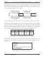
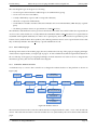
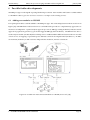
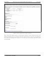
The elaboration of a specific UML1 use case diagram for GEOME has enumerated the actions of the users on
the platform, answering the previous question ”what should users be able and allowed to do?”. A use case
diagram is a description of steps or actions between a user (a person or an external software) and the system
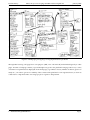
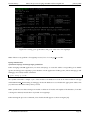
(Bittner 2003 [2]). GEOME use case is shown in Figure [1]. It covers user-system interactions and gives a global
view of the platform specifications. It illustrates the interaction between four components: the user, the web
server, the database and the calculation program.
1 UML: ”Unified Modeling Language is a standardized language for describing and visualizing the different parts of software systems. It
is used for software designing” Collins dictionary
2
BUSINESS REQUIREMENTS
Page 2
Pauline Emery
Master Project: Developing GEOME web-based platform
>$'("%?(
%))(..
'
"'
//
0+
"
"&.
;.0
-20
> #-,
.
$
,
=-
<44 *&$%+0"
-& *2)#$/ 4+0+'"0
!.(+
@$"(
'*+0 $.4$%$42
$+# 4$'
+
0&$)2 #'
0$-.
AB-'
+.4 " ".%$&
' 0+ -.6
0$'0
$/+ ".0+#
# +. /&$0
+#8' "&$+
$'
!(.
#-+
4
5$#"
'
@+(%,(
"*<#1) $+ "+19%,(
.,*&7
!"#$%&
'$#()*#%+ &%,%
;1.*%#1.(
"*<#1) %2& $02
&%,%.(,.
5$ )%#)*#%,1$2.
$+ %.6 $2#7 8$+
(29: &%,%
A&"
+0"
D3
='
January 2012
+.4
'
0+0
$/ /
-.0
".0
'
<46
/-. $. +.4
."/
0$-. 2' "&
' 8' 0
"6
!+0+>/-.
0&-# +.
4+0+)+'" 4 &-)2'0
'8'0"6
0$-.
%$' 2+#$' +
!8.+6$/ 5"+02&" 0--#'
.4
+
7+**$.,
"
"+0 '
0
- /&
"' 0 6$.*2
$
&
"
2
+
$/ 1 *&-,&
5
$
/
C*" 2#+0$-.
/+#/
&'
-#4"
.4 5 .'
+
'
5$#" /+0$
+," -0$5$
7+. >6+$# .
?
!+0+)+'"
=(< .(+9(+
-(%&./ 0+1,(./
(&1,. %2& &$(.
3*(+1(.
9,"-4+0+)+'":
!"#$%"&"'
!"#$%"&"'(")
(")*+,"'
*+,"'
-.
-./#$".0
/#$".0&"12"'0
&"12"'0
3"/"$%"' +.4
*&-/"''"' /-.0".0
5&-6/#$".0'
7+.+,"' 48.+6$/ +.4
'0+0$/ /-.0".0'
@$''*21)%,(.
%2& (A)B%2?(.
81#(.
A+#/2#+0$-.
*&-,&+6
4))(..
+(.*#,.
Figure 1: Use case diagram for GEOME prototype
On the platform, the user should be able to upload and access his own molecular data, download or use
corresponding environmental data, run different types of calculations and download the calculation results.
The user must define his datasets privacy status: private or public. If his dataset is private, he will be the only
one to have access and edition rights to it. If his dataset is public, other users can view and use it. Calculation
parameters as well as results will be accessible, therefore avoiding the user to repeat the same calculations and
to wait for the results. Each dataset is linked to a species. For structure purpose, each dataset is therefore part
of a study. Datasets related to the same species will be classified in the same study (see next page). As some
users would like to remain totally anonymous on the platform, a study can also be private and shared with a
restrictive circle of users. However, the aim of this platform is to be collaborative (giving access to environmental
data but also to other molecular data from a given species of interest), so the user will be encouraged to create a
private dataset in public study. This way, he could later on change his dataset privacy (e.g. when he will have
carried out enough private research on the topic) in order to make it public.
The primary roles of the web server are to deliver webpages on user request, to receive and process content from
users and to manage dynamic and static contents from webpages. From the web server point of view, the system
must be able to handle administration and user connection system, to carry out a data-control, to communicate
with a database system, to perform dynamic visualisation and mapping features, to fulfil communication with
other programs and to manage files and folders creation and e-mail notifications.
2
BUSINESS REQUIREMENTS
Page 3
Pauline Emery
2.3
Master Project: Developing GEOME web-based platform
January 2012
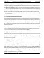
Paper prototyping
The best way to understand the expectations concerning the user-system interface is to design several paper
prototypes. Indeed, the paper prototyping technique supported GEOME creation phase by building a complete
web-site design before writing any programming code. Visualising hand-sketched drawings of the user-system
interface led to useful discussions and feedback from LaSIG supervisors and a concrete evolution over the weeks
of the global platform design. For GEOME interface, this evolution was done in three major steps illustrated in
Figure [2], [3] and [4].
The first step was to focus on a single user point of view enumerating the different actions done on the platform
(e.g. connexion to the web-site, upload and visualisation of data, selection of spatial analysis methods and
calculations). The results of this first step is shown in Figure [2].
Figure 2: First paper prototyping: defining the actions of a single user
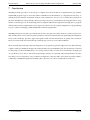
This first paper prototype was linear and outlined a problem of data classification. Indeed, the different datasets
needed to be organised into ”studies”. Each study is defined by a unique species. This way each dataset belongs
to a single study. This reflection led to the elaboration of a second hand-sketched drawing shown in Figure [3].
The user-system interface is composed of the previous different actions and of the new structure (e.g. study,
dataset, calculation and results). The second step consequently was a structure reviewing.
2
BUSINESS REQUIREMENTS
Page 4
Pauline Emery
Master Project: Developing GEOME web-based platform
January 2012
Figure 3: Second paper prototyping: reviewing the structure
This second draft resembles much more a web-site design and corresponds to the user wishes. However it had
several implementation problems: how to add a new study and a new dataset simultaneously in the database
(see page 4a in Figure [3]) ? How to generate only environmental data in the same form than the calculation
form (see page 5a) ? The webpage contents were therefore discussed and reorganisation of the information was
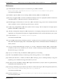
done by dividing the forms and the pages, leading to the final paper prototyping presented in Figure [4].
2
BUSINESS REQUIREMENTS
Page 5
Pauline Emery
Master Project: Developing GEOME web-based platform
January 2012
Figure 4: Third paper prototyping: solving implementation problems
Through this last step, each page has it own purpose (add, view or download) and is linked logically to other
pages. In terms of webpage contents, a special thought was given to the platform homepage. Moreover, a series
of statistics was planned to be displayed on the homepage (e.g. number of users, number of dataset, species of
study etc...) in order to give more visibility of the content of the platform for non-registered users, to show its
collaborative component and to encourage people to register to the platform.
2
BUSINESS REQUIREMENTS
Page 6
Pauline Emery
3
Master Project: Developing GEOME web-based platform
January 2012
Technical requirements
Technical requirements were considered to define which kind of technology to be used. They expose the core
features and the design pattern to take into account to fulfil the business requirements.
3.1
GEOME core features
The implementation of the core features (modules A, B, C, D and E) in Figure [5] was decided for the web-based
platform prototype. GEOME modules are divided in different categories of data and tools.
Figure 5: GEOME main interconnected modules
Data
A. Genetic geo-referenced data with presence or absence of the genetic markers
B. Environmental
! data
!
!
Tools
C. Genetic data upload interface
D. WebGIS environment for the integration of environmental and genetic data and their geo-visualisation
E. SAM module for the detection of loci associated with environmental parameters (Joost & al. 2007 [9])
Modules A, B and E are going to be detailed in the next subsections as they are existing elements. Module C
and D are described through-out this report as they are new features implemented during this Master project.
These two modules allow the connexion and interaction between the existing modules.
3
TECHNICAL REQUIREMENTS
Page 7
Pauline Emery
3.1.1
Master Project: Developing GEOME web-based platform
January 2012
Genetic geo-referenced data
Genetic data, provided by the users in text files, need to be characterised by geographic coordinates given in
latitude/longitude in decimal degrees (Latitude: [-90.00◦ , 90.00◦ ], Longitude: [-180.00◦ , 180.00◦ ]) with WGS842
geodetic datum in order to retrieve local environmental information. GPS devices or websites, like itouchmap
see ref. [7], help to find the latitude/longitude of a given location. Molecular datasets used for SAM are matrixes
with the presence (1) or the absence (0) of a given molecular marker type (e.g microsatellite markers or amplified
fragment length polymorphism (AFLP)). ”NaN” (Not-a-Number) text can be placed for a missing molecular
value. Each row of the matrix corresponds to a sampled individual, while the columns are organised according
to the sampled individual’s geographic coordinates and contain binary information (1 or 0) relating to the status
of the genetic marker. An optional field is the breed, usually used in livestockbreed. Table [1] is an example of a
sheep genetic data file, located in Europe, for a dataset constituted of 4 individuals.
Individual
Aa1
Aa2
Ab1
Ab2
Latitude
46.59
46.65
52.31
51.70
Longitude
7.86
6.65
-3.42
-3.22
Breed (optional)
Suffolk
Suffolk
Lincoln Longwood
Lincoln Longwood
Marker AA128
0
1
1
0
Marker AG128
1
1
NaN
0
Marker AG130
0
1
0
0
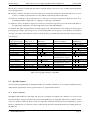
Table 1: Example of sheep genetic data file for a dataset constituted of 4 individuals
3.1.2
Environmental data
Worldwide datasets of 10 average climate parameters for global land areas were selected for the environmental
data of the platform. This way GEOME provides environmental data for users around the world. These datasets
are available through the Oxford School of Geography, the International Water Management Institute and the
Climatic Research Unit (New 2002 [13]) under the Open Database License. All datasets have a grid resolution of
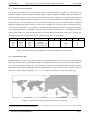
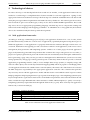
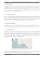
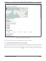
10-minute of angle latitude/longitude (≈ 20 × 20 km2 ) of the world land areas as shown in Figure [6].
(a) World scale
(b) Country scale
Figure 6: Visualisation of CRU grid represented by it cell centroids
2 WGS84: World Geodetic System is a standard for use in cartography, geodesy, and navigation. WGS 84 is the reference coordinate
system used by the Global Positioning System (GPS).
3
TECHNICAL REQUIREMENTS
Page 8
Pauline Emery
Master Project: Developing GEOME web-based platform
January 2012
Their common grid is composed of 566’261 points representing the centroid of each cell. This way only points
are stored instead of polygons. This concentrates all the information of a cell in a single element instead of four.
It is also faster and easier to associate a point in space to a point of the grid, by searching the nearest point of the
grid in a radius of 20 km.
The environmental datasets consist of 10 climate parameters, see Table [2]. Their values (given to each center
of the grid) were interpolated from a dataset of station average values for the period centred on 1961 to 1990
(New 2002 [13]).
Parameter
Precipitation
Cumul value of precipitation
Wet-days frequency
Mean temperature
Mean diurnal temperature range
Relative humidity
Sunshine duration
Ground-frost frequency
10m windspeed
Elevation
Nomenclature
pre
cvpre
rd0
tmp
dtr
reh
sunp
frs
wnd
elv
Units
Millimetres per month (mm/month)
Percentage (%)
Number of days with >0.1mm rain per month
Degree Celcius (◦ C)
Degree Celcius (◦ C)
Percentage (%)
Percentage of maximum daylength (%)
Number of days with ground-frost per month
Meter per second (m/s)
Kilometers (km)
Table 2: Parameter details of CRU/Oxford/IWMI grids
All grids, except elevation, have 15 columns: latitude, longitude, 12 monthly values (from January to December)
and an annual average value. Latitude and longitude columns correspond to the centre of each cell (10-minute
of angle latitude/longitude) of the grid and are given in degrees decimal. The elevation grid has 3 columns:
latitude, longitude and mean elevation.
Due to the variety of parameters and the worldwide resolution of this grid, it is possible to do association
models between the genetic geo-referenced data and the environmental data of the sampling regions. This
association model is compute by SAM calculation program.
3.1.3
SAM calculation program
Spatial coincidence allows to relate genetic characteristics (e.g. markers) of species with environmental parameters through joint coordinates. A simple calculation of correlation is not possible since it is a situation of
presence or absence of markers. To work through this obstacle, statistics have developed the concept of logistic
regression. The relationship of ”all or nothing” is replaced by a sigmoidal shape function, so that it is possible
to associate a probability of presence-absence of genetic markers according to environmental context.
SAM calculation program carries out multiple or univariate logistic regressions to test for association between
allelic frequencies at marker loci and environmental variables. A confidence level of models consisting of all
possible pairs (genetic marker x environmental parameter) is calculated to identify the most significant models
that possibly play a role in the adaptation process.
3
TECHNICAL REQUIREMENTS
Page 9
Pauline Emery
Master Project: Developing GEOME web-based platform
January 2012
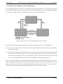
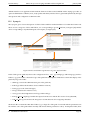
GEOME must therefore ensure the communication with ScytheSAM, a SAM calculation program developed
with Scythe Statistical Library in C++ open source programming language, in order to compute association
models. GEOME creates ScytheSAM input files, lounge the calculations and gives back the results to the user,
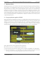
once the calculations are finished as shown in Figure [7].
selects its calculation
parameters for its dataset
generates the inputs
for ScytheSAM
Web‐based
interface
ScytheSAM
!"#$
sends e-mail notification
with a link to download
the outputs
computes calculations
and returns outputs
Figure 7: Schema of the interaction between the user, the web-based interface and the calculation program
ScytheSAM works with three input files: a genetic geo-referenced data file (e.g. Table [1]), its corresponding
environmental data file (e.g. Table [3]) and a parameter file (e.g. Table [4]). The environmental data file is
built thanks to a spatial query. This spatial query finds which local environmental parameters (e.g. from CRU
grid) must be linked to the individual sampling coordinates, as those coordinates do not correspond to the
coordinates of the grid centroid. The execution of this spatial query is the one of GEOME services.
Latitude
Longitude
46.59
46.61
52.31
51.70
7.86
7.03
-3.42
-3.22
Temperature
(◦ C)
16
16
13
13
Precipitation
(mm/month)
216
216
540
540
Elevation
(km)
1.560
0.827
0.236
0.265
Table 3: Example of environmental values data file for 4 given coordinates
The file parameter structure composition is detailed in Appendix B. It is based on the possible execution of
several logistic regressions methods, as spatial autocorrelation, spatial weighting, predictions, threshold or
permutations.
HEADERS YES
NUMVARENV 3
NUMMARK 3
NUMINDIV 5
DIMMAX 1
SPATIAL Longitude Latitude SPHERICAL NEAREST 10
AUTOCORR GLOBAL ENV
SAVETYPE END BEST 0.01
Table 4: Example of a parameter file for calculation
3
TECHNICAL REQUIREMENTS
Page 10
Pauline Emery
Master Project: Developing GEOME web-based platform
January 2012
The outputs of ScytheSAM depend on the calculation methods defined in the parameter file. The table containing
the results can be composed of different groups of statistical data. Each group is constituted of n rows and
m columns, where n and m represent respectively the number of environmental variables and the number of
genetic markers. These groups contain the following information :
1 Log Likelyhood2
2 Log Likelyhood1
3 Degrees of freedom
4 G value
5 P value for G
6 Null hypothesis rejected for G (default confidence level = 99%)
7 Wald for Beta 0
8 Wald for Beta 1
9 P value for Wald Beta 0
10 P value for Wald Beta 1
11 Null hypothesis rejected for Wald Beta 0 (default confidence level = 99%)
12 Null hypothesis rejected for Wald Beta 1 (default confidence level = 99%)
13 Dynamic null hypothesis analysis for G and Wald Beta 1 : Null hypothesis for G
14 Dynamic null hypothesis analysis for G and Wald Beta 1 : Null hypothesis for Wald Beta 1
15 Dynamic null hypothesis analysis for G and Wald Beta 1 : Cumulated test
A complete procedure on how to deal with the ScytheSAM outputs and to identify the more significant associations is given on http://www.econogene.eu/software/sam/ website.
The basis elements of the GEOME platform (inputs, tools, outputs) need to be integrate into the MVC software
architecture pattern in order to create the web-based platform.
3
TECHNICAL REQUIREMENTS
Page 11
Pauline Emery
3.2
Master Project: Developing GEOME web-based platform
January 2012
Model-View-Controller software architecture
In a web-based platform a Model-View-Controller (MVC) design pattern allows to clearly map the input,
processing and output tasks of a web-based platform. It is an important phase of the GEOME platform design
as it explains its technical behaviour and how each of its core features should interact.
Figure 8: Model-View-Controller design pattern, Source ref. [20]
M. The model represents the application database and the rules that govern its access and update.
V. The view renders the contents of a model. It accesses data through the model and specifies how that data
should be presented.
C. The controller translates interactions with the view into actions to be performed by the model. In a web
application, user interactions appear as GET and POST HTTP requests. The actions performed by the
model include activating processes or changing the state of the model. Based on the user interactions and
the outcome of the model actions, the controller responds by selecting an appropriate view.
Here following is the explanation of the MVC design pattern applied to GEOME platform prototype, with its
UML class diagram (Model), its website design (View) and its website skeleton (Controller). The previous core
features (module A, B, C, D and E) are used all around the MVC design pattern. In other word, the core features
are the pieces of the platform and the MVC design pattern is the way to assemble them.
3
TECHNICAL REQUIREMENTS
Page 12
Pauline Emery
3.2.1
Master Project: Developing GEOME web-based platform
January 2012
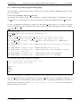
Model: UML class diagram
The best way to illustrate the Model of MVC design pattern is using a Unified Modeling Language (UML)
class diagram. This schema is a static description of the classes and their attributes of GEOME database. It is a
key element of the prototype design, because it must include as much as possible a general behaviour of the
platform. Indeed, it is not recommended to alter the database structure (by adding connections or attributes)
once it has been created, due to the need of data persistence. Figure [9] illustrates connections between different
classes with their cardinality and their level of association (aggregation ♦, composition , specialisation ↑).
> linked
with a spatial query
Figure 9: UML class diagram of GEOME
This UML class diagram is composed of 19 classes that can be divided in four categories: the user configuration
(e.g. user and authentication group classes), the molecular data (e.g. study, dataset, individual and marker
classes), the calculations (e.g. run calculation, methods and parameters classes) and the environmental data (e.g.
CRU data and the 9 climate parameters classes). The dataset class is the central node of the diagram.
3
TECHNICAL REQUIREMENTS
Page 13
Pauline Emery
Master Project: Developing GEOME web-based platform
January 2012
The class diagram logic can be given as following:
• a user has personal information and belongs to an authentication group;
• a user can work on several studies;
• a study is defined by a species and is composed of datasets;
• a dataset is composed of individuals;
• a individual is related to markers and can be linked to the environmental data (CRU data) by a spatial
query
• all climate parameter classes are specialisation of CRU data class;
The attributes of the different classes give basic information about the class and should not be repeated from
one class to the other if tables are correctly linked. The individual and the CRU data classes have spatial data in
it (latitude and longitude attributes). In order to do a spatial query, those tables need to be specified as point
feature classes (with the three dotes symbol). The climate parameter classes are not point feature classes but
they are directly linked to the CRU data by a specific identification code.
3.2.2
View: Website pages
The design and content of the website pages (the View) matches the last step of the paper prototyping technique
of the business requirements, see Figure [4] on page 6. In fact it fulfils the technical requirements thanks to
the second step of the paper prototyping technique in which attention was taken on how to integrate the
information given by the user into the UML class diagram.
3.2.3
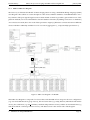
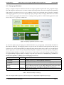
Controller: Website skeleton
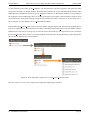
A schematic way to conceive the Controller is to design the website skeleton of the platform as shown in
Figure [10].
Homepage
User login
Tutorial
Overview studies
Add study
Methods
View study
Add dataset
Download
environmental data
View dataset
View calculation
Download
calculation results
Add calculation (1)
select environmental data
Add calculation (2)
select methods
Add calculation (3)
run calculation
Figure 10: Website skeleton
The interactions between the Controller and the Model are implied with the ”add”, ”view” and ”download”
actions. The relation between the Controller and the View are symbolised by the arrows between the different
pages.
3
TECHNICAL REQUIREMENTS
Page 14
Pauline Emery
4
Master Project: Developing GEOME web-based platform
January 2012
Technological choices
In order to develop a web-based platform from scratch in four months, a web application framework was
needed to avoid having to re-implement basic features needed for each web application. Opting for the
appropriate framework needed several steps. The first step was to find the standard frameworks that would
satisfy the prototype technical requirements and LaSIG laboratory further use. The technological choices have
been focussed on open-source technologies, as they are also able to fulfill GEOME requirements. The second
step was to choose an appropriate programming language. The final step was to compare the existing web
frameworks in that language with mapping possibilities. As GEOME is an evolving platform, the technical
choices also underline briefly the future possible developments.
4.1
Web application frameworks
According to DocForge community project ref.[14], a web application framework is a set of codes, which
provides functionality common to a whole class of applications, specifically designed to help developers to
build web applications. A web application is a program, which interacts with users through a web browser over
a network. Web frameworks typically provide core features common to web applications, such as user session
management, data persistence and templating systems. Unlike a set of static pages, most web application
pages are dynamically generated from persistent data. Frameworks can provide generic user accounts, so
people can register, login and reset passwords. Frameworks can automatically check and require authentication
before generating a page. They can also provide user management for administrators (create user accounts,
manage permissions, change page content, generate reports or alter data). Frameworks also provide a consistent
application programming interface (API) to access multiple data storage systems, to simplify storage and
retrieval of data objects, such as with object-relational mapping (ORM). The most popular overall design pattern
of web application frameworks is Model-View-Controller (MVC). The initial code of the framework evaluates
the URL and passes responsibility to the appropriate application controller. The controller then performs
any necessary actions with the application’s model and then let the view build the actual response content.
Webpage templates help keeping business logic separate from display logic. The templating system may be
keyword replacement or generated content such as form fields from parameters. Most often the framework will
make available developer-defined fields or data structures available within templates (i.e. push). Conversely a
templating system may request data back through the framework (i.e. pull). There are many web application
frameworks, as shown in Table [5]:
Language
Java
PHP
Python
Ruby
Framework names
Apache Struts / JavaServer Faces / Jt Design Pattern Framework / Apache Wicket
CakePHP / CodeIgniter / Symfony / Zend Framework
Django / Grok / Pylons / Turbogears / web2py / Pylatte / repoze.bfg
Ruby on Rails / Ramaze
Table 5: Non-exhaustive list of web application frameworks
4
TECHNOLOGICAL CHOICES
Page 15
Pauline Emery
4.2
Master Project: Developing GEOME web-based platform
January 2012
Python programming language
Python programming language has been chosen, due to previous LaSIG programming backgrounds and because
it fulfils the open source criteria for the platform. Herebelow, Python main characteristics are given according to
Python Official website [19].
Figure 11: Python programming language icone
Python is a powerful dynamic programming language implemented under an open source license that is used
in a wide variety of application domains. Python’s core concept is keeping things understandable. It is available
for all major operating systems: Windows, Linux/Unix, OS/2, Mac, Amiga, among others. The same source
code will run unchanged across all implementations. Python also comes with complete documentation. The
developer and user community maintains a wiki, hosts international conferences and contributes to online code
repositories. Python is often compared to Perl, Ruby or Java. Its key distinguishing features include:
• clear and readable syntax (which is sensitive to indentation, so very few brackets needed);
• strong introspection capabilities;
• intuitive object orientation;
• full modularity, supporting hierarchical packages;
• exception-based error handling;
• high level dynamic data types;
• extensive standard libraries;
• extensions and modules easily written in C, C++ (or Java for Jython, or .NET languages for IronPython).
Among Python web-frameworks cited in Table [5], two are largely used in the field of web-mapping applications:
Pylons with MapFish and Django with Geodjango. Pylons framework is in an evolving period (Pylons Project
FAQ [15]), as Pylons 1.0 code-base has hit a point of diminishing returns in flexibility and extendibility. The
Pylons web framework 1.x line will not be enhanced. The future of Pylon-style web application development is
Pyramid. Its initial release was in December 2010. This recent outcome brings about possible documentation
and features problems. Pyramids therefore is not as mature as Django (initial release was in July 2005). Django is
renowned to be a rapid-to-learn web framework, which emphasises the principle of DRY (Don’t Repeat Yourself).
The Django documention is understandable for both the experienced and inexperienced Python/Django user.
The Django Book (Holovaty 2009 [5]) is available online for free. Django was therefore chosen for these global
reasons to be used as the web-framework of GEOME prototype. However Django has also many specifications
which have confirmed further on this choice.
4
TECHNOLOGICAL CHOICES
Page 16
Pauline Emery
4.3
Master Project: Developing GEOME web-based platform
January 2012
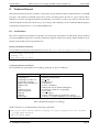
Django specifications
Django is a high-level Python web framework that encourages rapid development and clean, pragmatic design.
It provides high-level abstractions of common web development patterns, shortcuts for frequent programming
tasks, and clear conventions for how to solve problems. It can be associated with others programs to establish
web-mapping applications, as shown in Figure [12]. Django is improved by GeoDjango skills when it is needed
as a world-class geographic web framework. Geodjango makes possible to build webGIS applications and
harness the power of spatially enabled data.
Figure 12: Django specification, Source ref. [21]
As shown in Figure [12], GeoDjango uses different datastore (e.g. PostgreSQL and PostGIS) and libraries
(described in Table [6]). The mapping features are given in the user interface with OpenLayers and jQuery.
OpenLayers is a pure JavaScript library for displaying map data in web browsers, with no server-side dependencies. jQuery is a cross-browser JavaScript library designed to simplify the client-side scripting of HyperText
Markup Language (HTML). GeoDjango manages many serialised data (e.g. Keyhole Markup Language (KML),
Geography Markup Language (GML)). Geodjango composition give therefore to GEOME many possibilities for
further developments (e.g. adding layers and mapping interactions).
Library
Open Source Geospatial
Consortium
Geospatial Data Abstraction Library
Cartographic Projections
Library
Name
OSGeo
Mapnik
Mapnik
GDAL
PROJ.4
Use
Is a simple feature implementation for SQL specification, which handles
geometry objects (e.g. PointField, MultiPointField etc.).
Reads and writes to a variety of vector file formats, (e.g. shape files).
Manages spatial reference systems and projections (e.g. the mercator projection commonly used by Google Maps, MapQuest) and ensures that
geometry objects stored in PostGIS use the appropriate projection.
Builds customised maps and handles rasterizing vector objects when large
datasets are encountered.
Table 6: Libraries used by GeoDjango
After choosing the technological tools, the next step was to implement the platform prototype.
4
TECHNOLOGICAL CHOICES
Page 17
Pauline Emery
5
Master Project: Developing GEOME web-based platform
January 2012
Implementation
GEOME implementation is the realisation of the technical requirements through programming and deployment, with the tools selected during the technological choices. The purpose of this section is to understand
the general behaviour of Django. The user manual (Appendix C) gives a general view of the platform by
guiding the user through each webpage of GEOME. The technical manual (Appendix D) and Django’s online
documentation ref.[5] give more technical and programming details about GEOME implementation. Specific
features implemented and the webGIS environment are also presented in order to underline reflections that
came across during the implementation. GEOME hardware configuration and dataset tests are lastly exposed to
comprehend its performance.
5.1
Django specification applied to GEOME
Django web framework is designed to encourage loose coupling and strict separation between the pieces of
an application (e.g. data access logic, business logic and presentation logic) . This way it is possible to make
changes to one particular piece without affecting the others. The overall design of a database-driven Django
web application is given in Figure [13]: it combines MCV design pattern, configuration settings (settings.py,
manage.py and django-admin.py) and interactions with the browser, the web server and the database.
Figure 13: Django overview, Source ref. [22]
Django applies the MVC software architecture in the following way:
M is the data-access portion, is handled by Django’s database layer;
V is the portion that selects which data to display and how to display it, is handled by views and templates;
C is the portion that delegates to a view depending on user input, is handled by the framework itself by
following your URLconf and calling the appropriate Python function for the given URL.
5
IMPLEMENTATION
Page 18
Pauline Emery
Master Project: Developing GEOME web-based platform
January 2012
Because the Controller is handled by the framework itself, Django is known to have an MTV (Model-TemplateView) design pattern:
M stands for ”Model,” the data access layer. This layer contains the information about the data: how to access
it, how to validate it, which behaviors it has and the relationships between the data.
T stands for ”Template,” the presentation layer. This layer contains presentation-related decisions: how
something should be displayed on a webpage or other type of document.
V stands for ”View,” the business logic layer. This layer contains the logic that accesses the model and defers to
the appropriate template(s). It is the bridge between models and templates.
To illustrate this MTV design pattern, the Table [7] gives the relation between the webpage from the paper
prototyping (see Figure [4] on page 6), its corresponding URL (in urls.py), the view function executed (in
views.py), the objects and conditions of the model (in models.py) and the html file returned in response by the
view function.
Webpage
(paper prototyping)
1a Homepage
1b Tutorial
1c Methods
2a Login
2b Logout
3 Overview
4a New study
4b View study
URL
(http:..root.../)
/homepage
/tutorial
/methods
/accounts/login
/account/logout
/overview
/study
/study/id1
View
(function)
staticview()
staticview()
staticview()
login required()
logout view()
on going studies()
create study()
view study()
4c New dataset
5a View dataset
/id1/dataset
/id1/dataset/id2
add dataset()
view dataset()
5b Download data
5c Run calculation
6 Download results
/id2/envdata
/id2/calc/id3
/id3/results
download env data()
add calculation()
view results()
Model
(object |condition)
Dataset |all
Study |active, user
Study|new object
Study|id1, public (or private but user is owner)
Dataset |new object
Dataset|id2, public (or private but user is owner)
Dataset|id2
Calculation|id3
Calculation|id3
Template
(HTML file)
1a homepage.html
1b tutorial.html
1c methods.html
default login.html
1a homepage.html
3 overview.html
4a new study.html
4b view study.html
4c add data.html
5b view dataset.html
5b env data.html
5c calculations.html
6 results.html
Table 7: Flow graph summary of GEOME
5.2
Specific features
Several features implemented in GEOME needed to be carefully examined to avoid conflicts with the business
and technical requirements. Three specific features are explained here bellow.
5.2.1
Forms validation
GEOME needed handle user data input. The best way to integrate user inputs into a database is to create a form
from the database. Django automatically verifies if the field types are respected. This feature could be used to
create new studies or datasets. However the user input file (molecular data file) had to be handled by a specific
function, called by the view function, which verifies the file structure and information before adding them into
the database.
5
IMPLEMENTATION
Page 19
Pauline Emery
5.2.2
Master Project: Developing GEOME web-based platform
January 2012
Access verification
As GEOME must assure privacy settings, a control is done before loading each webpage to be sure that the user
is authorised to have access to it. Indeed, the urls are accessed by the study id and the dataset id. If for instance
the dataset 1 of study 2 is private, we only want its owner to access the urls http://lasigpc49.epfl.ch:
8080/study/2/dataset/1/. This test is done in the view functions and return an ”Access denied” page if
the user is not the owner when the dataset is private.
5.2.3
ScytheSAM files creation
In order to do model computation, ScytheSAM needs three different inputs (see 3.1.3 SAM calculation program
on page 9). The aim was to duplicate at least at possible the information of the database into files. Indeed, as
datasets start growing, it is importan to preserve storage memory. This is why, Django creates the molecular
inputs only once for all calculations as this file is not changed from a calculation to the other.
5.3
Web-GIS environment
As GEOME aims to be a web-GIS platform for molecular data visualisation and spatial query realisation, its
implementation required the use of mapping features (i.e. OpenLayers) and spatial databases (i.e. PostGIS).
5.3.1
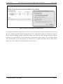
OpenLayers mapping
OpenLayers is an Open Source JavaScript library released under the FreeBSD License. OpenLayers implements
a JavaScript API for building rich web-based geographic applications, similar to the Google Maps with one
important difference - OpenLayers is Free Software, developed for and by the Open Source software community.
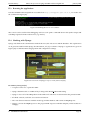
OpenLayers allows dynamic maps in webpages. It can display map tiles and markers. A basic example of
markers display in OpenLayers map is given in Figure [14].
Figure 14: Basic example of mapping features with OpenLayers
OpenLayers API is or will be used in GEOME for instance to add layers, to create clusters of points depending
of the scale and to show for instance only the individuals related to a given marker.
5
IMPLEMENTATION
Page 20
Pauline Emery
5.3.2
Master Project: Developing GEOME web-based platform
January 2012
PostGIS spatial database
A specific aspect of GEOME is that it must be able handle spatial objects (e.g. point objects) and to relate them
to other spatial object thanks to spatial queries (e..g to relate CRU database to the individuals). By installing
PostGIS many functions are available to compute spatial queries.
5.4
Tests with different datasets
After finalising the prototype implementation, tests with three real datasets were done as shown in Table [8].
Species
Frog
Brown bear
Goat
Location
France
Sweden
Europe
Individuals
139
730
1220
Markers
249
224
102
Time to upload
1 min
4 min
3 min
Time to download
4 sec
15 sec
29 sec
Table 8: Datasets parameters and time results
The time to upload user inputs is important as the platform needs to validate each information given and
to incorporate them into the database (average time: 41’000 entries per minute). The time to download
environmental files are quicker as the matrixes generates are smaller (average time: 40 individuals x 117
environmental values / second). As ScythSAM calculation times depend of the parameters chosen and of the
dataset configuration, they can not be compared directly in this table.
5.5
Hardware configuration
GEOME implementation was realised on a single machine. The development server, the geo-environmental data
(CRU data) and the program executing the calculation are handled on the same machine. This 8-cores-computer
will initially take care of the calculation parallelization in the different nodes locally available. The hardware
configuration in a single machine helped to the established the communication between the different actors of
the platform (e.g. Django, PostgreSQL, ScytheSAM), however it would possible to do remote communication in
the future.
For the moment, GEOME works with the core features presented in the technical requirements. Possible further
developments will be presented here below.
5
IMPLEMENTATION
Page 21
Pauline Emery
6
Master Project: Developing GEOME web-based platform
January 2012
Possible further developments
GEOME prototype was designed expecting further improvements. New modules and features could be added
to GEOME in order to give new services to its users or to improve the existing services.
6.1
Adding new modules to GEOME
Four principal modules could be added to GEOME prototype. The relationships between them are shown in
Figure [15]. GEOME future web-based services could indeed be provide two complementary approaches to
measure local adaptation: a spatial analysis approach (Joost & al. 2007 [9], existing module E) and a theoretical
approach in population genomics (e.g. Foll and Gaggiotti 2008 [3], future module F) . GEOME will also have a
result analysis module (module H) that will help users to understand the difference between the two models.
A new service of mapping of potential species habitats could also be implemented (modules G). An HPC
environment (module I) would accelerate and parallelize module E, F and G calculations.
Figure 15: Possible new interconnected modules to GEOME, Source ref. [10]
6
POSSIBLE FURTHER DEVELOPMENTS
Page 22
Pauline Emery
Master Project: Developing GEOME web-based platform
January 2012
Modules A, B, C and D are described in Figure[5] on page 6.
F. Theoretical population genetics module (BayeScan) to differentiate neutral loci from loci under selection (Foll
and Gagiotti 2008 [3]);
G. Predictive habitat modelling module to generate maps of potential habitat. It will include a statistical tool
able to run Generalized Linear Models (GLM), in connetion with module E. Indeed, the SAM approach
is not restricted to molecular data and can also be used to detect environmental variables significantly
associated with species presence data.
H. Result analysis module with visual facilities for the comparison of results provided by modules E and F;
I. High Performance Computing (HPC) module connected up to modules E, F and G to guarantee a powerful
processing capacity.
6.2
Enhancing environmental data features
Django can handle multiple-database interactions ref. [16] and remote database connexions (by defining its host
connexion). As the relation between a position and an environmental parameter is done by a spatial query, it
is possible to access other regional or worldwide geo-environemental databases. For regional regions, it will
be necessary to create a dynamic environmental data form, in order to give to possibility to the user to only
choose available environmental data (a spatial test will be done on the dataset location before generating the
environmental data form).
Thanks to Mapnik (see Figure [6] on page 17) tiles of existing environmental databases can be created at different
scales (e.g. geographic or time scales) and be added on the interactive map of the dataset. This feature will give
to users more information about the environmental data available on GEOME.
6.3
Improving collaboration between users
To improve the collaboration between users, an idea would be to give them more tools to interact. It would
be possible to create a forum, see ref. [17], where users could add links to scientific articles and reviews from
their datasets, as well as general comments on GEOME. Those tools will favour the emergence of a landscape
genomics interactive community.
6.4
Deploying Django to a production server
For now GEOME is accessible with EPFL virtual private network (VPN) connection under the url: http:
//lasigpc49.epfl.ch:8080/. A domain name like for instance http://www.geome.org need to be
bought before deploying Django to a production server. It is necessary to have a restricted circle of user testing
and given feedback of the platform. It is also important to find out which is the limited number of simultaneous
client connections in order to avoid that the server becomes unresponsive. This way GEOME will handle final
details/problems with the implementation. Django supports Python’s standard, called WSGI (Web Server
Gateway Interface). This means that Django can run on any server that supports the rather simple WSGI
standard. However Apache server with mod python, see ref. [18], historically has been the suggested setup for
using Django on a production server (Holovaty 2009 [5]).
6
POSSIBLE FURTHER DEVELOPMENTS
Page 23
Pauline Emery
7
Master Project: Developing GEOME web-based platform
January 2012
Conclusion
GEOME presently provides tools necessary to compute association models in a complementary way with the
ScytheSAM program. It gives access the CRU worldwide environmental data, to computational resources, to
shared molecular datasets and spatial analysis result calculations. It is for now a collaborative platform in
the sense that datasets can be shared, while preserving user privacy constraints by allowing the latter to keep
studies or datasets private. It needed important conceptual and technical steps before being able to program
and meet the business requirements. Those steps were decisive for choosing an adapted set of programming
tools (i.e. Python and Django) which fulfilled the technical requirements.
GEOME prototype is now able to provide the whole circle of people active in the study of evolutionary processes
and of biodiversity conservation in general with relevant environmental data sets, permitting the implementation of the landscape genomics approach together with relevant information on spatial autocorrelation.
However, it first needs to be first tested by a small group of users to receive their feedback.
The next main important step will be the integration of a population genomics approach to be able to directly
compare results provided by both approaches (BayeScan developer, Dr Matthieu Foll, has already been contacted
for this purpose). Then GEOME will go on evolving, until it reaches a certain level of maturity to be deployed
on a production server. Due to web technological improvements, it is expected web-based platforms to become
new daily tools for scientists to carry out their investigations, to discuss and to share their researches within a
community. GEOME final platform should be able to become one of those web-based research tools.
7
CONCLUSION
Page 24
Pauline Emery
Master Project: Developing GEOME web-based platform
January 2012
Acknowledgements
Many people deserve my deepest appreciation and thanks. I am grateful to LaSIG direct supervisor Stéphane
Joost and his collaborators, Sylvie Stucki and Nicolas Lachance-Bernard, who guided and advised my work
during all this semester. I would like to thank Thomas Heinis for is UML class diagram recommendation.
Elisabeth Salazar deserves a special thought for the chatting and relaxing moments at LaSIG. I need also
to express my gratitude to my dear friends Julien Eberle and Matthias Brändli for their technical support
concerning Django and to Professor Elizabeth Wentz and my family for carefully proof-reading this report.
Finally I would like to thank my responsible professor at EPFL, François Golay, who supported this project to
the EPFL’s administration.
ACKNOWLEDGEMENTS
Page 25
Pauline Emery
Master Project: Developing GEOME web-based platform
January 2012
References
[1] E. Barraud, 2011 Evolution of species is recorded in the genes, Mediacom EPFL
http://actu.epfl.ch/news/evolution-of-species-is-recorded-in-the-genes/
Last visited: December 2011
[2] K. Bittner, I. Spence, 2003. Use case modeling. Addison-Wesley. ISBN-13: 978-02017-09-131.
[3] M. Foll, O. Gaggiotti, 2008. A Genome-Scan Method to Identify Selected Loci Appropriate for Both Dominant and
Codominant Markers: A Bayesian Perspective. Genetics 180, 977-993
[4] R. Holderegger, D. Herrmann, D. Poncet & al., 2008. Land ahead: using genome scans to identify molecular
markers of adaptive relevance. Plant Ecology & Diversity, 1, 273-283.
[5] A. Holovaty, J. Kaplan-Moss, 2009. The Definitive Guide to Django: Web Development Done Right, Apress
publisher, Web ISBN: 1-4302-1936-X
[6] J. Kozak, C. Estreguil, K. Ostapowicz, 2008.European forest cover mapping with high resolution satellite data: The
Carpathians case study, International Journal of Applied Earth Observation and Geoinformation, 10, 1, 44-55
[7] I-touch website http://itouchmap.com/latlong.html
Last visited: December 2011
[8] S. Joost, 2009. Early stirrings of landscape genomics: Awaiting next-next generation sequencing before take-off,
FAO/IAEA International Symposium on Sustainable Improvement of Animal Production and Health, 8-1,
Vienna, Austria
[9] S. Joost, A. Bonin, M.W. Bruford, L. Després, C. Conord, G. Erhardt, P. Taberlet, 2007. A Spatial Analysis Method (SAM) to detect candidate loci for selection: towards a landscape genomics approach to adaptation.,
Molecular Ecology, 18: 3955–3969.
[10] S. Joost, A. Pointet, N. Ray, S. Vuilleumier, 2010 Application for CTI funding
[11] D.B. Lowry DB, 2010. Landscape evolutionary genomics. Biology Letters, vol 6. no.4 502-504
[12] S. Manel, M. Schwartz, G. Luikart, P. Taberlet, 2003. Landscape genetics: combining landscape ecology and
population genetics. Trends in Ecology & Evolution 18, 189-197.
[13] M. New, D. Lister, M. Hulme, I. Makin, 2002 A high-resolution data set of surface climate over global land areas,
Climate Research, Clim Res 21 p°1–25
[14] DocForge community project with an open wiki for software developers, 2011 Web application framework,
http://docforge.com/wiki/Web_application_framework
Last visited: December 2011
[15] Pylons Project FAQ http://docs.pylonsproject.org/en/latest/faq/pylonsproject.html
Last visited: January 2011
REFERENCES
Page 26
Pauline Emery
Master Project: Developing GEOME web-based platform
January 2012
[16] Django: multiple-database interactions https://docs.djangoproject.com/en/dev/topics/db/
multi-db/
Last visited: January 2011
[17] Django: create a forum http://code.google.com/p/django-forum/
Last visited: January 2011
[18] Django: mod python http://www.djangoproject.com/r/mod_python/
Last visited: January 2011
[19] Python Programming Language – Official website http://python.org
Last visited: December 2011
[20] Java
BluePrints,
Model-View-Controller
http://java.sun.com/blueprints/patterns/
MVC-detailed.html
Last visited: January 2012
[21] Odeon consulting group http://od-eon.com/presentations
Last visited: January 2012
[22] Python and Django blog timchen119.blogspot.com
Last visited: January 2012
REFERENCES
Page 27
Pauline Emery
REFERENCES
Master Project: Developing GEOME web-based platform
January 2012
Page 28
Pauline Emery
Master Project: Developing GEOME web-based platform
January 2012
Appendices
A
Inventory of web-based platforms in population genetics topics
Nameof the
Web platform
Function
Accessmode
URL
BIOPORTAL
Phylogenomic analysis, population genetics and highthroughput sequenceanalysis
Free
http://www.bioportal.uio.no
GeneGrid
Reliableand scaleableaccess to largevolumes of public
and privatebiological data. Services to allow the
generation and analysis of cancer and infectious disease
genetic information fromvarious distributed sources
Commercial
http://www2.besc.ac.uk/
GOTreeMachine
(GOTM)
A GeneOntology (GO) enrichment analysis tool. It
compares auser-uploaded genelist with all GO categories
to identify thosewith enriched number of user-uploaded
genes. Its primary purposeis to help users sort for
interesting patterns in genesets (Zhang et al. 2004).
Free
http://bioinfo.vanderbilt.edu/
License: GNU GPL
gotm/
GENOME Canada
Bioinformatics
Platform
(BioMOBY )
Webservices for interoperability between biological data
hosts and analytical services. GenomeAlberta and
GenomeCanadafund theproject through aBioinformatics
Platform. GenomeAlbertaand GenomeCanadaarenotfor-profit organizations leading Canada’s national strategy
on genomics with $ 600 million in funding fromthe
Canadian federal government.
Freely availablethrough
open sourcelicenses to
ensurethat Platform
resources areaccessibleto
all GenomeCanada
researchers and easily
utilized
http://www.gcbioinformatics.
ca/
GENOUEST
(Genocluster
platform)
Bioinformatics platformoffering completeset of tools in
bioinformatics, public databanks updated on adaily basis,
and arangeof links to seminars, training courses, platform
news.
This is apublic platform
providing freeservices. On a
paying basis, GENOUEST
can carry out specific
bioinformatic projects and
training.
http://www.genouest.org
GEY SIR (NIAID)
A web application designed to correlatecase-control
association datawith genetic and physical maps of the
human genome, including key human genes associated
with host immuneresponse. This web platformwas
developed by theNational Center for GenomeResources
(http://www.ncgr.org/) as part of apopulation genetics
project funded by theNational Instituteof Allergy and
Infectious Diseases
GEY SIR is publicly
availablefor the
visualization and analysis of
human genomic
neighborhoods and SNP
variants.
http://geysir.ncgr.org
SWISS-MODEL
A fully automated protein structurehomology-modeling
server, accessibleviatheExPASy web server, or fromthe
programDeepView (Swiss Pdb-Viewer).
Protein modelling is
accessibleto worldwide
biochemists and molecular
biologists (Arnold et al.
2006).
http://swissmodel.expasy.org
BABELOMICS
A completesuiteof web tools for functional analysis of
genome-scaleexperiments. Babelomics 3.2 includes the
useof web services and Web 2.0 technology features, a
user interfacewith persistent sessions and an extended
databaseof geneidentifiers. (Al-Sharour et al. 2006).
Free, users may register and
subscribeto amailing list,
every user has a1.5Gb of
disk quota
http://www.fatigo.org/
PASE
Visualization of all thedimensions of ‘OMIC’ datafrom
genomic, transcriptomic, and proteomic domains (Hishiki
2006)
Free
http://www.genelexpo.jp/
GeneOMIMViewer/jsp/
viewer.html
KOBAS
Annotation of DNA sequences (Wu et al. 2006), etc.
Freeregistration required,
dedicated user space
http://kobas.cbi.pku.edu.cn/
GVP (Green
Visions Plan)
A web-based platformto support interactiveenvironmental
planning. Partnership between Southern California’s state
land conservancies and theUniversity of Southern
California, was forged to createavisionary plan and
practical planning tools to promotehabitat conservation
(Maps of Target Species Habitat), watershed health and
recreational open space(Ghaemi et al. 2009)
Free, login required
http://gv-server.usc.edu/
GVWebTools_public_v2/
viewer4.16/signIn.asp
BIOS
(Biogeographic
Information &
observation System
BIOS is asystemdesigned to enablethemanagement,
visualization, and analysis of biogeographic datacollected
by theDepartment of Fish and Gameand its Partner
Organizations. BIOS facilitates thesharing of thosedata
within theBIOS community.
Open to thepublic (only
non-sensitivedataare
included) and restricted
access for additional secured
layers included
http://bios.dfg.ca.gov/
CARES
A Decision Support Systemfor Planning and Management
of SustainableLivestock Production in theMidwest
Free
http://cares.missouri.edu/
projects/completed/old/
LP.aspx
(last accessed -March 2010)
http://www.omii.ac.uk/
repository/project.jhtml
http://www.greenvisionsplan.
net/html/welcome.html
Figure 16: Non-exhaustive list of web-based platforms dedicated to population genetics topics. Source ref.[10]
An interesting example is the web-based service platform, BIOPORTAL, developed at University of Oslo for
phylogenomic analysis, population genetics and high-throughput sequence analysis. BIOPORTAL is one of the
largest public available computer resource with a cluster of 300 dedicated computational cores.
A
INVENTORY OF WEB-BASED PLATFORMS IN POPULATION GENETICS TOPICS
Page 29
Pauline Emery
A
Master Project: Developing GEOME web-based platform
INVENTORY OF WEB-BASED PLATFORMS IN POPULATION GENETICS TOPICS
January 2012
Page 30
Pauline Emery
B
Master Project: Developing GEOME web-based platform
January 2012
ScytheSAM parameter file structure
Each line must begin with the name of the parameter. If a parameter is optional (F for ”Facultatif”), the entire
line can be omitted. The required parameters are marked with an (O for ”Obligatoire”). The choices are
bracketed.
- FILENAME (F) (These details can be provided as an argument to the program) Name(s) of file(s) containing
the data (If the files are separated, write first the environmental data and second marker data)
- HEADERS (F) presence or absence of names for variables [Y, N]. These names will be read on the first line. If
no headers, the environmental variables are numbered P1, P2, P3 ... and markers M1, M2, M3.
- NUMVARENV (O) Number of columns in environmental data file
- NUMMMARK (O) Number of column in genetic data file
- NUMINDIV (O) Number of individuals per dataset
- COLSUPENV (F) Inactive columns for environmental data file. They are identified by their name if HEADERS
is True, or by their number [0, ..., N-1] if headers is False.
- COLSUPMARK (F)Inactive columns for genetic data file. They are identified by their name if HEADERS is
True, or by their number [0, ..., N-1] if headers is False.
- DIMMAX (F) Maximum size of the calculation for multivariate analysis [1 = univariate, 2= bivariate, 3 =
trivariate ...]. DIMMAX is 1 if omitted.
- SPATIAL (F) Names (or numbers) columns for longitude and latitude coordinate type [SPHERICAL,
CARTESIAN], neighborhood type of calculation [DISTANCE, GAUSSIAN, BISQUARE, NEAREST] scale
parameter (bandwidth or number of neighbors as appropriate)
- AUTOCORR (F) (requires SPATIAL field) autocorrelation type [GLOBAL, LOCAL, BOTH], variables [ENV,
MARK, BOTH] and number of permutation (by default 9999)
- GWR (F) (requires SPATIAL field)
- IDINDIV name column id env name column id mark; gives the name of the ID columns for each file
- SUBSETVARENV (F) Selection of geographic data, list data to consider
- SAVETYPE (O) Backup type: in real time or at the end [REAL END], backup (or not) of all data [ALL, BEST], if
BEST, p-value limit for model selection
/ / Settings supervision
1: Input file name, environment variable file names
2: Name parameter file
3: Number of environment variables
4: Number of genetic markers
5: Number of lines
6: Block Size
7: Number of calculations for Windows and Unix
B
SCYTHESAM PARAMETER FILE STRUCTURE
Page 31
Pauline Emery
B
Master Project: Developing GEOME web-based platform
SCYTHESAM PARAMETER FILE STRUCTURE
January 2012
Page 32
Pauline Emery
C
Master Project: Developing GEOME web-based platform
January 2012
User Manual : Tutorial
This tutorial gives guidelines on how to use GEOME. It is divided in subsections corresponding to the main
steps to follow. If you are a GEOME new comers, please read this Tutorial before adding your own data.
C.1
Homepage
GEOME home page gives you general information about GEOME. This page explains the philosophy of the
platform. It shows a series of statistics with basic information about each dataset. It gives references to open
source environmental data and to scientific articles.
Figure 17: Tutorial: View GEOME homepage
At any time, you can click on a part of the menu to come back to one of the principal sections (e.g. Homepage,
Tutorial, Methods, User).
C
USER MANUAL : TUTORIAL
Page 33
Pauline Emery
C.2
Master Project: Developing GEOME web-based platform
January 2012
User registration
In this development period, accounts are given directly by the administrator. If you are interested in joining
GEOME, please write an e-mail to [email protected], please specify your name, first name, affiliation,
location and e-mail. Once you receive your user account, you can access the ”User” section of the general menu.
You need to provide your user name and password to verify your account privacy and authorisations. This way
GEOME makes sure that no other user can view for instance your private dataset.
Figure 18: Tutorial: Login GEOME
C.3
Studies and datasets
Once you are logged in, you will see two tables: one with your own datasets and the datasets in which you are
running calculations, and another one with all the remaining public datasets. In this section you can add a new
study and view a specific study.
Figure 19: Tutorial: Overview of available studies
To add a public or private study click on the link ”New study”, then fill in the form shown in Figure [20]. If
you choose to create a private study, you should carefully select the users that can work on this study. We
recommend to create public studies and private dataset. This way it will be easier to share it later on by changing
its private status to public.
C
USER MANUAL : TUTORIAL
Page 34
Pauline Emery
Master Project: Developing GEOME web-based platform
January 2012
Figure 20: Tutorial: Add a new study
To validate your form, click on the ”Submit” button. If the form has been correctly fill in, you will be redirected
to the page of the study you have just created. This study will currently have no dataset, see Figure [21].
Figure 21: Tutorial: Example of an empty study
It is possible to add one dataset by clicking on ”Add (public or private) dataset” link. A new form will appear as
shown in Figure [22]. You need to upload the molecular data file containing your dataset. This file must have the
following columns: ind |xlon |ylat |breed (optional) |marker1 |.... |markerN. Each marker can have it own name.
Each line of the matrix corresponds to an individual. The longitude and latitude columns must be in decimal
degrees in WS84 coordinates system (e.g. GPS). The presence or absence of markers in an individual must be
notified by 1 respectively 0 number. If a data is missing, please fill in its cell with a ”NaN” (Not-a-Number).
Any invalid cell will be filled in by a ”NaN” value in the system.
C
USER MANUAL : TUTORIAL
Page 35
Pauline Emery
Master Project: Developing GEOME web-based platform
January 2012
Figure 22: Tutorial: Add a dataset
After fill in the form, click on ”Submit”. This operation takes approximately 1 minute for a 40’000 cells matrix.
Please be patient as the system verifies and records your data. You then will be directly redirected to view your
dataset, see Figure [23]. By viewing a dataset, you can have a look at its spatial distribution in the interactive
map, at its meta-information and at its marker frequency. From this point, it is possible to view previous
calculations done with ScytheSAM calculation program, to download environmental data corresponding to the
dataset or to run new calculations with different parameters.
C
USER MANUAL : TUTORIAL
Page 36
Pauline Emery
Master Project: Developing GEOME web-based platform
January 2012
Figure 23: Tutorial: Visualise of a dataset
It is now possible to download only environmental data or to run new calculation.
C.4
Download environmental data or run calculation
To download environmental data, click on ”Download environmental data” link. A new form opens as shown
in Figure [24]. Once you choose the environmental parameters to download and click on the ”Submit” button.
The browser asks you where to save the environmental data.csv file (pop-up window in the right of Figure [24]).
C
USER MANUAL : TUTORIAL
Page 37
Pauline Emery
Master Project: Developing GEOME web-based platform
January 2012
Figure 24: Tutorial: Download environmental data
Going back to the dataset in Figure [23], you can also run a calculation by clicking on ”Run a new calculation”
link. The calculation methods handle by ScytheSAM are: uni or multivariate predictions, spatial autocorrelation
measure, spatial weighting, number of permutation and P-value threshold. Only select the calculation methods
in which you are interested for. Don’t forget that those calculations are time expensive, so you should carefully
choose the methods you are interesting in. If you didn’t select a required calculation, default values will be
taken (e.g P-value of 0.05, 9999 permutation, univariate mode etc...)
C
USER MANUAL : TUTORIAL
Page 38
Pauline Emery
Master Project: Developing GEOME web-based platform
January 2012
Figure 25: Tutorial: Fill the form to run the calculation
After clicking on the ”Submit” button, you will lounge the calculations. These calculation can take several
minutes depending on the size of the dataset and on the calculation that you want to do. You will therefore
receive and e-mail notifying that the calculation are over and that you can download the results and the log file
from ScytheSAM.
C
USER MANUAL : TUTORIAL
Page 39
Pauline Emery
C
Master Project: Developing GEOME web-based platform
USER MANUAL : TUTORIAL
January 2012
Page 40
Pauline Emery
D
Master Project: Developing GEOME web-based platform
January 2012
Technical Manual
This technical manual has been written to explain the set-ups and the technical implementation of GEOME
prototype. The terminal commands are given for Linux operating system. Its aim is to expose where folders
and files are located on lasigpc49 machine and what they are used for, in order to give the key elements of the
web-based platform. Many information (e.g. ”docs string” and comments) are also inside the different python
scripting files and please have a look on README.txt files.
D.1
Installations
This section explains the installations required to run GeoDjango web framework and spatial analysis method
program ScythSAM. In general GeoDjango installation requires: Python 2.4+, Django, Spatial Database (PostgreSQL and PostGIS) and Geospatial Libraries.
Django and Python installation
Download the last released version (here below 1.3.1) on https://www.djangoproject.com/download/
1 $ t a r xzvf Django − 1 . 3 . 1 . t a r . gz
2 $ cd Django − 1 . 3 . 1
3 $ sudo python setup . py i n s t a l l
Geodjango libraries installation
The required binary prerequisites for Geodjango packages are given in Table [9]:
Library
binutils
postgresql-8.3
postgresql-server-dev-8.3:
postgresql-8.3-postgis
libgeos-3.0.0, and libgeos-c1
libgdal1-1.5.0
proj
python-psycopg2
python-setuptools
libgeoip1
gdal-bin
python-gdal
Purpose
for ctypes to find libraries
for database management
for pg config
for PostGIS 1.3.3
for GEOS 3.0.0
for GDAL 1.5.0 library
for PROJ 4.6.0 – but no datum shifting files
for translation of Python to PostgreSQL
for easy install
for GeoIP support
for GDAL command line programs like ogr2ogr
for GDAL’s own Python bindings (raster manipulation)
Table 9: Required packages for Geodjango
All those libraries are installed with the following commands.
1 $ sudo apt−g e t i n s t a l l b i n u t i l s gdal−bin p o s t g r e s q l −8.4− p o s t g i s p o s t g r e s q l −s e r v e r −dev −8.4 python−
psycopg2 python−s e t u p t o o l s
2 $ sudo e a s y i n s t a l l Django
D
TECHNICAL MANUAL
Page 41
Pauline Emery
Master Project: Developing GEOME web-based platform
January 2012
PostgreSQL 9.1 problems
On lasigpc49, PostgreSQL 9.1 version was installed.
1 $ sudo apt−g e t i n s t a l l p o s t g r e s q l p o s t g i s
PostgreSQL needed unusual set-ups due to an incompatibility between Django 1.3 and PostgreSQL 9.1:
DatabaseError (invalid byte sequence for encoding ”UTF8”: 0x00). This problem should be resolved with
Django 1.4. Using Django 1.3 and PostgreSQL 8.4, there is no incompatibility. Two steps were needed to solve
the incompatibility problem. The first step was to change PostgreSQL cluster initialisation with Collation3 and
Ctype4 set at C. We changed the configuration of the database cluster to alter both previous variables.
1 $ sudo −s # t o b e i n r o o t
2 r o o t @ l a s i g p c 4 9 : ˜ # / e t c / i n i t . d / p o s t g r e s q l s t o p # t o s t o p p e r PostgreSQL
3
4 # D e l e t i n g t h e e x i s t i n g c l u s t e r ( w i t h s p e c i f i c Ubuntu s c r i p t s )
5 root@lasigpc49 : ˜ # p g l s c l u s t e r s
6 Version C l u s t e r
P o r t S t a t u s Owner
7 9.1
5432 down
main
Data d i r e c t o r y
p o s t g r e s /var/ l i b / p o s t g r e s q l /9.1/ main
Log f i l e
/var/l o g/ p o s t g r e s q l /
p o s t g r e s q l −9.1−main . l o g
8
9 root@lasigpc49 : ˜ # p g d r o p c l u s t e r
10 Usage : /usr/bin/ p g d r o p c l u s t e r [−−s t o p ] <v e r s i o n> <c l u s t e r >
11
12 r o o t @ l a s i g p c 4 9 : ˜ # p g d r o p c l u s t e r 9 . 1 main
13 r o o t @ l a s i g p c 4 9 : ˜ # p g l s c l u s t e r s
14 Version C l u s t e r
P o r t S t a t u s Owner
Data d i r e c t o r y
Log f i l e
15
16 # C l u s t e r d e l e t e d
17
18 # C r e a t i o n and s t a r t o f t h e c l u s t e r w i t h t h e C l o c a l c o n f i g u r a t i o n
19 r o o t @ l a s i g p c 4 9 : ˜ # p g c r e a t e c l u s t e r 9 . 1 main −− l o c a l e C −e UTF8 −−s t a r t
20
21 r o o t @ l a s i g p c 4 9 : ˜ # / e t c / i n i t . d / p o s t g r e s q l s t a r t # t o r e s t a r t PostgreSQL w i t h t h e new C l u s t e r
22 r o o t @ l a s i g p c 4 9 : ˜ # e x i t # t o q u i t r o o t mode
The second step was to modifiy postgresql.conf file by deactivating standard conforming strings (which by
default is ”on”). Source https://github.com/coderholic/django-cities/issues/25
1 $sudo −s # t o b e i n r o o t
2 r o o t @ l a s i g p c 4 9 : ˜ # / e t c / i n i t . d / p o s t g r e s q l s t o p # t o s t o p p e r PostgreSQLL
3
4 $ vim / e t c / p o s t g r e s q l /9.1/ main/ p o s t g r e s q l . conf
5 # Change ” on ” by ” o f f ” and uncomment s t a n d a r d c o n f o r m i n g s t r i n g s = o f f
6
7 r o o t @ l a s i g p c 4 9 : ˜ # / e t c / i n i t . d / p o s t g r e s q l s t a r t # t o r e s t a r t PostgreSQL
8 r o o t @ l a s i g p c 4 9 : ˜ # e x i t # t o q u i t r o o t mode
3A
collation is a set of rules about how a set of objects should be ordered
assures supported character sets
4 CType
D
TECHNICAL MANUAL
Page 42
Pauline Emery
D.2
Master Project: Developing GEOME web-based platform
January 2012
Initial set-ups on Django and PostgreSQL
The following list of initial set-ups need to be done only once when installing GEOME prototype on a new
server environment.
Create geome geodatabase and geome admin user
Several steps are needed to create geome geodatabase: (i) add PostGIS template to PostgreSQL, (ii) create
geome admin user on PostgreSQL, (iii) create geome geodatabase with PostGIS template and geome admin owner .
To create a geodatabase in PostgreSQ, we need to have the template postgis. We have to execute once the bash
script create template postgis-1.5.sh (here below is the script) is given by PostGIS website. NOTE: on Ubuntu,
pg config does not work.
1 # ! / u s r / b i n / env b a s h
2 POSTGIS SQL PATH=usr/ s h a r e / p o s t g r e s q l /9.1/ c o n t r i b / p o s t g i s −1.5
3 PSQL PARAMS=” ”
4 c r e a t e d b ${PSQL PARAMS} −E UTF8 t e m p l a t e p o s t g i s # C r e a t e t h e t e m p l a t e s p a t i a l d a t a b a s e .
5 c r e a t e l a n g ${PSQL PARAMS} −d t e m p l a t e p o s t g i s p l p g s q l # Adding PLPGSQL l a n g u a g e s u p p o r t .
6 p s q l ${PSQL PARAMS} −d p o s t g r e s −c ”UPDATE pg dat abase SET d a t i s t e m p l a t e = ’ t r u e ’ WHERE datname = ’
template postgis ’ ; ”
7 p s q l ${PSQL PARAMS} −d t e m p l a t e p o s t g i s −f $POSTGIS SQL PATH/ p o s t g i s . s q l # L o a d i n g t h e P o s t G I S SQL
routines
8 p s q l ${PSQL PARAMS} −d t e m p l a t e p o s t g i s −f $POSTGIS SQL PATH/ s p a t i a l r e f s y s . s q l
9 p s q l ${PSQL PARAMS} −d t e m p l a t e p o s t g i s −c ”GRANT ALL ON geometry columns TO PUBLIC ; ” # E n a b l i n g
users to a l t e r s p a t i a l t a b l e s .
10 p s q l ${PSQL PARAMS} −d t e m p l a t e p o s t g i s −c ”GRANT ALL ON geography columns TO PUBLIC ; ”
11 p s q l ${PSQL PARAMS} −d t e m p l a t e p o s t g i s −c ”GRANT ALL ON s p a t i a l r e f s y s TO PUBLIC ; ”
To execute this script run the command on a terminal:
1 $ sudo −u p o s t g r e s bash c r e a t e t e m p l a t e p o s t g i s − 1 . 5 . sh
2 # I f i t worked , t e r m i n a l s h o u l d d i s p l a y :
3 .....
4 INSERT 0 1
5 COMMIT
6 ANALYZE
7 GRANT
Then access PostgreSQL 9.1 and run the commands as shown in Figure [26]. This commands create the new
user geome admin and the new geodatabase geome with geome admin as owner. PostgreSQL commands ”\l”
and ”\q” are used to list the databases and to quit the program. PostgreSQL commands can be found on
PostgreSQL documentation webstie http://www.postgresql.org/docs/. We can see in in Figure [26]
that geome database was created.
D
TECHNICAL MANUAL
Page 43
Pauline Emery
Master Project: Developing GEOME web-based platform
January 2012
Figure 26: Creating geome geodatabase and geome admin user on PostgreSQL
Note: If there is any problem of PostgreSQL access, have a look in pg hba.conf file.
Django initialisation
Synchronise Django and PostgreSQL geodatabase
When lounging GEOME application, we must ask Django to create the Tables corresponding to its Model
(geome/model.py) in PostgreSQL geome database. In the application folder geome, where manage.py and
setting.py are located, run the command:
1 $ python manage . py syncdb
The syncdb command is a simple ”sync” of the models to the database. It looks at all of the models in each app
in the INSTALLED APPS setting of setting.py, checks the database to see whether the appropriate tables exist
yet, and creates the tables if they don’t yet exist.
Note: syncdb does not detect changes in models or deletions of models. The update of the database, if a model
is changed or deleted, must be done ”by hand” in PostgreSQL.
When running the previous command, a list of table should appear as shown in Figure [27].
D
TECHNICAL MANUAL
Page 44
Pauline Emery
Master Project: Developing GEOME web-based platform
January 2012
Figure 27: Synchronising Django and PostgreSQL geodatabase
CRU environmental data
CRU environmental data is added (only once) in geome database in two steps. The first step, add the CRUdata index table, which is a spatial class by calling the script load env data.py and call the function load CRUdata shp()
as shown in Figure [28]. This step takes approximately 5 minutes.
Figure 28: Adding CRU data grid to geome geodatabase
D
TECHNICAL MANUAL
Page 45
Pauline Emery
Master Project: Developing GEOME web-based platform
January 2012
The second step, add the CRU parameters, with the function add env tables(), as shown in Figure [29]. As there
are 8 parameters tables to link to CRUdata index table, it takes approximately one hour to insert all these tables
into geome database.
Figure 29: Adding CRU data parameters to geome database
Add PostGIS new function
The operation of adding a PostGIS function, see Figure [30] must be done only once.
Figure 30: Adding PostGIS new function
It uses a combination of ”expand” and ”distance” pre-existing functions. Expand function finds if a point of
the CRUdata (geome crudata.geom) is inside a circle of a radius distance radius and centre point1. Distance
function gives the distance between to point, as we use ”ORDER BY” and ”LIMIT 1” SQL options, we obtain
the closest CRU point in the perimeter. Afterwards, it is possible to run the nearestCRUPoint function as shown
in Figure [31]. This function is used in the manage inputs outputs.py is order to associate to each coordinates of
an individual, a CRU point grid and its climate parameters.
Figure 31: Example of how to use PostGIS new function
D
TECHNICAL MANUAL
Page 46
Pauline Emery
D.3
Master Project: Developing GEOME web-based platform
January 2012
Running the application
To make GEOME web-based platform accessible from http://lasigpc49.epfl.ch:8080, we need to run
the command in Figure [32].
Figure 32: Running the server on local base
This console can be useful when debugging. It shows each ”print” command done in the Python scripts and
each Http requests from the web-browser (e.g. Firefox).
D.4
Working with Django
Django web framework communicates with the browser, the web server and the database. The explanations
are in part extracted from the Django documentation, ref. [5]. A schema of Django’s organisation is given in
Figure [33]: it combines MVC design pattern and configuration settings.
Figure 33: Overview of Django’s way to work, Source ref.[22]
In summary for Figure[33]:
• A request comes in to a particular URL.
• Django determines the root URLconf by looking at the ROOT URLCONF setting.
• Django looks at all of the URLpatterns in the URLconf for the first one that matches the particular URL.
• If it finds a match, it calls the associated view function.
• The view function interacts with the models.py and the database and returns an HttpResponse.
• Django converts the HttpResponse to the proper HTTP response with this template, which results in a
webpage.
D
TECHNICAL MANUAL
Page 47
Pauline Emery
Master Project: Developing GEOME web-based platform
January 2012
Django works with project (configuration) and apps (portable and reusable codes across multiple projects).
The contents of the page are produced by a view function, and the URL is specified in a URLconf. Django is a
database-driven framework: the content of the website is stored in a relational database. This allows a clean
separation of data and logic (in the same way views and templates allow the separation of logic and display). A
database-driven Web site connects to a database server, retrieves some data out of it, and displays that data on a
webpage. The site might also provide ways for site visitors to populate the database on their own.
In a Django project three files are required to fulfil the configuration:
init .py , manage.py and settings.py.
They are created while initialising the project with the ”run django-admin.py startproject geome platform”
command, geome platform being the name of GEOME django project.
init .py is an empty file required for
Python to treat geome directory as a package (i.e. , a group of Python modules).
manage.py
This file is a command-line utility that Django project.
1 $ python manage . py syncdb # t o s y n c h r o n i s e PostgreSQL d a t a b a s e and Django m o d e l s
2 $ python manage . py s h e l l # t o run a i n t e r a c t i v e c o n s o l e ( a s I p y t h o n ) which can a c c e s s Django m o d u l e s
3 $ python manage . py r u n s e r v e r # t o run on l o c a l h o s t on p o r t 8000 t h e w e b s i t e ( \ u r l { h t t p : / / l o c a l h o s t
:8000/})
4 $ python manage . py r u n s e r v e r 0 . 0 . 0 . 0 : 8 0 8 0 # t o run on t h e c o m p u t e r IP on p o r t 8080 t h e w e b s t i e ( e . g
. \ \ u r l { h t t p : / / l a s i g p c 4 9 . e p f l . ch : 8 0 8 0 / }
When running python manage.py runserver, the script looks for a file called settings.py in the same directory as
manage.py. Then it checks each of the URLpatterns in that URLconf, in order, comparing the requested URL
with the patterns one at a time, until it finds one that matches. When it finds one that matches, it calls the view
function associated with that pattern, passing it an HttpRequest object as the first parameter.
settings.py
This file defines the configuration for the projec (ROOT URLCONF, TEMPLATE DIRS, DATABASE NAME).
ROOT URLCONF tells Django which Python module should be used as the URLconf for this website.
The ”python manage.py startapp geome” command creates a a Django app (e.g. a geome directory within the
geome platform directory) which contains four files:
D
TECHNICAL MANUAL
init .py, models.py, views.py, urls.py.
Page 48
Pauline Emery
Master Project: Developing GEOME web-based platform
January 2012
views.py
To create a webpage, a regular expression needs to be written in the urls.py file which is mapped to a view
function. The view function only requires a request object as an argument (HTTP request) but other arguments
can be given, and once it is done processing it either generates a response (e.g. render an HTML page with
content from the database), or redirects to a file.A view function is therefore just a Python function that takes an
HttpRequest as its first parameter and returns an instance of HttpResponse.
models.py
Table names are automatically generated by combining the name of the app (geome) and the lowercase name of
the model (e.g. user, study, dataset). Django adds a primary key for each table automatically — the id fields if
no primary key field is defined. By convention, Django appends ” id” to the foreign key field name. The foreign
key relationship is made explicit by a REFERENCES statement.
urls.py
This file is like a “table of contents” of the Django-powered site giving the possible URLs. The URLs are defined
thanks to regular expressions http://docs.python.org/library/re.html. If we had used the pattern
’ĥello’ (without a dollar sign at the end), then any URL starting with /hello/ would match, such as /hello/foo
and /hello/bar, not just /hello/. Similarly, if we had left off the initial caret character (i.e. ’hello/$’), Django
would match any URL that ends with hello/, such as /foo/bar/hello/. If we had simply used hello/, without a
caret or dollar sign, then any URL containing hello/ would match, such as /foo/hello/bar. Patterns include
a caret (ˆ) and a dollar sign ($). These are regular expression characters that have a special meaning: the caret
means “require that the pattern matches the start of the string,” and the dollar sign means “require that the
pattern matches the end of the strings.
Templates
Django templates are basic HTML with some variables, template tags and filters thrown in. Any text surrounded
by a pair of braces (e.g. {{person name }}) is a variable. This means “insert the value of the variable with the
given name”. Any text that’s surrounded by curly braces and percent signs (e.g. {% if con %}... {% else %}...
{% endif %}or {% for item in item list %}... {% endfor %}) is a template tag. The definition of a tag just tells
the template system to execute an (e.g. a for look or logical ”if” statement). Any text that’s surrounded by
double curly braces is a filter, which is the most convenient way to alter the formatting of a variable. In this
example, {{datefield |date:”F j, Y” }}, we’re passing the datefield variable to the date filter, giving the date filter
the argument ”F j, Y”. The date filter formats dates in a given format, as specified by that argument. Filters are
attached using a pipe character (|), as a reference to Unix pipes.
To avoid duplication of HTML code, the solution with Django is to use a strategy called template inheritance. In
essence, template inheritance lets build a base “skeleton” template that contains all the common parts of your
site and defines “blocks” that child templates can override. Generally, the more {% block %} tags in the base
templates, the better. The child templates don’t have to define all parent blocks, so you can fill in reasonable
defaults in a number of blocks, and then define only the ones you need in the child templates.
D
TECHNICAL MANUAL
Page 49
Pauline Emery
Master Project: Developing GEOME web-based platform
January 2012
Admin interface is an application built with the framework that comes bundled with it. Django provides an
optional administrative CRUD (create, read, update and delete) interface that is generated dynamically through
introspection and configured via admin models.
D.5
Synopsis
The synopsis gives a basic description of all the folder and files needed and their role within the framework.
There are two categories of files and folders, one corresponding to geome platform, see Figure [34] and the
other corresponding to ScytheSAM inputs and outputs, see Figure [35].
Figure 34: Files and folders organisation of geome platform folder
In the folder geome platform, there is the configuration files ( init .py, settinges.py and manage.py) and two
folders (e.g. geome folder contains the logic of the platform and templates folder that contains the display of the
platform). In geome folder:
• admin.py controls the administration part of the platform;
• models.py defines the database classes and their relations;
• forms.py gives the form field types;
• urls.py structures the website access;
• views.py does the bridge between urls.py and models.py
• manage inputs outputs.py handles the inputs from the user and the file creation for ScytheSAM;
• load env data.py automatises the integration of CRU data into the PostgreSQL database.
The data folder contains the CRU data folders (e.g. a shape file of the grid of centroids and the parameters text
file with the code of the grid and the monthly and annual climate parameters values). In templates folder, there
D
TECHNICAL MANUAL
Page 50
Pauline Emery
Master Project: Developing GEOME web-based platform
January 2012
is a base.html file and a folder geome templates. The base.html file is the basic template of the platform and it
incorporates the CSS (e.g. design) features. Its defines the menu bar, the footer and all the blocks that the inherited templates could fill with content. In geome templates folder we can find all the templates corresponding to
the webpages. Their numbering is done according to the paper prototyping. The inheritance model is again
used in those files. Indeed, all webpages inside the user interface must have a mention of ”user and log-out” so
those elements are only defined once in 2 authentification.html.
In the folder input output scythesam, as shown in Figure [35], the inputs and outputs from ScytheSAM are
keep in an organised way. Each dataset has its folder containing its molecular data.csv file and folders with the
different runs. This is done to keep only once the molecular information as it is required for each calculation.
In each run id folder, there are the environmental data, the parameters, the ScytheSAM log and outputs files.
Thoses files are different for each calculation.
Figure 35: Files and folders organisation of input output scythesam folder
The user will have access to those inputs and outputs through Django’s interface.
D
TECHNICAL MANUAL
Page 51