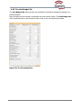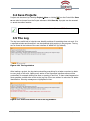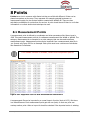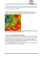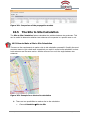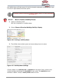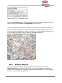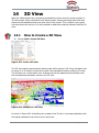
1
Release 6.1 - User Manual brown-iposs GmbH User Manual WiMAP-4G 6.1 Page 1 of 297 broadband wireless networks - investigations ● planning ● operations support systems Copyright brown-iposs GmbH 2015 Copyright at brown-iposs GmbH. All rights reserved. Translation, reprinting, copying of illustrations, broadcasting, photomechanical or similar reproduction always requires the permission by brown-iposs GmbH. Storage, also on data-processing systems, even of parts, is allowed only for documenting. As long as not otherwise indicated this document and all of its parts are confidential and might not be distributed to third parties. Label WiMAP-4G is a registered label of brown-iposs GmbH. brown-iposs GmbH User Manual WiMAP-4G 6.1 Page 2 of 297 broadband wireless networks - investigations ● planning ● operations support systems Contents ABOUT THIS MANUAL ................................................................................................................ 10 CONVENTIONS ....................................................................................................................................... 10 TECHNICAL ASSISTANCE.............................................................................................................. 11 1 INTRODUCTION ................................................................................................................... 12 1.1 WIMAP-4G .............................................................................................................................. 12 1.2 WIMAP-4G EDITIONS ................................................................................................................. 12 1.2.1 WiMAP-4G Community-Edition ....................................................................................... 12 1.2.2 WiMAP-4G Professional-Edition ...................................................................................... 13 1.3 SYSTEM REQUIREMENTS ............................................................................................................... 14 1.4 INSTALLATION ............................................................................................................................. 15 1.4.1 How to Install WiMAP-4G ................................................................................................ 15 1.5 LAUNCHING WIMAP-4G FOR THE FIRST TIME ................................................................................. 16 1.5.1 Get a License for the Professional-Edition ....................................................................... 17 1.5.2 Get a License for the Community-Edition ........................................................................ 17 1.6 GLOBAL SETTINGS ....................................................................................................................... 18 2 FIRST STEPS ......................................................................................................................... 23 2.1 THE FIRST PROJECT ...................................................................................................................... 23 2.2 WORK AREA ............................................................................................................................... 25 2.2.1 Work Area Basics ............................................................................................................. 25 2.2.2 Elements of the Control-Bar ............................................................................................ 26 2.2.3 The Rectangle Zoom Tool ................................................................................................ 28 2.2.4 The Distance/Measurement Tool .................................................................................... 29 2.2.5 The Terrain-Profiler .......................................................................................................... 30 2.2.5.1 2.2.5.2 2.2.5.3 2.2.5.4 How to Use the Terrain-Profiler ................................................................................................................ 30 Configuring the Terrain-Profiler ................................................................................................................ 32 Additional Terrain-Profiler Zoom ............................................................................................................... 35 Terrain-Profiler Export Features ................................................................................................................ 36 2.3 CUSTOMIZING THE WORK AREA..................................................................................................... 37 2.3.1 Transfix the Windows ...................................................................................................... 37 2.3.2 Adjustment and Zoom Customization ............................................................................. 38 2.4 THE PROJECT-EXPLORER ............................................................................................................... 39 2.4.1 The Sites Tab .................................................................................................................... 40 2.4.2 The Layers Tab ................................................................................................................. 40 2.4.3 The Points Tab ................................................................................................................. 42 2.4.4 The Calculation Tab ......................................................................................................... 43 2.4.5 The Elevation Model Tab ................................................................................................. 44 2.4.6 The Cadastral Data Tab ................................................................................................... 45 2.4.7 The Clients Tab................................................................................................................. 45 2.4.8 The Link Budget Tab ........................................................................................................ 46 3 PROJECTS ............................................................................................................................ 47 3.1 PROJECT SETTINGS....................................................................................................................... 47 brown-iposs GmbH User Manual WiMAP-4G 6.1 Page 3 of 297 broadband wireless networks - investigations ● planning ● operations support systems 3.1.1 3.1.2 General ............................................................................................................................ 47 Calculation ....................................................................................................................... 47 3.1.2.1 Themes ...................................................................................................................................................... 49 3.1.2.1.1 How to Change a Colour Profile ........................................................................................................... 50 3.1.2.1.2 How to Add a New Colour Profile ........................................................................................................ 51 3.1.2.2 Empirical Models ....................................................................................................................................... 52 3.1.2.2.1 Free Space Propagation ....................................................................................................................... 54 3.1.2.2.1.1 How to Add a New Frequency Dependent Parameter for Free Space Propagation ..................... 55 3.1.2.2.2 ITU-R P.1411-3 ..................................................................................................................................... 56 3.1.2.2.3 Erceg Model ......................................................................................................................................... 57 3.1.2.2.4 Visibility................................................................................................................................................ 58 3.1.2.2.4.1 How to Add a New Frequency Dependent Parameter for Building Intersection .......................... 59 3.1.2.3 CORLA (Raylauncher) ................................................................................................................................. 60 3.1.2.3.1 Algorithm ............................................................................................................................................. 61 3.1.2.3.2 Model Parameters ............................................................................................................................... 62 3.1.2.4 WinProp ..................................................................................................................................................... 63 3.1.3 3.1.4 3.1.5 Elevation Model ............................................................................................................... 63 DXF ................................................................................................................................... 64 Building Classes ............................................................................................................... 64 3.1.5.1 How to Add a Building or Wood Profile ..................................................................................................... 65 3.2 CREATE PROJECTS........................................................................................................................ 67 3.2.1 Create Preconfigured Projects ......................................................................................... 68 3.2.1.1 How to Create a Preconfigured Project ..................................................................................................... 69 3.2.1.1.1 How to Find Specific Geographic Coordinates with Google Maps™ .................................................... 72 3.2.2 Create Empty Projects...................................................................................................... 73 3.2.2.1 How to Create an Empty Project ............................................................................................................... 73 3.3 LOAD PROJECTS .......................................................................................................................... 74 3.4 SAVE PROJECTS .......................................................................................................................... 75 3.5 THE LOG .................................................................................................................................... 75 4 GEODATA ............................................................................................................................ 76 4.1 CADASTRAL DATA ........................................................................................................................ 76 4.1.1 How to Import Cadastral Data ........................................................................................ 76 4.1.2 DXF Settings ..................................................................................................................... 78 4.1.2.1 How to Edit Cadastral Data Layers............................................................................................................. 79 4.2 ELEVATION MODELS .................................................................................................................... 81 4.2.1 How to Import an Elevation Model.................................................................................. 81 4.2.2 How to Reload an Elevation Model from Web ................................................................ 82 4.3 BACKGROUND IMAGES ................................................................................................................. 83 4.3.1 How to Import a Background Image ............................................................................... 84 4.4 LOCATION IMAGES....................................................................................................................... 84 4.4.1 How to Import a Location Image/Images ........................................................................ 85 4.4.2 How to View a Location Image/Images ........................................................................... 87 4.4.3 How to Delete a Location Image/Images ........................................................................ 88 4.4.4 How to Import as Background Image .............................................................................. 89 5 BUILDINGS .......................................................................................................................... 91 5.1 CREATE BUILDINGS ...................................................................................................................... 92 5.1.1 How to Create Buildings .................................................................................................. 92 5.1.2 Advanced Buildings .......................................................................................................... 96 brown-iposs GmbH User Manual WiMAP-4G 6.1 Page 4 of 297 broadband wireless networks - investigations ● planning ● operations support systems 5.1.2.1 5.1.2.2 How to Create Courtyard or Similar in Buildings ....................................................................................... 96 How to Add Intersecting Buildings ............................................................................................................ 97 5.2 EDIT BUILDINGS .......................................................................................................................... 99 5.2.1 How to Edit a Building ..................................................................................................... 99 5.3 EXPORT BUILDINGS ...................................................................................................................... 99 5.3.1 How to Export Buildings ................................................................................................ 100 5.4 IMPORT BUILDINGS .................................................................................................................... 100 5.4.1 How to Import Buildings ................................................................................................ 100 5.5 CREATE BUILDINGS USING CADASTRAL DATA (PROFESSIONAL-EDITION) ............................................. 101 5.5.1 How to Create Buildings Using Cadastral Data ............................................................. 101 5.6 CREATE BUILDINGS USING CORINE (PROFESSIONAL-EDITION) ......................................................... 102 5.6.1 How to Create Buildings Using CORINE Data ................................................................ 102 5.7 DELETE BUILDINGS .................................................................................................................... 105 5.7.1 How to Delete Building manually .................................................................................. 105 5.8 CLEAR BUILDING CACHE ............................................................................................................. 105 5.8.1 How to Clear Building Cache.......................................................................................... 106 6 CARRIER .............................................................................................................................107 6.1 HOW TO CREATE OR EDIT CARRIER .............................................................................................. 108 6.2 IMPORT CARRIER ....................................................................................................................... 111 6.2.1 How to Import Carrier.................................................................................................... 111 7 SITES, RADIO UNITS AND ANTENNAS...................................................................................113 7.1 ANTENNAS ............................................................................................................................... 113 7.1.1 Create Antennas ............................................................................................................ 113 7.1.1.1 7.1.1.2 7.1.2 How to Create Antennas ......................................................................................................................... 113 How to Create Antenna Types ................................................................................................................. 115 Editing Antennas............................................................................................................ 118 7.1.2.1 7.1.2.2 7.1.3 7.1.4 7.1.5 7.1.6 How to Edit Antennas .............................................................................................................................. 118 How to Edit Antenna Types ..................................................................................................................... 120 How to Copy Antennas .................................................................................................. 121 How to Change all Antennas Faster .............................................................................. 122 How to Create a Pattern File ......................................................................................... 123 Export Antennas ............................................................................................................ 127 7.1.6.1 7.1.7 How to Export Antennas .......................................................................................................................... 127 Import Antennas ............................................................................................................ 127 7.1.7.1 7.1.7.2 7.1.8 How to Import Antennas ......................................................................................................................... 128 How to Import Antenna Types ................................................................................................................ 129 Activate or Deactivate Antennas ................................................................................... 130 7.1.8.1 7.1.8.2 7.1.8.3 7.1.9 7.1.10 How to Activate/Deactivate Antennas .................................................................................................... 130 How to Invert Activation.......................................................................................................................... 131 How to Activate Antennas by a Filter ...................................................................................................... 131 Invalid Antennas ............................................................................................................ 132 Distributed/MIMO Antennas ......................................................................................... 135 7.1.10.1 How to Create Distributed/MIMO Antennas ...................................................................................... 135 7.2 RADIO UNITS ............................................................................................................................ 137 7.2.1 How to Create a Radio Unit ........................................................................................... 138 7.2.2 How to Edit a Radio Unit ............................................................................................... 139 7.2.3 How to Copy a Radio Unit .............................................................................................. 140 brown-iposs GmbH User Manual WiMAP-4G 6.1 Page 5 of 297 broadband wireless networks - investigations ● planning ● operations support systems 7.2.4 7.2.5 7.2.6 How to Change Carrier in a Radio Unit .......................................................................... 142 How to Change Radio Units faster................................................................................. 144 Activate or Deactivate Radio Units ................................................................................ 144 7.2.6.1 7.2.6.2 7.2.6.3 How to Activate or Deactivate Radio Units at once ................................................................................. 145 How to Activate or Deactivate Radio Units manually .............................................................................. 145 How to Invert Activation.......................................................................................................................... 146 7.3 SITES ....................................................................................................................................... 146 7.3.1 How to Create Sites ....................................................................................................... 146 7.3.2 How to Edit Sites ............................................................................................................ 152 7.3.3 How to Copy Sites .......................................................................................................... 154 7.3.4 Activate or Deactivate Sites ........................................................................................... 156 7.3.4.1 7.3.4.2 How to Activate or Deactivate all Sites at Once ...................................................................................... 156 How to Activate or Deactivate Sites Manually ........................................................................................ 157 8 POINTS ...............................................................................................................................158 8.1 MEASUREMENT POINTS ............................................................................................................. 158 8.2 POINT CATEGORIES .................................................................................................................... 160 8.2.1 How to Edit Point Categories ......................................................................................... 161 8.2.2 How to Create a Point Category .................................................................................... 162 8.3 CREATE POINTS ......................................................................................................................... 164 8.3.1 How to Create Points ..................................................................................................... 164 8.3.2 How to Edit Single Points ............................................................................................... 166 8.3.3 How to Edit Multiple Points ........................................................................................... 167 8.4 POINT ACTIVATION .................................................................................................................... 168 8.4.1 How to Activate or Deactivate Points ............................................................................ 168 8.5 EXPORT AND IMPORT OF POINTS .................................................................................................. 169 8.5.1 How to Export Points as .csv file .................................................................................... 169 8.5.2 How to Export Points as .kml file ................................................................................... 170 8.5.3 How to Import Points ..................................................................................................... 171 8.6 POINTS COLOUR ASSIGNMENT ..................................................................................................... 172 8.6.1 How to Change the Colour of a Point manually ............................................................ 173 8.6.2 Change Colour of Points temporary by Visualisation tab .............................................. 173 8.6.3 Change Colour of Points by Coverage tab ..................................................................... 173 8.6.4 Change Colour of Points according to Theme Calculation ............................................. 174 8.7 CLIENTS AND POINTS.................................................................................................................. 174 8.7.1 How to Create Clients from Points ................................................................................. 175 8.7.2 How to Convert Clients to Points ................................................................................... 176 8.8 POINT PARAMETERS .................................................................................................................. 178 8.8.1 How to Assign carrier..................................................................................................... 178 9 CLIENTS ..............................................................................................................................179 9.1 CLIENT PROFILES ....................................................................................................................... 179 9.1.1 How to Create Client Profiles ......................................................................................... 179 9.1.2 How to Edit Client Profiles ............................................................................................. 181 9.2 CLIENT CREATION ...................................................................................................................... 182 9.2.1 How to Create Clients .................................................................................................... 182 9.3 EDIT CLIENTS ............................................................................................................................ 184 brown-iposs GmbH User Manual WiMAP-4G 6.1 Page 6 of 297 broadband wireless networks - investigations ● planning ● operations support systems 9.3.1 How to Edit Clients......................................................................................................... 184 9.4 ASSIGN CLIENTS TO SITES............................................................................................................ 186 9.4.1 How to Assign Clients to Sites ........................................................................................ 186 9.5 HOW TO USE THE TERRAIN-PROFILER FOR CLIENT TO SITE................................................................ 186 9.6 INVALID CLIENTS ....................................................................................................................... 187 10 CALCULATIONS AND THEMES ..........................................................................................188 10.1 CALCULATIONS AND THEME TYPES............................................................................................ 188 10.2 THE FIELD STRENGTH AREA CALCULATION ................................................................................. 189 10.2.1 How to Make a Field Strength Area Calculation............................................................ 189 10.2.1.1 10.2.1.2 10.2.1.3 10.2.1.4 10.2.1.5 10.2.1.6 With the Erceg Model ......................................................................................................................... 190 With the CORLA Raylauncher Model................................................................................................... 192 With the ITU-R P.1411-3 Model .......................................................................................................... 193 With the Free Space Propagation Model ............................................................................................ 194 With WinProp...................................................................................................................................... 195 General Settings .................................................................................................................................. 196 10.3 THE CLIENT COVERAGE CALCULATION ....................................................................................... 196 10.3.1 How to Make a Client Coverage Calculation ................................................................. 197 10.3.1.1 10.3.1.2 10.3.1.3 10.3.1.4 10.3.1.5 With the Erceg Model ......................................................................................................................... 198 With the CORLA Raylauncher Model................................................................................................... 200 With the ITU-R P.1411-3 Model .......................................................................................................... 201 With the Free Space Propagation Model ............................................................................................ 202 With WinProp...................................................................................................................................... 203 10.4 THE POINT FIELD STRENGTH CALCULATION ................................................................................ 204 10.4.1 How to Make a Point Field Strength Calculation ........................................................... 206 10.4.1.1 10.4.1.2 10.4.1.3 10.4.1.4 10.4.1.5 10.4.1.6 10.4.2 With the Erceg Model ......................................................................................................................... 207 With the CORLA Raylauncher Model................................................................................................... 209 With the ITU-R P.1411-3 Model .......................................................................................................... 211 With the Free Space Propagation Model ............................................................................................ 212 With WinProp...................................................................................................................................... 213 General Settings .................................................................................................................................. 214 Compare all Propagation Models .................................................................................. 214 10.4.2.1 How to Use all Propagation Models for a Point Field Strength Calculation ........................................ 214 10.5 THE SITE TO SITE CALCULATION................................................................................................ 217 10.5.1 How to Make a Site to Site Calculation ......................................................................... 217 10.6 THE COVERAGE THEME........................................................................................................... 219 10.6.1 How to Create a Coverage Theme ................................................................................. 220 10.7 THE BEST SERVER THEME ........................................................................................................ 223 10.7.1 How to Create a Best Server Theme .............................................................................. 223 10.8 THE CARRIER TO INTERFERER THEME ........................................................................................ 226 10.8.1 How to Create a Carrier to Interferer Theme................................................................. 227 10.9 THE POWER LEVEL THEME ...................................................................................................... 231 10.9.1 How to Create a Power Level Theme ............................................................................. 231 10.10 THE SUB-CARRIER INTERFERENCE THEME .................................................................................. 234 10.10.1 How to Create a Sub-Carrier Interference Theme ...................................................... 235 10.11 THE FIELD STRENGTH THEME ................................................................................................... 239 10.11.1 How to Create a Field Strength Theme ...................................................................... 239 10.12 THE ELEVATION THEME .......................................................................................................... 243 10.12.1 How to Create an Elevation Theme............................................................................ 244 brown-iposs GmbH User Manual WiMAP-4G 6.1 Page 7 of 297 broadband wireless networks - investigations ● planning ● operations support systems 10.13 THE VISIBILITY THEME ............................................................................................................ 245 10.13.1 How to Create a Visibility Theme ............................................................................... 246 10.13.1.1 How to Clear the Visibility Cache ........................................................................................................ 247 10.14 EXPORT CALCULATION THEME ................................................................................................. 248 10.14.1 How to Export a Theme.............................................................................................. 248 10.15 CLEAR AND DELETE CALCULATION ............................................................................................ 250 10.15.1 How to Clear the Calculation and Theme Layer ......................................................... 251 10.15.2 How to Delete the Calculation ................................................................................... 251 10.16 CALCULATION WITH DESIRED/MIMO ANTENNAS ....................................................................... 253 10.16.1 How to Create a Power Level Theme with Desired/MIMO Antennas ........................ 253 11 ISOLINES .........................................................................................................................255 11.1 THEME ISOLINES .................................................................................................................... 255 11.1.1 How to Create Theme Isolines ....................................................................................... 255 11.2 ELEVATION ISOLINES............................................................................................................... 257 11.2.1 How to Create Elevation Isolines ................................................................................... 257 11.3 ISOLINE EXPORT..................................................................................................................... 258 11.3.1 How to Export Isolines as MIF........................................................................................ 259 11.3.2 How to Export Isolines as KML ....................................................................................... 259 12 ADDITIONAL FUNCTIONS .................................................................................................261 12.1 SHOW ON GOOGLE MAPS™ .................................................................................................... 261 12.1.1 How to Use the function Show on Google Maps ........................................................... 261 12.2 ACTIVATION/DEACTIVATION .................................................................................................... 261 12.2.1 How to Activate und Deactivate Layers ......................................................................... 261 12.3 COLOUR ............................................................................................................................... 263 12.3.1 How to Make a Site coloured......................................................................................... 263 12.3.2 How to Make a Radio Unit coloured.............................................................................. 264 12.3.3 How to Make an Antenna coloured ............................................................................... 265 12.3.4 How to Make a Point coloured ...................................................................................... 265 13 LINK BUDGET ..................................................................................................................266 13.1 HOW TO MAKE A LINK BUDGET CALCULATION............................................................................ 267 13.1.1 Manually ........................................................................................................................ 268 13.1.2 Automatically by Using the Terrain-Profiler .................................................................. 268 14 3D VIEW..........................................................................................................................272 14.1 HOW TO CREATE A 3D VIEW ................................................................................................... 272 14.2 NAVIGATE THE 3D-VIEW ........................................................................................................ 273 14.2.1 Navigation Specials........................................................................................................ 274 14.3 EXPORT A 3D VIEW ................................................................................................................ 275 14.3.1 How to Export a 3D View ............................................................................................... 275 15 GLOSSARY .......................................................................................................................276 16 FAQ ................................................................................................................................281 16.1.1 What is WiMAP-4G? ...................................................................................................... 281 16.1.2 Does WiMAP-4G supports 64-bit operating systems?................................................... 281 16.1.3 Which languages does WiMAP-4G support? ................................................................. 281 16.1.4 Do I have to be online to use WiMAP-4G?..................................................................... 281 16.1.5 What file formats does WiMAP-4G support? ................................................................ 281 brown-iposs GmbH User Manual WiMAP-4G 6.1 Page 8 of 297 broadband wireless networks - investigations ● planning ● operations support systems 16.1.6 How much does WiMAP-4G cost? ................................................................................. 282 16.1.7 What is the difference between WiMAP-4G Editions? .................................................. 282 16.1.8 What are the requirements to get a license? ................................................................ 282 16.1.9 Can I upgrade my Community-Edition to Professional-Edition at a later date within the program?...................................................................................................................................... 282 16.1.10 Do I have to update my WiMAP-4G from time to time? ............................................ 282 17 TROUBLESHOOTING ........................................................................................................283 18 IMAGE DIRECTORY ..........................................................................................................287 brown-iposs GmbH User Manual WiMAP-4G 6.1 Page 9 of 297 broadband wireless networks - investigations ● planning ● operations support systems About this Manual This user manual describes the setup and operation of the WiMAP-4G software. The WiMAP4G user manual requires a basic understanding of the Windows operating system. If you are not familiar with this system, refer to the documentation provided by Microsoft. Newcomer of WiMAP-4G software should read Chapter 1 to learn about the program, requirements and installation Chapters 2 and 3 to learn about WiMAP-4G essentials Conventions Convention Notice Type Use Italic User actions Bold Marks user interface elements such as buttons, menus, label, tabs brown-iposs GmbH Caution Describes important features, instructions or limitations Tipp Highlights features or hints that can save time and prevent difficulties Step by Step Step by step explanation Info Additional information User Manual WiMAP-4G 6.1 Page 10 of 297 broadband wireless networks - investigations ● planning ● operations support systems Technical Assistance For technical questions or problem solving assistance, read the section which is related to your performing operation. If additional assistance is needed, contact the brown-iposs support. Have following information ready for the brown-iposs support to detect a problem: any error messages details of recent system performance WiMAP-4G version number (can be found under HelpInfo) operating system on your computer brown-iposs GmbH User Manual WiMAP-4G 6.1 Page 11 of 297 broadband wireless networks - investigations ● planning ● operations support systems 1 Introduction 1.1 WiMAP-4G WiMAP-4G is the radio network planning software by brown-iposs. It is developed particularly for planning the air interface of wireless broadband access networks, e.g. based on WiMAX and WLAN standard. Also other carriers are supported. The software is Javabased and able to run on every modern standard computer. WiMAP-4G is suitable for both, beginners as well as experienced users and offers sufficient possibilities to plan even the largest projects. Figure 1: The WiMAP-4G working interface 1.2 WiMAP-4G Editions Currently there are two different versions of WiMAP-4G available. The Professional-Edition offers additional features and supports more objects in the same project. 1.2.1 WiMAP-4G Community-Edition The WiMAP-4G Community-Edition is a free version, which contains most of the functionality, but with specific restrictions. Features of the Community-Edition: a configurable and clean interface brown-iposs GmbH User Manual WiMAP-4G 6.1 Page 12 of 297 broadband wireless networks - investigations ● planning ● operations support systems easy generation of new projects import of cadastral data import of elevation models lists buildings and wood provides a large number of different antennas constructing clients and points measurement points import of location images extensive calculation options many different themes a 3D view of the terrain the Terrain-Profiler to keep track of the area detailed calculations with the link budget isolines export of isolines propagation models o Erceg model (provides three different patterns or individual creation) o ITU-R P.1411-3 o Free Space Propagation The Community-Edition allows a maximum of 12 radio stations and 50 points of the same type within one project. Moreover, it is not possible to use the highest accuracy level for calculations. Some import and export functions are working in the Professional-Edition only. This version is a sample of the software which gives the user an opportunity to try it out without having to purchase a complete version. It is completely suitable for smaller projects. 1.2.2 WiMAP-4G Professional-Edition The WiMAP-4G Professional-Edition is the chargeable version of the program. It contains all functions of the WiMAP-4G Community-Edition including the following additional features: generates buildings and wood from cadastral data imports CORINE data provides calculations with the highest accuracy brown-iposs GmbH User Manual WiMAP-4G 6.1 Page 13 of 297 broadband wireless networks - investigations ● planning ● operations support systems CORLA-Raylauncher (Cube Oriented Ray Launching Algorithm) as an additional propagation model WinProp as an additional propagation model large selection of antenna patterns extended export formats The WiMAP-4G Professional-Edition offers high flexibility and delivers additional tools for planning carrier networks. Figure 2: The Professional-Edition offers CORLA as an additional propagation model. 1.3 System Requirements WiMAP-4G is a Java based software and therefore compatible with every windows operating system. 64-bit systems are supported, too. Minimum system requirements: Operating System: Windows XP/7/8 or similar (has to be windows) Computer Processor: Pentium III with at least 1 GHz or equivalent Computer Memory: 2048 MB or more Internet: connection is required to get a license file (Community-Edition) and to use OpenStreetMap™ Since WiMAP-4G is Java-based, other platforms may be supported on request. A 64-bit-Java-Runtime-Environment is included in WiMAP-4G. brown-iposs GmbH User Manual WiMAP-4G 6.1 Page 14 of 297 broadband wireless networks - investigations ● planning ● operations support systems 1.4 Installation On http://www.brown-iposs.com/en/wimap4g/download.php you will find all required installation files, a list of features and the WiMAP-4G software license agreement. The windows installer file WiMAP-4G Professional-/Community-Edition is required for installation. It is a zip file which needs to be unzipped before the installation. 1.4.1 How to Install WiMAP-4G 1. Unzip the downloaded WiMAP-4G-v6_1_0-setupNN.zip. (NN=32 or 64 according to your choice) 2. Start installation by double-clicking the extracted setup.exe. Figure 3: Installation has been started 3. Choose installation directory. Figure 4: Installation directory brown-iposs GmbH User Manual WiMAP-4G 6.1 Page 15 of 297 broadband wireless networks - investigations ● planning ● operations support systems Figure 5: Start menu folder selection 4. Select program icon locations. Figure 6: Program icon location 5. Click Next to start installation. 1.5 Launching WiMAP-4G for the First Time After the installation is completed successfully, the program can be started for the first time. brown-iposs GmbH User Manual WiMAP-4G 6.1 Page 16 of 297 broadband wireless networks - investigations ● planning ● operations support systems Figure 7: License agreement WiMAP-4G needs a license to run. There are licenses for Community-Edition and Professional-Edition. For using the Community-Edition, a name and a valid e-mail address are sufficient. A license file is send by e-mail and is available immediately. 1.5.1 Get a License for the Professional-Edition A license for the Professional-Edition can be purchased later. To run the Professional-Edition an USB-Dongle is needed, which is provided by brown-iposs. 1.5.2 Get a License for the Community-Edition Figure 8: Program edition/License request After completing the required fields with valid information, an e-mail will be sent to the named e-mail address. This license file is required so it is ought to be downloaded first. brown-iposs GmbH User Manual WiMAP-4G 6.1 Page 17 of 297 broadband wireless networks - investigations ● planning ● operations support systems After downloading the file it can be selected by clicking Choose and entering the correct file path. If this is a valid license file, WiMAP-4G will start for the first time. Figure 9: Choose location of your license file If there are any problems, try to find a solution in the FAQ at the end of the user manual first. 1.6Global Settings Here you can specify the global settings for WiMAP-4G. These settings effect on the whole program, not only on your individual project. Therefore check chapter 3.1 in this manual. Go to Extras -> Global Settings. Figure 10: Global Settings The following settings can be made: Startup WiMAP-4G offers you by default a welcome screen where you can select to create a new project, open a previously saved one or use a sample project. In this menu it can be defined how WiMAP-4G shall behave on startup and how many recent projects shall be shown in the list. brown-iposs GmbH User Manual WiMAP-4G 6.1 Page 18 of 297 broadband wireless networks - investigations ● planning ● operations support systems Figure 11: Startup menu Database WiMAP-4G uses a default database file for every project, but you can select your own database file instead. In addition you can choose to load Carriers, Antenna Types and Point Categories. Figure 12: Database menu Plot When you select Intelligent Label Arrangement the label will be arranged so that there is no overlapping of text. You can also specify to draw objects always in black or grey (this overrides the detailed colour settings for antennas or buildings). brown-iposs GmbH User Manual WiMAP-4G 6.1 Page 19 of 297 broadband wireless networks - investigations ● planning ● operations support systems For explanation of Translation Factor and Zoom Factor see chapter 2.3.2. Figure 13: Plot menu Plot -> Export Here you can select which information shall be shown when you plot your project. Figure 14: Plot -> Export menu brown-iposs GmbH User Manual WiMAP-4G 6.1 Page 20 of 297 broadband wireless networks - investigations ● planning ● operations support systems Units The calculation units for Field Strength, Power Level, Power Rate and Data Rate can be set here. Figure 15: Units menu These settings will only effect after restarting WiMAP-4G. Check for New Version When starting up WiMAP-4G it will be checked whether a new version is available. Here you can enable to use a proxy server for the internet connection, depending on your system configuration. brown-iposs GmbH User Manual WiMAP-4G 6.1 Page 21 of 297 broadband wireless networks - investigations ● planning ● operations support systems Figure 16: Check for New Version menu brown-iposs GmbH User Manual WiMAP-4G 6.1 Page 22 of 297 broadband wireless networks - investigations ● planning ● operations support systems 2 First Steps 2.1 The First Project After installation and activation are successfully completed the program launches and a new project can be created. Figure 17: WiMAP-4G launches for the first time After launching WiMAP-4G for the first time there are three possibilities: Create a new project. Load a project from a .rad file. Have a look at the demo project "Munich". Newcomers should take a look at the demo project to get an impression of the program and its possibilities. brown-iposs GmbH User Manual WiMAP-4G 6.1 Page 23 of 297 broadband wireless networks - investigations ● planning ● operations support systems Figure 18: Demo project "Munich" The demo project is a complete project including sites, different carriers and an elevation model. The Terrain-Profiler can be tested as well as different propagation models. brown-iposs GmbH User Manual WiMAP-4G 6.1 Page 24 of 297 broadband wireless networks - investigations ● planning ● operations support systems 2.2 Work Area WiMAP-4G is clearly arranged to make work easier for experienced users and even for newcomers. 2.2.1 Work Area Basics Control-Bar Project-Explorer Terrain-Explorer Terrain-Profiler At the Project-Explorer, different views can be chosen. Cursor-Point Figure 19: Graphical user interface/work area Almost all functions can be reached within one or two mouse clicks. The Project-Explorer is on the right side and offers the following views: Sites Layers Points Calculation Elevation models Cadastral data brown-iposs GmbH User Manual WiMAP-4G 6.1 Page 25 of 297 broadband wireless networks - investigations ● planning ● operations support systems Clients Link Budget calculation The view can be changed at every time. At the bottom of the screen the Terrain-Profiler can be found as well as the log and cursor windows. Access the control-bar below the menu bar. The control-bar enables a boundless moving around the terrain, including buttons for all essential functions. 2.2.2 Elements of the Control-Bar Create a new project. An open project can be saved or discarded. Load a project from a .rad file. An open project can be saved or discarded. Save the current project. One step back. This function affects only changes on the work area. Calculations and object actions cannot be reverted. One step forward. This function affects only changes on the work area. Calculations and object actions cannot be reverted. Shift the visible area to west. Shift the visible area to north. Shift the visible area to east. Shift the visible area to south. Shift the area to center the cursor. brown-iposs GmbH User Manual WiMAP-4G 6.1 Page 26 of 297 broadband wireless networks - investigations ● planning ● operations support systems Scale up the visible area. Options can be found at ExtrasGlobal SettingsPlot Scale down the visible area. Options can be found at ExtrasGlobal SettingsPlot Optimal adjustment of the visible area. Scales up or down and shift to put all objects to the plot. Centers up the selected object. While activated, objects chosen from the Project-Explorer become centered on the screen. The rectangle-zoom tool. The distance/measurement tool. Simply changes object positions with the drag and drop function. Activates the Terrain-Profiler. Opens the field strength area calculation. Now the field strength can be calculated with different propagation models. Export the plot with components to file or to clipboard This function can be enabled or disabled. Only one of these functions can be enabled at a time. Furthermore, any essential function can be found in the submenus. Detailed explanations can be found in the following chapters. The bulk of the screen is filled with the TerrainExplorer. As mentioned, there are four functions run by the left mouse button: rectangle zoom distance/measurement tool Terrain-Profiler brown-iposs GmbH User Manual WiMAP-4G 6.1 Page 27 of 297 broadband wireless networks - investigations ● planning ● operations support systems drag and drop function For shifting the terrain around without using the arrow buttons in the control bar, push and hold the right mouse button. The blue frame inside the Terrain-Explorer shows the maximum area for calculating a propagation model. This blue frame compiles while creating a new project and cannot be changed subsequently. Originally the propagation models are calculated for the actual image selection. So it is advisable to choose a larger area for this frame than necessary. The cursor can be set to a specific point by clicking the left mouse button. This can be instrumental in preventing the user from losing track on large projects. Use the function to mark a point for easily returning the cursor to at any time or insert coordinates by Cursor Point and click on Adjust to center the map by this coordinates. Figure 20: Cursor Point 2.2.3 The Rectangle Zoom Tool The rectangle zoom tool is a useful feature of WiMAP-4G to zoom into the right area on the map. Just click on the button on the control bar to activate the rectangle zoom. Choose a point on the map, hold the left mouse button and drag the cursor to mark the exact area. brown-iposs GmbH User Manual WiMAP-4G 6.1 Page 28 of 297 broadband wireless networks - investigations ● planning ● operations support systems Figure 21: Rectangle Zoom Figure 22: Mark an area The rectangle zoom tool can also be activated by choosing ToolsRectangle Zoom. 2.2.4 The Distance/Measurement Tool The distance/measurement tool is useful to get a distance or a specific angle of the map. Click the button on the control bar to activate the distance/measurement tool. Choose and click on a desired point on the map with the left mouse button, hold the button and drag the cursor to the desired position. See the distance and angle difference beside the line that connects the start and target point. brown-iposs GmbH User Manual WiMAP-4G 6.1 Page 29 of 297 broadband wireless networks - investigations ● planning ● operations support systems Figure 23: Distance/measurement tool The distance/measurement tool can also be activated by choosing ToolsDistance/Angle Measurement. 2.2.5 The Terrain-Profiler The Terrain-Profiler is a powerful feature which allows the user to take a snapshot of the environment and watch out for obstacles like mountains or buildings which could interrupt the signal of antennas or disrupt intervisibility. The Terrain-Profiler consists of two parts, the tool itself that can be used to drag around the map and watch out for obstacles and the Terrain-Profiler tab which shows the territory inside the dragged zone. The Terrain-Profiler basically works similar to the distance measurement tool, except the additional tab that shows the territory. 2.2.5.1 How to Use the Terrain-Profiler 1. Click on the button on the control bar to activate the Terrain-Profiler tool. Click on a desired point on the map, hold the left mouse button and drag the cursor to the desired position. See the distance and angle difference beside the line that connects the start and target point. brown-iposs GmbH User Manual WiMAP-4G 6.1 Page 30 of 297 broadband wireless networks - investigations ● planning ● operations support systems Figure 24: The Terrain-Profiler looks like the distance/measurement tool. 2. For additional information look in the Terrain-Profiler tab which is at the bottom of the WiMAP-4G window by default. The graph in Figure 25 shows how the TerrainProfiler projects the territory into the Terrain-Profiler tab. Figure 25: The Terrain-Profiler tab On the right side of the Terrain-Profiler tab is a legend that shows all relevant information: elevation, buildings, the Fresnel Zone and the pathloss. The circle will automatically change its colour to red if there is any disruption in the Fresnel Zone. This will help the user to see automatically if the desired path is possible or not. Figure 26: The Fresnel Zone is interrupted. brown-iposs GmbH User Manual WiMAP-4G 6.1 Page 31 of 297 broadband wireless networks - investigations ● planning ● operations support systems 2.2.5.2 Configuring the Terrain-Profiler The Terrain-Profiler offers a few settings which can be changed to get a better overview and to make the result descriptive for presentations. Click on the right mouse button to open a menu that contains the function Properties. A click on that button will open the property configuration window. Figure 27: The Terrain-Profiler configuration menu A figure can be named in the title tab. This could be useful for presentation or further information if the results of the Terrain-Profiler are exported. Activate shows the title. Enter the desired title in the Text field. To choose a font, click on Select next to the font field and choose the desired text font, the text size and a format. Click on OK to save the alterations. Figure 28: Change title, font and colour Click on Plot tab to make some additional configurations. brown-iposs GmbH User Manual WiMAP-4G 6.1 Page 32 of 297 broadband wireless networks - investigations ● planning ● operations support systems Figure 29: The plot menu The Plot tab contains all settings according to the axes. Change the label text by editing the label field. Font and text colour can also be changed within the tab. There are some additional settings provided at the bottom of the window. Tick labels can be enabled or disabled. Figure 30: Disabled tick labels Figure 31: Enabled tick labels Tick label marks can also be enabled or disabled. Figure 32: Enabled tick marks Figure 33: Disabled tick marks brown-iposs GmbH User Manual WiMAP-4G 6.1 Page 33 of 297 broadband wireless networks - investigations ● planning ● operations support systems In the range tab at the bottom of the window, the range value can be modified. If there are no specific circumstances, auto adjust range should be activated. Figure 34: The range tab All these settings also work for the range axis. At last, there is the appearance tab which contains settings to change the layout of the Terrain-Profiler. Figure 35: The appearance tab The outline stroke defines the thickness of the outline. For changing the colour of the outline click on the Select button next to the Outline paint row and choose a desired colour. The background paint defines the background colour of the plot itself. Preferably pick a neutral colour like white in order to not interfere the overview. The orientation of the plot can also be changed to vertical or horizontal. The other tab offers the following additional settings: Figure 36: The other tab brown-iposs GmbH User Manual WiMAP-4G 6.1 Page 34 of 297 broadband wireless networks - investigations ● planning ● operations support systems Anti-aliasing can be activated or deactivated. If there are no specific circumstances, antialiasing should always be enabled. Figure 37: Anti-aliasing enabled Figure 38: Anti-aliasing disabled The background paint defines the colour of the Terrain-Profiler, not the colour of the plot. Figure 39: A configured Terrain-Profiler tab 2.2.5.3 Additional Terrain-Profiler Zoom The Terrain-Profiler offers some additional functions for better analysis. Both axes can be zoomed in/out independently. A right mouse click on the Terrain-Profiler tab opens the menu that contains all zoom functions. brown-iposs GmbH User Manual WiMAP-4G 6.1 Page 35 of 297 broadband wireless networks - investigations ● planning ● operations support systems Figure 40: Terrain-Profiler zoom functions Each zoom submenu contains these three possibilities: both axes: zooms in/out the full image considering the x/y-ratio domain axis: zooms in/out the y-axis range axis: zooms in/out the x-axis The auto range submenu assures that all content of the marked terrain segment is shown. 2.2.5.4 Terrain-Profiler Export Features Export functions are available for the Terrain-Profiler, too. Results can be printed or exported for other applications or presentations. A right mouse click on the Terrain-Profiler tab opens the menu window containing the possibilities to Print or Save the Terrain-Profiler results: Figure 41: A plot can be saved or printed. By clicking on Print, the printer window opens: Figure 42: The printer window brown-iposs GmbH User Manual WiMAP-4G 6.1 Page 36 of 297 broadband wireless networks - investigations ● planning ● operations support systems Depending on the installed Java version, the window can have different looks, but settings are the same. After choosing the desired settings, a click on OK opens the printer menu. Printing can be started. Another way to export the Terrain-Profiler results is the Save as option which allows the user to store the plot as an image file on his hard drive. Figure 43: The plot can be saved as a .png-file. After choosing the file path and file name, click on Save to store the Terrain-Profiler results in a .png file. 2.3 Customizing the Work Area There are settings in WiMAP-4G that make work easier. These settings will be explained in this section. Generally WiMAP-4G is designed for working on a large screen. If that is not the case or the user works on a screen with a low resolution, it is necessary to customize the program. 2.3.1 Transfix the Windows The Project-Explorer, the Terrain-Profiler and also the log and cursor window can be transfixed by clicking on . When windows are transfixed, they only expand getting focused by the mouse cursor. This option can be reverted by only one mouse click on or choosing WindowReset Layout to reset all windows. The window size can also be changed by simply holding the left mouse button on a border of a window to drag it to the desired size. brown-iposs GmbH User Manual WiMAP-4G 6.1 Page 37 of 297 broadband wireless networks - investigations ● planning ● operations support systems Figure 44: Transfixing the windows results in a much bigger work area 2.3.2 Adjustment and Zoom Customization More settings can be found in ExtrasGlobal Settings. The following settings can be set up in the submenu Plot. Translation factor: This setting is essential for the four arrows in the control bar. The translation factor gives information about how far the map is shifted by using these arrowbuttons. A 1 means the whole map is shifted by an entire size of the screen. A 0.1 means the map is shifted by 10 % of the size of the screen. Boundary: 0.1 – 10 Zoom factor: The zoom factor option is important for the two zoom button in the control bar. It shows how much the map is up- or downscaled. A 1 simply means that the map is zoomed in by factor one, so nothing will happen with a 1. Values between 0.1 and 0.9 invert the zoom functions so that the scale up button scales down for example. With a 1.1 the entire map scales up or down by 10 %. Boundary: 0.1 - 10 Below, the labels can be configured to show objects and/or antennas coloured black and buildings gray. There is also an option for the intelligent label arrangement which gives the program the privilege to ignore the label standards if necessary. The size of pixel and labels can be changed in the submenu medium. Label size can be changed between 0.5 and 30 mm variably. The pixel size should only be changed if presentation errors occur. It is possible to change position and visibility of the legend in the submenu Legend. brown-iposs GmbH User Manual WiMAP-4G 6.1 Page 38 of 297 broadband wireless networks - investigations ● planning ● operations support systems 2.4 The Project-Explorer The Project-Explorer combines every object used in the actual project for a quite good overview. Each created, edited or imported case can be found in the Project-Explorer for detailed actions. Figure 45: The Project-Explorer The following tabs can be found in the Project-Explorer: Sites Layers Points Calculation Elevation model Cadastral data Clients Link budget calculation Every tab is designed individually to offer a good orientation and to keep all actions as simple as possible. brown-iposs GmbH User Manual WiMAP-4G 6.1 Page 39 of 297 broadband wireless networks - investigations ● planning ● operations support systems 2.4.1 The Sites Tab The Sites tab in the Project-Explorer gives an overview of all sites, radio units and antennas used in the project. Figure 46: The Sites tab The upper part of the Sites tab shows all sites used in the project. If you right click on one element in the upper part site, radio unit or antenna offers a few options for creation, deletion, activation, change multiple etc. More information can be found in the corresponding chapter in this manual. The lower part of the Sites tab shows all the antennas used in the project with their corresponding sites, radio unit and used carriers. If a site, radio unit or antenna is chosen in the upper part, the matching antenna(s) in the lower part are marked. Sites and antennas can be activated or deactivated just by checking or unchecking the boxes beside the desired antenna, radio unit or site. A deactivated antenna does not appear neither in a calculation nor on the map. 2.4.2 The Layers Tab The important thing to understand while working with WiMAP-4G: All things managed by the program are organized in layers and can be deactivated or activated as desired. Layers will brown-iposs GmbH User Manual WiMAP-4G 6.1 Page 40 of 297 broadband wireless networks - investigations ● planning ● operations support systems be created in WiMAP-4G for every single case created or edited by program: buildings, calculations, elevation, sites, clients, points etc. In the Project-Explorer of the Layers tab, all layers are listed. Figure 47: The Layers tab In Figure 47 you can see the Layers tab in the Project-Explorer, where everything is activated except debug and building heights. To deactivate a layer simply uncheck the box next to the layer name. Layers will be created automatically while performing actions such as calculations or building creation. The layers given in this example are the standard layers preconfigured for every project. Not all of them are used while creating a new project. Figure 48: Buildings layer enabled and disabled brown-iposs GmbH User Manual WiMAP-4G 6.1 Page 41 of 297 broadband wireless networks - investigations ● planning ● operations support systems 2.4.3 The Points Tab The Points tab has three subtabs: List, Coverage and Visualisation. The List tab shows all points used in the project sorted by the point category. Points can be activated or deactivated. If the used points are not listed in the Points tab, make sure to choose the correct point category. Figure 49: All used points will be shown in a list. A right click on a point offers the possibilities to create, edit, or delete a point. The little icons in the right upper corner allow export and calculation of the points and gives the possibility to edit the point classes. More information can be found in the corresponding chapter in this manual. The Coverage tab is for showing the colour of coverage levels based on the colour diagram of the carrier. brown-iposs GmbH User Manual WiMAP-4G 6.1 Page 42 of 297 broadband wireless networks - investigations ● planning ● operations support systems Figure 50: The Points tab – Coverage The Visualisation tab is for colouring points based on the category, the parameter that is visualised and the colouring which are shown in a table by Intervals. With one click on Adjust the colour is set. With Reset colour settings are restored back to the latter colouring. Figure 51: The Points tab – Visualisation 2.4.4 The Calculation Tab The Calculation tab is one of the most important tabs and shows all done calculation in the actual project. If a calculation is done, all sites and antennas used in this calculation will be shown in the Calculation tab. Single sites or antennas can be activated or deactivated for getting better brown-iposs GmbH User Manual WiMAP-4G 6.1 Page 43 of 297 broadband wireless networks - investigations ● planning ● operations support systems calculation results or even finding an interfering one. The upper part of the calculation tab offers all important calculations that are possible with WiMAP-4G. Right click on sites, radio unit or antennas offers many features described in corresponding chapters of this manual. Figure 52: The Calculation tab 2.4.5 The Elevation Model Tab The Elevation Model tab shows all elevation data that is used in the actual project. The elevation model file name and the file path are shown. A right click on an elevation model file offers the possibility to unload the file. More information about elevation models, elevation model import and editing elevation models can be found in the corresponding chapters of this manual. Figure 53: The Elevation Model tab brown-iposs GmbH User Manual WiMAP-4G 6.1 Page 44 of 297 broadband wireless networks - investigations ● planning ● operations support systems 2.4.6 The Cadastral Data Tab The Cadastral Data tab shows all the cadastral data which is used in the actual project. The cadastral data file name and the file path are shown. A right click on a cadastral data file offers the possibility to unload this file. More information about cadastral data and cadastral data import can be found in the corresponding chapters of this manual. Figure 54: The Cadastral Data tab 2.4.7 The Clients Tab The Clients tab shows all created clients in the actual project with their corresponding profile, height, coverage, power level, and carrier to interfere values. A right click on a client offers all the possibilities to create, edit or delete the client and to choose the Terrain-Explorer to show the environment between the client and his corresponding site. More information about clients and associated possible actions can be found in the corresponding chapters of this manual. Figure 55: The Clients tab brown-iposs GmbH User Manual WiMAP-4G 6.1 Page 45 of 297 broadband wireless networks - investigations ● planning ● operations support systems 2.4.8 The Link Budget Tab The Link Budget tab offers the user the possibility to calculate a detailed link budget for a desired situation. Many variables can be inserted to guarantee the most precise results. The Link Budget tab will be explained later in this manual so take a look on the corresponding chapters. Figure 56: The Link Budget tab brown-iposs GmbH User Manual WiMAP-4G 6.1 Page 46 of 297 broadband wireless networks - investigations ● planning ● operations support systems 3 Projects 3.1 Project Settings Before creating a new project, some adjustments should be done. Extensive adjustments can be made in ProjectProperties and ExtrasProject Defaults. The properties refer to the actual project in case it is already open. Project defaults are pre-configured settings. It is easier to use those than configure every single project individually. However the layout is the same for both. 3.1.1 General The following coordinate system types can be chosen: UTM (Universal Transverse Mercator) Gauss-Krueger Geographic By choosing UTM or Gauss-Krueger a start zone/stripe from the coordinate system can be selected. The earth is scaled in 60 stripes, Germany stands in stripe 32 for example. The cursor is placed on the chosen zone at equator level. The coordinate system type can also be chosen while creating a new project. Figure 57: The General Settings tab 3.1.2 Calculation In the Calculation tab it is possible to choose a default propagation model. The default setting is the Erceg Model. These propagation models can also be chosen while calculating. The Maximum and Minimum Antenna Area can be changed if necessary. brown-iposs GmbH User Manual WiMAP-4G 6.1 Page 47 of 297 broadband wireless networks - investigations ● planning ● operations support systems A license file is needed to use CORLA. This license is limited to a project and can be ordered at WIMAP-4G product support ([email protected]). The elevation theme provides bilinear interpolation or nearest neighbour. The elevation model can also be chosen during a calculation. Nearest neighbour: Nearest neighbour is an imprecise algorithm. It takes the height of the nearest point which got a value in the elevation model. Bilinear interpolation: This algorithm is more precise. It considers the closest four neighbours and calculates the average value of their height. That is why it is recommended even if it needs a little bit more processing time (which should not be registered on actual computer systems). Figure 58: Bilinear interpolation Figure 59: Nearest neighbour brown-iposs GmbH User Manual WiMAP-4G 6.1 Page 48 of 297 broadband wireless networks - investigations ● planning ● operations support systems Figure 60: The Calculation Settings tab 3.1.2.1 Themes The Theme tab contains all colour settings of the program. Some improvements should be done if larger projects shall be planned. Default settings are preset for every theme. For large projects additional colours should be added as well as some presets for different locations. Theme settings should always be made in Project Defaults to keep them saved for future projects. Colour profiles can be changed for Best Server Field Strength Power Level Sub Carrier Interference Carrier to Interferer (C/I) Elevation Visibility Ec/IO brown-iposs GmbH User Manual WiMAP-4G 6.1 Page 49 of 297 broadband wireless networks - investigations ● planning ● operations support systems Figure 61: The Theme Settings tab 3.1.2.1.1 How to Change a Colour Profile 1. Open Extras->Project Defaults->Calculation->Theme. Figure 62: Selecting a theme 2. Select the desired theme, for example Field Strength. Figure 63: Selecting the desired theme 3. Press Edit to open the configuration window. Now there are different possibilities to change a colour profile: Renaming profiles, changing transparency or adding new intervals are possible. Colour From and Colour To are the colours shown beyond the intervals. brown-iposs GmbH User Manual WiMAP-4G 6.1 Page 50 of 297 broadband wireless networks - investigations ● planning ● operations support systems Figure 64: A changed profile 4. Click on OK to save the changes. 3.1.2.1.2 How to Add a New Colour Profile 1. Open Extras->Project Defaults->Calculation->Theme Figure 65: Selecting a theme 2. Select the desired theme, for example Field Strength. 3. Press New to open the configuration window. Figure 66: Click on New 4. Name the new profile and change colour. (These are the colours shown beyond the intervals.) 5. Add intervals by selecting Add. brown-iposs GmbH User Manual WiMAP-4G 6.1 Page 51 of 297 broadband wireless networks - investigations ● planning ● operations support systems Figure 67: Click Add to add new intervals 6. Fill the required fields (From, To). Figure 68: Fill in all fields 7. Choose colours. 8. Name the interval if desired. 9. After adding all desired intervals, press OK. 10. Choose a profile for your project. Figure 69: The created profile appears in the list. All settings can be reset at the bottom by clicking Reset To Defaults. 3.1.2.2 Empirical Models Empirical models are used for propagation calculation. The resolution is preconfigured or can be configured manually for new projects. The resolution can be calculated absolutely brown-iposs GmbH User Manual WiMAP-4G 6.1 Page 52 of 297 broadband wireless networks - investigations ● planning ● operations support systems (in m) or relatively (in %). A resolution can also be chosen during a propagation calculation. The WiMAP-4G Community-Edition only allows an absolute value of 50 m. The Professional-Edition allows also resolutions up to centimeters. Furthermore, the attenuation interpolation can be changed, too. The standard setting is the bilinear interpolation. It should be the proper setting in general. Other interpolation models should only be chosen if necessary. Bilinear interpolation: A precise algorithm that considers the closest four neighbours and calculates the average value of their heights. Nearer of both: Considers the nearest neighbour and carries its value. Maximum of both: Considers the closest neighbour with the highest value (best case). Minimum of both: Considers the closest neighbour with the lowest value (worst case). The Pathloss Storage Precision can be changed to one, two, and four bytes. One byte should only be chosen if there is a large project to plan and only obsolete hardware can be used. There could be an aberration up to half a dB if 1 Byte is chosen for pathloss. 4 Byte is very precise but it could take a long time to calculate large projects. With current hardware 4 Byte is fine. Figure 70: The Empirical Models Settings tab brown-iposs GmbH User Manual WiMAP-4G 6.1 Page 53 of 297 broadband wireless networks - investigations ● planning ● operations support systems 3.1.2.2.1 Free Space Propagation The Free Space Propagation is a simple but effective propagation model. It is also called equation of radio wave propagation or Friss Model. The free space propagation model is primarily based on the elevation model. Optionally it takes into account visibility restrictions regarding the elevation model and the building model. While this model is not eligible for city centers and strongly cultured regions, it produces good results for suburban and rural regions, plus it is a very fast algorithm. It can help to identify critical regions where detailed measurements need to be done. Figure 71: The Free Space Propagation Settings tab There are two possibilities to calculate the path loss: Power Law (Lee's model) o Calculates the path loss with the power law. To use this option a path loss exponent is required. The path loss exponent comes in 1.6 to 6 depending on the terrain conditions. Terrain-Type Free space Plain surface City City with shadowing effects Buildings with line of sight Buildings without line of sight Table 1: Path loss exponent Path loss exponent 2 4 2.7 – 3.5 3–5 1.6 – 1.8 4-6 Exponential Law brown-iposs GmbH User Manual WiMAP-4G 6.1 Page 54 of 297 broadband wireless networks - investigations ● planning ● operations support systems o Calculates the path loss with the exponential law. To use this option a path loss factor is required. The standard path loss should only be changed by experienced users. The Elevation Model Attenuation can be set to a specific value to take account of obstacles like buildings and mountains or other line of sight interference. The value depends on the structure and its physical conditions. With the help of frequency dependent parameters it is possible to create profiles for every frequency in separate. Building intersection can be included in calculations at the bottom. It influences the calculation of a project in city areas and considers the fact that structures could stand in line. 3.1.2.2.1.1 How to Add a New Frequency Dependent Parameter for Free Space Propagation 1. Open Extras->Project Defaults->Calculation->Empirical Models->Free Space Propagation Figure 72: Choose free space propagation model 2. At the bottom of the window click Add. Figure 73: Click Add to add new parameters 3. Choose a Maximum Frequency for the profile. 4. Enter a Pathloss Exponent and a Pathloss Factor and press OK. Specific Pathloss Exponents can be found at 3.1.2.2.1. The Pathloss Factor should be 0.00230 for free space propagation. Figure 74: Pathloss exponents and factor brown-iposs GmbH User Manual WiMAP-4G 6.1 Page 55 of 297 broadband wireless networks - investigations ● planning ● operations support systems 3.1.2.2.2 ITU-R P.1411-3 ITU-R P.1411-3 is a semi-empirical model based on COST 231 Walfish-Ikegami and enhanced by ITU-R. The model considers detailed input data like average height and separation of buildings, street data (width, direction), BS and MS antenna height, length of the path covered by buildings as well as distance from BS to MS. Figure 75: The ITU-R P.1411-3 settings tab The ITU-R P.1411-3 settings offer a few settings according to the environment: Maximum height of buildings o Widths of roads o The building separation describes gap distance between buildings. It is expressed in meters. Road orientation o The width of roads can vary in different cities or villages. It is expressed in meters. Building separation o This height is only used if there is no elevation model that can be used for calculations. Basically, calculation is more detailed and offers precise results with elevation models. The road orientation describes the angle between crossing roads. It is expressed in degrees. Frequency Loss Factor o brown-iposs GmbH There is the frequency loss factor that should be either 0.7 or 1.5 according to the environment. 0.7 is used for medium sized city centers whereas 1.5 is used for metropolitan city centers. User Manual WiMAP-4G 6.1 Page 56 of 297 broadband wireless networks - investigations ● planning ● operations support systems 3.1.2.2.3 Erceg Model The IEEE 802.16.3c proposes this model developed by Victor Erceg for WiMAX planning. It is designed for suburban and urban areas and considers three Non-Line-of-Sight (NLoS)scenarios A, B and C: Terrain type A is a hilly terrain with moderate to heavy tree density and is associated with the highest path loss. Terrain type B is characterised as a mostly flat terrain with moderate to heavy tree density or a hilly terrain with light tree density. Terrain type C is a flat terrain with light tree density, producing the lowest path loss. Figure 76: The Erceg Model Settings tab First of all the decision can be made, which Erceg model should be used by default. If there are only a few trees there is no need to use type A by default, in that case Type C would be the right decision. Furthermore the coverage probability can be set to a specific value. This probability identifies the chance that gives the customer a specified link quality. At the bottom all the parameters can be changed for each Erceg model. Changing the parameters from Erceg A, B and C should only be done by experienced users. All other users could get some experience in changing the custom model. These three parameters for the path loss exponent, which is variable over the population of macro cells within each terrain category should only be changed for extreme terrain conditions. brown-iposs GmbH User Manual WiMAP-4G 6.1 Page 57 of 297 broadband wireless networks - investigations ● planning ● operations support systems Antenna-Term Factor: Sigma-Gamma: Sigma-Mu: Data derived constant for each terrain type Sigma-Sigma: Only experienced users should change these. 3.1.2.2.4 Visibility Some visibility settings can be changed according to the elevation theme and building intersection. First of all it is possible to change the Elevation Model Visibility type. The types, Bilinear Stepwise or Bilinear Cellwise, can be chosen. Figure 77: Elevation model visibility The next settings concentrate on the Building Intersection. These settings would be important if the project was planned in areas with a lot of buildings like city centres. First thing to decide is the Maximum Building Count for the building intersection. This parameter depends on the Maximum Attenuation per Building and the Maximum Overall Attenuation. The maximum building count multiplied with the maximum attenuation per building should not be higher than the maximum overall attenuation. This feature should only be used if the maximum attenuation per building is known. For the advanced user it is also possible to add Frequency Dependent Parameters. If the attenuation is well-known, frequency dependent parameters can help a lot in getting results close to reality. brown-iposs GmbH User Manual WiMAP-4G 6.1 Page 58 of 297 broadband wireless networks - investigations ● planning ● operations support systems 3.1.2.2.4.1 How to Add a New Frequency Dependent Parameter for Building Intersection 1. Open Extras->Project Defaults->Calculation->Empirical Models->Visibility Figure 78: Visibility of empirical models 2. At the bottom part of the window in the frequency dependent parameters window, click on Add. Figure 79: Click Add to add new parameters 3. A new window opens and some values need to be added. Figure 80: Fill in all fields To Frequency: The maximum frequency for attenuation (for example 2.4 GHz) Maximum Building Count: The maximum count of intersecting buildings Maximum Attenuation per Building: The maximum attenuation one building can achieve Maximum Overall Attenuation: The maximum attenuation that can be reached if a lot of buildings intersect brown-iposs GmbH User Manual WiMAP-4G 6.1 Page 59 of 297 broadband wireless networks - investigations ● planning ● operations support systems Figure 81: Click OK to save the changes 4. Click on OK to add the new frequency dependent parameter. The new parameter is created and will be used in the project. Figure 82: The created parameter appears in the list 3.1.2.3 CORLA (Raylauncher) CORLA (Cube Oriented Ray Launching Algorithm) is a powerful propagation model based on the 3D raylaunching technology. CORLA provides a cube based representation of the area which leads to fast identification, processing of diffraction and reflection sources. Different antenna patterns, delay spread and building penetration are inherent features of the algorithm. Hence CORLA is optimized for speed, it is 20 to 40 times faster than other ray launching solutions and therefore qualified to be used in WiMAP-4G. Due to the complexity of the CORLA Raylauncher, there are many adjustments to be done to optimise it for a better use in the current project. Figure 83: The CORLA Settings tab brown-iposs GmbH User Manual WiMAP-4G 6.1 Page 60 of 297 broadband wireless networks - investigations ● planning ● operations support systems First of all the executable path to the CORLA.exe needs to be set. This always needs to be done prior to make a calculation with the CORLA raylaunching algorithm. The CORLA Raylauncher requires an extra license. It can be ordered at the WiMAP-4G product support. Contact [email protected] for more information. The next two options deal with the resolution used while calculating something with the CORLA Raylauncher: Resample Elevation Model To Cube X/Y Size: Activating this option forces the CORLA algorithm to load and resample the elevation model. This is important for small areas since CORLA needs a specific minimal resolution of the elevation model to be able to calculate. If this resolution cannot be provided of the elevation model used in the project, activate this option. Calculate in Buildings: Choose whether to calculate inside buildings or not. At the bottom of the window antenna pattern options can be found. As already mentioned, CORLA holds antenna patterns, which can be used in case ambiguous antenna patterns are used in the current project. Choose between Create pattern leading to maximum power level or Create pattern leading to minimum power level. 3.1.2.3.1 Algorithm The Algorithm tab offers a few possibilities to adjust the accuracy of the CORLA Raylauncher. Figure 84: The CORLA Algorithm tab The parameters are mostly self-explanatory: brown-iposs GmbH User Manual WiMAP-4G 6.1 Page 61 of 297 broadband wireless networks - investigations ● planning ● operations support systems Recursion Depth For Wall Diffraction: The number of walls which could diffract the signal Recursion Depth For Roof Diffraction: The number of roofs which could diffract the signal Recursion Depth For Ground Diffraction: Maximum number of signal diffraction by the ground Recursion Depth For Reflection: Maximum number of signal reflection by anything Relative Recursion Depth For Reflection: Relative number of signal reflection by anything Minimum Receiver Power: Minimum receiver power that can be transformed into a usable signal Editing these parameters should only be done by experienced users who are familiar with the CORLA algorithm and can assess the consequences of changing these parameters. The default parameters offer a good quality and also a fast calculation. Choosing higher numbers for reflections or diffractions can extend the calculation time for many hours or even days. 3.1.2.3.2 Model Parameters The model parameters offer full access to the algorithm parameters. Hence this algorithm is very complicated, the model parameters should only be changed by experienced users. Figure 85: The CORLA Model Parameters tab At the bottom of the window, it is possible to import a model parameter file in the actual project. This enables the user to share configuration files between projects. The actual brown-iposs GmbH User Manual WiMAP-4G 6.1 Page 62 of 297 broadband wireless networks - investigations ● planning ● operations support systems configuration can also be saved by clicking on Save. Furthermore it is possible to set the configuration to the default parameters by clicking on Load Default. Do not change CORLA parameters if you are not 100 % sure what you are doing. Since the CORLA Raylauncher is not developed by brown-iposs, further information can only be gathered from TNC. The WiMAP-4G product support ([email protected]) will open the contact on request. 3.1.2.4 WinProp WinProp is for propagation modeling in different scenarios (like rural, indoor, and outdoor). In this version, only click on Rural. The Dominant Path Model which is included in WinProp calculates the path loss on the main paths between transmitter and each receiver pixel by high precision like the ray tracing. Figure 86: The WinProp properties OLOS: = NLOS = non-light-of-sight connection LOS: light-of-sight connection WG: Waveguiding 3.1.3 Elevation Model In the Elevation Model settings the standard environment elevation can be changed in case of there is no elevation model data available for the project. Elevation can be changed by activating Use default elevation in case of missing elevation data and specifying a brown-iposs GmbH User Manual WiMAP-4G 6.1 Page 63 of 297 broadband wireless networks - investigations ● planning ● operations support systems value. Furthermore, it can be decided if ASCII grid files should be specified on xllcenter or xllcorner. Figure 87: The Elevation Model settings 3.1.4 DXF There is no need for explaining .DXF settings here. It gets important while importing cadastral data. For .DXF settings see 4.1.2. 3.1.5 Building Classes The Building Classes submenu allows the user to create new buildings or wood profiles. This is important while creating buildings or wood. For example one class of buildings cannot overlap itself, so if the user wants to create nested buildings he needs to create more than one class of buildings. It is the same for wood. brown-iposs GmbH User Manual WiMAP-4G 6.1 Page 64 of 297 broadband wireless networks - investigations ● planning ● operations support systems Figure 88: The Building Classes settings 3.1.5.1 How to Add a Building or Wood Profile 1. Open ExtrasProject DefaultsBuilding Classes. Figure 89: Select building classes 2. Click on Add. Figure 90: Click Add to add a new building class 3. Type in next ID and Name and click on OK. Indoor loss should be applied except when there are no walls or doors etc. brown-iposs GmbH User Manual WiMAP-4G 6.1 Page 65 of 297 broadband wireless networks - investigations ● planning ● operations support systems Figure 91: Click OK to save the changes 4. Select the new building from the list and click on Attenuations and then on Add. Figure 92: Add new attenuation parameters 5. Add new Frequency and Attenuation. The second field should only be filled if there are some special circumstances inside the building. Double-click on OK. Figure 93: Save the changes with OK 6. Click on Color and Add. Figure 94: Colours need to be added 7. Gradually insert building heights and the related desired colours. After this is done, double-click on OK. brown-iposs GmbH User Manual WiMAP-4G 6.1 Page 66 of 297 broadband wireless networks - investigations ● planning ● operations support systems Figure 95: Click OK to save all changes This works for wood, too. 3.2 Create Projects After configuring the project settings, it is time to create a real project. A new project can be created: during the start of WiMAP-4G Figure 96: The start dialogue by choosing Project New while WiMAP-4G is running. Current projects can be saved or discarded. brown-iposs GmbH User Manual WiMAP-4G 6.1 Page 67 of 297 broadband wireless networks - investigations ● planning ● operations support systems Figure 97: Create a new project The Create Project Dialogue appears. Figure 98: Dialogue for creating a project There are two ways to create a new project: Create a preconfigured project with elevation model. Create an empty project. 3.2.1 Create Preconfigured Projects This option creates a new project with a geographic coordinate system. An elevation model can optionally be initialized from SRTM data and a basic satellite image can be downloaded. This is the easiest way to create a project because the elevation model can be initialized during creation. brown-iposs GmbH User Manual WiMAP-4G 6.1 Page 68 of 297 broadband wireless networks - investigations ● planning ● operations support systems Creating a preconfigured project requires internet connection. If a proxy is in use, optional proxy settings should be done by clicking "Configure Proxy…". 3.2.1.1 How to Create a Preconfigured Project 1. Open ProjectNew or choose from the Control Bar. 2. Choose Create preconfigured project, using geodata available online and click on Next. If a proxy server is in use, configure WiMAP-4G by clicking on Configure Proxy. Figure 99: Choose this type and click Next 3. Specify the area by address or by coordinates. These are the two possibilities to specify an area for the geodata download. Specifying an area by address is the easiest method which allows the user to enter a name of a place or a zip-code or to choose an area from the result list. To specify an area by coordinates the correct longitude and latitude is required. If coordinates are unknown they can be found easily by using http://maps.bing.com or Google Earth™. Look at 3.2.1.1.1 for more information. 3.1 Specify area by address Insert name of a place or zip code and click on Search. Figure 100: Specify an area by address Choose from the result list and click on Next. brown-iposs GmbH User Manual WiMAP-4G 6.1 Page 69 of 297 broadband wireless networks - investigations ● planning ● operations support systems Figure 101: Choose a result from the list 3.2 Specify area by coordinates Insert longitude and latitude into the corresponding fields and click on Next. Figure 102: Specify an area by coordinates 4. Here it is possible to download the geodata from the internet. Missing SRTM (Shuttle Radar Topography Mission) values can also be selected, which induces the program to interpolate the missing areas. The Shuttle Radar Topography Mission (SRTM) is a NASA mission conducted in 2000 to obtain elevation data for most of the world. It is the current dataset of choice for digital elevation model data (DEM) since it has a fairly high resolution (about 90 meters at the equator, and <30 meters in the U.S.), has near-global coverage (from 56° S to 60° N), and is released into the public domain. Furthermore a satellite image can be downloaded from OnEarth. The last setting is the radius in meters. It specifies the maximum area which propagation models can be calculated in. If all settings are done, click on Next. brown-iposs GmbH User Manual WiMAP-4G 6.1 Page 70 of 297 broadband wireless networks - investigations ● planning ● operations support systems Figure 103: Choose the radius of the area Changing the maximum size of an area at a later date is possible by deleting elevation and loading it newly from internet. However a bigger area is always a good choice even if the download takes a little bit longer to avoid the need for later modification. 5. Choose if an example site should appear on the map or not. If yes, choose whether it should be a site with three sector antennas or one omega antenna and decide on one of the technologies. Click on Next. Figure 104: Choose an example site brown-iposs GmbH User Manual WiMAP-4G 6.1 Page 71 of 297 broadband wireless networks - investigations ● planning ● operations support systems 6. Choose a project folder. A folder for a new project must be an empty folder. New folders can be created by right-clicking on the desired location and clicking on Create. Select this new Folder and press Finish. Now the project has been created successfully and the user can start working. 3.2.1.1.1 How to Find Specific Geographic Coordinates with Google Maps™ 1. Open http://maps.google.com and search for the specific area. Example: Bonn, Germany Figure 105: Open Google Maps™ 2. Right click on the red marker and select What’s here? Figure 106: Right-click the red marker 3. Now the specific coordinates appear in the search bar whereat 50.639062 is the latitude and 7.094765 is the longitude. Figure 107: The coordinates 4. Copy longitude and latitude to WiMAP-4G (Please make sure that project coordinates are set to Geographic Coordinates). brown-iposs GmbH User Manual WiMAP-4G 6.1 Page 72 of 297 broadband wireless networks - investigations ● planning ● operations support systems 3.2.2 Create Empty Projects This option creates a new empty project. The coordinate system type can be specified, elevation model and satellite images can be imported later. An empty project does not need to be saved while creation. 3.2.2.1 How to Create an Empty Project 1. Open ProjectNew or choose from the Control Bar. 2. Choose Create empty project. 3. Choose a coordinate system (UTM, Gauss-Krueger, Geographic). Figure 108: Choose a coordinate system type UTM: The "Universal Transverse Mercator" System is a coordinate system that makes it possible to locate every point on earth with the help of two length declaration. Therefore it splits the earth in 6° wide zones. The X-value represents the distance between a point and the meridian of origin while the Yvalue represents the distance between a point and the equator. Both values are specified in meter. The Universal Transverse Mercator coordinate System more and more displaces the Gauss-Krueger system. Gauss-Krueger: The Gauss-Krueger system is based on the same technique brown-iposs GmbH User Manual WiMAP-4G 6.1 Page 73 of 297 broadband wireless networks - investigations ● planning ● operations support systems as UTM but splits the earth in 3° wide Zones instead of 6° like UTM. Geographic: The geographic coordinate system is the standard system used by OpenStreetMap™ and Google™. Every point on earth can be specified by an X- and Y-coordinate which are specified in degree. The X-coordinate can have a value between -180° and 180° while the Y-value can be everything between -90° and 90°. A location can be specified more precisely by using angular minutes and seconds (angular seconds are decimal numbers, too). 0.001 angular second = 0.5 m. 4. If UTM is chosen, decide on a zone/stripe, if this zone/stripe in the south of the equator, select this option and insert coordinates of a specified area. The default zone 32 is the zone where Germany is located in. If Gauss-Krueger is chosen, select the option south of the equator if the area is there and optionally insert coordinates of the specified area. If Geographic is chosen, it is sufficient to insert coordinates of the specified area only. 5. Click on Finish. An empty project is created and imports can be done later. For more information see the following chapters. 3.3 Load Projects Projects can be loaded by choosing ProjectLoad or clicking on the Control-Bar. The File Explorer will open and a project file (.rap) can be chosen. If there is an active project, it is possible to save or discard it, before loading a new project. Recent projects are shown on the project submenu at the bottom. Figure 109: The easy way to load projects brown-iposs GmbH User Manual WiMAP-4G 6.1 Page 74 of 297 broadband wireless networks - investigations ● planning ● operations support systems 3.4 Save Projects Projects can be saved by choosing ProjectSave or clicking on the Control-Bar. Save as can also be chosen from the Project submenu. With Save as, a project can be renamed or saved at another location. Projects can also be saved with the Shortcut STRG+S. 3.5 The Log The log is an useful tool to help the user identify problems if something does not work. It is a separate window and therefore it can be observed while working in the program. The log can be found at the bottom of the user interface of WiMAP-4G (by default). Figure 110: The log window After loading a project, the log starts protocolling everything for a better overview to relate to every step of the work. Nearly every action of the log except interface actions will be protocolled, for example shifting the area or zooming in and out. To learn what happened or what caused a problem take a look at the log first. Errors are written in red colour for better identification. Warning messages are highlighted in blue. Figure 111: Errors are shown in red in the log window. brown-iposs GmbH User Manual WiMAP-4G 6.1 Page 75 of 297 broadband wireless networks - investigations ● planning ● operations support systems 4 Geodata Importing geodata is one of the most important things to bear in mind while working on a project. Geodata makes sure that the user takes account of elevation, buildings, wood and other environmental factors. Cadastral data, elevation models and background images can be imported in WiMAP-4G. A professional project should never be planned without geodata import because it affects the results in a certain extent. 4.1 Cadastral Data Cadastral data is a comprehensive register of the land parcels of a country or parts of a country. It includes the precise location, dimension and the cultivation of an individual parcel. Cadastral data can be purchased at the local land survey register. For presentations, it can be useful to see the exact data signal power for a customer. The destination of a site can be planned better if the user knows what is out there. Cadastral data is not as important as a good elevation model, but it can help the user to get an idea of the environment and take account of some special circumstances which may exist. Import cadastral data in .dxf, meaning "direct interchange format". 4.1.1 How to Import Cadastral Data 1. Open Geodata and choose Load Cadastral Data. Figure 112: Load cadastral data 2. When the configuration window appears some settings need to be done. It is possible to import single as well as multiple cadasters. Activate single or multiple file import and click on Choose. Choose a file or a folder to import multiple files. If the file path is known, it can be entered directly into the box. brown-iposs GmbH User Manual WiMAP-4G 6.1 Page 76 of 297 broadband wireless networks - investigations ● planning ● operations support systems Figure 113: Choose a file 3. Choose the transformation settings and click on OK. Transformation need to be made according to the coordinate system used by the project. In most times a translation needs to be made because .dxf files do not hold specific location coordinates. Figure 114: Add the cadastral data to the project Subsequent a cadastral model appears at the specific place and additional layers appear at the project explorer. The number of layers differ in .dxf files depending on the specific data ordered by the land survey register. brown-iposs GmbH User Manual WiMAP-4G 6.1 Page 77 of 297 broadband wireless networks - investigations ● planning ● operations support systems Figure 115: Unmodified cadastral data Figure 116: Additional cadastral layers In this example there are six different layers available for the cadastral data. They include the 0-layer which is always available in cadastral data and some special layers like land name, land border or vegetation. 4.1.2 DXF Settings The DXF settings can be found in ProjectPropertiesDXF. At the top it can be chosen whether .dxf files should be enabled or not. This is simply the same option as activating or deactivating the .dxf layers in the Project-Explorer. Below this option a scale of cadastral data can be set to a minimum or maximum value. Both values are set to maximum and minimum scale by default. With these values, the cadastral model can always be seen independently from the zoom factor. At the bottom of the DXF settings the specific layers can be edited. Colours can be changed as well as priority of the specific layer or the visibility. If desired, layers can be deleted, too. brown-iposs GmbH User Manual WiMAP-4G 6.1 Page 78 of 297 broadband wireless networks - investigations ● planning ● operations support systems Figure 117: DXF settings 4.1.2.1 How to Edit Cadastral Data Layers 1. Open ProjectPropertiesDXF. Figure 118: Edit cadastral data layers 2. At the bottom of the window, double-click the desired layer or choose the layer and click on Edit. The layer configuration window appears. brown-iposs GmbH User Manual WiMAP-4G 6.1 Page 79 of 297 broadband wireless networks - investigations ● planning ● operations support systems Figure 119: Choose Visualisation or Ignore 3. Decide whether a layer should be visible or not by choosing Visualisation or Ignore. 4. Rename the layer. This is useful to keep track if there are many layers. 5. Change the colour, transparency and priority of the layer. Priority can be set between 0 and 1.000. Layers with higher priority always crossfade layers with lower priority. Click on OK. Figure 120: Edited cadastral layers 6. If everything went well, the cadastral model should have changed colours. brown-iposs GmbH User Manual WiMAP-4G 6.1 Page 80 of 297 broadband wireless networks - investigations ● planning ● operations support systems Figure 121: Cadastral data changed colour In the cadastral data tab of the Project-Explorer, the cadastral data can be deleted from the project. Figure 122: The Cadastral Data tab 4.2 Elevation Models Elevation models are a basic feature of WiMAP-4G. They are essential in a project. They should ideally be imported when creating a preconfigured project. Elevation models are needed for proper use of the Terrain-Profiler and propagation model calculations. They will always be more efficient if an elevation model is available. Elevation models show the heights of every point in the selected area within the Terrain-Profiler. A manual import is hypothetically possible but the .asc or .asg file format which is required is not available on the free market. 4.2.1 How to Import an Elevation Model 1. Open GeodataElevation ModelLoad From File. brown-iposs GmbH User Manual WiMAP-4G 6.1 Page 81 of 297 broadband wireless networks - investigations ● planning ● operations support systems Figure 123: Load an elevation model 2. Choose File and click on OK to import the elevation model. If the elevation model was imported successfully, it should be shown in the elevation tab of the Project-Explorer. Figure 124: The elevation model tab after importing elevation models 4.2.2 How to Reload an Elevation Model from Web 1. Choose GeodataElevation ModelLoad from Web. Figure 125: Reload elevation model from web The current elevation model will be replaced by the new one. brown-iposs GmbH User Manual WiMAP-4G 6.1 Page 82 of 297 broadband wireless networks - investigations ● planning ● operations support systems 2. Choose Replace to delete the old elevation model. Figure 126: Replace the current elevation model 3. Choose the Radius for the new elevation model and decide whether the missing SRTM values should be added or not. Figure 127: Choose Radius for the new model Click on OK to load the elevation model. WiMAP-4G will automatically replace the old one. Figure 128: The new model will replace the old one 4.3 Background Images The next object that can be imported is a background image. After creating an empty project a background image can be downloaded manually using Onearth or other providers of satellite images. Format can be .tif, .tiff, .gif or .png. brown-iposs GmbH User Manual WiMAP-4G 6.1 Page 83 of 297 broadband wireless networks - investigations ● planning ● operations support systems 4.3.1 How to Import a Background Image 1. Open GeodataMapsLoad Background Image. Figure 129: The import dialogue for a background image Figure 130: Load a background image. 2. Choose a file with Choose or enter a File path. 3. Enter the coordinates where the image should be placed at and click OK. The Min. X and Min. Y coordinates are found in the lower left corner. The Max. X is the coordinate in the upper left corner. Figure 131: Fill in all fields and click OK 4.4Location Images The location images are georeferenced images that contain coordinate information. They can easily imported in WiMAP-4G and viewed there. WiMAP-4G supports the import of location brown-iposs GmbH User Manual WiMAP-4G 6.1 Page 84 of 297 broadband wireless networks - investigations ● planning ● operations support systems images as .jpeg. It is possible to browse and to rotate through multiple images from one location while watching. 4.4.1 How to Import a Location Image/Images 1. Select GeodataImagesImport Figure 132: Import of location images 2. Enter Layer Name, choose One File and set a File path. Figure 133: Import of one file 3. For importing more than one file: Enter Layer Name, choose More Files and then enter a Directory path. brown-iposs GmbH User Manual WiMAP-4G 6.1 Page 85 of 297 broadband wireless networks - investigations ● planning ● operations support systems Figure 134: Import of more than one file Figure 135: Imported location images are shown on the map brown-iposs GmbH User Manual WiMAP-4G 6.1 Page 86 of 297 broadband wireless networks - investigations ● planning ● operations support systems 4.4.2 How to View a Location Image/Images 1. Right-click the desired location image on the map and click on Show. Figure 136: Show a location image 2. Click Prev or Next button to browse the images or click Rotate Counterclockwise or Rotate Clockwise button to rotate them. brown-iposs GmbH User Manual WiMAP-4G 6.1 Page 87 of 297 broadband wireless networks - investigations ● planning ● operations support systems Figure 137: Browse or rotate location images 4.4.3 How to Delete a Location Image/Images 1. Select GeodataImagesDelete Figure 138: Delete location images from menu 2. Choose the desired layer of location images and click OK. brown-iposs GmbH User Manual WiMAP-4G 6.1 Page 88 of 297 broadband wireless networks - investigations ● planning ● operations support systems Figure 139: Choosing the image layer 3. As an alternative right-click the desired location image on the map and click on Delete. Figure 140: Delete location image from context menu 4.4.4 How to Import as Background Image 1. Select GeodataImagesImport Figure 141: Import of location images 2. Choose the desired file and activate option Use as Background Image. Set coordinates to locate the image. brown-iposs GmbH User Manual WiMAP-4G 6.1 Page 89 of 297 broadband wireless networks - investigations ● planning ● operations support systems Figure 142: The import as background image 3. Follow the steps described above (like in 4.3.1). brown-iposs GmbH User Manual WiMAP-4G 6.1 Page 90 of 297 5 Buildings Buildings and wood are structures needed for detailed calculations. Creating and/or importing those structures is necessary to achieve exact calculations. Every calculation is nearly useless if buildings and/or wood have not been included. There are different methods to create or import these structures - they are explained in this chapter. Figure 143: ITU-R P.1411-3 field strength calculation including buildings Figure 144: ITU-R P.1411-3 field strength calculation without buildings brown-iposs GmbH User Manual WiMAP-4G 6.1 Page 91 of 297 broadband wireless networks - investigations ● planning ● operations support systems 5.1 Create Buildings Create buildings is a matter of importance but it is not as easy as some users may think. For a proper creation of structures the correct coordinates, length and height should be known. Create buildings, where there are no actual buildings, or shift buildings a few meters away due to incorrect coordinates, can doom a project to failure. Shifting may cause bad results which makes it hard to realize the project. In the last resort a project seems to work in the program but in reality there are big field strength problems. This section refers to buildings, but wood can be imported in the very same way. Buildings should be created to the best of ones knowledge to eliminate possibility of future problems. 5.1.1 How to Create Buildings 1. Open GeodataBuildingsCapture. Figure 145: Capture buildings 2. There are two ways to create buildings or wood: For the exact but slow method watch a-d. For the fast method watch e-f. brown-iposs GmbH User Manual WiMAP-4G 6.1 Page 92 of 297 broadband wireless networks - investigations ● planning ● operations support systems a. Add buildings by entering the exact coordinates: This is for sure the more precise method to create buildings but therefore it is more time-consuming. Click Add and enter the building coordinates. These have to be the coordinates of the building corners. For example a rectangular building needs four coordinates whereas a roundel needs much more depending on the precision that should be reached. The first and the last coordinates connect each other automatically. That is why there are only four coordinates for example for a rectangular building instead of five. Figure 146: Add the first coordinates. b. Click OK to set the first coordinates. A blue dot should appear to show the entered coordinates. brown-iposs GmbH User Manual WiMAP-4G 6.1 Page 93 of 297 broadband wireless networks - investigations ● planning ● operations support systems Figure 147: The blue dot shows the coordinates. c. Add more coordinates depending on the building type. Note, that the coordinate order should be consistent. The order can be modified afterwards by clicking on the specific coordinate pair, hold the mouse button and shift the coordinates to the desired position. Figure 148: All coordinates added After all coordinates have been entered there should be blue lines which border the building. d. Make sure to apply the right height for the building. Click on Create Building. brown-iposs GmbH User Manual WiMAP-4G 6.1 Page 94 of 297 broadband wireless networks - investigations ● planning ● operations support systems Figure 149: A created building e. Add buildings with drag and drop: This is the fast method. It can also be precise if it is done correctly. OpenStreetMap™ offers the exact coordinates for a specific environment. Simply click on the corners of buildings in the exact order to connect the points automatically. Figure 150: Add all corners f. After all coordinates have been captured, make sure to apply the right height for the building. Click on Create Building. brown-iposs GmbH User Manual WiMAP-4G 6.1 Page 95 of 297 broadband wireless networks - investigations ● planning ● operations support systems Figure 151: Building added via drag and drop 5.1.2 Advanced Buildings As many users realize in a project, there is more than just create a building. Maybe there are buildings with a courtyard or something similar. 5.1.2.1 How to Create Courtyard or Similar in Buildings 1. Open GeodataBuildingsCapture. 2. Choose the building class that is used for the building wanted to edit. 3. Simply add the coordinates of the courtyard or drag and drop it. Figure 152: Add the courtyard 4. Click Create Building. Figure 153: Courtyard brown-iposs GmbH User Manual WiMAP-4G 6.1 Page 96 of 297 broadband wireless networks - investigations ● planning ● operations support systems Sometimes there are buildings inside other buildings, buildings intersect other buildings or even there are towers on the roof of buildings. These buildings cannot be created without making a few arrangements. Figure 154: Intersecting buildings of the same type is not possible Each building has a type id. The problem is that buildings with the same type id cannot intersect. As mentioned in chapter 3.1.5 there are building classes which need to be created for intersection. For bigger projects many building classes are needed as well as many wood classes. Figure 155: Building classes These building classes are available in the capture building dialogue. They can be used to create nested buildings or woods. Figure 156: Capture buildings 5.1.2.2 How to Add Intersecting Buildings Assuming that more building classes has been added. brown-iposs GmbH User Manual WiMAP-4G 6.1 Page 97 of 297 broadband wireless networks - investigations ● planning ● operations support systems 1. Open GeodataBuildingsCapture. 2. Create a building as described in 5.1.1. Figure 157: A new building 3. Choose other building classes, for example a tower, and build it inside the first building. Figure 158: Intersecting buildings and wood Figure 159: Building in a building A tower has been created and placed inside the other building without any error or warning message. To make buildings inside other buildings clearly visible, just make a few visibility adjustments in the building classes settings. brown-iposs GmbH User Manual WiMAP-4G 6.1 Page 98 of 297 broadband wireless networks - investigations ● planning ● operations support systems 5.2 Edit Buildings The building size can be changed as well. Please keep in mind that building needs at least three coordinates. 5.2.1 How to Edit a Building 1. Take a right click on an existing building and select Edit Building… and the Edit Building window will be opened. Figure 160: Context menu of a building Figure 161: Edit building window 2. After changing, click on Change Building to save the changes. 5.3 Export Buildings Buildings can be exported from WiMAP-4G to import buildings to other programs or to WiMAP-4G itself for a different project. brown-iposs GmbH User Manual WiMAP-4G 6.1 Page 99 of 297 broadband wireless networks - investigations ● planning ● operations support systems 5.3.1 How to Export Buildings 1. Choose Geodata->BuildingsSave Buildings. Figure 162: Choose Save Buildings to export buildings 2. Choose a directory, pick a desired name for the export file and click on OK After exporting the .mif file can be found in the chosen save directory. 5.4 Import Buildings Buildings can be imported as easy as they can be exported. The files have to be .mif files. 5.4.1 How to Import Buildings 1. Choose GeodataBuildingsLoad Buildings. Figure 163: Choose Load Buildings to import buildings 2. Choose the desired .mif file and click OK. All buildings included in the .mif file has been imported now and can be edited and/or deleted as usual. brown-iposs GmbH User Manual WiMAP-4G 6.1 Page 100 of 297 broadband wireless networks - investigations ● planning ● operations support systems 5.5 Create Buildings Using Cadastral Data (Professional-Edition) Buildings can be created using the cadastral data. This is an advanced feature and therefore only available for Professional-Edition customers. Only the cadastral data is needed which can be purchased at the local land survey register. Import buildings with cadastral data is more precise than creating them, because the cadastral data is a professional product made by engineers. OpenStreetMap™, which is mostly used to get an impression where to create buildings, is an open project and therefore not immune against individual caused errors. 5.5.1 How to Create Buildings Using Cadastral Data Assuming, that cadastral data has been loaded and contains a building layer. 1. Choose GeodataBuildingsCreate from Cadastral Data. Figure 164: Create buildings from cadastral data 2. Choose the layer that contains the structures in the appearing window. Choose the structure depending on the available building classes. The last important information is the structure height. The height of 8 m is default and should be used, if the user is not sure how high the buildings are. Figure 165: Import settings brown-iposs GmbH User Manual WiMAP-4G 6.1 Page 101 of 297 broadband wireless networks - investigations ● planning ● operations support systems 3. There are advanced settings for imports, too. Decide what happens in case new buildings intersect old buildings, in the replacement options. Replacement options: Take new building: Old buildings will be overwritten if new buildings intersect them. Take new building with old height: Old buildings will be overwritten by new but they keep their height. Keep existing building: Old buildings cannot be overwritten. The exact coordinates of the cadastral data position is needed to place the buildings on the right position of the map. After filling in all the needed information, click on OK to create the buildings. All the buildings in the building layer are created. Figure 166: Buildings created from cadastral data 5.6 Create Buildings Using CORINE (Professional-Edition) Creating buildings with CORINE data is a feature of the Professional-Edition. The CORINE Land Cover is a project established by the European Environment Agency to classify a computerized inventory of the land cover in European countries. Therefore, it is an optimal source for buildings, wood and other important objects needed by WiMAP-4G to create a proper calculation. CORINE data can be downloaded from the EEA-Website. 5.6.1 How to Create Buildings Using CORINE Data brown-iposs GmbH User Manual WiMAP-4G 6.1 Page 102 of 297 broadband wireless networks - investigations ● planning ● operations support systems 1. Choose GeodataBuildingsCORINE Import. Figure 167: CORINE import 2. Choose a file, fill in the coordinates of the desired environment and click on Next. Figure 168: CORINE settings 3. After the environment details are loaded, the following window should appear: brown-iposs GmbH User Manual WiMAP-4G 6.1 Page 103 of 297 broadband wireless networks - investigations ● planning ● operations support systems Figure 169: Imported structures The building count shows the actual number of structures imported from the CORINE data file. 4. All structures are ignored by default because the user should choose by himself, which buildings he wishes to import. Simply double-click on the desired structure or select it and click on Edit. Figure 170: CORINE imports need to be mapped to a building class Set Action to Map To and select the corresponding structure. Additional structures can be added or edited in the WiMAP-4G settings. See chapter 3.1.5 for more information. 5. After mapping all desired structures to the corresponding building class, click on Finish. The imported structures appear on the map. brown-iposs GmbH User Manual WiMAP-4G 6.1 Page 104 of 297 broadband wireless networks - investigations ● planning ● operations support systems Figure 171: A whole region created with CORINE imports Additional buildings can be added by loading the same CORINE file again. 5.7 Delete Buildings 5.7.1 How to Delete Building manually 1. Take a right click on the building which you want to delete and select in the context menu Delete Building…. Figure 172: Context menu of a building 2. The building is deleted successfully. 5.8 Clear Building Cache Clearing the building cache deletes all buildings from the project. brown-iposs GmbH User Manual WiMAP-4G 6.1 Page 105 of 297 broadband wireless networks - investigations ● planning ● operations support systems 5.8.1 How to Clear Building Cache 1. Choose GeodataBuildingsClear. All buildings will be deleted. brown-iposs GmbH User Manual WiMAP-4G 6.1 Page 106 of 297 broadband wireless networks - investigations ● planning ● operations support systems 6 Carrier Carriers are waveforms modulated with a specific input signal for the purpose of conveying information on the air-interface in the case of WiMAP-4G. The following carrier types are available and preconfigured in WiMAP-4G: WLAN 2.4 GHz: o 100 mW (10 mW) allowed transmission power, high availability and therefore lower costs for equipment o Sharing channels with other sites is expected o 13 (11) overlapping and/or 3 non-overlapping channels o 2.400-2.484 MHz spectrum WLAN 5.0 GHz: o 1.000 mW allowed transmission power outdoor, less used frequency band and therefore interference-free connection possible o In general, equipment needs to provide dynamic frequency selection and transmission power control. It is expensive compared to the 2.4 GHz technology. o 24 non-overlapping channels: o 8 indoor channels (200 mW power) 11 outdoor channels (1 W power) 5 FBWA (4 W power) 5.180-5.870 MHz spectrum WiMAX (Worldwide Interoperability for Microwave Access): o Microwave signals for connection range up to 50 km therefore suitable for poorly accessible regions o Comparable to WLAN except the range is much higher o 3.400-3.700 MHz spectrum Backhaul: o Connection between core network and small sub networks o Point to point and/or point to multipoint radio relay o Frequency spectrum different, up to 38.5 GHz Tetra (terrestrial trunked radio, also known as Trans European Trunked Radio Access): o Designed for use by government agencies, emergency services and military o Low frequency spectrum and therefore huge range with high coverage brown-iposs GmbH User Manual WiMAP-4G 6.1 Page 107 of 297 broadband wireless networks - investigations ● planning ● operations support systems o Expensive and can interfere other sensible electronic devices like TV receiver o 380-470 MHz spectrum Generic OFDM (Orthogonal Frequency Division Multiplex): o High efficiency caused by nearly constant spectral power density o Tough against interference o Needs exact time and frequency synchronization o 470-870 MHz spectrum 6.1 How to Create or Edit Carrier 1. Choose CarriersEdit. Figure 173: Click Edit to show a list of all carriers 2. To create a new carrier click New and select the desired carrier type. To edit a carrier type, double-click it or choose it and click on Edit. A carrier can be deleted by selecting it and click Delete. brown-iposs GmbH User Manual WiMAP-4G 6.1 Page 108 of 297 broadband wireless networks - investigations ● planning ● operations support systems Figure 174: Choose New to create a new carrier Figure 175: The Carrier Settings window A carrier can be created by choosing CarriersCreate, too. brown-iposs GmbH User Manual WiMAP-4G 6.1 Page 109 of 297 broadband wireless networks - investigations ● planning ● operations support systems Figure 176: The fast way to create a carrier 3. Configure the carrier and always keep the specifications for the specific carrier in mind. A 2.4 GHz WLAN should not have a frequency spectrum up to 5 GHz. Figure 177: Configured carrier 4. Click Coverage and edit the coverage options according to the chosen carrier type. Figure 178: Coverage settings Coverage is preconfigured for every carrier type but the specific values can be changed by clicking Edit. Colour options can be changed by clicking on Levels. To add a new value, a brown-iposs GmbH User Manual WiMAP-4G 6.1 Page 110 of 297 broadband wireless networks - investigations ● planning ● operations support systems level needs to be created first. Click LevelsAdd, add the specific values and click on OK. Now the parameters of this new value can be set with Edit. 5. If all necessary carriers have been created or edited, click on OK. 6.2 Import Carrier Importing carrier is possible with WiMAP-4G. Both, importing carrier information from other projects to the active working set and importing carrier data from other programs that allow exporting data in .rad format is provided. This feature can be useful to import carriers for the specific country and restrictions of this country. Carriers used in European projects and also the program defaults may be useless in other country for example in America. With this feature the American carriers can be imported and do not need to be created for every project. 6.2.1 How to Import Carrier 1. Choose CarriersImport. Figure 179: Import carriers 2. Choose the .rad file that holds the new carriers and click on OK to import these carriers. If everything worked out successful, the log shows the following information and the imported carriers are available now. Figure 180: Log information for the current import brown-iposs GmbH User Manual WiMAP-4G 6.1 Page 111 of 297 broadband wireless networks - investigations ● planning ● operations support systems Existing carrier will not be replaced. Instead of replacing the log shows the following information: Figure 181: Existing carriers cannot be replaced brown-iposs GmbH User Manual WiMAP-4G 6.1 Page 112 of 297 broadband wireless networks - investigations ● planning ● operations support systems 7 Sites, Radio Units and Antennas Sites are one of the most important things that WiMAP-4G depends on. A project cannot be planned without sites because they are the main aspect of every calculation. There are different types of sites, radio units, and antennas available and they have all their advantages and disadvantages. An advanced knowledge of antenna types is useful to make projects succeed. For example since the costs of each antenna type differ, a project should not be expensive if that is not necessary. So every user should make some investigations on sites, radio units, and antennas before continuing with this chapter. It is also necessary to take a look at the involved parameters used for antennas and calculations. 7.1 Antennas There are a few preconfigured antennas, but depending on the project other may be needed to make a proper calculation. Different companies offer different antennas with different parameters. Antennas should be created to design the project as close to reality as possible. 7.1.1 Create Antennas As mentioned before, new antennas sometimes need to be added to make calculations with the exact antenna type for a proper result. WiMAP-4G allows the creation of antennas with the help of patterns. 7.1.1.1 How to Create Antennas 1. Open a site or radio unit (like in 7.3.2 or 7.2.2) or right-click any antenna in the Sites tab and click on New. brown-iposs GmbH User Manual WiMAP-4G 6.1 Page 113 of 297 broadband wireless networks - investigations ● planning ● operations support systems Figure 182: Right-click in sites tab and click on New in context menu 2. The antenna settings window will be opened. Figure 183: Antenna Settings window 3. If all parameter are set, click on OK. To save the antenna completely, the setting windows of radio unit and site has also to be closed with the OK button. brown-iposs GmbH User Manual WiMAP-4G 6.1 Page 114 of 297 broadband wireless networks - investigations ● planning ● operations support systems 4. The new antenna will appear on the map and in the Sites-tab. Figure 184: View of site with antenna on the map 7.1.1.2 How to Create Antenna Types 1. Choose Antenna-TypesCreate or Antenna-TypesEdit and click on New. Figure 185: Create antenna-types 2. The antenna-type settings window will be opened. The antenna pattern can be imported while creating antennas. brown-iposs GmbH User Manual WiMAP-4G 6.1 Page 115 of 297 broadband wireless networks - investigations ● planning ● operations support systems Figure 186: Antenna-type settings with importing the antenna pattern It is necessary to create an antenna pattern which contains all information about the vertical and horizontal attenuation. These patterns can be loaded from files. The data type needs to be .msi, .dat or .adf. The patterns can be downloaded from the manufacturer site, but sometimes they need to be created manually. The pattern files can be chosen later. Pattern files contain antenna names so there would be less input needed, if a pattern file was chosen right away. Choose a file and click on OK respectively Cancel to cancel the import. A short introduction how to create pattern files can be found in chapter 7.1.5 3. If no pattern file has been imported, edit the name and manufacturer according to the desired antenna and choose electrical downtilt. Advanced users can add Maximum Power and Antenna Type Height. brown-iposs GmbH User Manual WiMAP-4G 6.1 Page 116 of 297 broadband wireless networks - investigations ● planning ● operations support systems Figure 187: Antenna-type Settings 4. To complete antenna creation a pattern is now necessary. Trying to complete the creation without a pattern brings up the following message: Figure 188: A pattern is required for antenna creation To load a pattern, click PatternsLoad Single Pattern. If there are more than one pattern available for the same antenna, click PatternsLoad Coupled Patterns. Figure 189: Load single or multiple patterns 5. Select a pattern which is either a .mis or a .dat or an .adf file and click on OK. If this is a valid pattern, a line will be added in the attenuation table. brown-iposs GmbH User Manual WiMAP-4G 6.1 Page 117 of 297 broadband wireless networks - investigations ● planning ● operations support systems Figure 190: A valid pattern 6. The electrical downtilt for a pattern can be edited by selecting the pattern and clicking on OK. A window appears and the downtilt can be changed for +/-45° and other. Figure 191: Antenna attenuation If everything is edited and a pattern has been imported, click OK to complete. If there are any error messages, follow the instructions from 1-6. If everything went fine, the new antenna can be used while creating sites. 7.1.2 Editing Antennas Sometimes antennas need to be edited. The next chapter will explain how to edit an antenna setting. 7.1.2.1 How to Edit Antennas 1. Open a site or radio unit (like in 7.3.2 or 7.2.2), select an antenna or right-click the desired antenna in Sites tab and click on Edit. brown-iposs GmbH User Manual WiMAP-4G 6.1 Page 118 of 297 broadband wireless networks - investigations ● planning ● operations support systems Figure 192: Right-click in sites tab and click on Edit in context menu 2. Change the desired parameters and click on OK. Figure 193: Antenna Settings window 3. To save the changes, the setting windows of radio unit and site has also to be closed with the OK button. By clicking Cancel, all changes will be lost. brown-iposs GmbH User Manual WiMAP-4G 6.1 Page 119 of 297 broadband wireless networks - investigations ● planning ● operations support systems Antennas can be deleted. In this case follow the steps described above and click on Delete. 7.1.2.2 How to Edit Antenna Types 1. Choose Antenna TypesEdit. Figure 194: Edit antenna-types 2. Choose the antenna-type from the list and click on Edit. Figure 195: Antenna-type Settings 3. Edit the parameters and click on OK. brown-iposs GmbH User Manual WiMAP-4G 6.1 Page 120 of 297 broadband wireless networks - investigations ● planning ● operations support systems Antennas can be deleted. In this case follow the steps described above and click on Delete. 7.1.3 How to Copy Antennas 1. Right-click the desired antenna in the Sites tab and choose Create Copy. Figure 196: Right-click in the sites tab and click on Create Copy in context menu 2. The setting window of an antenna with the same parameter like the selected antenna will be opened and can be edited. brown-iposs GmbH User Manual WiMAP-4G 6.1 Page 121 of 297 broadband wireless networks - investigations ● planning ● operations support systems Figure 197: Antenna settings of a copied antenna 3. After all changes, click on OK to save the settings. This new antenna will be added to the radio unit and site of the selected antenna. 7.1.4 How to Change all Antennas Faster 1. Choose SitesChange MultipleAntennas. Figure 198: Change multiple antennas 2. Choose which specific antennas should be edited (effects antennas of a whole site), or choose all antennas alternatively all active antennas for editing. brown-iposs GmbH User Manual WiMAP-4G 6.1 Page 122 of 297 broadband wireless networks - investigations ● planning ● operations support systems Figure 199: Choosing all antennas option 3. Choose the desired parameter by changing the option to Set to and change the parameter. Figure 200: Setting the new carrier for all antennas 4. Click on OK to save changes for the desired antennas. 7.1.5 How to Create a Pattern File Creating a pattern file is necessary for importing an antenna in case the manufacturer does not offer pattern files for download. Only a text editor is needed to create those pattern files. brown-iposs GmbH User Manual WiMAP-4G 6.1 Page 123 of 297 broadband wireless networks - investigations ● planning ● operations support systems 1. Open editor (Hold down Win-Button and press R, type Notepad and click on OK). The editor should appear at once: Figure 201: The windows editor 2. Parameter needed for pattern creation: Description of the antenna Name of the antenna Frequency Horizontal and vertical angle of the signal created from the antenna Front to back ratio (power gain between front and rear of the antenna) Antenna gain Tilt (mechanical or electrical) Polarization of the antenna (horizontal or vertical) Attenuation parameters for 360° horizontal and vertical These parameters are all you need to create a valid antenna pattern with a text editor. Add the following lines to the editor: Description of the antenna: o NAME 24.120.10.15 o This is the standard description for antenna in WiMAP-4G. o 24: Antenna frequency (for this antenna 2.4 GHz) o 120: Horizontal angle o 10: Vertical angle o 15: Antenna gain in dBi Name of the antenna: brown-iposs GmbH User Manual WiMAP-4G 6.1 Page 124 of 297 broadband wireless networks - investigations ● planning ● operations support systems o MAKE Stella Doradus o In this case Stella Doradus is the name of the antenna. Antenna frequency: o FREQUENCY 2442 o Depending on the frequency used change 2.442 to 3.500 for 3.5 GHz. Horizontal angle: o H_WIDTH 360 o Horizontal angle can be a value between 0 and 360°. Vertical Angle: o V_WIDTH 9 o Vertical angle can be a value between 0 and 360°. Front to back: o Antenna gain: o GAIN 10 dBi Tilt: o FRONT_TO_BACK 10 TILT MECHANICAL Polarization: o POLARIZATION V o Set POLARIAZTION H for horizontal polarization. The editor should look like this: Figure 202: Editor with a few settings brown-iposs GmbH User Manual WiMAP-4G 6.1 Page 125 of 297 broadband wireless networks - investigations ● planning ● operations support systems 3. Add the horizontal and vertical attenuation parameters from 0 to 360 using this style. HORIZONTAL 0 1 2 3 4 5 6 7 8 9 10 11 12 … 360 360 0 0 0 0 0.01 0.01 0.02 0.03 0.04 0.05 0.06 0.07 0.09 … 0 VERTICAL 0 1 2 3 4 5 6 7 8 9 10 11 12 … 360 360 0 0.03 0.5 1.46 2.972 5.203 8.489 12.752 25.13 20.546 14.395 11.95524 11.1492 … 0 Figure 203: Editor with attenuation parameters brown-iposs GmbH User Manual WiMAP-4G 6.1 Page 126 of 297 broadband wireless networks - investigations ● planning ● operations support systems 4. Choose FileSave as and save file as .msi. Figure 204: Save the new file as .msi There is a .msi file in the chosen file path right away, which can be used as a pattern for this antenna. 7.1.6 Export Antennas To export antenna information from an existing project it might be necessary to work in other projects with the same antenna set or to work with these antennas in other programs that allow antenna-import. 7.1.6.1 How to Export Antennas 1. Choose SitesExport Antennas. Figure 205: Export antennas 2. Choose whether to export all antennas which is set by default or only the active antennas. The decimal separator only affects the layout of the created .csv file. Click on Choose to browse folders and enter a file name. 3. Click OK to export the antennas. 7.1.7 Import Antennas Importing antennas is possible with WiMAP-4G. Both, importing antenna information from other projects to the active working set and importing antennas data from other programs that allow exporting data in .csv format is provided. brown-iposs GmbH User Manual WiMAP-4G 6.1 Page 127 of 297 broadband wireless networks - investigations ● planning ● operations support systems 7.1.7.1 How to Import Antennas 1. Choose SitesImport Antennas. Figure 206: Import antennas 2. Set Decimal Separator for the imported parameters and choose file. Figure 207: Dialogue for setting the decimal separator 3. The imported antennas appear on the map: Figure 208: Imported antennas shown up on the map with their corresponding sites brown-iposs GmbH User Manual WiMAP-4G 6.1 Page 128 of 297 broadband wireless networks - investigations ● planning ● operations support systems 7.1.7.2 How to Import Antenna Types Importing antenna types is possible with WiMAP-4G, too. Antenna types can be imported from other projects or from other programs that support the .rad export. With this feature, specific antenna types can be imported and do not need to be created for every project again and again. 1. Choose Antenna-TypesImport. Figure 209: Import antenna-types 2. Choose the .rad file that holds the new antenna types and click on OK to import these antenna types. Figure 210: Choosing file 3. If everything worked out successfully, the log shows the following information and the imported antenna types are available now. Figure 211: Log information for the current import A possible scenario: Existing antenna types will not be replaced. Instead of replacing the log shows the following information: brown-iposs GmbH User Manual WiMAP-4G 6.1 Page 129 of 297 broadband wireless networks - investigations ● planning ● operations support systems Figure 212: Log with warning message 7.1.8 Activate or Deactivate Antennas Sometimes antennas need to be activated or deactivated, for instance, to make calculations faster. This is important for larger projects. There are several ways to activate or deactivate antennas. One of these ways is described in the next chapter. 7.1.8.1 How to Activate/Deactivate Antennas 3. To set antennas active or inactive, open the Sites tab in the Project-Explorer. Figure 213: The sites tab 4. In a table or a tree data of the window, all antennas can be activated or deactivated. 5. As an alternative choose SitesActivationAntennasActivate All/Deactivate All brown-iposs GmbH User Manual WiMAP-4G 6.1 Page 130 of 297 broadband wireless networks - investigations ● planning ● operations support systems 7.1.8.2 How to Invert Activation 1. Open the Site tab in the Project-Explorer and right-click on an antenna. 2. Select ActivationInvert Activation. Figure 214: Invert activation of an antenna 3. Invert Activation function activates all deactivate antennas, if the selected antenna was activated or vice versa. 7.1.8.3 How to Activate Antennas by a Filter 1. Open the Site tab in the Project-Explorer and right-click on an antenna. 2. Select ActivationFilter Activation. brown-iposs GmbH User Manual WiMAP-4G 6.1 Page 131 of 297 broadband wireless networks - investigations ● planning ● operations support systems Figure 215: Context menu for filter activation 3. Select and set the filter parameters and click on OK to select and apply the filter. Figure 216: Filter activation 4. After applying the filter parameter will activate all affected antennas. 7.1.9 Invalid Antennas An antenna will be invalid if the carrier of the radio unit or the associated antenna type does not match. The colour font of the antenna will change to red and the antenna is deactivated for calculation. The following figures show clearly how the invalid antennas look in WiMAP4G projects. brown-iposs GmbH User Manual WiMAP-4G 6.1 Page 132 of 297 broadband wireless networks - investigations ● planning ● operations support systems Figure 217: Site settings with invalid antennas Figure 218: Site tab with invalid antennas brown-iposs GmbH User Manual WiMAP-4G 6.1 Page 133 of 297 broadband wireless networks - investigations ● planning ● operations support systems Figure 219: Radio unit with invalid antennas Figure 220: Invalid antenna brown-iposs GmbH User Manual WiMAP-4G 6.1 Page 134 of 297 broadband wireless networks - investigations ● planning ● operations support systems Figure 221: Log message about invalid antennas 7.1.10Distributed/MIMO Antennas WiMAP-4G supports distributed antennas for multi-input multi-output (MIMO) technology. MIMO technology is used to enhance the performance of signal transmission. In practice the distributed antennas can interfere with each other although their signals are transmitted over different mediums. To create distributed antennas at least two antennas per radio unit are required. 7.1.10.1 How to Create Distributed/MIMO Antennas 1. Open a radio unit that should have the distributed antennas and click on New to create new antenna. Figure 222: Creating a new antenna 2. The antenna settings window will be opened. Edit the settings and click on OK. brown-iposs GmbH User Manual WiMAP-4G 6.1 Page 135 of 297 broadband wireless networks - investigations ● planning ● operations support systems 3. If the radio unit has one antenna follow the steps described above. 4. Now the desired radio unit has the distributed antennas. Figure 223: Radio unit with distributed antennas 5. View of the distributed antennas on the map as follows: Figure 224: Distributed antennas with same directions brown-iposs GmbH User Manual WiMAP-4G 6.1 Page 136 of 297 broadband wireless networks - investigations ● planning ● operations support systems Figure 225: Distributed antennas with different directions An introduction how to calculate with desired antennas can be found in chapter 10.16 7.2 Radio Units Radio Unit represents an antenna set which can be used for distributed antennas. The radio unit can have one or more antennas but one antenna can only be combined with one radio unit. In the radio unit one can determine the carrier. The carrier consists of a channel and a technology. The parameters of a radio unit are: Carrier: Select a carrier for the antenna. If there is no carrier available for the specific purpose, create one by clicking on OptionsCarriers. o To create or edit carriers see chapter 6.1. o Power (dBm): The power of the carrier specified in dBm. Note that there are limitations according to the power in each country (20 dBm maximum channel power for 2.4 GHz for example). o Pilot (%): The pilot power of the carrier. Affects the signal radius. Value: 1-100 % o Colour: Represents the colour of a radio unit. o Antennas: List of the associated antennas. brown-iposs GmbH User Manual WiMAP-4G 6.1 Page 137 of 297 broadband wireless networks - investigations ● planning ● operations support systems 7.2.1 How to Create a Radio Unit 1. Open a site (like in 7.3.1 and 7.3.2) and choose NewCreate Radio Unit or right- click any radio unit of the desired site in the Sites tab and click on New. Figure 226: Site Settings window 2. Edit the parameters of new radio unit, to create antennas click on New. brown-iposs GmbH User Manual WiMAP-4G 6.1 Page 138 of 297 broadband wireless networks - investigations ● planning ● operations support systems Figure 227: Radio unit settings window 3. For saving the new radio unit click on OK. To save the changes of the site click again on OK in the site settings window. Take a look in chapter 7.1.1.1 for creating an antenna in a radio unit. 7.2.2 How to Edit a Radio Unit 1. Open the edit window of a site (like in 7.3.2) or right-click the desired radio unit in the Sites tab and click on Edit. 2. The radio unit settings window will be open. brown-iposs GmbH User Manual WiMAP-4G 6.1 Page 139 of 297 broadband wireless networks - investigations ● planning ● operations support systems Figure 228: Edit a radio unit 3. If all changes are done, click on OK to save the changes. By clicking Cancel, all changes will be lost. 7.2.3 How to Copy a Radio Unit 1. Right-click the desired radio unit in the Sites-tab and choose Create Copy. brown-iposs GmbH User Manual WiMAP-4G 6.1 Page 140 of 297 broadband wireless networks - investigations ● planning ● operations support systems Figure 229: Copy a radio unit 2. The radio unit settings window will be opened. Figure 230: Edit the radio unit brown-iposs GmbH User Manual WiMAP-4G 6.1 Page 141 of 297 broadband wireless networks - investigations ● planning ● operations support systems 3. Antennas can be created/edited/removed by clicking on New/Edit/Delete. 4. Click on OK to save changes. 7.2.4 How to Change Carrier in a Radio Unit 1. Open the desired radio unit (like in 7.2.2). 2. In the drop down menu there are only the active carriers of the radio unit. To add another carrier choose OptionsCarriers. . Figure 231: Radio unit settings for changing the carrier brown-iposs GmbH User Manual WiMAP-4G 6.1 Page 142 of 297 broadband wireless networks - investigations ● planning ● operations support systems Figure 232: List of carriers 3. Select one or more carrier to import and click on Add, for instance the WLAN 5 GHz Channel 112. Figure 233: Radio unit settings after adding another carrier brown-iposs GmbH User Manual WiMAP-4G 6.1 Page 143 of 297 broadband wireless networks - investigations ● planning ● operations support systems 4. Select now the added carrier. Whether the "new" carrier matches to the antenna type can be seen in the pattern tab. If the carrier and the antenna type do not match, the antenna will be deactivated and the font will be changed to red. If the carrier is changed, the antenna type of each antenna must be also adapted. 7.2.5 How to Change Radio Units faster 1. Choose SiteChange MultipleRadio Units. Figure 234: Change multiple radio units 2. Select the radio unit(s) and the parameter that has to be changed. Figure 235: Change multiple radio units window 3. Click on OK to save the changes. 7.2.6 Activate or Deactivate Radio Units Radio units can be activated and deactivated on two ways: at once or manually. brown-iposs GmbH User Manual WiMAP-4G 6.1 Page 144 of 297 broadband wireless networks - investigations ● planning ● operations support systems 7.2.6.1 How to Activate or Deactivate Radio Units at once 1. Choose SitesActivationRadio UnitsActivate All or Deactivate All. Figure 236: Activate or deactivate all radio units This option could be useful if a calculation needs to be done only with a few radio units whereat a lot of radio units need to be deactivated. Simply choose Deactivate All and activate manually the few radio units needed. By the time a calculation is done, all radio units can be activated with Activate All. 7.2.6.2 How to Activate or Deactivate Radio Units manually 1. For manually setting radio units active or inactive simply open the Sites tab in the Project-Explorer. Figure 237: The sites tab brown-iposs GmbH User Manual WiMAP-4G 6.1 Page 145 of 297 broadband wireless networks - investigations ● planning ● operations support systems 2. All radio units are listed at the top of the tab. They can be activated or deactivated by a click on the checkboxes. 7.2.6.3 How to Invert Activation 1. Open the Sites tab in the Project-Explorer and take a right click on a radio unit. 2. Select ActivationInvert Activation. Figure 238: Site tab context menu for activation of a radio unit 3. After selecting Invert Activation, all active radio units are deactivated and all deactivate radio units are activated. 7.3 Sites If all radio units and antennas are created and/or edited, sites are needed to make the antennas and radio units work in the environment. 7.3.1 How to Create Sites Creating sites is a main aspect of WiMAP-4G. Radio units with antennas should be preconfigured before creating sites. 1. Choose SitesCreate Site and choose either Empty Site or Preconfigured Site. If the pre-configured site was chosen, the carrier and site height can be set. brown-iposs GmbH User Manual WiMAP-4G 6.1 Page 146 of 297 broadband wireless networks - investigations ● planning ● operations support systems Figure 239: Create empty or 3-sector example sites A site can also be created by right-clicking the desired point on the map and click on "Create Site". Figure 240: Create a site on the map If there are no carrier and antennas pre-configured only an empty site can be created. In that case radio units, carriers, and antennas must be created while creating this site. To create radio units, carriers, and antennas see the chapters 6, 7.1.1, and 7.2.10. 2. Choose a name for the new site and type in the correct coordinates where the site should be placed. brown-iposs GmbH User Manual WiMAP-4G 6.1 Page 147 of 297 broadband wireless networks - investigations ● planning ● operations support systems Figure 241: Create a new site A new site has been created, now radio units and antennas must be placed to make it work. 3. Choose NewCreate Radio Unit. Figure 242: Create a new radio unit brown-iposs GmbH User Manual WiMAP-4G 6.1 Page 148 of 297 broadband wireless networks - investigations ● planning ● operations support systems 4. Set the carrier type and add new antennas to the radio unit. Click on New for that. Parameter of a radio unit: Carrier: Select a carrier for the antenna. If there is no carrier available for the specific purpose, create one by clicking on OptionsCarriers. o To edit carriers see chapter 6.1. o Power (dBm): The power of the carrier specified in dBm. Note that there are limitations according to the power in each country (20 dBm maximum channel power for 2.4 GHz for example). o Pilot Power (%): The pilot power of the carrier. Affects the signal radius. Value: 1-100 % Figure 243: Radio Unit Settings window 5. Set the parameter of the antenna. brown-iposs GmbH User Manual WiMAP-4G 6.1 Page 149 of 297 broadband wireless networks - investigations ● planning ● operations support systems Figure 244: Add antennas to the radio unit Parameter: o Height (Above ground level): Height of the antenna o Set Height Refers To whether to Lower Edge or Center. This is important for a hilly environment. o Direction: Direction of the antenna. If the antennas has a 360° angle, the direction does not need to set to a specific value. Note that signals that use the same channel interfere each other when they overlap. Value: 0-360° o Downtilt: Set the downtilt of an antenna. This is important for interconnection or hilly environment. o Auto-Adjust: Can be set to let the program manage the downtilt automatically. Value: 0-360° o Cable Loss: Cable loss for the antennas. The exact value can be obtained from the manufacturer of the antenna. o Antenna Type: Choose the antenna of your choice. Make sure the antenna correspond to the conditions. A 5.4 GHz antenna may not be used for a 2.4 GHz carrier. At the bottom of the window is a short list containing four entries. Proper technology pattern is of particular importance. If it is highlighted, the antenna does not achieve the requirements for the current configuration. brown-iposs GmbH User Manual WiMAP-4G 6.1 Page 150 of 297 broadband wireless networks - investigations ● planning ● operations support systems Figure 245: Invalid antenna pattern Change either Antenna Type or Carrier Type. If there is no antenna available for the specific scenario, it can be created by choosing OptionNew or OptionsAntenna TypesNew. Figure 246: Create a new antenna-type A short introduction how to create antennas can be found in chapter 7.1.1.1 o Antenna Name: Choose a name for the antenna. This name appears in the Project-Explorer and is useful to locate antennas. There are two more categories at the bottom of the window: o Pattern: There is no need to edit those, because a pattern for the antenna is imported already. o Position: Edit the position of the antenna. If there is no good reason to change this, the antenna should remain in the position of the site. Click on OK to create and place the antenna at the specific radio unit. Click again on OK to create and place the radio unit at the selected site. brown-iposs GmbH User Manual WiMAP-4G 6.1 Page 151 of 297 broadband wireless networks - investigations ● planning ● operations support systems Figure 247: The created antenna in the list 6. If all needed antennas have been created, click on OK to place the site on the map. Figure 248: The created site on the map 7.3.2 How to Edit Sites 1. Right-click the desired site on the map or select the site in the Sites-tab and choose Edit. brown-iposs GmbH User Manual WiMAP-4G 6.1 Page 152 of 297 broadband wireless networks - investigations ● planning ● operations support systems Figure 249: Select the site by right-click on the map or in the sites tab. 2. The sites settings window will be opened and offering access to site-description and antennas. brown-iposs GmbH User Manual WiMAP-4G 6.1 Page 153 of 297 broadband wireless networks - investigations ● planning ● operations support systems Figure 250: Edit the site and click OK to save changes. 3. Antennas and radio units can be edited by choosing Edit function. A short introduction how to edit antennas and radio units can be found in chapter 7.1.2.1 respectively in chapter 7.2.2. 4. Click on OK to save changes. 7.3.3 How to Copy Sites 1. Right-click the desired site in the Sites-tab and choose Create Copy. brown-iposs GmbH User Manual WiMAP-4G 6.1 Page 154 of 297 broadband wireless networks - investigations ● planning ● operations support systems Figure 251: Select the site by right-click in the sites tab 2. The sites settings window will be opened and offer access to site-description, radio units and antennas. Figure 252: Site Settings window brown-iposs GmbH User Manual WiMAP-4G 6.1 Page 155 of 297 broadband wireless networks - investigations ● planning ● operations support systems 3. Edit the site settings. 4. Antennas and radio units can be edited/removed by choosing the antenna or radio unit and clicking on Edit/Delete. A short introduction how to copy antennas and radio units can be found in chapter 7.1.3 respectively in chapter 7.2.3. 5. Click on OK to save changes. 7.3.4 Activate or Deactivate Sites Sites can be activated or deactivated. This may be important if the user wants to make a calculation that does not include all antennas. A lot of antennas need a long time to calculate and if only a little detail has been changed, the user does not want to make a two hour calculation to see the mistake. There are two methods to activate or deactivate sites: at once or manually. 7.3.4.1 How to Activate or Deactivate all Sites at Once 1. Choose SitesActivationSitesActivate All or Deactivate All. Figure 253: Activate or deactivate all sites 2. As an alternative, use the icons on tool panel in the site tab of the Project- Explorer. Figure 254: The tool panel of sites tab This option could be useful if a calculation needs to be done only with a few sites whereat a lot of sites need to be deactivated. brown-iposs GmbH User Manual WiMAP-4G 6.1 Page 156 of 297 broadband wireless networks - investigations ● planning ● operations support systems Simply choose Deactivate All and activate manually the needed sites. By the time a calculation is done, all sites can be activated with Activate All. 7.3.4.2 How to Activate or Deactivate Sites Manually 1. To set sites active or inactive manually simply open the Sites Tab in the Project- Explorer. Figure 255: The Sites tab 2. All sites are listed at the top of the tab. They can be activated or deactivated. brown-iposs GmbH User Manual WiMAP-4G 6.1 Page 157 of 297 broadband wireless networks - investigations ● planning ● operations support systems 8 Points Points have a lot in common with clients but they are a little bit different. Points can be placed everywhere on the map. They represent for example potential customers or measurement points for the wireless solution created with WiMAP-4G. There are less calculation possibilities for points than for carriers. A point should be set if there is no further information on a client about what technique he uses. 8.1 Measurement Points A measurement point is defined by coordinates and other parameters like Power Level or SNR. This used measurement point is for radiowave measurement like WLAN or WiMAX. The category Measurement is an example for a point category that can be used to define a measurement point. Measurement points can be imported from a measurement data file in .csv format, see Figure 256 for an example. Each point must have a minimum of attributes like Name and Coordinates. If no suitable converter is available, contact us at [email protected]. Figure 256: Supported .csv file with measurement information A measurement file can be imported by a normal import of points (look at 8.5.3). But there is a little difference. Each measurement point gets his own point, so that one point can overlap another point. After an import it should be checked if the imported carrier is existing. brown-iposs GmbH User Manual WiMAP-4G 6.1 Page 158 of 297 broadband wireless networks - investigations ● planning ● operations support systems If this carrier does not exist, the carrier must be created. With the function PointsEdit multiple… (look at 8.3.3) it is also possible to change the carrier to an available carrier. Figure 257: Measurement points from a measurement without colour information If there is no colour information in the .csv file all points are black. The colour can be set by the functions coverage and/or visualisation (look at 8.6.2 and 8.6.3). Figure 258: Measurement points from a measurement coloured by visualisation brown-iposs GmbH User Manual WiMAP-4G 6.1 Page 159 of 297 broadband wireless networks - investigations ● planning ● operations support systems Figure 259: Measurement points from a measurement coloured by coverage 8.2 Point Categories Point categories are essential to create points. Before creating a point on the map, the point category needs to be created or edited for specific needs. Add all columns that can be described while a point is created. If the height of the customer antenna is known, add a column of type Meter and name it Height for example. All category parameter types that can be added: brown-iposs GmbH C/I Data rate Degree Field strength Meter Ordinal Power level Text URL X-coordinate Y-coordinate User Manual WiMAP-4G 6.1 Page 160 of 297 broadband wireless networks - investigations ● planning ● operations support systems The default category Measurement is a category that has the following default parameter: Power Level, SNR, Carrier and Height. But the parameter can be extended with e.g. Field Strength, Data rate and more. The demo project "Munich" has the category Potential Customer with the parameters Height and Y/N (Text). This category can be added also to other projects by importing it from the demo project or by defining it manually. 8.2.1 How to Edit Point Categories If a new value type for a point is necessary, the point category has to be edited first. 1. Choose PointsEdit Categories. Figure 260: Edit point categories 2. Choose the category that needs to be edited and click on Edit. The point category window opens and columns can be added, edited, deleted or moved up and down. When all changes are done, click on OK to save the changes. brown-iposs GmbH User Manual WiMAP-4G 6.1 Page 161 of 297 broadband wireless networks - investigations ● planning ● operations support systems Figure 261: Point category windows 8.2.2 How to Create a Point Category 1. Choose PointsEdit Categories. Figure 262: Create new point categories 2. One point category is preconfigured. You can use or edit it or create a new one. To create a new point category, click on New. brown-iposs GmbH User Manual WiMAP-4G 6.1 Page 162 of 297 broadband wireless networks - investigations ● planning ● operations support systems Figure 263: A new point category 3. Choose a name for the point and click on Add to create new columns for this point. Figure 264: New type and name In case there are no special circumstances, it is recommended to choose the type as the name. Add all desired columns and press OK to save the point category. Figure 265: Save the new category brown-iposs GmbH User Manual WiMAP-4G 6.1 Page 163 of 297 broadband wireless networks - investigations ● planning ● operations support systems 8.3 Create Points When all point required categories are created, a point can be set. 8.3.1 How to Create Points 1. There are three possibilities to create points: Choose PointsCreate. Figure 266: Create points from the menu Right-click the desired position on the map and choose Create Point. Figure 267: Create a point on the map Choose the point tab in the Project-Explorer, right-click there and choose New. Figure 268: Create a point in the points tab brown-iposs GmbH User Manual WiMAP-4G 6.1 Page 164 of 297 broadband wireless networks - investigations ● planning ● operations support systems 2. Choose a point category in the appearing window and click on OK. Figure 269: Choose a category If there is no point category, it needs to be created. This can be done by choosing OptionsNew. A short introduction how to create point categories can be found in chapter 8.2.2 3. The next window shows all the columns created in the chosen point category. Feel free to fill as many as you can. The X/Y coordinates can be manually set to make sure the point position hits the actual position of the customer exactly. If the coordinates are only known from a different coordinate system, press Browse to set them correctly. Please note that Carrier List appears as soon as a column Carrier exists in the point category. While changing the text in the column Carrier, the suitable carrier will be automatically searched in the Carrier List. If nothing can be found, it is marked in red and an error message is issued. A check whether the project has sites with carrier is included. Figure 270: Fields for creating a point brown-iposs GmbH User Manual WiMAP-4G 6.1 Page 165 of 297 broadband wireless networks - investigations ● planning ● operations support systems If everything is done, press OK to create the point. Figure 271: The new point appears on the map. 8.3.2 How to Edit Single Points Sometimes points need to be edited because there may be more information about the customer available. If this includes a new type of value, edit the point category first and edit the point afterwards. 1. There are two possibilities to edit a single point: Right-click on the point on the map and choose Edit. Figure 272: Editing a point on the map Right-click on the point in the Project-Explorer and click on Edit. Figure 273: Editing a point with the help of the points tab brown-iposs GmbH User Manual WiMAP-4G 6.1 Page 166 of 297 broadband wireless networks - investigations ● planning ● operations support systems The points in the point tab are shown by category. The right point category needs to be selected to show the desired point in the list. 2. In the appearing window, edit the columns of the point and click on OK to save the changes. Figure 274: Edit the desired fields 8.3.3 How to Edit Multiple Points Points can also be edited in groups, which means that a value can be set for all members of a point category. This could be very useful if a value of a whole group has to be changed, for example, the power level. 1. Choose PointsEdit Multiple. Figure 275: Edit multiple points at once 2. Choose the desired point category and choose either all points to be edited or only active points. Choose a column that should be edited for all members of the point category and insert a new value. Click on OK to save the changes. brown-iposs GmbH User Manual WiMAP-4G 6.1 Page 167 of 297 broadband wireless networks - investigations ● planning ● operations support systems Figure 276: Choose column and value 8.4 Point Activation Points can be active or inactive as well as antennas, sites and clients. This can be beneficial, for example, for making a calculation. 8.4.1 How to Activate or Deactivate Points Points can be activated or deactivated in different ways depending on the user. Fast way: 1. Choose PointsActivation and one of these options: Activate all: All points of a chosen point category will be set to active. Deactivate all: All points of a chosen point category will be set to inactive. Invert activation: All active points will be inactivated and all inactive will be activated (point category needs to be chosen). Rectangular activation: After choosing a point category, the four vertices of a rectangle can be altered to coordinates and all points inside will be activated. Circular activation: After choosing a point category, both center coordinates and radius can be set and all points inside the circle will be activated. Filter activation: Points can be activated based on a filter with the following parameters: Power Level, SNR and Carrier. Slow but precise way: 2. All points of the specific category are shown in the point tab of the ProjectExplorer. They can be activated or deactivated by checking or unchecking them. Figure 277: Slow way to activate/deactivate points brown-iposs GmbH User Manual WiMAP-4G 6.1 Page 168 of 297 broadband wireless networks - investigations ● planning ● operations support systems Alternative way: 3. All points can be activated using the icons on the tool panel in the points tab of the Project-Explorer. Figure 278: The tool panel of points tab 8.5 Export and Import of Points Points can be imported and exported. This could be useful if these points are used in other projects or if there were other projects with a lot of already constructed points. It is not necessary to create them twice. Furthermore it is necessary to import or to export the measurement data. 8.5.1 How to Export Points as .csv file 1. Choose PointsExportAs CSV… to open the export window. Figure 279: Export points as .csv file 2. Choose the point category that should be exported and set a decimal separator. This decimal separator is used in the created file to separate numbers. The null value will be used for lacking point columns and hence is only useful to convey readability of the created .csv file. Choose a filename and path for the created file. If the file path is unknown, click on Choose to open the explorer browser window. Then select the parameters of point category that are needed to export. If everything is done, click on OK to export all points of that point category. brown-iposs GmbH User Manual WiMAP-4G 6.1 Page 169 of 297 broadband wireless networks - investigations ● planning ● operations support systems Figure 280: Export points dialogue window Note that not all symbols are supported. An unsupported symbol prevents the user from importing a .csv-file to another project. It is always secure to choose "999". 3. The created .csv file can be found at the chosen file path. 8.5.2 How to Export Points as .kml file 1. Choose PointsExportAs KML… to open the export window. Figure 281: Export points as .kml file 2. Select the path where the .kml file should be saved. brown-iposs GmbH User Manual WiMAP-4G 6.1 Page 170 of 297 broadband wireless networks - investigations ● planning ● operations support systems Figure 282: Select path for export as .kml file 3. The export of points is finished and the .kml file can be used in other programs like Google Earth™. 8.5.3 How to Import Points 1. Choose PointsImport to open the import window. Figure 283: Import points 2. Choose Existing Category that already exists in the actual project or choose New Category to create the new point category. The decimal separator should not be edited. The null value can be edited to set columns to a specific value with none exported value. Choose the file and click on OK to start the point import. brown-iposs GmbH User Manual WiMAP-4G 6.1 Page 171 of 297 broadband wireless networks - investigations ● planning ● operations support systems Figure 284: Import points dialog window 3. The types of column which are not recognized by import are highlighted in red. Double-click on the warning field and set the appropriate type of parameter. Then click on OK to import the points. Figure 285: Set the types of parameters 4. The imported points are shown on the map now. 8.6 Points colour assignment The colour of a point can be changed manually for a better overview. With the functions visualisation and coverage the colour can be set based on a parameter, for example Power, SNR or Coverage. brown-iposs GmbH User Manual WiMAP-4G 6.1 Page 172 of 297 broadband wireless networks - investigations ● planning ● operations support systems 8.6.1 How to Change the Colour of a Point manually 1. Open the edit-window of a point like described in 8.3.2 for edit a single point or open the menu PointsAssign colour to edit multiple points. 2. Select ColourChange… for editing only active points (left), for editing all points (right), select ColourChange manually and click on Change…. Now a window with a colour palette will be open. Figure 286: left: Edit single point | right: Edit multiple points 3. Click on OK to close the colour palette and to apply the selected colour. Click on OK again to close and apply the settings in the edit window. 8.6.2 Change Colour of Points temporary by Visualisation tab The Visualisation tab changes the colour of points based on the category, parameter and the colouring. In this tab only those parameters can be selected which have colour as a trait. The colouring of a parameter can be set at Edit categoriesEdit a selected categoryEdit a selected ParameterColouringEdit or New. 8.6.3 Change Colour of Points by Coverage tab For colouring with the coverage each point must be activated for this function. This works by editing a point (EditColourCoverage) or by activating multiple points by PointsAssign brown-iposs GmbH User Manual WiMAP-4G 6.1 Page 173 of 297 broadband wireless networks - investigations ● planning ● operations support systems colourColourAdopt with coverage (like in Figure 248). In the points tab coverage can show the colour levels. 8.6.4 Change Colour of Points according to Theme Calculation One result of theme calculation is needed to colour the points. 1. Make any theme calculation (like in 10.6.1, 10.7.1, 10.8.1, 10.9.1, 10.10.1) 2. Choose ThemesXXXPoints Colour Figure 287: Choosing Points Colour from menu 3. Select Points of Category/All/Active and click OK. Figure 288: Points Colour Setting 8.7 Clients and Points It is possible to convert clients to points or to create clients from points. This can be used if the user does not want clients on his project anymore and wants to convert them to simple points. This can also be a benefit for the overview. As mentioned, there is a small area with about 100 clients. For a better overview it is necessary to convert the clients temporarily otherwise all associated lines would simply flood the screen. The other way is to convert points to clients in a future stage of the project. brown-iposs GmbH User Manual WiMAP-4G 6.1 Page 174 of 297 broadband wireless networks - investigations ● planning ● operations support systems 8.7.1 How to Create Clients from Points 1. Choose ClientsConvert from Points. Figure 289: Convert points to client from menu 2. Now, there are a few settings that need to be done to create clients from points. At first, it should be decided whether all points or only active points should be converted. At second, site and client profile assignment should be set. Choose the option Nearest with if the converted objects should be linked to the next obvious site or choose the desired site from list, with which should be linked. Please note that site list will be created automatically as soon as the client profile is known. If the profile editor is empty, add new profiles by clicking on OptionsNew or OptionsClient Profiles. Figure 290: Create clients from points settings Converting is only possible with a certain point category, not with all. Next thing to choose is the height column from the chosen point category. So if there are a few columns from type "meter", choose the one that describes the height above ground level. Before finishing the conversion, choose the points to be deleted after creating the clients or still to occur afterwards. brown-iposs GmbH User Manual WiMAP-4G 6.1 Page 175 of 297 broadband wireless networks - investigations ● planning ● operations support systems Figure 291: Option Remove Points 3. Click on OK to convert all the chosen points to clients. If everything worked out, the points will be clients and will show a blue dashed line in the chosen site. Figure 292: The created clients appear on the map Figure 293: The created clients on clients tab 8.7.2 How to Convert Clients to Points 1. Choose ClientsConvert to Points. Figure 294: Convert clients to points brown-iposs GmbH User Manual WiMAP-4G 6.1 Page 176 of 297 broadband wireless networks - investigations ● planning ● operations support systems 2. At first it needs to be decided whether a selected client or all active clients should be converted. To use the first option, a client needs to be selected in the ProjectExplorer in the Clients Tab before choosing ClientsConvert to Points. Figure 295: Mark a client and choose Convert to Points Choose the point category that should be created from the clients and choose the Height Column of this point category. You can still uncheck the Convert Height checkbox. Feel free to create or edit new point categories by clicking on OptionsNew or OptionsPoint Categories. Before finishing the conversion, choose the clients to be deleted after creating the points or still to occur afterwards. Figure 296: Remove clients after the conversion 3. Click OK to convert the clients to points. Figure 297: The points appear on the map brown-iposs GmbH User Manual WiMAP-4G 6.1 Page 177 of 297 broadband wireless networks - investigations ● planning ● operations support systems 8.8 Point Parameters 8.8.1 How to Assign carrier 1. Take a right click on the point on the map or in the list tab of the points tab and click on Edit…. Figure 298: The edit window of a point 2. Carrier List selects the carrier of a list, a change will be applied in the text box Carrier. The text box can be changed manually but if the Carrier and the selected carrier by Carrier List are different, the function coverage cannot be used. brown-iposs GmbH User Manual WiMAP-4G 6.1 Page 178 of 297 broadband wireless networks - investigations ● planning ● operations support systems 9 Clients Clients can be set to a specific point to make some additional calculations to see if this exact point is covered with a specific power level and which station should be used to get a good signal. It can also be used for customer presentations. Clients can be arranged in different client profiles or newly created. This makes sure, that, for example, the user does not plan a project for customers which uses the 5 GHz technology with a 2.4 GHz technology. It is more attracting for a customer to see everything work out fine with using the specific real values. 9.1 Client Profiles As mentioned before, the client profiles help the user to categorize customers in special groups that maybe only use a special technology like WiMAX or 5 GHz WLAN. 9.1.1 How to Create Client Profiles 1. Choose ClientsEdit Profiles. Figure 299: Create new client profiles brown-iposs GmbH User Manual WiMAP-4G 6.1 Page 179 of 297 broadband wireless networks - investigations ● planning ● operations support systems 2. Choose New to create a new client profile. Figure 300: Fill in all fields 3. Name the new profile and choose the specific antenna type, technology and the power of the site. If there are no antennas available, they have to be created before creating a client profile. A short introduction how to create antennas can be found in chapter 7.1.1.2 Figure 301: Fill in all fields 4. Click OK to add this profile to the project. Generally the user needs to generate more than one profile, so create as many as you need. brown-iposs GmbH User Manual WiMAP-4G 6.1 Page 180 of 297 broadband wireless networks - investigations ● planning ● operations support systems Figure 302: Created carriers 5. Click on Close to return to the map. 9.1.2 How to Edit Client Profiles 1. Choose ClientsEdit Profiles. Figure 303: Edit carriers 2. Select a profile and click OK to edit it. If all settings are done, click OK to save the changes. brown-iposs GmbH User Manual WiMAP-4G 6.1 Page 181 of 297 broadband wireless networks - investigations ● planning ● operations support systems 9.2 Client Creation Assuming that all necessary client profiles have been added, a client can be created now. 9.2.1 How to Create Clients 1. There are three possibilities to create a client in WiMAP-4G: Choose ClientsCreate. Figure 304: Create clients from the menu Right-click the desired position on the map and click on Create Client. Figure 305: Create clients on the map Right-click in the Clients Tab and choose New. Figure 306: Create clients from the clients tab Clients can also be created in the Project-Explorer by clicking "Insert". 2. In the appearing windows, enter the following values: brown-iposs GmbH User Manual WiMAP-4G 6.1 Page 182 of 297 broadband wireless networks - investigations ● planning ● operations support systems Name of the client (usually the customer) The site which should be used by the client. The Client profile - A client profile needs to be chosen. In case there is none, it needs to be created here. A short introduction how to create client profiles can be found in chapter 9.1.1. The carrier that should be used by the client. - The carrier needs to be chosen to continue. It needs to be created if none is existing. A short introduction how to create carrier profiles can be found in chapter 6.1. The Height of the Clients Antenna - This value is really important according to the site position. X- and Y-coordinates of the Client - If the client was created with a right click on the map, the coordinates should be precise, but it is the same as for the height. Minimal changes can be important to get a signal, so try to use exact coordinates. Beside the rows, there is a Browse Button which allows to enter the coordinates. If the user knows client coordinates of a coordinate system which is not used for the actual project, he can use them anyway. The program itself will translate them to the actual project coordinate system. The Z-coordinate is the height of the ground itself. If an elevation model exists, the Z-coordinate will be set automatically to a value. brown-iposs GmbH User Manual WiMAP-4G 6.1 Page 183 of 297 broadband wireless networks - investigations ● planning ● operations support systems Figure 307: Fill in all fields 3. If everything is set, click on OK to create the client. Figure 308: The client appears on the map The client will show up on the map and a solid line connects him with the site that he has been assigned to. 9.3 Edit Clients Sometimes it is necessary to edit clients, for instance, a customer has changed his position on the map or he uses a different technology now. 9.3.1 How to Edit Clients 1. There are three possibilities to edit clients: Right-click on the client on the map and click on Edit. brown-iposs GmbH User Manual WiMAP-4G 6.1 Page 184 of 297 broadband wireless networks - investigations ● planning ● operations support systems Figure 309: Edit clients from the menu Choose the Client Tab in the Project-Explorer, right-click on the client and choose Edit. Figure 310: Edit clients in the clients tab Choose ClientsEdit. (This is the fastest way to edit clients, because all clients are listed in the appearing window. The desired one can be chosen and edited by double clicking on it.) Figure 311: Choose the client and click on Edit. 2. Change the values for the client and click on OK to save the settings. brown-iposs GmbH User Manual WiMAP-4G 6.1 Page 185 of 297 broadband wireless networks - investigations ● planning ● operations support systems 9.4 Assign Clients to Sites Clients can be assigned to the nearest site. To make it easier for the user, there is a setting to do that. 9.4.1 How to Assign Clients to Sites 1. Choose ClientsAssign to Sites and click on OK. Figure 312: Assign clients to the nearest site 9.5 How to Use the Terrain-Profiler for Client to Site 1. Create a client like in 9.2.1 described. 2. Take a right click on a client and select Terrain-Profiler in the context menu. Figure 313: Context menu of a client brown-iposs GmbH User Manual WiMAP-4G 6.1 Page 186 of 297 broadband wireless networks - investigations ● planning ● operations support systems Figure 314: Terrain-Profile between client and site 9.6 Invalid Clients An invalid client is marked in the client tab with red colour and a dashed line between the client and a site. A client is invalid if the carriers of the radio units of a site do not match with the carrier of the client. Figure 315: Invalid client on the map Figure 316: Invalid client in the clients tab brown-iposs GmbH User Manual WiMAP-4G 6.1 Page 187 of 297 broadband wireless networks - investigations ● planning ● operations support systems 10 Calculations and Themes Calculations and themes are the most interesting part of WiMAP-4G. Basically this is the aspect WiMAP-4G is in use. There are many detailed calculations and themes with a lot of settings that help to refine the result to the desired level. Before making any useful calculations or themes, the following things should be done: elevation model imported correct sites created correct antennas created and used correct coordinates for antennas and sites Considering those as done, a proper calculation or theme can be made and the results can be used without any doubt. If there is no elevation model imported, the calculations or themes will be imprecise. These results should never be used to make a decision whether to build a planned scenario in reality or not. 10.1 Calculations and Theme Types The following calculations are possible with WiMAP-4G: field strength area client coverage point field strength site to site The follow themes are possible with WiMAP-4G: coverage best server carrier to interferer power level sub carrier interference field strength elevation visibility Themes always need results from a basic calculation to start calculating itself. So if an error occurs or nothing is shown after creating a theme, the first thing to check is whether the corresponding basic calculations have been done or not. brown-iposs GmbH User Manual WiMAP-4G 6.1 Page 188 of 297 broadband wireless networks - investigations ● planning ● operations support systems 10.2 The Field Strength Area Calculation The field strength area calculation is the most used calculation and always the basic calculation that has to be done before creating a theme. It shows the field strength for the whole marked blue area or if zoomed in, for the whole screen. The field strength area calculation can be made with all propagation models, except CORLA, where a license is needed for. A license file is needed to use CORLA. This license is limited to a project and can be ordered at WIMAP-4G product support ([email protected]). 10.2.1How to Make a Field Strength Area Calculation 1. There are three possibilities to open the field strength area calculation window: Choose CalculationArea Field Strength. Figure 317: Make a field strength area calculation Click on in the control bar. The shortcut for the field strength area calculation is CTRL+F. 2. The field strength area calculation window opens and some settings according to the situation have to be done. brown-iposs GmbH User Manual WiMAP-4G 6.1 Page 189 of 297 broadband wireless networks - investigations ● planning ● operations support systems Figure 318: Field strength area calculation settings for the Erceg model At first it has to be decided which propagation model should be used. All remaining settings depend on the specific propagation model. 10.2.1.1 With the Erceg Model The first thing to decide is whether the calculation should be made with the Erceg A, B or C model. It depends on the environmental circumstances. A: Hilly terrain with moderate to heavy tree density. This model is associated with the highest path loss. B: Terrain type B is characterized by mostly flat terrain with moderate to heavy tree densities or a hilly terrain with light tree densities. C: Terrain type C is used for flat terrain with light tree densities, producing the lowest path loss. Custom: It is also possible to create a custom profile in the WiMAP-4G settings. This is only recommended for experienced users, who know the used parameters exactly and can handle them correctly. For Community-Edition users, the calculation cannot be more precise than 50 m, which is usually enough to get an overview but not enough for a precise calculation. brown-iposs GmbH User Manual WiMAP-4G 6.1 Page 190 of 297 broadband wireless networks - investigations ● planning ● operations support systems Figure 319: Calculation with Erceg model Type A The coverage probability has to be set. It can be set to a standard value in the WiMAP-4Gsettings. The function of that value is a little bit tricky to understand. It describes the chance that - considering all circumstances - a specific point receives the calculated field strength in real terms. The coverage is always based on probability theory and cannot be guaranteed 100 % of the time. This probability may be affected by weather or atmospheric conditions. For high frequency carriers the weather can make the little difference between a working and a useless signal. The temperature is able to affect the coverage, too. Depending on this, it is always recommended to set this value not too low. The calculation result may look very nice in theory, but in reality none of the customers may receive a satisfying signal. A good result with a high value as for example 70 % is a good basis for a real project. Figure 320: 50 % coverage probability For example the rectangle in Figure 320 has a 50 % chance receiving a signal, which can be demodulated with QAM 64. To change the model parameters or the standard coverage probability, see chapter 3.1.2.2.3 brown-iposs GmbH User Manual WiMAP-4G 6.1 Page 191 of 297 broadband wireless networks - investigations ● planning ● operations support systems The resolution of the calculation can be set to % or meter. Higher % means higher precision whereas the value in m needs to be low for higher precision. Note that a higher precision always requires more time for calculation. It can take hours or even days if the project is large. So keep in mind to run a test calculation with a low precision first. Nothing is more frustrating than to calculate a project for a few hours when the result looks bad because something has been overlooked. Figure 321: A field strength area calculation example: Munich, Erceg A, coverage probability: 50 %, resolution: absolute 5 m 10.2.1.2 With the CORLA Raylauncher Model The CORLA Raylauncher settings which can be made during a field strength area calculation are limited. First of all, the precision in X/Y-direction and in Z-direction can be set in meter. Note that a higher precision always requires more time for calculation. This can take hours or even days if the project is large. So keep in mind to run a test calculation with a low precision first. Nothing is more frustrating than to calculate a project for a few hours when the result looks bad because something has been overlooked. Choose a working directory for CORLA. Usually it does not need to be edited. CORLA only needs to create a few temporary files while calculating. brown-iposs GmbH User Manual WiMAP-4G 6.1 Page 192 of 297 broadband wireless networks - investigations ● planning ● operations support systems Figure 322: Field strength area calculation settings for CORLA Raylauncher To configure the CORLA Raylauncher, see chapter 3.1.2.3. Note that the CORLA Raylauncher needs a license for a specific environment and can only be used by Professional-Edition users. 10.2.1.3 With the ITU-R P.1411-3 Model Choose the average road orientation in °. This can be set to a standard value in the settings. The resolution of the calculation can be set to % or meter. Higher % means higher precision whereas the value in m needs to be low for higher precision. Note, that a higher precision always requires more time for calculation. This can take hours or even days if the project is large. So keep in mind to run a test calculation with a low precision first. Nothing is more frustrating than to calculate a project for a few hours when the result looks bad because something has been overlooked. Figure 323: Field strength area calculation settings for ITU-R P.1411-3 brown-iposs GmbH User Manual WiMAP-4G 6.1 Page 193 of 297 broadband wireless networks - investigations ● planning ● operations support systems To configure the ITU-R P.1411-3, see chapter 3.1.2.2.2. Figure 324: A field strength area calculation example: Munich, ITU-R P.1411-3, road orientation: 90°, resolution: absolute 5 m 10.2.1.4 With the Free Space Propagation Model The Free Space Propagation Model is the easiest model of all and therefore it does not need a lot of adjustments. The resolution of the calculation can be set either in % or in meter. Higher % means higher precision whereas the value in m needs to be low for a good precision. Note, that a higher precision always requires more time for calculation. This can take hours or even days if the project is large. So keep in mind to run a test calculation with a low precision first. Nothing is more frustrating than to calculate a project for a few hours when the result looks bad because something has been overlooked. Figure 325: Field strength area calculation settings for Free Space Propagation brown-iposs GmbH User Manual WiMAP-4G 6.1 Page 194 of 297 broadband wireless networks - investigations ● planning ● operations support systems To configure the Free Space Propagation Model, see chapter 3.1.2.2.1. Figure 326: A field strength area calculation example: Munich, Free Space Propagation, Resolution: absolute 5 m 10.2.1.5 With WinProp WinProp is for propagation modeling in different scenarios with different model types of calculation. Figure 327: WinProp field strength calculations settings brown-iposs GmbH User Manual WiMAP-4G 6.1 Page 195 of 297 broadband wireless networks - investigations ● planning ● operations support systems The Dominant Path Model calculates the path loss on the main paths between transmitter and each receiver pixel by high precision like the ray tracing. The Empirical Two Ray Model calculates the path loss by each pixel on the map without looking if the point is hidden or unreachable. The Deterministic Two Ray Model calculates the path loss by each pixel on the map with checking whether the point is not hidden and reachable. A special license is needed to use WinProp models, which can be ordered at WIMAP-4G product support ([email protected]). 10.2.1.6 General Settings After deciding on a propagation model and configuring it, there are a few additional settings that need to be done. First of all, we need to set the height of the calculation above ground level. Usually this value should be something as the antenna height or corresponding. A low value, 1 m for example, could cause a bad result because at this height there are a lot of interferers for the signal. Next thing to decide is if the calculation is restricted to a specific technology. This can be useful in large projects with many different technologies in use. Note that the program will simply calculate in all technologies without a restriction which may double or multiply the calculation time in some cases. At last, the specific coordinates of the calculated area can be set. If the blue area frame is shown on the screen, the coordinates will always be the coordinates of the vertices of that blue frame. When all settings are done, click on OK to start the calculation. As mentioned above, a calculation can take some time, so do not close the program. 10.3 The Client Coverage Calculation The client coverage calculation is a useful feature of WiMAP-4G, for example, to calculate the exact power level for the real position of a client. The alternative to get a power level for a client is simply to read them on the map after doing a power level calculation. This alternative will not be exact as long as the user does not specify a few 1000 colour profiles. It is not necessary because of the client coverage calculation. brown-iposs GmbH User Manual WiMAP-4G 6.1 Page 196 of 297 broadband wireless networks - investigations ● planning ● operations support systems The client tab in the Project-Explorer shows all clients used in the current project and the according values: coverage, power level, C/I (carrier to interferer). Figure 328: The clients tab in the Project-Explorer Note that the client coverage calculation does not show any visual effects in the TerrainExplorer. Only the clients tab in the Project-Explorer will change during a calculation. If not all columns are visible, the Project-Explorer needs to be dragged to the right width. 10.3.1How to Make a Client Coverage Calculation 1. Choose CalculationClient Coverage. Figure 329: Open the client coverage calculation settings brown-iposs GmbH User Manual WiMAP-4G 6.1 Page 197 of 297 broadband wireless networks - investigations ● planning ● operations support systems 2. The client coverage calculation window opens and some settings according to the situation have to be done. Figure 330: The coverage calculation settings First of all, a propagation model needs to be chosen. The rest of the settings depends on the specific propagation model. 10.3.1.1 With the Erceg Model The first thing to decide is whether the calculation should be made with the Erceg A, B or C model. It depends on the environmental circumstances. A: Hilly terrain with moderate to heavy tree density. This model is associated with the highest path loss. B: Terrain type B is characterized by mostly flat terrain with moderate to heavy tree densities or a hilly terrain with light tree densities. C: Terrain type C is used for flat terrain with light tree densities, producing the lowest path loss. Custom: It is also possible to create a custom profile in the WiMAP-4G settings. This is only recommended for experienced users, who know the exact used parameters and can handle them correctly. brown-iposs GmbH User Manual WiMAP-4G 6.1 Page 198 of 297 broadband wireless networks - investigations ● planning ● operations support systems Figure 331: Calculation with Erceg model type A The coverage probability has to be set. It can also be set to a standard value in the WiMAP4G-settings. The function of that value is a little bit tricky to understand. It describes the chance that - considering all circumstances - a specific point receives the calculated field strength in real terms. The coverage is always based on probability theory and cannot be guaranteed 100 % of the time. This probability maybe affected by weather or atmospheric conditions. For high frequency carriers the weather can make the little difference between a working and a useless signal. The temperature is able to affect the coverage, too. Depending on this, it is always recommended to set this value not too low. The calculation result may look very nice in theory, but in reality none of the customers may receive a satisfying signal. A good result with a high value as for example 70 % is a good basis for a real project. Figure 332: 50 % coverage probability For example the rectangle in Figure 332 has a 50 % chance for this area receiving a signal, which can be demodulated with QAM 64. brown-iposs GmbH User Manual WiMAP-4G 6.1 Page 199 of 297 broadband wireless networks - investigations ● planning ● operations support systems To change the model parameters or the standard coverage probability, see chapter 3.1.2.2.3. Figure 333: A client coverage calculation example: Munich, Erceg A, coverage probability: 50 % 10.3.1.2 With the CORLA Raylauncher Model The CORLA Raylauncher settings which can be made during a client coverage calculation are limited. First of all, the precision in X-/Y-direction and in Z-direction can be set in meter. Note that a higher precision always requires more time for calculation. This can take hours or even days if the project is large. So keep in mind to run a test calculation with a low precision first. Nothing is more frustrating than to calculate a project for a few hours when the result looks bad because something has been overlooked. Figure 334: Client coverage calculation settings for CORLA brown-iposs GmbH User Manual WiMAP-4G 6.1 Page 200 of 297 broadband wireless networks - investigations ● planning ● operations support systems Choose a working directory for CORLA. Usually it does not need to be edited. CORLA only needs to create a few temporary files while calculating. To configure the CORLA Raylauncher, see chapter 3.1.2.3. Note that the CORLA Raylauncher needs a license for a specific environment and can only be used by Professional-Edition users. Figure 335: A client coverage calculation example: Munich, CORLA, resolution x/y: 3, resolution z: 3, point extent: 1 10.3.1.3 With the ITU-R P.1411-3 Model Choose the average road orientation in °. This can be set to a standard value in the settings. brown-iposs GmbH User Manual WiMAP-4G 6.1 Page 201 of 297 broadband wireless networks - investigations ● planning ● operations support systems Figure 336: Client coverage calculation settings for ITU-R P.1411-3 To configure the ITU-R P.1411-3, see Chapter 3.1.2.2.2. Figure 337: A client coverage calculation example: Munich, ITU-R P.1411-3, road orientation: 90° 10.3.1.4 With the Free Space Propagation Model The Free Space Propagation Model is the easiest model, it does not need any parameters. brown-iposs GmbH User Manual WiMAP-4G 6.1 Page 202 of 297 broadband wireless networks - investigations ● planning ● operations support systems Figure 338: Client coverage calculation settings for Free Space Propagation To configure the Free Space Propagation model, see chapter 3.1.2.2.1. Figure 339: A client coverage calculation example: Munich, Free Space Propagation 10.3.1.5 With WinProp WinProp is for propagation modeling in different scenarios. brown-iposs GmbH User Manual WiMAP-4G 6.1 Page 203 of 297 broadband wireless networks - investigations ● planning ● operations support systems Figure 340: WinProp field strength calculations settings The Dominant Path Model calculates the main paths between transmitter and each receiver pixel by high precision like the ray tracing. The Empirical Two Ray Model calculates the path loss by each pixel on the map, without looking for the point is hidden or unreachable. The Deterministic Two Ray Model calculates the path loss by each pixel on the map with checking whether the point is not hidden and reachable. A special license is needed to use WinProp models. This license can be ordered at WIMAP-4G product support ([email protected]). 10.4 The Point Field Strength Calculation The point field strength calculation works similar to the client coverage calculation and therefore it is a powerful tool. The exact field strength and power level for each point on the map can be calculated easily using this feature. The alternative to get a power level and field strength for points is to just read them on the map after creating a power level theme. This will not be exact as long as the user does not specify a few 1000 colour profiles. The field strength of a point can be calculated instead. The points tab in the Project-Explorer shows all points used in the current project. To create points on the map see chapter 8.3.1 brown-iposs GmbH User Manual WiMAP-4G 6.1 Page 204 of 297 broadband wireless networks - investigations ● planning ● operations support systems Figure 341: The points tab in the Project-Explorer Figure 342: The points on the Terrain-Explorer Figure 342 shows the points of the corresponding point category. A field strength or power level column is required for this calculation to make sense. They need to be created for the corresponding point category before making a point field strength calculation. To edit point classes see chapter 9.1.1 and 9.1.2. If the point categories have been edited correctly, the Points tab should look like in Figure 343: brown-iposs GmbH User Manual WiMAP-4G 6.1 Page 205 of 297 broadband wireless networks - investigations ● planning ● operations support systems Figure 343: The points tab in the Project-Explorer with additional power level and field strength columns The height of a point also influences the calculation result and should be entered into the corresponding field. 10.4.1How to Make a Point Field Strength Calculation After editing the point categories and the correct information to the corresponding fields, a point field strength calculation can be done. 1. There are two possibilities to make a point field strength calculation: Choose CalculationPoint Field Strength. Figure 344: Open the settings from menu Click on the brown-iposs GmbH in the point tab in the Project- Explorer. User Manual WiMAP-4G 6.1 Page 206 of 297 broadband wireless networks - investigations ● planning ● operations support systems Figure 345: Open the settings from points tab 2. When the point field strength calculation window opens, some settings according to the situation have to be done. Figure 346: The point field strength calculation settings First of all, it needs to be decided which points should be calculated. All points corresponding to the same point category can be calculated at one time. In this tutorial, all points associated with the point category Potential Customer will be calculated. 10.4.1.1 With the Erceg Model The first thing to decide is whether the calculation should be made with the Erceg A, B or C model. It depends on the environmental circumstances. A: Hilly terrain with moderate to heavy tree density. This model is associated with the highest path loss. brown-iposs GmbH User Manual WiMAP-4G 6.1 Page 207 of 297 broadband wireless networks - investigations ● planning ● operations support systems B: Terrain type B is characterized by mostly flat terrain with moderate to heavy tree densities or a hilly terrain with light tree densities. C: Terrain type C is used for flat terrain with light tree densities, producing the lowest path loss. Custom: It is also possible to create a custom profile in the WiMAP-4G settings. This is only recommended for experienced users, who know the used parameters exactly and can handle them correctly. For Community-Edition users, the calculation cannot be more precise than 50 m, which is usually enough to get an overview but not enough for a precise calculation. Figure 347: Choose the type that fits the situation The coverage probability has to be set. It can be set to a standard value in the WiMAP-4Gsettings. The function of that value is a little bit tricky to understand. It describes the chance that - considering all circumstances - a specific point receives the calculated field strength in real terms. The coverage is always based on probability theory and cannot be guaranteed 100 % of the time. This probability may be affected by weather or atmospheric conditions. For high frequency carriers the weather can make the little difference between a working and a useless signal. The temperature is able to affect the coverage, too. Depending on this, it is always recommended to set this value not too low. The calculation result may look very nice in theory, but in reality none of the customers may receive a satisfying signal. A good result with a high value as for example 70 % is a good basis for a real project. brown-iposs GmbH User Manual WiMAP-4G 6.1 Page 208 of 297 broadband wireless networks - investigations ● planning ● operations support systems Figure 348: 50 % coverage probability For example the rectangle in Figure 348 has a 50 % chance for this area receiving a signal, which can be demodulated with QAM 64. To change the model parameters or the standard coverage probability, see chapter 3.1.2.2.3. Figure 349: A point field strength calculation example: Munich, Erceg A, coverage probability: 50 %, resolution: absolute 5 m 10.4.1.2 With the CORLA Raylauncher Model 3.2.1 The CORLA Raylauncher settings which can be made during a point field strength calculation are limited. First of all, the precision in X-/Y-direction and in Z-direction can be set in meter. Note that a higher precision always requires more time for calculation. This can take hours or even days if the project is large. So keep in mind to run a test calculation with a low precision first. Nothing is more frustrating than to calculate a project for a few hours when the result looks bad because something has been overlooked. brown-iposs GmbH User Manual WiMAP-4G 6.1 Page 209 of 297 broadband wireless networks - investigations ● planning ● operations support systems Figure 350: Point field strength calculation settings for CORLA 3.2.2 Choose a working directory for CORLA. Usually it does not need to be edited. CORLA only needs to create a few temporary files while calculating. To configure the CORLA Raylauncher, see chapter 3.1.2.3. Note that the CORLA Raylauncher needs a license for a specific environment and can only be used by Professional-Edition users. brown-iposs GmbH User Manual WiMAP-4G 6.1 Page 210 of 297 broadband wireless networks - investigations ● planning ● operations support systems Figure 351: A point field strength calculation example: Munich, CORLA, resolution x/y: 3, resolution z: 3, point extent: 1 10.4.1.3 With the ITU-R P.1411-3 Model Choose the average road orientation in °. This can be set to a standard value in the settings. Figure 352: Point field strength calculation settings for ITU-R P.1411-3 To configure the ITU-R P.1411-3, see chapter 3.1.2.2.2. brown-iposs GmbH User Manual WiMAP-4G 6.1 Page 211 of 297 broadband wireless networks - investigations ● planning ● operations support systems Figure 353: A point field strength calculation example: Munich, ITU-R P.1411-3, road orientation: 90° 10.4.1.4 With the Free Space Propagation Model The Free Space Propagation Model is the easiest model, it does not need any parameters. Figure 354: Point field strength calculation settings for Free Space Propagation To configure the Free Space Propagation Model, see Chapter 3.1.2.2.1. brown-iposs GmbH User Manual WiMAP-4G 6.1 Page 212 of 297 broadband wireless networks - investigations ● planning ● operations support systems Figure 355: A point field strength calculation example: Munich, Free Space Propagation 10.4.1.5 With WinProp WinProp is for propagation modeling in different scenarios with different model types of calculation. Figure 356: WinProp field strength calculations settings The Dominant Path Model calculates the main paths between transmitter and each receiver pixel by high precision like the ray tracing. The Empirical Two Ray Model calculates the path loss by each pixel on the map, without looking if the point is hidden or unreachable. The Deterministic Two Ray Model calculates the path loss by each pixel on the map with checking whether the point is not hidden and reachable. brown-iposs GmbH User Manual WiMAP-4G 6.1 Page 213 of 297 broadband wireless networks - investigations ● planning ● operations support systems A special license is needed to use WinProp models, which can be ordered at WIMAP-4G product support ([email protected]). 10.4.1.6 General Settings After choosing and configuring the desired propagation model, there are a few settings that have to be done for all models. The values which should be calculated can be chosen at the bottom of the window. Figure 357: General settings for point field strength calculation Make sure to assign the calculated value to the correct point category column. For the height column, choose the height column that is used from the points. Do not use the Z column because this will distort the results. At last, choose the carrier for the calculation and press OK to start the calculation. 10.4.2Compare all Propagation Models With the help of the point categories it is also possible to compare the propagation models. A propagation model may give good results whereas another does not offer good results for a special case. With some modifications the results of all propagation models can be compared to make a decision. 10.4.2.1 How to Use all Propagation Models for a Point Field Strength Calculation 1. Choose PointsEdit Categories. brown-iposs GmbH User Manual WiMAP-4G 6.1 Page 214 of 297 broadband wireless networks - investigations ● planning ● operations support systems Figure 358: Open the point category settings 2. Choose the desired point category (in this case Potential Customer was chosen). Add columns for all propagation models. To edit point classes see chapter 9.1.1 and 9.1.2. 3. The result should look like this: Figure 359: Columns for all propagation models 4. Click on OK, close all windows and return to the project. brown-iposs GmbH User Manual WiMAP-4G 6.1 Page 215 of 297 broadband wireless networks - investigations ● planning ● operations support systems 5. Choose CalculationPoint Field Strength Calculation and make a calculation for every model. Make sure to choose the right column at the bottom of the window and start the calculations. Figure 360: Make point field strength calculations for every propagation model 6. All columns are shown in the points tab of the Project-Explorer. Results can be compared after doing all calculations. brown-iposs GmbH User Manual WiMAP-4G 6.1 Page 216 of 297 broadband wireless networks - investigations ● planning ● operations support systems Figure 361: Comparison of the propagation models 10.5 The Site to Site Calculation The Site to Site Calculation feature calculates the pathloss between two antennas. This can be useful to determine whether two antennas can cooperate in a specific area or not. 10.5.1How to Make a Site to Site Calculation There are a few requirements to make a site to site calculation successful. Possibly the most common reason to get a bad result respectively no result in a site to site calculation is when both antennas use the same carrier. Another source of errors is the angle between two antennas. Figure 362: Example for a site to site calculation 1. There are two possibilities to make a site to site calculation: Choose CalculationSite-to-Site. brown-iposs GmbH User Manual WiMAP-4G 6.1 Page 217 of 297 broadband wireless networks - investigations ● planning ● operations support systems Figure 363: Start site to site calculation Right click on a site on the map and choose Site-to-Site Calculation. Figure 364: Start site to site calculation from the map 2. The Site-to-Site calculation window opens: Figure 365: The site to site calculation settings 3. Choose technology and carrier used by the desired antennas, select if the antennas are active or non-active and insert maximum distance and maximum angle difference and click on OK. brown-iposs GmbH User Manual WiMAP-4G 6.1 Page 218 of 297 broadband wireless networks - investigations ● planning ● operations support systems Figure 366: Fill in all the fields and click OK to start the calculation. The pathloss will be shown beside the line which connects the antennas. In this case it is -57.9 dB. Figure 367 shows a few antennas involved in a site to site calculation. If a blue line connects antennas after doing a site to site calculation, everything worked out fine. If a black line is shown, the antenna is not placed well. Take a look at the environment with the help of the Terrain-Profiler to find out what happened. In most cases a mountain or a building interferes the connection. Figure 367: A black line signalizes problems 10.6 The Coverage Theme This theme is the basic theme used by the field strength area calculation. The coverage theme provides a margin that can be determined for the project. It is a useful feature to run some tests to find out how the coverage changes by using different margins. brown-iposs GmbH User Manual WiMAP-4G 6.1 Page 219 of 297 broadband wireless networks - investigations ● planning ● operations support systems Note that the coverage theme will be created at that height the field strength area calculation was made. 10.6.1How to Create a Coverage Theme 1. Make a field strength area calculation. (A more precise calculation offers a better overview but takes more time to calculate.) To make a field strength area calculation see chapter 10.2.1. 2. There are three possibilities to create a coverage theme: Choose ThemesCoverageDisplay. Figure 368: Create coverage theme from menu Choose the Calculation tab in the Project-Explorer and click on brown-iposs GmbH User Manual WiMAP-4G 6.1 . Page 220 of 297 broadband wireless networks - investigations ● planning ● operations support systems Figure 369: Create coverage theme from Calculation tab Choose the Calculation tab in the Project-Explorer, right-click and choose Coverage. Figure 370: Create coverage theme from Calculation tab by right-clicking antennas 3. The coverage theme window opens: brown-iposs GmbH User Manual WiMAP-4G 6.1 Page 221 of 297 broadband wireless networks - investigations ● planning ● operations support systems Figure 371: Coverage theme settings 4. Choose to create the theme for all antennas or only for the actual antenna. (Only works by right-clicking on antennas in the Project-Explorer and choosing Coverage or marking the antennas and clicking on ). WiMAP-4G will automatically assign the grayed values. 5. Choose a margin and click on OK. Figure 372: A coverage theme example: Munich, 10 dB margin brown-iposs GmbH User Manual WiMAP-4G 6.1 Page 222 of 297 broadband wireless networks - investigations ● planning ● operations support systems Figure 373: A coverage theme example: Munich, 0 dB margin 10.7 The Best Server Theme Learned from its name, the best server theme shows the antenna that offers the best signal for a specific area. In most cases, the nearest antenna is not the best choice for a customer. A few circumstances, for example the environment and the buildings, need to be considered while calculating the best antenna. WiMAP-4G offers the best server theme to maintain the best signal for a specific area. The best server theme needs a field strength area calculation to offer results. Note that the best server theme will be created at that height the field strength area calculation was made. 10.7.1How to Create a Best Server Theme 1. Make a field strength area calculation. (A more precise calculation offers better overview but takes more time to calculate.) To make a field strength area calculation see chapter 10.2.1. 2. There are three possibilities to create a best server theme: Choose ThemesBest ServerDisplay. brown-iposs GmbH User Manual WiMAP-4G 6.1 Page 223 of 297 broadband wireless networks - investigations ● planning ● operations support systems Figure 374: Create best server theme from menu Choose the Calculation tab in the Project-Explorer and click on . Figure 375: Create best server theme from calculation tab Choose the Calculation tab in the Project-Explorer, right-click and choose Best Server. brown-iposs GmbH User Manual WiMAP-4G 6.1 Page 224 of 297 broadband wireless networks - investigations ● planning ● operations support systems Figure 376: Create best server theme from calculation tab by right-clicking antennas 3. The best server theme window opens: Figure 377: Best server theme settings 4. Choose to create the theme for all antennas or only for the actual antenna. (Only works by right-clicking on antennas in the Project-Explorer and choosing Best Server or marking the antennas and clicking on .) 5. Choose a colour profile and a margin. Including areas without coverage forces WiMAP-4G to calculate the theoretical best server for that area assuming there would be coverage. (If the included area without coverage option is enabled, the margin will be ignored.) To change colour profiles, see chapter 3.1.2.1.1. brown-iposs GmbH User Manual WiMAP-4G 6.1 Page 225 of 297 broadband wireless networks - investigations ● planning ● operations support systems Figure 378: Munich: Field strength area calculation Erceg A Figure 379: A best server theme example: Munich, 10 dB margin Figure 380: A best server theme example: Munich, 0 dB margin 10.8 The Carrier to Interferer Theme The carrier to interferer theme is a useful feature of WiMAP-4G to detect uncovered areas on the map because of interference between antennas. If two antennas use the same carrier at the same frequency and power they interfere with each other. This could end in a complete signal loss. WiMAP-4G shows the ratio between carrier signal and interference signal. The minimal value acceptable as a result of a carrier to interference theme depends brown-iposs GmbH User Manual WiMAP-4G 6.1 Page 226 of 297 broadband wireless networks - investigations ● planning ● operations support systems on the used technology. Areas that offer a carrier to interference below 0 mostly do not receive a useable signal. For example, for LTE and a QAM64 modulation a minimum ratio of 10 is required. Note that the carrier to interferer is based on the field strength area calculation done before and is limited to its parameters (e.g. calculation height). 10.8.1How to Create a Carrier to Interferer Theme 1. Make a field strength area calculation. (A more precise calculation offers better overview but takes more time to calculate.) To make a field strength area calculation see chapter 10.2.1. 2. There are three possibilities to create a carrier to interferer theme: Choose ThemesCarrier to InterfererDisplay. Figure 381: Create carrier to interferer theme from menu Choose the calculation tab in the Project-Explorer and click brown-iposs GmbH User Manual WiMAP-4G 6.1 . Page 227 of 297 broadband wireless networks - investigations ● planning ● operations support systems Figure 382: Create carrier to interferer theme from calculation tab Choose the calculation tab in the Project-Explorer, right-click and choose Carrier-To-Interferer. Figure 383: Create carrier to interferer theme from calculation tab by rightclicking antennas 3. The carrier-to-interferer theme window opens: brown-iposs GmbH User Manual WiMAP-4G 6.1 Page 228 of 297 broadband wireless networks - investigations ● planning ● operations support systems Figure 384: Carrier-to-interferer theme settings 4. Choose to create the theme for all antennas or only for the actual antenna. (Only works by right-clicking on antennas in the Project-Explorer and choosing Carrier-to-Interferer or marking the antennas and clicking on .) 5. Choose a colour profile and a margin. To change colour profiles, see chapter 3.1.2.1.1. The sites can run in maximum load or base load modus during a calculation. Choose one of them. The maximum load is default because in extreme situations the ratio is always more significant than it would be in base load situations. Including areas without coverage forces WiMAP-4G to show the theoretical carrier-to-interferer value for an area assuming there would be coverage. (If the included area without coverage option is enabled, the margin will be ignored.) Figure 385: Field strength area calculation Erceg A brown-iposs GmbH User Manual WiMAP-4G 6.1 Page 229 of 297 broadband wireless networks - investigations ● planning ● operations support systems Figure 386: A carrier-to-interferer theme example: 10 dB margin Figure 387: A carrier-to-interferer theme example: 0 dB margin As described in the legend, the yellow areas on the map do not have a usable signal. Green zones are more efficient. A little green circle on the map marks the area with the best carrier to interference ratio. Drag the mouse cursor over that circle to show the ratio. Figure 388: Marker for the best C/I brown-iposs GmbH User Manual WiMAP-4G 6.1 Page 230 of 297 broadband wireless networks - investigations ● planning ● operations support systems 10.9 The Power Level Theme The power level theme helps to determine the exact values for the power level in specific areas. Another way to show those values are points used to calculate the power level. Points only show the power level on a precise point on the map whereas the power level theme shows the power level for all zones that are covered by a carrier. Note that the power level theme will be created at that height the field strength area calculation was made. 10.9.1How to Create a Power Level Theme 1. Make a field strength area calculation. (A more precise calculation offers a better overview but takes more time to calculate.) To make a power field strength area calculation see chapter 10.2.1. 2. There are three possibilities to create a power level theme: Choose ThemesPower LevelDisplay. Figure 389: Create power level theme from menu Choose the calculation tab in the Project-Explorer and click on brown-iposs GmbH User Manual WiMAP-4G 6.1 . Page 231 of 297 broadband wireless networks - investigations ● planning ● operations support systems Figure 390: Create power level theme from calculation tab Choose the calculation tab in the Project-Explorer, right-click and choose Power Level. Figure 391: Create power level theme from calculation tab by right-clicking antennas 3. The power level theme window opens: brown-iposs GmbH User Manual WiMAP-4G 6.1 Page 232 of 297 broadband wireless networks - investigations ● planning ● operations support systems Figure 392: Power level theme settings 4. Choose to create the theme for all activated antennas or only a specific technology. If the theme is restricted to a specific technology, choose whether the actual antenna or all antennas with that technology should be shown (only works with right-clicking on antennas in the Project-Explorer and choosing Power Level or choosing antenna and clicking .) 5. Choose a colour profile and a margin. To change the colour profiles see chapter 3.1.2.1.1. Figure 393: Munich: Field strength area calculation Erceg A brown-iposs GmbH User Manual WiMAP-4G 6.1 Page 233 of 297 broadband wireless networks - investigations ● planning ● operations support systems Figure 394: A power level theme example: Munich, 10 dB margin Figure 395: A power level theme example: Munich, 0 dB margin In this example, the colour profile has been modified to visualize the differences. A little green circle on the map marks the area with the best power level. Drag the mouse cursor over that circle to see the exact power. Figure 396: Marker for the best power level 10.10 The Sub-Carrier Interference Theme The sub-carrier interference theme is a useful tool to explore the interference for any activated sub-carrier in the project. The primary benefit is to see the sub-carrier interference of the strongest received signal from an antenna carrying the selected sub-carrier to any inband interferer in the area of comparison. E.g. if WLAN 2.4 GHz channel 1 is the selected brown-iposs GmbH User Manual WiMAP-4G 6.1 Page 234 of 297 broadband wireless networks - investigations ● planning ● operations support systems sub-carrier also interferences from overlapping channels like channel 2 are considered. This feature helps to create a clear footprint for your covering cells. Note that the sub-carrier interference theme is created at that height the field strength area calculation was made. 10.10.1 How to Create a Sub-Carrier Interference Theme 1. Make a field strength area calculation. (A more precise calculation offers better overview but takes more time to calculate.) To make a field strength area calculation see chapter 10.2.1. 2. There are two possibilities to create a sub-carrier interference theme: Choose ThemesSub Carrier InterferenceDisplay. Figure 397: Creating a sub-carrier interference theme from menu Choose the calculation tab in the Project-Explorer and click on brown-iposs GmbH User Manual WiMAP-4G 6.1 . Page 235 of 297 broadband wireless networks - investigations ● planning ● operations support systems Figure 398: Creating a sub-carrier interference theme from calculation tab Choose the Calculation tab in the Project-Explorer, right-click and choose Sub Carrier Interference. Figure 399: Creating a sub-carrier interference theme from calculation tab by right-clicking antennas 3. The sub-carrier interference theme window opens: brown-iposs GmbH User Manual WiMAP-4G 6.1 Page 236 of 297 broadband wireless networks - investigations ● planning ● operations support systems Figure 400: Sub-carrier interference theme settings 4. Choose to create the theme for all activated antennas or only for a specific technology. If the theme is restricted to a specific technology, choose whether the actual antenna or all antennas with that technology should be shown (only works with right-clicking on antennas in the Project-Explorer and choosing Sub Carrier Interference). Key for this theme is to select the Sub-Carrier accordingly. 5. Choose a colour profile. To change colour profiles, see chapter 3.1.2.1.1. brown-iposs GmbH User Manual WiMAP-4G 6.1 Page 237 of 297 broadband wireless networks - investigations ● planning ● operations support systems Figure 401: Munich: Field strength area calculation Erceg A Figure 402: A sub carrier interference theme example: Munich, 0 dB margin As shown in Figure 402 most of the area is shaded in light green which means that the signal for sub carrier "WLAN 2.4GHz Channel 1" is faced not too much with interference. In contrary to the carrier-to-interference the whole consideration is done for the selected subcarrier (independent of being the sub-carrier the best server or not). With the help of this theme areas of high interference for a given sub carrier and its carrying frequency can easily be explored. brown-iposs GmbH User Manual WiMAP-4G 6.1 Page 238 of 297 broadband wireless networks - investigations ● planning ● operations support systems A little green circle on the map marks the area with the best sub-carrier interference. Drag the mouse cursor over that circle to see the exact power. Figure 403: Marker for best sub-carrier interference 10.11 The Field Strength Theme The field strength theme is useful to determine for example the power density in a specific area around antennas. This can be used to see if the power density fulfils the conditions given by the specific environment. A high power density can cause damage on human health so a power density theme should always be made to check out the field strength and to see if the critical values do not get exceeded. Note that the field strength theme is created at that height the field strength area calculation was made. 10.11.1 How to Create a Field Strength Theme 1. Make a field strength area calculation. (A more precise calculation offers better overview but takes more time to calculate.) To make a field strength area calculation see chapter 10.2.1. 2. There are three possibilities to create a field strength theme: Choose ThemesField StrengthDisplay. Figure 404: Create field strength theme from menu brown-iposs GmbH User Manual WiMAP-4G 6.1 Page 239 of 297 broadband wireless networks - investigations ● planning ● operations support systems Choose the calculation tab in the Project-Explorer and click . Figure 405: Creating field strength theme from calculation tab Choose the calculation tab in the Project-Explorer, right-click and choose Field Strength. Figure 406: Creating field strength theme from calculation tab by right-clicking antennas 3. The field strength theme window opens: brown-iposs GmbH User Manual WiMAP-4G 6.1 Page 240 of 297 broadband wireless networks - investigations ● planning ● operations support systems Figure 407: Field strength theme settings 4. Choose the maximum load or the base load to be used for the theme. The maximum load is recommended to see results in extreme situations. 5. Choose RMS (root mean square) or peak level to be used. Peak level is recommended to see results in extreme situations. 6. Choose to create the theme for all activated antennas or only a specific technology. If the theme is restricted to a specific technology, choose whether the actual antenna or all antennas with that technology should be shown (only works with right-clicking on antennas in the Project-Explorer and choosing Field Strength Calculation or choosing antenna and click ). 7. Choose a colour profile and a margin. To change colour profiles, see chapter 3.1.2.1.1. brown-iposs GmbH User Manual WiMAP-4G 6.1 Page 241 of 297 broadband wireless networks - investigations ● planning ● operations support systems Figure 408: Munich: Field strength area calculation Erceg A Figure 409: A field strength theme example: Munich, 0 dB margin, maximum load, peak level brown-iposs GmbH User Manual WiMAP-4G 6.1 Page 242 of 297 broadband wireless networks - investigations ● planning ● operations support systems Figure 410: A field strength theme example: Munich, 10 dB margin, maximum load, peak level In our demo project Munich everything works fine and most of the area has a power density < 1 µW/m². Figure 411: Marker for the best field strength A little green circle on the map marks the area with the highest power density. Drag the mouse cursor over that circle to show the exact power density. 10.12 The Elevation Theme The elevation theme shows all the elevation differences in the terrain and therefore it is useful for presentations and for a better overview. It is also useful in the beginning of a project when the antennas and sites are placed. Environmental interferers like mountains are not visible without an elevation theme. The elevation theme can be used to create isolines for the desired terrain. These isolines can be exported into other programs for example Google Earth™ for a better presentation. brown-iposs GmbH User Manual WiMAP-4G 6.1 Page 243 of 297 broadband wireless networks - investigations ● planning ● operations support systems An elevation model is required for the elevation theme. For more information see chapter 4.2. 10.12.1 How to Create an Elevation Theme 1. Import an elevation model. 2. Choose ThemesElevationDisplay. Figure 412: Creating an elevation theme from menu 3. The elevation theme window opens and some settings have to be done. Figure 413: Elevation theme settings Choose whether to use the bilinear interpolation or the nearest neighbour algorithm for the theme. The bilinear interpolation is a much more precise algorithm and without special circumstances it should be used. The nearest neighbour algorithm is really imprecise but therefore the system requirements for this algorithm are very low. The resolution can be chosen between absolute or relative. brown-iposs GmbH User Manual WiMAP-4G 6.1 Page 244 of 297 broadband wireless networks - investigations ● planning ● operations support systems Finally a colour profile needs to be set. To change colour profiles, see chapter 3.1.2.1.1. 4. Press OK to create the theme. In our example, the colour profile has been changed for a better overview. Figure 414: Elevation theme example, nearest neighbour, resolution relative 100 % Figure 415: Elevation theme example, bilinear interpolation, resolution relative 100 % 10.13 The Visibility Theme The visibility theme shows the visibility of a point in the users current view. With the help of this theme, the user can check the line of sight between two locations on the map. This can help to determine the exact coordinates for a site which should be planned. In addition, brown-iposs GmbH User Manual WiMAP-4G 6.1 Page 245 of 297 broadband wireless networks - investigations ● planning ● operations support systems the visibility theme will take account for both the elevation attenuation and buildings if there is no line of sight between the chosen points. An elevation model is required to create a visibility theme. For more information see chapter 4.2. 10.13.1 How to Create a Visibility Theme 1. Import an elevation model. Only this is required for a visibility theme. 2. Choose ThemesElevation/Building VisibilityDisplay. Figure 416: Creating a visibility theme 3. The visibility theme window opens and some settings have to be done. Figure 417: Visibility theme settings Choose whether to use bilinear cell- or stepwise for the theme. Enter a value for the chosen technique and change the resolution to your needs. The resolution can be absolute or relative. At last, a colour profile needs to be set. brown-iposs GmbH User Manual WiMAP-4G 6.1 Page 246 of 297 broadband wireless networks - investigations ● planning ● operations support systems To change the colour profiles, see chapter 3.1.2.1.1. 4. Make some position settings to meet your special case. EYE X: The x-coordinate of the imaginary eye. EYE Y: The y-coordinate of the imaginary eye. These coordinates are set to the position of the cursor, by default. Eye Height specifies the height of the imaginary eye above the ground. Height (AGL) specifies the height above the ground onto which the imaginary eye looks. Elevation Attenuation specifies the attenuation that is considered in case of NLOS. Include Building Intersection considers visibility restrictions arising from the building model. In this case, a frequency needs to be specified for the special case. 5. Press OK to create the theme. In our example, the colour profile has been changed for a better overview. Figure 418: Visibility theme example, bilinear cellwise 1000, resolution relative 100 % 10.13.1.1 How to Clear the Visibility Cache 1. Choose ThemesClear. brown-iposs GmbH User Manual WiMAP-4G 6.1 Page 247 of 297 broadband wireless networks - investigations ● planning ● operations support systems Figure 419: Clear the visibility layer This will delete the whole theme from the project. Keep in mind that the theme cannot be returned and that this operation cannot be reverted. Time consuming calculations may have to be made again. The more elegant way to hide themes is to deactivate the corresponding layers in the layer tab. For more information about layers, layer activation and deactivation, see chapter 2.4.2. 10.14 Export Calculation Theme Export is an extension of the themes tab which does export the current visualization as presented in the GUI in one of the available formats (Image, ASCII, or KML). It is only available with a valid field strength calculation and visualization. Some formats (ASCII) are limited to Professional licensees. Export requires a previous selected visualization theme and is restricted to the presented result. Please select the required theme accordingly before running the export. 10.14.1 How to Export a Theme 1. Start a field strength area calculation and select a visualization theme. How to run a field strength calculation is described in 10.2. Available visualization themes and its selection are discussed in 10.6ff. 2. Choose ThemesCoverage (e.g.) Export. brown-iposs GmbH User Manual WiMAP-4G 6.1 Page 248 of 297 broadband wireless networks - investigations ● planning ● operations support systems Figure 420: Submenu for elevation export 3. Choose the export format. Figure 421: Available export (themes) formats (left: Professional-Edition | right: Community-Edition) To Clipboard: The actual map will be copied in the system buffer like a screenshot and can be worked on Paint, for example. As Image: The actual map will be saved in a .png or .jpg file. brown-iposs GmbH User Manual WiMAP-4G 6.1 Page 249 of 297 broadband wireless networks - investigations ● planning ● operations support systems Figure 422: Export settings by export as image As ASCII Grid: (not for Elevation) Export to ASCII requires a Professional license. The ASCII grid format can be imported by almost any GIS software. As KML: The actual map will be saved in a .kml file. This file can be used in other programs like Google Earth™. 10.15 Clear and Delete Calculation Clearing the calculation and theme cache is a fundamental thing that has to be done regularly to keep an overview on the project. There are a few possibilities to clear the calculation and theme cache or even to disable calculations or themes from time to time. An important fact to keep in mind: WiMAP-4G operates on different layers which can be activated or deactivated as desired. Clearing the calculation and theme cache works for the following calculations: coverage theme best server theme carrier-to-interferer theme power level theme sub-carrier interference theme field strength theme theme isolines brown-iposs GmbH User Manual WiMAP-4G 6.1 Page 250 of 297 broadband wireless networks - investigations ● planning ● operations support systems elevation isolines The clear cache feature does not work for the field strength area calculation. 10.15.1 How to Clear the Calculation and Theme Layer 1. Choose ThemesClear. Figure 423: Clear the calculation layer This will delete the whole calculation or theme from the project. Keep in mind that the calculations or themes cannot be returned and that this operation cannot be reverted. Time consuming calculations may have to be made again. The more elegant way to hide themes is to deactivate the corresponding layers in the layer tab. For more information about layers, layer activation and deactivation see chapter 2.4.2. 10.15.2 How to Delete the Calculation 1. Take a right click on calculation data in the Calculation tab and click on Delete Calculation. brown-iposs GmbH User Manual WiMAP-4G 6.1 Page 251 of 297 broadband wireless networks - investigations ● planning ● operations support systems Figure 424: Delete calculation 2. The following delete calculation dialogue appears, if the calculation has not been saved before. It will get the same result like in 10.15.1 Figure 425: Deletion of the actual calculation 3. This dialogue appears, if the calculation has already been saved as a file. Figure 426: Delete calculation with/without file 4. Click on Delete with, if the file must be deleted. brown-iposs GmbH User Manual WiMAP-4G 6.1 Page 252 of 297 broadband wireless networks - investigations ● planning ● operations support systems 10.16 Calculation with Desired/MIMO Antennas 10.16.1 How to Create a Power Level Theme with Desired/MIMO Antennas 1. Create MIMO antennas like in 7.1.10.1. 2. Open a carrier and select MIMO mode Maximum Ratio Combining (MRC). Figure 427: MIMO Mode Selection: Maximum Ratio Combining (MRC) 3. Make the Powel Level Theme Calculation like in 10.9. brown-iposs GmbH User Manual WiMAP-4G 6.1 Page 253 of 297 broadband wireless networks - investigations ● planning ● operations support systems Figure 428: Calculation with Maximum Selection Combining (MSC) Figure 429: Calculation with Maximum Ratio Combining (MRC) brown-iposs GmbH User Manual WiMAP-4G 6.1 Page 254 of 297 broadband wireless networks - investigations ● planning ● operations support systems 11 Isolines Isolines connect points of equal value on the map. The prefix iso means equal. Isolines can be used for presentation and to keep track on a project. They can be exported and imported to other programs, for example, Google Earth™. There are two different types of isolines in WiMAP-4G: theme isolines elevation isolines 11.1 Theme Isolines Theme isolines are used to show the coverage of an area. They are geared to the coverage theme or the field strength area calculation. Therefore it is necessary to make a field strength area calculation before creating theme isolines. 11.1.1How to Create Theme Isolines 1. Make a field strength area calculation and create a theme. (A more precise calculation offers better overview but takes more time to calculate.) To make a field strength area calculation see chapter 10.2.1. 2. Choose Themes*kind of themes* Display Isoline… Figure 430: Create isolines 3. The theme isolines window opens and some configuration have to be made. brown-iposs GmbH User Manual WiMAP-4G 6.1 Page 255 of 297 broadband wireless networks - investigations ● planning ● operations support systems Just check the states which should be marked with isolines, change the colour and press OK to start the calculation. Checking Remove existing isolines deletes former isolines from the project while calculating new isolines. Figure 431: Choose the states for the isolines It should be clear that all checked states will be included in the mark on the map. So if all states are activated, only a square will be marked because all the states are included. It is recommended to make isolines for the desired states separately and in different colours for a better overview. In our example, the colours have been taken from the coverage colour profile. Figure 432: Theme isolines example, Munich, coverage brown-iposs GmbH User Manual WiMAP-4G 6.1 Page 256 of 297 broadband wireless networks - investigations ● planning ● operations support systems Buildings make the isoline calculation more detailed but the overview can get lost fast, because there are so many labels around buildings. Keep in mind that the elevation labels can be deactivated in the layers tab of the Project-Explorer. 11.2 Elevation Isolines The elevation isolines can be used to mark different heights in the environment. They can be exported and guide themselves on the elevation model. An elevation model is required to create elevation isolines. 11.2.1How to Create Elevation Isolines 1. Import an elevation model. To import an elevation model, see chapter 4.2.1. 2. Create an elevation theme. To make an elevation calculation, see chapter 10.12.1. 3. Choose ThemesElevationDisplay Isoline… Figure 433: Create elevation isolines 4. The elevation isolines window opens and some adjustments have to be done. brown-iposs GmbH User Manual WiMAP-4G 6.1 Page 257 of 297 broadband wireless networks - investigations ● planning ● operations support systems Figure 434: Fill in the desired values Choose the resolution (a more precise resolution takes more time to calculate but offers better results) and the colour and transparency for the isolines. The step size describes the difference between two isolines on the same environment in m. If there is a height difference of 8 m all around the environment, only one isoline will be shown while using the default 10 m. With a step size of 2 m, four different isolines will pop up for the same environment, each of them for a different height level. Figure 435: Elevation isolines example, Munich 11.3 Isoline Export Sometimes it could be necessary to export created isolines for theme or elevation. Exporting isolines is possible with WiMAP-4G. It is especially helpful exporting these isolines to other programs, for example to show them in presentations or joining programs that work with isolines, like Google Earth™. brown-iposs GmbH User Manual WiMAP-4G 6.1 Page 258 of 297 broadband wireless networks - investigations ● planning ● operations support systems 11.3.1How to Export Isolines as MIF Assuming that isolines have been created. Otherwise the export may be possible but it would not offer any usable data. 1. Choose Themes*kind of theme*ExportIsoline as MIF. Figure 436: Export isolines as .mif 2. Choose a filepath and a filename and press OK to save the file. There is no need to do any settings. All displayed isolines will be exported. All theme isolines will be exported to the .mif format and can be used in other programs that can handle the .mif format. 11.3.2How to Export Isolines as KML Assuming that isolines have been created. Otherwise the export may be possible but it would not offer any usable data. 1. Choose Themes*kind of theme*ExportIsoline as MIF. Figure 437: Export isolines as .kml brown-iposs GmbH User Manual WiMAP-4G 6.1 Page 259 of 297 broadband wireless networks - investigations ● planning ● operations support systems 2. Choose a filepath, filename and press OK to save the file. There is no need to do any settings. All displayed isolines will be exported. All theme isolines will be exported to the .kml format and can be used in other programs that support the .kml format. Unlike the .mif format, the .kml format can be used with many programs. The most common is Google Earth™ which can import and display .kml isolines. brown-iposs GmbH User Manual WiMAP-4G 6.1 Page 260 of 297 broadband wireless networks - investigations ● planning ● operations support systems 12 12.1 Additional Functions Show on Google Maps™ Google Maps™ is a map service of Google™. With the option Show on Google Maps… a chosen point can be shown on Google Maps™. 12.1.1How to Use the function Show on Google Maps 1. Take a right-click on a point of the map and select the option Show on Google Maps…. Figure 438: Show on Google Maps 2. An internet browser will be opened and load the website of Google Maps™. After this the selected point of the WiMAP-4G project is the center of the map of Google Maps™. 12.2 Activation/Deactivation Many objects in WiMAP-4G can be activated/deactivated on GUI. There are various methods to do it. How to activate/deactivate Sites/Radio Units/Antennas/Points/Clients can be read in the previous chapters. 12.2.1How to Activate und Deactivate Layers 1. Open the Layers Tab in the Project-Explorer. 2. Right-click any entry on the Layers Tab and click on Filter-Activation… brown-iposs GmbH User Manual WiMAP-4G 6.1 Page 261 of 297 broadband wireless networks - investigations ● planning ● operations support systems Figure 439: Right-click on Layers Tab 3. Choose Activate to activate the desired layers or the other way around. Enter the layers at the Start With field which should be activated/deactivated and click OK. Figure 440: Filter Activation dialogue window brown-iposs GmbH User Manual WiMAP-4G 6.1 Page 262 of 297 broadband wireless networks - investigations ● planning ● operations support systems 12.3 Colour Sites, antennas and points can be coloured for a better overview. Changing the colour of a site leads to a colour change of all radio units and antennas of the selected site. 12.3.1How to Make a Site coloured 1. Open the setting of a site or create a new site. Figure 441: Settings of a site 2. Under the heading Colour the colour and the transparency can be changed (in %). Click on Change to change the colour. brown-iposs GmbH User Manual WiMAP-4G 6.1 Page 263 of 297 broadband wireless networks - investigations ● planning ● operations support systems Figure 442: Select the colour 3. Select your new colour, click on OK. On site settings click again on OK. Now your selected site is in the desired colour. The colour of clients change to the colour of the site automatically. The colour of radio units and antennas of a site change their colour to the site colour. 12.3.2 How to Make a Radio Unit coloured The colour change of a radio unit is the result of a colour change by all antennas of the selected radio unit. 1. Open radio unit settings. Figure 443: Radio unit settings 2. Click on Change on the colour field. brown-iposs GmbH User Manual WiMAP-4G 6.1 Page 264 of 297 broadband wireless networks - investigations ● planning ● operations support systems 3. Choose the new colour and click on OK. To save new colour click on OK in the radio unit settings. 12.3.3How to Make an Antenna coloured The colour of antennas can be set on the sites colour, radio unit colour and antennas. If the colour of the upper elements is changed, the antenna colour will be changed, too. 1. Open antenna settings. Figure 444: Antenna settings 2. Under the Option Colour the colour and the transparency (in %) can be changed. Click on Change to change the colour. 3. Select your new colour and click on OK to close setting panel. Now your selected antenna is displayed on the Terrain-Exlorer with new colour. To change multiple antennas look at chapter 7.1.4. For changing the colour of radio units look at chapter 7.2.5. 12.3.4How to Make a Point coloured Look at chapter 8.6. brown-iposs GmbH User Manual WiMAP-4G 6.1 Page 265 of 297 broadband wireless networks - investigations ● planning ● operations support systems 13 Link Budget The link budget is the account of all the losses and gains during a transmission inside the medium, antennas, cable etc. The way to calculate the link budget basically is: Received Power = Transmitted Power + Gains – Losses WiMAP-4G offers many parameters for the link budget calculation and therefore the most precise result is guaranteed. The following parameters can be adjusted: Max. Total Power: Maximum power of the base station Max. Pilot Power: Maximum pilot power of the base station Power Splitter Loss: Loss of splitter Antenna Gain Tx: Antenna gain for the specific transmission (vertical and horizontal tilt involved) Cable Loss Tx: The used cables loss Tx Loss: The power which could get lost between two transmission points EIRP: Equivalent isotropically radiated power (the result) Noise Density: Noise power per unit of bandwidth Noise Figure Rx: Difference between the output of the receiver and the output of an ideal receiver with same gain Signal Bandwidth: Signal bandwidth from the carrier Rx Loss: Receive loss between the stations Required C/I: The minimum desired C/I Rx Sensitivity: The minimum signal power that is needed to create the required SNR (the result) Antenna Gain Rx: Antenna gain TX of the corresponding station Cable Loss Rx: Cable loss of the corresponding station Total available path loss: Maximum path loss between stations Own source interference: Interference from the sending antenna itself Own source interference margin: Interference margin from the sending antenna itself Fast fading margin: Margin required to compensate fades Log normal fading margin: Margin to guarantee coverage probability Indoor Loss: Loss caused by walls or vehicles Environmental Loss: Loss caused by the environment brown-iposs GmbH User Manual WiMAP-4G 6.1 Page 266 of 297 broadband wireless networks - investigations ● planning ● operations support systems Performance Gains: Performance gains added with special antennas or configurations Max. permitted propagation loss: Result of total available path loss and dimensioning parameters Free Space cell range: Maximum cell range using Free Space Propagation Erceg C cell range: Maximum cell range using Erceg propagation model Carrier Frequency: Frequency used by the antennas (2.4 GHz, 5.4 GHz, …) Figure 445: The Link Budget tab 13.1 How to Make a Link Budget Calculation Basically there are two different methods to make a link budget calculation: Use the TerrainProfiler to make a calculation or calculate manually. The manual way is useful to make calculations that cannot be done with the Terrain-Profiler or ad-hoc calculations without having planned any sites, antennas, etc. brown-iposs GmbH User Manual WiMAP-4G 6.1 Page 267 of 297 broadband wireless networks - investigations ● planning ● operations support systems 13.1.1Manually 1. Open the Link Budget calculation tab in the Project-Explorer or choose LinkLink Budget. 2. Enter the corresponding values into the link budget tab. Existing values are set by default while starting the link budget calculation to match the standard values for the corresponding parameter. Do not change these parameters if you are not sure what they do or which more specific values could match your special case. 3. WiMAP-4G automatically changes the results while you insert the values. Figure 446: The Link Budget tab 13.1.2Automatically by Using the Terrain-Profiler To calculate the link budget automatically, two sites need to be created. 1. Choose the Terrain-Profiler on tool panel, click on the first station and drag the mouse cursor to the desired second station. Click the mouse button to open the snap window. The easiest way to calculate the link budget of two stations is to drag the Terrain-Profiler from one object to another and to pick both objects in the snap window. brown-iposs GmbH User Manual WiMAP-4G 6.1 Page 268 of 297 broadband wireless networks - investigations ● planning ● operations support systems Figure 447: Select objects with Terrain-Profiler 2. Now choose between coordinate or object options and select similar snap objects. If snap objects are incompatible, the link budget calculation is impossible. In this case WiMAP-4G logs out with the error message "The selected carrier does not match." Figure 448: The snap window appears after connecting two points 3. After choosing objects or coordinates, click on OK to start the link budget calculation. The values for the two objects are inserted automatically - the calculation is done. Manual adjustments are possible only for the default values and the dimensioning parameters. All values that have been gathered from the stations cannot be edited. The antennas of a radio unit can be chosen but you can select only one antenna per radio unit for calculation. If the antenna selection is changing, the parameters of Terrain-Profiler and Link Budget refresh themselves automatically. brown-iposs GmbH User Manual WiMAP-4G 6.1 Page 269 of 297 broadband wireless networks - investigations ● planning ● operations support systems Figure 449: Link Budget calculation 4. Find the button Adjust Antennas in the lower left corner of the link calculation tab. Click on this button and the selected antennas of the radio unit will be adjusted automatically by WiMAP-4G to guarantee the best results for the link budget calculation and also for common. It is not recommended to adjust the antennas if they have already been planned for a specific scenario. With these adjustments the link budget seems to look better but hence problems can occur. If an adjustment is made for the antennas or the stations, click on the Refresh button in the lower left corner of the link budget to assign these new values to the link budget calculation. Figure 450: Adjust antennas brown-iposs GmbH User Manual WiMAP-4G 6.1 Page 270 of 297 broadband wireless networks - investigations ● planning ● operations support systems Figure 451: Adjust antennas – select options brown-iposs GmbH User Manual WiMAP-4G 6.1 Page 271 of 297 broadband wireless networks - investigations ● planning ● operations support systems 14 3D View With the 3-dimensional view, impressing presentations can be done for various projects. A 3D environment will be rendered for the actual project, showing all objects that have been placed and all calculations that have been done in the project. This is useful to get a good overview about the real look. It is also possible to determine potential problems with the 3Dview. 14.1 How to Create a 3D View 1. Choose ViewCreate 3D View. Figure 452: Create a 3D view The 3D view window opens and the actual project will be shown in 3D. Every calculation can be shown in a 3D model, so feel free to make a few calculations before creating a 3D view. This will give you a much better view. Problems can be also determined much better with the corresponding calculation, shown in the 3D view. Figure 453: Example of a 3D view As shown in Figure 453, all buildings are created in the 3D view. A coverage calculation with the typical parameters and colours can be seen here. brown-iposs GmbH User Manual WiMAP-4G 6.1 Page 272 of 297 broadband wireless networks - investigations ● planning ● operations support systems 14.2 Navigate the 3D-View Navigation inside the 3D-view is quite simple. Holding down the right mouse button enables the "look"-function. Simply slide the mouse to change the camera view. Holding down the left mouse button enables the "move"-function. Slide the mouse to move around the map. With these two functions, nearly every move can be done on the map. On the bottom at the window the values for the 3D-view can be changed. These seven values allow to view everything on the map from every angle and distance. If you have changed one of the values click with the left mouse button in the 3D-view. X and Y describe the actual coordinates of the camera. Horizontal and vertical describe the angle of the camera. Experimenting a little with these values make it quite clear how to use them. Z, spin and distension are interesting labels. They can make it much easier to locate and show specific objects. These labels are for experienced user. Keep in mind that they can also cause the whole view to vanish from the screen if useless values were inserted. Figure 454: Values for 3D-View Distension is the axial extension of the Z-axis. Therefore a higher value stretches the buildings and makes them higher for the human eye. This is useful if the project only holds buildings with small heights. The distension will stretch them a little bit and gives them better visibility. The maximum value of distension is 10, which means a building will be shown 10 times higher than in reality. Spin just spins the view a little bit to the desired angle. Playing with that value shows effects quite clear. The Z label is the most interesting because it allows the user to zoom in and out. This function could sometimes be required to show specific objects or discover problems that might be hidden in detail. The first thing to understand is that a 3D view cannot exist with only a X- and Y-axis. A third axis is required to add a steric component. This required axis is the Z-axis. Playing a little bit with this value should show the effect. Keep in mind that a value smaller than the average area height used in the project will make the project disappear in the 3D view. Always use a value higher than the highest point in your project. An elevation calculation may help to determine the height of that highest point. brown-iposs GmbH User Manual WiMAP-4G 6.1 Page 273 of 297 broadband wireless networks - investigations ● planning ● operations support systems 14.2.1Navigation Specials Integrated into the 3D-View window, there is a menu named Navigation which offers a few possibilities to navigate through a 3-dimensional environment: Camera Platform: The standard view which allows the user to navigate with the mouse buttons and the labels at the bottom of the window. Autopilot: Starts a camera flight over the environment - a good application for presentations. Center Antenna: Opening the 3D view is sometimes quite confusing. Antennas cannot be found really fast because they are hidden between the buildings. A field strength area calculation maybe helps to locate the antennas a little bit better, but it is not the optimal solution for presentations. The Center Antennas Option opens a window, showing all the antennas used in the current project. Now a specific antenna can be selected and the view will change to the antenna residence. Figure 455: Choose the desired antenna Figure 456: The antenna will be focused brown-iposs GmbH User Manual WiMAP-4G 6.1 Page 274 of 297 broadband wireless networks - investigations ● planning ● operations support systems Figure 457: Navigation specials: Center Antenna 14.3 Export a 3D View A 3D view can also be exported. 14.3.1How to Export a 3D View Assuming that a 3D view has been created. The export of a 3D view is only possible from within the 3D view window. 1. Choose PlotExport. Figure 458: Export of a 3D View 2. Decide to export the picture directly to a file or to the clipboard. The clipboard option allows the user to paste the picture in another program, for example, Microsoft Word. If you want to export the picture directly to a file, choose a filepath by entering the path or click on Choose to navigate through the computer. Click on OK to export the picture. A .png file is saved at the specific filepath now and can be opened with every program that supports the .png format. Figure 459: Exported .png brown-iposs GmbH User Manual WiMAP-4G 6.1 Page 275 of 297 broadband wireless networks - investigations ● planning ● operations support systems 15 Glossary 3D view: It is possible to create a 3D view of the current project in WiMAP-4G. A better observation is possible with the help of the 3D view. Calculation results will also be shown in the 3D view. Antennas: WiMAP-4G supports every kind of antenna (for example omni, yagi). Antennas will be considered with the help of antenna diagrams. These diagrams contain a detailed description of the vertical and horizontal attenuation which will be provided by the manufacturer in most cases. Antenna information can be imported in several ways (Planetformat) like .dat, .adf, .msi. Each antenna needs to be assigned to exactly one antenna type. Background Image: Background images can be imported in WiMAP-4G. They can hold all desired information, for example satellite photography of the calculated terrain. The orientation will become much better with a background image showing the actual surface, buildings, wood etc. WiMAP-4G supports .tif, .tiff, .jpg and .png format for a background image import. Best Server: With the help of the best server calculation, it can be determined which site (best server) offers the best signal for a specific area. Building Classes: For a better overview, WiMAP-4G offers the possibility to arrange buildings in building classes. This is also necessary to create advanced buildings with towers or courtyards. Building classes can be differentiated by colours. C/I: The carrier-to-interference ratio (C/I, CIR) is the quotient between the average received modulated carrier power S or C and the average received co-channel interference power I, i.e. cross-talk, from other transmitters than the useful signal. Cadastral Data: Cadastral Data is vectored graphical information which typically consists of many layers. Cadastral data is used to get an overview on the environment and especially on buildings and boundaries in the project. WiMAP-4G supports the .dxf format. Cadastral data can be purchased from the local land survey register. Calculation Layer: After a field strength calculation has been done, the results are conditioned and can be presented in different ways. These results will be constantly available, even in case of changing some network parameters. It is also possible to make different field strength calculations for different network parameters. The results can be activated at the calculation layer at any time. To obtain a good overview, calculations are brown-iposs GmbH User Manual WiMAP-4G 6.1 Page 276 of 297 broadband wireless networks - investigations ● planning ● operations support systems always temporary and will be deleted after making a new calculation of the same type. To keep a calculation available at any time, it can be saved in the calculation tab of the ProjectExplorer. Carrier: In telecommunication a carrier wave or carrier is a waveform that is modulated with an input signal for the purpose of conveying information. This carrier wave is usually of much higher frequency than the input signal. The purpose of the carrier is usually either to transmit the information through space as an electromagnetic wave or to allow several carriers at different frequencies to share a common physical transmission medium by frequency division multiplexing. Client: A client is usually used to refer to a current or potential buyer or user of the connection. Community-Edition: The Community-Edition is the free version of WiMAP-4G. It offers all the important features but with certain limitations, for example, only 12 antennas in the same project. The Community-Edition was released to give potential customers a good overview on the flexibility of WiMAP-4G. CORINE: The CORINE land cover is referring to an European program establishing a computerized inventory on land cover of the 27 EC member states and other European countries, at an original scale of 1:100.000, using 44 classes of the 3-level CORINE nomenclature. It is produced by the European Environment Agency and its member countries and is based on the results of IMAGE2000, a satellite imaging program undertaken jointly by the Joint Research Centre of the European Commission and the EEA. CORINE data can be downloaded from the EEA-Website. Coverage: Based on the field strength calculation results that can be achieved by clicking CalculationField Strength Area Calculation, the coverage can be displayed. Elevation Model: Elevation models describe the topography of the ground surface. The elevation model is represented as a raster with a fixed cell size. The cell size characterizes the quality of the elevation model. A smaller cell size results in a higher precision. The elevation model is a very critical part of the project because imprecise data can cause problems, not during planning but in reality. Always try to find a highly precise elevation model to get the best results possible. The Terrain-Profiler cannot work properly without an elevation model. Field Strength: The field strength is the quantitative expression of an electric field on a specific point. The unit is volt per meter (V/m). The strength of the electric field depends on brown-iposs GmbH User Manual WiMAP-4G 6.1 Page 277 of 297 broadband wireless networks - investigations ● planning ● operations support systems many factors especially the transmission power, the distance between station and receiver and inferences between those. With these parameters, the field strength can also differ on the same location, probably influenced by weather effects or vegetation. To prevent malfunction, WiMAP-4G always calculates the average achieved field strength. All themes are based on a field strength calculation which needs to be made before calculating, for example the power level or carrier to interferer. Field Strength Area Calculation: WiMAP-4G offers two different kinds of field strength calculations. The field strength area calculation shows the field strength prognostic for every pixel in a huge area. However the point field strength calculation offers a field strength prognostic for specific denoted points (for example potential customer locations). Geodata: Geodata are computerized geographical information which can help the user to get a better overview of the environment and the buildings in the project area. There are many types of geodata available on the internet. Special data like elevation models or cadastral data can be imported and used in WiMAP-4G projects. These data sometimes need to be purchased due to the high expense of creating them. Therefore they are very precise and qualified to be used in WiMAP-4G to achieve better results. Graphic: Graphics in WiMAP-4G include all details associated with georeferenced display of background data, network and calculation results. These are displayed in the Project- and Terrain-Explorer and can be printed and plotted. Isolines: An isoline is drawn around an area that contains the same value of a parameter. WiMAP-4G supports isolines for all calculation that have a graphical output. Isolines can also be exported and imported in other programs that support the .mif or .kml format. Layer: WiMAP-4G works with layers. That means that every information, calculation, structure is drawn or calculated in its own layer which can be activated respectively deactivated for a better overview. The Project-Explorer holds a tab called the layer tab. This layer tab lists all the layers used in the current project and every layer can be checked or unchecked. Every action or import adds a separate layer. License: A license is required for the Professional-Edition. It can be ordered at the WiMAP4G product support. Latest pricing information are available at www.wimap-4g.com. Contact [email protected] for more information and for ordering a license. Log: While making calculations with WiMAP-4G, many different things are done in the background, invisible for the user. The background actions will be protocolled and shown in the log. If an error occurs or a calculation does not seem to offer proper results, the log may brown-iposs GmbH User Manual WiMAP-4G 6.1 Page 278 of 297 broadband wireless networks - investigations ● planning ● operations support systems throw out some exceptions or warnings. With the help of these exceptions or warnings, it is sometimes possible for the user to fix the problems. Network: A network contains all the locations and sites with their corresponding antennas. Point: Among the sites, WiMAP-4G supports another essential data type: the points. Points can be used to get an overview on special places like potential customer locations or other site locations for the future. There are calculations for these points to check, for instance the field strength on a special place or area. Point Categories: To create different types of points, WiMAP-4G offers the possibility to create point categories. This helps the user to differentiate the points. Power Level: To rate the coverage on a specific point, it is necessary to determine the power level on that area. The power level calculates the power received from a normal receiver for the observed system at the radio frequency input in dBm. Professional-Edition: The Professional-Edition is the purchased version of WiMAP-4G. It offers all features of the Community-Edition plus additional features, for example, more antenna pattern. There are no limitations in the Professional-Edition which make it the perfect tool to plan even large projects. Project: A project includes a network which consists of all locations with their systems (for example WLAN, WiMAX…), antennas and the included data (for example geodata, background image…). A project also includes all settings done within it (for example propagation settings or graphical settings). Site: A site is a base station holding active antennas. This can include many different systems, carrier and antennas. Site to Site: Connecting two sites requires a fixed network connection or a dedicated wireless interface. Sites with a direct connection to the core network are named master sites. Sites which have no directly connection to the core network are called clients. For clients it is important to come down with a good radio link (most if the time with beam radio), to redirect all incoming traffic to a master site. The master site finally transfers all incoming data to the core network. Connections between sites are called site-to-site connection. WiMAP-4G offers the possibility to make a site-to-site calculation to determine the path loss between two sites. This can be useful to decide whether two sites can cooperate in a specific area or not. brown-iposs GmbH User Manual WiMAP-4G 6.1 Page 279 of 297 broadband wireless networks - investigations ● planning ● operations support systems System: In most cases, a network consists of different system technology, in short "systems". Especially for last mile connections, many different types of hardware and frequencies are in use (for example WLAN based on the 802.11a standard) compared to the connections between the sites (they will be connected for example with a radio relay system based on the 802.16a standard). Terrain-Profiler: The Terrain-Profiler is a useful tool to get an overview of the environment and the elevation of the project. It can be used in several ways. The main aspect of the Terrain-Profiler is the ability to detect problems in the terrain while linking two sites. The Terrain-Profiler is a drag and drop tool which detects buildings, mountains or even trees that could interfere the connection. It is also possible to start a link budget calculation with the Terrain-Profiler. Results can be plotted or exported for presentations. Themes: WiMAP-4G offers a lot of possibilities to visualize or display georeferenced results of field strength calculations and the resulting conclusions (for example coverage, power level…). brown-iposs GmbH User Manual WiMAP-4G 6.1 Page 280 of 297 broadband wireless networks - investigations ● planning ● operations support systems 16 FAQ 16.1.1What is WiMAP-4G? WiMAP-4G is the radio network planning tool by brown-iposs. It offers a simplified, engaging way to plan, investigate, manage and analyse wireless networks. 16.1.2Does WiMAP-4G supports 64-bit operating systems? Yes, on Windows 64-bit OS versions. To start the 64-bit version please select "wimap-4g64bit.exe" instead of "wimap-4g.exe". A 64-bit Java Runtime Environment is included in WiMAP-4G. 16.1.3Which languages does WiMAP-4G support? In the current version, WiMAP-4G supports English language only. Other languages can be supported on request. 16.1.4Do I have to be online to use WiMAP-4G? No, but: You need to be online to get a license for your WiMAP-4G installation. An internet connection is also necessary if you want to use OpenStreetMap™ to plan your maps. Additional satellite photos and elevation models can be downloaded from within the program if an internet connection is available. 16.1.5What file formats does WiMAP-4G support? File format .rap .dxf .asc, .asg .gif, .tif, .tiff, .png Use project import/export, save/load projects cadastral data import elevation data import background image export/import plot, Terrain-Profiler diagram export 3D-view export .mif import/export buildings/structures export isolines .shp CORINE data import .csv antennas/points import/export .kml plot export .zip calculation import/export .msi, .dat, .adf antenna pattern import/export Table 2: File formats supported by WiMAP-4G brown-iposs GmbH User Manual WiMAP-4G 6.1 Page 281 of 297 broadband wireless networks - investigations ● planning ● operations support systems 16.1.6How much does WiMAP-4G cost? The costs of WiMAP-4G depend on the used edition, number of licenses and selected propagation models that shall be planned with WiMAP-4G. Since there is no constant price for all these features, a detailed price list can be obtained from the WiMAP-4G website. 16.1.7What is the difference between WiMAP-4G Editions? The Professional-Edition offers the complete feature set, apart from services that need to be licensed against third parties. The Community-Edition has additional project orientated limitations. The number of sites and of points in the same project is limited. Also the resolution for displaying the calculation results is limited and parts of the import/export functions are inaccessible. We reserve us the right to restrict new and more functionalities in future releases of WiMAP-4G Community-Edition. 16.1.8What are the requirements to get a license? Activation is necessary for the Professional-Edition as well as for the Community-Edition. After purchasing the WiMAP-4G Professional-Edition, a USB-dongle carrying the license will be delivered to you for the activation of your Professional-Edition. The Community-Edition also needs activation, but the only requirement is a valid e-mail address because we send the license file by e-mail. 16.1.9 Can I upgrade my Community-Edition to Professional-Edition at a later date within the program? Yes, it is possible to use the Community-Edition and make an upgrade at any date later. It is sufficient just to plug in the USB-dongle (having the CodeMeter runtime environment installed) into your computer and start WiMAP-4G. 16.1.10 Do I have to update my WiMAP-4G from time to time? WiMAP-4G will automatically search for updates from time to time. If a new update has been found, WiMAP-4G will ask you to download and install the update. brown-iposs GmbH User Manual WiMAP-4G 6.1 Page 282 of 297 broadband wireless networks - investigations ● planning ● operations support systems 17 Troubleshooting P: I cannot install WiMAP-4G: You do not have the required permission to run this file. S: Administrative permission is needed to install WiMAP-4G. Please contact your system administrator for further information. P: WiMAP-4G does not start. S1: Check out if you have the right permission to run this program. Contact your system administrator for further instructions. S2: Installation may be broken, try to reinstall WiMAP-4G. P: I cannot activate my Professional-Edition: Your license file is damaged. S: Your license file is not valid. Activation by license file (like done for Community edition) is no longer supported. Please contact [email protected] for a new license file. P: CORINE does not show any data. S1: The CORINE data is corrupted. Please contact the EEA for a solution. S2: The CORINE data does not contain any information for the actual content (the blue frame). Make sure that the downloaded CORINE data is valid for your project. P: Calculation takes very long time. S1: If the workstation is an older one, calculation can take some time due to the hardware that is used. Try a faster system to get a faster calculation. S2: Try another quality for the calculation. A higher precision takes a lot more time to calculate. Make sure that the used precision level is in need for your requirements. P: New preconfigured Project: I cannot find the desired place via specified address. S1: Try other keywords for your desired place. S2: Try also zip codes. S3: Take another place near the desired one and choose a bigger frame for the project. P: Not enough memory for calculation. brown-iposs GmbH User Manual WiMAP-4G 6.1 Page 283 of 297 broadband wireless networks - investigations ● planning ● operations support systems S1: This usually happens while making calculation with very high quality on a low memory machine. Making a detailed calculation using the CORLA Raylauncher can consume far more than 4 Gigabyte of RAM. S2: The used memory can be set to a specific maximum value in the wimap-4g.vmoptions . Open the file using the windows editor and change the maximum Java heap size. P: OpenStreetMap™: Tile X/Y/Z could not be loaded. S: OpenStreetMap™ is not reachable at the moment. Check your internet connection or try it again later. This can also indicate a problem with your firewall. Contact your system administrator for further information or support. P: I cannot use CORLA Raylauncher. S: Since the CORLA Raylauncher is not a brown-iposs application, it is a third party software and needs a license to work for every special scenario. If you need a license, contact [email protected] for further information. P: Cadastral data does not show up after import. S1: Make sure the cadastral data layers are activated. Check the layer tab in the ProjectExplorer. S2: Cadastral data needs specific coordinates while import. If you do not have specified any coordinates for the cadastral data position, it can be found at the coordinates 0,0. P: Building intersects buildings of the same type S: This usually happens if you want to construct buildings inside other buildings using the same building class. Create a new building class and use that new one while construct the new building inside the old one. P: Points does not shown up in the points tab. S: Make sure that the right point-category has been chosen on top of the point tab in the Project-Explorer. P: Antenna Pattern: An I/O error occurred due to following reason: Pattern "…….." could not be read. S: The antenna pattern is corrupt. Depending on the source off the file, contact the manufacturer of the antenna for a new pattern. You can also try to repair the corrupt file. brown-iposs GmbH User Manual WiMAP-4G 6.1 Page 284 of 297 broadband wireless networks - investigations ● planning ● operations support systems Detailed instructions in how an antenna patter should look like can be found in chapter 7.1.5. P: Load Project: org.xml.sax.SAXParseException: Premature end of file. S: The project file is damaged. P: Load Cadastral: An I/O error occurred due to following reason: Error encountered in line -x: Unexpected EOF encountered in line -x. S: The cadastral data file is damaged. Depending on the source, get a new fresh file and try it again. P: Load Corine: An I/O error occurred due to following reason: Premature end of header. S: The CORINE file is damaged. Depending on the source, get a new fresh file and try it again. P: Specified Address: An I/O Error occurred due to following reason: gazetteer.openstreetmap.org S: Check your internet connection. Connection to OpenStreetMap™ cannot be established. If your internet connection is working, the OpenStreetMap server is down at the moment. Try again later. P: An internal error has been detected. S: WiMAP-4G always saves a copy of the error in the folder WiMAP-4G/Profile. Feel free to send this error report to [email protected]. P: I cannot choose a calculation from the menu. S: A field strength area calculation needs to be done to enable other calculations. Choose Calculation->Field Strength Area Calculation. P: The Elevation Model does not load, by a created project: An I/O Error occurred due to following reason: [Data Path] (The system cannot find the data path). S: Delete the folder of the data path. If the path cannot found, search for hidden folder. After deletion, the project could been imported again. P: I cannot select antennas and carriers (lists are empty) brown-iposs GmbH User Manual WiMAP-4G 6.1 Page 285 of 297 broadband wireless networks - investigations ● planning ● operations support systems S: Delete the default.rad data in C:\Users\"UserName"\AppData\Roaming\bips\WiMAP-4G. If the path cannot found, search for hidden folder. P: Starting calculation: An internal error has been detected! S: Check whether all sites are inside the blue area (Elevation Model). brown-iposs GmbH User Manual WiMAP-4G 6.1 Page 286 of 297 broadband wireless networks - investigations ● planning ● operations support systems 18 Figure Figure Figure Figure Figure Figure Figure Figure Figure Figure Figure Figure Figure Figure Figure Figure Figure Figure Figure Figure Figure Figure Figure Figure Figure Figure Figure Figure Figure Figure Figure Figure Figure Figure Figure Figure Figure Figure Figure Figure Figure Image directory 1: The WiMAP-4G working interface ..................................................................... 12 2: The Professional-Edition offers CORLA as an additional propagation model.......... 14 3: Installation has been started ........................................................................... 15 4: Installation directory ....................................................................................... 15 5: Start menu folder selection ............................................................................. 16 6: Program icon location ..................................................................................... 16 7: License agreement ......................................................................................... 17 8: Program edition/License request ...................................................................... 17 9: Choose location of your license file .................................................................. 18 10: Global Settings ............................................................................................. 18 11: Startup menu ............................................................................................... 19 12: Database menu ............................................................................................ 19 13: Plot menu .................................................................................................... 20 14: Plot -> Export menu ..................................................................................... 20 15: Units menu .................................................................................................. 21 16: Check for New Version menu ......................................................................... 22 17: WiMAP-4G launches for the first time ............................................................. 23 18: Demo project "Munich" ................................................................................. 24 19: Graphical user interface/work area ................................................................. 25 20: Cursor Point ................................................................................................. 28 21: Rectangle Zoom ........................................................................................... 29 22: Mark an area ................................................................................................ 29 23: Distance/measurement tool ........................................................................... 30 24: The Terrain-Profiler looks like the distance/measurement tool. ......................... 31 25: The Terrain-Profiler tab ................................................................................. 31 26: The Fresnel Zone is interrupted. .................................................................... 31 27: The Terrain-Profiler configuration menu ......................................................... 32 28: Change title, font and colour ......................................................................... 32 29: The plot menu.............................................................................................. 33 30: Disabled tick labels ....................................................................................... 33 31: Enabled tick labels ........................................................................................ 33 32: Enabled tick marks ....................................................................................... 33 33: Disabled tick marks ....................................................................................... 33 34: The range tab .............................................................................................. 34 35: The appearance tab ...................................................................................... 34 36: The other tab ............................................................................................... 34 37: Anti-aliasing enabled ..................................................................................... 35 38: Anti-aliasing disabled .................................................................................... 35 39: A configured Terrain-Profiler tab .................................................................... 35 40: Terrain-Profiler zoom functions ...................................................................... 36 41: A plot can be saved or printed. ...................................................................... 36 brown-iposs GmbH User Manual WiMAP-4G 6.1 Page 287 of 297 broadband wireless networks - investigations ● planning ● operations support systems Figure Figure Figure Figure Figure Figure Figure Figure Figure Figure Figure Figure Figure Figure Figure Figure Figure Figure Figure Figure Figure Figure Figure Figure Figure Figure Figure Figure Figure Figure Figure Figure Figure Figure Figure Figure Figure Figure Figure Figure Figure Figure Figure Figure Figure 42: 43: 44: 45: 46: 47: 48: 49: 50: 51: 52: 53: 54: 55: 56: 57: 58: 59: 60: 61: 62: 63: 64: 65: 66: 67: 68: 69: 70: 71: 72: 73: 74: 75: 76: 77: 78: 79: 80: 81: 82: 83: 84: 85: 86: The printer window....................................................................................... 36 The plot can be saved as a .png-file. .............................................................. 37 Transfixing the windows results in a much bigger work area ............................ 38 The Project-Explorer ..................................................................................... 39 The Sites tab ................................................................................................ 40 The Layers tab ............................................................................................. 41 Buildings layer enabled and disabled .............................................................. 41 All used points will be shown in a list.............................................................. 42 The Points tab – Coverage ............................................................................ 43 The Points tab – Visualisation ........................................................................ 43 The Calculation tab ....................................................................................... 44 The Elevation Model tab ................................................................................ 44 The Cadastral Data tab ................................................................................. 45 The Clients tab ............................................................................................. 45 The Link Budget tab ..................................................................................... 46 The General Settings tab ............................................................................... 47 Bilinear interpolation ..................................................................................... 48 Nearest neighbour ........................................................................................ 48 The Calculation Settings tab .......................................................................... 49 The Theme Settings tab ................................................................................ 50 Selecting a theme ......................................................................................... 50 Selecting the desired theme .......................................................................... 50 A changed profile ......................................................................................... 51 Selecting a theme ......................................................................................... 51 Click on New ................................................................................................ 51 Click Add to add new intervals ....................................................................... 52 Fill in all fields .............................................................................................. 52 The created profile appears in the list............................................................. 52 The Empirical Models Settings tab .................................................................. 53 The Free Space Propagation Settings tab ........................................................ 54 Choose free space propagation model ............................................................ 55 Click Add to add new parameters ................................................................... 55 Pathloss exponents and factor ....................................................................... 55 The ITU-R P.1411-3 settings tab .................................................................... 56 The Erceg Model Settings tab ........................................................................ 57 Elevation model visibility ............................................................................... 58 Visibility of empirical models .......................................................................... 59 Click Add to add new parameters ................................................................... 59 Fill in all fields .............................................................................................. 59 Click OK to save the changes ......................................................................... 60 The created parameter appears in the list ....................................................... 60 The CORLA Settings tab ................................................................................ 60 The CORLA Algorithm tab .............................................................................. 61 The CORLA Model Parameters tab.................................................................. 62 The WinProp properties................................................................................. 63 brown-iposs GmbH User Manual WiMAP-4G 6.1 Page 288 of 297 broadband wireless networks - investigations ● planning ● operations support systems Figure Figure Figure Figure Figure Figure Figure Figure Figure Figure Figure Figure Figure Figure Figure Figure Figure Figure Figure Figure Figure Figure Figure Figure Figure Figure Figure Figure Figure Figure Figure Figure Figure Figure Figure Figure Figure Figure Figure Figure Figure Figure Figure Figure Figure 87: The Elevation Model settings ......................................................................... 64 88: The Building Classes settings ......................................................................... 65 89: Select building classes................................................................................... 65 90: Click Add to add a new building class ............................................................. 65 91: Click OK to save the changes ......................................................................... 66 92: Add new attenuation parameters ................................................................... 66 93: Save the changes with OK ............................................................................. 66 94: Colours need to be added ............................................................................. 66 95: Click OK to save all changes .......................................................................... 67 96: The start dialogue ........................................................................................ 67 97: Create a new project .................................................................................... 68 98: Dialogue for creating a project....................................................................... 68 99: Choose this type and click Next ..................................................................... 69 100: Specify an area by address .......................................................................... 69 101: Choose a result from the list ........................................................................ 70 102: Specify an area by coordinates..................................................................... 70 103: Choose the radius of the area ...................................................................... 71 104: Choose an example site............................................................................... 71 105: Open Google Maps™ ................................................................................... 72 106: Right-click the red marker ........................................................................... 72 107: The coordinates .......................................................................................... 72 108: Choose a coordinate system type ................................................................. 73 109: The easy way to load projects...................................................................... 74 110: The log window .......................................................................................... 75 111: Errors are shown in red in the log window. ................................................... 75 112: Load cadastral data..................................................................................... 76 113: Choose a file .............................................................................................. 77 114: Add the cadastral data to the project ............................................................ 77 115: Unmodified cadastral data ........................................................................... 78 116: Additional cadastral layers ........................................................................... 78 117: DXF settings ............................................................................................... 79 118: Edit cadastral data layers............................................................................. 79 119: Choose Visualisation or Ignore ..................................................................... 80 120: Edited cadastral layers ................................................................................ 80 121: Cadastral data changed colour ..................................................................... 81 122: The Cadastral Data tab................................................................................ 81 123: Load an elevation model ............................................................................. 82 124: The elevation model tab after importing elevation models .............................. 82 125: Reload elevation model from web ................................................................ 82 126: Replace the current elevation model ............................................................. 83 127: Choose Radius for the new model ................................................................ 83 128: The new model will replace the old one ........................................................ 83 129: The import dialogue for a background image ................................................ 84 130: Load a background image. .......................................................................... 84 131: Fill in all fields and click OK .......................................................................... 84 brown-iposs GmbH User Manual WiMAP-4G 6.1 Page 289 of 297 broadband wireless networks - investigations ● planning ● operations support systems Figure Figure Figure Figure Figure Figure Figure Figure Figure Figure Figure Figure Figure Figure Figure Figure Figure Figure Figure Figure Figure Figure Figure Figure Figure Figure Figure Figure Figure Figure Figure Figure Figure Figure Figure Figure Figure Figure Figure Figure Figure Figure Figure Figure Figure 132: 133: 134: 135: 136: 137: 138: 139: 140: 141: 142: 143: 144: 145: 146: 147: 148: 149: 150: 151: 152: 153: 154: 155: 156: 157: 158: 159: 160: 161: 162: 163: 164: 165: 166: 167: 168: 169: 170: 171: 172: 173: 174: 175: 176: Import of location images ............................................................................ 85 Import of one file........................................................................................ 85 Import of more than one file........................................................................ 86 Imported location images are shown on the map .......................................... 86 Show a location image ................................................................................ 87 Browse or rotate location images ................................................................. 88 Delete location images from menu ............................................................... 88 Choosing the image layer ............................................................................ 89 Delete location image from context menu ..................................................... 89 Import of location images ............................................................................ 89 The import as background image ................................................................. 90 ITU-R P.1411-3 field strength calculation including buildings .......................... 91 ITU-R P.1411-3 field strength calculation without buildings ............................ 91 Capture buildings ........................................................................................ 92 Add the first coordinates. ............................................................................ 93 The blue dot shows the coordinates. ............................................................ 94 All coordinates added .................................................................................. 94 A created building ....................................................................................... 95 Add all corners ........................................................................................... 95 Building added via drag and drop ................................................................. 96 Add the courtyard ....................................................................................... 96 Courtyard ................................................................................................... 96 Intersecting buildings of the same type is not possible ................................... 97 Building classes .......................................................................................... 97 Capture buildings ........................................................................................ 97 A new building............................................................................................ 98 Intersecting buildings and wood ................................................................... 98 Building in a building ................................................................................... 98 Context menu of a building .......................................................................... 99 Edit building window ................................................................................... 99 Choose Save Buildings to export buildings................................................... 100 Choose Load Buildings to import buildings .................................................. 100 Create buildings from cadastral data........................................................... 101 Import settings ......................................................................................... 101 Buildings created from cadastral data ......................................................... 102 CORINE import ......................................................................................... 103 CORINE settings ....................................................................................... 103 Imported structures .................................................................................. 104 CORINE imports need to be mapped to a building class ............................... 104 A whole region created with CORINE imports .............................................. 105 Context menu of a building ........................................................................ 105 Click Edit to show a list of all carriers .......................................................... 108 Choose New to create a new carrier ........................................................... 109 The Carrier Settings window ...................................................................... 109 The fast way to create a carrier ................................................................. 110 brown-iposs GmbH User Manual WiMAP-4G 6.1 Page 290 of 297 broadband wireless networks - investigations ● planning ● operations support systems Figure Figure Figure Figure Figure Figure Figure Figure Figure Figure Figure Figure Figure Figure Figure Figure Figure Figure Figure Figure Figure Figure Figure Figure Figure Figure Figure Figure Figure Figure Figure Figure Figure Figure Figure Figure Figure Figure Figure Figure Figure Figure Figure Figure Figure 177: 178: 179: 180: 181: 182: 183: 184: 185: 186: 187: 188: 189: 190: 191: 192: 193: 194: 195: 196: 197: 198: 199: 200: 201: 202: 203: 204: 205: 206: 207: 208: 209: 210: 211: 212: 213: 214: 215: 216: 217: 218: 219: 220: 221: Configured carrier ..................................................................................... 110 Coverage settings ..................................................................................... 110 Import carriers ......................................................................................... 111 Log information for the current import ........................................................ 111 Existing carriers cannot be replaced ........................................................... 112 Right-click in sites tab and click on New in context menu ............................. 114 Antenna Settings window .......................................................................... 114 View of site with antenna on the map......................................................... 115 Create antenna-types ................................................................................ 115 Antenna-type settings with importing the antenna pattern ........................... 116 Antenna-type Settings ............................................................................... 117 A pattern is required for antenna creation ................................................... 117 Load single or multiple patterns ................................................................. 117 A valid pattern .......................................................................................... 118 Antenna attenuation ................................................................................. 118 Right-click in sites tab and click on Edit in context menu .............................. 119 Antenna Settings window .......................................................................... 119 Edit antenna-types .................................................................................... 120 Antenna-type Settings ............................................................................... 120 Right-click in the sites tab and click on Create Copy in context menu ............ 121 Antenna settings of a copied antenna ......................................................... 122 Change multiple antennas ......................................................................... 122 Choosing all antennas option ..................................................................... 123 Setting the new carrier for all antennas ...................................................... 123 The windows editor................................................................................... 124 Editor with a few settings .......................................................................... 125 Editor with attenuation parameters ............................................................ 126 Save the new file as .msi ........................................................................... 127 Export antennas ....................................................................................... 127 Import antennas ....................................................................................... 128 Dialogue for setting the decimal separator .................................................. 128 Imported antennas shown up on the map with their corresponding sites ....... 128 Import antenna-types ............................................................................... 129 Choosing file ............................................................................................ 129 Log information for the current import ........................................................ 129 Log with warning message ........................................................................ 130 The sites tab ............................................................................................ 130 Invert activation of an antenna .................................................................. 131 Context menu for filter activation ............................................................... 132 Filter activation ......................................................................................... 132 Site settings with invalid antennas .............................................................. 133 Site tab with invalid antennas .................................................................... 133 Radio unit with invalid antennas ................................................................. 134 Invalid antenna ........................................................................................ 134 Log message about invalid antennas .......................................................... 135 brown-iposs GmbH User Manual WiMAP-4G 6.1 Page 291 of 297 broadband wireless networks - investigations ● planning ● operations support systems Figure Figure Figure Figure Figure Figure Figure Figure Figure Figure Figure Figure Figure Figure Figure Figure Figure Figure Figure Figure Figure Figure Figure Figure Figure Figure Figure Figure Figure Figure Figure Figure Figure Figure Figure Figure Figure Figure Figure Figure Figure Figure Figure Figure Figure 222: 223: 224: 225: 226: 227: 228: 229: 230: 231: 232: 233: 234: 235: 236: 237: 238: 239: 240: 241: 242: 243: 244: 245: 246: 247: 248: 249: 250: 251: 252: 253: 254: 255: 256: 257: 258: 259: 260: 261: 262: 263: 264: 265: 266: Creating a new antenna ............................................................................ 135 Radio unit with distributed antennas........................................................... 136 Distributed antennas with same directions .................................................. 136 Distributed antennas with different directions .............................................. 137 Site Settings window ................................................................................. 138 Radio unit settings window ........................................................................ 139 Edit a radio unit ........................................................................................ 140 Copy a radio unit ...................................................................................... 141 Edit the radio unit ..................................................................................... 141 Radio unit settings for changing the carrier ................................................. 142 List of carriers .......................................................................................... 143 Radio unit settings after adding another carrier ........................................... 143 Change multiple radio units ....................................................................... 144 Change multiple radio units window ........................................................... 144 Activate or deactivate all radio units ........................................................... 145 The sites tab ............................................................................................ 145 Site tab context menu for activation of a radio unit ...................................... 146 Create empty or 3-sector example sites ...................................................... 147 Create a site on the map ........................................................................... 147 Create a new site ...................................................................................... 148 Create a new radio unit ............................................................................. 148 Radio Unit Settings window ....................................................................... 149 Add antennas to the radio unit ................................................................... 150 Invalid antenna pattern ............................................................................. 151 Create a new antenna-type ....................................................................... 151 The created antenna in the list................................................................... 152 The created site on the map ...................................................................... 152 Select the site by right-click on the map or in the sites tab. .......................... 153 Edit the site and click OK to save changes. ................................................. 154 Select the site by right-click in the sites tab................................................. 155 Site Settings window ................................................................................. 155 Activate or deactivate all sites .................................................................... 156 The tool panel of sites tab ......................................................................... 156 The Sites tab ............................................................................................ 157 Supported .csv file with measurement information ....................................... 158 Measurement points from a measurement without colour information ........... 159 Measurement points from a measurement coloured by visualisation .............. 159 Measurement points from a measurement coloured by coverage .................. 160 Edit point categories ................................................................................. 161 Point category windows............................................................................. 162 Create new point categories ...................................................................... 162 A new point category ................................................................................ 163 New type and name .................................................................................. 163 Save the new category .............................................................................. 163 Create points from the menu ..................................................................... 164 brown-iposs GmbH User Manual WiMAP-4G 6.1 Page 292 of 297 broadband wireless networks - investigations ● planning ● operations support systems Figure Figure Figure Figure Figure Figure Figure Figure Figure Figure Figure Figure Figure Figure Figure Figure Figure Figure Figure Figure Figure Figure Figure Figure Figure Figure Figure Figure Figure Figure Figure Figure Figure Figure Figure Figure Figure Figure Figure Figure Figure Figure Figure Figure Figure 267: 268: 269: 270: 271: 272: 273: 274: 275: 276: 277: 278: 279: 280: 281: 282: 283: 284: 285: 286: 287: 288: 289: 290: 291: 292: 293: 294: 295: 296: 297: 298: 299: 300: 301: 302: 303: 304: 305: 306: 307: 308: 309: 310: 311: Create a point on the map ......................................................................... 164 Create a point in the points tab .................................................................. 164 Choose a category .................................................................................... 165 Fields for creating a point .......................................................................... 165 The new point appears on the map. ........................................................... 166 Editing a point on the map ........................................................................ 166 Editing a point with the help of the points tab ............................................. 166 Edit the desired fields ................................................................................ 167 Edit multiple points at once ....................................................................... 167 Choose column and value .......................................................................... 168 Slow way to activate/deactivate points ....................................................... 168 The tool panel of points tab ....................................................................... 169 Export points as .csv file ............................................................................ 169 Export points dialogue window................................................................... 170 Export points as .kml file ........................................................................... 170 Select path for export as .kml file ............................................................... 171 Import points ........................................................................................... 171 Import points dialog window...................................................................... 172 Set the types of parameters....................................................................... 172 left: Edit single point | right: Edit multiple points ......................................... 173 Choosing Points Colour from menu ............................................................. 174 Points Colour Setting ................................................................................. 174 Convert points to client from menu ............................................................ 175 Create clients from points settings.............................................................. 175 Option Remove Points ............................................................................... 176 The created clients appear on the map ....................................................... 176 The created clients on clients tab ............................................................... 176 Convert clients to points ............................................................................ 176 Mark a client and choose Convert to Points ................................................. 177 Remove clients after the conversion ........................................................... 177 The points appear on the map ................................................................... 177 The edit window of a point ........................................................................ 178 Create new client profiles .......................................................................... 179 Fill in all fields........................................................................................... 180 Fill in all fields........................................................................................... 180 Created carriers ........................................................................................ 181 Edit carriers .............................................................................................. 181 Create clients from the menu ..................................................................... 182 Create clients on the map .......................................................................... 182 Create clients from the clients tab .............................................................. 182 Fill in all fields........................................................................................... 184 The client appears on the map ................................................................... 184 Edit clients from the menu ......................................................................... 185 Edit clients in the clients tab ...................................................................... 185 Choose the client and click on Edit. ............................................................ 185 brown-iposs GmbH User Manual WiMAP-4G 6.1 Page 293 of 297 broadband wireless networks - investigations ● planning ● operations support systems Figure 312: Assign clients to the nearest site ................................................................ 186 Figure 313: Context menu of a client ........................................................................... 186 Figure 314: Terrain-Profile between client and site ........................................................ 187 Figure 315: Invalid client on the map ........................................................................... 187 Figure 316: Invalid client in the clients tab ................................................................... 187 Figure 317: Make a field strength area calculation ......................................................... 189 Figure 318: Field strength area calculation settings for the Erceg model.......................... 190 Figure 319: Calculation with Erceg model Type A .......................................................... 191 Figure 320: 50 % coverage probability ......................................................................... 191 Figure 321: A field strength area calculation example: Munich, Erceg A, coverage probability: 50 %, resolution: absolute 5 m.................................................................................... 192 Figure 322: Field strength area calculation settings for CORLA Raylauncher..................... 193 Figure 323: Field strength area calculation settings for ITU-R P.1411-3 ........................... 193 Figure 324: A field strength area calculation example: Munich, ITU-R P.1411-3, road orientation: 90°, resolution: absolute 5 m .................................................................... 194 Figure 325: Field strength area calculation settings for Free Space Propagation ............... 194 Figure 326: A field strength area calculation example: Munich, Free Space Propagation, Resolution: absolute 5 m ............................................................................................ 195 Figure 327: WinProp field strength calculations settings ................................................. 195 Figure 328: The clients tab in the Project-Explorer ........................................................ 197 Figure 329: Open the client coverage calculation settings .............................................. 197 Figure 330: The coverage calculation settings ............................................................... 198 Figure 331: Calculation with Erceg model type A ........................................................... 199 Figure 332: 50 % coverage probability ......................................................................... 199 Figure 333: A client coverage calculation example: Munich, Erceg A, coverage probability: 50 % ............................................................................................................................. 200 Figure 334: Client coverage calculation settings for CORLA ............................................ 200 Figure 335: A client coverage calculation example: Munich, CORLA, resolution x/y: 3, resolution z: 3, point extent: 1 .................................................................................... 201 Figure 336: Client coverage calculation settings for ITU-R P.1411-3 ................................ 202 Figure 337: A client coverage calculation example: Munich, ITU-R P.1411-3, road orientation: 90° ........................................................................................................................... 202 Figure 338: Client coverage calculation settings for Free Space Propagation .................... 203 Figure 339: A client coverage calculation example: Munich, Free Space Propagation ........ 203 Figure 340: WinProp field strength calculations settings ................................................. 204 Figure 341: The points tab in the Project-Explorer ......................................................... 205 Figure 342: The points on the Terrain-Explorer ............................................................. 205 Figure 343: The points tab in the Project-Explorer with additional power level and field strength columns ....................................................................................................... 206 Figure 344: Open the settings from menu .................................................................... 206 Figure 345: Open the settings from points tab .............................................................. 207 Figure 346: The point field strength calculation settings ................................................ 207 Figure 347: Choose the type that fits the situation ........................................................ 208 Figure 348: 50 % coverage probability ......................................................................... 209 brown-iposs GmbH User Manual WiMAP-4G 6.1 Page 294 of 297 broadband wireless networks - investigations ● planning ● operations support systems Figure 349: A point field strength calculation example: Munich, Erceg A, coverage probability: 50 %, resolution: absolute 5 m .................................................................. 209 Figure 350: Point field strength calculation settings for CORLA ....................................... 210 Figure 351: A point field strength calculation example: Munich, CORLA, resolution x/y: 3, resolution z: 3, point extent: 1 .................................................................................... 211 Figure 352: Point field strength calculation settings for ITU-R P.1411-3 .......................... 211 Figure 353: A point field strength calculation example: Munich, ITU-R P.1411-3, road orientation: 90°.......................................................................................................... 212 Figure 354: Point field strength calculation settings for Free Space Propagation ............... 212 Figure 355: A point field strength calculation example: Munich, Free Space Propagation .. 213 Figure 356: WinProp field strength calculations settings ................................................. 213 Figure 357: General settings for point field strength calculation ...................................... 214 Figure 358: Open the point category settings................................................................ 215 Figure 359: Columns for all propagation models ............................................................ 215 Figure 360: Make point field strength calculations for every propagation model ............... 216 Figure 361: Comparison of the propagation models ....................................................... 217 Figure 362: Example for a site to site calculation........................................................... 217 Figure 363: Start site to site calculation ........................................................................ 218 Figure 364: Start site to site calculation from the map ................................................... 218 Figure 365: The site to site calculation settings ............................................................. 218 Figure 366: Fill in all the fields and click OK to start the calculation. ................................ 219 Figure 367: A black line signalizes problems ................................................................. 219 Figure 368: Create coverage theme from menu ............................................................ 220 Figure 369: Create coverage theme from Calculation tab ............................................... 221 Figure 370: Create coverage theme from Calculation tab by right-clicking antennas ......... 221 Figure 371: Coverage theme settings ........................................................................... 222 Figure 372: A coverage theme example: Munich, 10 dB margin ...................................... 222 Figure 373: A coverage theme example: Munich, 0 dB margin ....................................... 223 Figure 374: Create best server theme from menu ......................................................... 224 Figure 375: Create best server theme from calculation tab............................................. 224 Figure 376: Create best server theme from calculation tab by right-clicking antennas....... 225 Figure 377: Best server theme settings ........................................................................ 225 Figure 378: Munich: Field strength area calculation Erceg A ........................................... 226 Figure 379: A best server theme example: Munich, 10 dB margin ................................... 226 Figure 380: A best server theme example: Munich, 0 dB margin..................................... 226 Figure 381: Create carrier to interferer theme from menu .............................................. 227 Figure 382: Create carrier to interferer theme from calculation tab ................................. 228 Figure 383: Create carrier to interferer theme from calculation tab by right-clicking antennas ................................................................................................................................ 228 Figure 384: Carrier-to-interferer theme settings ............................................................ 229 Figure 385: Field strength area calculation Erceg A ....................................................... 229 Figure 386: A carrier-to-interferer theme example: 10 dB margin ................................... 230 Figure 387: A carrier-to-interferer theme example: 0 dB margin ..................................... 230 Figure 388: Marker for the best C/I .............................................................................. 230 Figure 389: Create power level theme from menu ......................................................... 231 brown-iposs GmbH User Manual WiMAP-4G 6.1 Page 295 of 297 broadband wireless networks - investigations ● planning ● operations support systems Figure 390: Create power level theme from calculation tab ............................................ 232 Figure 391: Create power level theme from calculation tab by right-clicking antennas ...... 232 Figure 392: Power level theme settings ........................................................................ 233 Figure 393: Munich: Field strength area calculation Erceg A ........................................... 233 Figure 394: A power level theme example: Munich, 10 dB margin .................................. 234 Figure 395: A power level theme example: Munich, 0 dB margin .................................... 234 Figure 396: Marker for the best power level.................................................................. 234 Figure 397: Creating a sub-carrier interference theme from menu .................................. 235 Figure 398: Creating a sub-carrier interference theme from calculation tab ..................... 236 Figure 399: Creating a sub-carrier interference theme from calculation tab by right-clicking antennas ................................................................................................................... 236 Figure 400: Sub-carrier interference theme settings ...................................................... 237 Figure 401: Munich: Field strength area calculation Erceg A ........................................... 238 Figure 402: A sub carrier interference theme example: Munich, 0 dB margin ................... 238 Figure 403: Marker for best sub-carrier interference ...................................................... 239 Figure 404: Create field strength theme from menu ...................................................... 239 Figure 405: Creating field strength theme from calculation tab ....................................... 240 Figure 406: Creating field strength theme from calculation tab by right-clicking antennas . 240 Figure 407: Field strength theme settings ..................................................................... 241 Figure 408: Munich: Field strength area calculation Erceg A ........................................... 242 Figure 409: A field strength theme example: Munich, 0 dB margin, maximum load, peak level ................................................................................................................................ 242 Figure 410: A field strength theme example: Munich, 10 dB margin, maximum load, peak level .......................................................................................................................... 243 Figure 411: Marker for the best field strength ............................................................... 243 Figure 412: Creating an elevation theme from menu ..................................................... 244 Figure 413: Elevation theme settings ........................................................................... 244 Figure 414: Elevation theme example, nearest neighbour, resolution relative 100 % ........ 245 Figure 415: Elevation theme example, bilinear interpolation, resolution relative 100 % .... 245 Figure 416: Creating a visibility theme ......................................................................... 246 Figure 417: Visibility theme settings ............................................................................. 246 Figure 418: Visibility theme example, bilinear cellwise 1000, resolution relative 100 % ..... 247 Figure 419: Clear the visibility layer ............................................................................. 248 Figure 420: Submenu for elevation export .................................................................... 249 Figure 421: Available export (themes) formats (left: Professional-Edition | right: CommunityEdition) ..................................................................................................................... 249 Figure 422: Export settings by export as image............................................................. 250 Figure 423: Clear the calculation layer.......................................................................... 251 Figure 424: Delete calculation ..................................................................................... 252 Figure 425: Deletion of the actual calculation................................................................ 252 Figure 426: Delete calculation with/without file ............................................................. 252 Figure 427: MIMO Mode Selection: Maximum Ratio Combining (MRC)............................. 253 Figure 428: Calculation with Maximum Selection Combining (MSC) ................................. 254 Figure 429: Calculation with Maximum Ratio Combining (MRC) ...................................... 254 Figure 430: Create isolines .......................................................................................... 255 brown-iposs GmbH User Manual WiMAP-4G 6.1 Page 296 of 297 broadband wireless networks - investigations ● planning ● operations support systems Figure Figure Figure Figure Figure Figure Figure Figure Figure Figure Figure Figure Figure Figure Figure Figure Figure Figure Figure Figure Figure Figure Figure Figure Figure Figure Figure Figure Figure 431: 432: 433: 434: 435: 436: 437: 438: 439: 440: 441: 442: 443: 444: 445: 446: 447: 448: 449: 450: 451: 452: 453: 454: 455: 456: 457: 458: 459: Choose the states for the isolines ............................................................... 256 Theme isolines example, Munich, coverage ................................................. 256 Create elevation isolines ............................................................................ 257 Fill in the desired values ............................................................................ 258 Elevation isolines example, Munich ............................................................. 258 Export isolines as .mif ............................................................................... 259 Export isolines as .kml ............................................................................... 259 Show on Google Maps ............................................................................... 261 Right-click on Layers Tab........................................................................... 262 Filter Activation dialogue window ............................................................... 262 Settings of a site ....................................................................................... 263 Select the colour ....................................................................................... 264 Radio unit settings .................................................................................... 264 Antenna settings ....................................................................................... 265 The Link Budget tab .................................................................................. 267 The Link Budget tab .................................................................................. 268 Select objects with Terrain-Profiler ............................................................. 269 The snap window appears after connecting two points................................. 269 Link Budget calculation.............................................................................. 270 Adjust antennas........................................................................................ 270 Adjust antennas – select options ................................................................ 271 Create a 3D view ...................................................................................... 272 Example of a 3D view ............................................................................... 272 Values for 3D-View ................................................................................... 273 Choose the desired antenna ...................................................................... 274 The antenna will be focused ...................................................................... 274 Navigation specials: Center Antenna ........................................................... 275 Export of a 3D View .................................................................................. 275 Exported .png........................................................................................... 275 brown-iposs GmbH User Manual WiMAP-4G 6.1 Page 297 of 297