1
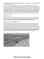
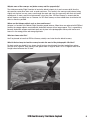
USER’S MANUAL
The Spirit of Flight Simulation
www.justflight.com
USER’S MANUAL
CONTENTS
Please note that Flight Simulator X: Steam Edition must be correctly installed on your
PC prior to the installation and use of this VFR Real Scenery software
INTRODUCTION........................................................................................... 2
DISABLING THE 10M ELEVATION MESH OR THE PHOTO TERRAIN........... 4
UPDATES AND TECHNICAL SUPPORT........................................................ 5
JUST FLIGHT NEWS.................................................................................... 5
ABOUT VFR REAL SCENERY....................................................................... 5
ABOUT GEOPERSPECTIVES...................................................................... 10
COPYRIGHT............................................................................................... 10
VFR Real Scenery: Northern England
1
INTRODUCTION
Welcome to an amazing scenery expansion for Flight Simulator X: Steam Edition.
Just Flight has teamed up with Infoterra Ltd, a leader in the provision of aerial data, for the use of the
GeoPerspectives™ countrywide archive to develop an amazing photographic scenery package for Flight
Simulator X covering the whole of England and Wales in four volumes.
High resolution digital aerial images of the UK are used to transform Flight Simulator X into the real
landscape you can see from the air. With brilliant resolution, night lighting and water effects, this scenery
really is as real as it gets!
VFR stands for ‘Visual Flight Rules’ – this is the way that pilots navigate when they aren’t using complex
instruments. They look at a map and then pinpoint landmarks on the ground to work out their course and
position. It’s the most common form of recreational flying undertaken in the UK, but to do this in a flight
simulator requires scenery that’s exactly the same as the real landscape. VFR Real Scenery is an amazing
piece of software that provides just that – fly over England and Wales in Flight Simulator X and you will see
the view you’d get from a real aircraft. You can see the real countryside from the air and pinpoint every key
landmark. It’s all featured – streets, buildings, rivers, lakes, reservoirs and more… and all at extremely high
resolution and detail!
We’ve individually retouched all the main water features so that they display Flight Simulator X water
effects. You can land a seaplane on the water in VFR Real Scenery!
Night lighting effects have been included across the entire scenery area – all painstakingly edited by
Just Flight to ensure realism.
The entire VFR coastline and the sea in Flight Simulator X have been carefully joined – the effect is brilliant
and you can still use the FSX map system.
Differences in runway alignment between photographic scenery and the default have been individually
corrected – you won’t see any ghosts in VFR Real Scenery!
The colours of the scenery in VFR Real Scenery have been carefully corrected to avoid garish hues and
ensure that the countryside looks realistic.
VFR Real Scenery includes 9.6m mesh terrain data to ensure that the ups and downs of the landscape are
as accurate as possible.
2
VFR Real Scenery: Northern England
THE VFR REAL SCENERY SERIES
Four volumes of Just Flight’s VFR Real Scenery series for FSX: Steam Edition are available. Installing all four
volumes will give you complete coverage of England and Wales.
Volume 1 – South East England
Covers all of Greater London, Kent, East Sussex, Essex, Suffolk, Norfolk, Cambridgeshire and parts of
Hertfordshire, Bedfordshire, Buckinghamshire, Surrey and West Sussex.
Principal towns covered include: Canterbury, Folkestone, Dover, Brighton, London, Basildon, Colchester,
Ipswich, Norwich, Cambridge, Peterborough, Luton and Watford.
Volume 2 – Central & Southern England
Covers all of Hampshire, Berkshire, Wiltshire, Oxfordshire, Gloucestershire, Warwickshire, Worcestershire,
Leicestershire, Nottinghamshire, Staffordshire and parts of Northamptonshire, Derbyshire, Shropshire,
Herefordshire and Cheshire.
Principal towns covered include: Southampton, Portsmouth, Reading, Salisbury, Swindon, Oxford,
Cheltenham, Milton Keynes, Northampton, Birmingham, Leicester, Nottingham, Derby and Stoke.
Volume 3 – Wales & South West England
Covers all of Wales, Cornwall and Devon and parts of Somerset, Dorset, Herefordshire, Worcestershire
and Cheshire.
Principal towns covered include: Truro, Plymouth, Exeter, Barnstaple, Taunton, Weymouth, Bristol, Cardiff,
Swansea, Aberystwyth, Caernarfon, Shrewsbury, Hereford and Chester.
Volume 4 – Northern England
Covers all of Yorkshire, Lancashire, Greater Manchester, Durham, Northumberland, Cumbria and parts of
Merseyside, Derbyshire and Humberside.
Principal towns covered include: Sheffield, Leeds, Bradford, Doncaster, Hull, Manchester, Liverpool,
Lancaster, Kendal, Carlisle, Newcastle, Middlesbrough and York.
VFR Real Scenery: Northern England
3
DISABLING THE 10M ELEVATION MESH OR THE PHOTO TERRAIN
Because of the way FSX forces all airports to be on a flat surface, even if the real-life airport follows the
actual terrain, you can see some unwanted side effects when a much more detailed elevation mesh is
present. This may show as the airport appearing to be sunk slightly in the ground or raised on a plateau.
As the 10m Elevation Mesh provided with VFR Real Scenery is 64 times more detailed than the default FSX
elevation data for the United Kingdom, this effect can be very noticeable at some airports. There may be
times when you wish to revert to the default elevation data when flying in some areas. You can use the FSX
scenery library to deactivate and reactivate the elevation mesh without affecting the Photo Terrain as well.
Go to the main settings screen in FSX and select the ‘Scenery Library’ option. Or, if you are currently flying
in FSX, select the Scenery Library entry from the menu. This will display a list of all the scenery areas and a
checkbox next to each entry which can be used to activate or deactivate just that area. Find the entry ‘VFR
Real Scenery – Area x Mesh’ (where ‘x’ is the area you wish to deactivate) and click on the checkbox next
to it to clear the tick. Click OK and you will be taken back to where you were before and the changes you
have made will be transferred to the FSX world.
To reactivate the 10m Elevation Mesh
just repeat the same process but put a
tick in the box this time.
There may also be occasions when you want to deactivate the Photo Terrain and fly over the default FSX
scenery. The Photo Terrain can be deactivated and reactivated in the same way as the mesh. The entry
to look for in the scenery library list is ‘VFR Real Scenery – Area x Photo’ where ‘x’ is the area you wish to
switch on or off.
4
VFR Real Scenery: Northern England
UPDATES AND TECHNICAL SUPPORT
Please check the News and Support pages on our website at justflight.com for news about updates for this
add-on and for our other products.
Please contact the Just Flight Support team (www.justflight.com/support) if you have a query about this
volume of VFR Real Scenery.
If you have an issue specific to FSX: Steam Edition, please send an email to [email protected].
JUST FLIGHT NEWS
To get the latest news about Just Flight products, sign up for our newsletter and regular emails at
justflight.com/newsletter.
You can also keep up to date with Just Flight via Facebook (facebook.com/justflight) and Twitter
(twitter.com/justflight).
ABOUT VFR REAL SCENERY
What are the best settings for using VFR Real Scenery in Flight Simulator X?
Level of Detail radius – Large
Mesh complexity – 100
Mesh Resolution – 10 m
Texture Resolution – 1 m
Water effects – High 1.x or High 2.x
Scenery complexity – very sparse
Autogen density – none
These Scenery complexity and Autogen density settings remove all the 3D objects and may result in some
buildings not being included at airports. However, we think this a better compromise than having badly
misplaced FSX objects appearing in the same place as their correctly placed VFR counterparts.
VFR Real Scenery: Northern England
5
Why does my VFR Real Scenery look blurry?
Please ensure anti-aliasing and anisotropic filtering are enabled in the FSX Graphics settings menu as that
sharpens up the textures. Your graphics card control panel should also have settings to improve this.
Please note that VFR is best viewed at 3,000ft minimum; this is when you will see the full 3D experience.
Where should I set the Global Texture Resolution?
We recommend the highest setting your PC can handle. Experiment with the settings to achieve the best
compromise between performance and visual appearance. Raising or lowering this setting will mainly affect
how the scenery displays in the far distance and not in the area nearest to your aircraft.
I don’t want to use the FSX water effects that are included – how do I turn them off so that I just see
the photographic images of the water?
Go to the Settings > Display > Scenery menu in Flight Simulator X and turn the Water Effects slider to
Low 1.X or None.
6
VFR Real Scenery: Northern England
As I fly over some areas, especially from high altitudes, I can sometimes see a change in the colour
of the landscape. Why is this?
This is a function of how photographic scenery works. The aerial photographs that go to make up the
scenery are usually taken between March and September because this is the time of year when aircraft can
fly most often and the weather conditions allow photographs to be taken. As a result, when large numbers
of images are put together to form areas of scenery, you can occasionally see seasonal variations between
areas photographed at different times of the year. This shows up as a slight change in the general colour of
the landscape between one area and another. One way round this is to ‘correct’ all the colours artificially.
Unfortunately, this can lead to some very unrealistic hues in the landscape – blue/grey fields and purple
rocks! For this reason we have kept the correction levels to an absolute minimum. The trade-off for this
is some seasonal variation, but we think that these very occasional changes are preferable to an overall
‘unrealistic’ set of colours.
What is 25cm data?
When we say ‘25cm data’ we mean that the original digital images are at a resolution of 25cm per pixel.
That’s pretty accurate! These 25cm images are then optimised to be displayed at 1m per pixel in Flight
Simulator X. The higher the original resolution, the better the quality will be when processed to a lower
resolution. 1m gives the best compromise between appearance, performance and file size.
What are terrain mesh and elevation data?
The visual scenery you see when flying in Flight Simulator is all built upon a basic framework (a ‘mesh’)
that represents the height of the ground at any point in the world. This provides the three-dimensional
relief model of hills, mountains, valleys, cliffs, depressions, plateaux and so forth, upon which all other
scenery objects and ground textures are placed. The vast majority of the area of the default relief model of
England and Wales in Flight Simulator X is set at 76m between each reference point. This means that there
are no relief detail changes between points less than 76m apart. This creates a very “soft” terrain where
mountains that should be craggy appear as smooth rounded hills and individual features that fall between
the points are lost completely. VFR Real Scenery includes reference points that are just 9.6m apart which
provides a far higher resolution than the default. Even small ground features now become visible.
VFR Real Scenery: Northern England
7
OK, I understand the ‘mesh’ but I’ve seen mesh quoted at 9.6m and 10m – what’s the difference?
FSX uses a simplified set of values in the scenery settings options. This avoids things becoming confusing
and makes it easier for the user to visualise. When adjusting the Mesh Resolution slider in the Scenery
options you will see values like 38m, 19m, 10m, 5m and 2m offered. These in fact are the simplified labels
given to the real values. If you select the 10m setting then the actual resolution selected will be 9.6m.
Mesh described as “10m mesh” is actually 9.6m mesh when used in FSX
The scenery looks too dark or too bright at night – can it be improved?
Some computer monitors display a very dark picture, which will look fine most of the time but can result
in the VFR scenery appearing very dark during the night time hours – this is particularly obvious on some
older TFT or laptop screens. To help compensate for this, try adjusting your monitor settings such as the
brightness and contrast. Conversely, if you feel that the scenery is too light at night, you should try reducing
the brightness. Also, ensure that you do not have lights in your room shining on your screen as this can
cause reflections on the screen and make dark images look darker than they actually are.
I’m impressed with the default road traffic effects in Flight Simulator X. Will these work with
VFR Real Scenery?
The alignment of the Flight Simulator X roads is spot on and, if you want, you can get the FSX vehicles to
drive along the VFR Real Scenery roads. Simply go to the Settings > Display menu and select Traffic.
Then adjust the ‘Road vehicles’ slider in the Land and Sea Traffic section.
When flying very low along a river some of the bridges seem to have the water “pulled up” to meet
the bridge. Also, some road areas I know to be elevated appear to be on solid banks rather than
raised on supports. Why?
The highly detailed 10m mesh included with VFR Real Scenery is accurate enough to identify the road
surface on the bridges and flyovers as the ground elevation. The result is that the road surface will appear
at the correct height but because of the way the Flight Simulator terrain engine works it the terrain around it
will be stretched up to meet the new elevation. Unfortunately this is unavoidable as the terrain surface has
to remain continuous with no breaks.
At some airports I notice that the airport is on a raised plateau, yet in real life it is not – why is this?
In this case it means that the airport in real life is not on flat even ground but probably situated on a
slope. Flight simulator has to ‘flatten’ and even out the level of the airport to allow the AI traffic to operate
correctly. It raises the lowest part of the airport to be level with the highest part of the airport and gives
the airport a plateau effect around the lowest part. In real life some airports may have as much as 100 feet
difference within the airport area. In Flight Simulator the flattening effect has to cover not just the runways
and taxiways but also the entire area of the airport. The default terrain in Flight Simulator in the UK is
at fairly low detail and so normally this flattening is not noticeable. When the terrain detail is increased
greatly, as with the 10m terrain included with VFR Real Scenery, then it can make it stand out.
If you find this too distracting then you can turn it off – see above for details.
What is the best flying altitude for sightseeing with VFR Real Scenery?
We recommend flying at around 3,000 feet, as this is a similar altitude to that used by real-world pilots
when flying local cross-country flights.
8
VFR Real Scenery: Northern England
Why do some of the runways and photo-scenery not line up perfectly?
The database used by Flight Simulator to locate the default airports is of much coarser detail than the
data used to create other items such as roads and rivers. This results in the runways and taxiways being
slightly out of place in many cases, even though the roads and rivers line up exactly with their real world
counterparts. In most cases this misplacement is less than 20m. VFR Real Scenery is accurate but the
default airports are slightly less so. However, for VFR Real Scenery we have edited these to minimise this
effect as much as possible.
Where are the Autogen objects such as trees and houses?
Autogen is a function of the default Flight Simulator ground textures. When these are replaced with VFR Real
Scenery the autogen objects associated with the default textures will no longer appear. This is a good thing
because the default autogen would look totally out of place in the photographic scenery with houses and
trees all in the wrong places and wrong alignments. .
What are frame rates like?
You’ll be pleased to learn that VFR Real Scenery actually runs faster than the default scenery.
What is the best way to view the scenery to make the most of the photographic 3D effect?
For best results you should fly in a slower aircraft and you should select the virtual cockpit from where
you view area is greater. Also, looking at the ground from an angle of about 10 or 15 degrees rather than
straight ahead enhances the 3D view.
VFR Real Scenery: Northern England
9
ABOUT GEOPERSPECTIVES
The imagery and terrain data used in this product are supplied by Infoterra from the GeoPerspectives
range. We are now redefining the quality, type and coverage of aerial-based geographic information
available in the market – building on our foundation of nationwide aerial survey. Using the latest digital
imaging technology GeoPerspectives provides the widest range of aerial survey geo-information products –
aerial photography, colour infra-red imagery, digital terrain model and digital surface model – of England
and Wales and also for main UK towns & cities. Our aim is to deliver the highest accuracy and most
up-to-date aerial photography and height products. GeoPerspectives is a joint venture between Infoterra
and BlueSky International Ltd.
Infoterra Ltd. is a leading provider of geographic information products and services. Its portfolio of
geographic information solutions includes airborne and satellite data acquisition, geo-information creation,
database management and outsourced hosting. Infoterra provides geospatial knowledge to companies
worldwide to help them make informed decisions. The company has major customers in communications,
utilities, engineering, agriculture, defence and oil, gas & mineral exploration. Today, airborne and satellite
data plays a major role supporting key decision makers within government, business and research.
We are committed to supporting these decision makers by remaining at the leading edge of data acquisition.
Infoterra routinely invests in new state-of-the-art digital airborne sensors, for example the ALTM 2033
Laserscanner and the Leica ADS40 digital camera, to support programmes worldwide. Operating aircraft
and a range of sensors we provide comprehensive airborne data from aerial photography to Lidar, as well as
providing custom aerial surveys.
Infoterra Ltd. is part of the Infoterra group which comprises companies in France, Germany and the United
Kingdom, and is a wholly owned subsidiary of EADS Astrium Ltd.
If you are interested in licensing aerial imagery or height data for your own use, visit our online service at
www.geostore.com. For further information about our products and services please visit www.infoterra.co.uk.
COPYRIGHT
©2015 GeoPerspectives™, Just Flight Limited. All rights reserved. Just Flight and the Just Flight logo are
trademarks of Mastertronic Group Limited, 1st Floor, Benjamin Street, London EC1M 5QG, United Kingdom.
All trademarks and brand names are trademarks or registered trademarks of the respective owners and their
use herein does not imply any association or endorsement by any third party.
10
VFR Real Scenery: Northern England
The Spirit of Flight Simulation
www.justflight.com
www.geoperspectives.com
www.justflight.com