1
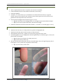
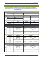
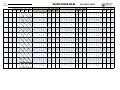
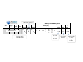
Tahoe Road RAM Road Segment Setup – Quick Guide |1 TAHOE ROAD RAM ROAD SEGMENT SETUP - QUICK GUIDE The following is an update to the Road RAM User Manual, providing helpful hints to establish a road segment. This step is performed one time, and once established the location and boundary will not change. 1 SEGMENT SETUP (ONE TIME) This step can be initiated in the office using Google Maps or similar, and then confirmed in the field. 1.1 SELECT 10,000 FT 2 ROAD SEGMENT FOR OBSERVATIONS Assign each road segment a unique ID. Use a stop sign or crosswalk as one boundary when possible. This will provide a safe place to cross street during observations. Never select site on a curve. At least 300ft of visibility from oncoming traffic should be available from both directions. 1.2 DETERMINE DIMENSIONS OF THE ROAD SEGMENT Determine road width of all continuous impervious surfaces including sidewalks, up to a maximum width of 65 ft. If using Google Maps, measure in feet. If in the field, find a safe place to cross the street and count number of paces (1 pace = 3 ft). Use Table 1 to convert between feet and paces. Tip: Know your personal pace for a 3ft step. Practice using measuring tape. Determine road length based on road width to define the consistent 10,000 ft 2 using Table 2. Convert feet to paces using Table 1. Walk length of the road segment and identify any landmarks to denote boundaries of segment. 2NDNATURE, LLC | ecosystem science + design www. 2ndnaturellc.com | 831.426.9119 2| December 2013 Table 1 converts distance measured in feet to approximate number of 3ft paces. Table 2 equates measured road width in feet to corresponding road length (ft) for a 10,000 ft 2 road segment. Distance (ft) 10 20 30 40 50 60 70 150 175 200 225 Table 1 3 ft Paces (#) Distance (ft) 3 7 10 13 17 20 25 50 60 70 80 250 275 300 325 350 375 400 425 450 475 500 2NDNATURE, LLC | ecosystem science + design 3 ft Paces (#) 85 90 100 110 120 130 135 140 150 160 170 Table 2 Width (ft) Length (ft) 20 30 40 50 60 70 500 330 250 200 170 140 www. 2ndnaturellc.com | 831.426.9119 Tahoe Road RAM Field Observations – Quick Guide |1 TAHOE ROAD RAM FIELD OBSERVATIONS - QUICK GUIDE This is an update to the Road RAM User Manual Step 4B Field Observation protocols, meant to summarize the key protocols and provide helpful hints to complete Road RAM field observations quickly and safely. 1 SAFETY TIPS Field personnel safety is more important than road condition. Always use your best judgment. Never make observations in conditions that are unsafe (e.g., poor visibility due to weather or darkness, slippery road conditions, commute hours, etc.). 2 Work in pairs. Always wear brightly colored safety vest. Use crosswalks when available. Never park in drive lane. If parked on road shoulder, use safety cones & hazard lights. Be aware of traffic. Do not put your back to oncoming traffic. WHAT TO BRING 3 Safety vest Clipboard Field Datasheet Hand broom Pencil Baby wipe FIELD OBSERVATIONS (EVERY TIME) Field observations should not be made when pavement is wet or there are high winds. Populate the field datasheet with each road segment ID and length/width pacing prior to going into the field to conduct field observations (Figure 1, note A). A blank field datasheet is attached at the end of this guide. Figure 1. Field datasheet. Letters are used within quick guide to refer to data entry for specific field observations. 2NDNATURE, LLC | ecosystem science + design www. 2ndnaturellc.com | 831.426.9119 2| December 2013 3.1 DETERMINE ACCUMULATION DISTRIBUTION Arrive at segment and use pacing to orient yourself with the segment boundary. Walk the perimeter, visually assessing material accumulation patterns and distribution throughout segment. Depending on time of year and road condition, there can be 1-3 material accumulation areas. The delineation of heavy, moderate and light zones is relative to that segment at that time of observation. Tip: It is easiest to identify the cleanest (light, usually the drive lane) and dirtiest (heavy, usually the road shoulder) first, and then decide if there is an intermediate (moderate) zone. Find a representative cross section of the accumulation pattern. Starting on road shoulder, count paces for heavy and moderate accumulation areas (Figure 1, note B) across width of road. Only cross road where it can be done safely. Calculate light zone. Resolution is 0.5 paces. Tip: The light zone is typically the drive lane, so rather than pacing, calculate as: Light = Width – Heavy – Moderate. Calculate % distribution for each accumulation zone based on incremental pacing results. Round answers to nearest 5% (Figure 1, note C). Visually confirm that distribution percentages make sense. 3.2 ESTIMATE VOLUME OF MATERIAL For each accumulation zone, select a representative and safe 1x1 square. Visually estimate the volume of material within the square based on the 7 categories on field datasheet (Figure 1, note D). Observation includes both fine and coarse material, and any material within cracked pavement. Do not include organic material (e.g., pine needles, leaves, etc.) in estimate. Tip: Practice visually estimating volume of material in 1 x 1 area based on the 7 categories. Know the categories and gain the skill of estimating the volume of material each category represents to avoid sweeping and measuring material. We recommend practicing in a safe environment (e.g., parking lot) to improve estimation skills. 3.3 DEGREE OF FINES TESTS Road RAM scoring is highly sensitive to the degree of fines. Figure 2 provides a schematic detailing the sequence and priority of observations, with the dust test height being the priority. The end member dust test results - waist and no cloud - allow the user to assume the answers to other tests. When intermediate dust heights are observed (knee or ankle), additional user measurements are required. The red ‘user determine’ boxes indicate when these observations are critical for determining the level of fines within the 1x1 square. Figure 2. Sequence to perform degree of fines tests. 2NDNATURE, LLC | ecosystem science + design www. 2ndnaturellc.com | 831.426.9119 Tahoe Road RAM Field Observations – Quick Guide 3.3.1 |3 DUST CLOUD Select a representative and safe 1x1 square for each area of accumulation. Position backside upwind so dust will blow the direction you are facing. Place heels together. Sweep the 1 x 1 area in front of you. The intention is to create a dust cloud with 3 to 4 vigorous sweeps. The user must make firm and consistent contact with the ground to ensure a dust cloud is generated if fines are present on the road surface. 3.3.2 Record maximum height that cloud reaches (Figure 1, note E). Tip: Best observed by non-sweeping partner, as max height may be reached behind sweeper. Tip: If you are unsure, repeat. Still unsure, select the lower height. Determine the duration the dust cloud remains visible as < 2 seconds or ≥ 2 seconds (Figure 1, note F). FINGERPRINT TEST Adjacent to the dust test, in a visually similar area, perform the fingerprint test. Wipe hands with baby wipe to make sure they are clean and moist. With moderate pressure rub 2-3 fingers into road surface, going side to side 2 times. Examine fingerprints. Are your fingerprints visible through the layer of material? (Figure 1, note G.) See photos below for examples. Tip: If any part of your finger is not visible, answer ‘no’. Tip: If you are unsure, answer ‘yes’. Wet your thumb with the baby wipe, and then rub middle finger. Does your finger feel gritty, slimy or both? (Figure 1, note G.) When wet, clay particles will feel slimy. Tip: If you are unsure, answer ‘both’. Figure 3. Examples of fingerprint visibility. 2NDNATURE, LLC | ecosystem science + design www. 2ndnaturellc.com | 831.426.9119 4| 4 December 2013 FIELD DATASHEETS Field datasheets provided as (1) original form for single road segment and (2) updated row datasheet for multiple segments. Log on to www.tahoeroadram.com to enter observations and obtain road condition score. Row # ROAD RAM STEP 4 Field Observation Datasheet Field Personnel Observation Date RS ID 1 Road Segment (RS) Length RS Start Width 2 pace pace ft ft RS End Percent Distribution Material Accumulation Area Heavy Moderate 3 4 5 6 Light % of Road Segment Volume (ml) 0 0-1 1-5 5 - 10 10 - 30 30 - 100 > 100 Volume (ml) 0 0-1 1-5 5 - 10 10 - 30 30 - 100 > 100 Volume (ml) 0 0-1 1-5 5 - 10 10 - 30 30 - 100 > 100 Dry Material Collection HEAVY MATERIAL ACCUMULATION AREA Fines Test Finger print visible? No Material Yes No Height Gritty / Both / Slimy Seconds Dust Test No Cloud Ankle Knee Waist < 2 seconds >2 seconds MODERATE MATERIAL ACCUMULATION AREA Fines Test Dust Test Finger print visible? No Material Yes No Height Gritty / Both / Slimy Seconds No Cloud Ankle Knee Waist < 2 seconds LIGHT MATERIAL ACCUMULATION AREA Fines Test Finger print visible? No Material Yes No Height Gritty / Both / Slimy Seconds 2NDNATURE, LLC | ecosystem science + design >2 seconds Dust Test No Cloud Ankle Knee Waist < 2 seconds >2 seconds www. 2ndnaturellc.com | 831.426.9119 DATE TAHOE ROAD RAM FIELD DATA SHEET > 100 < 2 > 2 Y N S G B > 100 none A K W < 2 > 2 Y N S G B > 100 none A K W < 2 > 2 Y N S G B > 100 none A K W < 2 > 2 Y N S G B > 100 none A K W < 2 > 2 Y N S G B > 100 none A K W < 2 > 2 Y N S G B > 100 none A K W < 2 > 2 Y N S G B > 100 none A K W < 2 > 2 Y N S G B > 100 none A K W < 2 > 2 Y N S G B > 100 10 to 30 10 to 30 10 to 30 10 to 30 10 to 30 10 to 30 10 to 30 10 to 30 10 to 30 10 to 30 10 to 30 none A K W none A K W < 2 > 2 Y N S G B > 100 5 to 10 5 to 10 5 to 10 5 to 10 5 to 10 5 to 10 5 to 10 5 to 10 5 to 10 5 to 10 5 to 10 Y N S G B 1 to 5 < 2 > 2 0 to 1 none A K W 1 to 5 Y N S G B 0 to 1 < 2 > 2 1 to 5 > 100 none A K W 0 to 1 Y N S G B 1 to 5 < 2 > 2 0 to 1 > 100 none A K W 1 to 5 Y N S G B 0 to 1 < 2 > 2 1 to 5 > 100 none A K W 0 to 1 Y N S G B 1 to 5 < 2 > 2 0 to 1 > 100 none A K W 1 to 5 Y N S G B 0 to 1 < 2 > 2 1 to 5 > 100 none A K W 0 to 1 Y N S G B 1 to 5 < 2 > 2 0 to 1 > 100 none A K W 1 to 5 Y N S G B 0 to 1 < 2 > 2 0 > 100 none A K W 0 Y N S G B 0 < 2 > 2 0 > 100 none A K W 0 Y N S G B 0 < 2 > 2 0 > 100 none A K W 0 Y N S G B 0 < 2 > 2 0 > 100 none A K W Dust Time Finger Height (sec) test Volume (mL) 0 Finger test > 100 30 to 100 30 to 100 30 to 100 30 to 100 30 to 100 30 to 100 30 to 100 30 to 100 30 to 100 30 to 100 30 to 100 5 to 10 10 to 30 5 to 10 10 to 30 5 to 10 10 to 30 5 to 10 10 to 30 5 to 10 10 to 30 5 to 10 10 to 30 5 to 10 10 to 30 5 to 10 10 to 30 5 to 10 10 to 30 5 to 10 10 to 30 10 to 30 10 to 30 10 to 30 10 to 30 10 to 30 10 to 30 10 to 30 10 to 30 10 to 30 10 to 30 10 to 30 5 to 10 5 to 10 5 to 10 5 to 10 5 to 10 5 to 10 5 to 10 5 to 10 5 to 10 5 to 10 5 to 10 5 to 10 1 to 5 1 to 5 1 to 5 1 to 5 1 to 5 1 to 5 1 to 5 1 to 5 1 to 5 1 to 5 1 to 5 30 to 100 30 to 100 30 to 100 30 to 100 30 to 100 30 to 100 30 to 100 30 to 100 30 to 100 30 to 100 30 to 100 0 0 to 1 0 0 to 1 0 0 to 1 0 0 to 1 0 0 to 1 0 0 to 1 0 0 to 1 0 0 to 1 0 0 to 1 0 0 to 1 0 10 to 30 Y N S G B 1 to 5 < 2 > 2 1 to 5 none A K W 1 to 5 Y N S G B 1 to 5 < 2 > 2 1 to 5 > 100 none A K W 1 to 5 Y N S G B 1 to 5 < 2 > 2 1 to 5 > 100 none A K W 1 to 5 Y N S G B 1 to 5 < 2 > 2 1 to 5 > 100 none A K W 0 to 1 Y N S G B 0 to 1 < 2 > 2 0 to 1 > 100 none A K W 0 to 1 Y N S G B 0 to 1 < 2 > 2 0 to 1 > 100 none A K W 0 to 1 Y N S G B 0 to 1 < 2 > 2 0 to 1 > 100 none A K W 0 to 1 Y N S G B 0 to 1 < 2 > 2 0 > 100 none A K W 0 Y N S G B 0 < 2 > 2 0 > 100 none A K W 0 Y N S G B 0 < 2 > 2 0 > 100 none A K W 0 Y N S G B 0 < 2 > 2 0 > 100 none A K W LIGHT Dust Time Height (sec) Volume (mL) 0 Finger test Volume (mL) 0 to 1 Juris MODERATE Dust Time Height (sec) > 100 HEAVY Length Width Heavy Mod Light Seg ID (pace) (pace) (pace) (pace) (pace) 30 to 100 30 to 100 30 to 100 30 to 100 30 to 100 30 to 100 30 to 100 30 to 100 30 to 100 30 to 100 30 to 100 Personnel none A K W < 2 > 2 Y N S G B WIDTH PACE COUNT Light (pace) Calculate width % DISTRIBUTION > 100 Volume (mL) 30 to 100 PRE‐POPULATED Mod (pace) 10 to 30 Heavy (pace) 5 to 10 Width (pace) 1 to 5 Length (pace) 0 to 1 Seg ID 0 Juris HEAVY/MODERATE/LIGHT Dust height Time (sec) Finger test none A K W < 2 > 2 Y N S G B A= ankle K = knee W = waist Dust cloud duration yes/no visible S = slimy G = gritty B = both