1
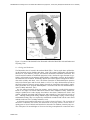
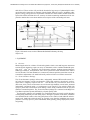
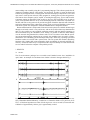
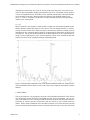
ROCKENG09: Proceedings of the 3rd CANUS Rock Mechanics Symposium, Toronto, May 2009 (Ed: M.Diederichs and G. Grasselli)
Rock mechanics and subsurface imaging at DUSEL, Homestake
mine
J.K. Van Beek and W.M. Roggenthen
South Dakota School of Mines and Technology, Rapid City, USA
M. Magliocco and S.D. Glaser
University of California, Berkeley, USA
ABSTRACT: The Deep Underground Science and Engineering Laboratory (DUSEL) is a scientific facility that will be placed in the deeper reaches of the Homestake mine, Lead, SD. Our
team of geologists and engineers is carrying out the first scientific project awarded to the site –
Towards a Transparent Earth. Taking advantage of the thousands of open exploratory and sandline holes, we are installing the beginnings of a seismic observatory. Each installed station consists of a 3-D accelerometer package and a 1 nanoradian 2-D tilt meter.
In order to allow for a variety of monitoring and characterization studies, the array instruments
are sensitive over the frequency bandwidth of 0.2 - 1 KHz. Three, three-component accelerometer stations are currently installed – in a 140 m deep bore beneath the slurry pump house, and
in 12 m deep bores on the 2000-foot level, 800 and 400 m from the Ross shaft. There is a tiltmeter installed at each 2000 level station. These installations are in 150 mm diameter sandholes.
From the currently installed tilt sensors we are investigating solid earth deformation as a response to tidal potential. The accelerometers are being used to locate and characterize events associated with mine dewatering and rehabilitation.
1 INTRODUCTION
1.1 Location and History
Operating from 1876 to 2001 in the northern Black Hills of South Dakota, the Homestake gold
mine (Fig. 1) extracted about 42,000,000 oz of gold from depths reaching 2.4 km. In its 125
year history 560 km of drift and several hundred stopes were opened. The mine ceased operations in 2001 after several years of low gold prices. The mine has a long history of close association with particle physics experiments, most notably the work of Ray Davis who established a
Nobel Prize-winning neutrino detection experiment in the mine in 1965. Closure of the mine
provided the opportunity to use the mine as a laboratory and has led to the conversion of the
mine into a dedicated underground science and engineering laboratory. The Sanford lab at Homestake currently provides the infrastructure for scientific experiments in the fields of astrophysics, geology, geophysics, microbiology, and hydrology.
PAPER 4155
1
ROCKENG09: Proceedings of the 3rd CANUS Rock Mechanics Symposium, Toronto, May 2009 (Ed: M.Diederichs and G. Grasselli)
Figure 1. Location of the Sanford Lab at Homestake within the Black Hills of South Dakota and
Wyoming, USA.
1.2 Geology and Production
The Homestake mine is located in the northern Black Hills, a Tertiary-aged dome, uplifted during the Laramide orogeny (Redden and others, 1990). The primary stratigraphic units found in
the mine are, from oldest to youngest, the Poorman, Homestake, and Ellison Formations. The
lower Poorman Formation is hornblende-plagioclase schist, whereas the upper Poorman is typified by well-layered sericite-carbonate-quartz phyllite. Conformably overlying the Poorman is
the Homestake iron-formation, dominantly chlorite-chert-siderite phyllite and grunerite-biotitechert schist (Caddey and others, 1991). The Ellison Formation is interbedded impure quartzite
and sericite-biotite-quartz and has been dated at 1.97Ga. Two major deformational periods in
the Early Proterozoic formed a steeply dipping, sheared set of anticlines and synclines. Amphibolite-greenschist facies prograde metamorphism is associated with the first deformational sequence (Caddey and others, 1991).
Ore was removed primarily from nine separate, steeply plunging, synclinal fold structures
known as ore ledges. Ore trends within these structures were composed of many sulfide-rich,
elongate cylindrical ore bodies ranging from 2000 to more than 1,000,000 tons. Gold is fine
grained, commonly associated with arsenopyrite, and averaged 8.4 g Au/t with a Au/Ag ratio of
10:1. Although underground mining methods began with shrinkage stoping, timber stoping,
and drawhole mining, they were replaced by mechanized cut-and-fill and vertical crater retreat
methods in the late 1930’s (Caddey and others, 1991).
A schematic representation of the mine cross section is shown in Figure 2. The conversion of
the mine to a laboratory will involve the construction of very large cavities, in some cases requiring spans of 20 m at 4850 ft and 7400 ft below the surface. In addition, extremely large cavities with spans of 50 m and heights of 50 m are also being contemplated for construction at the
PAPER 4155
2
ROCKENG09: Proceedings of the 3rd CANUS Rock Mechanics Symposium, Toronto, May 2009 (Ed: M.Diederichs and G. Grasselli)
4850 ft level. These cavities will provide the location for large arrays of photomultiplier tubes
used to detect the interaction of neutrinos with the liquids filling the cavities. In addition, other
physics, biology, and geosciences experiments will make use of the smaller modules with 20 m
spans at the 4850 ft and 7400 ft levels. An array of seismic monitoring installations will be emplaced to monitor these excavations and the stress response of the surrounding rock mass.
Figure 2. Schematic cross section of Homestake/Sanford Laboratory showing
major levels.
2 EQUIPMENT
2.1 Overview
Monitoring the mine for evidence of local and regional seismic events and long-term movement
associated with dewatering requires an array of instruments with a combined bandwidth spanning 1x10³ - 1x10⁻⁸ Hz. Down-hole 3D accelerometer packages, platform mounted dual-axis
bubble-type tiltmeters, and hydrostatic water level systems have been installed on the 2000 ft
level of the mine. This instrumentation is connected to a data acquisition system that records data and allows adjustments to be made both locally and in real-time over internet connections.
2.2 3D Accelerometer Package
The 3D accelerometer package utilizes three, orthogonally mounted Wilcoxon Research 731207 ultra low frequency seismic accelerometers. These high sensitivity piezoelectric accelerometers have a frequency response from 0.2 – 1,300 Hz and very low electronic noise levels
(Wilcoxon, 2001). These accelerometers are wired with high durability coaxial cable, mounted
orthogonally, and placed inside a 13 cm diameter, 80 cm long PVC pipe which is filled with
epoxy to protect the accelerometers from damage, ensure strong connection with the pod, and
minimize resonant frequencies. The 3D Accelerometer packages are connected to the Magliocco
Type Data Acquisition System (MTDAS) by oil-patch quality cable.
Accelerometer packages were installed in 16 cm diameter holes previously used for drainage
or transporting sand slurry for back filling stopes. During the operation of the mine, sand holes
were drilled from the surface at the slurry pump house to the 1100 level and within the mine between levels. Sand holes within the mine are typically open, therefore installation was accomplished in a four step process: packer installation, initial grouting, package deployment, and final grouting.
PAPER 4155
3
ROCKENG09: Proceedings of the 3rd CANUS Rock Mechanics Symposium, Toronto, May 2009 (Ed: M.Diederichs and G. Grasselli)
2.3 Tiltmeters
Two different types of tiltmeters are presently installed in the Homestake underground, including Applied Geomechanics 711-2A Platform Tiltmeters and Fermilab Hydrostatic Water Level
Sensors (HLS). The Applied Geomechanics platform tiltmeters are capable of detecting rotations as small as 0.5 nano-radians (d’Oreye, 1998) with two, orthogonal, electrolytic level sensors contained within a rugged, hermetically sealed, enclosure mounted to a 15 cm by 15 cm
anodized aluminum base (Applied Geomechanics, 2005). Frequencies from DC to 2.5 Hz can be
detected with this unit capable of monitoring low frequency components of seismic events, earth
tides, seasonal trends, and stress realignment associated with mine dewatering. The platform
tiltmeter is connected to the MTDAS via a 3 m cable, through which power is received and data
is sent. Currently this type of tiltmeter is installed at the 2000 ft level in the underground (See
Fig. 2). The instruments are mounted on a 30 cm diameter concrete pedestals reinforced by
three, 1.9 cm diameter, rebar rods embedded 30 cm into the intact rock.
The Fermilab tiltmeters, originally designed to monitor the Tevatron particle accelerator at
Fermilab, determine relative height changes over a distance by measuring water levels in halffilled vessels in hydraulic communication via two polyethelene tubes (Volk and others, 2006).
Installed on the 2000 ft level of the mine are two arrays, each comprised of two legs. Every leg
is 120 meters in length and defined by three vessels with a 60 m separation. Changes in water
level amongst the three vessels can be used to determine the orientation of a vector
representative of that leg. The two vectors of an array can be used to calculate time dependent
orientation changes of a plane representative of the 2000 level rock mass.
2.4 Magliocco Type I Data Acquisition System (MTDAS)
The MTDAS was designed to be a quickly deployable, flexible, and robust unit capable of surviving the ambient operating conditions within the mine, which are characterized by high humidity and temperatures of up to 35 oC. The data acquisition system hardware is composed of a
PC104-Plus form factor single board computer mated with two analog to digital data acquisition
boards and a power supply all housed within a sealed aluminum box. The key aspects of the
PC/104-Plus standard are the 9 cm × 9.6 cm motherboard footprint and a stackable PCI bus in
which extra components can be simply stacked on the motherboard to add functionality. These
computers and components feature rugged construction and design intended for embedded and
industrial applications. The main computer board utilized in the first installation is a Kontron
MOPSPM104 which features an Intel® Celeron®-M 600MHz CPU, and is outfitted with 1GB of
SDRAM and an 8GB, flash based, hard drive. Subsequent installations use the Kontron
MOPSlcdLX mother board and AMD Geode LX800 CPU to reduce operating temperatures
within the enclosure.
Tilt meter measurements are collected via a Diamond-MM-16-AT 16 bit analog I/O PC/104
module manufactured by Diamond Systems Corporation which features autocalibration and 16
analog inputs. The accelerometer measurements are digitized by a National Instruments PCI
4462 high-performance, high-accuracy, analog signal acquisition board providing 204.8 kS/s,
anti-alias filtering, and IEPE current excitation capability that is required for the piezoelectric
accelerometers. To use this board with the PC/104-Plus a PCI adapter board was included, as
well as a power supply to provide the PCI bus power. The MTDAS enclosure is a sealed extruded aluminum box with internal and external heat sinks and an internal fan to aid in heat dissipation. In addition to excellent heat management, the aluminum enclosure is sturdy enough to
meet the “kick proof” requirements of the mine environment.
The system operates on Fedora Core 7 Linux, a community-produced and supported version
of the Red Hat Linux operating system compatible with the Diamond analog I/O board, Kontron
motherboard, and the Labview Runtime Environment. These features allow it to run precompiled Labview programs and enables remote administration, networking, and customization. To
capture data from the National Instruments board a basic Labview program was written to read
data from the accelerometer channels into a buffer that is monitored for a trigger condition.
When the trigger condition is met the buffer and subsequent data are recorded. The Labview application includes a graphical user interface as well as an initialization file to control the data
acquisition parameters and trigger conditions. The software used to configure and record the tilt
PAPER 4155
4
ROCKENG09: Proceedings of the 3rd CANUS Rock Mechanics Symposium, Toronto, May 2009 (Ed: M.Diederichs and G. Grasselli)
meter readings was created by using the C programming language. This software permits the adjustment of sampling interval, gain settings, and averaging. In order to ensure bi-directional
connectivity through firewalls, a virtual private network was employed. OpenVPN is a free and
open source virtual private network (VPN) program for creating point-to-point encrypted tunnels between host computers and is capable of working through proxy servers and firewalls.
Computers running an OpenVPN client are able to log on to the OpenVPN server in order to
join a virtual network that runs on top of the underlying network connections. OpenVPN uses
the SSL and TLS security protocols to provide encryption of both the data and control channels
and can be authenticated using a shared key system. Upon receiving an IP address on the virtual
network the system was configured to email the administrator the assigned IP number.
Remote administration is simple under Linux and several options are available. Remote logon
through a text based console is easy and secure, and can be used for almost any administration
task. It is also possible to run a graphical application remotely with the interface appearing on
the local machine using an X Windows server. Finally it is possible to share the entire desktop
over the network using standard free software such as Xvnc. In order to ensure that the operating system and networking continued to run correctly, the watchdog timer was used in conjunction with the cron scheduling system and simple shell scripts. In this way, operating system and
hardware crashes are resolved with a system reboot. The cron system also monitors networking
functions with a simple shell script automated to check periodically for network and VPN connectivity. If network connectivity is compromised the script will attempt to restart the network
services and will reboot the computer if the problem persists.
3 RESULTS
3.1 Seismic
The 3D accelerometer packages have recorded several hundred events since installation in
April, 2008. An example of a one minute time window is shown in the upper half of Fig. 3.
a.
b.
Figure 3. Seismic data from the tri-axial seismometer on the 2000 foot level (610 m) below surface), Homestake/Sanford laboratory, recorded on 12 December 2008 at 2:52 pm local (18:52
UTC). a) Plot showing numerous events of local origin over a 60 sec record. b) Event with radial distance of approximately 1200 m. y(0) is approximately vertical.
PAPER 4155
5
ROCKENG09: Proceedings of the 3rd CANUS Rock Mechanics Symposium, Toronto, May 2009 (Ed: M.Diederichs and G. Grasselli)
Although more than twenty five events are obvious in this plot, many more events can be seen
in the raw data at magnitudes slightly greater than the noise level. The bottom portion of Figure
3 shows an expanded scale for one of these events. Both the S-mode and its associated P-mode
can be identified in this plot. Based upon the time difference the estimated distance to the
source is ~1200 m. A number of events have a similar estimated offset and is the approximate
distance to the working shaft.
3.2 Tilt
Initial evaluation in the frequency content of data recorded from the installed Applied Geomechanics tiltmeters display high signal to noise ratios in the semi-diurnal band (Fig. 4) with decreasing resolution in the lower frequencies due to discontinuous and short recording intervals
(maximum 48 days continuous data acquisition), instrument drift, and thermal variations at the
recording site. Several well-defined maxima can be identified which can be correlated after filtering to remove high-frequency noise and low-frequency effects due to mechanical drift and,
possibly, the effects of the ongoing dewatering of the underground.
Figure 4. Principal tidal constituents in the semi-diurnal and diurnal bands from windowed FFT
of de-trended data collected from one axis of the resistive-type (Applied Geomechanics) bubble
tiltmeter.
4 DISCUSSION
This project marks the very beginning of research at the Homestake/Sanford lab. Three element
of a much larger seismic observatory surrounding the mine have been installed. The two stations on the 2000 ft level are working well and the in-house produced data and control system is
performing as expected, and the accelerometer pods are sensitive to tens of small events per
minute. Future seismic installations will concentrate on deeper levels of the laboratory and will
assist in monitoring the deformation effects of construction of the large cavities associated with
PAPER 4155
6
ROCKENG09: Proceedings of the 3rd CANUS Rock Mechanics Symposium, Toronto, May 2009 (Ed: M.Diederichs and G. Grasselli)
the physics experiments. Results of data frequency analysis relate primary signal constituents in
the semi-diurnal range to some values detailed by Wahr (1995). Though longer period tidal constituents are not currently evident in the data, longer monitoring time will likely result in a higher signal to noise ratio in the extremely low frequency range.
Considerable progress has been made already in transforming the former mine into a laboratory that is conducive to scientific research. As progress continues we look forward to further
installations in the mine to benefit of future researchers in many fields in addition to those directly involved with this project. The installation of additional 3D accelerometer pods and tiltmeters will greatly increase the ability to interpret rock mass reactions to events of all types.
Following the completion of the fiber optic network we will be able to make data freely available instantaneously to interested parties via the internet, and increase the precision and accuracy of the timing at all sites. This will enable us to correlate seismic monitoring stations in the
mine with local seismic monitoring sites, increasing the ability to locate local, regional, and
global events.
4.1 Acknowledgments
This project would not be possible without the cooperation of the South Dakota Science and
Technology Authority, Barrick Gold Corporation, Fermi National Laboratory, and the many
subcontractors who have been accommodating throughout the project. G. Lillihaug, B. Pietzeyk,
T. Trancynger, (Sanford Laboratory), and J. Volk (Fermi National Laboratory) were especially
helpful. Support for this project was provided by NSF grant CMMI-0727726.
5 REFERENCES
Applied Geomechanics, 2005, 700-Series platform and surface mount tiltmeters: User’s Manual.
Bachman, R.L., and Caddey, S.W., 1990, The Homestake mine, Lead, South Dakota; an overview. In C. J. Paterson and A.L. Lisenbee (eds.), Metallogeny of gold in the Black Hills,
South Dakota: Society of Economic Geologists Guidebook Series, v.7: 89-94.
Caddey, S.W., Bachman, R.L., Campbell, T.J., Reid, R.R., and Otto, R.P., 1991. The Homestake gold mine, an early Proterozoic iron-formation-hosted gold deposit, Lawrence County,
South Dakota. U. S. Geological Survey Bulletin 1857-J, Geology and Resources of Gold in
the United States.
D’Oreye, N., 1998, Qualification test of a dual-axis bubble-type resistive tiltmeter (AGI-700 series): earth tides recorded and analysed in the underground laboratory of Walferdange. Marees TerrestresBulletin d'Information, 129, 9953–9961.
Meier, L. F., 1990, Structure and ore trend description of the Homestake mine. In C. J. Paterson
and A.L. Lisenbee (eds.), Metallogeny of gold in the Black Hills, South Dakota: Society of
Economic Geologists Guidebook Series, v.7: 95-102.
Redden, J.A., Peterman, Z.E., Zartman, R.E., DeWitt, E.R. 1990. U-Th-Pb Geochronology and
preliminary interpretation of Precambrian events in the Black Hills, South Dakota. In Lewry,
J.F. and Stauffer, M.R., (eds.), The Early Proterozoic Trans-Hudson Orogen of North America. Geol. Assoc. Canada, Spec. Paper 37: 229-251.
Rogers, H., 1990, Geology of Precambrian rocks in the Poorman anticlinorium and Homestake
mine, Black Hills, South Dakota. In C. J. Paterson and A.L. Lisenbee (eds.), Metallogeny of
gold in the Black Hills, South Dakota: Society of Economic Geologists Guidebook Series,
v.7: 103-111.
Volk, J.T., Guerra, J.A., Hansen, S.U., Kiper, T.E., Jostlein, H., Shilsev, V., Chupyra, A., Kondaurov, M., and Singatulin, S., 2006, Hydro static water level systems at Fermilab: 9th international Workshop on Accelerator Alignment, September 26-29.
Wahr, J., 1995, Earth tides, Global Earth physics, AGU Reference Shelf 1: 40-45.
Wilcoxon Research, 2001, Model 731-207 Ultra low frequency seismic accelerometer: Users
Manual.
PAPER 4155
7