1
o
Deliverable N : D4.4
Platform's
Administration Manual
The
Intergeo Consortium
Feb 2009
Version: updated draft
September 30, 2010 1:23 P.M.
Main Authors:
Santiago Egido (Maths for More S.L.)
Paul Libbrecht (DFKI GmbH)
Henri Lesourd (Univ. Montpellier 2)
Project co-funded by the European Community under the
eContentplus Programme
Deliverable D4.4
Platform's Administration Manual
Project ref.no.
ECP-2006-EDU-410016
Project title
Intergeo - Interoperable Interactive Geometry for Europe
Deliverable status
updated draft
Contractual date of delivery
M15 December 2008
Actual date of delivery
February
Deliverable title
Platform's Administration Manual
Type
Report
Status & version
updated draft
Number of pages
49
WP contributing to the deliverable
28th
September 30, 2010 1:23 P.M.
2009
September 30, 2010 1:23 P.M.
WP4
WP/Task responsible
Paul Libbrecht
Authors
Santiago Egido (Maths for More S.L.), Paul Libbrecht
(DFKI GmbH), Henri Lesourd (Univ. Montpellier)
EC Project Ocer
Spyridon Pilos
Keywords
web platform, users, resources, maintenance
License
This document is available under the license
c Intergeo
Creative
Commons Attributions Sharealike Germany 2.5 [?]
Consortium 2008
Page 2 of 49
Deliverable D4.4
Platform's Administration Manual
Contents
1 Introduction: the I2geo Platform, Mission and Choices
6
2 Architecture of the I2geo Platform
8
2.1
The Curriki Web-Application
2.2
Adaptation Strategies from Curriki to
2.3
The Intergeo Search Tool
2.4
The Competency Editor and Ontology Update Server
2.5
The
2.6
Interface of
I2geo
. . . . . . . . . . . . . . . . . . . .
. . . . . . . . . . .
11
. . . . . . . . . . . . . . . . . . . . . .
12
. . . . . .
13
. . . . . . . . . . . . . . . . .
13
to External Web-Services . . . . . . . . . . . .
14
Root Web-Application
I2geo
I2geo
10
3 Installation and Upgrade
15
3.1
Common Installation Practice . . . . . . . . . . . . . . . . . . . .
15
3.2
Installing Curriki . . . . . . . . . . . . . . . . . . . . . . . . . . .
17
3.3
Steps to perform manually . . . . . . . . . . . . . . . . . . . . . .
20
3.3.1
Importing some les
. . . . . . . . . . . . . . . . . . . . .
20
3.3.2
About XWiki's import/export mechanism . . . . . . . . .
21
3.4
3.5
About the install script
(aka: if it doesn't work... ) . . . . . . . . . . . . . . . . . . . .
24
Installing other Web-Applications . . . . . . . . . . . . . . . . . .
26
3.5.1
Installing the Root web application . . . . . . . . . . . . .
26
3.5.2
Installing CompEd and onto-Update server
. . . . . . . .
27
3.5.3
The Intergeo Search Tool
. . . . . . . . . . . . . . . . . .
28
3.5.4
The Search Tool's XWiki Plugin
. . . . . . . . . . . . . .
4 Editorial Activity on I2geo
29
30
4.1
XWiki Syntax . . . . . . . . . . . . . . . . . . . . . . . . . . . . .
30
4.2
Pages, translations, spaces and their management . . . . . . . . .
31
4.3
Panel edition
. . . . . . . . . . . . . . . . . . . . . . . . . . . . .
33
4.4
XWiki groups and their management . . . . . . . . . . . . . . . .
33
4.5
Curriki groups
33
4.6
Activating, deactivating, and deleting users
4.7
Managing CompEd users
c Intergeo
. . . . . . . . . . . . . . . . . . . . . . . . . . . .
Consortium 2008
. . . . . . . . . . . .
34
. . . . . . . . . . . . . . . . . . . . . .
34
Page 3 of 49
Deliverable D4.4
Platform's Administration Manual
5 Monitoring the website
5.1
Monitoring the server
5.2
Helping users
5.3
35
. . . . . . . . . . . . . . . . . . . . . . . .
35
. . . . . . . . . . . . . . . . . . . . . . . . . . . . .
35
Tracking (Google Analytics) . . . . . . . . . . . . . . . . . . . . .
36
6 Translations Workows
38
6.1
Translations coordinator tasks . . . . . . . . . . . . . . . . . . . .
39
6.2
Translators tasks . . . . . . . . . . . . . . . . . . . . . . . . . . .
42
7 Maintenance
43
7.1
Automated Maintenance . . . . . . . . . . . . . . . . . . . . . . .
43
7.2
Manual Maintenance . . . . . . . . . . . . . . . . . . . . . . . . .
44
7.3
Optimization Strategies
. . . . . . . . . . . . . . . . . . . . . . .
45
7.4
The news system . . . . . . . . . . . . . . . . . . . . . . . . . . .
46
8 Limitations and Diculties in the Current System
47
9 Acknowledgements
48
10 Bibliography
49
c Intergeo
Consortium 2008
Page 4 of 49
Deliverable D4.4
Platform's Administration Manual
Executive Summary
In order to fulll the objectives of the Intergeo Project, it is absolutely essential
to have a permanent platform where users can interact and share resources,
so that communities have enough time to their disposal to appear, grow in a
stable environment, and become more productive than just the sum of their
members.
In order to guarantee the long term sustainability of
I2geo,
with
limited maintenance resources, an administrator manual is a key element for
contingencies to be solved quickly and eciently.
In addition, now that the
platform development is approaching its conclusion, this manual describes the
website architecture and its modications with respect to Curriki, so that it will
become also a reference documentation for possible future improvements to be
easily implemented.
This manual also contains instructions for installation and upgrading, devoting
special attention to the dierences with Curriki and to the software explicitly
developed for
tools.
I2geo:
CompEd, the search tool, Skills Text Box and the ontology
Maintenance and monitoring tasks and tools are described, including
among others translation workows, editorial activities, user support, visitors
tracking, and resource management.
In addition to
I2geo's
architecture, its
optimizations and limitations are described.
c Intergeo
Consortium 2008
Page 5 of 49
Deliverable D4.4
Platform's Administration Manual
1 Introduction: the I2geo Platform, Mission and
Choices
The
I2geo platform has been assembled as a web based platform to serve typical
users of interactive geometry, in majority practicioners of math education, in
order to support the functions of:
•
the publication of interactive geometry constructions on the web, with
annotations
•
automated conversions between the various formats of interactive geometry software
•
the possibility to annotate and search resources with a language that
crosses the boundaries of the regional curriculum standards
The consortium went through a process of requirements elicitation through userstories which are concrete scenarios that one wishes to see true when the implementation is complete.
Intergeo project, at
The list of them can be found, for partners of the
http://intern.inter2geo.eu/node/13.
From these requirements, and from our exploration of applicable platforms, it
was clear that cross-curriculum search was not to be found anywhere as an existing tools and that the particular nature of interactive geometry constructions
required a dedicated metadata schema and a dedicated set of services.
The quest for existing platform assessed the maturity (e.g.
proven scalabil-
ity), the ease of customization for the existing and expected team, and the
feature coverage (such as the ability to compose supporting materials online)
among open-source platforms with an active multi-party development community. Tools such as basic content-management-systems (e.g. OpenCMS, Magnolia), community portals (e.g. LifeRay, Geronimo, Drupal), or learning object
repositories (e.g.
DLib, LeMill, EducaNext, GNU-edu) were evaluated: none
had all of the expected or desirable features.
The tool that came with best results and with a feature-set surpassing our
expectations was Curriki, which was chosen as the central storage and editing
front-end adjusted with user-interface adaptations for the metadata and for the
cross-curriculum search tool. The decision was that of a feature-full system with
c Intergeo
Consortium 2008
Page 6 of 49
Deliverable D4.4
Platform's Administration Manual
little widespread usage but proven scalability; that of a complex system where
each adaptation requires the development team to understand the many levels
of functions, their programming methods, and their user-interfaces.
This administrator manual describes the
I2geo platform, which is a derivative of
Curriki complemented by the cross-curriculum search tool. As much as possible
the descriptions cover all the parts simultaneously.
c Intergeo
Consortium 2008
Page 7 of 49
Deliverable D4.4
Platform's Administration Manual
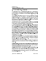
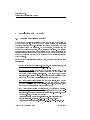
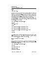
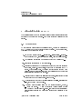
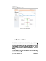
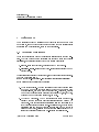
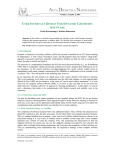
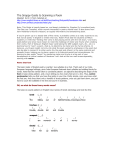
2 Architecture of the I2geo Platform
I2geo
is made of the following web applications which communicate but are
developed separately.
net/.
Curriki
All these components are deployed on
http://i2geo.
is a web application based on XWiki made for the collaborative cre-
ation of learning resources on the web mostly for one single server,
//www.curriki.org/.
?
http:
Curriki is distributed under the GNU General Public
License [ ] by the Global Education Learning Community non-prot company.
It is packaged as a java-servlets web application depending on a storage in
MySQL. Curriki answers the requests made to the paths starting with
All of the features of Curriki are used in
xwiki/.
I2geo except some metadata properties
(the topic and education levels) and the search tool.
SearchI2G
is a web application based on Apache solr, an information re-
trieval web application. This application is delivered by DFKI GmbH, under
?
the Apache Public License [ ] and developed within Intergeo to approach crosscurriculum search.
SearchI2G mostly serves as back-end tool for the
I2geo
tunings of Curriki. It is packaged as a java servlet web application.
CompEd
?
is a web application based on the AppFuse framework [ ]. It aims
at the presentation and edition of the topics and competencies, which are the
entities used for annotations and search on
I2geo,
?
?
as explained in [ ] and [ ].
?
CompEd is delivered by DFKI GmbH under the Apache Public License [ ].
I2geo
Root
is a simple web application whose role is to store the static
parts outside of each of the individual web applications and to redirect requests
according to a map so as to honour old URLs and shorter URLs.
I2geo Root is
?
delivered by the Université Montpellier 2 under the Apache Public License [ ].
c Intergeo
Consortium 2008
Page 8 of 49
Deliverable D4.4
Platform's Administration Manual
static resources
competencies
MySQL
topics
CompEd
users
AppFuse
update
GeoSkills
ontology
reset from
ontology
Web Browser
& co topics
mp
view etencie
s/ed
s
its
Root
auto-completion
rendering
SearchI2G
ion
let
rendering
Curriki
s
ge
pa es
riki urc
cur reso
d
an
users
MySQL
Velocity
Web Browser
c
to-
au
resources
p
om
groups
Groovy
web-content
RSS, LOM, , HTML, OM...
other web
consumers
Figure 1: Overall Architecture of the
c Intergeo
Consortium 2008
I2geo
Platform
Page 9 of 49
Deliverable D4.4
Platform's Administration Manual
2.1 The Curriki Web-Application
The Curriki system is an XWiki application: it builds on the XWiki architecture
by extending it for the purposes of exchanging learning resources and coordinating communities. The extensions are at several levels: user-interface, control,
and back-end.
The XWiki model underlying it is that of a java web application with dataobjects accessed in memory and stored in SQL databases through the Hibernate
?
persistance layer [ ]. The XWiki platform is based on documents which have
a title and a body (in many languages). It oers a type-system where objects
can be attached to documents and be specied by classes (which are special
documents) which describe property names and ranges.
This ability is at the heart of XWiki, and is described well in the XWiki tutorial.
It has been used to allow the edition of
traces in the rst steps phase of Intergeo
(where traces are simple records relating the title, license, etc).
XWiki documents are, as in any wiki, editable text-pages. XWiki documents are
grouped in spaces. Each space has a home page called
WebHome.
Pages delivered
by XWiki applications are made by the delivery of side-content, considered to
be the inclusion of a few panels, and the delivery of the main body, considered
to be the rendering of the text page; each delivery is done along an action.
The rendering process is the execution of a script in the Velocity template
?
?
language [ ], combined, possibly, with Groovy fragments [ ]. The execution of
these rendering scripts is done with a few variables available in their context,
such as information about the current-user, access to the document and its
attached objects, to the current-action (view, save, inline-edit, edit....), to other
documents, or to many other java objects (the core objects are documented in
?
the public API of XWiki [ ].
Curriki leverages this infrastructure by a very large set of velocity macros, which
is loaded in memory at start time. Most wiki pages in Curriki are made of objects
and their wiki-text is a mere call to these macros. The macros of Curriki are
?
documented in a form close to javadoc [ ].
Curriki also provides a few extra java classes which allow ner coding than
Velocity or Groovy; they are provided in the form of plugins. Their list can be
?
browsed [ ].
Central in this structure is the notion of Curriki asset which corresponds to an
educational resource. The Asset XWiki object contains all the generic metadata
information that all resources should be annotated with. It has been extended
by several properties specic to the Intergeo metadata.
Asset-types are numerous and keep being expanded. In a future release of Curriki and subsequent of
I2geo,
special asset-types for each interactive geometry
applications will be oered taking care of the individual renderings.
The Curriki asset-types has several sub-types for each of the elementary natures
of the resources, notably:
c Intergeo
Consortium 2008
Page 10 of 49
Deliverable D4.4
Platform's Administration Manual
•
external assets, aka, hyperlinks
•
uploaded les
•
collection assets, which contain other assets
The asset-class and sub-classes are not only XWiki classes but also java classes
whose methods allow an easy access to the properties both for setting and for
1
writing.
Another set of objects of importance to Curriki is a
community of users focused on a particular topic.
group,
which represents a
In their space, the groups
host communication through a web forum, documentation-oriented resources,
and learning materials, all packed within a space with its own history.
The Velocity scripts distributed by Curriki as well as the XWiki rendering infrastructure use these objects in order to generate user-interface language code that
the web browser renders.
Mostly, the XWiki infrastructure generates HTML
pages made of:
•
the header-bar containing titles and login-status
•
panels for the navigation menu and highlights
•
the main body, be it a resource display, a list, reviews or group documents.
The HTML pages embed a large amount of Cascading Style Sheet les and use
JavaScript to provide client automation. The style-sheet les are made of XWiki
and Curriki style les with a few
I2geo
adaptations directly done on les.
The Javascript les are based on a few JS libraries, such as yui, jquery, and ext-
?
js. They also include code generated by the Google Web Toolkit [ ] which is
particularly used for the Currikulum Editor and for the auto-completion features
described below.
?
The JavaScript tools communicate with the server through a Restlet API [ ],
allowing for example a le to be uploaded on a temporary document before it
is annotated with metadata, or the search results to be read.
2.2 Adaptation Strategies from Curriki to I2geo
Below, we shall describe the other web applications that constitute the
I2geo
platform. This simple co-existance is not enough to perform all the functions of
I2geo,
and adaptations to the Curriki UI and object-model are needed.
The adaptation strategy is that of patching an existing source:
release of Curriki, the version called
EOU 2
based on a
in the present case. The following
adaptations were performed:
1 These
objects
are
obtained
from
the
Curriki
xwiki.getPlugin("curriki").fetchAsset("space.name").
c Intergeo
Consortium 2008
plugin
using
a
call
such
as
Page 11 of 49
Deliverable D4.4
Platform's Administration Manual
•
the add-a-resource second panel, the Currikulum Editor, the Restlet server
interfaces, the asset XWiki classes have been adjusted to replace the input
for topic and educational levels by inputs of the SearchI2G web application, using entity designation through auto-completion
•
the rendering templates of resources have been adjusted to display these
and the quality framework result
•
the display of lists of items (such as the RSS and recent resources) has
been adjusted to t
•
I2geo's
another tab has been added to the display of resources to link to the
quality reviews, the whole quality framework has been injected as a new
space into the
•
I2geo
platform
the translation-bundles, scattered in several places in XWiki have been
centralized in the
Translations
space allowing an almost unied man-
agement of the translators work
All
•
A LOM-XML view of each resource has been provided
•
editorial adaptations have been done and keep being done
application
changes
are
stored
as
modied
les
within
the
subver-
http://svn.activemath.org/intergeo/Platform/
i2gCurriki. The quality framework is stored in its own space http://svn.
activemath.org/intergeo/Platform/QualityFramework.
sion repository of intergeo
The editorial changes as well as the translation eorts and congurations
are only maintained in the database of
XML backup format checked in in
Platform/i2gCurriki
I2geo.
They are exported to their
http://svn.activemath.org/intergeo/
before upgrading.
See below section 3 for the details on source availability and installation instructions.
2.3 The Intergeo Search Tool
This web application responds at the URL
SearchI2G,
its main function is to
maintain an index of both the terms of annotations of resources that live inside
the ontology as well as the annotated resources.
In its auto-completion function, the SearchI2G tool is called Skills-text-box, it
?
edits a list of nodes of the GeoSkills ontology [ ]. It can be embedded within
web pages or called in a pop-up, updating a hidden form eld.
In its rendering function, the SearchI2G tool renders a comma separated list
of GeoSkills identiers to HTML with appropriate languages. This function is
used in the rendering of resources and lists in the Curriki part of
I2geo.
c Intergeo
Page 12 of 49
Consortium 2008
Deliverable D4.4
Platform's Administration Manual
The maintenance of the index of this part is made by a call to the full-indexcreation (which takes approximately 2 minutes as of 01022009) or through the
reception of XML documents indicating updates such as the ones the ontology
server of CompEd receives (see below).
Both direct and auto-completion rendering present the nodes of GeoSkills with a
link to a presentation of them provided by CompEd for topics and competencies
and, currently, to the OWLdoc output for educational levels.
The suggestion feature of GeoSkills is built-in in these editors and les new
documents on the
Suggestions
space of Curriki.
In its search function, the SearchI2G tool renders a list of resources matching
the query. Its index is updated by regular notications of documents' saves in
the Curriki part of
I2geo
and the reading of the resource rendering as well as
the LOM record.
See below section 3 for the details on source availability and installation instructions.
2.4 The Competency Editor and Ontology Update Server
The CompEd web application is a web application whose role is to edit the topic
?
and competency nodes of GeoSkills. It is described in technical details in [ ].
The competency editor oers simple browsing of topics and competencies, most
useful for users to navigate the structure of topics and competencies in order
to identify by navigation the best term to search and annotate with. A simple
feature of SearchI2G's auto-completion code allows this choice to be owing into
the last visited Skills-text-box.
See below section 3 for the details on source availability and installation instructions.
2.5 The I2geo Root Web-Application
This web application is very simple. It has only two functions:
•
redirect requests that are issued to it so as to support short URLs (such
http://translators.i2geo.net/) or older
http://inter2geo.eu/). A table of
these redirects can be seen on http://svn.activemath.org/intergeo/
Platform/RootWebapp/src/main/webapp/WEB-INF/web.xml
as the groups names, e.g.
URLs (such as those stored before on
•
static le service for an amount of les is ensured there as well, simply
using the Apache and Tomcat infrastructure for le-serving
See below section 3 for the details on source availability and installation instructions.
c Intergeo
Consortium 2008
Page 13 of 49
Deliverable D4.4
Platform's Administration Manual
2.6 Interface of I2geo to External Web-Services
The web nature of
I2geo
is rich.
As much as possible, each user action is
traceable in the history and each state view is bookmarkable.
This feature,
although it was not made explicit in the quest for a platform, is of crucial
importance for the `referenceable web', a web that can be talked about and
?
spidered as hinted about in [ ]. This feature is often lost in applications of the
sort
rich-internet-applications.
As of today, the following web interoperability possibilities are allowed for external to integrate with
Web Robots
I2geo
on the web.
web spiders can simply follow links present in web pages and
will see all non-private content doing so. For the sake of a faster update pace,
an XML
Sitemap [?] is made available.
The Google robot seems to use it every
3 days.
RSS Syndicators
The RSS format is a simple XML-based encoding for dated
streams of activity. RSS streams of three avours are available in
•
I2geo:
the life of groups is tracked in the group stream. It describes the changes
in a group's documents, set of resources, or forum posts.
•
a list of all recent resources is displayed as the default RSS feed of this
web site
•
the list of all changes is available under that same URL to registered
administrators
All three kinds can be subscribed to (the administrator one requires one to add
the login information) and has been tested with Safari, Apple Mail, NetNewsReader, FireFox, and Google Reader.
Future: Metadata Crawler
Both LOM and RDF fragments can be ob-
tained about each resource, for the description of the metadata. Once a suitable
?
?
way is found, such as GRDDL as followed in [ ] or RDFa [ ], links from the
resource renderings to the records will be presented.
The current team of
I2geo has not yet found a sucient amount of consumers
of such metadata, be it at least to assess the extent of the interoperability.
Future: MetaBlogger
?
The MetaBlogger protocol [ ] is a simple protocol
used by blogging server to receive blog uploads from desktop applications. This
protocol should be used in order for interactive geometry desktop systems to
upload the resources directly on
I2geo,
with a possible metadata form screen
after the post.
c Intergeo
Consortium 2008
Page 14 of 49
Deliverable D4.4
Platform's Administration Manual
3 Installation and Upgrade
3.1 Common Installation Practice
Most of the web applications described below are built from source using the
?
maven 2 build tool [ ].
It is common to maintain a single web application
container where all the web-applications are running even though they only
communicate through web interfaces. On the le system, a directory is made
of this web application container, and a building space aside.
The building
space contains a checkout from the subversion of each project (detailed in the
installation instructions); a deployment is then made by the copy of the directory
of the web application produced by the build into the web application directory
of the container.
In order to run the installations described below, one needs the following prior
installations:
•
•
a Java Development Kit version 1.6 or above. For several platforms, this
can be downloaded from
http://java.sun.com/.
the Tomcat web server:
one needs to have Java installed rst.
Then,
one only needs to unpack the binary distribution of Tomcat (one can
http://tomcat.apache.org). Once it is done, the script
bin/startup.sh starts the server. You should then see the initial Tomcat
page at the URL http://localhost:8080 in your browser ;
get it from
•
the Maven project builder (version 2):
very easy install, same as with
Tomcat above, i.e., it depends on Java, and one only needs to download
the binary distribution from
the command
•
bin/mvn
http://maven.apache.org/, unpack it, then
should work out of the box ;
the MySql database (version 5 at least): here, we will sketch MySql's in-
http://www.
washington.edu/computing/web/publishing/mysql-install.html as
stall procedure, by means of using the version provided at
an example. First, download the tarball:
/home/henri>wget http://www.washington.edu/computing/web/
publishing/mysql-standard-5.0.27-linux-i686.tar.gz
/home/henri>untargz mysql-standard-5.0.27-linux-i686.tar.gz
c Intergeo
Consortium 2008
Page 15 of 49
Deliverable D4.4
Platform's Administration Manual
/home/henri>mv mysql-standard-5.0.27-linux-i686 mysql ; cd
mysql
/home/henri/mysql>_
Then, run the install script:
/home/henri/mysql>./scripts/mysql_install_db
...
/home/henri/mysql>_
Next, one must edit the
.my.cnf
le, which has to be located in the
homedir of the user owning the database (i.e., in the '' directory, namely
/home/henri
in our current example).
Basically, the
.my.cnf
congu-
ration le contains information about where the le socket MySql needs
to communicate with its clients should be located, and where the MySql
software and its data les (i.e.:
the main database) should be located.
Given what we showed above, a possible
.my.cnf
could be:
[mysqld]
port=3306
socket=/tmp/mysql.sock
basedir=/home/henri/mysql
datadir=/home/henri/mysql/data
[client]
port=3306
socket=/tmp/mysql.sock
Finally, one should launch mysqld and initialize the root password:
/home/henri/mysql>./bin/mysqld &
/home/henri/mysql>./bin/mysqladmin -u root password
'passRoot'
...
/home/henri/mysql>_
If everything went correctly, you should now be able to enter in an interactive session and run some commands, e.g.:
/home/henri/mysql>./bin/mysqld max_allowed_packet=32M &
/home/henri/mysql>./bin/mysql -u root -p
Enter password: ...
Welcome to the MySQL monitor.
c Intergeo
Consortium 2008
Page 16 of 49
Deliverable D4.4
Platform's Administration Manual
Commands end with ; or \g.
Your MySQL connection id is 1 to server version:
5.0.27-standard
Type 'help;' or 'h' for help. Type 'c' to clear the buffer.
mysql> use mysql;
mysql> create table People (Nom VarChar(255),Prenom
VarChar(255));
mysql> Insert into People Values ('Lesourd','Henri');
mysql> Insert into People Values ('Libbrecht','Paul');
mysql> select * from People;
+-++
| Nom
| Prenom |
+-++
| Lesourd
| Henri |
| Libbrecht | Paul
|
+-++
2 rows in set (0.00 sec)
mysql> quit;
/home/henri/mysql>_
For the case of the current installation at DFKI, a SuSE Linux server, the
platform2
sion 6.
directory contains the servlet container, the Tomcat server ver-
0.18 from the Apache foundation (http://tomcat.apache.org/).
platform2 directory also contains a buildingSpace directory with
curriki-dev, SearchI2G, comped, comped-maven-plugin, RootWebApp as deThe
scribed below.
Our documentation only provides code snippets for the Unix
shells.
Monitoring is then done through the inspection of the log les. Mostly the single
log le of the servlet container is used thus far. In the current installation it is
the le
conf/catalina.out.
Before installing, you might want to talk with the translations coordinator and
make sure you are going to compile with the last version of the translation les,
see page 41.
3.2 Installing Curriki
In this section, we describe the lower-level part (i.e.: installing the les, conguring the database and the container) of Curriki's installation procedure. The
next section describes the remaining parts which have to be performed manually,
along with the XWiki's import/export mechanism.
c Intergeo
Consortium 2008
Page 17 of 49
Deliverable D4.4
Platform's Administration Manual
To devise the install procedure below, we used information from the following
sources:
http://curriki.xwiki.org/xwiki/bin/view/Main/I2GcurrikiBuild
http://curriki.xwiki.org/xwiki/bin/view/Main/
InstallationInstructions
http://dev.xwiki.org/xwiki/bin/view/Community/Building#
HInstallingMaven
http://platform.xwiki.org/xwiki/bin/view/AdminGuide/
InstallationMySQL
We had to debug and to verify many things, for this information is error prone
and often incomplete.
But we had to start from there, for it was (mostly)
the only documentation available. We also had a look in mailing lists, to nd
workarounds for some bugs in the software components, which are (as much as
possible) described below (cf. section
To perform the task,
3.4.).
we provide an automated script.
You should rst
download the directory containing the installation script (i.e.:
activemath.org/intergeo/Platform/install/)
http://svn.
somewhere on your server.
To make things clear, let's say we want to perform the install in the directory
/home/henri/Intergeo.
Then we will proceed as follows:
/home/henri>mkdir Intergeo ; cd Intergeo
/home/henri/Intergeo>svn co http://svn.activemath.org/intergeo/
Platform/install
/home/henri/Intergeo>cd install
/home/henri/Intergeo/install>ls
configFiles install
/home/henri/Intergeo/install>_
The
install
script should be edited, to provide the following informations:
•
The directory where the install takes place ;
•
Tomcat's home directory ;
•
MySql's home directory ;
•
The password of MySql's root account ;
c Intergeo
Consortium 2008
Page 18 of 49
Deliverable D4.4
Platform's Administration Manual
If we suppose that Tomcat and MySql home directories are
and
/opt/MySql,
/opt/Tomcat/
respectively, and that MySql's root's password is 'passRoot',
then the rst lines of the install script (located at
install/install)
/home/henri/Intergeo/
should become:
#!/bin/bash
TOMCAT_HOME=/opt/TomCat
export TOMCAT_HOME
INSTALL_DIR=/home/henri/Intergeo/install
export INSTALL_DIR # Where you did unpack i2geo's install dir
MYSQL_HOME=/opt/MySql
export MYSQL_HOME PASS=passRoot # MySql's root password
Before starting the script, we need to have an instance of MySql running, with
the appropriate value of its parameter
max_allowed_packet
(this is necessary
because there are some cases where XWiki uses very big packets). Let's start
(or restart it):
/home/henri/Intergeo/install>cd /opt/MySql
/opt/MySql>bin/mysqld max_allowed_packet=32M &
...
We can now run the install script:
/home/opt>cd /henri/Intergeo/install
/home/henri/Intergeo/install>./install
...
Once it is nished, everything should (hopefully) have been automagically compiled and congured. To see if it really worked, let's rst restart Tomcat:
/home/henri/Intergeo/install>cd /opt/Tomcat
/opt/Tomcat>bin/shutdown.sh ; bin/startup.sh
...
If we point a browser to the URL
http://localhost:8080/xwiki,
we should
now be able to see Intergeo's homepage (it's okay if some parts are missing or if
some documents can't be found: we will solve this problem in the second part
of the install).
c Intergeo
Consortium 2008
Page 19 of 49
Deliverable D4.4
Platform's Administration Manual
3.3 Steps to perform manually
3.3.1 Importing some les
Once you successfuly installed the wiki, you should import a bunch of Currikirelated data in your system, by means of the XWiki's import mechanism (the
import and export mechanisms in XWiki are described in more detail below).
To do this, go to:
http://localhost:8080/xwiki/bin/import/Admin/Import (Note: to be on
/import and not on /admin (like it is described in some places on the Internet)
is important, for there is a bug in XWiki preventing success when you run the
import from
/admin/Admin/Import.
Thus the correct URL is the one above).
Then in Add an attachment , choose the le:
wiki/target/curriki-wiki.xar
as an upload le.
Once you click Attach this le , the page should take
some time (not more than one or two minutes, otherwise there is a problem, cf.
points (2) and (4) in
1.1.c.
above), and then reappear, with the le you just
uploaded in the list of Available les to import . If you click on it, the list
of its contained elements should appear under Available documents to import
. Then click the button Import to nally perform the import operation.
If everything goes well, you should then see the following error message:
Error: You are not allowed to view this document or perform this action.
To correct this problem, log in in the XWiki as user 'Admin', using the password:
'admin', and then go to:
http://localhost:8080/xwiki/bin/view/Admin/GiveProgRights,
and click
conrm .
Finally, you also need to import the les containing the (multilingual) messages
which are used by the Intergeo software. The related XAR le should be located
at:
http://svn.activemath.org/intergeo/Platform/Translations/
that's currently how we do it.
(Note:
In the future, we plan to automate this step
completely).
Once the translation les have been imported, they must be added to the list
Internationalization Document Bundles , located at the page under the
c Intergeo
Consortium 2008
Page 20 of 49
Deliverable D4.4
Platform's Administration Manual
link Programming on
/xwiki/bin/admin/XWiki/XWikiPreferences
(you
only need to do one declaration per multilingual page, rather than one declaration per language.
E.g.
given a multilingual page having the localizations
Translations.XWiki, Translations.XWiki:de, Translations.XWiki:es
and Translations.XWiki:fr, you only need to add Translations.XWiki to the list).
Congratulations! You installed the basic Intergeo platform successfully!
3.3.2 About XWiki's import/export mechanism
One important problem in wiki systems (at least, this is how things are in
XWiki) is their use of an opaque system (i.e., a database) to store the pages
and, more generally, various other kinds of data (e.g., scripts).
mechanisms for
exporting
importing in the wiki (e.g.
data outside of the wiki (e.g.
That's why
for backup) and for
for installing) are necessary.
3.3.2.a The XAR le format
In XWiki, the XAR le format is used for the purpose of exporting and importing data. As a matter of fact, a XAR le is a JAR le, containing a bunch of
XML les (one for each page contained in the XAR), plus a
package.xml
le
containing the list of all the les contained in the XAR.
package.
xml le has been created), a simple 'jar cf' command is sucient. For example,
given the two XML les A and B, which store the content of the two pages A
Thus it follows that to create a XAR le (and provided the appropriate
and B on the XWiki, we only need to put these two les in a directory (e.g.,
'tmp'), plus the related
package.xml
le:
/home/henri/tmp>ls
A B package.xml
/home/henri/tmp>_
Once the appropriate 'jar
cf'
command has been run:
/home/henri/tmp>jar cf ab.xar package.xml A B
/home/henri/tmp>_
we obtain a XAR le suitable for importing the pages A and B in another
XWiki:
/home/henri/tmp>ls *xar
c Intergeo
Consortium 2008
Page 21 of 49
Deliverable D4.4
Platform's Administration Manual
ab.xar
/home/henri/tmp>_
It should be noted that the structure in the directory 'tmp' above mimics the
structure of XWiki's naming, i.e., the pages are supposed to appear under
/xwiki/bin/view/
on the XWiki server where they will be imported (same
F1 located in the directory tmp/Dir1
/xwiki/bin/view/Dir1/F1 on the server).
rule applies for directories, e.g. the le
would represent the URI
The le
package.xml
must contain an entry per le, otherwise the les having
no entries are ignored by the import mechanism. Thus in our example above,
our
package.xml
could look like:
<?xml version="1.0" encoding="utf-8"?>
<package>
<infos>...</infos>
<files>
<file defaultAction="-1" language="">A</file>
<file defaultAction="-1" language="">B</file>
<file defaultAction="-1" language="">Dir1.F1</file>
</files>
</package>
(Note: please observe the notation 'Dir.F1' above, which would lead to a page
located at 'Dir/F1' on the XWiki. As far as we understood it, it's not possible
to add more levels, e.g.,
Dir1/Dir2/F1
is not possible).
3.3.2.b The xwikidoc XML dialect
Finally, the content of one le is an XML-based format describing the page, i.e.,
its content plus the metadata. For example, here is one of our translation pages,
called 'Translations.XWiki':
<?xml version="1.0" encoding="utf-8"?>
<xwikidoc>
<web>Translations</web>
<name>XWiki</name>
<language>fr</language>
c Intergeo
Consortium 2008
Page 22 of 49
Deliverable D4.4
Platform's Administration Manual
...
<creator>XWiki.segido</creator>
<author>XWiki.segido</author>
...
<content>1 <h1>Translations, Francais</h1>
<pre>
#side panel
panel.navigation.home= HOME
panel.navigation.home.rollover= I2geo - Géometrie Interactive
...
</content>
</xwikidoc>
As can be seen, although it's not extremely hard, there is still some work to
do to create such XML les from their content only.
Usually, such les are
obtained by means of exporting data out of an XWiki. The obtained XAR le
can be unpacked by means of a 'jar
xf'
command, and its
package.xml
can
be edited, to create a smaller XAR from it.
3.3.2.c Exporting data out of an XWiki
The
export
function
XWikiPreferences
available
from
the
URI
/xwiki/bin/admin/XWiki/
of any XWiki install can be used to export the whole con-
tent of the XWiki. Although useful, this function is not very precise (not only
does it exports mostly everything, but there are some pages it doesn't takes into
account).
For performing our own exports, we used the more congurable Groovy script
available at:
http://svn.xwiki.org/svnroot/xwiki/curriki/tags/curriki-1.2.0/
wiki/src/main/resources/Admin/ExportPageList
This script takes an XWiki page containing the exact list of the pages to be
exported, and creates the XAR le accordingly.
We will not discuss this topic of XWiki's export in more detail. But we had to
mention it, for it clearly appears to us that without using a (perhaps customized)
version of the
ExportPageList
script pointed out above (or a similar script),
no serious backup policy could be implemented: thus it's really important to
know that it exists.
c Intergeo
Consortium 2008
Page 23 of 49
Deliverable D4.4
Platform's Administration Manual
3.4 About the install script
(aka: if it doesn't work... )
The Intergeo platform is developed on top of a software stack which, although
robust and implementing standard technologies, is in many respects not very
well polished (i.e.: the components depend on many things, and their interfaces
are not always well dened).
Furthermore, part of the software is still under
development while we are writing this documentation.
This is why in the list below, we summarize a bunch of important things we
observed while developing the installation procedure (which are very useful to
know if it fails at some point):
pom.xml les (especially: curriki/pom.xml, curriki/
web/pom.xml, curriki/gwt/pom.xml), there are version values with
'SNAPSHOT' inside: it means that we rely on beta versions to perform
1. In the various
the build.
Given how Maven operates (i.e.: by means of automatically
downloading the packages from remote repositories), we can be sure that
once the stable versions will appear (in such a case, the 'SNAPSHOT'/beta
versions disappear from the servers), the Maven build will break.
There is no solution to this problem, except banning the practice of using
beta versions in the builds. It turns out that the developers of the software
components which wrote the
pom.xml les we depend on do not honor this.
Currently, we removed as much as possible of these 'SNAPSHOT' dependencies, but some remain, because the stable versions do not exist.
Once
these stable versions will be available, the related dependencies to their
beta snapshots should be corrected (removing the 'SNAPSHOT' substring is
sucient, Maven does the rest) ;
2. The Java-based implementation of XWiki is extremely dependent on the
initial memory conguration of the JVM, which should be congured with
the options '-Xms512m
OPTS
and
JAVA_OPTS
-Xmx2048m' when starting Tomcat (see CATALINA_
bin/catalina.sh).
in
This is automatically done by the install, but in case one observes extremely long delays while loading a page (i.e.
several minutes), it can
be related to memory exhaustion in Java. To know what's going on, the
les
logs/catalina.out and logs/localhost*.log are very useful, they
contain all Java error and log messages ;
3. The XWiki does not always start, it can be that you only get a blank page,
or that it starts but that later some operation (e.g.
importing a XAR
le) repeatedly fails. In such circumstances, we observed that restarting
Tomcat can help. We also met some situations where it was not sucient,
while rebooting the machine solved the problem ;
4. When importing XAR les, it seems that the Lucene indexer comes into
play. If for some reason it cannot nish his job, the database can become
c Intergeo
Consortium 2008
Page 24 of 49
Deliverable D4.4
Platform's Administration Manual
corrupted. This is a very vicious kind of error, because such corruption
problems do not always appear explicitely (i.e.:
you still can boot the
wiki, everything looks ne, while in fact, one portion of the database is
corrupted, preventing you from performing some operation, e.g., nishing
an interrupted XAR import, or removing the corrupted XAR).
In such circumstances, we found that the only reliable way to get rid
of the corrupted data is to erase everything and redo the whole in-
including deleting the MySql les where the database
is physically located (i.e., delete everything in mysql/data, then redo
stall from scratch,
scripts/mysql_install_db,
password 'passRoot', then run the
the
bin/mysqladmin
plus
whole
install
-u root
script once again).
There are also other ways how the database can become corrupted. In any
case, to our knowledge, the receipt that works is the one we just sketched.
Another related problem is that in current versions of MySql, the 'drop
user'
command does not always work properly. Thus if you simply drop
the user 'xwiki' and create a new one having the same name (e.g., because
you forgot the password...), it won't work (i.e.: the 'drop
can fail: please have a look in the
install
user' command
script to see how it's done ; of
course in such a case, you also have to redo the related
grant
command)
;
Finally, here is a list of some important cong les you could have to edit
and/or to watch in order to tune and/or to supervise your newly installed system
(the install works well for running an instance of XWiki/Curriki at
localhost:8080.
But for things like, e.g.
http://
changing the hostname, changing
your database's password, etc., you have to edit the cong les):
i. the
ii. the
~/.my.cnf,
which is MySql's main cong le ;
~/m2/settings.xml, which is Maven 2's main cong le ; this le is
install script, and you need it this way to be able to compile
set by the
Curriki ;
xwiki.cfg le, located in web/target/curriki-web-1.0-SNAPSHOT/
WEB-INF/xwiki.cfg. You need to edit this le to congure XWiki, e.g.,
iii. the
setting the hostname, conguring the indexing, and various other things ;
hibernate.cfg.xml le, located in web/target/curriki-web-1.
0-SNAPSHOT/WEB-INF/hibernate.cfg.xml. This le describes your
iv. the
database, especially the username used to connect to the database, and
the password.
It coheres with the related part in the
install
script,
where we create a database called 'xwiki', and a user 'xwiki@localhost',
having the password 'xwiki1234'.
It should be noted that in spite of the notation, this MySql user
does not
corresponds to a user on the server (i.e.: there's no need to create the
c Intergeo
Consortium 2008
Page 25 of 49
Deliverable D4.4
Platform's Administration Manual
same user with the same password on your server, it has absolutely no
eect) ;
v. the le
bin/catalina.sh
in your Tomcat installation: this is the script
responsible for starting the container, and especially, for tuning the JVM's
memory size ;
vi. the log les
logs/catalina.out and logs/localhost*.log in your Tom-
cat installation are very useful, they contain all Java error and log messages ;
3.5 Installing other Web-Applications
As is the case for Curriki, the other web applications of
I2geo are all built using
the maven 2 system. The following simple mechanism thus applies to build and
install them.
3.5.1 Installing the Root web application
Within the build directory, checkout:
svn co http://svn.activemath.org/intergeo/Platform/RootWebapp/
It may be worth reviewing
Then, from the
RootWebapp/src/main/webapp/WEB-INF/web.xml.
RootWebapp
directory that has just been created:
mvn package
which creates a directory called
root which is the web application.
That appli-
cation should be installed at the right place to answer to queries to the paths
without a web application (in Tomcat, this is done by the usage of the name
ROOT and leaving it in the
webapps
directory, thus we do:
rsync -avc target/root/ ../../tomcat/webapps/ROOT/ --dry-run
to rst see the les aected; then, once conrmed:
rsync -avc target/root/ ../../tomcat/webapps/ROOT/
A directory
static
should then also be created as a separate webapp:
cd ..
svn co http://svn.activemath.org/intergeo/Platform/static/
and copied to the appropriate directory
rsync -av static/ ../tomcat/webapps/static/
More documentation about the root web application of
tained from
README.txt.
c Intergeo
I2geo
can be ob-
http://svn.activemath.org/intergeo/Platform/RootWebapp/
Consortium 2008
Page 26 of 49
Deliverable D4.4
Platform's Administration Manual
3.5.2 Installing CompEd and onto-Update server
CompEd is made of three modules, the CompEd web application itself, the
CompEd maven plugin, and the ontoUpdate server. Before installing, you might
want to check with the translators coordinator what the status of the CompEd
bundle is, see page 41.
CompEd Maven Plugin
Check out comped-maven-plugin and rst install
it (in the local maven repository):
svn co http://svn.activemath.org/intergeo/Platform
/comped-maven-plugin/
cd comped-maven-plugin
mvn install
OntoUpdate Server
Checkout the ontoUpdate server:
svn co http://svn.activemath.org/intergeo/Platform/ontoserver/
build it (the testing part of
ontoserver
):
cd ontoserver
cd updateCoder
mvn install
cd ../web
mvn package
deploy it:
rsync -av target/ontoUpdate/ ../../../tomcat/webapps/ontoUpdate/ --dry-run
to rst see the les aected; then, once conrmed:
rsync -av target/ontoUpdate/ ../../../tomcat/webapps/ontoUpdate/
Within the application server directory, a directory called data will be written
to.
For safety we create that directory with a subversion snapshot which we
expose on the web:
cd ../../../tomcat
cd webapps
svn co http://svn.activemath.org/intergeo/ontologies/
cd ..
ln -s webapps/ontologies data
c Intergeo
Consortium 2008
Page 27 of 49
Deliverable D4.4
Platform's Administration Manual
CompEd Web Application
Checkout the CompEd web application:
svn co http://svn.activemath.org/intergeo/Platform/comped/
cd comped
pom.xml: in particular the database
mysql-prod need to be adjusted based on a
Then edit the settings contained in the le
connection properties of the prole
database you allocate for CompEd to work.
The properties in the
prod
and
prod-repopulate
proles should also be ad-
justed to contain the paths:
• comped.ontologyURL:
the path from which the ontology is loaded at re-
population (per default the svn path)
• comped.sync.destinationURL:
the path to which to send the XML doc-
uments describing the updates (this is the URL of the ontoServer that has
been installed above)
• comped.sync.responseURL:
the URL to which the ontoUpdate server
should send the response
• comped.searchI2G.server:
the other URL to send the XML documents
describing the updates
• comped.searchI2G.browserPath:
the host-relative path to the javascript
of the skills-text-box routines
Then build the table digest of the ontology:
mvn comped:gs2comped
and populate the database:
mvn -Pprod-clean-repopulate,mysql-prod clean package
Then deploy the web application:
rsync -av target/comped-1.0-SNAPSHOT/ ../../tomcat/webapps/comped/ --dry-run
to rst see the les aected; then, once conrmed:
rsync -av target/comped-1.0-SNAPSHOT/ ../../tomcat/webapps/comped/
3.5.3 The Intergeo Search Tool
The Intergeo Search tool is a simple web application built from several maven
modules.
Checkout and build:
c Intergeo
Consortium 2008
Page 28 of 49
Deliverable D4.4
Platform's Administration Manual
cd ../buildingSpace
svn co http://svn.activemath.org/intergeo/Platform/SearchI2G/
cd SearchI2G
mvn install
(currently, Linux, Windows, and MacOSX are supported, depending on the
management of temporary les
clean install)
mvn install
may need to be replaced by
mvn
Then deploy the web application:
rsync -av web/target/i2geo-search-web-1.0-SNAPSHOT \
../tomcat/webapps/SearchI2G/ --dry-run
to rst see the les aected; then, once conrmed:
rsync -av web/target/i2geo-search-web-1.0-SNAPSHOT \
../tomcat/webapps/SearchI2G/
3.5.4 The Search Tool's XWiki Plugin
Having done this, we need to move around jar les for the class static members
to be shared between web-applications allowing macros to be called.
This is
done by moving an amount of jar les to the shared web-application-container
directory.
We start within the tomcat directory and consider its shared jar
directory called
lib.
cp ../buildingSpace/SearchI2G/api/target/i2geoAPI-1.0-SNAPSHOT.jar lib/
cp ../buildingSpace/SearchI2G/xwikicomponent/target/\
searchi2g-xwiki-component-1.0-SNAPSHOT.jar lib/
cp ~/.m2/repository/com/google/gwt/gwt-servlet/1.5.3/gwt-servlet-1.5.3.jar lib/
Although this should be automatically done, you may wish to verify that none
of the jars that we have moved actually is within the
Finally,
the
plugin
can
be
activated
webapps/xwiki/WEB-INF/xwiki.cfg
net.i2geo.xwiki.SearchI2GXWikiPlugin
after
CurrikiActivityStreamPlugin.
the
c Intergeo
Consortium 2008
webapps
by
the
a
directory.
adding,
in
class-name
comma
after
Page 29 of 49
Deliverable D4.4
Platform's Administration Manual
4 Editorial Activity on I2geo
The editorial activity on
I2geo consists of all the edition tasks for static pages
as well as the management of users.
Both these topics are presented in this
section.
4.1 XWiki Syntax
XWiki pages are written using a particular syntax, which is an extension of
HTML. Velocity and Groovy scripts can also be present. As an introduction,
these may be most often used codes:
__underline__, ~~italic~~, --strike--,
<tt>monospace</tt>, <sup>superscript</sup>, <sub>subscript</sub>.
i. Use of text modes: **bold**,
ii. The beginning of a list item is a newline marked with a single * or -.
iii. Paragraphs are separated by two blank lines.
iv. Headers are constructed by just starting a line with numbers separated
with points, as in 1.1 Level 2 title", which would be equivalent to HTML
<h2>1.1 Level 2 title</h2>". To insert a header of level 2 and let XWiki
decide which numbering it should have, just use
==;
the number of equal
signs indicates the level of the header.
v. A link is denoted by [pageName]"; a link with a label, [label>pageName]"
where pageName can be either space.page or page.
vi. A table starts and ends with {table}"; cells start with |", title cells with
|=", and rows end with a newline.
vii. A velocity macro is called using the #macroname(param1, param2,
...,
paramN)"
syntax.
A
list
of
available
Curriki
velocity
macros
http://curriki.xwiki.org/xwiki/bin/view/Design/
CurrikiVelocityAPIs; you don't need programming privileges to use
can be seen at
them!
c Intergeo
Consortium 2008
Page 30 of 49
Deliverable D4.4
Platform's Administration Manual
viii. XWiki macros are called using the {{macroname param1="value1" ...
paramN="valueN"
}}"
HTML constructs.
A useful macro is {pre} which avoids the execution
syntax.
They are useful to create particular
of the XWiki syntax for the included part.
ix. Through Velocity (and Groovy), data from Java objects can be read and
methods be called. In velocity one uses
$varName
to refer to a variable,
while in Groovy the simple variable name is used; for example, to obtain
the full name of the user.
The properties and function names available
?
can be seen in [ ].
x. A Velocity script can be anywhere in the text, it starts with the # sign,
for example #set ($var =
"whatever")".
?
See [ ] for a complete language
reference.
xi. A Groovy script between marks <% def var =
"whatever"
?
%>".. See [ ]
for more details about this language.
There are many more options; see, for instance,
xwiki/bin/view/Main/XWikiSyntax.
http://platform.xwiki.org/
Keep in mind that you can always use plain HTML, so that you don't really need to know this syntax to create new pages.
For instance, if some
day you have to insert a link somewhere, you could just resort to the classical
<a href="http://.../">text</a>.
4.2 Pages, translations, spaces and their management
In XWiki, les are grouped logically in spaces for better handling.
Localization is the
translation of a whole page, including images and links, as opposed to translaEach le can be translated into any of the languages.
tion of just a text. Localization of pages has particular subtleties. For instance,
in order for texts to t well into a page, sometimes they must have the right
length. Some entities which require customized formats are dates, times, currencies, titles (Mr., Ms.) and so on. Localizing entire documents fully respects
all these features, but runs a higher risk of becoming deprecated.
To avoid this, best practice indicates that pages that require an amount of programming be written without language and that pieces of language dependent
text are fetched from a
bundle,
a dictionary of phrases.
A bundle is a set of
property les, one le for each language; we will talk more about property les
in the next section.
Bundles belong in spaces. Bundle les belong in bundles or directly in spaces.
I2geo
bundles
bundles setup and dierences with Curriki:
are
c Intergeo
distributed
among
Consortium 2008
many
spaces,
related
to
In
the
Curriki,
application
Page 31 of 49
Deliverable D4.4
Platform's Administration Manual
development,
In
I2geo,
and
they
are
accessible
through
the
administration
page.
however, for the ease of translation, most of the bundles have
been moved to the Translations space, and they can
http://i2geo.net/xwiki/bin/view/TranslatableFiles/.
be
accessed
The
at
bundle
CurrikiGWTTranslations, which is used in the Currikulum editor, is loaded in
a particular way, and so, for the moment, it will have to be copied by hand
over to the old bundle accessed through the administration page (this will be
solved; see jira issue 273 at
http://jira.activemath.org/browse/IG-273).
Applications' bundles for CompEd and the Search tool are also loaded in
their own particular ways at compile time, and so the content of the les
accessed at the Translatable Files page will have to be copied over by hand
recompilation to the les in the directories intergeo/Platform/
comped/src/main/resources/ApplicationResources_xx.properties
or
intergeo/Platform/SearchI2G/api/src/main/java/net/i2geo/api.
before
How to create a page:
have (for instance,
use a browser to go to the address you wish it to
http://i2geo.net/xwiki/bin/view/MyPage/Here;
make
sure you are using English; click on the edit button with the pencil icon on the
top, left corner of the page; write something; save.
How to edit, rename, delete pages:
use a browser to go to the page and
use the buttons on the toolbar on the top of the page; this is only available if
you are in the administration group. You have also options to see the history
of a page, print it, and manage its attachments.
How to translate a page:
visit it, edit it, change the language using the
Warning: make sure
you are using the right language before saving, or you will modify the
combo box in the page header, modify it, and save.
wrong le.
How to edit a bundle le:
view the le, then click on the edit button with
the pencil icon on the top, left corner of the page. It is not advisable to use a
browser to go directly to its edition URL, because it's easy to make a mistake,
create a useless le, and then forget about it.
How to create a bundle le:
edit any le in the bundle, change the language,
and save. What you will save is a copy of the le with the default language for
the bundle, normally English.
How to create a bundle:
edit an existing bundle le, change its BundleName
Warning: make sure you are editing the
le in English when you save; otherwise, the default language of the bundle
to the name you desire, and save.
would not be English, and this would be undesirable for translators, who would
then not start with a copy of the English le.
How to see which bundles get loaded:
go to /xwiki/bin/admin/XWiki/
XWikiPreferences?editor=globaladmin§ion=Programming&skin=
toucan.
Space management:
go to http://i2geo.net/xwiki/bin/admin/XWiki/
XWikiPreferences?editor=globaladmin§ion=Programming&space=
c Intergeo
Consortium 2008
Page 32 of 49
Deliverable D4.4
Platform's Administration Manual
XWiki&skin=toucan,
and select the space in the Programming" combo box.
You can see a list of spaces at
ListAllSpacesinCurrikiminusGroups, and
http://i2geo.net/xwiki/bin/view/
you can see a list of pages in a space at
Admin/SpacePages.
4.3 Panel edition
In XWiki, panels are blocks of HTML code that are included in many pages.
Panels include the left menu (which is called Navigation panel) and other window areas such as the Sponsors" rectangle or the Table of Contents" section
that appears when viewing an asset.
If a panel has to be modied, go the Administration page and click on Panels"
in the XWiki Preferences" section; there you can nd options to create new
panels, and edit or customize existing ones.
4.4 XWiki groups and their management
An XWiki group is
not a group where users talk, as a Curriki group is, but rather
an administrative tool that allows some users to have some access privileges
(viewing, edition, erasure, etc) to some resources. Examples of XWiki groups
are administrators (have access to almost everything) and translators (have read
and write access to bundles). When it is desired that a user have some access
privileges, he is added to the corresponding group. Normal users cannot create
XWiki groups or even view them.
To manage XWiki groups, go to the Administration page, and click on Groups"
in the User Administration" section. Click on the group you want to manage,
and then on the Edit" button with the pencil icon on the top, left corner of the
add a new user, enter its username in the Add new user" textbox.
remove a user, click on the red cross next to its name. To create a new
XWiki group, enter its name in the Add new group" textbox.
page. To
To
To
modify
the
list
of
resources
that
a
group
can
access,
go
to
http://i2geo.net/xwiki/bin/admin/Translations/WebPreferences?
editor=spaceadmin§ion=Rights, select the space in the Rights" combo
box, and the group in the grid below (you might prefer typing the group name
in the text box). By ticking a checkbox in the grid, you grant the column access
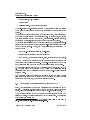
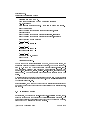
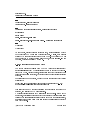
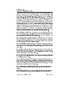
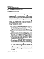
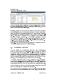
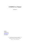
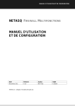
to the row group in all resources of the selected space as depicted in gure 2.
4.5 Curriki groups
A Curriki group is a tool for users to communicate. Users can create Curriki
groups. Belonging to a Curriki group only gives access to the group's resources.
c Intergeo
Consortium 2008
Page 33 of 49
Deliverable D4.4
Platform's Administration Manual
Figure 2: Editing Rights for a space
For more information on Curriki groups, see the
available at
I2geo
Basic User's Manual,
http://i2geo.net/xwiki/bin/view/Coll_curriki/Tutorials.
Normal users cannot delete Curriki groups, so occasionally you may receive a
request to do it; in this case, go to
GroupDelete.
http://i2geo.net/xwiki/bin/view/Admin/
Beware, this cannot be undone!
4.6 Activating, deactivating, and deleting users
Users can be activated, deactivated and deleted at
bin/view/Admin/MemberDelete.
http://i2geo.net/xwiki/
Deleting a user should always be a last-ditch
recourse, because it cannot be undone and can raise complications; it is preferable to deactivate his/her account.
Manual activation is sometimes necessary because the activation mail never
reached the user. It is done by the edition of the user's XWiki-object.
4.7 Managing CompEd users
Being a registered user at CompEd is separate from being a registered user at
I2geo.
This a known limitation which we hope users will accept.
Normal users in CompEd have no modication rights.
activated for the role of
curriculum encoder
Users can however be
translators who simply translates the names or to the role
who create and maintain all the topics and competencies.
The list of users and their roles can be managed in the Administration section
of the administrator user.
c Intergeo
Consortium 2008
Page 34 of 49
Deliverable D4.4
Platform's Administration Manual
5 Monitoring the website
5.1 Monitoring the server
The Administration page,
http://i2geo.net/xwiki/bin/view/Admin/,
con-
tains several easy to use tools to check the state of the server and perform some
maintenance operations:
1. Check
Server
Status:
RequestsStatus.
http://i2geo.net/xwiki/bin/view/Admin/
Memory
Status:
http://i2geo.net/xwiki/bin/view/Admin/
MemoryStatus, with options to perform garbage collection and ush cache
2. See
at garbage collection.
3. See
Requests
status:
RequestsStatus.
http://i2geo.net/xwiki/bin/view/Admin/
http://i2geo.net/xwiki/
bin/view/Main/WebRss?xpage=rdf, and to the blog RSS feed at http://
i2geo.net/xwiki/bin/view/Main/BlogRss?xpage=rdf.
In addition, you can subscribe to an RSS feed at
Being an administrator and issuing this request will show you all the changed
pages, while the normal RSS-reader-oriented feed does not. This provides an
ecient way to track all changes done by users such as the introduction of an
editorial change, the introduction of a quality review, or even of a temporary
le before the metadata input. Some browsers support the direct rendering of
RSS streams as web pages (as of today, Firefox and Safari if congured to be
the RSS reader).
Section 7.2, on Manual Maintenance, describes other operations related to monitoring the server which lead to maintenance actions.
5.2 Helping users
Administrators must often check the users mailing list to see whether there is a
user asking for help within reasonable limits. (Ignore homework help demands,
c Intergeo
Consortium 2008
Page 35 of 49
Deliverable D4.4
Platform's Administration Manual
spam, etc.) This list can be accessed at
Main/UsersMailingList.
http://i2geo.net/xwiki/bin/view/
Among other things, users can send bug reports to this list.
They could
also create jira issues, so that the administrators should check occasionally
whether there is a new issue at
http://jira.activemath.org/browse/IG. Jira
http://www.atlassian.com/software/jira/
documentation can be found at
docs/latest/.
In helping a user, it might be necessary to nd his/her account; use the user
search tool at
http://i2geo.net/xwiki/bin/view/Admin/UserSearch.
For
some questions, the easiest answer will be to refer her/him to the Basic User's
Manual, which is located at http://i2geo.net/xwiki/bin/download/Coll_
segido/I2geoBasicUserManual/BasicUserManual.pdf.
User accounts can be activated or deactivated at
bin/view/Admin/MemberDelete.
http://i2geo.net/xwiki/
5.3 Tracking (Google Analytics)
In order to analyze the behavior of users, an account for
I2geo has been set up
at Google Analytics (GA). It is a free account, which means it can track only up
to ve million visits per month, and we can congure only four goals (dened
below).
GA works by receiving notications sent each time an
I2geo
page is down-
loaded. All pages contain a script which sends a message to GA indicating their
URL and an anonymous user code; thus, GA can track what the users are doing. This data is analyzed nightly, and so it is not possible to see the eects of
changes on the web immediately . One problem with this approach is that some
pages on
I2geo do many things, and so it is not possible to know what the user
is doing just by looking at the URL; a good example is the Currikulum Editor,
which lets the user view, edit or comment on a resource within the same page.
(Note: this may change. At some point, changes in
I2geo's
Currikulum editor
may be introduced so as to provide GA with the necessary information).
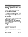
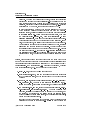
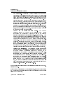
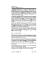
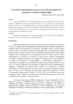
GA allows us to nd out which resource is visited most, how much time users
spend annotating, which websites are sending us visitors, which country they
are from, and what users are searching for, by storing what they enter in the
search boxes. By dening goals such as resource duplication, we could measure
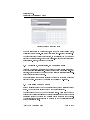
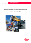
re-utilization of software. A sample report is at 3.
In GA lingo, a
goal is an operation detected when a user has gone through a
pre-determined sequence of URL's that have to be traversed in a xed order.
For instance, if the same user consecutively visits an ad page, a sales page, and
conversion;
objective is the place where we
an order conrmation page, the website has achieved a goal (or a
a visitor has been converted into a buyer). An
would like a visitor to go.
c Intergeo
Consortium 2008
Page 36 of 49
Deliverable D4.4
Platform's Administration Manual
Figure 3: A Google Analytics report for i2geo
access the I2geo's GA account, go to http://www.google.com/
analytics/, click on Access Analytics", and enter [email protected]" as
In order to
our gmail address; the password is the same as that of the superadmin account.
Our account code is UA-6685035-1".
To congure a goal, you should rst decide which URLs will dene it.
Click
on Analytics settings" (top, left corner), then in Edit" within the accounts
table (in our case there is only one row). In the section Conversion Goals and
Funnel" there are four goals, labeled G1 to G4. Decide which goal you are in-
Math type indicates how URL's are
goal URL is the address that, when visited, will indicate
that the goal has been achieved. The goal value is used to weigh" the relative importance of dierent goals; it can possibly be ignored. The obligatory
terested in, and click on its Edit" link.
to be processed. The
checkbox indicates whether a user has to go necessarily through the rst step
in order to complete the goal; this would be useful if, for instance, we wanted
to split buyers" into people who came to buy" and people who bought after
seeing the ad". Each step has a name and a URL; the goal URL is the nal
step", although it is not formally a step. A goal can have no steps, but it must
have a goal URL. Finally, click on "Save Changes" when you are done.
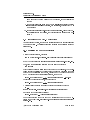
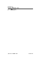
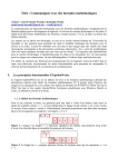
By clicking on funnel Visualization", a visual representation of the paths that
users have followed is displayed as in gure 4.
For more information on GA, see
index_en-US.html.
c Intergeo
Consortium 2008
http://209.85.139.110/analytics/tour/
Page 37 of 49
Deliverable D4.4
Platform's Administration Manual
Figure 4: Funnel visualization.
6 Translations Workows
Since translating a website is quite a time consuming task, and it is desirable that
I2geo be translated to many languages because of its project nature,
during the development of the platform it was decided to have a translations
coordinator to organize all the tasks related to translations, and to minimize
the time translators have to spend in organizing their work. These tasks can
be split in two groups: tasks for the translations coordinator, and tasks for the
translators.
It is quite possible that the website administrator and the translations coordinator will be dierent persons.
c Intergeo
Consortium 2008
Page 38 of 49
Deliverable D4.4
Platform's Administration Manual
6.1 Translations coordinator tasks
The translations coordinator has to:
•
Provide general support to translators; send them the Translator's
Manual and maybe the Basic User Manual too, answer questions about
character encoding, tell them URL's where things are, etc.
•
Save translators' time by organizing their tasks.
Working with property
les is time consuming and prone to committing little errors; before telling
translators to do something, do it yourself and see what complications can
arise, so that only one persons wastes time. Be precise when describing
the tasks to do; mention the les and the properties involved explicitly.
•
Manage the translators group
view/Group_Translators/).
(http://i2geo.net/xwiki/bin/
This is a Curriki group, and it has to be
checked occasionally for new messages.
•
Add new languages.
This involves:
to
http://i2geo.net/xwiki/bin/admin/XWiki/
XWikiPreferences?editor=globaladmin§ion=
General&skin=toucan, add the new language to the list, and
1. Go
save. Wait one night for the change to take eect.
2. Add the new language the in the Global Class Translations bundle, at
least in English (the other languages will have to have its translations
updated).
3. In order to add the new language to the skills-text-box, add the new
language in SkillsTextBox.gwt.xml as supported language, and then
send a mail to the wp4 mail list so that skills-text-box is recompiled.
4. In order to add the new language to the Currikulum Builder, edit
http://i2geo.net/xwiki/bin/edit/
CurrikiCode/AssetClass?editor=class, clicking on language,
XWiki.AssetClass by going to
modifying Values, and then on Save.
to
http://i2geo.net/xwiki/bin/edit/XWiki/
CurrikiSpaceClass?editor=class, click on the language tag,
and replace values with the result in http://i2geo.net/xwiki/
bin/view/XWiki/SupportedLanguages?xpage=plain&len=long,
5. Go
replacing spaces for pipe characters (|).
6. Add the two language codes in
view/Translations/Languages.
http://i2geo.net/xwiki/bin/
Note that his le is not translat-
able, since it contains the languages as they will appear in the language selection box, and so translators will not edit this le - the
translator coordinator has to do it. You will have to ask each translator how his/her language is written in his/her language to include
it in this le.
c Intergeo
Consortium 2008
Page 39 of 49
Deliverable D4.4
Platform's Administration Manual
•
Add new translators to the XWiki translator group.
This is the
group that allows translators to edit bundles without being administrators.
Note that translators must belong to both groups; they are responsible for
subscribing to the Curriki Translators Group, but an administrator has to
add them to the XWiki Translators group. Go to the Administration page,
in the User administration section click on Groups, then on Translators
Group. In order to modify the list, click on the Edit button on the top,
left corner.
•
Add a new banner.
The image with the Interoperable Interactive
Geometry for Europe text seen on top of the page header has to be
translated; this requires, for each new language, the creation of a new
image and an upload of it to the directory
/xwiki/skins/curriki8/.
There are two related properties in the Registration bundle:
## translatable slogan
header.slogan.png=/xwiki/skins/curriki8/i2g_slogan_en.png
header.slogan.alt=Interoperable interactive geometry for Europe
•
Perform Curriki updates
les).
date
If
Tool
les;
new
the
to
Curriki
les
automatically
entries
will
be
(the
are
parts
updated,
introduce
marked
the
with
that
use
aect
the
changes
a
translation
Translation
in
the
Up-
I2geo
-TRANSLATE-ME
http://www.curriki.org/xwiki/bin/view/Messages_
Group_CurrikiTranslations/TranslationUpdateToolDescription for
string.
See
details. The normal procedure would consist in the translations coordinator updating all the translations (this will require some amount of time),
sending the les with new entries to the translators, and checking that
they upload the revised les.
•
Keep a backup of translations.
Even though translators are likely
to keep copies of their work, and the website administrator is responsible for making backups regularly (see section 7.1 on Automated Maintenance), it may be a good idea that the translations coordinator keep
a copy of all the translation les.
may be dicult to contact.
on the
I2geo
Remember that some translators
A note of caution:
translators may work
les at any time, so you should always think of your
copies of the translation les as obsolete.
For the same reason, if you
add a new property to the les, tell the translators by leaving a message for the group and sending them an email, or else you risk them
overwriting your changes.
The language les are stored at directory
Platform/i2gCurriki/wiki/src/main/pages/Translations;
they can
be refreshed by running the script refresh-from-i2geo.sh.
•
Coordinate the work of developers and translators.
As developers introduce new improvements, new texts will have to be
translated. You are to coordinate both teams so that everybody can do
their work eciently and nish in time.
c Intergeo
Consortium 2008
Page 40 of 49
Deliverable D4.4
Platform's Administration Manual
New properties.
Occasionally it will be necessary to add some new
properties to the translation les; this could be caused by a Curriki developer or an
I2geo developer.
You have to add this property in the English
les. Quite possibly the developer will tell you in which le and in which
place within the le it should go; else, you will have to decide this. (The
property will work no matter where you place it, but it should be in an
easy to nd place). Consider adding some comment describing the context in which this property appears, so that it is clear whether it should be
translated in singular or plural, masculine or feminine, etc. Then send a
message to the Curriki Translators Group notifying the translators about
the new properties; this message should be very clear as to the le, location, property names, and comments, so that only one person (you) has
to spend time guring out these details.
CompEd and the Skills Text Box Editor.
bundle
its
is
building
loaded
(or
by
CompEd
compilation)
it
in
a
reads
The
particular
the
les
in
CompEd
way:
during
the
directory
src/main/resources/ApplicationResources_xx.properties.
This
means that the les that the translators can edit are not the ones that
CompEd reads; and, moreover, that changing the les in that directory
won't modify the texts shown by CompEd until the whole program is rebuilt again. When CompEd is going to be rebuilt, the person in charge
of this task should notify you in time, so that you can tell some translators to nish o that le, and then you should copy the les by hand
from the Translations space to that directory.
The same happens with
the Skills Text Box Editor, whose bundle is SKBi18n, and the les are in
intergeo/Platform/SearchI2G/api/src/main/java/net/i2geo/api.
CurrikiGWTTranslations.
The Currikulum Builder also loads its
property les in a particular way; concretely, it searches for them in
the bundle CurrikiGWTTranslations within the XWiki space, but the
translators edit the CurrikiGWTTranslations bundle within the Translations space, and so their changes will not be seen immediately. When a
modication is done by a translator, you should copy the corresponding le from the Translations space (accessible through the Translatable Files page) to the XWiki space (accessible through the Administration page, link GWT). Unlike for CompEd, no recompilation is necessary, and so the changes will be visible immediately after copying the
le.
This problem will be solved at some time; see jira issue 273 at
http://jira.activemath.org/browse/IG-273).
Some of these tasks will require that the translations coordinator be an administrator of
I2geo.
If some problem arises related to the translation les, remember to read section
4.2. The fact that the bundle structure of
I2geo
is dierent to that of Curriki
may cause complications.
c Intergeo
Consortium 2008
Page 41 of 49
Deliverable D4.4
Platform's Administration Manual
There is a tool, available only to administrators, which will nd out which le
properties have not been translated.
In the Administration page, search for
the Compare Tool" next to the list of les to be translated, and click on it.
Select the le, English" on the left, another language on the right, and click on
Compare".
6.2 Translators tasks
Translators have to:
•
Read the Manual for Translators,
which
can
be
found
http://i2geo.net/xwiki/bin/download/Coll_segido/
IntergeoTranslatorsManual/IntergeoTranslatorsManual.pdf.
at
•
Subscribe to the Translators group and check its messages occasionally. (Here it is meant the Curriki translators group; translators may not
be aware that there exists an XWiki translators group.)
•
Translate
the
les
TranslatableFiles/.
c Intergeo
Consortium 2008
at
http://i2geo.net/xwiki/bin/view/
Page 42 of 49
Deliverable D4.4
Platform's Administration Manual
7 Maintenance
The maintenance of
I2geo
consists of many tasks (as is common with most
web systems), some of which are automated and some of which require careful
monitoring and/or optimization, based on the actual usage.
7.1 Automated Maintenance
Automated maintenance works by maintenance scripts invoked through cronjobs. They can be found in the subversion and should be tuned for the local
installation, in particular because they have to contain passwords:
1.
nightly.sh
2.
refresher-1hours.sh is run every hour.
is run every night, performing the XWiki backups.
It requests the regular CompEd
ontology reset.
These scripts are monitored by their output, logged per email at every execution.
They can be obtained from:
svn co http://svn.activemath.org/intergeo/Platform/maintenance/
I2geo
performs backup scripts at two levels:
1. At the database level. A backup is performed every night within a large
SQL dump. Dumps are kept every last day of the week, once every week
of the last month, and every month of the last year. As of today, the last
dump of the Curriki database measured (compressed) 141,033,984 bytes,
while the CompEd database measured 99,710 bytes.
2. At theThe XWiki level.
The XWiki environment oers an export ca-
pability where the pages and all their histories are saved within XML
documents.
This export separates application les and user les: as of
today the last exported measured (non-compressed) 129,184 bytes for the
application les and 658,932 bytes for the user les.
Such a backup is
performed every night, running the nightly script and is concluded by a
restart of the servlet container and a re-indexing of SkillsTextBox.
c Intergeo
Consortium 2008
Page 43 of 49
Deliverable D4.4
Platform's Administration Manual
7.2 Manual Maintenance
Several other maintenance operations can be realized when the need arises for example when suspicious behaviour is observed or when the quality of the
data should be enhanced. We list the possible actions.
Caches Refresh
Each directory of the
static
web application (as created
in the Root web application installation) may be the cache of some other piece
BigListTraces.html (which should
i2geo.net/xwiki/bin/view/XWiki/BigListTraces) and of all
JSTrans; a script refresh.sh refetches these.
of content. Up to now, this is the case for
be pulled from
les in
JSTrans upgrade
After changing a phrase that is used in the javascript code
(including GWT code such as skills-text-box, including the "add a resource"
sequence of dialogues), please also invoke the JSTrans Upgrade and empty your
cache so as to see the changes appearing. Just visit
bin/view/Admin/UpgradeJSTrans
Clean-Asset-Temp
The
http://i2geo.net/xwiki/
to upgrade JSTrans.
asset-temporary storage is used at each creation step
of resources, e.g. to hold the content of a le upload that has no correct name
yet because it hasn't yet been tagged with metadata.
sometimes contains
at:
This space
AssetTemp
left-overs, which can be cleaned thanks to the web functions
http://i2geo.net/xwiki/bin/view/XWiki/clean+assetTemp.
Take CompEd Oine
users continue working.
In some situations, it is undesirable that CompEd
One of them is when work on the ontology with a
A call to http://localhost:53080/
comped/setReadOnly.html can then be made, while http://localhost:
53080/comped/unSetReadOnly.html or a server restart reverts the status. In
the example above localhost:53080 is the host part of the URL, which indifull ontology editor is being planned.
cates the direct connection to the servlet container.
File Check
The File Check system is used to screen new additions for educa-
tional appropriateness; it allows removing spam, oensive content, viruses, and
material that doesn't work, such as broken links or empty templates.
When
new les are uploaded, or existing content is modied, they are published
immediately, but they are included in a list of les to be checked. The interface
to this tool is at
http://i2geo.net/xwiki/bin/view/FileCheck/;
since the
list shown may grow quite large, it is possible to ignore the collections of some
users, see
http://i2geo.net/xwiki/bin/view/FileCheck/ExcludeList?bc=.
Files do not have to be approved or removed immediately; they can be marked
for special review because of technical reasons (software which might be
c Intergeo
Consortium 2008
Page 44 of 49
Deliverable D4.4
Platform's Administration Manual
Measuring delivery performance on http://i2geo.net/xwiki/bin/view/
QF/ListReviews?resource=Coll_cdording.Sommedesanglesduntriangle, the list of
Figure 5:
reviews of the currently featured resource.
malicious), because they are written in a language which cannot be screened
out automatically and so a native speaker is needed to conrm its educative
value,
or because the material is suspected to have copyright problems.
Only resources not reviewed, or reviewed with a status of OK", are published.
Resources with other status are not accessible to the general public;
they could be erased or approved.
A more detailed description of the File
http://www.curriki.org/xwiki/bin/view/
Coll_curriki/FileCheck?bc=;Coll_curriki.EOU3HelpCollection;Coll_
curriki.AbouttheResourceRepository.
Check
system
is
available
at
Section 5.1, about monitoring the server, describes some operations which may
be useful in getting information on the server status.
7.3 Optimization Strategies
The
I2geo
platform may be considerably optimized by a few measures, all of
which have been postponed to a near-realistic set-up which allows to measure
the eective performance bottlenecks and potential optimization spaces.
The
tools used to measure the network load for a browser are provided with developer
tools for the browser. On Safari, the web inspector is available, on Firefox the
Firebug extension; both provide a graphical display of the time taken by each
request. A few optimizations based on this have been done recently.
An example measure is provided in gure 5. It displays the load-time following
the request of the list-of-reviews of the current featured resource. This list shows
that the total delivery is almost entirely impacted by the page delivery while
other resources take no time (but may take so if network performance is lower).
Another measure can be taken by imitating the actions of users with the browser
setup of a typical user and measuring the response time.
Cache management is the crucial aspect of any web server: it enables the server
not only to avoid the retransmission of some of the les, but it also allows
c Intergeo
Consortium 2008
Page 45 of 49
Deliverable D4.4
Platform's Administration Manual
browser-internal representations to be preserved:
a script's compilation or a
picture scaling, both in memory, to be preserved.
To this end, most of the
resources that each
in the sense that they are
I2geo
page references are
static
not permanently changing; the servlet-container recognizes this and negotiates
the proper headers with browsers.
However, the rendering of XWiki pages is
generally not cached, since they change a lot. This is acceptable, since they are
mostly less than 50 kilobytes in size.
One elementary optimization strategy has been to convert some of the resources
from scripts or style-les to become static resources which become subjects of
manual maintenance as in section 7.2. That includes the javascript translation
les. This has cut the download of each page by several seconds. These cached
pages are in the
static
web application, and need to be refreshed every time
the translations are changed. To this end, the script
recreate.sh
needs to be
invoked.
Most
of
the
platform
still
optimization
has
room
for
strategies
more
context.setCacheDuration(60)
are
a
posteriori
optimization.
and
Among
the
others,
I2geo
using
to most pages that are not fully dynamic so
as to indicate that the result of the XWiki rendering should be cached for 60
?
seconds. Several other strategies are explained at [ ].
Finally, simplication of the user interface library is a potentially important
optimization approach.
It shall be possible after nalizing the user interface
(e.g. by dropping the user interface tree library, called YUI, used in Curriki's
topics and levels annotations).
7.4 The news system
In order to publish a piece of news in the front page of i2geo, you have to write
it in a new entry of your blog, add the word news" to its list of keywords, and
publish it; this will indicate that this blog entry is a piece of news of general
interest that should be shown to everybody.
If you want to publish a piece of news that will interest only Spanish Intergeo
members, do not add news" but news_es", and write it in Spanish; that is,
add the 2 letter code of the language to news_". News that are of interest only
to users from the United Kingdom must have the keyword news_en".
If you want to remove or modify a piece of news you wrote, just delete or edit
its blog entry.
Each i2geo visitor is shown the 5 most recent news that are either of general
interest or written in his/her chosen language.
News are not usually translated; if needed, they could be written in several
languages, and only one translation would be shown to each visitor.
c Intergeo
Consortium 2008
Page 46 of 49
Deliverable D4.4
Platform's Administration Manual
8 Limitations and Diculties in the Current System
The choice of Curriki as base platform was made because only minimal adaptations were needed and it is a base-platform backed up by a live open-source
development community. Unfortunately, this has also been the choice of a base
platform that has rarely been deployed in other instances. Although the Curriki
team did help us with a large amount of issues, starting with the installation
instructions, our experience into re-using this software and all its features has
been plagued with failures and blind searches.
A few axes of diculty are enumerated below:
•
Curriki, as almost any other web server application, uses a very large
amount of dependencies, whose management, although automated by
Maven, is fragile.
Curriki could have solved this by relying on releases
only, but this policy was not taken: many snapshot releases contain dependencies which often disappear from the network of Maven repositories.
•
Installation instructions might be more precise and more complete. For
example, it took us several tries to realize that MySQL was needed; our
rst attempt was done with PostgreSQL, which made the groups feature
fail.
•
A global documentation of Curriki would be useful.
tially done at
http://curriki.xwiki.org/,
This work is par-
where design documents of
the data model objects and documentation on the velocity scripts are
available. A few more documents and a tighter integration are desirable
(for javadoc plugins for example).
•
The multi-layered structure of XWiki makes it uneasy to decide which
is the best language for adaptations.
The Groovy language seems the
best for encoding case dependent behaviours, but it fails at accessing the
very rich library of velocity user-interface macros of Curriki. Conversely,
case-dependent behaviour in Velocity is error prone and fragile. No real
solution has been found, except our learning and the writing of our own
library code to help in rendering.
c Intergeo
Consortium 2008
Page 47 of 49
Deliverable D4.4
Platform's Administration Manual
•
Curriki has the ability to encode many mime-types and their dedicated
behaviours; to this date, we have failed at activating this facility.
The
same holds for an action on the server-side API rendering of the interactive
geometry constructions (in HTML code to use it or in pictures). Curriki
has announced that this will be fully revised in their next release.
Another diculty of our approach is related to the patching approach: most of
the changes we have made on Curriki cannot be properly isolated in the modules
planned for adaptations; instead, we have had to do these directly in the core.
For example, code for the back-end asset-model, the GWT-based Currikulum
Editor, and the add-path ExtJS code needed to be changed. As a result, the
i2gCurriki
directory is made of patched les which need a thorough revision
at every new update. The last upgrade of
I2geo
to Curriki
eou2
took about
two weeks of intensive work.
Because of these limitations we follow a very slow-paced upgrade mechanism:
only release-points are incorporated; the next one may happen some time during
spring 2009.
All issues we encounter are tracked on the jira tracker
//jira.activemath.org/browse/IG
http:
which is visible to the users (who can see
if an issue progresses) and to the Curriki and XWiki communities.
Because of these diculties, deployment is done in two stages: a rst server
called draft, accessible at
http://draft.i2geo.net/xwiki,
is constructed
with the attempts at adaptations to the newer platform. This server can then
be taken for a test-drive by many users, who are requested to report on the jira
bug tracking system.
Finally, another conservative measure is to keep any strong development outside
of Curriki itself, and then integrate it. This includes the rendering infrastructure
for interactive geometry les, the search tool and ontology editing processes.
9 Acknowledgements
We are deeply grateful to the Curriki team for the continuous help and support
they have provided us.
We have also indebted to the open source community in general and, more in
particular, to the Apache Foundation and XWiki.
We have beneted from a
free Google Analytics account.
c Intergeo
Consortium 2008
Page 48 of 49
Deliverable D4.4
Platform's Administration Manual
10 Bibliography
c Intergeo
Consortium 2008
Page 49 of 49