1
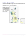
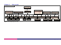
OS VectorMap District User guide Contents Section Preface Chapter 1 Chapter 2 Page no ..................................................................................................................................................4 Contact details ..........................................................................................................................4 Use of the product.....................................................................................................................4 Purpose and disclaimer ............................................................................................................4 Copyright in this guide ..............................................................................................................4 Data copyright and other intellectual property rights ................................................................5 Trademarks ...............................................................................................................................5 Backup provision of the product................................................................................................5 Using this guide.........................................................................................................................5 Introduction to OS VectorMap District beta .........................................................................6 Using the user guide .................................................................................................................6 OS VectorMap District overview ...............................................................................................6 Introduction ..........................................................................................................................6 Shapefile ..............................................................................................................................6 TIFF .....................................................................................................................................6 GML sample tile ...................................................................................................................7 Differences between OS VectorMap District alpha and OS VectorMap District beta...............7 Applications of OS VectorMap District......................................................................................7 What you need to use OS VectorMap District ..........................................................................7 Computer software...............................................................................................................7 Supply format.......................................................................................................................8 Supply media .......................................................................................................................8 Coverage and file sizes .......................................................................................................8 OS VectorMap District explained ..........................................................................................9 Currency....................................................................................................................................9 Completeness ...........................................................................................................................9 Coordinate resolution................................................................................................................9 Generalisation ...........................................................................................................................9 Features represented in the product.........................................................................................9 Buildings ............................................................................................................................10 Roads.................................................................................................................................10 Motorway junctions ............................................................................................................10 Surface water.....................................................................................................................10 Tidal boundary ...................................................................................................................11 Tidal water .........................................................................................................................11 Foreshore...........................................................................................................................11 Land ...................................................................................................................................11 Administrative boundaries .................................................................................................11 Railways.............................................................................................................................12 Railway tunnels..................................................................................................................12 Railway stations .................................................................................................................12 Airport ................................................................................................................................12 Public amenities.................................................................................................................12 Heritage site.......................................................................................................................13 Woodland...........................................................................................................................13 Ornament ...........................................................................................................................13 Electricity transmission line................................................................................................13 Named places ....................................................................................................................13 Spot height.........................................................................................................................14 Simple polygons......................................................................................................................14 Depiction of complex polygons ...............................................................................................14 Edgematching .........................................................................................................................14 Coordinate referencing system ...............................................................................................14 British National Grid (BNG)................................................................................................14 OS VectorMap District user guide contents v1.0 – 03/2011 © Crown copyright Page 2 of 32 Chapter 3 Chapter 4 Annexe A Annexe B Height datum......................................................................................................................14 The National Grid ..................................................................................................................15 OS VectorMap District style definition ...............................................................................16 Road abbreviations...............................................................................................................17 Product and service performance report form ..................................................................18 v1.0 – 03/2011 OS VectorMap District user guide contents v1.0 – 03/2011 © Crown copyright Page 3 of 32 Preface This user guide (hereafter referred to as the guide) is designed to provide an overview of OS VectorMap® District (hereafter referred to as the product) and it gives guidelines and advice on how a customer might derive the maximum benefit from the product. It assumes a general knowledge of geographic information. If you find an error or omission in this guide, or otherwise wish to make a comment or suggestion as to how we can improve the guide, please contact us at the address shown below under contact details or complete the product and service performance report form at annexe B and return it to us. Contact details Our Customer Service Centre will be pleased to deal with your enquiries: Customer Service Centre Adanac Drive Romsey Road SOUTHAMPTON SO16 0AS General enquiries (calls charged at local rate): +44 (0)8456 05 05 05 Dedicated Welsh Language HelpLine: 08456 05 05 04 Textphone (deaf and hard of hearing users only please): +44 (0)23 8005 6146 [email protected] www.ordnancesurvey.co.uk This document has been screened in accordance with the requirements set out in Ordnance Survey's Equality scheme. If you have difficulty reading this information in its current format and would like to find out how to access it in a different format (Braille, large print, computer disk or in another language), please contact us on: +44 (0)8456 05 05 05. Use of the product The product is made available to you and your organisation on the terms of the OS OpenData Licence at www.ordnancesurvey.co.uk/opendata/licence. If there is any inconsistency between the terms of the licence and this guide, the terms of the licence prevail. Purpose and disclaimer This guide is provided for guidance only and does not constitute any warranty, representation, undertaking, commitment or obligation (express or implied) about the product or its suitability for any particular purpose. It is your responsibility to ensure that this product is suitable for your intended purpose. Ordnance Survey does not accept any liability (whether for breach of contract, negligence or otherwise) for any loss or liability you or any third party may suffer in relying on this guide and any guidance, suggestion, advice or explanation provided in it. Ordnance Survey’s liability to you in relation to the product is limited as set out in the OS OpenData Licence. We may change the information in this guide at any time without notice. We do not accept responsibility for the content of any third party websites referenced in or accessed through this guide or through the Ordnance Survey website. Copyright in this guide This guide is © Crown copyright 2011. You may copy or distribute any part of this guide to support the use of OS OpenData, including for your personal use, use in your organisation or business, or for use with, or incorporation in, your product or application. OS VectorMap District user guide preface v1.0 – 03/2011 © Crown copyright Page 4 of 32 Data copyright and other intellectual property rights The Crown (or, where applicable, Ordnance Survey’s suppliers) owns the intellectual property rights in the data contained in this product. You are free to use the product on the terms of the OS OpenData Licence, but must acknowledge the source of the data by including the following attribution statement: Contains Ordnance Survey data © Crown copyright and database right 2011. Trademarks Ordnance Survey, the OS Symbol, OS VectorMap, OS OpenSpace, and OSGB36 are registered trademarks and OS OpenData is a trademark of Ordnance Survey, the national mapping agency of Great Britain. English Heritage is a registered trademark of Historic Buildings And Monuments Commission For England. ESRI is a registered trademark of Environmental Systems Research Institute Inc. OGC is a registered trademark of Open Geospatial Consortium, Inc. Unisys is a registered trademark of Unisys Corporation. W3C is a registered trademark of Massachusetts Institute of Technology. Adobe and Reader are registered trademarks of Adobe Systems Inc. Backup provision of the product You are advised to copy the supplied data to a backup medium. Using this guide The documentation is supplied in portable document format (PDF) only. Free Adobe® Reader® software, which displays the guide, incorporates search and zoom facilities and allows you to navigate within. Hyperlinks are used to navigate between associated parts of the guide and to relevant Internet resources by clicking on the blue hyperlinks and the table of contents. If you are unfamiliar with any words or terms used and require clarification please refer to the glossary at the end of the document. OS VectorMap District user guide preface v1.0 – 03/2011 © Crown copyright Page 5 of 32 Chapter 1 Introduction to OS VectorMap District beta Using the user guide This user guide contains basic information you will need to understand, use and manage OS VectorMap District beta. The OS VectorMap District technical specification contains detailed technical information and data format specification. Annexe A in the user guide provides a list of road abbreviations. Annexe B in the user guide is a product and service performance report form for you to submit any comments on OS VectorMap District. Annexe A in the technical specification is a glossary of terms you will find throughout this user guide. OS VectorMap District overview Introduction OS VectorMap District is a mapping dataset designed for providing contextual mapping output on paper, PCs, hand-held devices or the Internet. The vector format of the product consists of layers to enable you to customise and style output to suit your needs. OS VectorMap District was released as an alpha version in April 2010, as part of the OS OpenData suite of products. The alpha version was put together using technology and processes that were in development at that time; these have been significantly developed to build the beta release made available from March 2011. This beta release offers significantly improved generalisation, resulting in a more attractive map that complements the more detailed street-level OS VectorMap Local product. The product is available in three formats: as a tiled national vector dataset in ESRI® Shapefile format; as a tiled national raster dataset in TIFF (Tagged Image File Format); and a sample area of vector data in Geography Markup Language (GML) for evaluation. The product can be used as mapping in its own right or can be used to provide a flexible geographic context reference for customers’ overlay information. The nominal viewing scale is 1:25 000, with a recommended viewing scale range of 1:15 000 to 1:30 000. Shapefile The vectors demonstrate the versatility of the dataset to be styled in the appropriate way to support a multitude of different geographic purposes. The main characteristics of the vector dataset: Data is represented by points, lines, polygons, and attributes. No persistent feature identifiers. No feature change history. No explicit topology. Tiles are complete in themselves and all polygons that cross tile borders are closed along the tile edges. TIFF The main characteristics of the raster dataset: Can be viewed using typical desktop software. Supplied in a predefined graphical style – see legend. Can be viewed by most image-reading software packages. World files are available, enabling the raster tiles to be georeferenced. OS VectorMap District user guide chapter 1 v1.0 – 03/2011 © Crown copyright Page 6 of 32 GML sample tile Conforms to Open Geospatial Consortium (OGC®) standards. Demonstrates data in GML v3 format. GML schema supplied with the tile. Opportunity to provide feedback on GML structure. Differences between OS VectorMap District alpha and OS VectorMap District beta Sea, land and inter-tidal area features added. Simplified tidal boundaries. Shapefile structure changes. Fewer file sets for the vector format. Improved text positioning. Improved currency. Raster style improved – more suitable styling for use as a backdrop map. More detailed building polygons. GML sample data available in GML v3. Applications of OS VectorMap District The purpose of OS VectorMap District data is to support a wide range of customer applications that utilise geographic information. These may include: Backdrop mapping on your website For your area, you may wish to take advantage of free data on the Government’s data.gov.uk website, for example, air pollution data. The layered structure of OS VectorMap District enables you to display the map to show only the features you want to show – for example, roads, place names and buildings. You may want to style the data as a faded map backdrop to ensure your own or third-party overlaid data are clearly portrayed. Develop an interactive web application OS VectorMap District has been designed for on-screen use, with generalised detail and an appropriate level of content that gives an uncluttered appearance. Subscribers to the OS OpenSpace® application programming interface (API) can build location-based services using the map to guide smartphone users and provide location-specific information. Display your business location Do you want to tell your customers how to get to your business? The district view of OS VectorMap District is ideal for creating a map of a suburban area or part of a city, complete with locality names for context. Your customers can then zoom in to your business at a street level using the OS VectorMap Local product. OS VectorMap District topographic features are representations of real-world objects, including buildings, roads, railways, and rivers. The data also includes non-topographic features such as administrative and electoral boundaries (Shapefile format only), cartographic text and symbols. What you need to use OS VectorMap District Computer software OS VectorMap District vector data is supplied in Shapefile format and will require specialist software for data translation and manipulation. OS VectorMap District user guide chapter 1 v1.0 – 03/2011 © Crown copyright Page 7 of 32 OS VectorMap District raster data is supplied in TIFF and can be viewed using imaging software. Provision of TIFF Worldfiles in TFW and TAB formats means that the raster data can be geo-referenced but this will require a geographical information system (GIS). OS VectorMap District GML sample data will require specialist software for data translation and manipulation. Supply format OS VectorMap District is available as: Vector: ESRI Shapefile with each tile dataset zipped using gzip. Raster: TIFF and compressed using LZW (Lemple-Ziv-Welch) compression. Sample data: GML v3.2.1 and schema zipped as a single file using gzip. Supply media OS VectorMap District can be ordered from the Ordnance Survey OS OpenData™ website. This allows you to order your area of choice and format. Data is available on DVD or as a download from: http://www.ordnancesurvey.co.uk/oswebsite/products/vectormap/district/index.html Coverage and file sizes Shapefile: 55 tiles, each covering 100 km x 100 km comprise the national set. Each tile comprises a set of up to 23 Shapefiles. Each Shapefile holds a single feature type. Features within each Shapefile are cut into a 10 km x 10 km grid. Features that cross the grid line are split. Tile sizes range from 1 Mb to 630 Mb. The data is not encrypted. TIFF: 2860 tiles, each covering 10 km x 10 km comprise the national set. Tiles range from 2 Mb to 4.5 Mb GML sample data: A single tile (SU31) covering an area of 10 km by 10 km OS VectorMap District user guide chapter 1 v1.0 – 03/2011 © Crown copyright Page 8 of 32 Chapter 2 OS VectorMap District explained Currency OS VectorMap District beta version is derived from large-scale data, copyright 2010. Completeness During production many checks are undertaken to ensure that data supplied to customers are both accurate and complete. During digital manipulation in creating the data, all sources of that data are checked for conformance to specification. These quality control checks take the form of: visual checks by operators; data testing against the product specification; and testing carried out on a selection of tiles from a full national set. Coordinate resolution Coordinates have a precision of 1 cm and are stored to two decimal places of a metre. Generalisation The detail within OS VectorMap District has been generalised from Ordnance Survey large-scale data. Map generalisation is the process of reducing the scale and complexity of map detail whilst maintaining the important elements and characteristics of the location. Map generalisation comprises of the following processes: Selection/omission: some features that appear at larger scales are not selected at the smaller scales. For example, many buildings that appear in OS VectorMap Local are omitted from OS VectorMap District. Simplification: simplification can take a number of forms in OS VectorMap District. It can be line simplification, for example, in a vector product, a very winding stream could have the number of data points that represent it reduced. Exaggeration: features that are small but are too important to a particular landscape to be omitted are enlarged. For example, rural buildings are often enlarged to a minimum size rather than being omitted. Aggregation: aggregation is the combining of a number of small features to make a larger one, such as buildings. Symbolisation: features that are shown in detail in OS VectorMap Local may be shown by standard symbolisation in OS VectorMap District. For example, railway stations are depicted as point symbols. Displacement: the movement of the representation of a feature away from its ground position in order to maintain its prominence. There is very little displacement in OS VectorMap District, but in certain circumstances, some features may be moved away from adjacent detail if their representation would otherwise be lost; for example, some buildings are moved away from road edges to ensure they remain prominent. Features represented in the product The following is a description of the features that are available in the product. A full list of feature classes and their associated attributes is given in chapter 4 in the technical specification. Not all features available in the product are included in the raster format. For a full list of features and their styling in the raster format please refer to the legend in chapter 2 of the technical specification. OS VectorMap District user guide chapter 2 v1.0 – 03/2011 © Crown copyright Page 9 of 32 Buildings Buildings are any roofed structure greater than 175 square metres, and are represented as a generalised polygon. Shapefile: Building.shp GML FeatureType: Building Glasshouses greater than 5 000 square metres are represented as polygons. Shapefile: Glasshouse.shp GML FeatureType: Glasshouse Roads Road alignments: these approximate to the road centre lines. Certain types of road have a road name and/or a road number held as attributes of the road alignment. Where a road alignment passes under another road or railway then the alignment is trimmed back either side of the bridge. These features are represented as lines. Road alignments will have one of the following classifications, each of which can be separately identified by the ‘Classification’ attribute – see chapter 4 in the technical specification. ‘Motorway’ ‘Primary Road’ ‘A Road’ ‘B Road’ ‘Minor Road’ ‘Pedestrianised Street’ ‘Local Street’ ‘Private Road, Publicly Accessible’ Shapefile: Road.shp GML FeatureType: Road Road tunnels: these are represented as approximate centrelines of the road that runs through the tunnel. Shapefile: RoadTunnel.shp GML FeatureType: RoadTunnel Differences between vector and raster formats: Road casings appear as a line style in the raster product only. Only a selection of road names and numbers are shown in the raster product, where space permits. Motorway junctions These features are represented as points with the junction number held in the ‘junctionNumber’ attribute. Shapefile: RoadJunction.shp GML FeatureType: RoadJunction Surface water Rivers and streams narrower than 5 m are represented as a single line. Lakes, ponds and rivers or streams wider than 5 m are represented as polygons with their perimeters held as lines. Water features are broken under bridges or other detail. Shapefiles: SurfaceWater_Line.shp, SurfaceWater_Area.shp GML FeatureTypes: SurfaceWater_Line, SurfaceWater_Area OS VectorMap District user guide chapter 2 v1.0 – 03/2011 © Crown copyright Page 10 of 32 Tidal boundary Mean high water/mean high water springs (Scotland) and mean low water/mean low water springs (Scotland) are defined as lines and differentiated by the attribute ’classification’. The tidal limits are shown for their full extents, including from the mouths of rivers to the normal tidal limit (NTL). There is no specific feature defining NTL. For the most part these lines are continuous, but may be broken where they are obscured by other features such as road bridges. Shapefile: TidalBoundary.shp GML FeatureType: TidalBoundary Tidal water The areas of tidal water – defined as the area of water below mean high water/mean high water springs (Scotland), or the NTL of rivers – are represented as polygons. The boundary of tidal water extends to the outer tile limits of the national product set. Shapefile: TidalWater.shp GML FeatureType: TidalWater Foreshore Foreshore lies between mean high water/mean high water springs (Scotland), or the NTL of rivers and mean low water/mean low water springs (Scotland). Foreshore is represented as a polygon, that is, there is no differentiation between sand, mud, shingle and so on. It should be noted that as the tidal water feature extends to mean high water/mean high water springs (Scotland), or the NTL of rivers, the foreshore polygon will overlap the tidal water polygon. This is to assist with styling smaller scale output where the inter-tidal information may not be required. Shapefile: Foreshore.shp GML FeatureType: Foreshore Land All areas above mean high water/mean high water springs (Scotland) or the NTL of rivers are defined as land and represented by a polygon. Shapefile: Land.shp GML FeatureType: Land Administrative boundaries The approximate alignments of the following administrative boundaries are contained within the product. These features are represented as lines. The attribute ‘classification’ defines the type of boundary: ‘National Boundary’ ‘District Or London Borough’ ‘County Or Region Or Island’ ‘Parish Or Community’ Shapefile: AdministrativeBoundary.shp GML FeatureType: AdministrativeBoundary Differences between vector and raster formats: In the raster product only the national boundaries are depicted. OS VectorMap District user guide chapter 2 v1.0 – 03/2011 © Crown copyright Page 11 of 32 Railways All railways are represented as lines and are broken where they pass under bridges, buildings or other obstructing detail. The attribute ‘classification’ defines the type of railway: ‘Multi Track’ ‘Single Track’ ‘Narrow Gauge’ Shapefile: RailwayTrack.shp GML FeatureType: RailwayTrack Railway tunnels All railway tunnel alignments are represented as a single line. Shapefile: RailwayTunnel.shp GML FeatureType: RailwayTunnel Railway stations Railway stations are represented as points. The attribute ‘classification’ defines the type of station: ‘Light Rapid Transit Station’ ‘Railway Station’ ‘Underground Station’ ‘Railway Station And Underground Station‘ ‘Railway Station And Light Rapid Transit Station‘ ‘Light Rapid Transit Station And Underground Station’ The name of the station is held in the attribute ‘name’. The position of the railway station will be close to a railway alignment but will not necessarily be coincident with it. Shapefile: RailwayStation.shp GML FeatureType: RailwayStation Airport A selection of airports are represented as points with a name, held in the ‘name’ attribute. Shapefile: Airport.shp GML FeatureType: Airport The airport name is held in the ‘NAME’ attribute Public amenities A selection of public amenities are represented as points with the attribute ‘classification’ defining the available classes: ‘Education Facility’ ‘Police Station’ ‘Hospital’ ‘Leisure Or Sports Centre’ ‘Place of Worship’ These features do not have their names in the data. In some cases, in particular, schools, there will have been some aggregation carried out with a single feature representing a number of instances that are in close proximity. OS VectorMap District user guide chapter 2 v1.0 – 03/2011 © Crown copyright Page 12 of 32 Shapefile: PublicAmenity.shp GML FeatureType: PublicAmenity Differences between vector and raster formats: Public amenities are not present in the raster product. Heritage site A selection of heritage sites are represented as points and includes World Heritage sites and sites managed by English Heritage®, Cadw and Historic Scotland. Every site has its name held in the attribute ’name’. Shapefile: HeritageSite.shp GML FeatureType: HeritageSite Woodland Areas of trees are represented as polygons. Small areas of woodland are omitted and small clearings in woodland are filled. Shapefile: Ornament.shp GML FeatureType: Ornament Ornament Ornament features are facsimiles of ornament artwork, represented as a polygon, that were previously drawn on paper maps to depict coastal rocks, outcropping rocks, screes and so on. They were drawn from aerial photography and give a good and accurate definition of rock strata. Shapefile: Ornament.shp GML FeatureType: Ornament Electricity transmission line Electricity transmission line alignments are represented as lines. A single line is used to show the alignment of multiple power lines between towers. The electricity transmission towers are not depicted. Shapefile: ElectricityTransmissionLine.shp GML FeatureType: ElectricityTransmissionLine Named places Named places such as settlements, hills, valleys and sea areas are represented by a cartographically-positioned point. Each feature has a number of attributes: Name: the character string of the name in extended ASCII (which includes accented characters with the exception of ŷ and ŵ). HTML Name: is used for those names that contain ŷ or ŵ, where the accents are defined using standard HTML control characters. Font Height: the suggested height of the font in points. Font Type: the suggested font. The values are: 1 = ‘Corbel’ 2 = ‘Corbel Bold’ 3 = ‘Arial’ Orientation: the orientation of the text string in degrees clockwise from horizontal. It is held as a number between 0 and 359, to the nearest degree. OS VectorMap District user guide chapter 2 v1.0 – 03/2011 © Crown copyright Page 13 of 32 Font Colour: this can be used to select different classes of text: Names associated with inland water: Value = 2 Names associated with tidal water: Value = 4 Names associated with woodland: Value = 3 All other names: Value = 1 Shapefile: NamedPlace.shp GML FeatureType: NamedPlace Differences between vector and raster formats: In the raster product, the text will follow complex curves, such as rivers. Spot height Height is represented as a point. The height of the spot height above datum is held in the ‘height’ attribute. A maximum of two spot heights are shown in every 1 km by 1 km grid square representing the highest and lowest values available. Shapefile: SpotHeight.shp GML FeatureType: SpotHeight Simple polygons Simple polygons are depicted in the vector format as outer polygons (with coordinates in a clockwise order). Depiction of complex polygons For complex polygons, that is, polygons containing holes, the holes are depicted as inner polygons (with coordinates in an anticlockwise order) within outer polygons (with coordinates in a clockwise order). Edgematching Tiles are complete in themselves, that is, all polygons that cross tile borders are closed along the tile edges. However, some text features in the vector format are split across tile edges. Where a feature ends by intersecting a 10 km tile edge, it is matched with its corresponding feature on the adjacent tile, so that both features have the same unique coordinates and attribution. There are no features outside the tile edges. Coordinate referencing system The vector product formats provide for the use of a variety of coordinate reference systems. At present, only the British National Grid (BNG) is used in OS VectorMap District. British National Grid (BNG) The BNG spatial reference system uses the OSGB36® geodetic datum and a single Transverse Mercator projection for the whole of Great Britain. Positions on this projection are described using easting and northing coordinates in units of metres. Height datum The BNG is a horizontal spatial reference system only; it does not include a vertical (height) reference system. In OS VectorMap District, heights are given by the ‘height’ attribute in the ‘SpotHeight’ feature. The geometric attributes therefore contain horizontal geometry only. Several orthometric height datums are used by Ordnance Survey to define vertical spatial reference systems. The most common of these is Ordnance Datum Newlyn (ODN), which is used throughout mainland Britain. The height information in OS VectorMap District features does not specify which vertical reference system is used. OS VectorMap District user guide chapter 2 v1.0 – 03/2011 © Crown copyright Page 14 of 32 Chapter 3 The National Grid Ordnance Survey divides Great Britain into squares 100 km by 100 km. Each of these squares has a unique two-letter reference, for example, TG in the diagram below. OS VectorMap District vector format tiles are identified by quoting the National Grid reference of the south-west corner of the 100 km² area they cover, for example TG. To describe an OS VectorMap District raster format tile, which covers 10 km by 10 km, first add a two-digit reference to the 100 km by 100 km square reference, with the easting first followed by the northing, for example, TG23. For additional information on how to use the National Grid, visit the Ordnance Survey website at: http://www.ordnancesurvey.co.uk OS VectorMap District user guide chapter 3 v1.0 – 03/2011 © Crown copyright Page 15 of 32 Chapter 4 OS VectorMap District style definition It is the flexibility to select and style the different feature classes in different ways that makes the vector format of OS VectorMap District such a versatile contextual mapping product. It can be styled in an almost infinite variety of ways to best provide a geographic context to the customer’s overlay information. The raster version is ready-styled and this style is fixed within the limitations of the image viewing software. Below is an example of the raster style. The full graphic legend is at chapter 2 in the technical specification. OS VectorMap District user guide chapter 4 v1.0 – 03/2011 © Crown copyright Page 16 of 32 Annexe A Road abbreviations This annexe gives the approved, shortened and special abbreviations for use with road names (both urban and rural). It contains a list of items that are most likely to occur as the descriptive element within road names. Combinations can be used, for example, SHIRLEY RD S (SHIRLEY ROAD SOUTH) OR N RD ROWNHAMS (NORTH ROAD ROWNHAMS). Three priorities of shortened abbreviations are shown; however, every effort is made to incorporate the full name if possible. Item ALLEY APPROACH ARCADE AVENUE BOULEVARD BROADWAY BROW BUILDINGS BY-PASS CAUSEWAY CENTRE CHASE CIRCLE CIRCUS CLOSE CORNER COURT CRESCENT CROFT CROSS CUT DALE DRIVE DROVE EAST EMBANKMENT ESPLANADE ESTATE FIELD FLY-OVER FOLLY GAP GARDENS GATE GREEN GROVE HEIGHTS HILL HOLLOW JUNCTION LANE LAWN Shortened abbreviations (in priority of use) AL APP ARC AVE BVD BDY BR BLDGS BY-PS CSWY CTR CHA CIRC CIR CL CNR CT CRES CFT CS CU DL DR DRO E EMB ESP EST FLD FLY FO GP GDNS GT GN GR HTS HL HOL JUNC LA LWN Item LEA LOWER MEAD MEADOW MEWS MOUND MOUNT NORTH ORCHARD PARADE PARK PASS PASSAGE PATH PLACE PRECINCT PROMENADE QUAY RIDE RIDGE RISE ROAD ROUNDABOUT ROW SAINT SIDE SPUR SOUTH SQUARE STAIRS STEPS STRAND STREET TERRACE TRACK VALE VIEW VILLAS WAY WEST WHARF YARD Shortened abbreviations (in priority of use) LE LR ME MDW MS MD MT N ORCH PAR PK PS PAS PA PL PREC PROM QY RI RDG RS RD RBT RW ST. SD SP S SQ STRS STPS STR ST TERR TK VA VW VIL WY W WHF YD OS VectorMap District user guide annexe A v1.0 – 03/2011 © Crown copyright Page 17 of 32 Annexe B Product and service performance report form Ordnance Survey welcomes feedback from its customers about OS VectorMap District. If you would like to share your thoughts with us, please print a copy of this form and when completed post or fax it to the address below. Your name: .......................................................................................................................................................... Organisation: ....................................................................................................................................................... Address: ............................................................................................................................................................... .............................................................................................................................................................................. .............................................................................................................................................................................. Postcode: ............................................................................................................................................................. Phone: ................................................................................................................................................................. Fax: ...................................................................................................................................................................... Email: ................................................................................................................................................................... Quotation or order reference: .............................................................................................................................. Please record your comments or feedback in the space below. We will acknowledge receipt of your form within three (3) working days and provide you with a full reply or a status report within 21 working days. If you are posting this form, please send it to: OS VectorMap District Product Manager, Ordnance Survey, Adanac Drive, SOUTHAMPTON, SO16 0AS. If you wish to return it by fax, please dial 023 8005 6159. Any personal information that you supply with this report form will be used by Ordnance Survey only in the improvement of its products and services. It will not be made available to third parties. OS VectorMap District user guide annexe B v1.0 – 03/2011 © Crown copyright Page 18 of 32 OS VectorMap District Technical specification Contents Section Introduction Chapter 1 Chapter 2 Chapter 3 Chapter 4 Page no ................................................................................................................................................20 Purpose of this specification and disclaimer...........................................................................20 Copyright in this specification .................................................................................................20 Data copyright and other intellectual property rights ..............................................................20 OS VectorMap District in GML.............................................................................................21 Use of examples .....................................................................................................................21 Clarification of terms used in this chapter...............................................................................21 Feature attribute.................................................................................................................21 XML attribute......................................................................................................................21 Property .............................................................................................................................21 Schema overview and location ...............................................................................................21 Schema descriptions..........................................................................................................21 Format description ..................................................................................................................22 Documentation...................................................................................................................22 Simple Features Profile – Level 0......................................................................................22 Legend ...................................................................................................................................23 Data model.............................................................................................................................24 Data structure and attributes...............................................................................................25 v1.0 – 03/2011 OS VectorMap District technical specification contents v1.0 – 03/2011 © Crown copyright Page 19 of 32 Introduction Purpose of this specification and disclaimer This is the technical specification (hereafter referred to as the specification) applicable to the OS VectorMap District product (hereafter referred to as the product). We may change the information in this guide at any time without notice. We do not accept responsibility for the content of any third party websites referenced in or accessed through this guide or through the Ordnance Survey website. Copyright in this specification This guide is © Crown copyright 2011. You may copy or distribute any part of this guide to support the use of OS OpenData, including for your personal use, use in your organisation or business, or for use with, or incorporation in, your product or application. Data copyright and other intellectual property rights The Crown (or, where applicable, Ordnance Survey’s suppliers) owns the intellectual property rights in the data contained in this product. You are free to use the product on the terms of the OS OpenData Licence, but must acknowledge the source of the data by including the following attribution statement: Contains Ordnance Survey data © Crown copyright and database right 2011. OS VectorMap District technical specification introduction v1.0 – 03/2011 © Crown copyright Page 20 of 32 Chapter 1 OS VectorMap District in GML This chapter describes the GML format for OS VectorMap District. It is recommended that you read this in conjunction with the Open Geospatial Consortium (OGC) document, Geography Markup Language v3.1.1. The XML specifications that GML is based on are available from the World Wide Web Consortium (W3C®) website: http://www.w3.org. Information about Unicode and UTF-8, the character encoding we have chosen, is available on the Unicode Consortium website: http://www.unicode.org/. Annexe B is a glossary with links to and from the relevant parts of the user guide. Use of examples Any examples in this chapter that mention specific data content are to be taken as examples only. Clarification of terms used in this chapter Feature attribute A property of a feature implemented as an XML element, as defined in ISO 19109. XML attribute Attribute as used in an XML context is referred to as an XML attribute. Property Most feature attributes are encoded as GML properties – property means a GML property. Schema overview and location XML schemas are used to define and validate the format and content of the GML. The GML v3.1.1 specification provides a set of schemas that define the GML feature constructs and geometric types. These are designed to be used as a basis for building application-specific schemas, which define the data content. The Ordnance Survey application schemas, which are referenced by the data, are available in the product release. These schemas make use of XSDs (XML schema definitions) and DTDs (document type definitions) produced by the W3C, which are available from the W3C website at http://www.w3.org/XML/1998/namespace.html. Schema descriptions The W3C-provided XSDs and DTDs are: xml.xsd – to allow the use of the xml:lang attribute for language qualification. XMLSchema.dtd – required by xml.xsd. datatypes.dtd – required by XMLSchema.dtd. The OGC-provided schemas are: feature.xsd – the feature and property constructs. geometry.xsd – the geometric constructs such as polygon and point. xlinks.xsd – a schema based on the W3C XLINK recommendation provided by the OGC to make use of the XLINK constructs. The Ordnance Survey-provided schemas are: OSVectorMapDistrict.xsd – the feature type, complex type and simple type declarations. OS VectorMap District technical specification chapter 1 v1.0 – 03/2011 © Crown copyright Page 21 of 32 Format description Documentation The ‘OSVectorMapDistrict’ schema document defines the following XML namespaces: vmd http://namespaces.ordnancesurvey.co.uk/vmd/beta gml http://www.opengis.net/gml xsi http://www.w3.org/2001/XMLSchema–instance xlink http://www.w3.org/1999/xlink The location of the schema is defined as: http://namespaces.ordnancesurvey.co.uk/vmd/beta OSVectorMapDistrict.xsd Features within each tile are provided in an OSVectorMapFeatureCollection. Simple Features Profile – Level 0 GML is designed to support a wide variety of capabilities, ranging from simple contextual mapping, such as OS VectorMap District, to products that include complex geometric property types or even spatial and temporal topology. The Simple Features Profile of GML 3.1.1 defines a restricted subset of GML, allowing scope for greater interoperability. This product conforms to Simple Features Profile – Level 0. Geometry A geometric property is one that describes a specific geometry. All geometric properties are encoded according to the Simple Features Profile, as referenced above. The XML attribute ‘srsName’ shall be set to ‘osgb:BNG’ (BNG stands for British National Grid), which uses eastings and northings specified in metres. All exterior polygon boundaries have an anticlockwise orientation and all interior polygon boundaries have a clockwise orientation. OS VectorMap District technical specification chapter 1 v1.0 – 03/2011 © Crown copyright Page 22 of 32 Chapter 2 Legend OS VectorMap District technical specification chapter 2 v1.0 – 03/2011 © Crown copyright Page 23 of 32 Chapter 3 Data model class Product - Physical Model - OSVectorMapDistrict Object ESRI Classes::Feature - Shape: esriFieldTypeGeometry NamedPlace VectorMapDistrictFeature Road + + + TidalBoundary + Railw ayTunnel TidalWater Land ID: esriFieldTypeSmallInteger JUNCTIONNUMBER: esriFieldTypeSmallInteger Airport + Woodland - Motorw ayJunction NAME: esriFieldTypeString DFTNUMBER: esriFieldTypeString CLASSIFICATION: esriFieldTypeString RoadTunnel Ornament NAME: esriFieldTypeString Building - ORIENTATION: esriFieldTypeDouble FONTTYPE: esriFieldTypeSmallInteger FONTCOLOUR: esriFieldTypeSmallInteger FONTHEIGHT: esriFieldTypeDouble NAME: esriFieldTypeString HTMLNAME: esriFieldTypeString Administrativ eBoundary + Railw ayTrack - PublicAmenity CLASSIFICATION: esriFieldTypeString - SpotHeight CLASSIFICATION: esriFieldTypeString - SurfaceWater_Line CLASSIFICATION: esriFieldTypeString HEIGHT: esriFieldTypeSmallInteger Railw ayStation + + NAME: esriFieldTypeString CLASSIFICATION: esriFieldTypeString Glasshouse HeritageSite - SurfaceWater_Area Foreshore ElectricityTransmissionLine NAME: esriFieldTypeString Figure 1: ESRI Shapefile physical model OS VectorMap District technical specification chapter 3 v1.0 – 03/2011 © Crown copyright Page 24 of 32 Chapter 4 Data structure and attributes Shapefile Name/GML FeatureType AdministrativeBoundary Geometry Attribute1 LINE Airport Building ElectricityTransmissionLine Foreshore Glasshouse HeritageSite Land NamedPlace POINT POLYGON LINE POLYGON POLYGON POINT POLYGON POINT CLASSIFICA National Parish Or Community District Or London Borough County Or Region Or Island NAME Woodland Ornament PublicAmenity POLYGON POLYGON POINT Attribute2 Attribute3 Attribute4 Attribute5 Attribute6 HTMLNAME ORIENTATIO FONTTYPE 1 2 3 4 FONTCOLOUR FONTHEIGHT 1 2 3 4 NAME NAME CLASSIFICA EducationFacility PlaceOfWorship LeisureOrSportsCentre PoliceStation Hospital OS VectorMap District technical specification chapter 4 v1.0 – 03/2011 © Crown copyright Page 25 of 32 RailwayStation POINT RailwayTrack LINE RailwayTunnel Road LINE LINE MotorwayJunction RoadTunnel SpotHeight SurfaceWater_Area SurfaceWater_Line TidalBoundary POINT LINE POINT POLYGON LINE LINE TidalWater POLYGON CLASSIFICA Light Rapid Transit Station Railway Station Underground Station Railway Station And Underground Station Light Rapid Transit Station And Railway Station Light Rapid Transit Station And Underground Station CLASSIFICA Multi Track Single Track Narrow Gauge NAME NAME DFTNUMBER CLASSIFICA Motorway A Road B Road Minor Road Pedestrianised Street Local Street Primary Road Private Road Publicly Accessible JUNCTIONNU HEIGHT CLASSIFICA High Water Mark Low Water Mark OS VectorMap District technical specification chapter 4 v1.0 – 03/2011 © Crown copyright Page 26 of 32 Attributes Attribute Description Example Data Type Valid values CLASSIFICA (GML: classification) Used to identify different types of feature within a particular class String See the table above FONTCOLOUR (GML: fontColour) Indication of possible style colour 1 Integer FONTHEIGHT (GML: fontHeight) Height of text in point sizes – these values are best used as indicative relative height 7 Integer FONTTYPE (GML: fontType) Indication of possible font style 1 Integer HEIGHT (GML: height) Ground height of heighted point in metres 123 Integer NAME (GML: name) Name of the road, station, airport, heritage site, ground height value, cartographic text and so on Romsey Road; Liverpool John Lennon Airport; Croydon String DFTNUMBER (GML: dftNumber) DFT road number A32 String JUNCTIONNU (GML: junctionNumber) Motorway junction number 6a String ORIENTATIO (GML: orientation) Orientation of the text feature in degrees 24 Integer HTMLNAME (GML: not present) This attribute contains all names, including all accents. Those accented letters that do not have an ASCII value have HTML control characters Abhainn Leòsaid T<f>ŷ</f> Ruttan String 1. 2. 3. 4. Black Blue Green Dark Blue 0-1400 1. Corbel 2. Corbel Bold 3. Arial 0-3500 0-359 OS VectorMap District technical specification chapter 4 v1.0 – 03/2011 © Crown copyright Page 27 of 32 Annexe A Glossary accuracy The closeness of the results of observations, computations or estimates to the true values or the values accepted as being true. Accuracy relates to the exactness of the result, and is the exactness of the operation by which the result is obtained. administrative area A term used by Ordnance Survey to refer to all public administrative areas, specifically local government management and electoral areas. air height This is height derived from aerial photography area A spatial extent defined by circumscribing lines that form a closed perimeter that does not intersect itself. attribute An attribute is a property of an entity, usually used to refer to a non-spatial qualification of a spatially-referenced entity, for example, a descriptive code indicating what an entity represents or how it should be portrayed. attribute value A specific quality or quantity assigned to an attribute. cartography The organisation and communication of geographically-related information in either graphic or digital form. It can include all stages from data acquisition to presentation and use. character A distinctive mark; an inscribed letter; one of a set of writing symbols. character string A one-dimensional array of characters held either in memory or in another storage medium. coding Allocation of a feature code to a feature being created from constituent construction data – points and/or segments; with optional linking to an existing feature of the same feature code. compact disc-read only memory (CD-ROM) A data storage medium. A 12-cm disc similar to an audio CD. Ordnance Survey uses the writable CD, a WORM (write once read many) device. The digital bits are encoded into a vegetable dye and, once written, cannot be erased by overwriting with subsequent data. A laser reads the disc. coordinates Pairs of numbers expressing horizontal distances along original axis. Alternatively, that triplet of numbers measuring horizontal and vertical distances. Row and column numbers of pixels from raw imagery are not considered coordinates for the purpose of the standard. copyright Copyright is a legal property right that enables the creator of an original work to protect it from unauthorised use. Through the Copyright, Designs and Patents Act 1988, Crown copyright continues to subsist in all Ordnance Survey products until the end of the period of 50 years from the end of the year in which they were published, and in the case of data, from the end of the year in which it was extracted from the Ordnance Survey database. Crown copyright is vested in The Controller of Her Majesty’s Stationery Office, who has delegated powers to the Director General, Ordnance Survey for the administration of copyright in publications and data, including the determination of terms and conditions under which permission for their reproduction is given. currency An expression of how up to date data is. OS VectorMap District technical specification annexe A v1.0 – 03/2011 © Crown copyright Page 28 of 32 data A representation of facts, concepts or instructions in a formalised manner suitable for communication, interpretation or processing. data format A specification that defines the order in which data is stored or a description of the way data is held in a file or record. data model An abstraction of the real world that incorporates only those properties thought to be relevant to the application or applications at hand. The data model would normally define specific groups of entities and their attributes and the relationship between these entities. A data model is independent of a computer system and its associated data structures. A map is one example of an analogue data model. dataset An Ordnance Survey term for a named collection of logically-related features arranged in a prescribed manner, for example, all water features. A dataset has more internal structure than a layer and is related to another dataset only by position. distinctive name A text feature consisting of text string(s) that form(s) a proper name. edgematch The process of ensuring that data along the adjacent edges of map sheets, or some other unit of storage, matches in both positional and attributes terms. encryption Using a set of either public or public/private keys to encrypt and decrypt data, it ensures that information is unreadable by anyone other than the intended recipient. feature An item of detail within a map that can be a point or symbol, a line or text. feature class A specific named record that lists the feature codes in use in the current database. feature code (FC) An alphanumeric attribute code used in digital map data to describe each feature in terms of the object surveyed, its representation on the map, or both. feature description A numeric attribute has a textual description that describes the feature in terms either of the object surveyed or its representation on the map (or both). font The style of text character used by a printer or plotter. format The specified arrangement of data, for example, the layout of a printed document, the arrangement of the parts of a computer instruction or the arrangement of data in a record. geographical information system (GIS) A system for capturing, storing, checking, integrating, analysing and displaying data that is spatially referenced to the Earth. This is normally considered to involve a spatially referenced computer database and appropriate applications software. GML Geography Mark-up Language. An XML encoding for the transport and storage of geographic information, including both the geometry and attributes of geographic features. OS VectorMap District technical specification annexe A v1.0 – 03/2011 © Crown copyright Page 29 of 32 Gzip Gzip produces files with a .gz extension. gunzip can decompress files created by gzip, compress or pack. The detection of the input format is automatic. height datum Datum is a known position from which all height information is relatively measured. The heights expressed for points mapped on the National Grid are expressed as a height difference in meters from a known point on the harbour wall in Newlyn, Cornwall. history In the context of geospatial data, the storage of deleted features and superseded versions of features. This does not apply to OS VectorMap District vectors. grid The planimetric frame of reference, for example, the National Grid. kilobyte (KB) 1 024 bytes; a measure of data storage capacity. line A series of connected coordinated points forming a simple feature with homogeneous attribution. line feature The spatial abstraction of an object in one dimension. Lines may intersect with other lines. They are defined as a series of two or more coordinates and may be curved or straight. Curved lines consist of a series of very short straight-line segments. Lines may be concurrent with other lines under certain conditions. As an object abstraction, a line has no width. linear feature Map feature in the form of a line, for example, road centre-lines that may or may not represent a real-world feature. map The representation on a flat surface of all or part of the Earth’s surface, intended to be communicated for a purpose or purposes, transforming relevant geographic data into an end-product that is visual, digital or tactile. map generalisation A reduction in map detail so that the information remains clear and uncluttered when map scale is reduced. May also involve re-sampling to larger spacing and/or a reduction in the number of points in a line. map scale The ratio between the extent of a feature on the map and its extent on the ground; normally expressed as a representative fraction, for example, 1:2500 or 1:50 000. megabyte (MB) 1 048 576 bytes; a measure of data storage capacity. name or text feature The proper name or label of an object (real-world) or feature (object abstraction) consisting of one or more text strings. A name position is defined by a coordinate pair. National Grid A unique referencing system that can be applied to all Ordnance Survey maps of Great Britain at all scales. It is based on 100 km squares covering the whole of GB based on a Transverse Mercator projection. It is used by Ordnance Survey on all post-war mapping to provide an unambiguous spatial reference in Great Britain for any place or entity whatever the map scale. Normal tidal limit (NTL) The point inland to which mean tides (or mean spring tides in Scotland) flow at high water. The point is shown and annotated by text. OS VectorMap District technical specification annexe A v1.0 – 03/2011 © Crown copyright Page 30 of 32 OGC The Open Geospatial Consortium, Inc (OGC) is a non-profit, international, voluntary consensus standards organisation that is leading the development of standards for geospatial and location-based services. orientation Orientation of a point or a text feature is measured in degrees anticlockwise from grid east. orthometric height The distance H along a line of force from a given point P at the physical surface of an object to the geoid. outer bounding polygon These go in an anticlockwise direction. packing Spaces used as fillers to complete a record or field. pecked line A line drawn as a series of dashes. photogrammetric survey Photogrammetric surveyors view 3-D aerial images, by overlaying the images with existing detailed mapping data, they can detect where change has occurred and update the mapping data. point A zero-dimensional spatial abstraction of an object represented as a coordinate pair. point feature A zero-dimensional spatial abstraction of an object with its position defined by a coordinate list. Points are represented by nodes, which may be isolated or part of a link (terminating). Points may also be represented by symbols that may have attributes such as rotation and size. polygon Polygons are a representation of areas. A polygon is defined as a closed line or perimeter completely enclosing a contiguous space and made up of one or more links. At least one node occurs on the perimeter of a polygon where the bounding link completes the enclosure of the area. There may be many nodes connecting the bounding links of a polygon. Links may be shared between polygons. Polygons may wholly contain other polygons, or be contained within other polygons. Each may contain a single isolated node (seed point) that identifies the polygon. polygon boundary The link or links that enclose a polygon, projected into the horizontal plane. positional accuracy The degree to which the coordinates define a point’s true position in the world, directly related to the spheroid/projection on which the coordinate system is based. precision The exactness with which a value is expressed, whether the value be right or wrong. road casings These are parallel lines that define roads alignments in the data. resolution A measure of the ability to detect quantities. High resolution implies a high degree of discrimination but has no implication as to accuracy. For example, in a collection of data in which the coordinates are rounded to the nearest metre, resolution will be 1 m but the accuracy may be ±5 m or worse. rural survey sweep The process by which revision is collected using aerial photography, the resulting 'sweep' is driven by change intelligence. OS VectorMap District technical specification annexe A v1.0 – 03/2011 © Crown copyright Page 31 of 32 Scalable Vector Graphics (SVG) SVG is a language for describing two-dimensional graphics and graphical applications in XML. source scale The scale of the source information from which the map was digitised; that is the scale of survey for a basic-scale map; or the scale of the source map for a derived map. spaghetti data Data that does not carry any explicit topological relationship information. spot height The geographic position of ground surveyed spot heights are represented by ‘Spot height position’. text feature A free-standing text string in the digital data describing a feature, or particular instance of a feature, for example, ‘Factory’ or ‘Acacia Avenue’. text height The height at which a text string is intended to be plotted out at the nominal map scale. This information is included in the feature header of the text feature. tile Broadly synonymous with digital map file, it implies evenly-sized map sheet units. topology The study of the properties of a geometric figure that is not dependent on position, such as connectivity and the relationship between lines, nodes and polygons. update The process of adding to and revising existing digital map data to take account of change. vector A straight line joining two data points. vector data Positional data in the form of coordinates of the ends of line segments, points, text positions and so on. W3C World Wide Web Consortium (W3C) develops interoperable technologies (specifications, guidelines, software and tools) to lead the Web to its full potential. W3C is a forum for information, commerce, communication, and collective understanding. XML Extensible Mark-up Language provides a flexible way to create common information formats and shares both the format and the data on the Internet, Intranets and elsewhere. XML is extensible because, unlike HTML, the mark-up tags are unlimited and self-defining. XML is a simpler and easier to use subset of the Standard Generalised Mark-up Language (SGML), the standard for how to create a document structure. XML schema XML schemas express shared vocabularies; they provide a means for defining the structure, content and semantics of XML documents. OS VectorMap District technical specification annexe A v1.0 – 03/2011 © Crown copyright Page 32 of 32