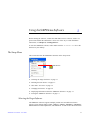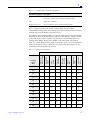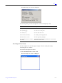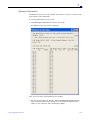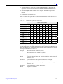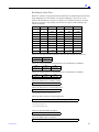
1
SiRFDemo User Guide
SiRF Technology, Inc.
217 Devcon Drive
San Jose, CA 95112 U.S.A.
Phone: +1 (408) 467-0410
Fax: +1 (408) 467-0420
www.SiRF.com
Part Number: 1050-0059
Revision 1.5, June 2007
SiRF, SiRFStar, SiRF plus orbit design are registered in the U.S. Patent and Trademark Office. This document
contains information on a product under development at SiRF. The information is intended to help you evaluate
this product. SiRF reserves the right to change or discontinue work on this product without notice.
SiRFDemo User Guide
Copyright © 1996-2007 SiRF Technology, Inc. All rights reserved.
No part of this work may be reproduced or transmitted in any form or by any means, electronic or
mechanical, including photocopying and recording, or by any information storage or retrieval system
without the prior written permission of SiRF Technology, Inc. unless such copying is expressly
permitted by United States copyright law. Address inquiries to Legal Department, SiRF Technology,
Inc., 217 Devcon Drive, San Jose, California 95112, United States of America.
About This Document
This document contains information about SiRF products. SiRF Technology, Inc. reserves the right to
make changes in its products, specifications and other information at any time without notice. SiRF
assumes no liability or responsibility for any claims or damages arising out of the use of this document,
or from the use of integrated circuits based on this document, including, but not limited to claims or
damages based on infringement of patents, copyrights or other intellectual property rights. SiRF makes
no warranties, either express or implied with respect to the information and specifications contained in
this document. Performance characteristics listed in this data sheet do not constitute a warranty or
guarantee of product performance. All terms and conditions of sale are governed by the SiRF Terms
and Conditions of Sale, a copy of which you may obtain from your authorized SiRF sales
representative.
Getting Help
If you have any problems with your product, contact your SiRF representative or call or send an e-mail
to the SiRF Technology support group:
phone
+1 (408) 467-0410
e-mail
[email protected]
Contents
SiRFDemo User Guide - June 2007
Preface . . . . . . . . . . . . . . . . . . . . . . . . . . . . . . . . . . . . . . . . . . . . . . .
vii
1. Overview . . . . . . . . . . . . . . . . . . . . . . . . . . . . . . . . . . . . . . . . . . . . .
1-1
Supported Products . . . . . . . . . . . . . . . . . . . . . . . . . . . . . . . . . . . . . .
1-1
SiRFDemo Menus. . . . . . . . . . . . . . . . . . . . . . . . . . . . . . . . . . . . . . .
1-2
2. Getting Started . . . . . . . . . . . . . . . . . . . . . . . . . . . . . . . . . . . . . . . .
2-1
Computer Requirements . . . . . . . . . . . . . . . . . . . . . . . . . . . . . . . . . .
2-1
Installing SiRFDemo . . . . . . . . . . . . . . . . . . . . . . . . . . . . . . . . . . . .
2-1
Installing USB Drivers . . . . . . . . . . . . . . . . . . . . . . . . . . . . . . . . . . .
2-2
Windows XP Installation . . . . . . . . . . . . . . . . . . . . . . . . . . . . . .
2-3
Windows 2000 Installation . . . . . . . . . . . . . . . . . . . . . . . . . . . . .
2-3
Windows 98 Installation . . . . . . . . . . . . . . . . . . . . . . . . . . . . . . .
2-4
Connecting a GPS Receiver . . . . . . . . . . . . . . . . . . . . . . . . . . . . . . .
2-4
Quick Start . . . . . . . . . . . . . . . . . . . . . . . . . . . . . . . . . . . . . . . . . . . .
2-5
3. Using the SiRFDemo Software. . . . . . . . . . . . . . . . . . . . . . . . . . . .
3-1
The Setup Menu . . . . . . . . . . . . . . . . . . . . . . . . . . . . . . . . . . . . . . . .
3-1
Selecting the Target Software . . . . . . . . . . . . . . . . . . . . . . . . . . .
3-1
GPS Time / PC Time . . . . . . . . . . . . . . . . . . . . . . . . . . . . . . . . .
3-2
Defining the Data Source . . . . . . . . . . . . . . . . . . . . . . . . . . . . . .
3-3
Aux Serial Port Message Forwarding . . . . . . . . . . . . . . . . . . . . .
3-4
Virtual Serial Port Data Piping . . . . . . . . . . . . . . . . . . . . . . . . . .
3-5
Changing Preferences . . . . . . . . . . . . . . . . . . . . . . . . . . . . . . . . .
3-6
iii
Displaying Information About the SiRFDemo Software . . . . . .
3-7
Exiting the SiRFDemo Software . . . . . . . . . . . . . . . . . . . . . . . .
3-7
The View Menu . . . . . . . . . . . . . . . . . . . . . . . . . . . . . . . . . . . . . . . .
3-7
The 12-Channel Signal Level View Screen . . . . . . . . . . . . . . . .
3-8
The Radar View Screen . . . . . . . . . . . . . . . . . . . . . . . . . . . . . . . 3-11
The Map View Screen . . . . . . . . . . . . . . . . . . . . . . . . . . . . . . . . 3-12
The Navigation Message View Screen . . . . . . . . . . . . . . . . . . . . 3-14
The Response View Screen. . . . . . . . . . . . . . . . . . . . . . . . . . . . . 3-15
The Output View Screen. . . . . . . . . . . . . . . . . . . . . . . . . . . . . . . 3-16
The Error Message View Screen. . . . . . . . . . . . . . . . . . . . . . . . . 3-16
The Debug Data View Screen. . . . . . . . . . . . . . . . . . . . . . . . . . . 3-17
The DGPS View Screen . . . . . . . . . . . . . . . . . . . . . . . . . . . . . . . 3-17
The Geodetic Nav View Screen . . . . . . . . . . . . . . . . . . . . . . . . . 3-18
The PPS Timing View Screen. . . . . . . . . . . . . . . . . . . . . . . . . . . 3-20
Aux Output View Screen . . . . . . . . . . . . . . . . . . . . . . . . . . . . . . 3-21
SiRFDrive View Screen . . . . . . . . . . . . . . . . . . . . . . . . . . . . . . . 3-22
DR NAV SUBSYSTEM DATA . . . . . . . . . . . . . . . . . . . . . . . . . 3-25
SiRFDRive Sensor View Screen. . . . . . . . . . . . . . . . . . . . . . . . . 3-26
SiRFDiRect Graph View Screen. . . . . . . . . . . . . . . . . . . . . . . . . 3-28
Ephemeris Information . . . . . . . . . . . . . . . . . . . . . . . . . . . . . . . . 3-29
The Action Menu . . . . . . . . . . . . . . . . . . . . . . . . . . . . . . . . . . . . . . . 3-31
Opening a Data Source . . . . . . . . . . . . . . . . . . . . . . . . . . . . . . . . 3-32
Opening a Log File . . . . . . . . . . . . . . . . . . . . . . . . . . . . . . . . . . . 3-32
Adding Text to a Log File. . . . . . . . . . . . . . . . . . . . . . . . . . . . . . 3-35
Logging Additional Data . . . . . . . . . . . . . . . . . . . . . . . . . . . . . . 3-35
Pausing the Display . . . . . . . . . . . . . . . . . . . . . . . . . . . . . . . . . . 3-37
Initializing the Data Source . . . . . . . . . . . . . . . . . . . . . . . . . . . . 3-37
Switching to the NMEA Protocol . . . . . . . . . . . . . . . . . . . . . . . . 3-42
Switching to the SiRF Binary Protocol. . . . . . . . . . . . . . . . . . . . 3-43
Synchronizing Protocol and Baud Rate . . . . . . . . . . . . . . . . . . . 3-43
iv
SiRFDemo User Guide—June 2007
Switching to User1 Protocol . . . . . . . . . . . . . . . . . . . . . . . . . . . . 3-44
Setting the Main Serial Port . . . . . . . . . . . . . . . . . . . . . . . . . . . . 3-44
Setting the DGPS Serial Port Parameters . . . . . . . . . . . . . . . . . . 3-45
Setting the UART Configuration . . . . . . . . . . . . . . . . . . . . . . . . 3-45
Uploading an Almanac to a GPS Receiver . . . . . . . . . . . . . . . . . 3-47
Uploading an Ephemeris to a GPS Receiver. . . . . . . . . . . . . . . . 3-47
Opening an Extended Ephemeris File. . . . . . . . . . . . . . . . . . . . . 3-48
Switching Operating Mode . . . . . . . . . . . . . . . . . . . . . . . . . . . . . 3-49
Disabling a Broadcast Ephemeris . . . . . . . . . . . . . . . . . . . . . . . . 3-50
Setting Low Power Parameters . . . . . . . . . . . . . . . . . . . . . . . . . . 3-51
Setting Advanced Power Management Options for SiRFXTrac . 3-54
Setting the Message Rate . . . . . . . . . . . . . . . . . . . . . . . . . . . . . . 3-54
Transmitting a User Defined Serial Message . . . . . . . . . . . . . . . 3-55
The Navigation Menu . . . . . . . . . . . . . . . . . . . . . . . . . . . . . . . . . . . . 3-56
Setting Mode Mask Control . . . . . . . . . . . . . . . . . . . . . . . . . . . . 3-57
Setting the DOP Mask Control . . . . . . . . . . . . . . . . . . . . . . . . . . 3-59
Selecting an Elevation Mask . . . . . . . . . . . . . . . . . . . . . . . . . . . 3-59
Selecting a Power Mask . . . . . . . . . . . . . . . . . . . . . . . . . . . . . . . 3-60
Enabling/Disabling the Static Navigation . . . . . . . . . . . . . . . . . . 3-61
Setting the DGPS Mode . . . . . . . . . . . . . . . . . . . . . . . . . . . . . . . 3-61
Selecting the DGPS Source . . . . . . . . . . . . . . . . . . . . . . . . . . . . 3-62
Setting the SBAS Operating Mode . . . . . . . . . . . . . . . . . . . . . . . 3-63
The Poll Menu . . . . . . . . . . . . . . . . . . . . . . . . . . . . . . . . . . . . . . . . . 3-64
Viewing the Software Version . . . . . . . . . . . . . . . . . . . . . . . . . . 3-65
Polling the Clock Status . . . . . . . . . . . . . . . . . . . . . . . . . . . . . . . 3-65
Polling the Navigation Parameters . . . . . . . . . . . . . . . . . . . . . . . 3-66
Downloading an Almanac File . . . . . . . . . . . . . . . . . . . . . . . . . . 3-67
Downloading an Ephemeris File. . . . . . . . . . . . . . . . . . . . . . . . . 3-68
Polling the Ephemeris State . . . . . . . . . . . . . . . . . . . . . . . . . . . . 3-68
Polling the Extended Ephemeris . . . . . . . . . . . . . . . . . . . . . . . . . 3-69
Contents
v
The SiRFDRive Menu . . . . . . . . . . . . . . . . . . . . . . . . . . . . . . . . . . . 3-69
Setting Navigation Mode Control . . . . . . . . . . . . . . . . . . . . . . . . 3-70
Calibrating the Gyro . . . . . . . . . . . . . . . . . . . . . . . . . . . . . . . . . . 3-70
Setting DR Sensor Parameters . . . . . . . . . . . . . . . . . . . . . . . . . . 3-71
Polling Gyro Factory Calibration . . . . . . . . . . . . . . . . . . . . . . . . 3-72
Polling DR Sensor’s Parameters . . . . . . . . . . . . . . . . . . . . . . . . . 3-72
vi
A. SiRFDemo Real Time View Windows . . . . . . . . . . . . . . . . . . . . . .
A-1
B. File Formats . . . . . . . . . . . . . . . . . . . . . . . . . . . . . . . . . . . . . . . . . .
B-1
Modifying the Sample sirf.pos File. . . . . . . . . . . . . . . . . . . . . . . . . .
B-1
Description of SiRFsig File Formats . . . . . . . . . . . . . . . . . . . . . . . .
B-2
*.avg File . . . . . . . . . . . . . . . . . . . . . . . . . . . . . . . . . . . . . . . . . .
B-2
*.pos File . . . . . . . . . . . . . . . . . . . . . . . . . . . . . . . . . . . . . . . . . .
B-4
*.vel File. . . . . . . . . . . . . . . . . . . . . . . . . . . . . . . . . . . . . . . . . . .
B-4
*.### File . . . . . . . . . . . . . . . . . . . . . . . . . . . . . . . . . . . . . . . . . .
B-4
*.svs File. . . . . . . . . . . . . . . . . . . . . . . . . . . . . . . . . . . . . . . . . . .
B-4
C. Acronyms and Abbreviations Glossary. . . . . . . . . . . . . . . . . . . . .
C-1
SiRFDemo User Guide—June 2007
Preface
The SiRFDemo User Guide contains detailed information about how to use the
software tool called SiRFDemo.
This User Guide is based on SiRFDemo release version 3.87, but may be relevant to
later versions.
Who Should Use This Guide
This manual was written assuming the user has basic computer skills and is familiar
with the Windows operating environment.
How This Guide Is Organized
Chapter 1, “Overview” gives a high-level overview of the SiRFDemo software
product including what it does, supported products, and available menus.
Chapter 2, “Getting Started” explains how to install the software and hardware, how
to start the SiRFdemo software, basic operation, and how to ensure that the software
and the GPS receiver are operating correctly.
Chapter 3, “Using the SiRFDemo Software” describes SiRFdemo menu functions.
Appendix A, “SiRFDemo Real Time View Windows” lists supplimental information
about message content in the SiRF real time view windows.
Appendix B, “File Formats” describes the format of files that are either used by the
SiRFDemo software or are created by the SiRFsig software.
Appendix C, “Acronyms and Abbreviations Glossary” describes all acronyms,
abbreviations, and selected terms used in SiRF documentation..
SiRFDemo User Guide - June 2007
vii
Troubleshooting/Contacting SiRF Technical Support
Address:
SiRF Technology Inc.
217 Devcon Drive
San Jose, CA 95112 U.S.A.
SiRF Technical Support:
Phone: +1 (408) 467-0410 (9 am to 5 pm Pacific Standard Time)
Email:
[email protected]
General enquiries:
Phone: +1 (408) 467-0410 (9 am to 5 pm Pacific Standard Time)
Email:
[email protected]
Helpful Information When Contacting SiRF Technical Support
Receiver Serial Number: __________________
Receiver Software Version: ________________
SiRFDemo Version: ____________________
viii
SiRFDemo User Guide—June 2007
Overview
1
The SiRFDemo software is a tool that provides real-time monitoring of an attached GPS
receiver’s operation such as satellites being tracked, observed signal strength, and current
position. It also provides the ability to configure the receiver for specific operating
modes, as well as a data logging ability for later investigation.
See Chapter 3, “Using the SiRFDemo Software” for detailed information on the use
and operation of the SiRFDemo software.
Supported Products
The SiRFDemo software supports multiple product lines and different software releases.
Available features of SiRFDemo may be different, available, or not available depending
on the GPS product being used. Supported GPS products include:
•
•
•
•
•
•
•
•
GSW2
SiRFXTrac
SiRFNav
SiRFDRive
GSW3
GSWLT3
SiRFDiRect
SiRFInstantFix Extended Ephemeris
By default, SiRFDemo automatically detects the SiRF GPS product being used and is
configured accordingly.
Throughout this manual, where appropriate, the product that a particular SiRFDemo
feature supports is indicated.
SiRFDemo User Guide - June 2007
1-1
1
SiRFDemo Menus
The SiRFDemo software typically has six menus—seven when SiRFDRive, SiRFDiRect
& SiRFNav are selected as target software. This seventh menu is also available when
SiRFDRive is chosen as the target software. All menus are described in Table 1-1.
Table 1-1
SiRFDemo Menus
Menu
Description
Setup
The Setup menu lets you configure the data source used by SiRFDemo and the
operating preferences via these menu items:
Target Software
Time
Data Source
Preferences
Software Info
See “The Setup Menu” on page 3-1 for detailed information about the Setup menu.
View
The View menu lets you display different view windows. The available view
windows include:
Signal
Radar
Map
Navigation
Response
Output
Error
Debug
DGPS
Geodetic Nav
PPS Timing
Auxiliary Output
SiRFDRive (available only when the selected software target is SiRFDRive, SiRFDiRect, or
SiRFDRive & SiRFNav)
SiRFDRive Sensor
(available only when the selected software target is SiRFDRive, SiRFDiRect or
SiRFDRive & SiRFNav)
SiRFDiREct Graph (available only when the selected software target is SiRFDiRect)
Ephemeris Information (available only when the selected software target is 2.3)
See “The View Menu” on page 3-7 for detailed information about the View menu.
1-2
Action
The Action menu provides access to most of the SiRFDemo functionality such as
configuration of the connected GPS receiver, data logging for later analysis, the
extended ephemeris features. See “The Action Menu” on page 3-31 for detailed
information about the Action menu.
Navigation
The Navigation menu lets you configure items that effect how a position solution
is acquired or the type of position needed. From the Navigation menu, you can set
various operating masks, the DGPS mode, and the DGPS source. See “The
Navigation Menu” on page 3-56 for detailed information about the Navigation
menu.
SiRFDemo User Guide—June 2007
1
Table 1-1
SiRFDemo Menus (Continued)
Menu
Description
Poll
The Poll menu is used to obtain information about the attached GPS receiver such
as software version, navigation parameters, and clock status. You can also use the
Poll menu to obtain the latest ephemeris, almanac, and extended ephemeris. See
“The Poll Menu” on page 3-64 for detailed information about the Poll menu.
Window
The commands on the Window menu commands control the appearance of the
information displayed.
SiRFDRive
The SiRFDRive menu is used to provide control of a SiRFDRive or SiRFDiRect
enabled product. This menu is only available when SiRFDRive, SiRFDiRect, or
SiRFDRive and SiRFNav are selected as the target software. See “The SiRFDRive
Menu” on page 3-69 for detailed information about the Poll menu.
Note – The values that appear in the dialog boxes are default values and not what is
currently set in the GPS receiver. See “Polling the Navigation Parameters” on page 366 to determine the current settings of all navigation parameters.
Overview
1-3
Getting Started
2
This chapter describes the minimum computer requirements, installing SiRFDemo, and
how to quickly get started using the software. See Chapter 3, “Using the SiRFDemo
Software” for detailed information on SiRFdemo operation.
Computer Requirements
The following is the minimum computer configuration that is required to achieve
reliable operation.
•
•
•
486 processor (or better)
•
•
Windows 98, NT, 2000, or XP operating system
16MB RAM minimum memory
100MB minimum available disk space for PC software tools installation and data
logging
One available RS232 serial port
Installing SiRFDemo
To install SiRFDemo from the provided CD:
1. Insert the CD into your CD-ROM drive.
A CD browser automatically launches and displays on the screen.
2. Select Install Software Tools from the main menu of the browser interface.
3. Select SiRFDemo.
An install shield guides you through the rest of the installation.
SiRFDemo User Guide - June 2007
2-1
2
After installation is complete, a shortcut is placed on your desktop and within the
Start / Programs menu.
To install the software tools without using the CD browser:
1. Insert the CD into your CD-ROM drive.
2. Using Windows Explorer, navigate to the folder of the software tool you want to
install.
3. Double click on the file SETUP.EXE.
An install shield guides you through the rest of the installation.
Note – During the install process, USB driver files are copied into the SiRFDemo
directory. These files are required when USB communication is used. Additional
installation of the drivers are required after installing SiRFDemo.
Installing USB Drivers
SiRFDemo supports USB communication. Before USB can be used however, it is
necessary to install the required UBS drivers. These drivers have been copied to the
SiRFDemo directory during the installation process of SiRFDemo. The install process
for the USB drivers is different for different operating systems.
Note – When USB is being used, the USB port is listed as an additional serial port in
the Data Source Setup dialog.
2-2
SiRFDemo User Guide—June 2007
2
Windows XP Installation
To install the required USB drivers on Windows 2000:
1. Connect the USB enabled SiRF GPS receiver to your PC.
Windows opens a “Found New Hardware Wizard” window.
2. Select “Install from a list or specific location (Advanced)” and press Next.
3. Select “Include this location in the search”.
4. Press Browse to locate the directory where the drivers are located and press OK.
The drivers were copied to the SiRFDemo directory during the SiRFDemo
installation. By default, the directory is “C:\Program
Files\SiRF\SiRFDemo\usbDrivers”
5. Press Finish to complete the installation of the “CP2101 USB Composite Device”.
Windows now opens a second “Found New Hardware Wizard” window.
6. Repeat steps 2 through to 4.
7. Press Finish to complete the installation of the “CP2101 USB to UART Bridge
Controller”.
Windows 2000 Installation
To install the required USB drivers on Windows 2000:
1. Connect the USB enabled SiRF GPS receiver to your PC.
Windows opens a “Found New Hardware Wizard” window.
2. Press Next to continue.
3. Select “Search for the best driver for your device (Recommended)” and press Next.
4. Select “Specify a location” and press Next.
5. Press Browse and locate the file “slabbus.inf”.
The drivers were copied to the SiRFDemo directory during the SiRFDemo
installation. By default, the directory is “C:\Program
Files\SiRF\SiRFDemo\usbDrivers”
6. Press Finish to complete the installation of the “CP2101 USB Composite Device”.
Windows now opens a second “Found New Hardware Wizard” window.
7. Press Next to continue and follow steps 2 through to 4.
Getting Started
2-3
2
8. Press Browse and locate the file “slabw2k.inf”.
9. The drivers were copied to the SiRFDemo directory during the SiRFDemo
installation. By default, the directory is “C:\Program
Files\SiRF\SiRFDemo\usbDrivers”
10. Press Finish to complete the installation of the “CP2101 USB to UART Bridge
Controller”.
Windows 98 Installation
To install the required USB drivers on Windows 98:
1. Connect the USB enabled SiRF GPS receiver to your PC.
Windows opens a “Found New Hardware Wizard” window.
2. Press Next to continue.
3. Select “Search for the best driver for your device (Recommended)” and press Next.
4. Select “Specify a location”.
5. Press Browse to locate the directory where the drivers are located and press Next.
The drivers were copied to the SiRFDemo directory during the SiRFDemo
installation. By default, the directory is “C:\Program
Files\SiRF\SiRFDemo\usbDrivers”
6. Press Finish to complete the installation of the “CP2101 USB Composite Device”.
Windows now opens a second “Found New Hardware Wizard” window.
7. Press Next to continue and follow steps 2 through to 5.
8. Press Finish to complete the installation of the “CP2101 USB to UART Bridge
Controller”.
Connecting a GPS Receiver
To connect a SiRF GPS receiver ready for operation with SiRFDemo:
1. Connect the GPS antenna to the antenna GPS input on the GPS receiver and place
the antenna in a location where it has a clear view of the sky.
2. Connect one end of a serial cable to the appropriate communications port on your
computer.
3. Connect other end of the serial cable to Com A on the GPS receiver.
4. Connect a power supply to the GPS receiver and power it on.
2-4
SiRFDemo User Guide—June 2007
2
Quick Start
The following provides instructions on getting SiRFDemo started and operating
correctly with a SiRF-based GPS product.
To get started quickly:
1. Connect the GPS receiver to your PC using the provided serial cable and power on
the receiver.
For more information about installing the GPS receiver, please see the associated
Users Guide.
2. Double-click on the SiRFDemo shortcut on your desktop that was created during
the install process.
The Data Source Setup screen is displayed.
3. Select the PC serial port that is being used from the Serial Port pull down list and
the baud rate the receiver is operating at from the Baud Rate pull down list.
Note – SiRFDemo only displays a list of available serial ports. When USB is being
used, the USB port is listed as an additional serial port.
4. Click OK.
By default, the Signal Level, Tracking, and Map views are displayed.
5. Click the Connect/Disconnect button.
Getting Started
2-5
2
When your GPS receiver is properly connected and tracking GPS satellites, the
Signal Level, Tracking, and Map views display information about the current
operation of the receiver.
For detailed information about each of the views, please see “The View Menu” on
page 3-7.
When no information is displayed on any of the screens, ensure that:
•
•
•
The receiver is switched on and has a clear view of the sky.
The serial cable is correctly connected.
The correct serial port and baud rate are selected in the Data Source Setup dialog
under the Setup menu.
Finally, select Synchronize Protocol & Baud Rate from the Action menu.
2-6
SiRFDemo User Guide—June 2007
Using the SiRFDemo Software
3
Before running the software, connect the SiRF GPS receiver to the PC, ensure it is
powered on and that the antenna has a clear view of the sky. For full installation
instructions, see Chapter 2, “Getting Started.”
To start the SiRFDemo software, either double click the sirfdemo.exe file or the
shortcut on your desktop.
The Setup Menu
This section describes the SiRFDemo functions on the Setup menu:
Data Source
•
•
•
•
•
•
“Selecting the Target Software” on page 3-1
“Defining the Data Source” on page 3-3
“GPS Time / PC Time” on page 3-2
“Changing Preferences” on page 3-6
“Displaying Information About the SiRFDemo Software” on page 3-7
“Exiting the SiRFDemo Software” on page 3-7
Selecting the Target Software
The SiRFDemo software supports multiple product lines and different software
releases. These include GSW2, GSW3, GSWLT3, SiRFNav, SiRFDRive, SiRFDiRect,
SiRFInstantFix Extended Ephemeris, and SiRFXTrac. A built-in auto-detection feature
SiRFDemo User Guide - June 2007
3-1
3
allows SiRFDemo to identify the hardware/software platform it is connected to and
configure the dropdown menus correctly. This provides access to features that are
common to both platforms, such as protocol, and individual access and definition to
features that are either unique, such as Static Navigation, or redefined, such
as TricklePower, for each platform.
Once connected, SiRFDemo attempts to identify the connected product and software
release. When the hardware detection function fails, you are prompted to select the
target software manually. The auto-detection function can be disabled by unchecking
the Auto-detection checkbox.
To select the target software type:
1. Select Target S/W from the Setup menu.
The Select Target Software dialog is displayed.
2. Select the appropriate target software.
3. Uncheck the Auto-detection checkbox to disable the auto-detection function or when
the auto-detection fails.
4. Click OK to accept the selection.
GPS Time / PC Time
The SiRFDemo software is capable of matching GPS clock time to PC time. When the
difference between GPS time and PC is greater than two seconds, PC clock is set to
match GPS time.
To select GPS Time / PC Time:
1. Select GPS Time / PC Time from the Setup menu.
3-2
SiRFDemo User Guide—June 2007
3
The Setup menu is displayed.
When a checkmark appears next to GPS Time, the clocks are matched.
Defining the Data Source
The SiRFDemo software is capable of receiving data from different sources. You can
configure SiRFDemo to receive data directly from a connected GPS receiver, generate
its own random data, or load data from a previously logged file.
To configure the source of the data used by the SiRFDemo software:
1. Click the Data Source button or select Data Source from the Setup menu.
The Data Source Setup screen is displayed.
2. Select either the Serial Port, File, or Random as the required data source. The
following table provides a description of each available option:
Option
Description
Serial Port
SiRFDemo uses data directly from a connected GPS receiver. The connected
communication port and the used Baud rate must be selected.
File
SiRFDemo uses data that is contained within an existing data file. The file may
contain data in either SiRF Binary or NMEA formats.
Random
SiRFDemo uses randomly generated data. Use this option to verify that the
SiRFDemo software is running without any receiver connected.
Aux Data
Source
Provided for SiRFDRive use only, SiRFDemo can be configured to receive
external data from another source other than the GPS receiver.
Note – SiRFDemo only displays a list of available serial ports. When USB is being
used, the USB port is listed as an additional serial port.
Using the SiRFDemo Software
3-3
3
3. Click OK to accept selected settings.
Aux Serial Port Message Forwarding
When both the Main and Aux serial ports are open, some SiRF Binary messages
received on one port are forwarded to the other port.
To use the auxiliary data source:
1. Select Data Source from the Setup menu.
The Data Source Setup screen is disrplayed.
2. Check the Use Aux Data Source checkbox.
•
Any SiRF Binary message received on the Aux port is sent to the Main port and
logged in the .gps log file as CLM->GPS.
•
When SiRF Binary msg 0x38 or 0xE8 is received on the Main serial port, it is
forwarded to the Aux port and logged in the .gps log file as GPS->CLM.
TCP instead of Serial Port Option
The main data source can be configured as a TCP/IP connection instead of a serial
port. This is useful when the test setup is SD<->CLM<->Rx, and the connection
between the CLM and Rx is a physical serial port, while the SD to CLM connection is
TCP.
To do this, select TCP:7555 from the Aux Data Source Port dropdown menu.
3-4
SiRFDemo User Guide—June 2007
3
The number 7555 is the port that is used on your local host machine (IP=127.0.0.1), in
this case 7555 is the default port for the CLM test app.
Note that the log file contains two new messages when logging TCP data:
•
•
Any data sent is logged as TCPx: 0xA0A2… instead of Tx: 0xA0A2…
When TCP data is received a ‘TCP data len=’ message is logged showing the
number of bytes received over TCP.
Virtual Serial Port Data Piping
The user has the option of creating a virtual serial port for piping serial data to an
additional application. The use of this functionality is optional. If an external virtual
serial port is not desired, do not check the Create Virtual Serial Port option on the Setup
menu.
The virtual serial port will be created and opened when the primary serial connection is
established, and it will be closed and removed when the primary serial connection is
closed. A separate application will be able to open the virtual serial port to receive the
piped data output.
Note – At this time, only NMEA data can be output through the virtual serial port. If
operating in SiRF Binary, serial data input will be converted to NMEA before being
piped out the virtual serial port.
To use the auxiliary data source:
1. Select Data Source from the Setup menu.
The Data Source Setup screen is displayed.
2. Check the Create Virtual Serial Port checkbox.
3. From the Virtual Port Data Piping Port pulldown menu select the virtual port through
which serial data will be output.
4. Choose the desired output Protocol from the pulldown menu.
Note – Only NMEA data piping is available at this time.
5. Click OK to accept selected settings.
Using the SiRFDemo Software
3-5
3
Note – If Virtual Serial Port Drivers have not yet been installed, you will be prompted
to install at this time. Follow onscreen instructions.
6. Open the external application and choose the created virtual serial port as the data
input port.
Changing Preferences
You can change the appearance of some of the view windows to suit your personal
preferences. View preferences include the Signal Level view, the Tracking view, and
the Map view.
To change the appearance of the view windows:
1. Select Preferences from the Setup menu.
The Preferences screen is displayed.
2. Select the type of signal graph that you want to view on the 12-Channel Signal
Level View screen.
Option
Description
Bar
Displays the data with vertical bars to represent the observed signal strength
of each satellite.
Line
Displays the data in a continuous line graph form.
3. Select the direction of the tracking orientation that you want to use in the Tracking
View screen.
Option
Description
North Up
True north points to the top of the circle.
Heading Up
This is typically used when the board is moved by simulation. Again, it is not
recommended to use the board in a vehicle. Current heading points to the top
of the circle.
4. To change the scale of the Map view, enter the number of meters you want each
pixel to represent in the Meters Per Pixel field.
5. Click Save to save the changes or Cancel to exit without saving changes.
3-6
SiRFDemo User Guide—June 2007
3
Displaying Information About the SiRFDemo Software
1. Select About SiRFDemo from the Setup menu to display SiRFDemo software
information:
Exiting the SiRFDemo Software
1. Select Exit from the Setup dropdown menu.
This closes SiRFDemo software.
The View Menu
This section describes the SiRFDemo functions on the View menu:
Signal Level
Tracking
Map
•
•
•
•
•
•
•
•
Using the SiRFDemo Software
“The 12-Channel Signal Level View Screen” on page 3-8
“The Radar View Screen” on page 3-11
“The Map View Screen” on page 3-12
“The Navigation Message View Screen” on page 3-14
“The Response View Screen” on page 3-15
“The Output View Screen” on page 3-16
“The Error Message View Screen” on page 3-16
“The Debug Data View Screen” on page 3-17
3-7
3
•
•
•
•
•
•
•
•
“The DGPS View Screen” on page 3-17
“The Geodetic Nav View Screen” on page 3-18
“The PPS Timing View Screen” on page 3-20
“Aux Output View Screen” on page 3-21
“SiRFDrive View Screen” on page 3-22
“SiRFDRive Sensor View Screen” on page 3-26
“SiRFDiRect Graph View Screen” on page 3-28
“Ephemeris Information” on page 3-29
The 12-Channel Signal Level View Screen
The 12-Channel Signal Level View screen is a combined graphical and text display of
satellite tracking. Information shown by the Signal Level view includes satellite
number, status, azimuth, elevation, C/No, and last five seconds of measured signal
strength.
To display the 12-Channel Signal Level view screen:
1. Click the Signal Level View button or select Signal Level from the View menu.
Note – The Preferences screen allows you to modify the way information is displayed.
Double-click the 12-Channel Signal Level View screen to display the Preferences
screen.
Table 3-1 12-Channel Signal Level View Information
3-8
Information Displayed
Description
Satellite Number (SV)
The GPS satellite PRN number.
Status (St)
The status of each satellite tracked (see Table 3-2, “Tracking Status
Definitions,” on page 3-9 for more information).
Azimuth (Az)
Satellite azimuth (in degrees).
SiRFDemo User Guide—June 2007
3
Table 3-1 12-Channel Signal Level View Information
Information Displayed
Description
Elevation (El)
Satellite elevation (in degrees) with the horizon being zero degrees
in elevation, and directly over-head being ninety degrees.
C/No
Signal level (in dB-Hz).
Signal Level (-5 sec)
Five-second history of the measured signal strength.
Table 3-2 represents each of the possible tracking status messages and the
corresponding tracking status. Each tracking status state corresponds with an achieved
tracking stage for each channel of the GPS receiver.
For example, when a tracking status of 33 (Hex) is displayed, this means that satellite
acquisition is achieved, the delta-phase is valid, the carrier pull-in is complete, and the
code is locked onto. From a cold start you typically see the following sequence of
tracking status changes; 00Æ33Æ37Æ3FÆBF. It only takes about one second to
achieve a 37 status, approximately another 12 seconds to get to a 3F status, and finally
another 20 seconds to achieve a BF status. The sequence and time frames may vary
considerably between channels and sessions.
Table 3-2 Tracking Status Definitions
Acquisition
Success
Delta-phase
Valid
Bit-sync
Done
Sub-frame
Sync Done
Carrier
Pull-in Done
Code
Locked
Acquisition
Failed
Tracking
Status
(Hex)
Ephemeris
Data Available
Achieved Tracking Stage
00
9
01
9
03
21
9
23
9
25
9
9
27
9
9
2D
9
33
9
9
37
9
9
3F
9
9
8D
Using the SiRFDemo Software
9
9
9
9
9
9
9
9
9
9
9
9
9
9
9
9
9
9
9
9
9
9
9
3-9
3
Table 3-2 Tracking Status Definitions (continued)
Acquisition
Success
Delta-phase
Valid
Bit-sync
Done
AD
9
9
9
9
AF
9
9
9
9
9
9
BF
9
9
9
9
9
9
Tracking
Status
(Hex)
Code
Locked
Sub-frame
Sync Done
Carrier
Pull-in Done
Acquisition
Failed
Ephemeris
Data Available
Achieved Tracking Stage
9
9
9
40
CC
9
9
9
9
CD
9
9
9
9
9
See “Navigation Library SV State Data - Message ID 30” in the SiRF Binary Reference
Manual for information about SiRF extended ephemeris tracking status messages.
The information displayed in the Signal Level view is also assisted by color coding. As
the tracking status of each satellite changes, the associated text and signal levels are
colored to represent the current status (see Table 3-3).
Table 3-3 12-Channel Signal Level View Color Coding
Color
Description
Red
The satellite location is known from almanac information; however, the satellite is
not currently being tracked.
Blue
The satellite is being tracked; however, it is not being used in the current position
solution.
Green
The satellite is being tracked and is being used in the current position solution.
Aqua
For SBAS satellites only. The satellite is being tracked and corrections are being
used in the current position.
Magenta The satellite is being tracked; however, a SiRFInstantFix extended ephemeris is
being used for the position solution.
3-10
SiRFDemo User Guide—June 2007
3
The Radar View Screen
The Radar View screen graphically displays the location of each of the tracked, used,
and available satellites in the form of a polar plot.
To display the Radar View screen:
1. click the Radar View button or select Radar from the View menu.
In addition to the satellite locations, the current tracking status is represented by color
(see Table 3-4).
Table 3-4 Tracking View Color Coding
Color
Description
Red
The satellite location is know from almanac information; however, the satellite is
not currently being tracked.
Blue
The satellite is being tracked; however, it is not being used in the current position
solution.
Green
The satellite is being tracked and is being used in the current position solution.
Aqua
For SBAS satellites only. The satellite is being tracked and corrections are being
used in the current position.
Magenta
.The satellite is being tracked; however, a SiRFInstantFix extended ephemeris is
being used for the position solution.
Current speed and heading (in a dynamic environment such as a moving vehicle) is
represented by an arrow. The direction of the arrow represents heading while the
length of the arrow indicates speed over ground.
Using the SiRFDemo Software
3-11
3
Configuring the Radar View Screen
The Radar view screen orientation and velocity representation can be configured.
To configure the Radar view screen:
1. Double click the Radar View screen to display the Tracking View Configuration
screen.
2. Select the direction of the tracking orientation that you want to use.
Option
Description
North Up
True north points to the top of the circle.
Heading Up
This option can be used when driving. Current heading points to the top of
the circle.
3. Enter the Outer circle velocity (in m/sec).
Note – The setting of the outer circle velocity means that when the arrow length
reaches the outer circle of the plot, then the outer circle velocity has been reached.
4. Click OK to save the changes or Cancel to exit without saving changes.
The Map View Screen
The Map view screen displays a combination of graphical and text-based information.
Positions generated by the GPS receiver are plotted on the Map view screen while
other information such as GPS time, GPS week, position mode, current position,
heading, velocity, DOP, type of position fix, and satellites tracked are displayed as text.
To display the Map view screen:
3-12
SiRFDemo User Guide—June 2007
3
1. Click the Map View button or select Map from the View menu.
The Map View screen is displayed.
The current position is represented on the plot by a red dot, while past positions are
displayed in blue.
2. Click Clear at any time to clear any plotted positions on the plot.
3. Click Current as Origin to make the origin of the plot the same as the most recent
plotted position.
Note – When using the map view, you may want to change the way it is displayed. To
edit display preferences, see “Changing the Map View Preferences” on page 3-13.
Changing the Map View Preferences
The ability to change the scale of the Map view and the origin of the map is provided
by the Map view preferences.
To change the Map view preferences:
1. Double click the Map View screen to display the Preferences window.
Using the SiRFDemo Software
3-13
3
2. Enter the number of meters you want each pixel to represent in the meters/pixel
field. This value controls the map scale.
3. Enter the latitude and longitude (in WGS-84) of the required center of the Map
View display in the Lat and Lon fields.
4. To display up to three rings on the MapView display, enter the radius (in meters) of
each of the rings in the Ring Radii group.
When a value of zero is entered, the ring is not be displayed.
5. Click Save to save the changes or Cancel to exit.
The Navigation Message View Screen
The Navigation Message view screen is used to display position solution information
such as GPS time, GPS week, position mode, current position, heading, velocity, DOP,
type of position fix, and satellites tracked.
To view the Navigation Message View screen:
1. Select Navigation Message from the View menu.
The Navigation Message View screen is displayed.
Table 3-5 Navigation Message View Information
3-14
Information
Displayed
Description
X, Y, Z positions
Coordinates of user’s position in ECEF (meters)
Velocity
User’s velocity in ECEF (m/sec)
Latitude
User’s latitude (decimal of degrees)
Longitude
User’s longitude (decimal of degrees)
Altitude
User’s altitude (meters)
Heading
.GPS product’s direction.
Mode 1
Navigation solution type. This changes from a No Nav status, through the
different fix modes such as 2D, 3DLSQ etc. The Mode field should be used
for any TTFF measurements
GPS Week
GPS week number
SiRFDemo User Guide—June 2007
3
Table 3-5 Navigation Message View Information (continued)
Information
Displayed
Description
DOP
Dilution of Precision
Fix 2
Validated/unvalidated. From an unvalidated state, a five SV position solution
must be achieved to become a validated position. If the board continues to
navigate in a degraded mode (3D, 2D, 1SV, or DR), then the validated status
remains. When navigation is lost completely, an unvalidated status results.
Time
Current GPS time (seconds)
SVs Used in Fix
SV PRN used in solution
Time To First Fix The TTFF value is cleared any time a no-nav position is reported (msg 2), so
the TTFF field is automatically cleared when a reset command is sent
1. The Mode field is mapped to SiRF Binary Protocol MID2, mode 1 (see the SiRF Binary Reference Manual). The mode field
should be used as the TTFF indicator and not the Fix field with any non-zero value of mode 1 indicating a usable navigation solution.
2. The Fix field is mapped to SiRF Binary Protocol MID2, mode 2 (see the SiRF Binary Reference Manual).
Note – ECEF XYZ is converted geodetic latitude, longitude, and altitude based on the
WGS84 ellipsoid parameters.
The Response View Screen
The Response View screen is used to display any response to a poll request. You can
poll the GPS receiver for the software version (see ““Polling the Extended Ephemeris”
on page 3-69” on page 3-64), clock status (see “Polling the Clock Status” on page 365), navigation parameters (see “Polling the Navigation Parameters” on page 3-66),
ephemeris state (see “Polling the Ephemeris State” on page 3-68), and gyro calibration
verification (see “Polling Gyro Factory Calibration” on page 3-72).
To display the Response View screen:
1. Select Messages Response from the View menu
The Response View screen is displayed.
Using the SiRFDemo Software
3-15
3
The Output View Screen
The Output View screen is used to display the SiRF Binary message IDs that are
currently being output by the attached GPS receiver.
To display the Output View screen:
1. Select Messages Output from the View menu.
The Receiver Output View screen is displayed.
The Error Message View Screen
The Error Message View screen is used to display any error messages that the GPS
receiver may generate. Error messages are generated automatically by the GPS
receiver under certain conditions. Many are caused by normal GPS operations such as
acquiring a low elevation satellite, which could result in a bad parity.
To view the Error Message View screen:
1. Select Messages Error from the View menu.
The Error Messages View screen is displayed.
3-16
SiRFDemo User Guide—June 2007
3
The Debug Data View Screen
The Debug Data View screen displays additional information about the GPS receiver
operation. The data is generated automatically by the GPS receiver.
To view the Debug Data View screen:
1. Select Messages | Debug from the View menu.
Note – To view incoming debug data the Enable Debug Data checkbox must be
enabled on the Receiver Initialization screen. See “Initializing the Data Source” on
page 3-37.
The DGPS View Screen
Depending on the target software, choices of DGPS operation include SBAS, external
RTCM or Internal DGPS Beacon. See “Selecting the DGPS Source” on page 3-62 for
more information about each of these options. The DGPS View provides information
about the DGPS source and current operation.
To view the DGPS View screen:
1. Select Messages | DGPS from the View menu.
Using the SiRFDemo Software
3-17
3
The DGPS View screen is displayed.
The following table provides a description of each of the displayed items:
Information
Description
Source
Displays the source of the current DGPS corrections.
GPS Corrections
Displays the PRN, pseudo-range correction received, and the age of the
correction for each satellite.
Internal DGPS
Beacon Receiver
Displays where the correction was received from. The possible sources
are external RTCM, internal beacon, and WAAS.
For example, when the internal beacon (see footnote) is the DGPS source,
the following information is displayed:
Locked:
Status of tracking Coast Guard Beacon
Frequency:
Frequency (KHz) of beacon tracked
Bit Rate:
Bits per second (bps) for signal demodulation
Signal Magnitude: Variable
Signal Strength:
Variable
SNR:
Signal to Noise Ratio (TBD)
SBAS
Displays information about the current SBAS operation if used. The
information includes:
PRN:
The unique SBAS satellite identifier
Mode:
Testing or Integrity monitored.
Timeout:
The time out of SBAS corrections
Health:
Health status of the SBAS corrections
Correction:
SBAS correction
The Geodetic Nav View Screen
The Geodetic Nav View screen provides data about the current navigation and position
performance.
To view the Geodetic Nav View screen:
1. Select Messages | Geodetic Nav from the View menu.
3-18
SiRFDemo User Guide—June 2007
3
The Geodetic Nav View screen is displayed.
The following table provides a description of each of the displayed items:
Table 3-6 Geodetic Nav View Screen Displayed Items
Using the SiRFDemo Software
Information
Description
Nav Validity
Provides navigation validity. When the navigation solution is not
valid, the reason for this are displayed
Nav Mode
The current mode of the navigation solution
GPS Wk
The GPS Week
TOW
Time of Week (in seconds)
UTC
UTC time
SVs in Fix
The number of satellites currently used in the navigation solution
Lat
The current calculated latitude (in degrees)
Lon
The current calculated longitude (in degrees)
Alt (ellip)
The altitude above the ellipsoid (in meters)
Alt (msl)
The altitude above mean sea level (in meters)
Map Datum
The currently used map datum
HDOP
Horizontal Dilution of Precision
SOG
Speed Over Ground (in meters/second)
3-19
3
Table 3-6 Geodetic Nav View Screen Displayed Items (continued)
Information
Description
Heading
Direction of movement
COG
Course Over Ground (in degrees)
Hdg Error
The current heading error (in degrees)
Mag Var
The currently used magnetic variation (in degrees)
Clmb Rte
The change in altitude over time (in meters/second)
Hdg Rte
The change in heading over time (in degrees/second)
EHPE
Estimated Horizontal Position Error (in meters)
EVPE
Estimated Vertical Position Error (in meters)
ETE
Estimated Time Error (in meters)
EHVE
Estimated Horizontal Velocity Error (in meters/second)
Clk Bias / Error
The current clock bias and error (in meters)
Clk Drft / Error
The current clock drift and error (in meters/second, error in meters)
Traveled / Error
The distance travelled since reset and the associated error (in meters)
DR Direction
When using the SiRFDrive software tool, the dead reckoning sensor
detects forward or reverse speed
Map Matching Feedback N/A indicates product does not support map matching
Input
Flags indicate enabled/disabled or true/false map matching
Map Matching Feedback N/A indicates product does not support map matching
Rcvd.
Flags indicate enabled/disabled or true/false map matching
Map Matching Feedback N/A indicates product does not support map matching
Used in Solution
Flags indicate enabled/disabled or true/false map matching
The PPS Timing View Screen
The PPS Timing View screen reports the UTC time of the 1 PPS pulse whenever it has
a current status from the satellites. When the board does not have a valid UTC status,
it reports GPS time which is indicated by a status flag.
To display the PPS Timing View screen:
1. Select Messages PPS Timing from the View menu.
3-20
SiRFDemo User Guide—June 2007
3
The PPS Timing View screen is displayed.
The following table provides a description of each of the displayed items:
Information
Description
Time (hh:mm:ss)
The time of the 1 PPS pulse
Date (dd/mm/yyyy)
The date of the 1 PPS pulse
UTC Offset (sec)
The time offset from UTC
Time is valid? (true/false)
The validity of the displayed time
GPS Time or UTC Time
The time type being displayed
UTC to GPS time info is current?
(true/false)
An indication of whether the information to convert from
GPS to UTC time is valid
Aux Output View Screen
The Aux Output view screen displays messages when aux serial port message
forwarding has been enabled.
To view the Aux Ouput view screen:
1. Select Aux Output from the View menu.
The Aux Output view screen is displayed.
Using the SiRFDemo Software
3-21
3
SiRFDrive View Screen
The SiRFDRive view is only available when SiRFDRive or SiRFDiREct are selected
as the target software. The SiRFDRive View screen provides the DR navigation status
and DR sensor data. The screen is divided into the following fields:
•
•
•
DR Navigation Status
DR Navigation State
Navigation Subsystem Data
To view the SiRFDRive View screen:
1. Select Messages | SiRFDRive from the View menu.
The SiRFDRive View screen is displayed.
DR NAV STATUS
The following table provides a description of each of the displayed items for the DR
NAV STATUS field.
Table 3-7 NAV STATUS Field Items
3-22
Item
Description
DR Nav
Status of the DR navigation solution
DR Data
Status of the DR data being generated
DR Cal
Calibration status of the DR sensors
DR Pos
DR position status
SiRFDemo User Guide—June 2007
3
Table 3-7 NAV STATUS Field Items (continued)
Item
Description
DR Hdg
DR heading status
DR Nav across Reset
Conditions are appropriate to do a DR navigation after a system
reset or power cycle
DR Nav St Int Ran
The DR navigation algorithm integrate the raw DR data
DR Nav State Upd
Indicates whether the DR has updated the navigation state
Gps Pos Upd
The GPS solution updated the navigation position during the cycle
Gps Hdg Upd
The GPS solution updated the heading during the cycle
Gps Pos for DR
GPS position valid for DR
GPS Vel for DR
GPS velocity valid for DR
Gyro Subsys Op
Operational status of the gyro heading sensor
Odo Speed Subsys Op
Operational status of the speed sensor
Gyro Bias Cal
Calibration status specifically for gyro bias
0-Spd Gyro Bias Cal
Upd
System has performed the special bias calibration that is done when
the vehicle is stationary
Gyro SF Cal
Calibration status specifically for gyro scale factor
Gyro Bias & SF Cal Upd Status of whether the gyro bias or scale factor is updated during the
cycle
Odo Speed SF Cal
Calibration status specifically for the speed sensor scale factor
Odo Speed Cal Upd
Status of whether the speed sensor calibration updated during the
cycle
DWS Hdg Rate SF Cal
Calibration status of the differential wheel speed heading rate scale
factor.
DWS Hdg Rate SF Upd
Update status of the differential wheel speed heading rate scale
factor.
DWS Speed SF Cal
Calibration status of the differential wheel speed scale factor.
DWS Speed SF Upd
Update status of the differential wheel speed scale factor.
Note – When the status is invalid, one or more of the bits appears in upper-case.
Using the SiRFDemo Software
3-23
3
DR NAV STATE
The following table provides a description of each of the displayed items for the
DR NAV STATE field.
3-24
Item
Description
DR Spd
The speed computed from the DR portion of the solution (in
meters/second)
DR Spd Error
Error in the DR speed (in meters/second)
DR Spd SF
Scale factor of the speed calibration
DR Spd SF Error
Error in the DR speed scale factor
DR Hdg Rte
The change in heading computed from the DR portion of the
solution (in degrees/second)
DR Hdg Rte Error
Error in the DR heading rate (in degrees/second)
DR Hdg Rte SF
DR heading rate scale factor
DR Hdg Rte SF Error
DR heading rate scale factor error
DR Hdg
DR sensor heading (in degrees)
DR Direction
DR direction
Total DR Hdg Error
Total DR heading error
Total DR Pos Error
Total DR position error
Sensor Package
Type of sensor package currently in use
Gyro Bias
The bias or offset in the gyro heading sensor output (in
degrees/second)
Gyro Bias Error
Error in the DR gyro bias (in degrees/second)
Odo Speed
Odometer speed
Odo Spd SF
Odometer speed scale factor
LF Wheel Spd SF
Left front wheel speed scale factor
LF Wheel Spd SF Error
Left front wheel speed scale factor error
RF Wheel Spd SF
Right front wheel speed scale factor
RF Wheel Spd SF Error
Right front wheel speed scale factor error
LR Wheel Spd SF
Left rear wheel speed scale factor
LR Wheel Spd SF Error
Left rear wheel speed scale factor error
RR Wheel Spd SF
Right rear wheel speed scale factor
RR Wheel Spd SF Error
Right rear wheel speed scale factor error
F-Axle Spd Delta
Front axle speed delta
F-Axle Avg Spd
Front axle average speed
F-Axle Avg Spd Error
Front axle average speed error
SiRFDemo User Guide—June 2007
3
F-Axle Hdg Rte
Front axle heading rate
F-Axle Hdg Rte Error
Front axle heading rate error
R-Axle Spd Delta
Rear axle speed delta
R-Axle Avg Spd
Rear axle average speed
R-Axle Avg Spd Error
Rear axle average speed error
R-Axle Hdg Rte
Rear axle heading rate
R-Axle Hdg Rte Error
Rear axle heading rate error
DR NAV SUBSYSTEM DATA
The following table provides a description of each of the displayed items for the
DR NAV SUBSYSTEM DATA field.
Using the SiRFDemo Software
Item
Description
Gps Hdg Rte
Rate of change in heading based on GPS solutions (in
degrees/second)
Gps Hdg Rte Error
Estimated error of the GPS heading rate (in degrees/second)
Gps Hdg (T)
Heading from true north based on GPS solutions (in degrees)
Gps Hdg (T) Error
Estimated error of the GPS heading (in degrees)
Gps Spd
Speed over ground based on GPS solutions (in meters/second)
Gps Spd Error
Estimated error of the GPS speed (in meters/second)
Gps Pos Error
Estimated error of the last GPS position (in meters)
DR Hdg Rte
Rate of change in heading based on DR sensor solutions (in
degrees/second)
DR Hdg Rte Error
Estimated error of DR sensor heading rate (in degrees/second)
DR Hdg (T)
Heading from true north based on DR sensors (in degrees)
DR Hdg (T) Error
Estimated error of DR sensor (in degrees)
DR Spd
Speed over ground based on DR sensor solutions (in meters/second)
DR Spd Error
Estimated error of DR sensor speed (in meters/second)
DR Pos Error
Estimated error of the last DR position solution (in meters)
3-25
3
SiRFDRive Sensor View Screen
The SiRFDRive Sensor view is only available when SiRFDRive is selected as the
target software. The SiRFDRive Sensor View screen provides detailed information
output from the sensor package. The screen is divided into the following fields:
•
•
SiRFDRive 1.x
SiRFDRive 2.x & SiRFDiRect
To view the SiRFDRive Sensor View screen:
1. Select Messages | SiRFDRive Sensor from the View menu.
The SiRFDRive Sensor View screen is displayed.
Note – The image above reflects the data fields present when SiRFDiRect is the target
software.
SiRFDRive 1.x Sensor Package
The following table provides a description of each of the displayed items for the
SiRFDRive 1.x Sensor Package field.
Table 3-8 SiRFDRive 1.x Sensor Package Field Items
3-26
Item
Description
Sensor Package
Type of sensor package currently in use
# of Valid
The number of valid measurements
Reverse
Reverse indicator
SiRFDemo User Guide—June 2007
3
Table 3-8 SiRFDRive 1.x Sensor Package Field Items (continued)
Item
Description
Time
Sensor time in seconds (does not correspond with GPS time)
Odo Speed
Odometer speed
Gyro Hdg Rte
Gyro heading rate
SiRFDRive 2.x and SiRFDiRect Sensor Packages
The following tables provide a description of each of the displayed items for the
SiRFDRive 2.x and SiRFDiRect Sensor Packages field.
Note – The values displayed are dependent on the connected sensor package. If using
a SiRFDRive receiver, SiRFDRive 2.x parameters will be displayed. If using
SiRFDiRect, SiRFDiRect information will be shown.
The following table explains the SiRFDRive 2.x data fields.
Table 3-9 SiRFDRive 2.x Sensor Package Field Items
Item
Description
Sensor Pkg
Type of sensor package currently in use
Sensor Data Type
Type of data being output by sensor
# of Valid
Number of valid measurements
Reverse
Reverse indicator
Time
Sensor time in seconds (does not correspond with GPS time)
Validity
Binary validity code
Odo Speed
Odometer speed
RF Wheel
Right front wheel speed data
LF Wheel
Left front wheel speed data
RR Wheel
Right rear wheel speed data
LR Wheel
Left rear wheel speed data
The following table explains the SiRFDiRect data fields..
Table 3-10 SiRFDiRect Sensor Package Field Items
Using the SiRFDemo Software
Item
Description
Sensor Pkg
Type of sensor package currently in use
Sensor Data Type
Type of data being output by sensor
# of Valid
Number of valid measurements
Reverse
Reverse indicator
3-27
3
Table 3-10 SiRFDiRect Sensor Package Field Items (continued)
Item
Description
Time
Sensor time in seconds (does not correspond with GPS time)
Validity
Binary validity code
Gyro
Rate of rotation about yaw axis in degrees per second
Gyro2
Note: Pitch gyro not present in all SiRFDiRect evaluation receivers
Rate of rotation about pitch axis in degrees per second
Down Acc
Downwards acceleration in meters per second squared
Lat Acc
Lateral acceleration in meters per second squared
Long Acc
Longitudinal acceleration in meters per second squared
SiRFDiRect Graph View Screen
The SiRFDiRect Graph View screen graphically displays the acceleration and rotation
data output by the onboard gyro and accelerometers updated at 1 Hz. The 3D frame
will color green as acceleration occurs in that direction. Likewise, the circles will fill
in green as the receiver is rotated. Graph will reflect changes in receiver orientation in
real time.
To view the SiRFDiRect Graph View screen:
1. Select Messages | SiRFDiRect Graph from the View menu.
3-28
SiRFDemo User Guide—June 2007
3
Ephemeris Information
The Ephemeris Info View is only available when GSW 2.3 or newer is selected as the
target software in the Setup menu.
To view the Ephemeris Info View screen:
1. Select Messages | Ephemeris Info from the View menu.
The Ephemeris Info View screen is displayed.
There are four sections in the Ephemeris View window:
1. The first section displays the message: Status: Disable Broadcast Eph ACK rcvd.
when the disable broadcast eph message is received while the Ephemeris Info
window is open. Otherwise this section displays Status.
Using the SiRFDemo Software
3-29
3
•
Disable sends msg 0xE8, subID 0xFF, with debug flags data = 0x01000000 (this is
the same as selecting Action/Disable Broadcast Eph from the dropdown menus).
•
•
Clear resets the display message to Disable Broadcast Eph.
When the checkbox Send Disable Broadcast Eph every 1 second until Ack is Rcvd
is checked, then SiRFDemo sends the disable broadcast eph msg every 1 second
until the ack is received from the receiver, at which time the disable broadcast eph
every second checkbox becomes unchecked.
2. The second section displays the contents of the client’s T-message (request for
ephemeris from the CLM). When a T-message is received in SiRFDemo, it records
the PC time of the event and shows a timer indicating the time elapsed since the last
T-message was received. Clear clears the display for this section of the window.
3. The Eph field from msg 30 for each SV that is reported. This section only updates
when the receiver’s NavLib output is enabled. To enable NavLib output, send a
snap start with the nav lib option checked. Clear clears the display for this section
of the window.
4. The response messages to a poll ephemeris state message are shown in a table of
SVIDs vs 5 fields; ephemeris flag, eph week num, TOE (time of week in 16 second
increments), Integrity of ephemeris, and Age (if an extended ephemeris is used).
Poll sends SiRF Binary msg 0xE8, subId 0x02 with SvMask= 0xFFFFFFFF, which
requests the ephemeris state for all SVs, 1-32.
Note – Poll has the same effect as selecting Poll | Ephemeris State. Clear clears the
display for this section of the window.
Note – The response messages fields may contain either broadcast ephemeris data or
extended ephemeris data.
3-30
SiRFDemo User Guide—June 2007
3
The Action Menu
This section describes the SiRFDemo functions on the Action menu:
Open Data Source (not connected)
Open Data Source (connected)
Open Log File
Pause Display
Initialize Data Source
•
•
•
•
•
•
•
•
•
•
•
•
•
•
•
Using the SiRFDemo Software
“Opening a Data Source” on page 3-32
“Opening a Log File” on page 3-32
“Adding Text to a Log File” on page 3-35
“Pausing the Display” on page 3-37
“Initializing the Data Source” on page 3-37
“Switching to the NMEA Protocol” on page 3-42
“Switching to the SiRF Binary Protocol” on page 3-43
“Synchronizing Protocol and Baud Rate” on page 3-43
“Switching to User1 Protocol” on page 3-44
“Setting the Main Serial Port” on page 3-44
“Setting the DGPS Serial Port Parameters” on page 3-45
“Setting the UART Configuration” on page 3-45
“Uploading an Almanac to a GPS Receiver” on page 3-47
“Uploading an Ephemeris to a GPS Receiver” on page 3-47
“Opening an Extended Ephemeris File” on page 3-48
3-31
3
•
•
•
•
•
•
“Switching Operating Mode” on page 3-49
“Disabling a Broadcast Ephemeris” on page 3-50
“Setting Low Power Parameters” on page 3-51
“Setting Advanced Power Management Options for SiRFXTrac” on page 3-54
“Setting the Message Rate” on page 3-54
“Transmitting a User Defined Serial Message” on page 3-55
Note – All values that appear in the dialog boxes under this menu are default values
only. To determine the current settings of all navigation parameters, refer to Section ,
“Polling the Navigation Parameters,” on page 66.
Opening a Data Source
Before any data can be received from or sent to a GPS receiver a communications
channel must be established or a data source must be opened.
To open a data source:
1. Click the Connect/Disconnect button or select Open Data Source from the Action
menu.
2. Click the Connect/Disconnect button again or select Open Data Source from the
Action menu to disconnect communication to the GPS receiver.
Opening a Log File
The log file function provides the ability to log selected information from a connected
GPS receiver and store it to a file.
To open a file and select messages to log:
1. Click the Log File Settings button or select Open Log File from the Action menu.
3-32
SiRFDemo User Guide—June 2007
3
The Log File Settings window is displayed.
2. Select each message you want to log to a file by clicking the required message.
Select all of the messages at once by clicking Select All.
Note – Only records that are selected are logged to a file. When logging all available
messages, use 38400 Baud or higher. This ensures that no data is lost during logging.
3. Check the Record Log File Only During a Specified Time Interval checkbox to
designate a particular logging interval and enter the start time, stop time, and date.
4. Check the Record Log File Only During a Specified Time Interval checkbox and enter
in the Duration field a particular duration (in seconds) after which the logging
session is closed.
5. Click OK to begin logging the selected messages or Cancel to abort opening a file.
During logging, logging status is displayed at the bottom of the SiRFDemo screen.
Using the SiRFDemo Software
3-33
3
Each of the available message types and a brief description is provided in
Table 3-11.
Table 3-11 Messages That Can Be Logged to a File
3-34
Messages
Description
001 Ref Nav (undefined)
Reference Navigation
002 Measured Navigation
Time, position, velocity,...
004 Measured Tracking
Satellite status and C/No
005 Raw Track Data
Not supported by SiRFstarII
006 SW Version
Software version of the connected GPS receiver
007 Clock Status
Board clock performance
008 50 BPS Subframe Data
Satellite ephemeris and almanac data
009 Throughput
CPU throughput usage
010 Error
Various error messages
011 Command Ack
Acknowledgment of received commands
012 Command Nak
Input message failures
013 Visible List
Satellite visibility list (based on current almanac)
014 Almanac
Satellite almanac data
015 Ephemeris
Satellite ephemeris data
017 Raw DGPS
Differential GPS corrections in RTCM format
019 Rcvr Params
Parameters affecting navigation solutions
027 DGPS Status
Status of differential GPS correction
028 Nav Lib: Meas
Observed satellite measurement data
029 Nav Lib: DGPS
Received differential GPS correction information
030 Nav Lib: SV State
Observed velocity, position and clock information
031 Nav Lib: Init
Startup initialization information
041 Geodetic Nav
Navigation data
045 ADC / ODO
Analog Digital Converter / Odometer
046 Test Mode
Diagnostic mode
048 SiRFDRive
SiRFDRive data
050 SBAS Status
SBAS operation data
052 PPS Timing
Time information for the 1 PPS output
055 Test Mode 4 Trk Data
Diagnostic mode
056 SEA Output
SiRF extended ephemeris output message
172 Wheeltick
SiRFDrive dead reckoning
SiRFDemo User Guide—June 2007
3
Table 3-11 Messages That Can Be Logged to a File (continued)
Messages
Description
225 Stats Channel
Reports stats about startup time and encrypted messages
232 SEA Input
SiRF extended ephemeris input message
255 Debug
Various development information
Adding Text to a Log File
During logging of data, it is possible to place a text entry into the file during logging.
Note – The Put Text Into Log File option is only available while a log file is being
collected.
To add a text entry into the current log file:
1. Select Put Text Into Log File from the Action menu.
The Enter Text Message To Insert Into Log File screen is displayed.
2. Enter the text to be placed into the text file.
3. Click OK.
The log file is annotated with a line displayed the following format:
“User Text: hh:mm:ss <entered text>”
Logging Additional Data
The user has the option of logging data in additional file formats while concurrently
logging .gps data. These are common file formats that can be used with additional
applications for post-processing data analysis.
Note – Third party analysis tools are not provided in SiRF evaluation or system
development kits.
Using the SiRFDemo Software
3-35
3
A list of supported data types is available in Table 3-12.
Table 3-12 Additional File Formats
File Format
Use
KML
Keyhole Markup Language; a file format used to display geographic data
in an Earth browser, such as Google EarthTM or Google MapsTM
To open a file and select messages to log:
1. Click the Log File Settings button or select Open Log File from the Action menu.
2. Check the box next to the additional file format you would like to log.
The Log File Settings window is displayed.
Note – Only KML format data logging is available at this time.
3. Enter the desired log file name and location in the provided field.
4. Click OK to begin logging the selected messages or Cancel to abort opening a file.
During logging, logging status is displayed at the bottom of the SiRFDemo screen.
3-36
SiRFDemo User Guide—June 2007
3
Pausing the Display
All of the open windows can be paused to allow easy viewing of the existing data
without receiving any further data.
To pause all of the open windows:
1. Click the Pause button or select Pause Display from the Action menu.
Note – No data is logged while the display is paused.
Initializing the Data Source
You can reset or initialize a connected GPS receiver directly through the SiRFDemo
software. This function may be used to demonstrate or evaluate a product’s recovery
ability under different circumstances.
The Receiver Initialization screen offers additional features depending on which target
is selected in the Setup | Target SW menu.
When SiRFDrive is selected in Setup | Target SW menu, see “Initializing SiRFDRive
Navigation Parameters” on page 3-40.
When SiRFXTrac, 3.0&3.1, or 3.2, is selected in Setup | Target SW, see “Initializing
SiRFXTrac, 3.0&3.1, and 3.2 Navigation Parameters” on page 3-41.
To perform a reset or allow Nav Lib or Development data to be output from a receiver:
1. Click the reset button or select Initialize Data Source from the Action menu.
The Receiver Initialization screen is displayed.
Using the SiRFDemo Software
3-37
3
2. Select type of Reset Mode by clicking the associated radio button.
Option
Description
Snap Start
The GPS receiver restarts by using the values stored in the internal memory of
the GPS receiver. The following validated parameters are used: time, position,
almanac, and ephemeris.
Hot Start
The GPS receiver restarts by using the values stored in the internal memory of
the GPS receiver; validated ephemeris and almanac.
Warm Start
(No Init)
This option has the same functionality as Hot Start except that it clears the
ephemeris data and retains all other data.
Warm Start
(Init)
This option clears all initialization data in the GPS receiver and subsequently
reloads the data that is currently displayed in the Receiver Initialization Setup
screen. The almanac is retained but the ephemeris is cleared.
Cold Start
This option clears all data that is currently stored in the internal memory of
the GPS receiver including position, almanac, ephemeris, and time. The stored
clock drift however, is retained.
Factory Start
This option clears all data including position, almanac, ephemeris, time, as
well as the stored clock drift. All GPS receiver parameters are also set back to
the factory defaults.
Note – When Cold start is selected, all GPS receiver settings are reset to factory
defaults with the exception of low power settings.
3. When you selected the Warm Start (Init) reset mode, enter or load the X, Y, and Z
coordinates for the current position of the GPS receiver.
4. Load a file containing the X, Y, Z coordinates by clicking Load.
The Specify a Name for the Position File window is displayed.
5. Select the sample sirf.pos configuration file.
3-38
SiRFDemo User Guide—June 2007
3
Note – An example file called sirf.pos is provided with the SiRFDemo software.
See “Modifying the Sample sirf.pos File” on page B-1 for more information on
creating a valid .pos file.
6. Click Open. The Receiver Initialization screen is displayed again.
7. Enter 96,000 in the Clock field (96,000 is a typical clock drift value of the crystal
in the GPS receiver).
Note – When you enter zero in the Clock field, the GPS receiver uses its last stored
value, or a default of 96,000 when no prior stored value is available.
8. Click on or off the Use current PC time checkbox.
Note – It is recommended that you use PC time (it is assumed that the date and time on
your computer are set correctly).
9. When you select Use current PC time, enter the UTC offset for your location in the
UTC offset field.
10. When you do not select Use current PC time, enter the number of the week and the
time of the week in the corresponding fields.
11. Enter the number of channels in the Channel field.
You can specify from 1 to 12 channels.
12. Check Enable Nav Lib Data to log navigation library data.
13. Check Enable Development Data to turn on message 255.
The content of this message is displayed in the Development Data View. The Baud
rate of the SiRFDemo software and the attached GPS receiver is automatically
changed to 57600 to ensure sufficient through-put to accommodate the quantity of
data.
Note – The Development Data output by a GPS receiver is required to assist in the
analysis and debug of system performance problems. It is highly recommended to
enable Development Data during development and testing in the event that support is
needed from SiRF.
14. Enter a periodic reset value in the Periodic Reset field to automatically reset the
board at the defined interval.
Valid values are 5 to 600 seconds. A value of zero cancels the periodic reset
function.
15. Check Clear User Data in Battery-Backed RAM to force user defined data to be reset
to their default values
16. Click Send to initialize or Cancel to exit.
Using the SiRFDemo Software
3-39
3
When SiRFNav & SiRFDRive is selected as the target software, the SiRFDRive
Navigation Initialization option is available instead of Receiver Initialization.
You can reset or initialize a GPS receiver directly through the SiRFDemo software.
This function may be used to demonstrate or evaluate the Board’s recovery ability
under different circumstances.
The SiRFDrive Navigation Initialization enables you to specify location and heading
after a Warm /w Init reset. This data aids in acquiring the first fix.
Initializing SiRFDRive Navigation Parameters
1. Click the reset button or select SiRFDRive | Navigation Initialization from the
Navigation menu.
The SiRFDRive Navigation Initialization screen is displayed.
Select type of Reset mode by clicking the associated radio button. The following table
describes the reset types.
Table 3-13 Reset Options
3-40
Reset Mode
Description
Hot
GPS receiver restarts by using values stored in internal memory of the board.
The stored ephemeris and almanac are valid.
Warm
Same functionality as Hot Start except that it clears the ephemeris data and
retains all other data.
SiRFDemo User Guide—June 2007
3
Table 3-13 Reset Options (continued)
Reset Mode
Description
Warm (w/Init)
Clears all initialization data in the board and updates the data that is entered in
the Initialization screen. The almanac is retained but the ephemeris is cleared.
Cold
Clears all data that is currently stored in the internal memory of the board,
including position, almanac, ephemeris, and time. The stored clock drift is
retained.
Factory Reset
Clears all data including position, almanac, ephemeris, time, and stored clock
drift. All board parameters are also set back to factory defaults.
2. When selecting Warm (w/Init) reset mode, enter the Latitude, Longitude, Altitude,
and Heading for the current position of the GPS receiver.
3. Click Send to send the command.
Initializing SiRFXTrac, 3.0&3.1, and 3.2 Navigation Parameters
When SiRFXTrac, 3.0&3.1, or 3.2 are selected from the Setup | SW menu, the
Receiver Initialization screen offers the additional options described below.
SiRFXTrac and 3.0&3.1
reset options located in
the bottom right corner of
the Initialization screen
The 3.2 reset options
located in the bottom
right corner of the
Initialization screen
Select a Reset option by clicking the associated radio button. The following table
describes the additional reset options available when SiRFXTrac, 3.0&3.1, or 3.2 are
selected from the Setup | SW menu.
Using the SiRFDemo Software
Reset Mode
Description
GPS Only Reset
Only resets the GPS code without disturbing user defined data
System Reset
Forces the code to branch to the start of the Reset Vector (0x0). This
causes GPS and user defined data to be reset to their default values
Disable Broadcast
Ephemeris
This causes the receiver to not use broadcast ephemeris and to only
utilize the ephemeris sent to the receiver. This feature is used for
testing the extended ephemeris.
3-41
3
Switching to the NMEA Protocol
SiRF GPS products support a subset of the NMEA protocol. Rather than operating in
the SiRF binary protocol, you can change the protocol to NMEA for the port that is
currently connected.
Note – When operating in NMEA mode, many of the SiRFDemo display windows and
functions are not supported.
To change the protocol to NMEA for the port currently connected to your computer:
1. select Switch to NMEA Protocol from the Action menu.
The Select NMEA Messages screen is displayed.
2. Select the NMEA Messages by clicking the required message.
3-42
Option
Description
GGA
Time, position, and fix related data for a GPS board/receiver.
GLL
Latitude and longitude of present position, time of position fix and status.
GSA
GPS board/receiver operating mode, satellites used in the position solution, and
DOP values.
GSV
The number of GPS satellites in view satellite ID numbers, elevation, azimuth, and
SNR values.
RMC
Time, date, position, course and speed data provided by the GPS board/receiver.
VTG
The actual course and speed relative to the ground.
MSS1
Signal-to-noise ratio, signal strength, frequency, and bit rate from a radio-beacon
receiver.
SiRFDemo User Guide—June 2007
3
Option
Description
User 8
Reserved for a user defined NMEA string.
User 9
Reserved for a user defined NMEA string.
User 10
Reserved for a user defined NMEA string.
1. When the attached GPS receiver does not support an internal beacon receiver, the content of the MSS messages are not available.
3. Select the update rate for each NMEA message from the corresponding Update Rate
dropdown menu.
Each NMEA message can be output at a maximum rate of one per second and at a
minimum rate of one per 255 seconds.
4. Select the Baud rate from the Baud Rate dropdown menu.
5. Click Send to save or Cancel to exit.
Note – When NMEA is selected as the operating protocol, the output messages can be
viewed in the Development Data screen. It can also be logged by using the same
technique as a SiRF binary file. Select 255-Development in the Log File Settings
screen and check Enable Development Data in the Messages field of the Receiver
Initialization screen.
Switching to the SiRF Binary Protocol
When operating in SiRF binary protocol, this menu item is unavailable. It can be used,
however, when operating in NMEA protocol to change the protocol to SiRF binary.
To change the operating protocol from NMEA to SiRF binary:
1. select Switch to SiRF Protocol from the Action menu to return to the SiRF binary
protocol.
Synchronizing Protocol and Baud Rate
All GPS receiver settings, including selected protocol and serial port settings, are held
in battery-backed SRAM. When the attached GPS receiver is power cycled, these
settings remain. When the GPS receiver is left in an unknown state, it is difficult to
regain communication.
The synchronize protocol and Baud rate function attempts to change the serial port
settings of the GPS receiver to a known state of SiRF binary and 38400 Baud. This is
done by issuing commands to the receiver using all possible Baud rates and NMEA
and SiRF binary protocols. After this is complete, SiRFDemo resumes operation using
SiRF binary protocol and 38400 Baud. Since the receiver should also be operating with
the same settings at this time, communication resumes.
Using the SiRFDemo Software
3-43
3
Switching to User1 Protocol
When a user protocol is defined and implemented in the version of software running,
the Switch to User1 menu item can be used to enable the user defined protocol.
When Switch to User1 is selected, the target platform changes to the user defined
protocol, but SiRFDemo continues to operate in SiRF Binary.
Note – When the target platform is operating in the user defined protocol, there is no
direct method through SiRFDemo to switch the target platform back to SiRF Binary.
An application based on the user protocol must be used, or the Send Serial Message
ability may be utilized.
To change the operating protocol to a user defined protocol:
1. Select Switch to User1 Protocol from the Action menu.
Setting the Main Serial Port
Use the Set Main Serial Port function to change the Baud rate of the serial port
connected to the GPS receiver and the serial port of the computer.
To change the Baud rate of the port used by the GPS receiver and the computer:
1. Select Set Main Serial Port from the Action menu.
The Set Serial Port Parameters screen is displayed.
2. Select the Baud rate from the dropdown menu.
3. Click Send to reset the GPS receiver and computer serial port to start
communicating using the new Baud rate.
3-44
SiRFDemo User Guide—June 2007
3
Setting the DGPS Serial Port Parameters
The Set DGPS Serial Port Parameters function configures the second serial port (the
serial port not currently used by the SiRFDemo software) of the attached GPS receiver
for reception of RTCM data.
To configure the available port for RTCM reception:
1. Select Set DGPS Serial Port from the Action menu.
The Set DGPS Serial Port Parameters screen is displayed.
2. Select the Baud rate, data bits, parity, and stop bits for the DGPS serial port
parameters from each dropdown menu.
3. Click Send to reset the connected GPS receiver and change the protocol of the
second port to RTCM and the serial port settings to the selected values.
Note – The differential correction data source must be configured separately. See
“Defining the Data Source” on page 3-3.
Setting the UART Configuration
The UART configuration control is supports four unique UARTS. You can configure
UART settings such as protocol, Baud rate, data bits, parity, and stop bits using the
UART configuration control.
The UART configuration control is provided primarily for system developers. Even
though control over four UARTs is provided, most products only support two UARTs.
Using the SiRFDemo Software
3-45
3
To set the UART configuration of the attached SiRF GPS product for the two
supported UARTs:
1. Select Set UART Configuration from the Action menu.
The UART Configuration screen is displayed.
Note – The COM ports supported in a standard GPS receiver are UART 0 (CPU SCIO
0, COM-A) and UART 1 (CPU SCIO 1, COM-B).
2. Check the Set checkbox for each UART you want to apply changes to.
When the Set checkbox is not checked, the existing configuration remains in its
current state.
3. Select SiRF binary, NMEA, RTCM, or No I/O from the Protocol selection list.
Select No I/O from the Protocol dropdown menu to disable the data output from
any port. Each protocol can only be supported by one UART. You cannot configure
two different ports to use the same protocol.
4. Select the appropriate serial communication parameters using the selection lists for
Baud rate, data bits, parity, and stop bits.
5. Click Send to accept or Cancel to exit.
3-46
SiRFDemo User Guide—June 2007
3
Uploading an Almanac to a GPS Receiver
An almanac file is used by a GPS receiver to assist with locating and tracking available
satellites. When a current almanac file does not exist in the GPS receiver due to a cold
start or when it is not used for a long period of time, loading a recent almanac file
assists the GPS receiver in locating and tracking satellites.
To upload an almanac file to a GPS receiver:
1. Select Set Almanac from the Action menu.
The Specify Almanac Data Filename To Load screen is displayed.
2. Select the file you want to use.
3. Click Open.
Note – The almanac file must be in the same format as polled from a SiRF GPS
receiver. To download an almanac file from a GPS receiver, see “Downloading an
Almanac File” on page 3-67.
Uploading an Ephemeris to a GPS Receiver
An ephemeris is used by a GPS receiver to calculate the position of the satellites and
hence, the position of the GPS receiver. When an ephemeris file is not available, it
must be downloaded from a GPS satellite. To eliminate the time required to download
this information from the GPS constellation, a current ephemeris file can be uploaded
to a GPS receiver using the SiRFDemo software.
To upload an ephemeris file to a GPS receiver:
1. Select Set Ephemeris from the Action menu.
Using the SiRFDemo Software
3-47
3
The Specify Ephemeris Data Filename To Load screen is displayed.
2. Select the file you want to use.
3. Click Open.
Note – The ephemeris file must be in the same format as polled from a SiRF GPS
receiver. To download an ephemeris file from a GPS receiver, see “Downloading an
Ephemeris File” on page 3-68.
Opening an Extended Ephemeris File
An extended ephemeris is used by a GPS receiver to quickly calculate a position fix
while the GPS receiver is still downloading a broadcast ephemeris. When an extended
ephemeris file is not available or has expired, it must be downloaded from the
SiRFInstantFix server.
See the SiRFGetEE User Guide for instructions about getting an extended ephemeris.
To open an extended ephemeris file:
1. Select Extended Ephemeris from the Action menu.
The Specify EE File screen is displayed.
2. Select the file you want to use.
3. Click Open.
3-48
SiRFDemo User Guide—June 2007
3
Switching Operating Mode
It is possible to place a GPS receiver into a test operating mode. This mode allows a
single selected satellite to be tracked by all 12 channels of the GPS receiver.
To place a GPS receiver into test mode:
1. Select Switch Operating Mode from the Action menu.
The Operating Mode screen is displayed.
2. Select Test 1, Test 2, Test 3, or Test 4 when you want to track a specific satellite on
all channels and output test results. Test 2 outputs additional data to that of Test 1.
Note – Test 1, Test 2, Test 3, and Test 4 enables Testmode 1, Testmode 2, and
Testmode 3 data respectively. For a full description of each testmode, refer to the SiRF
Binary Reference Manual.
3. In the Period field, enter the output rate of the test reports in seconds.
4. Enter the SV number that you want to be tracked by all 12 channels of the GPS
receiver.
5. Select Normal (default) to track all available satellites.
6. Click Send to send the command to the GPS receiver.
When the GPS receiver is changed to a test mode, every channel on the receiver
tracks only the satellite specified.
Using the SiRFDemo Software
3-49
3
This can be confirmed by viewing the 12-Channel Signal Level view.
Disabling a Broadcast Ephemeris
The Disable Broadcast Ephemeris is only available when GSWLT3/GSW3.2 or newer,
is selected as the target software in the Setup menu.
To disable a broadcast ephemeris:
Select Disable Broadcast Ephemeris from the Action menu.
Selecting this dropdown menu option sends msgID 0xE8, subID 0xFF, with debug
flags data = 0x01000000
A broadcast ephemeris can also be disabled by checking the Disable Broadcast Eph
checkbox in the Receiver Initialization screen by selecting Action Menu | Initialize Data
Source. This sends msg 0xE8, subId 0xFF every second to the main serial port until
the Ack message 0x38, 0xFF is received.
Note: The Ephemeris Info screen shows whether SiRFDemo is still sending the disable
broadcast eph msg. See also “Ephemeris Information” on page 3-29.
3-50
SiRFDemo User Guide—June 2007
3
Setting Low Power Parameters
Note – Not valid when operating in SiRFDRive mode.
The GPS receiver can operate in three modes:
Mode
Description
Full Power
Full power mode is the standard operating mode. Power is supplied to the
receiver continuously and the GPS receiver continues to operate without an
interrupt.
TricklePower In TricklePower mode, the power to the SiRF chipset is cycled periodically, so
that it operates only a fraction of the time. Power is applied only when a
position fix is scheduled.
Push-to-Fix
In Push-to-Fix mode, the GPS receiver is generally off, but turns on frequently
enough to collect ephemeris data to maintain the GSP1 real-time clock
calibration so that, upon user request, a position fix can be provided quickly
after power-up.
Note – Low power mode is not supported by SiRFDRive. This menu is disabled when
SiRFDemo is set up for SiRFDRive.
TricklePower
In this mode, the power to the GRF2i/LP chip is cycled regularly, according to two
user-specified parameters:
•
•
•
•
Update Rate
OnTime
Maximum Off Time
Maximum Search Time
During TricklePower operation, the GRF2i/LP chip is powered on for OnTime (in
milliseconds), then powered off for a specified number of milliseconds as determined
by the update rate. This cycle repeats indefinitely.
The GSP2e/LP chip is not explicitly powered down, but its primary operation is driven
by the GPS clock generated by the GRF2i/LP, so it draws very little power while the
GRF2i/LP is powered down. The real-time clock (RTC) portion of the GSP2e/LP
continues operation at all times, and is used to generate the interrupt that turns
everything back on.
The microprocessor on which the SiRF code executes is not explicitly powered down.
After the OnPeriod has elapsed, the processor continues operating long enough to
complete its navigation tasks, then puts itself in sleep mode until it is reawakened by
the RTC-generated wake-up interrupt.
The default parameter values are:
•
•
Using the SiRFDemo Software
Update Rate = 1 second
On Time = 200 ms
3-51
3
•
•
Maximum Off Time = 30,000 ms
Maximum Search Time = 120,000 ms
Adaptive TricklePower
An Adaptive TricklePower option is also available. Adaptive TricklePower is a feature
of the software that allows the receiver to operate in TricklePower when possible, but
then switch to full power when difficult environments are encountered. Once the
operating environment improves, the receiver returns to TricklePower mode. This
function results in improved navigation performance in difficult environments while
still minimizing power use in good operating environments.
Push-to-Fix
For applications where a position fix is required on demand (that is, not continuous),
the Push-to-Fix mode is the most appropriate mode of operation for power sensitive
situations. In this mode, the receiver turns on periodically according to the user
specified parameter:
Push-To-Fix Period
When the receiver turns on, the ephemeris records are updated and the clocks
calibrated. When all internal updating tasks are complete, the receiver powers itself off
(except for RTC) and schedules the next wake-up period.
The default parameter is:
Push-To-Fix Period = 1,800 seconds
When the GPS receiver is power cycled externally, a navigation solution is be
available to the user in three seconds.
To set the GPS receiver to TricklePower mode:
1. Select Set TricklePower Parameters from the Action menu.
The Low Power screen is displayed.
2. Select the required operating mode.
3-52
SiRFDemo User Guide—June 2007
3
3. When TricklePower is selected, select the Update Rate and On Time from the
dropdown menu and enter the Maximum Off Time and Maximum Search Time.
4. Select the Adaptive mode checkbox when Adaptive TricklePower operation is
required.
5. Click Send to activate selection.
Table 3-14 shows the Update Rate and On Time combinations that the GPS receiver
supports when in TricklePower.
Table 3-14
TricklePower: Update Rate and On Time
Update Rates (seconds)
On Time (ms)
1
2
3
4
5
6
7
8
9
10
200
9
9
9
9
9
9
9
9
9
9
300
9
9
9
9
9
9
9
9
9
9
400
9
9
9
9
9
9
9
9
9
9
500
9
9
9
9
9
9
9
9
9
9
600
9
9
9
9
9
9
9
9
9
9
700
9
9
9
9
9
9
9
9
9
800
9
9
9
9
9
9
9
9
9
900
9
9
9
9
9
9
9
9
9
To conserve power at start-up, you can control how long (Maximum Search Time) the
system should attempt to acquire satellites and navigate, and how long (Maximum Off
Time) the GPS receiver should remain off (sleep mode) before making another attempt
to navigate. Maximum times are in ms.
Using the SiRFDemo Software
Example:
Maximum Off Time 30000 ms (default)
Maximum Search Time 300000 ms (default)
Scenario 1:
System is turned on, but does not acquire Svs (no antenna connected).
Result:
System searches for 120000 ms, sleeps for 30000 ms, searches again for
120000 ms, etc.
Scenario 2:
System is turned on and acquires Svs, but does not navigate.
Result:
System searches for 120000 ms, sleeps for 30000 ms, searches again for
120000 ms, etc.
Scenario 3:
System is turned on, acquires and navigates.
Result:
Sleep mode is disabled.
3-53
3
Setting Advanced Power Management Options for SiRFXTrac
When using SiRFXTrac, the Advanced Power Management (APM) mode can be
enabled or disabled. When the APM mode is enabled, settings for accuracy and timing
plus many other power management options are available.
To view the SiRFXTrac APM settings:
1. Select Set Advanced Power Management (APM) from the Action Menu.
The XTrac APM screen is displayed.
Setting the Message Rate
You can configure each SiRF binary output message so that it is output using a
specified frequency.
To set the SiRF binary output rates:
1. Select Set Message Rate from the Action Menu.
The Message Rate screen is displayed.
3-54
SiRFDemo User Guide—June 2007
3
2. Select the appropriate SiRF binary message from the Message name dropdown
menu.
3. Enter the rate at which you want the selected SiRF binary message to be output.
4. Check the Send Message Now checkbox to send the message now.
5. Click Send.
Note – The message rate is based on navigation cycles, not seconds. For example, in
TricklePower mode at an update rate of two seconds, selecting five as the message
output rate outputs the selected message every Ten seconds. Ten seconds, in this case,
is equivalent to five navigation cycles. An Update Rate of zero disables the output of
that message.
The decrement of the navigation cycle counters for each message begins when the GPS
receiver accepts and verifies the input command. Each message is done separately and
no mechanism is currently in place to synchronize message output. Message counters
are stored in DRAM so they are preserved over hot and warm software resets but
revert to default values over power cycles, cold, and factory resets.
Transmitting a User Defined Serial Message
The Transmit Serial Message function provides the ability for a user to send generic
serial messages to the attached target platform. The message can be automatically
wrapped with SiRF Binary or NMEA information, or transmitted as is.
To transmit a user defined message to the target platform:
1. Select Transmit Serial Message from the Action menu.
The Send Data screen is displayed.
Using the SiRFDemo Software
3-55
3
2. Enter the payload of the message that you want to send to the target platform in the
text field.
Use Hex format for a binary message content or ASCII for intended NMEA
messages.
Note – The defined message can be saved in a .cmd file by clicking Save and
specifying a file name. A previously defined message that was saved can be loaded by
clicking Load and selecting the appropriate file.
3. Select the desired protocol wrapper from the Protocol Wrapper options.
Option
Description
Default
SiRF Binary
The payload of the message is converted to binary with
the appropriate SiRF Binary start sequence, payload
length, message checksum, and end sequence is calculated
and added to the payload.
On
NMEA
(S..<data>..*ck\r\n)
The appropriate NMEA format start sequence, message
checksum, and end sequence is calculated and added to
the payload.
Off (8)
None (HEX)
Converts Hex to binary with no additional header
Off (8)
None (ASCII)
Sends ASCII data
Off (8)
4. Click Send to send the defined message to the target platform.
The Navigation Menu
This section describes the SiRFDemo software functions under the Navigation menu:
•
•
•
•
•
3-56
“Setting Mode Mask Control” on page 3-57
“Setting the DOP Mask Control” on page 3-59
“Selecting an Elevation Mask” on page 3-59
“Selecting a Power Mask” on page 3-60
“Enabling/Disabling the Static Navigation” on page 3-61
SiRFDemo User Guide—June 2007
3
•
•
•
“Setting the DGPS Mode” on page 3-61
“Selecting the DGPS Source” on page 3-62
“Setting the SBAS Operating Mode” on page 3-63
Setting Mode Mask Control
Navigation mode control is used to configure the specifics of how a GPS receiver
navigates or calculates a position. In particular, selecting how a position should be
derived when a minimum number of satellites are not available to calculate a full 3D
position.
Note – Degraded mode is not supported in GSW3.2.5 and newer.
To set the navigation mode control:
1. Select Mode Mask from the Navigation menu.
The Navigation Moding screen is displayed.
2. Select the required navigation mode options.
Table 3-15 Navigation Mode Options
Option
Description
Default
Enable Track
Smoothing
Enables smoothing of the calculated positions based on acceptable
variances from the last calculated position. This assists in eliminating
any sporadic position jumps possibly caused by multipath, for
example.
Off
Altitude Hold Mode
Automatic
Using the SiRFDemo Software
Switch automatically to a 2D solution and hold the altitude fixed
when only three satellites are available. A 3D solution is calculated
when four or more satellites are available.
On
3-57
3
Table 3-15 Navigation Mode Options (continued)
Option
Description
Default
Always
Stay in 2D mode regardless of the number of satellites available. The
altitude always remains fixed.
Off
Disable
Altitude Hold
Only calculate 3D solutions. When it is not possible to calculate a 3D
solution due to insufficient satellites, no navigation is provided.
Off
Last
Computed
Altitude
When the GPS receiver is operating in 2D mode, the altitude is held
to the last known altitude calculated by the GPS receiver.
Off
Fixed
Altitude
When the GPS receiver is operating in 2D mode, the altitude is held
to the value entered in the Fixed Altitude field.
Off
Degraded Modes
Use Direction
then Clock
Hold
When the number of available satellites is reduced to two, the GPS
receiver holds the elevation fixed, and uses the last direction and
doppler values (change in distance) to continue positioning. When the
available satellites is then reduced to one, the clock bias is then
extrapolated.
Off
Use Clock
This mode is similar to the above Direction then Clock Hold mode.
then Direction However, the clock bias is extrapolated first, and then the direction
Hold
and doppler measurements are used.
On
Direction
(Curb) Hold
Only
This mode restricts positioning to using direction hold only and does
not use the extrapolating the clock bias method. Two satellites must
be available.
Off
Clock (Time)
Hold Only
Positioning is restricted to using the clock bias extrapolation method Off
only and does not hold the direction. Two satellites must be available.
Disable
Degraded
Mode
When less than three satellites are available, no position is calculated. Off
Timeout
The GPS receiver only operates in any degraded mode for the period
of time specified by the timeout.
30
Dead Reckoning
Enable Dead
Reckoning
Mode
When a position solution is not possible due to insufficient satellites,
a positions is calculated using the last known velocity. Only applies
when the GPS receiver is being used in a dynamic environment.
On
Timeout
The GPS receiver only calculates positions using dead reckoning for
the period of time specified by the timeout.
5
3. Click Send to accept or Cancel to exit.
3-58
SiRFDemo User Guide—June 2007
3
Setting the DOP Mask Control
This mask enables you to control the position output of a GPS receiver so that
positions computed with a high DOP value are not output. When the DOP mask is
exceeded, the position message status changes to DOP mask exceeded and the position
does not update.
To set the DOP mask controls:
1. Select DOP Mask from the Navigation menu.
The DOP Mask screen is displayed.
2. Select the Mode that you want to use.
Option
Description
Default
Auto PDOP/HDOP The PDOP mask is used when four or more satellites are
available. When only three satellites are available, the HDOP
mask is used.
Off
Use PDOP only
Only the PDOP mask is used regardless of the number of
satellites available.
Off (8)
Use HDOP only
Only the HDOP mask is used regardless of the number of
satellites available.
Off (8)
Use GDOP only
Only the GDOP mask is used regardless of the number of
satellites available.
Off (8)
Do not use
No DOP based mask is applied. Any available position is
output regardless of any of the DOP values.
On
3. Enter a DOP mask value for the corresponding selected DOP mask.
For each of the DOP masks, the default value is 10. This value is a maximum value
and the mask applies when the current set mask is exceeded.
4. Click Send to accept or Cancel to exit.
Selecting an Elevation Mask
GPS satellites that are low on the horizon are subject to noise due to the amount of
atmosphere that the signal must travel through. Better position accuracy is often
achieved when lower elevation satellites are not used in the position solution. The
elevation mask is used to exclude the use of satellites in the position solution that are
below a defined elevation mask.
Using the SiRFDemo Software
3-59
3
To select an elevation mask:
1. Select Elevation Mask from the Navigation menu.
The Elevation Mask screen is displayed.
2. Enter the minimum elevation angle for satellites to be used in any position solution.
3. Click Send to accept or Cancel to exit.
Selecting a Power Mask
GPS satellites that have a low signal strength are not easily tracked by a GPS receiver
and may result in using signals that are either noisy or have been effected by multipath
or other interference source. To increase accuracy, it may be necessary to exclude GPS
satellites with a signal strength below a selected value.
Note – Not valid when operating in SiRFDRive mode.
To exclude satellites from the position solution with a signal strength below a selected
value:
1. Select Power Mask from the Navigation menu.
The Power Mask screen is displayed.
2. Enter the minimum satellite signal level for satellites to be used in any position
solution.
3. Click Send to accept or Cancel to exit.
3-60
SiRFDemo User Guide—June 2007
3
Enabling/Disabling the Static Navigation
The steady state detection allows the navigating algorithms to decrease the noise in the
position output when the acceleration is below the threshold. This reduces the position
wander caused by Selective Availability (SA) and improves position accuracy
especially in stationary applications.
To select the static navigation mode:
1. Select Static Navigation from the Navigation menu.
The Static Navigation screen is displayed.
2. Select the option that you want to use.
Option
Description
Default
Disable
Displays true user movement due to SA (and other environmental issues
such as multipath).
Yes
Enable
Holds the current position as fixed when the user is in a stationary
mode. Updates to the fixed position due to SA are made based on
internal navigation data.
No
3. Click Send to accept or Cancel to exit.
Note – The Static Navigation filter is Disabled when DGPS corrections are used in the
navigation solution.
Setting the DGPS Mode
The DGPS mode is used to control the position output of a GPS receiver based on
whether positions are differentially corrected.
To set the DGPS mode:
1. Select DGPS Mode from the Navigation menu.
The DGPS Mode screen is displayed.
Using the SiRFDemo Software
3-61
3
2. Select the Mode that you want to use.
Option
Description
Default
Automatic Use differential corrections when they are available, otherwise compute
a non-differential solution. (See the Note that follows.)
On
Exclusive
Only compute a differential solution. When no corrections are available,
no solution is output.
Off
Never use
Only compute a non-differential solution (even when corrections are
valid).
Off
3. Enter the timeout value (in seconds) you want to use in the Timeout field.
A received differential correction is applied to the solution until either the timeout
value is exceeded, or a new differential correction is received.
4. Click Send to accept or Cancel to exit.
Note – For a differential position to be calculated, there must be pseudorange
corrections for every pseudorange used in the solution. When pseudoranges are
without corrections and the GDOP improves by two by using all pseudoranges, the
solution does not use available corrections.
Selecting the DGPS Source
Many SiRF products have the ability to receive RTCM differential corrections from
different sources. The DGPS source control is used to select which source is used to
obtain RTCM differential corrections.
To select the DGPS source:
1. Select DGPS Source from the Navigation menu.
The DGPS Source screen is displayed.
3-62
SiRFDemo User Guide—June 2007
3
2. Select the Source that you want to use.
Option
Description
Default
None
The GPS receiver does not use any of the available DGPS sources. No
SBAS Channel
The GPS receiver uses the SBAS correction service when available.
One of the twelve channels is dedicated to the SBAS signal.
No
External
RTCM Data
The GPS receiver uses any RTCM corrections that are input
directly through one of the serial ports.
Yes
Internal DGPS
Beacon
Receiver
The internal beacon receiver is used to provide RTCM corrections
received from an operating radio-beacon. A beacon antenna is
required.
No
3. When the Internal DGPS Beacon Receiver is the chosen DGPS source, select the
auto scan options.
Auto Search Description
Frequency
The internal beacon receiver automatically scans the radio-beacon frequency
range until a usable signal is acquired. When this option is deselected, you must
enter a signal frequency for the beacon receiver to use.
Bit Rate
Radio-beacons can broadcast the correction information using different bit rates
(the number of bits of data per second). When this option is selected, the
internal beacon receiver also searches the different available bit rates until a
usable signal is acquired. When this option is deselected, you must select a
signal bit rate for the beacon receiver to use.
4. Click Send to accept the settings.
Note – The selection made in the DGPS Source screen is displayed in the DGPS Status
View screen by selecting Messages | DGPS Status from the View menu.
Setting the SBAS Operating Mode
SBAS support can be configured using the SBAS configuration dialog.
To select the SBAS operation:
1. Select SBAS Control from the Navigation menu.
The SBAS screen is displayed.
Using the SiRFDemo Software
3-63
3
2. Select the required operating parameters.
Option
Description
Default
SBAS
PRN
When set to Auto Scan, the GPS receiver automatically searches for and use
any available SBAS correction source. Otherwise, it only uses corrections
from the SBAS source identified by the PRN entered in the PRN field.
Auto
Scan
Mode
Used to indicate the current operating mode of the SBAS system being
used. The operating mode is displayed in the DGPS View screen. See “The
DGPS View Screen” on page 3-17.
Testing
Timeout When set to default, the timeout as provided by the SBAS system is used
Source (this is typically 18 seconds). When User Defined is selected, the timeout
value as set by the DGPS Mode dialog is used. See “Setting the DGPS
Mode” on page 3-61.
Default
3. Click Send to accept the settings.
The Poll Menu
This section describes the SiRFDemo software functions under the Poll menu:
•
•
•
•
•
•
3-64
“Polling the Clock Status” on page 3-65
“Polling the Navigation Parameters” on page 3-66
“Downloading an Almanac File” on page 3-67
“Downloading an Ephemeris File” on page 3-68
“Polling the Ephemeris State” on page 3-68
“Polling the Extended Ephemeris” on page 3-69
SiRFDemo User Guide—June 2007
3
Viewing the Software Version
The poll software version function allows you to query a GPS receiver for the version
of embedded software currently being run.
To view the current software version:
1. Select SW Version from the Poll menu.
The Response View screen is displayed showing the software version currently
being run.
Polling the Clock Status
The poll clock status function allows you to query a GPS receiver for clock
performance information including the GPS week number, GPS time, clock drift, and
clock bias.
To poll a GPS receiver for clock status information:
1. Select Clock Status from the Poll menu.
The Response View screen is displayed with the clock status.
The following table provides a description of the clock status items.
Using the SiRFDemo Software
Item
Description
Week
Number of continuous weeks that GPS has been operational. The start date
being January 6, 1980.
TOW
Time of Week—the number of GPS seconds since the start of the current
GPS week. The start of the GPS week being 0 hrs Sunday UTC.
EstGPS Time
Estimated TOW while the GPS receiver is not tracking GPS satellites.
SVCnt
Number of satellites currently being tracked and used in the position solution.
Clock Drift
Change in the clock bias. A typical range is between 76kHz and 116kHz.
Clock Bias
Offset of the GPS receiver clock compared with the current GPS time.
3-65
3
Polling the Navigation Parameters
All of the user settings that have been set under the Action and Navigation menus can
be polled for their current status and settings.
To poll a GPS receiver for its current navigation parameters:
1. Select Navigation Parameters from the Poll menu.
The current settings are displayed in the Response View window.
A description of each of the navigation parameters are given in the following table.
Table 3-16 Navigation Parameters
Parameter
Description
AltMode
Selected altitude hold mode.
AltSource
Altitude type used when a 2D solution is being calculated.
Altitude
Altitude used when fixed manually.
DegradeMode
Type of degraded mode selected.
DegradedTimeout Timeout value applied to degraded mode operation.
3-66
DR Timeout
Timeout value applied to dead reckoning navigation.
TrkSmoothMode
Enable or disable state of track smoothing.
StaticNav
Enable or disable state of the static navigation mode.
3SV LSQ
Indicates the state of a start-up mode that allowS start-up when only three
satellites are available.
DOPMaskMode
Selected DOP mask control.
ElevMask
Currently used elevation mask.
PwrMask
Currently used power mask.
DGPSSrc
Selected DGPS source.
DGPSMode
Selected DGPS mode.
SiRFDemo User Guide—June 2007
3
Table 3-16 Navigation Parameters (continued)
Parameter
Description
DGPSTimeout
Timeout value applied to DGPS corrections.
Power Mode
indicates the current power mode of the GPS receiver, which is either
TricklePower or continuous power.
User Task
User status: enabled or disabled (default)
MaxAcqTime
Maximum Acquisition Time.
MaxOffTime
Maximum Off Time.
Downloading an Almanac File
You can download an almanac file from a SiRF GPS receiver and load it back into the
receiver at a later date or to another GPS receiver. This is to assist with initial satellite
tracking. This file may also be used for mission planning and constellation
investigations.
To download an almanac file:
1. Select Almanac from the Poll menu.
The Specify Almanac Data Filename To Save screen is displayed.
2. Specify the file name in which to save the almanac information.
3. Click Save to save the data to file.
A message box is displayed to confirm completion.
To load an almanac file, see “Uploading an Almanac to a GPS Receiver” on page 3-47.
Using the SiRFDemo Software
3-67
3
Downloading an Ephemeris File
You can download an ephemeris file from a SiRF GPS receiver and load it back into
the receiver at a later date or to another GPS receiver. This is to assist with initial
position calculations. This file may also be used for mission planning and constellation
investigations.
The downloaded ephemeris, which contains information on the status of each satellite,
could have been acquired from a broadcast ephemeris, an extended ephemeris, or a
combination of both, depending on what SiRF GPS product was being used.
To download an ephemeris file:
1. Select Ephemeris from the Poll menu.
The Specify Ephemeris Data Filename To Save screen is displayed.
2. Specify the file name that you want to save the ephemeris information to.
3. Click Save to save the data to file.
A message box is displayed to confirm completion.
To load an ephemeris file, see “Uploading an Ephemeris to a GPS Receiver” on page
3-47.
Polling the Ephemeris State
Polling the ephemeris state sends msg 56, subID 3, and the response can be viewed by
selecting Messages | Response in the View menu.
The ephemeris state can also be polled by selecting Messages | Ephemeris Info from
the View menu, which is graphically displays the message response. See “Ephemeris
Information” on page 3-29.
3-68
SiRFDemo User Guide—June 2007
3
Polling the Extended Ephemeris
The Ext Eph Info menu item polls the currently loaded SiRF extended ephemeris for
information about its download date, age, and valid time remaining.
To poll the currently loaded ephemeris file:
1. Select Extended Ephemeris from the Poll menu.
The Extended Ephemeris Information screen is displayed.
The SiRFDRive Menu
This section describes the SiRFDemo software functions under the SiRFDRive menu:
•
•
•
•
•
“Setting Navigation Mode Control” on page 3-70
“Calibrating the Gyro” on page 3-70
“Setting DR Sensor Parameters” on page 3-71
“Polling Gyro Factory Calibration” on page 3-72
“Polling DR Sensor’s Parameters” on page 3-72
Note – The SiRFDRive menu is only available when SiRFDrive, SiRFDiRect, or
SiRFNav & SiRFDRive is selected as the target software. Not all functions are
available for all softwares.
Using the SiRFDemo Software
3-69
3
Setting Navigation Mode Control
To set the SiRFDRive navigation mode control:
1. Select SiRFDRive | Navigation Mode Control from the Navigation menu.
The SiRFDRive Navigation Mode Control screen is displayed.
2. Select the radio button for a SiRFDRive Navigation Mode.
Navigation Mode
Description
GPS Nav Only
User can configure the device to use GPS navigation only (DR
sensors are not used for navigation).
DR Nav Only
Dead reckoning navigation is used exclusively, GPS updates are
received but not used for navigation.
DR Nav Ok w/ stored or
default calibration
DR navigation can be specified at startup by using DR sensor
calibration stored in RAM (i.e., OK to do DR only at startup when
no update from GPS is available). This is the default navigation
mode at startup.
DR Nav OK w/ current
GPS calibration
DR Navigation must use current GPS-based calibration (i.e., no DR
Navigation after startup until after calibration by GPS).
3. Click Send to accept the setting.
Calibrating the Gyro
The factory calibration procedure requires that the “Start Gyro Bias Calibration” be
done first while the gyro is stationary, and then the “Gyro Scale Factor Calibration” be
done while the gyro rotates smoothly through 360 degrees.
Note – This function is not available in SiRFDiRect.
To start the gyro calibration:
1. Select SiRFDrive | Poll Gyro Factory Calibration from the Navigation menu.
2. Select SiRFDrive | Gyro Factory Calibration from the Navigation menu.
The SiRFDRive Gyro Factory Calibration Control screen is displayed.
3-70
SiRFDemo User Guide—June 2007
3
3. Check the Start gyro bias calibration checkbox.
4. Click Send.
5. Wait for the “Gyro Bias Calibration Finished” message in the Response View.
6. Select SiRFDrive | Gyro Factory Calibration from the Navigation menu.
7. Check the Start gyro scale factor calibration checkbox.
8. Click Send.
9. Rotate Gyro through exactly 360 degrees using highest possible angular rate, or at
least 40 deg/sec.
10. Wait for the “Gyro Scale Factor Calibration Finished” message in the Response
View.
Setting DR Sensor Parameters
To enter the following DR sensor parameters:
•
•
•
Speed scale factor (meters per wheel tick)
Gyro Bias (zero rate volt)
Gyro Scale Factor mV / (deg/sec)
Note – This function is not available in SiRFDiRect.
1. Select SiRFDrive | DR Sensor’s Parameters from the Navigation menu.
The SiRFDRive DR Sensor’s Parameters screen is displayed.
2. Enter the new parameters or check the Use default values checkbox.
3. Click Send to accept the setting.
Using the SiRFDemo Software
3-71
3
Polling Gyro Factory Calibration
This command provides status information during the Gyro Factory Calibration
process. Refer to “Calibrating the Gyro” on page 3-70 for usage.
Note – This function is not available in SiRFDiRect.
Polling DR Sensor’s Parameters
This command reads the current DR sensor values:
•
•
•
Speed Scale Factor - meters / wheel tick
Gyro Bias - zero rate volt
Gyro Scale Factor - mV / (deg/sec)
Note – This function is not available in SiRFDiRect.
To read the current DR sensor parameter values:
1. Select SiRFDRive | DR Sensor’s Parameters from the Navigation menu.
The Response View screen is displayed.
3-72
SiRFDemo User Guide—June 2007
SiRFDemo Real Time View Windows
A
SiRFDemo provides view windows for real time monitoring of SiRF GPS receivers.
Each view windows displays information based on one or more SiRF Binary receiver
output message(s) as described in the following table.
Table A-1 SiRFDemo View Window
Window Name
Messages
Comments
Signal View
2, 4, 30
Message 4 describes everything except the blue/green color distinction, which is
based on SVs used in the navigation solution from message 2, and green/magenta
color distinction based on the extended ephemeris flags from message 30.
Message 30 pertains to all software except SiRFXTrac.
Radar View
2, 4, 30
Message 4 describes everything except the blue/green color distinction, which is
based on SVs used in the navigation solution from message 2, and green/magenta
color distinction based on the extended ephemeris flags from message 30.
Message 30 pertains to all software except SiRFXTrac.
Map View
2, 41
Message 2 describes everything except message 41, which is used for the heading
field when SiRFDemo is configured for SiRFDRive.
Navigation View
2, 41
Message 2 describes everything except message 41, which is used for the heading
field when SiRFDemo is configured for SiRFDRive.
Debug View
255 and All
Displays the text from SiRF Binary debug messages (MID 255) and displays
NMEA Messages NMEA text messages when available.
Response View
6, 7, 11, 12, 19,
45, 48
MID_SWVersion(6), MID_ClockStatus(7), MID_Ack(11), MID_Nak(12),
MID_RxMgrParams(19) with subid 0 for regular nav, subid 1 for APM nav,
MID_TrkADCOdoGPIO(45), MID_DrOut(48) with subids 5 for DrValid, 6 for
GyrFactCal, and 7 for DRSensParam. Messages 45 and 48 pertain only to
SiRFDRive.
Error View
10, 255
SiRF Binary message 10 error codes are converted to human readable strings,
message 255 strings flagged as errors are displayed in this window instead of the
debug view window. Message 255 for the Aux Output View pertains only to
SiRFDRive.
Output View
All Messages
0-255
This view displays each message ID received in both decimal and hex, along with
the SiRF Binary message name for that message ID. Message 255 pertains only to
SiRFDRive
DGPS View
27, 50
MID_DGPSStatus(27), MID_SbasStatus(50). Message 27 pertains to all software
except SiRFXTra. Messages 50 pertains only to GSW2.
SiRFDemo User Guide - June 2007
A-1
A
Table A-1 SiRFDemo View Window (Continued)
A-2
Window Name
Messages
Comments
Geodetic Nav View
41
Some additional fields are displayed for SiRFDRive (Reverse Flag) or Fusion
(Map Matching) GPS receiver software under test.
PPS Timing View
52
MID_PPS_Time(52). Message 52 pertains only to GSW2.
Aux Output View
172, 255
MID_DrIn(172), MID_ASCIIData(255); this is not only message 255, but can be
any text data received on the aux data source channel. This window is specifically
designed for SiRFDRive 2 development. Messages 172 and 255 pertain only to
SiRFDRive.
Ephemeris Info View 30, 56
Messages used are clearly indicated in the display window; for message 56
several subids are handled – 255 sub id 1 and sub id 3. This window is designed
specifically for GSW 3.2 development and for future extended ephemeris
products. Message 30 pertains to all software except SiRFXTrac. Message 56
pertains only to GSW3.
SiRFDRive Status
View
48
MID 48, SubID 1 - DR Navigation Status
MID 48, SubID 2 - DR Navigation State
MID 48, SubID 3 - Navigation Subsystem
SiRFDRive Sensor
View
48, 172
MID 48, SubID 8 - DR Data Block (SiRFDRive 1.x; Gyro and Odo Sensor Data)
MID 172, SubID 9 - Wheel Speed and Odo 2.0 Sensor Data (SiRFDRive 2.x)
MID 172, SubID 14 - Gyro and Accelerometer Sensor Data (SiRFDiRect)
SiRFDiRect Graph
View
172
MID 172, SubID 14 - Gyro and Accelerometer Sensor Data (SiRFDiRect)
SiRFDemo User Guide—June 2007
File Formats
B
This appendix describes the format of files that are either used by the SiRFDemo
software or are created by the SiRFsig software. It includes information on the
following:
•
•
“Modifying the Sample sirf.pos File”
“Description of SiRFsig File Formats”
Modifying the Sample sirf.pos File
The sirf.pos file can be used by the Receiver Initialization dialog to load predefined
coordinates.
To modify the sirf.pos file:
1. Open the sample sirf.pos file using a text editor.
The sample X, Y, Z positions are displayed.
-2686718
-4304272
3851636
0
2. Use the configuration values displayed on the Measured Navigation Message View
screen as your new X, Y, and Z coordinates after communication is established with
the GPS receiver.
SiRFDemo Users Guide - June 2007
B-1
B
3. Modify the X, Y, Z positions in the sirf.pos file with the new configuration
values displayed on the Measured Navigation Message View screen.
-2690721
-4310924
3841682
0
Description of SiRFsig File Formats
The SiRFsig software produces the following files for plotting and statistics:
•
•
•
•
•
*.avg
*.pos
*.vel
*.###
*.svs
Following are descriptions of each type of file.
*.avg File
*.avg is the average data file used to calculate statistics. It is created during parsing
and used if data is reviewed without re-parsing the data file.
Format
Lines 0-32 are satellite data. All fields are 0 if Sv is not tracked.
Sv
0
0
2
0
0
0
0
7
..
..
31
0
B-2
Avg C/No
0.00
0.00
47.00
0.00
0.00
0.00
0.00
45.44
....
....
38.02
0.00
Number of Seconds Tracked
0
0
3631
0
0
0
0
3630
...
...
3467
0
SiRFDemo Users Guide—June 2007
B
Bin Data for Polar Plots
Bins are in a matrix of [8][8] with each bin defined by an azimuth range and elevation
range. Bin[0][0]is AZ 0-45 and El. 0-10 degrees, Bin[0][1] is Az 0-45, El 10-20
degrees. Bin azimuths are in steps of 45 degrees in a clockwise direction, elevation
bins are in 10 degree steps starting at the horizon (0 degrees) and finishing at the
zenith (90 degrees).
Bin
Bin
Avg. C/No
# of Data
Max C/No
Min C/No
0
0
34.04
444
37.00
29.00
0
1
38.58
1638
43.00
33.00
..
..
..
..
..
..
0
8
0.00
0
-1.00
99.00
..
.
..
..
..
..
..
..
..
..
..
..
7
0
34.12
429
37.00
28.00
7
1
40.59
1638
46.00
35.00
..
..
..
..
..
..
7
8
0.00
0
-1.00
99.00
This is the start and end time of the data session in GPS seconds into the week.
Start
259510.24
End
263143.18
This is the average position of the board/receiver in ECEF XYZ coordinates.
Px
-2686753.9
Py
-4304226.9
Pz
3851670.2
This is the average velocity of the board/receiver in ECEF XYZ coordinates.
Vx
-2686753.9
Vy
-4304226.9
Vz
3851670.2
This is the board/receiver software version.
Version 200R00234
This is the data protocol of the board/receiver.
201 (protocol)
1. 20 equals SiRF Binary data, 21 equals NMEA data
This is the Power settings of the board/receiver.
Power Mode 10 1000.0 1.0 (mode1, Ontime2 (ms) Update Rate3 (ms)
1. 10 equals Full Power, 11 equals Trickle Power, 12 equals Push-to-fix
2. User selected On Time in ms
3. User selected Update Rate in ms
This is the Elevation Mask in degrees.
Elevation Mask 7.5
This is the DGPS mode of operation.
DGPSmode 10 (10 = Auto, 11 = Exclusive, 12 = Never Use)
File Formats
B-3
B
This is the Number of False Acquisitions Detected.
False Acquisitions 0
*.pos File
*.pos is the time tagged position file in ECEF XYZ parsed from record 002
(measured navigation data) of SiRFdemo.
GPS Time
Px
Py
Pz
DOP
Mode1
Mode2 SVs used Thru put SV tracked
*.vel File
*.vel is the time tagged position file in ECEF Vx, Vy, Vz parsed from record 002
(measured navigation data) of SiRFdemo.
GPS Time
Vx
Vy
Vz
DOP
Mode1
Mode2 SVs used Thru put SV tracked
*.### File
*.### is the satellite specific data for each Sv tracked where ### is the Sv prn
number. This data is parsed form record 004 (measured tracker data) from SiRFdemo
(i.e., Satellite data for Sv Number 22 will be in file *.022).
GPS Time
256707.11
256708.11
256709.11
Az
297
297
297
El.
35
35
35
Avg. C/No
44
45
45
*.svs File
*.svs contains statistics that are generated each time the program processes a data
file on a per satellite basis.
Statistical data file:*.svs
Statistical data per Sv based on file.
Sv
B-4
Mean
Std Dev
Max
Min
Range
Data
2
47.0
0.1
47
46
1
7262
7
45.4
1.2
47
42
5
7260
10
8.3
2.6
45
28
17
5884
13
47.0
0.0
47
47
0
72
15
35.8
3.0
42
28
14
3262
18
38.6
4.0
45
28
17
3290
19
46.6
0.5
48
45
3
7262
26
41.5
4.1
47
28
19
6852
27
47.0
0.1
47
46
1
7262
31
38.0
2.8
43
28
15
6934
SiRFDemo Users Guide—June 2007
Acronyms and Abbreviations
Glossary
C
2-D
Two dimensional
3-D
Three dimensional
A/D
Analog to Digital
AGC
Automatic Gain Control
Almanac
A set of orbital parameters that allows calculation of the approximate GPS satellite positions and
velocities. A GPS receiver uses the almanac as an aid to determine satellite visibility during
acquisition of GPS satellite signals. The almanac is a subset of satellite ephemeris data and is
updated weekly by GPS Control. The almanacs for all 32 possible satellite PRN numbers are sent
by the satellites in subframes 4 and 5 of the navigation message, with one satellite almanac in a
single subframe. It takes 12.5 minutes for all satellite almanacs to be transmitted.
Altitude
The vertical distance between a reference point and the receiver. In GPS systems, the altitude is
always computed with respect to the WGS-84 reference ellipsoid (q.v.). However, the receiver
may contain a model that allows it to estimate the mean sea level (MSL) relationship to the
reference ellipsoid, and then report MSL altitude as well.
Altitude Hold
A technique that allows navigation using measurements from three GPS satellites plus an
independently obtained value of altitude. This permits computing a position solution with less
than the normally required 4 satellites.
Altitude Hold Mode
A navigation mode during which a value of altitude is processed by the Kalman Filter as if it were
a range measurement from a satellite at the Earth’s center (WGS-84 reference ellipsoid center).
BA
Bus Address
BGA
Ball Grid Array
Baud
The rate of change on a serial data line. Often, but not always the same as bits per second (See
bps.)
BOM
Bill Of Materials
bps
Bits per second; the rate of data transmission on a serial data bus. In most cases this can be
referred to as baud.
C
Celsius, a unit of temperature
C/A Code
Coarse/Acquisition Code. A spread-spectrum, direct-sequence code applied to the GPS satellite
carrier signal. This code is typically the only one used by commercial GPS receivers to compute
the range between receiver and the satellite. Military receivers use this code only to acquire the
satellite signal, and then typically switch to the P code for more precise ranging.
SiRFDemo User Guide - June 2007
C-1
C
CEP
Circular Error Probable. The radius of a circle, centered at the user’s true location, that contains
50 percent of the individual horizontal position measurements made using a particular navigation
system.
Clock Error
The uncompensated difference between synchronous GPS system time and time best known
within the GPS receiver. Also called Clock Error.
CMOS
Complimentary Metal Oxide Semiconductor
C/N0
Carrier-to-Noise density ratio. In spread-spectrum systems like GPS, this is equivalent to signalto-noise ratio in a conventional radio system.
Cold Start
A startup condition in a GPS receiver in which the receiver does not have position, time, or both,
and in which it does not have ephemeris. In this type of a start, it must search for satellites without
knowing which ones may be visible, and once it finds satellites it must learn their ephemeris by
listening to the navigation message of each satellite.
Control Segment
The Master Control Station and the globally dispersed Monitor Stations used to manage the GPS
satellites, determine their precise orbital parameters, and synchronize their clocks.
dB
Decibel, a unit of comparative measurement equal to 10log10(measurement / reference)
dBiC
Decibel-Isometric-Circular (measure of power relative to an isometric antenna with circular
polarization).
dBm
Decibels relative to 1 milliWatt.
dBW
Decibels relative to 1 Watt
DC
Direct Current
DGPS
Differential GPS. A technique to improve GPS accuracy that uses pseudorange errors recorded at
known locations to improve the measurements made by other GPS receivers.
Doppler Aiding
A signal processing strategy that uses a measured Doppler shift to help a receiver smoothly track
a GPS signal to allow a more precise velocity and position measurement.
DoD
The U.S. Government Department of Defense
DOP
Dilution of Precision (see GDOP, HDOP, PDOP, TDOP, and VDOP).
DRAM
Dynamic Random Access Memory, a form of RAM that maintains its contents as long as power is
applied and periodic refresh reads are made. If either power is lost of the refresh signal is not
maintained, the contents of the memory will become corrupted.
DSP
Digital Signal Processor
DTR
Data Terminal Ready. A hardware signal that is part of a serial data bus.
ECEF
Earth-Centered Earth-Fixed. A Cartesian coordinate system with its origin located at the mass
center of the Earth and whose axes rotate with the Earth. The coordinate system used by GPS to
describe 3-D location. For the WGS-84 reference ellipsoid, ECEF coordinates have the Z-axis
aligned with the Earth’s spin axis, the X-axis through the intersection of the Prime Meridian and
the equator, and the Y-axis is rotated 90 degrees East of the X-axis.
EA
External Address
EEPROM
Electrically Erasable Programmable Read Only Memory
EHPE
Estimated Horizontal Position Error
EMC
Electromagnetic Compatibility
EMI
Electromagnetic Interference
EPE
Estimated Position Error
C-2
SiRFDemo User Guide—June 2007
C
Ephemeris
A set of satellite orbital parameters used by a GPS receiver to calculate precise GPS satellite
positions and velocities. The ephemeris of a satellite is broadcast by that satellite in subframes 1,
2 and 3 of the navigation message. It takes 18 seconds to transmit, and is repeated every 30
seconds.
EPROM
Erasable Programmable Read Only Memory
ESD
Electrostatic Discharge
EVPE
Estimated Vertical Position Error
FP
Floating-Point mathematics, as opposed to integer.
FRP
Federal Radionavigation Plan. The U.S. Government document that contains the official policy on
the commercial use of GPS.
FSM
Finite State Machine
GaAs
Gallium Arsenide, a semiconductor material.
GDOP
Geometric Dilution of Precision. A factor used to describe the effect of the satellite geometry on
the position and time accuracy of the GPS receiver solution. The lower the value of the GDOP
parameter, the less the errors in the position solution. Related indicators include PDOP, HDOP,
TDOP, and VDOP.
GMT
Greenwich Mean Time, now commonly called Universal Coordinated Time, or UTC
GPS
The Navstar Global Positioning System. A space-based radio positioning system that provides
suitably equipped users with accurate position, velocity, and time data. GPS provides this data free
of direct user charge worldwide, continuously, and under all weather conditions. The GPS
constellation consists of 24 or more orbiting satellites spaced around each of six different orbital
planes. The system is developed by the DoD under Air Force management.
GPS Time
The number of seconds since Saturday/Sunday Midnight, with time zero being this midnight.
Used with GPS Week Number to determine a specific point in GPS time. GPS time is related to
UTC but differs from it by an integer number of leap seconds, and by a variable time that is
normally controlled to be less than 20 ns.
GUI
Graphic User Interface
HDOP
Horizontal Dilution of Precision. A measure of how much the geometry of the satellites affect the
position estimate (computed from the satellite range measurements) in the horizontal (East, North)
plane.
Held Altitude
The altitude value that is sent to the Kalman filter as a measurement when in Altitude Hold Mode.
Hot Start
A startup mode for a GPS receiver in which the receiver knows the approximate time, its
approximate position, and in which it has sufficient ephemerides in its memory so that once it
acquires the satellite signals it can compute a solution without having to learn the ephemeris from
the satellite navigation messages. The knowledge of approximate time and position permits the
receiver to search for those satellites that are known to be visible from the receiver’s position.
Hz
Hertz, a unit of frequency (cycles per second).
I/O
Input/Output
IF
Intermediate Frequency
IRQ
Interrupt ReQuest line
ISR
Interrupt Service Routine
IGRF
International Geomagnetic Reference Field
IODC
Issue Of Data Clock, a reference value in the navigation message that indicates the version of
clock corrections.
Acronyms and Abbreviations Glossary
C-3
C
IODE
Issue Of Data Ephemeris, a reference value in the navigation message that indicates the version of
orbital parameters. IODE is a subset of IODC.
JPO
Joint Program Office. An office within the U.S. Air Force Systems Command, Space Systems
Division. The JPO is responsible of managing the development and production aspect of the
GPS system and is staffed by representatives from each branch of the U.S. military, the U.S.
Department of Transportation, U.S. Defense Mapping Agency, NATO member nations, and
Australia.
Kalman Filter
Sequential estimation filter that combines measurements of satellite range and range rate with the
last-computed position to determine the position, velocity, and time at the GPS receiver antenna.
km
Kilometer (1 km = 1000 meters).
L1
The 1575.42MHz GPS carrier frequency that contains the C/A code, P-code, and navigation
messages used by commercial GPS receivers.
L2
A secondary GPS carrier, containing only P-code, used primarily to calculate signal delays caused
by the atmosphere. The L2 frequency is 1227.60MHz.
Latitude
Halfway between the poles lies the equator. Latitude is the angular measurement of a place
expressed in degrees north or south of the equator. Latitude runs from 0° at the equator to 90°N or
90°S at the poles. When not qualified with letters N or S, it is assumed positive is north of the
equator and negative is south of the equator. Lines of latitude run in an east-west direction. They
are called parallels.
LLA
Latitude, Longitude, Altitude. Geographical coordinate system used for locating places on the
surface of the Earth. Latitude and longitude are angular measurements, expressed as degrees of a
circle measured from the center of the Earth. The Earth spins on its axis, which intersects the
surface at the north and south poles. The poles are the natural starting place for the graticule, a
spherical grid of latitude and longitude lines. See also Altitude.
LNA
Low Noise Amplifier
Longitude
Lines of longitude, called meridians, run in a north-south direction from pole to pole. Longitude is
the angular measurement of a place east or west of the prime meridian. This meridian is also
known as the Greenwich Meridian, because it runs through the original site of the Royal
Observatory, which was located at Greenwich, just outside London, England. Longitude runs from
0° at the prime meridian to 180° east or west, halfway around the globe. When not qualified with
letters E or W, it is assumed positive is east of Greenwich and negative is west of Greenwich. The
International Date Line follows the 180° meridian, making a few jogs to avoid cutting through
land areas.
LPTS
Low Power Time Source
LSB
Least Significant Bit or Bytes of a binary word
LTP
Local Tangent Plane coordinate system. The coordinates are supplied in a North, East, Down
sense. The North and East are in degrees or radians, and Down is height below WGS-84 ellipsoid
in meters.
m/s
Meters per second (unit of velocity)
m/s/s or m/s2
Meters per second per second (unit of acceleration)
3
m/s/s/s or m/s
Meters per second per second per second (unit of impulse or “jerk”)
Mask Angle
An angle of elevation (angle above the local horizontal) which is the limit for using satellites in a
navigation solution. Because low-elevation satellites tend to have more multipath problems, GPS
receivers set a mask angle and will not use satellites whose elevation is below that angle. Typical
mask angles are 5º, 10º and 15º.
MID
Message Identifier. In the case of SiRF binary protocol, it is a number between 1 and 255.
C-4
SiRFDemo User Guide—June 2007
C
MIPS
Million Instructions Per Second, a measurement of the speed of a computer
MHz
Megahertz, a unit of frequency equal to one million Hz
MSB
Most Significant Bit within a binary word
MSL
Mean Sea Level
MTBF
Mean Time Between Failures
MUL
Memory Upper Lower, a control line on SiRF baseband chips used to select part of a memory
word.
Multipath Error
GPS positioning errors caused by the interaction of the GPS satellite signal and its reflections.
mV
Millivolt
mW
Milliwatt
NED
North, East, Down coordinate system. See LTP.
Navigation Message
The data added to the GPS satellites’ PRN codes. The navigation message is composed of data
bits sent at 50 bps. Data words consist of 30 consecutive bits, and contain 24 bits of actual data
and 6 bits or error detection codes. A group of 10 consecutive words are called a subframe. 5
consecutive subframes are called a frame. 25 consecutive frames are called a super frame. The 5
subframes that form a frame contain the transmitting satellite’s ephemeris and clock correction in
the first 3 subframes, and system information such as satellite almanacs in the remaining 2
subframes.
NF
Noise Factor
NMEA
National Marine Electronic Association. Also commonly used to refer to NMEA 0183, Standard
for Interfacing Marine Electronic Devices, a serial message protocol commonly used by GPS
receivers.
NVRAM
Non-volatile Random Access Memory, portion of the SRAM that is powered by a backup battery
power supply when prime power is removed. It is used to preserve important data and allow faster
entry into the Navigation Mode when prime power is restored.
Obscuration
Term used to describe periods of time during which a GPS receiver’s line-of-sight to GPS
satellites is blocked by natural or man-made objects.
OEM
Original Equipment Manufacturer
Overdetermined Solution
The solution of a system of equations containing more equations than unknowns. The GPS
receiver computes, when possible, an overdetermined solution using the measurements from five
or more GPS satellites, instead of the four necessary for a three-dimensional position solution.
P-Code
Precise Code. A spread spectrum direct sequence code that is used primarily by military GPS
receivers to determine the range to the transmitting GPS satellite.
Parallel Receiver
A receiver that monitors four or more satellites simultaneously. SiRF receivers can monitor 12 or
more satellites simultaneously.
PDOP
Position Dilution of Precision. A measure of how much the error in the three-dimensional position
estimate produced from satellite range measurements is amplified by a poor satellite geometry
with respect to the receiver antenna.
Pi
The mathematical constant having a value of approximately 3.14159
P-P
Peak to Peak
PPS
Precise Positioning Service. The GPS positioning, velocity, and time services that are available on
a continuous, worldwide basis to users authorized by the DoD.
Acronyms and Abbreviations Glossary
C-5
C
PRN
PseudoRandom Number. The identity of the GPS satellites as determined by a GPS receiver.
Since all GPS satellites must transmit on the same frequency, they are distinguished by their
pseudorandom number codes, which range from 1 to 32.
Pseudorange
The calculated range from the GPS receiver to the satellite, which is determined by measuring the
phrase shift of the PRN code received from the satellite with internally generated PRN code from
the receiver. Because of atmospheric and timing effects, this time is not exact. Therefore, it is
called a pseudorange instead of a true range.
PVT
Position, Velocity, and Time
RAM
Random Access Memory, a form of computer memory that may be read and written to by the
processor.
Receiver Channels
A GPS receiver specification that indicates the number of independent hardware signal processing
channels or unique tracking resources included in the receiver design.
RF
Radio Frequency
RFI
Radio Frequency Interference
ROM
Read Only Memory, a form of computer memory that may be read by the processor, but not
written to.
RTC
real-time Clock
RTCA
A private, not-for-profit corporation that develops consensus-based recommendations regarding
communications, navigation, surveillance, and air traffic management (CNS/ATM) system issues.
Previously called Radio Technical Commission for Aeronautics
RTCM
The Radio Technical Commission for Maritime Services, an organization that sets standards for
marine communications. Special Committee 104 of the RTCM established and maintains a
communications protocol that is used in GPS receivers to send DGPS corrections between
reference receivers and receivers using the corrections.
SA
Selective Availability. The method used by the DoD to control access to the full accuracy
achievable with the C/A code. In May, 2000, the DoD elected to turn SA off, and may not use it
again.
Satellite Elevation
The angle of the satellite above the horizon
SEP
Spherical Error Probable. The radius of a sphere, centered at the user’s true location, that contains
50 percent of the individual 3-D position measurements made using a particular navigation
system.
Sequential Receiver
A GPS receiver in which the number of satellite signals to be tracked exceeds the number of
available hardware channels. Sequential receivers periodically reassign hardware channels to
particular satellite signals in a predetermined sequence.
SNR
Signal-to-Noise Ratio, often expressed in decibels.
SPI
Serial Peripheral Interface, a synchronous serial channel.
SPS
Standard Positioning Service. A position service available to all GPS users on a continuous,
worldwide basis with no direct charge. SPS uses the C/A code to provide a minimum dynamic and
static positioning capability.
SRAM
Static Random Access Memory. A form of RAM that maintains its contents as long as power is
supplied without the need for periodic refreshing. See DRAM.
SSP
Synchronous Serial Port
SV
Space Vehicle, the common abbreviation for a satellite.
C-6
SiRFDemo User Guide—June 2007
C
TDOP
Time Dilution of Precision. A measure of how much the geometry of the satellites affects the time
estimate computed from the satellite range measurements.
3-D Coverage
The number of hours-per-day with four or more satellites visible. Four visible satellites are
required to determine a three-dimensional position. In the GPS constellation with full operational
configuration (consisting of 21 primary satellites and at least 3 in-orbit spares), 3-D coverage is
available at all times over the surface of the earth.
3-D Navigation
Navigation Mode in which altitude, horizontal position and the local time are determined from
satellite range measurements.
TTFF
Time To First Fix. The actual time required by a GPS receiver to achieve a position solution after
power is applied, or a reset is performed. This specification varies with the operating state of the
receiver, the length of time since the last position fix, the location of the last fix, and the specific
receiver design. See also Hot Start, Warm Start, and Cold Start.
2-D Coverage
The number of hours-per-day with only three satellites visible. Three visible satellites can be used
to determine location if the GPS receiver is designed to accept an external altitude input (Altitude
Hold).
2-D Navigation
Navigation Mode in which a fixed value of altitude is used for one or more position calculations
while horizontal (2-D) position can vary freely based on satellite range measurements.
UART
Universal Asynchronous Receiver/Transmitter, adevice that produces an electrical signal and
timing for transmission of data over a serial communications path, and circuitry for detection and
capture of such data transmitted from another UART.
UDRE
User Differential Range Error. A one sigma estimate of the pseudorange measurement error due to
ambient noise and residual multipath.
UERE
User Equivalent Range Error, an estimate of the pseudorange measurement error due to such
system parameters as satellite clock and ephemeris error, and ionospheric model errors.
Update Rate
The GPS receiver specification that indicates the solution rate provided by the receiver when
operating normally. Common update rates are once per second, twice per second, and 10 times per
second.
UTC
Universal Coordinated Time. This time system uses the second defined true angular rotation of the
Earth measured as if the Earth rotated about its Conventional Terrestrial Pole. However, UTC is
only adjusted in increments of one second. The time zone of UTC is that of Greenwich Mean
Time (GMT).
VCO
Voltage Controlled Oscillator
VDOP
Vertical Dilution of Precision. A measure of how much the geometry of the satellites affects the
position estimate (computed from the satellite range measurements) in the vertical (perpendicular
to the plane of the user) direction.
VSWR
Voltage Standing Wave Ratio
Warm Start
Start mode of the GPS receiver when current position, clock offset, and approximate GPS time are
available in the receiver, but no current ephemeris is available. In a warm start, the receiver has
sufficient information to predict which satellites are visible, but once these satellites are acquired,
the receiver must learn their ephemerides by listening to their navigation messages.
WGS-84
World Geodetic System (1984). A mathematical ellipsoid designed to fit the shape of the entire
Earth. It is often used as a reference on a worldwide basis, while other ellipsoids are used locally
to provide a better fit to Earth in a local region. GPS uses the center of the WGS-84 ellipsoid as
the center of the GPS ECEF reference frame, and the surface of the reference ellipsoid as the basis
of latitude, longitude, and ellipsoidal altitudes.
Acronyms and Abbreviations Glossary
C-7
C
C-8
SiRFDemo User Guide—June 2007
SiRF Sales Offices
________________________________________________________________________________________
SiRF North America
SiRF Europe
SiRF Asia Pacific
Corporate Headquarters
+1-408-467-0410
[email protected]
www.sirf.com
Germany
+49-81-529932-90
[email protected]
India
+91-120-251-0256
[email protected]
France
+33-6-0717-7862
[email protected]
Taiwan
+886-2-8789-6566
[email protected]
United Kingdom
+44-1344-668390
[email protected]
Japan
+81-44-829-2186
[email protected]
SiRFDemo User Guide
Copyright © 1996-2007 SiRF Technology, Inc. All rights reserved.
Products made, sold or licensed by SiRF Technology, Inc. are protected by one or more of the following United States patents: 5,148,452, 5,175,557, 5,436,840, 5,488,378, 5,504,482, 5,552,794,
5,592,382, 5,638,077, 5,663,735, 5,745,741, 5,883,595, 5,897,605, 5,901,171, 5,917,383, 5,920,283, 6,018,704, 6,037,900, 6,041,280, 6,044,105, 6,047,017, 6,081,228, 6,114,992, 6,121,923, 6,125,325,
6,198,765, 6,236,937, 6,249,542, 6,278,403, 6,282,231, 6,292,749, 6,295,024, 6,297,771, 6,300,899, 6,301,545, 6,304,216, 6,351,486, 6,351,711, 6,366,250, 6,389,291, 6,393,046, 6,400,753, 6,421,609,
6,427,120, 6,427,121, 6,448,925, 6,453,238, 6,462,708, 6,466,161, 6,466,612, 6,480,150, 6,496,145, 6,512,479, 6,519,277, 6,519,466, 6,522,682, 6,525,687, 6,525,688, 6,526,322, 6,529,829, 6,531,982,
6,532,251, 6,535,163, 6,539,304, 6,542,116, 6,542,823, 6,574,558, 6,577,271, 6,583,758, 6,593,897, 6,597,988, 6,606,349, 6,611,757, 6,618,670, 6,633,814, 6,636,178, 6,643,587, 6,646,595, 6,650,879,
6,662,107, 6,665,612, 6,671,620, 6,675,003, 6,680,695, 6,680,703, 6,684,158, 6,691,066, 6,703,971, 6,707,423, 6,707,843, 6,714,158, 6,724,342, 6,724,811, 6,738,013, 6,747,596, 6,748,015, 6,757,324,
6,757,610, 6,760,364, 6,775,319, 6,778,136, 6,788,655, 6,788,735, 6,804,290, 6,836,241, 6,839,020, 6,850,557, 6,853,338, 6,856,794, 6,885,940, 6,888,497, 6,900,758, 6,915,208, 6,917,331, 6,917,644,
6,930,634, 6,931,055, 6,931,233, 6,933,886, 6,950,058, 6,952,440, 6,961,019, 6,961,660, 6,985,811, 7,002,514, 7,002,516, 69714581.6, 0 731 339, 1 114 524, 60022901.7-08, NI-180674, NI-197510,
156573, 163591, 178370, 178371, 240329, 459834, 468265, 729697, 0895599, 1238485, 2548853, 3,754,672, and 1 316 228. Other United States and foreign patents are issued or pending.
SiRF, SiRFstar, SiRFLoc, SiRFDRive, SiRFXTrac, and the SiRF logo are registered trademarks of SiRF Technology, Inc. SiRF Powered, SnapLock, FoliageLock, TricklePower, SingleSat, SnapStart,
Push-to-Fix, SiRFNav, SiRFstarII, SiRFstarIII, SiRFSoft, SiRFFlash, SiRFView, SoftGPS, Multimode Location Engine, UrbanGPS, SiRFLink, and WinSiRF are trademarks of SiRF Technology, Inc.
Other trademarks are property of their respective companies.
This document contains information about SiRF products. SiRF reserves the right to make changes in its products, specifications, and other information at any time without notice. SiRF assumes
no liability or responsibility for any claims or damages arising from the use of this document, or from the use of integrated circuits based on this data sheet, including, but not limited to claims or
damages based on infringement of patents, copyrights, or other intellectual property rights. No license, either expressed or implied, is granted to any intellectual property rights of SiRF. SiRF
makes no warranties, either express or implied with respect to the information and specification contained in this document. Performance characteristics listed in this document do not constitute a
warranty or guarantee of product performance. SiRF products are not intended for use in life support systems or for life saving applications. All terms and conditions of sale are governed by the
SiRF Terms and Conditions of Sale, a copy of which may obtain from your authorized SiRF sales representative.
June 2007
Please
Recycle