1
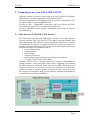
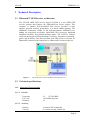
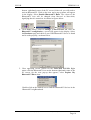
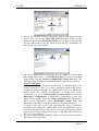
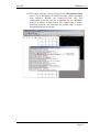
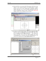
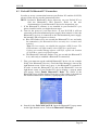
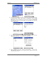
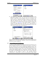
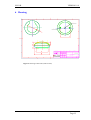
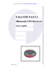
This document is available at HTTP://WWW.FALCOM.DE/ .
FALCOM NAVI-B
(Bluetooth™ GPS receiver)
User Manual
Version: 1.01
NAVI-B
VERSION 1.01
Contents
0
INTRODUCTION ..............................................................4
0.1
GENERAL ABOUT NAVI-B ............................................................................................................. 4
1
SECURITY .........................................................................5
1.1
1.2
1.3
1.4
1.5
GENERAL INFORMATION ................................................................................................................. 5
RESTRICTED USE............................................................................................................................. 5
CHILDREN....................................................................................................................................... 5
DRIVING AND SAFETY ..................................................................................................................... 5
GENERAL CARE AND MAINTENANCE ............................................................................................... 6
2
PREPARING TO USE YOUR FALCOM NAVI-B ........7
2.1
2.1.1
HOW DOES THE FALCOM NAVI-B WORK? .................................................................................. 7
Software interface.......................................................................................................................... 8
3
TECHNICAL DESCRIPTION .........................................9
3.1
3.2
3.2.1
3.2.2
3.2.3
BLUETOOTH™ GPS RECEIVER ARCHITECTURE ............................................................................. 9
TECHNICAL SPECIFICATIONS ........................................................................................................... 9
Electrical Characteristics ............................................................................................................... 9
Physical........................................................................................................................................ 11
Software....................................................................................................................................... 11
4
OPERATION GUIDE......................................................12
4.1
4.1.1
4.2
4.2.1
4.3
4.3.1
INSTALLATION INSTRUCTION ........................................................................................................ 12
Connect the device to power supply ............................................................................................ 13
PC/LAPTOP AND NAVI-B BLUETOOTH™ CONNECTION .............................................................. 13
How to evaluate the NAVI-B connected to PC/Laptop ............................................................... 16
POCKED PCS BLUETOOTH™ CONNECTION .................................................................................. 20
Using the Bluetooth™ GPS Receiver.......................................................................................... 22
5
TROUBLESHOOTING...................................................24
6
HOUSING .........................................................................25
Version history:
Version number
1.00
1.01
Author
Fadil Beqiri
Fadil Beqiri
Change
Initial version
Section 3.2.3 added.
In the section 4.2.1 the sub-point 3)(v) added
This confidential document is the property of FALCOM GmbH and may not be copied or circulated without permission.
Page 2
NAVI-B
VERSION 1.01
Cautions
Information furnished herein by FALCOM are accurate and reliable.
However, no responsibility is assumed for its use.
Please, read carefully the safety precautions.
If you have any technical questions regarding this document or the
product described in it, please contact your vendor.
General information about FALCOM and its range of products are
available at the following internet address: http://www.falcom.de/
Trademarks
Some mentioned products are registered trademarks of their respective
companies.
Copyright
The FALCOM NAVI-B user’s guide is copyrighted by FALCOM GmbH
with all rights reserved. No part of this user guide may be produced in
any form without the prior written permission of FALCOM GmbH.
FALCOM GmbH.
No patent liability is assumed with respect to the use of the information
contained herein.
This confidential document is the property of FALCOM GmbH and may not be copied or circulated without permission.
Page 3
NAVI-B
VERSION 1.01
0 Introduction
0.1 General about NAVI-B
The NAVI-B is a new GPS receiver, integrated with Bluetooth™
technology. With its ultra-low power consumption, it is an outstanding
quality and performance as well as an excellent navigational and positioning
aid tool when used with a GPS Mapping software installed on Bluetooth™enabled devices, such as PC, laptop, or Pocked PC.
The FALCOM NAVI-B has an integrated temperature compensated crystal
oscillators (TCXO). Due to the higher stability of frequency it offers a high
improved performance. Additionally, the integrated TCXO accepts the
condition for use the SiRFXTrac firmware. The FALCOM NAVI-B uses
SiRFXTrac firmware which makes it possible to track the GPS signals at far
lower signal levels than is currently possible with competitive autonomous
GPS solutions. A back-up battery built-in enables the GPS part to perform
Warm and Hot start, which reduce the calculation time for a position fix.
Therefore, you have a high-capacity navigation system, which connects
your Bluetooth™-enabled device with the performance of an intelligent and
dynamic destination guidance. The embedded Class 2 Bluetooth™
transceiver, is capable of communicating with any Serial Port Profile
Bluetooth™ device, within a 10m radius. The NAVI-B in communication
with your installed GPS Mapping software on the Bluetooth™-enabled
device points you the way comfortably and reliably from the current
location A to your desired destination B. In this way you also stay for longer
distances always on the optimal course and arrive your destination point
comfortable and ease. Although your receiver is fully compatible with any
GPS Mapping software running on different hardware platforms. The
embedded high-sensitivity internal GPS and Bluetooth™ antenna allow you
to navigate freely, no more than two wires for connections to the external
supply voltage are available.
The NAVI-B is an equipment that can be used in a variety of applications
including:
♦
♦
♦
♦
♦
Navigation and positioning
Finding streets and routes
Travel planning
Safety and security
Fleet tracking and management and many others … .
This confidential document is the property of FALCOM GmbH and may not be copied or circulated without permission.
Page 4
NAVI-B
VERSION 1.01
1 Security
This chapter contains important information for the safe and reliable use of
the NAVI-B. Please read this chapter carefully before starting to use the
NAVI-B.
1.1 General information
The Global Positioning System uses satellite navigation, an entirely new
concept in navigation. GPS has become established in many areas, for
example, in civil aviation or deep-sea shipping.
The GPS system is operated by the government of the United States of
America, which also has sole responsibility for the accuracy and
maintenance of the system. The system is constantly being improved and
may entail modifications effecting the accuracy and performance of the GPS
equipment.
1.2 Restricted use
Certain restrictions on the use of the NAVI-B may have to be observed on
board a plane, in hospitals, public places or government institutions,
laboratories etc. Follow these instructions.
1.3 Children
Do not allow children to play with the NAVI-B. It is not a toy and children
could hurt themselves or others. The NAVI-B consists of many small parts
which can come loose and could be swallowed by small children.
Thoughtless handling can damage the NAVI-B.
1.4 Driving and safety
Do not place (mount) the device on the parts which will obstruct the sight of
the driver.
Do not place (mount) the device on the parts which block any safety device
(such as the Airbag, pedals, accessory controls and any others) in your
vehicle.
Your own personal judgment has always priority while you driving, if the
user of FALCOM NAVI-B feels that the instructions of navigation software
place you in an unsafe area, then use your personal judgment according to
traffic regulations and do not follow those instructions.
The NAVI-B is designed to be installed inside the vehicle. Do not place or
install the NAVI-B on the vehicle roof (outdoor).
Please, do not handle the NAVI-B while driving.
Safety to traffic has always priority! Please use the FALCOM NAVI-B only
in such a way that you always keep control of your vehicle in all traffic
conditions, especially when the vehicle is moving.
This confidential document is the property of FALCOM GmbH and may not be copied or circulated without permission.
Page 5
NAVI-B
VERSION 1.01
1.5 General care and maintenance
In order to ensure the best performance of your FALCOM NAVI-B, please
remind the following helpful tips:
♦ Keep your FALCOM NAVI-B dry. Do not expose to rain, water, or high
humidity environments.
This confidential document is the property of FALCOM GmbH and may not be copied or circulated without permission.
Page 6
NAVI-B
VERSION 1.01
2 Preparing to use your FALCOM NAVI-B
Read this manual in order to begin using your FALCOM NAVI-B and to
understand its operations, functions, and common features.
You must first install a GPS Mapping software (if none is installed) on your
PC, laptop, PDA, or other handheld devices.
In order to have a Bluetooth™ connection with your Falcom NAVI-B,
secure that the control device is a Bluetooth-enabled one.
For more information about software installation, please refer to chapters
described below.
2.1 How does the FALCOM NAVI-B work?
The FALCOM NAVI-B using SiRFXTrac software offers high position
accuracy and fast Time-To-First-Fix (TTFF) than is currently possible with
other autonomous GPS solution. This means that the NAVI-B will continue
to determinate its positions or obtain an initial fix in places previously not
possible. In other word the NAVI-B can be used in environments previously
deemed inaccessible environments such as:
severe urban canyons,
parking garages,
dense foliage,
multi-level freeways,
under bridges and overpasses, and, in many cases, indoors.
Coverage - Single Story Office Block
When the GPS receiver is initially turned on, it begins to determinate its
current positions, velocity and time which will be calculated from tracking
the GPS signals an extremely small level by 16 dBHz. While trying to
calculate a position fix, the receiver needs to be locked-on to at least four
satellites. In order to calculate quickly its current location, the receiver uses
the current received signals from in view satellites, simultaneously holds the
stored data from its memory (SRAM).
This confidential document is the property of FALCOM GmbH and may not be copied or circulated without permission.
Page 7
NAVI-B
VERSION 1.01
When the required data are completely collected, then satellite signals are
tracked continuously and the position is calculated from time to time. When
the received data from satellites is considered valid then the FALCOM
NAVI-B is available for navigation. The validity of these data stored in
SRAM is kept due to RTC keeps running from external battery and these
data may still be valid form the previous operation.
As above the initial state of the NAVI-B GPS receiver refers to the last
status of the receiver in memory (SRAM). This primarily determines the
length of time it will take for your FALCOM NAVI-B to obtain a GPS fix.
Your position can be extremely quick fixed within 4 seconds from a "hotstart" state, and within 45 seconds from a "cold-start" state. The FALCOM
NAVI-B stores data about where the satellites are located at any given time.
The data is called almanac. Occasionally, when the FALCOM NAVI-B has
been turned off for a long time, the almanac may get out-dated or “cold” so
the NAVI-B performs a cold start. Otherwise, if the time and position are
known, as well the almanac data are also valid then the FALCOM NAVI-B
performs a Hot start.
The NAVI-B uses the satellite signals to calculate its exact current location
by calculating its distance from the satellites. The position data within the
receiver is then converted into latitude and longitude coordinates which are
usually provided in the geodetic datum on which the GPS is based (WGS84)
and transmitted via integrated Bluetooth™ transceiver direct to the
Bluetooth™-enabled device (PC, laptop or Pocked PC).
2.1.1
Software interface
The NAVI-B evaluation receiver is capable of outputting data in the
NMEA-0183 format as defined by the National Marine Electronics
Association (NMEA), Standard for Interfacing Marine Electronic Devices,
Version 3.00, January 1, 1997.
2.1.1.1 NMEA output messages
The table below shows all NMEA output messages supported by NAVI-B
as well as a brief description of each output message.
For more detailed information about the output message list, please refer to
the SiRFstarII message set specification available in section
“service/downloads/manuals” on Falcom’s Website: www.falcom.de.
Option
Description
GGA
GLL
GSA
Time, position and fix type data.
Latitude, longitude, UTC time of position fix and status.
GPS receiver operating mode, satellites used in the position solution and DOP
values.
GSV
The number of GPS satellites in view satellite ID numbers, elevation, azimuth
and SNR values.
RMC
Time, date, position, course and speed data.
VTG
Course and speed information relative to the ground.
Table 1:
NMEA Output Messages
Info: Please note that all supported NMEA messages of the NAVI-B can be
configured via the SiRFdemo software (See chapter 4.2.1). All user
defined settings are kept into the SRAM memory and available on
each power up.
This confidential document is the property of FALCOM GmbH and may not be copied or circulated without permission.
Page 8
NAVI-B
VERSION 1.01
3 Technical Description
3.1 Bluetooth™ GPS Receiver architecture
The NAVI-B OEM GPS receiver from FALCOM is a new OEM GPS
receiver product that features the SiRFstarII-Low Power chipset. This
complete 12 channel, WAAS-enabled GPS receiver provides a vastly
superior position accuracy performance in a much smaller package. The
SiRFstarII architecture builds on the high-performance SiRFstarI core,
adding an acquisition accelerator, differential GPS processor, multipath
mitigation hardware and satellite-tracking engine. The NAVI-B delivers
major advancements in GPS performance, accuracy, integration, computing
power and flexibility. The delivered data from GPS receiver will sent via
Bluetooth™ antenna to the control device (Bluetooth™ connected device).
Figure 1:
The architecture of NAVI-B Bluetooth™ GPS receiver
3.2 Technical specifications
3.2.1
Electrical Characteristics
3.2.1.1 General
Frequency
C/A code
Channels
L1,
1575.42 MHz
1.023 MHz chip rate
12
3.2.1.2 Accuracy
Position
Velocity
10 meters CEP without SA
0.1 meters/second, without SA
This confidential document is the property of FALCOM GmbH and may not be copied or circulated without permission.
Page 9
NAVI-B
VERSION 1.01
Time
1 microsecond synchronized to GPS time
3.2.1.3 DGPS Accuracy
Position
Velocity
1 to 5 meters, typical
0.05 meters/second, typical
3.2.1.4 Datum
WGS-84
3.2.1.5 Acquisition Rate
Hot start
Warm start
Cold start
< 4 sec., average
< 35 sec., average
< 45 sec., average
3.2.1.6 Sensitivity *
Tracking
Hot Start
Warm Start
Cold Start
*
16 dBHz
23 dBHz
28 dBHz
32 dBHz
The sensitivity value is specified at the correlator. On a NAVI-B Evaluation Receiver
using SiRFXTrac firmware, 32 dBHz is equivalent to -142 dBm or -172 dBW.
3.2.1.7 Dynamic Conditions
Altitude
Velocity
Acceleration
Jerk
18,000 meters (60,000 feet) max.
< 515 meters/second (1000 knots) max.
4 g, max.
20 meters/second³, max.
3.2.1.8 DC Power
Main power
Continuous mode
Backup power
+10 to +32 V DC ±5 %
45 mA at 12 V DC
RTC backup (+3 V DC)
3.2.1.9 Bluetooth™ Serial Port
Connection :
Protocol messages:
Serial port settings:
Communicate with Host Platform via
Bluetooth™(Class 2) Serial Port Profile.
SiRF binary – position, velocity, altitude,
status and control.
NMEA, Msg.: GGA, GLL, GSA, GSV,
RMC and VTG
Baud Rate: up to 115200 bps
Data bits:
8
Parity:
NO
Stop bit:
1
Flow control: NO
This confidential document is the property of FALCOM GmbH and may not be copied or circulated without permission.
Page 10
NAVI-B
3.2.2
VERSION 1.01
Physical
♦ dimensions:
weight:
♦ cable length:
♦ temperature range:
3.2.3
52 mm (diameter) x 20 mm (high)
(without cable)
67,8 g
2.5 m
-40 to +85 °C
(operation, transportation and storage)
Software
♦ Software Update:
A firmware update is not possible on the
NAVI-B because the XTrac firmware does
not support any function to set the Boot-pin
of GPS receiver to HIGH via software.
3.2.3.1 TCXO-Specification
Typical phase noise density
Typical phase noise density
Typical phase noise density
Typical phase noise density
Typical phase noise density
Load sensitivity
Long term stability
1 Hz offset
10 Hz offset
100 Hz offset
1 kHz offset
10 kHz offset
± 10% load change
Frequency drift over 1 year
-57.0 dBc/Hz
-88.0 dBc/Hz
-112.0 dBc/Hz
-130.0 dBc/Hz
-140.0 dBc/Hz
0.2 ± ppm
0.5 to 2.0 ± ppm
This confidential document is the property of FALCOM GmbH and may not be copied or circulated without permission.
Page 11
NAVI-B
VERSION 1.01
4 Operation Guide
Before using the NAVI-B, make sure to prepare following:
♦ A GPS software is properly installed on your Bluetooth™-enabled
device (PC, laptop, PDA, or other handheld devices).
♦ The Bluetooth™ GPS Receiver is fully powered and operational.
♦ Check that the Bluetooth™ GPS Receiver is ON.
This section will outline the procedures necessary for the Bluetooth™ GPS
receiver to run smoothly with the GPS software.
4.1 Installation instruction
The position of the antenna mounting is crucial for an optimal performance
of the GPS receiver. The antenna must have full view to the sky ensuring a
direct line-of-sight with as many visible satellites as possible.
a) Use the enclosed cleaning cloth. Clean the side of the part, where the
receiver is supposed to be installed. Note that, the length of extended
cable of the NVAI-B is 2.5 m.
b) The signal receiving side is on the bottom of NAVI-B.
c) There are an adhesive pad and a Velcro pad included, required for onglass mounting. Both pads contain two mounting surfaces. One of
them has to be stuck on the bottom side of the receiver and the another
one on the cleaned area. Both surfaces of pads are protected by
stickers.
d) Remove the protecting sheet from one surface of pad. Mount that
surface onto the bottom side of receiver. Remove the other protecting
sheet from mounted adhesive or Velcro pad (which is required to be
used). Place the bottom side of NAVI-B onto cleaned area and press
the NAVI-B to avoid air bubbles between contact surfaces. The
Velcro pad can also be separated in two parts.
Hints
♦
♦
♦
♦
Proper functionality requires on-glass-mounting
Do not install the device on metallic or coated windows
To be installed in-door on the immovable parts.
NAVI-B is not water resistant. Do not contact it with water.
This confidential document is the property of FALCOM GmbH and may not be copied or circulated without permission.
Page 12
NAVI-B
4.1.1
VERSION 1.01
Connect the device to power supply
Extend the cable and connect it to the power supply, the pin out on the
RJ11 6/2 of NAVI-B is described in the table below.
Pin
Name
I/O
Colour
Description
Level
1
NC
-
-
Not connected
-
2
GND
-
Green
Ground
-
3
NC
-
-
Not connected
-
4
NC
-
-
Not connected
-
5
V+
I
Red
Power supply
+ 10 to +32 V DC
6
NC
-
-
Not connected
-
4.2 PC/Laptop and NAVI-B Bluetooth™ Connection
To set up a connection between PC (in this case running Windows 2000,
WIDCOM Bluetooth™ software Rev. 1.4.1 as well as a Typhoon
Bluetooth™ USB adapter) and the NAVI-B, please follow step by step the
instructions below.
2. If the Bluetooth™ software is not installed in your control device yet,
please install it, plug your Bluetooth™ USB adapter into one of the free
USB COM port before you begin the next steps.
3. If your NAVI-B is still not powered up, please power it up. Once the
Bluetooth™ receiver is turned on, the internal LED will appear as
shown:
♦ Blue LED flashes every one second (the Bluetooth™ is on, and ready
for connection). (The Bluetooth™ LED is internally but is viewable when
it flashes.)
3. Activate Bluetooth™ on your PC. Open the Bluetooth™ install
directory and double-click on its icon. If the Bluetooth™ icon on the
This confidential document is the property of FALCOM GmbH and may not be copied or circulated without permission.
Page 13
NAVI-B
VERSION 1.01
bottom right-hand corner of the PC screen is blue-red, you will need to
activate Bluetooth™. Click on the icon, and a pop-up menu will appear
in the display. Select Enable Bluetooth™ Ratio. The colour of the
Bluetooth™ icon will be changed from blue-red to blue-white,
signifying that it is turned on. As shown in figures below:
►
►
4. Click Start button, point to Settings, Control Panel and click the
Bluetooth™ configuration, a screen will appear in the display. Select
the Hardware page and check if your USB Bluetooth™ device is found
and it works properly, as shown below.
5. Close appearing screen. Search for the FALCOM NAVI-B. Right
mouse click the Bluetooth™ icon on the bottom right-hand corner of the
PC screen. On the next pop-up that appears, select Explore My
Bluetooth™ Places item.
Double-click on the marked icon to find the Bluetooth™ devices in the
Bluetooth™ neighbourhood.
This confidential document is the property of FALCOM GmbH and may not be copied or circulated without permission.
Page 14
NAVI-B
VERSION 1.01
6. After a few seconds, a list of Bluetooth™ devices will appear on your
screen. You will see the FALCOM NAVI-B appear in the Service
Selection. Select the FALCOM NAVI-B icon. In order to discover the
services offered the FALCOM NAVI-B click the link ‘click here’ on
the left side of opened window..
7. The service appears below allows the users to establish a virtual serial
port. Right-click on the ... FALCOM NAVI-B icon, on the appearing
popup menu click the Connect to Bluetooth™ Serial Port item. The
LED blue lights constantly (means Bluetooth™ connection is created).
Secure Connection:
As far as the Secure Connection for NAVI-B is concerned there is no
security entered i.e. there is no device pairing required if the Secure
Connection option is disabled for a Bluetooth™ service or application.
Please check the software configuration to disable the Secure
Connection (e.g. go to Start>Settings>Control Panel and click the
Bluetooth™ configuration, a Bluetooth™ configuration screen will
appear in the display. Select the Client Application tab, then doubleclick on the Application Name “Bluetooth™ Serial Port” and
deactivate its Security Connection on the next appeared dialog box).
In order to pair two devices with each-other the Secure Connection
option has to be enabled for a Bluetooth™ service or application (e.g. go
to aforementioned directory and activate its Security Connection). After
inquiry process, the pairing process needs a valid PIN which for NAVIB is “1111” pre-defined.
8. For more details about Bluetooth™, please refer to the software manual
that you are currently using.
This confidential document is the property of FALCOM GmbH and may not be copied or circulated without permission.
Page 15
NAVI-B
VERSION 1.01
9. In order to see the signal strength of Bluetooth™ connection, right-click
on its icon, on the next appeared pop-up menu select the Status item.
The signal strength is at the bottom of the appeared screen indicated. Try
experimenting with your Bluetooth™ GPS receiver to see how far it
needs to be before the blue bar reaches. If the user right-clicks the icon
again and selects the Properties item an available COM Port is selected.
►
4.2.1
How to evaluate the NAVI-B connected to PC/Laptop
After the Bluetooth™ connection is established, please download the
SiRFdemo software which is free available on Falcom’s Website:
www.falcom.de/service/downloads/manual/SiRF/ SiRFdemo3.36.exe
1) Run the SiRFdemo software by double clicking the SiRFdemo3.36.exe
file. The SiRFdemo program will be automatically installed onto your
computer.
2) To start the SiRFdemo software, either double-click on the
SiRFdemo3.36.exe installed file or if you have created a shortcut on your
desktop, double-click the SiRFdemo3.36.exe.
3) The SiRFdemo software will be appeared as follow:
This confidential document is the property of FALCOM GmbH and may not be copied or circulated without permission.
Page 16
NAVI-B
VERSION 1.01
(i) Before running the software, make sure that your PC is
recognizing the NAVI-B properly. In order to receive the valid
positions for the current location of the device, please place it so
that the receiver can have clear view to the sky.
On the activated Data Source Setup window, select the COM
(e.g. COM9) for SiRFdemo program and set the baud rate to 4800
bps. See figure below:
(ii) Click the icon on toolbar by the up-down button (marked button
in figure below) the program will automatically detect the
selected COM port and starts evaluating.
This confidential document is the property of FALCOM GmbH and may not be copied or circulated without permission.
Page 17
NAVI-B
VERSION 1.01
(iii)The output messages can be viewed in the Development Data
screen. For a description of NMEA messages please download
from Falcom’s Website the “SiRFmessages.pdf” file. The
valid/invalid protocols can be recognized on the $GPRMC
protocol as shown in figure below. The capital letter A means,
incoming protocols are valid and the capital latter V means,
incoming protocols are invalid.
This confidential document is the property of FALCOM GmbH and may not be copied or circulated without permission.
Page 18
NAVI-B
VERSION 1.01
(iv) If the NAVI-B is receiving valid GPS positions, click the icon on
toolbar by the up-down button (see marked button in figure
below), the user can see the updated data of longitude, latitude,
altitude, date time etc. For more detailed information about the
using of SiRFdemo software, please download the SiRFdemo.pdf
manual, which is also available on our web page.
(v) In order to set the desired update rate of the supported NMEA
protocols, click the Action menu on the Main Menu, then select
the item Switch to the NMEA Protocol …. The dialog box
below will appear. Now select the required update rate in the
corresponding box of protocol and click the Send button. The
result will be displayed on the Development Data screen.
This confidential document is the property of FALCOM GmbH and may not be copied or circulated without permission.
Page 19
NAVI-B
VERSION 1.01
4.3 Pocked PCs Bluetooth™ Connection
In order to set up a connection between your Pocket PCs and the NAVI-B,
please, follow step by step the instructions below.
HINT: Perform a Bluetooth™ device discovery on your Pocked PCs to
find the Bluetooth™ GPS Receiver. Refer to the user
documentation of your Bluetooth™ device for instructions, too.
1. If the Bluetooth™ software is not installed in your Pocked PCs yet,
please, install it before you begin the next steps.
2. Turn on the power to your host device. If your NAVI-B is still not
connected to the aforementioned power supply, then connect it. Once the
Bluetooth™ receiver is connected to the aforementioned power supply,
the internal LED will appears as shown:
♦ Blue LED fashes every one second (the Bluetooth™ is on, and ready
for connection). (The Bluetooth™ LED is internally but is viewable when
it flashes.)
Note: For best results, you should also perform a GPS fix now. The
GPS indicator will light steadily when a GPS fix is performed.
If there are troubles during acquire a GPS fix, replace the location
of NAVI-B or switch it off and on again.
♦ The Bluetooth™ indicator flashes every one second (the Bluetooth™
is on, and ready to establish a Bluetooth™ connection)
3. First, you must turn on the enabled Bluetooth™ device (in our example
iPAQ 38xx Bluetooth™ device). Check the Blue Manager's icon on the
right-bottom screen. If the icon is grey i.e. the Bluetooth™ is turned off.
In order to turn the Bluetooth™ on, tab on the Bluetooth™ icon on
right-down corner of your Pocked PCs device display, a pop-up menu
will appear. Select Enable Bluetooth™ Ratio. The colour of the
Bluetooth™ icon will be changed from grey to blue-white (it depends on
the installed Bluetooth™ software), signifying that it is turned on.
4. Search for the FALCOM NAVI-B. Open the Bluetooth™ popup menu
on the right-bottom screen. Tab on the Bluetooth™ Manager.
This confidential document is the property of FALCOM GmbH and may not be copied or circulated without permission.
Page 20
NAVI-B
VERSION 1.01
5. If you have not searched for devices since last search, tap Search menu
at bottom (below right). After search is completed, a list of found
Bluetooth™ devices will appear on your screen. Check the FALCOM
NAVI-B found (below left) and tap Save. Then tab OK on the following
(below right) screen.
6. You will be returned to the Bluetooth™ Manager screen. Tab the
FALCOM NAVI-B icon to get the device information.
7. Tap on Actions menu and "Connect to GPS_NMEA .." (below left).
This will take a short time to be completed (below right). Now tap OK
to return to Devices list.
This confidential document is the property of FALCOM GmbH and may not be copied or circulated without permission.
Page 21
NAVI-B
VERSION 1.01
8. Your last step is to find which serial port is connected to. At the main
Bluetooth™ Manager screen, tap Tools Menu and "Settings for All
Devices" (below left). On the Settings screen, tap "Serial Port" tab.
Note the entry for "Outbound Com Port" (COM8 in screenshot below
right) and “Inbound Com Port” (COM7 in screenshot below right).
As far as the Secure Connection for NAVI-B is concerned, please, refer
to the chapter 5.2 (click here). If the option “Passkey is required” is
selected, see figure right below, then enter “1111” when asked for a
passkey for the device. For more details about Bluetooth™, please refer
to the software manual that you currently use)
When the FALCOM NAVI-B Bluetooth™ GPS receiver is connected to
handheld device, the Bluetooth™ indicator on the NAVI-B Bluetooth™
GPS receiver will be steadily on.
4.3.1
Using the Bluetooth™ GPS Receiver
As soon as you have installed and configured the Falcom NAVI-B on your
mobile equipment (Pocked PCs), the inserting of navigation is anymore in
the way. You have just to run the installed GPS Mapping software. The
Bluetooth™ connection for the installed GPS Mapping software must be set
to the correct COM port (please refer to the user documentation of the
installed GPS Mapping software for instructions). Determine which COM
port number your Bluetooth™ device does it use for serial COM port
connections (in our example is COM 7). The FALCOM NAVI-B
communicates to a Bluetooth™ serial port with following settings: up to
This confidential document is the property of FALCOM GmbH and may not be copied or circulated without permission.
Page 22
NAVI-B
VERSION 1.01
115200 bps, 8 Data Bits, NONE parity, 1 Stop Bit. Depending on the
device you use for Bluetooth™ connectivity, you may or may not need to
modify the COM port setting. If necessary, refer to the user documentation
of your Bluetooth™ device. In order to navigate to your destination, please,
refer to the user documentation of installed GPS Mapping software for
instructions. There you will find exactly explained the methods for setting
the destination and following the navigation instructions to travel to your
destination.
We wish you much fun and have a good trip with your FALCOM NAVI-B.
!! Please remember that:
Safety to traffic has always priority! Please use the FALCOM NAVI-B only
in such a way that you always keep control of your vehicle in all traffic
conditions.
This confidential document is the property of FALCOM GmbH and may not be copied or circulated without permission.
Page 23
NAVI-B
VERSION 1.01
5 Troubleshooting
Q: The installed software does not seem to establish any connections
with NAVI-B. How do I make it work?
A: Make sure that your Pocked PC has found the "FALCOM NAVI-B"
Bluetooth™ device. Follow the instructions in the Connection section
to make sure that your Pocked PC has recognized the Bluetooth™ GPS
receiver properly. If so, you will need to connect with the device by
going to the Bluetooth™ Manager and tab on the on Actions button and
then "Connect to GPS_NMEA ..".
Q: I have established a Bluetooth™ connection but the NAVI-B does
not seem to have any GPS fix, what should I do?
A: Disconnect the NAVI-B from the external power supply and connect it
again. Change the location of NAVI-B (maybe poor signals were being
received), but in accordance with the capability of Bluetooth™
communication.
Q: The FALCOM NAVI-B seems to have a GPS fix (GPS indicator is
steadily light), but unable to establish a connection between the
NAVI-B and my Pocked PC. How can I perform a connection?
A: Go to the Bluetooth™ Manager → All devices on your Pocked PC. Tap
Actions menu and then "Remove this Device".
Next, shutdown your FALCOM NAVI-B by pressing the On/Off button
approx. 2 second. Then perform a soft reset on your Pocked PC.
Once your Pocked PC has finished resetting itself, go back to the
Bluetooth™ Manager screen and perform the typical setup and
connection procedures for your Bluetooth™ receiver (for help with
connection, please review the Connection section).
Finally, run the installed GPS Mapping software, select the assigned
COM Port from Bluetooth™ connectivity, set the baud rate up to
115200 bps (you may or may not need to modify the COM port setting,
it depends on your using Bluetooth™ device), and click Open Port. The
current position will appear on the GPS Mapping software.
This confidential document is the property of FALCOM GmbH and may not be copied or circulated without permission.
Page 24
NAVI-B
VERSION 1.01
6 Housing
1
2
3
4
5
6
7
8
A
A
5.5
B
B
2.2
47
C
C
32.2
D
D
E
Savety due to DIN 34
Tolerance
Scale
F
DIN 16 901
MFR 200/5: 4...8g/10 min.
Volume
in mm
Weight
created
4044
4,33
g
Name
10.04.03
Material
Surface
ABS
see above
Flamebility UL94 HB
mm^3
Date
PANTONE : 426 C
RAL 9004
Colour
130
class:
2:1
Dimensions
Name
Lockner
Housing of NAVI-B
checked
Dwg No.
std check
1
2
3
4
Project
GPS-Mouse
CL-No.
Version
0197 21 02-00
file
Figure 2: Housing of NAVI-B (without cable)
This confidential document is the property of FALCOM GmbH and may not be copied or circulated without permission.
Page 25
Sheet
1/1