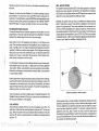
1
UltraNav II
INSTALLATION AND OPERATION
INSTRUCTIONS
LITHO IN U.S.A.
988-0135-02
E&GI Ek1
PDF compression, OCR, web-optimization with CVISION's PdfCompressor
SONARSPECIFICATIONS
UltraNav II Dimensions
Input Voltage
Current
WARNING!
USE THIS GPS RECEIVER ONLY AS AN AID TO NAVIGATION. A
CAREFULNAVIGATOR NEVER RELIES ON ONLYONEMETHOD TO
OBTAINPOSITION INFORMATION.
Transmitter
Frequency
Output Power
(typical)
Display Size
Pixels
5.875"H x 7.75Wx 3.875"D
10-15 vDC
500 ma (lights off)
650 ma (lights on)
192kHz
600 watts (peak-to-peak)
75 wafts (RMS)
2.8"H x 3.5W
128Hx160W
20,480 Total
CAUTION
This OPS receiver, (like all GPS navigation equipment) will show the
shortest, mostdirectpathto a waypoint. It provides navigation datato the
waypoint regardless of obstructions. Therefore, the prudent navigatorwill
not onlytake advantage of all available navigation toolswhen
to
awaypoint,butwillalso visually checktomake certain aclear,travelling
safepath to
thewaypoint is always available.
NOTICE!
Asofthis writing,the Department of Defense (DOD) has notdeclaredthe
GPSnavigation systemoperational. Thesystem is still in a
testingphase.
Satellites canbeturned offoracburacycan be degradedatwill bythesystem
operators.Remember that the UltraNav II, or any GPS receiveris onlyas
accurateas thesystemit's using.
UltraNav II GPS RECEIVER SPECIFICATIONS
GPS Module Dimensions
2.5"H x4.1"Wx7" D
Channels
Five Parallel
Four continuous for position
All satellites in viewtracked
Onesecond
Update rate
Maximum accuracy achievablewith
Accuracy
Position
Velocity
Standard Positioning Service
25 meters CEP
0.25 meters/sec AMS
Without SA PDOP.c6.0
NMEA 0183 SENTENCES
RMB
Minimum Recommended Sentence, Part B
RMC
Minimum Recommended Sentence, Part C
GLL
PresentPosition - Latitude/Longitude,
APB
Autopilot Steering Data
DBT
Water Depth
MTW
WaterTemperature (oC)
VHW
Speed Through Water (KPH)
VLW
Distance Travelled/LOG (NM)
Copyright0 1993 EagleElectronics
All rights reserved.
All featuresand specifications subjectto changewithoutnotice.
All screens in this manual are simulated.
79
PDF compression, OCR, web-optimization with CVISION's PdfCompressor
OPS MODULE SELF-TEST
This feature tests the GPS
module and returns a special
Code. This Code Is of interest
only to the service department.
However, the UltraNav II interprets this code and displays a
statusmessage. Thismessage
is either "GPS MODULE
.fl
PBIT SUMMARY
SELl. TESTI .:fl
LOW ORDER RAM
HIGH ORDER RAM
PRE PROCESS TEST
PRE PROCESS RAM
MULTI INTERFACE
UCO TEST
0000
FEET
rrrr
0000
FETE
0000
0000
0000
SIGNfL INJ.
3.20
OFTWARE VERSION
CLEARI MUE'ULE.:. HASiFA%E
PASSED" or "OPS MODULE
FAILED" and shows atthe bottom of the screen. The current
software version number also appears near the bottom of the screen.
Contactthefactotycustomerservice departmentif the modulefailstheselt
test. Do not attempt to use this product if it fails the self test.
.c
To usethe selftestfeature, press the MENU keytwicewhileit'sinthe GPS
mode,then press the key next to the "GPSMODULE SELF TEST" label.
The screen shown below appears.
To exit from this screen, press the CLEAR key.
OPS SIMULATOR
This feature place.s position and navigation data on all screens, including
the plotter. The unit s:navigatesJ a closed course. It shows bearing and
distance to go, course over ground, and other information. A recurring
message appears, alertingyouthat the simulator mode is enabled. Don't
navigate when the simulator is onl
To turn thesimulator on, press the MENU key twice, then press the key
nexttothe"GPS SIMULATOR OFFON" label. The simulator mode starts
immediately. To turnthe simulator off, either press and hold the OFF key
or repeatthe above steps. Press the key nextto the "GPS SIMULATOR
OFF ON" label.
TABLE OF CONTENTS
INTRODUCTION
MOUNTING
POWER CONNECTIONS
GPS MODULE INSTALLATION
TRANSDUCER
KEYBOARD BASICS
DISPLAY
MENUS
HELP
WINDOWS
VIEWING WINDOWS OPTIONS
SIDE SCAN OPERATION
SONAR OPERATION
AUTOMATIC
SENSITIVITY
RANGE
ZOOM Automatic Operation
ZOOM Manual Operation
MENU-PAGE I
CHART SPEED
2
3
6
6
8
8
9
9
11
ii
12
12
is
¶4
14
14
16
is
16
17
18
-
GRAYUNE®
FISH I.D
DISPLAY CONTRAST
SONAR ALARMS
FISH ALARM
ZONE ALARM
DEPTH ALARMS
MENU-PAGE2
ADJUST BACK LIGHT LEVEL
BACK LIGHT ON/OFF
SPEAKER VOLUME
TURN DIGITALBOX OFF
CONSTRUCT DIGITAL BOX
MENU-PAGE3
CHART CURSOR
DISPLAY ZOOM BAR
DISPLAY ZONE BAR
DIGITAL SONAR
TURN ALL SONAR OFF
MENU-PAGE4
FASTRAK
SELECTUNITS OF MEASURE
CLEAR DISTANCELOG•
MENU-PAGES
ADJUSTCHARTSURFACE CLARITY
ADVANCED SIGNALPROCESSING(ASP)
MENU-PAGES
ADJUST KEEL OFFSET
CALIBRATE SPEED
PRESET SONAR AND GPS
TRANSDUCERS AND CONE ANGLES
FISH ARCHES
WATER TEMPERATURE AND THERMDCLINES
SURVEYINGA LAKE
78
1
.
19
¶9
20
21
23
23
23
23
24
24
25
25
25
26
26
26
27
27
27
28
28
28
29
29
30
31
31
BAIT FISH
32
32
34
35
36
SONAR TROUBLESHOOTING
37
PDF compression, OCR, web-optimization with CVISION's PdfCompressor
TosetthePCFfactor, firstpress
the MENU key, then press the
key nexttothe"CHANGE GPS
SETTINGS" label. Now press
the key next to the "ADJUST
PCF OFFSET' label. The
screen shown on the previous
9r
jgJt ion Correction
UOOOaOOO
0OO,OOO'
IUSE
I
NUMERIC KEYS
I
page appears.
TO CHANGE VALUE
UP="H"
Now press thekey adjacent to
the "CHANGE OFFSET" label
to eriterthecorrectionfactorfor
DN="S"
l
SEPT
your location. The screen shown above appears. Remember, this is the
difference between the location shown on the present position display and
the positionshown on the chart.
Position Correction
Factor
Lc4T OFFSET: N
LON OFFSET: E
O0OOO12
U°OO.068'
Usethe right and leftarrow keys
to move the black box to the
numberthatyou wishtochange
in the latitude, then enter the
numbers.
Use the up or downarrow keys
tochangethe latitudefrom north
to south, if necessary. Press
the key next to the "ACCEPT"
label when you've entered the
desired latitude offset. Repeat
this procedure to change the
longitude. In this example, we have entered .012 degreesnorth lattitude
and .068 degrees eastlongitude as the PCFoffset. That is the difference
between the presentposition shown on the unitand ourposition shown by
the chart. In otherwords, our position shown on theunit is 0.012 degrees
north and 0.068 degrees east ofthe position shown on the chart.
After you've entered the desired offset, press the key next to the "PCF
OFFSET OFF ON" label. This turns the PCF correction factor that you
entered on. To leavethis screen, pressthe key nextto the "EXIT" label.
This returnstheunittothe last usedGPSscreen. Italsoputsyourchanges
into effect.
To turn thesechanges off, return to this screen and press the key next to
the "PCF OFFSET OFF ON" label. Remember, Presetting the unit also
erases any PCFoffset, thereby turning it off.
77
PDF compression, OCR, web-optimization with CVISION's PdfCompressor
PCF OFFSET
The GPS navigation system relies on complex mathematical calculations
to determine your position based on satellite data and otherfactors. One
factor is the Earthsshape. Sincethe Earth is not atruesphere, variations
in the calculations have to be made to accommodate deviations. To make
matters more complex, not everyone uses the same data to determine
whatthe deviations are. Thesizeandshape of the ellipsoids that are used
to approximate the earth's surface are improved often. This can lead to
errors if your navigation device uses one ellipsoid, whileyour chart uses
a differentone. The term used for these ellipsoids is "Datum."
To reduce the errorfactorbetween datum, this unitgives youthecapability
to moveor "offset" the position shown onthe display to match the one on
the chart. The unitwill add this offset to all position displays at all times.
Remember, the GPS error is very dynamic and the PCF offset should
never be used in an attempt to cancel the error. In general terms this
feature should only be used if your map indicates what the possible error
is. Thisfeatureshould always be reset to zero (0) whenfinishedwith that
chart.
For example, suppose you are stopped at a locationthat is accurately
marked on a chart. Your unit shows a longitude position that is .010
degrees less than the one on the chart. Using the Position Correction
Factor (PCF)Offsetfeature,youmake the unitreadthesameas thechart.
If you move, the unit will continuously add the change to all
position displays. Thismakes it
moreclosely match the datum
LAT OFFSET: N.:,C!PiJO1I1OC.
used by the chart. Forthis reaLOll OFFSET:
son,you should becareful when
entering the PCF offset. This
offset is saved in memory. It
doesn't change whentheunitis
INTRODUCTION
The UltraNav II is a high quality, wide screen combination sonar and
differntial ready OPS receiver with performance that is secondto none in
its class. Using menu featuresand "soft-key" operation, the UltraNav II is
also one ofthe easiest-to-use products that Eagle haseverbuilt.Thewide
"UltravisionTM"screen shows the underwater world with high resolution
and detail. The display and keyboard are also lighted for night operation.
Installing an optional ST-T speed/temperature sensor, gives digital boat
speed, surface watertemperature, and distance travelled (log) displays.
Readthis manual and takeitwith youthe firstfew timesyou useyour unit.
It makes a great reference if you need it.
MOUNTING
Install the UltraNav II in any convenient location, provided there is
clearance behind the unitwhenit istiltedforthe bestviewingangle.Holes
in the bracket baseallowwoodscrew orthrough-boltmounting. You may
need to placea piece of plywood on the back of thin fiberglass panels to
secure themounting hardware. Make certain thereis enoughroom behind
the unitto attach the power and transducer cables.
The smallest holethat will passone power ortransducerplug is one inch.
Afterthe holeis drilled, passthe transducerconnector up throughthehole
first, then passthepowercable down through it.
Position Correctq
Factor
turned off. However, a Preset
does erase the PCF factor.
SLOT
Afterthe cables have been routed, fill the holewith a good marinesealing
compound. Offsetthe bracket to cover the hole. Routethe power cable
through the slot and break out one ofthe other slots in the bracket forthe
transducer cable.
76
1
PDF compression, OCR, web-optimization with CVISION's PdfCompressor
POWER CONNECTIONS
The UltraNav I! works from a twelve-volt battery system. For the best
results, attach the power cable directly to the battery. You canattach the
power cable to an accessory or power buss, however you may have
problemswith electrical interference. Therefore, ifs saferto go ahead and
attach the powercabledireotlytothebattery. Ifthe cable istoo short,
splice
#18 gaugewire onto it. The powercablehasfour
wires; red, black, green,
and white. Red is the positive lead, black is negative or ground. Make
certainto attach thein-linefuseholdertothered leadas closetothe
power
sourceas possible. Forexample, if you haveto extend the
powercableto
thebatteryorpower buss, attach one end of the fuse holder directlytothe
batteryor power buss.Thiswill protect both theunitandthepowercable
in the eventof ashort. The UltraNav II usesa
3-ampfuse.Thereis reverse
polarity protection built into the UltraNav II. If the power wires are
connectedbackwards, no damage will occurto the unit.
IMPORTANT!
Do not use this productwithouta 3-amp fuse wired into the
powercable!
Failureto use a 3-ampfuse will void your warranty.
Ifyou'reinstalling an optional speed/temperature sensor, read thespeed/
temperaturesensor's installation manual formounting instructions. Route
the sensor's cable to the UltraNav Il's power cable and plug it into the
connectormarked "SPEED/TEMP CABLE'
TOP" CONNECTOR
The plotter display automatically shows a .1 mile display in the Man
Overboard mode. Your position when the Marl Overboard key was
pressed is shown by the "S' with a circle and by the waypoint icon with a
"0" Steerto the waypoint flagto get backto the position saved when the
Man Overboard key was pressed.
IMPORTANT!
The UltraNav II doesn't save the Man Overboard position in thewaypoint
table. However, it does save the position on the Man Overboard screen.
The UltraNav II always shows navigation datato the position shownon the
Man Overboard screen whenever the Man Overboard key is pressed. To
stopthe unitfromnavigating totheMan Overboard position, press the key
next to the "DISABLE MOB" label. This resets the Man Overboard
navigtion.
For example, suppose youare viewing the Position screen, and youpress
the Man Overboard key, then press the OPS key. The UltraNav II first
displaysthen stores your present position on the Man Overboard screen,
thenswitchesbacktothe Position screen. Ifyoupressthe Man Overboard
key again, it will still show navigation data tothe position youwere in when
you first pressed the Man Overboard key - not your present position.
Repeated pressing of the Man Overboard key does not repeatedly save
yourpresentposition!The unitonlysavesthe position thefirsttimethe Man
Overboard key is pressed. To save a new Man Overboard Dostion. you
must first clear the old Dosition by pressing the key adiacent to the
"DISABL MOB" label.
ON ULTRANAVII
You can navigate to a waypoint using the Waypoint Recall feature,
howeverwhenyou go backto theMan Overboard screen, the UltraNavIl
stops navigating to the recalled waypomnt.
Remember, saving the victim is the primarygoal.Try all options to rescue
the person immediately afterthe accidenthappens. Training and educationare also good accident preventatives. TheCoastGuardhas excellent
safety courses. Instruct all members on board your boat on safety
procedures before leaving the dock. Make certain all on board know what
to do beforeany emergency occurs.
TO
SPEEP1
Formoreinformation on savingand recalling waypoints, see"How to Save
a Waypoint" section in this manual.
TEMP
SENSOR
2
75
PDF compression, OCR, web-optimization with CVISION's PdfCompressor
PRESET
ThePresetfeaturereturns all sonar and OPSunitstotheir original factory
settings. This resets the units of measure, speaker volume, automatic
mode onthe sonarside, displaycontrast, andmore. Thisdoesn'teraseany
waypoints or routes, however.
The white wire is for a NMEA interface. The UltraNavII sends data to
anotherelectronic navigation devices throughthe whitewire. The green
wire is for a differential GPS (DGPS) receiver input. If the white and
green wires are not used, tape their ends so that they cannotshort.
To presetthe unit, press the MENU key until the "PRESET UNIT" label
appears. Press thekeynexttothat label.Themenu screen disappears and
the UltraNav II returns tothe OPSposition screen. All units will be returned
to their factorysettings.
To connect a device to the UltraNav's NMEA output (white wire); attach
a two-wire shielded cable from the other device's NMEA intput to the
white and black wires on the UltraNav il's powercable. Solderthe shield
to the black wire on the power cable. Do not connect the shield to the
otherdevice. See theotherinstrument's manual for morewiring instructions. Use the same procedure to connectthe DGPS receivers outputto
the green and black wires on the UltraNav II.
MAN OVERBOARD
Oneof boating's mostterrifying events is having afriendorfamily member
fall overboard. Thissituation can be deadly on anybody of water,fresh or
salt. It's particularly dangerous at night or if you'reout of sight of land. Of
course, the first thing to do is remain calm and try all standard safety
measures to tryand rescuetheperson. Ifyou lose sightof the person, you
can use the UltraNav II to help start a search pattern.
Note: The shielded wire is not absolutelynecessary, howeverit is best
to use it due to the high electrical noise levels found in today's marine
environments. To avoid problems later, we highly suggestthat you use
shielded wires whenever making a communications connection between
two instruments. See the NMEA section in the GPS section in this
manual for more information.
GPS MODULE INSTALLATION
iasmffg
Onceyou're back at the helm
after initial rescue efforts have
failed, press the UltraNav Vs
MAN OVERBOARD key. The
screen shown at right appears.
H 36°09.669'
isiia[
Pfl
UI
9E°37.171'fIsnBLE MOBS
..L
4:26:35
DTI3
BRG
bbs
0.07
3340
3400
FHJ
E
[H]
TTG00:O2:4O
.
S0.11I
Your position atthe timeyoupressedthe Man Overboard key is shown in
the top leftcornerof the display. Beneath the position is the timethat you
pressed the Man Overboard key. At the bottom of the screen are the
navigation data displays showing the Distance (DTG), Bearing (BRG),
Course (COG), and TimeToGo (TTG) backtothe postion atthe top ofthe
display. Using thesedisplays along withthe plotterinthelowerright corner
ofthe display gives youthe information youneed to steer backto the man
overboard position.
74
The GPS thodule can be installed on a flat surface or (withthe supplied
adapter) on a pole. Mountthe module in an areathat guarantees aclear
view ofthe sky at all times. In orderfor the module to receive thesignals
from the satellites, it must not be obstructed. An ideal location is on a
cabin roof, or deck. The gunnels also make a good location. Attaching
the pole mounting adapter lets you in- 17mm
5.5mm (7/32")
stall the module on a one inch mast. (11/16')
Hole
(4 places)
However, for lightning protection, the
Hole
antenna shouln't be the highest part of
the boat.
Surface Mounting - WithAccess
If you have access underneath the
mounting surface, use the gasket supGASKET
plied with the GPS module as a template. Drill four 5.5 mm (7/32a) holes
and one 17 mm (11/16") hole for the
module's cable. Attach the cableto the
module and pass it down through the
hole in the gasket and
mounting DECK
sMMscREws
surface. Use 5 mm screws, flat washers, and lock washers to fasten the
GPS module to the mounting surface. Routethe cableto the UltraNav II.
/
th
.
3
PDF compression, OCR, web-optimization with CVISION's PdfCompressor
Surface Mounting - WithoutAccess
If you don't have access to the back side of the mounting surface, use
the "cleats" supplied with the UltraNav II. (Note: This is
assuming you
can "snake" the module's cableto a location that is accessable. A hole
will still need to be drilled in the mounting surface for the
cable.) Using
the gasket as a template, mark and drill the 17mm
(11/16") hole forthe
cable. Attach the cable to the module .and dropthe other end of the
cable through the gasket and down the hole. Place the module on the
gasket. Slide the "cleats" onto each end of the module and (using the
cleats as templates) mark four holesfor 5 mm (#10)
mounting screws.
Drillthe holes, then replace the cleats on the module and fasten themto
the mounting surface with 5 mm (#10) screws. Route the cable to the
UltraNav II.
"CLEAT"
strength (the higherthe number,the better), andthe signalto-noiseratio (SNR). The highertheSNRnumber, thebetter,
also.
The lower half of the screen
shows statistics for each ofthe
receiver's five channels. This
includes the satellite number
(PRN), its status (STAT), the
User Differential Range Error
(UDRE), Time status (TIME), and if SA (Selective Availablity) is on or off.
The UDRE is the rangeerrorfromyour position to the satellite. If there is
an "OK" inthisfield,then the range errorto that satellite is 8 metersor less
68 percentof the time.
For mOre information, read your beacon receiver's manual.
SELECTUNITS OF
MEASURE
(See the Select Unitsof Measure in the Plotter section of this manual.)
•
DRILL FOUR
PLACES
GA5
TRUE and MAGNETIC POSITION
True and magnetic north are not always the same. True north is the top of
the world. It's where all lines of longitude converge. Magnetic north isthe
location our compasses point. It lies several hundred miles to the south of
true north, at a location in Canada.
Charts are usuallylaid outaccording to aMercatorprojectionthatuses true
north. If you ptot a course on chart usingthe Mercator projection, you'll
either have to convert magnetic readings to true or usetrue readings.
The UltraNav II can display navigation information in magnetic or true.
Whenit's turned on for the first time magnetic is used. To switch to true,
press the MENU keywhilea GPSscreen is displayed. Next, press the key
nextto the"CHANGE GPS SETTINGS" label. Now press the key nextto
the "SELECT UNITS OFMEASURE'label. Nowsimply pressthekeynext
to the "BEARING" label; This moves the black box from"MAG" to "TRU."
Press the key nextto the "EXIT" label whenyou'refinished.
CABLE
4
73
PDF compression, OCR, web-optimization with CVISION's PdfCompressor
DGPS (Differential GPS) BEACON RECEIVER SETUP
You'll have to tell the UltraNav II which beacon receiver's data to expect
and setup the parameters for that data. To do this, first press the MENU
key, then pressthekey nexttothe'CHANGEGPS SETTINGS" label. Now
press the key next to the "SELECT NMEA" label. The screen on the
previous page appears. Pressthe key nexttothedesired beacon receiver.
The beacon receiver is selected, now you'll need to set it up for the
frequency and bit rateof the stationyou'll be using in your area.
Repeatthe above stepsto get the NMEA screen as shown on the previous
page. Nowpress the keynexttothe "SETUP BEACON" label. Thescreen
shown below appears.
The station frequency and bit
rate are shown on the right side
of the screen. Press the key
adjacent to the INC FREQ" to
increase the station frequency
orthe DECFREQ"to decrease
it. Do the same for the bit rate.
(NOTE: For automatic station
selection on the Starlink MRB2A ONLY, set the station frequency to zero and ignore the
bit rate.) When the station frequency and bit rate are adjusted to their
proper settings, press the key next to the "EXIT' label. The UltraNav II
returnstothelast usedGPSscreen. Theletters "DGPS" appear nexttothe
"POSITION" on all screens that show your present position, showing that
the beacon receiver is working.
Toviewthestatus ofthebeacon signal, presstheMENU keyuntil thefourth
menu page appears. Now press the key adjacent to the "DIFFERENTIAL
GPS STATUS" label.Ifthe beacon receiver is receiving data
fromthe transmitter and is connected properly tothe UltraNav
II, a screen similar to the one
shown at right appears.
OK
OK
OK
OFF
15
This page shows the station ID
number, its frequencyand bit
rate, the "health' of the station
(0 = best, 5 = worst), signal
ft
72
02
27
26
OK
OK
OK
BAD
OK
OK
OK
OK
OK
OK
OK
BD
OFF
ON
ON
ON
Pole Mount
First, thread the pole mounting adapter onto the mounting pole or ratchet
base. Align the polemounting adapter so the module will facethe bow of
the boat. Install and tighten theset screw into the polemountingadapter
and tighten it securely. This should prevent the GPS module from
unscrewing from the pole. Place the gasket onto the pole mounting
adapter. Now attach the cable to the GPS module and pass the cable
through the gasket, pole mounting adapter, and pole. Set the OPS
module on top of the pole mounting adapter and align the four threaded
holes in the module with the holes in the pole mounting adapter. Using
the fourstainless steel 5 mm screws and lock washers suppliedwith the
UltraNav II, attach the pole mounting adapterto the OPS module. This
completes the assembly.
ULE
POLE
MOUNTING
ADAPTER
SET
SCREW
POLE
If the pole or mast you're using isn't hollow or if the.hole in the middle of
the pole is too small for the connectors, usethe cable mounting adapter
supplied with your unit. Threadthe cable mounting adapterintothe GPS
pole mounting adapter. Then thread the pole into the cable mounting
adapter. Route the cable down the outsideof the pole.
CABLE
MOUNTING
ADAPTER
CABLE
MOUNTING
ADAPTER
POLE
POLE
5
PDF compression, OCR, web-optimization with CVISION's PdfCompressor
TRANSDUCER CONNECTIONS
See the transducer owner's manual included with the unit for
complete
transducerinstallation instructions.
SIDE SCAN
The UltraNavII has optional side-scan capability. To usethis
feature,you
must purchasetheScanpacaccessory.To install it,followtheinstructions
enclosedwith theScanPac.
See the "Side Scan Operation" sectionin this manual for information on
using the side-scan feature.
SELECTNMEA
The UltraNav II sends data outthewhite wire onthe powercableaccording
to standards set by theNMEA (National Marine Electronics Association).
This allows the UltraNav II to send position, depth, and navigation
information to "listener" units,such as charting instruments, autopilots, and
other marine instruments. The UltraNav II uses the following NMEA data
protocols: NMEA 0180 and 0183. NMEA 0180 sends steeringinformation
only. It's useful mainly for autopilots. NMEA 0183 sends depth, position,
steering, speed, and more. In order to usethisfeature, the white wire on
the power cable mustbe connected to the NMEA data input on the other
instrument. See the installation section in thefrontofthis manual forwiring
connection information.
SPEED/TEMPERATURE/DISTANCE LOG
To usethespeed, temperature, anddistance logfeatures, youmustinstall
an optional spOed/temperature sensor. Eagle manufactures a thru-hull
sensor/transducer combination unit and a transom mount speed/temp
only sensorthat can be used with the UltraNav II.
KEYBOARD
The keyboard haskeys arranged in two vertical columns plus a horizontal
row at thebottom.The keys in the leftcolumn are used to enternumbers
and menu selections. The keys in the right column activatethewindows
feature and the basicsonar functions. The menu key in the bottom
right
cornerof the keyboard activates thefirstmenu page. The
keys alongthe
bottomofthescreen are used to activate the alarm menu, stopthechart,
and make menu selections with the arrow keys.
WINDOWS-This key gives youaccess to the windowsmode, whichlets
you customize displays.
SENS - Press this key to adjustthe unit'ssensitivity and Grayline.
RANGE- Thiskey letsyou adjust the range whentheunitis in the manual
mode.
ZOOM-The UltraNav II gives you2X and 4Xzoom capabilitywiththis key.
AUTO - This turns the automatic feature off and on.
MENU
- Press this key to show the menus and
gain access to most
functions.
6
The UltraNav II also has the
capability to receive differential
data from a beacon receiver.
This gives the unit much better
accuracythannormal. However, before purchasing and installing a beaconreceiver, make
certaintherearetransrnitters
in
theareayou wishto use. Presently the UltraNav II can use
the Magnavox MX-50R or
NTLY
NIIEA
USING:
OFF'MAGHAUOX
StarLink MRB-2A. Please note that the UltraNav II doesn't send NMEA
0183 data when theMagnavox MX-50R beacon receiver is activated.
NMEA SETUP
Onceyou connect thewiring properly, the UltraNav II mustbe told which
NMEA data format to use. Consult the owner's manual of the other
equipmentto seewhichformatitneeds. Then settheUltraNav IIas follows:
First, press the MENU key. Next, press the key nexttothe"CHANGE GPS
SETTINGS" label. Now press the key next to the "SELECT NMEA" label.
The screen shown above appears.
The data format currentlyin useshows atthe top of the screen. Press the
key next to the desired data output. Now press the CLEAR key. The
UltraNav II will return to the last used GPS screen and send NMEA data
out thewhitewire on the powercable.
71
PDF compression, OCR, web-optimization with CVISION's PdfCompressor
SONAR- Pressing this key switches the UltraNav II into the full screen
sonar mode.
ARRIVALALARM
Thearrival alarm sounds a tone whenyour position is withinthealarm's
radius of awaypoint. For example, the alarm sounds if youcomewithin.1
mileofa recalledwaypoint ifthearrival alarm's settingis.1 mile.Thealarm
is adjustable from .01 to 9.9 miles.
GPS - This key gives you access to all of theGPS navigation features.
PLOTTER- Press this key to display the plotter.
XTE ALARM
TheXTE (cross trackerror) alarm sounds a tone whenyour crosstrack
error is greaterthan the alarm's setting. Changing the XTE alarm also
changes the XTE range on the steering screen. The alarm is adjustable
from 0.0 to 9.9 miles.
WAYPT- Pressing this key lets you save or recall a waypoint.
WAYPOINTQUICK SAVE- Press this key to instantly saveyour present
position.
CLEAR - This key clears menus and erases entries fromthe screen.
ANCHOR ALARM
Theanchoralarm sounds atonewhenthe present position moves outside
a preset radius. For example, ifyousetthe anchoralarmto.1 nautical mile
(600feet),then the alarm will sound if you move more than 600 feetfrom
EVENTMARKER - To mark a location on the plotter screen, use this
feature.
the location where yousetthealarm. It'sadjustable from0.01 to 9.9 miles.
MAN OVERBOARD - Pressing this key instantly saves your present
postion and switches the unit into a mode that shows
navigation data to the last saved position.
CHANGING GPS SETTINGS
The UltraNav II must be initializedwhenit'sturnedonforthefirsttime.This
is described atthebeginning of the GPSsection in this manual. However,
if you wish to change only one of the parameters (such as time), use the
menu features in the "CHANGE. SETUP" menu. To do this, press the
MENU key, then pressthe key nexttothe"CHANGE GPSSETTINS" label.
Finally,press the key nexttothe"SETLAT, LON, ALT,TIME,DATE" label.
The screen shown below appears.
ARROWKEYS - These keys are usedto make menu selections and to
move objectson the screen.
ON - The 'ON key turns the UltraNav II on.
OFF - Press and HOLD the Off key to turn the UltraNav II off.
Using the menus on this and following menu pages, youcan change the
InitialPosition,Time-Date-Time
Offset, or Altitude without affecting any other initialization
setting. All ofthesemenuswork
identicallytothe ones described
in the initialization section at
the beginning of theGPS section.After you make achange,
the unit returns to the GPS or
plotterscreen.
LATITUDE
LONGITUDE
ALTITUDE
TIME
DATE
N 36°OS.852'
hi 95°EO.464'
1696
3:7:j
AM
S'03'2032
flNGE
flHANGE
GE
ALT
TIME
You may need to re-initialize
theunit if youmovea long distance (over 100 miles) with the unitoff. Inthisexample youwould need to
entera new initial position to helpthe UltraNav II findthe correctsatellites
quicker.
70
.
7
PDF compression, OCR, web-optimization with CVISION's PdfCompressor
DISPLAY - General
Thelights areturnedonforapproximately ten seconds whentheUltraNav
II is first turnedon. Menus appear atthe sametime.To
keepthe lights on,
pressthe key adjacent to the Light label. It controls the backlighting used
on the display and keyboard. If you don't want the lights on, wait ten
seconds and the lights will automatically turn themselves
menus
will also disappear afterten seconds, or youcanturn them off by pressing
theCLEAR keyatthe bottom of _______________________________
offh
the screen
2.2F'T
..
-u
_________________
4JGHT ONii1JJJ
increases it. After setting the
contrast for the best viewing
SO.,
angle, pressthe CLEAR keyto
LIT I ORK-I
erase the menu or wait approximately ten seconds and it will automaticallyerase. See the Display
Contrast section for more informationon this feature.
Ii
WhentheUltraNavII isfirstturned on,thedisplaywill appearsimilartothe
one above. The word "AUTO" in the upper left corner of the display
indicatesthe automatic feature is on. The digital bottom depth is also
displayedin this box.
MENUS
The UltraNavII uses menus extensivelytoguideyouthrough thefunctions
andfeatures of the unit.The menukeyaccesses manyof thesefeatures,
allowing you to customizethe
unit to your particular needs
ADJUST CHART SPEED
andwaterconditions.
Although
you may have to leave one
menu and enteranother
to
reach the desired function, all
you have to do is press the
menu key to select the next
available routes.
Afteryou'veselectedthe desired route, press the key nextto the "ERASE
RTE"label.This erasestheroutefrommemory. Finally, press thekey next
to the "EXIT" label. This returns you to the GPS display.
The Display menu at the bottom of the screen lets you adjust the display's contrast for
the best viewing angle. Press
ingtheleftarrowkeydecreases
thecontrast, the right arrow
ERASING A ROUTE
To create a route, first press the MENU key whilethe unit is in the GPS
mode. Next, press the keynexttothe"More" label.Now press the key next
tothe"ROUTE PLANNING"label. Routenumberoneappearson the right
side of the screen. The list of waypoints used in the route are shown
beneath the route number and name, Ifyouwishto erase a different route,
press the key nextto the "+RTE" or "-RTE" labels to cycle through the
ADJUST; GRAYLI "lE
GPSALARMS
TheUltraNavil's GPSreceiver
has an Arrival Alarm, Cross
Track Error (XTE) Alarm, and
an Anchor Alarm. All of these
alarms adjust identically to the
sonar alarms. To adjustanyof
these alarms, first press the
MENU key. Now press the key
adjacent.to the "ALARMS"
menu. The screen shown at
right appears. Press the key nextto the desired alarm.Nowpressthe key
nextto the "CHANGE VALUE" label. The screen shown below appears.
Use the numbered keys to set the alarm. For example, to setthe arrival
alarm to .2 miles, press the 0 key, then the 2 key; finally press the 0 key.
When the desired value has been entered, press the key next to the
"ENTER" label. The unit returns to the ALARMS screen.
Thefollowing section describes
NUMERIC;KEYS TOII each GPS alarm and its limits.
CHANGE VALUE. USE
RIGHT ARROW TO
BACKSPACE.
ALARMS
ADJUST 0 :SPLAY COl''RAST
menu. if you ever get lost in a
menu,simplypresstheCLEAR
TURN
F]
SH
ID
3
key.
PAGE
8
1
69
PDF compression, OCR, web-optimization with CVISION's PdfCompressor
No matter if you travel forward or reverse through the route, when you
reach the last waypoint in the route, the arrival alarm sounds until youturn
it off.
IMPORTANT!
Turningthearrivalalarm offpreventsthe UltraNavil fromsequencingtothe
nextwaypointinthe route.This,in effect, turns the routeoff. However, the
unitwill still shownavigationdatato thecurrentwaypointinthe route atthe
time the arrival alarm was turned off.
CANCEL NAVIGATION
To stop the UltraNav II from navigating to waypoint or navigating to a
waypoint in a route, press the GPS key, then pressthe MENU key twice.
Nowpress the key nexttothe"CANCEL NAVIGATION" label. This stops
all navigation.
NOTE:
does
not
erase
the route or any waypoints from
Canceling navigation
It
the
UltraNav
II
from navigating.
memory. merely stops
•
•
MODIFYING A ROUTE
Any partof a route can be changed at anytime. Forexample, supposeyou
have a route consisting of waypoints number 1,2, and 3 and youwish to
change waypoint number 3 to
waypoint number 5. Simply
ROUTEIt 1
presstheMENU key,thenpress
NAME: JAYS COVE
thekey nexttothe "More"label.
1 BUOY 1
2 BUOY 2
Next, press the key next to the
"Route Planning" label. Finally,
SANDY PT
press the key nextto the "Re4EEEEEEEEEE
call Route" label. Route number one appears on the right
side of the screen. The list of
waypoints usedinthe route are
shown beneath the route number and name.
Ifl!!
:
Using the downarrow key, move the black boxtowaypointnumber3. Now
press the key next to the "CHANGE' label. Use the numbered keys to
change the waypointfrom 3 to 5. Next, press the key nexttothe"ACCEPT"
label. You've changed thewaypoint from3 to 5. Finally, press the key next
to the "EXIT" label and you'refinished.
HELP
An extremely useful feature
incorporated intotheUltraNav
II series is the Help menus.
Virtually every feature has a
help menu label that, when
pressed, gives one or more
pages of text describing how
to use that feature. For example, pressing theAUTO key
brings up a menu letting you
switchtheunitintooroutofthe
automatic mode. A help label
also appears on the screen. Pressing the key adjacentto the help label
gives youadescription of how automatic works and how itaffectsdifferent
functions.
WINDOWS
You can change the displays
on the UltraNav II by using the
windows feature. This lets you
use differentdisplays foryour
own fishing or boating situations. This feature gives you
23 different window display
screens.
___
_______________________
N
JH]DTG
27.7
COG
96°
FIU3
itt
1MIIH SOB
The screens available in the
windows modearedivided into
two or more windows per
screen. Each combination of windows is called a "group". Group "A" as
shown below has the digital displays in onewindowand the sonar chart in
the other. A group of windows
can beas manyasfour,oronly
one. A window can display
sonar chart data, digital sonar
data, digital GPS data, GPS
steering ornavigation displays,
and manymore.
Remember, any partcf the routecan be changed at anytime.
68
9
PDF compression, OCR, web-optimization with CVISION's PdfCompressor
To use the windows feature,
flrstpresstheWINDOWS key.
A screen similar to the one
shown at left appears. The
menu af the bottom of the
screenIetsyou switchbetween
the"pages" ofdisplays. These
are lettered "A" through "W".
Group "A" shows first. Press
the down arrow key to move
forwardthrough the screens.
The cursorshould now be on the second waypoint line. Again, press the
key nextto the "CHANGE" label and enterthe waypoint number for the
second waypoint in the route. Continue entering the waypoints until all of
the waypoints havebeen enteredfortheroute. Thenpress the key nextto
the "EXIT" label. Thissaves your route in memory.
IMPORTANT
You must select waypoints in the ordertheyareto be used intheroute. In
otherwords, suppose you wantaroutethat consists ofwaypoint numbers
1, 3, and 5. However, you wishto travelto 3 first, then 1, and finally5. In
this case,you must select waypoint 3, 1, and 5 in that order when making
theroute.
FOLLOWING A ROUTE
To follow a route, press the MENU key, then press the key next to the
"More" label. Next, pressthe key nexttothe"Route Planning" label. Finally,
press the key nextto the "Recall Route" label.The screen shown below
appears. Route number one appears on the right side ofthe screen. The
list of waypoints used in the
route are shown beneath the
ROUTE* 1
NAME: JAYS COVE
routenumber and name. Ifyou
wish to recall a different route,
.t..UQt1
2 BUOY 2
pressthekey nexttothe"+RTE"
Press the up arrow key to
move backward. Forexarnple,
pressing the down arrow key•
once shows the group "B"
screenwhich is the side scan
screen. To return to the full
sonarscreen, simply pressthe
SONARkey.
•
•
or"-RTE" Iabelstocyclethrough
theavailable routes.
Every one of the group screens can be modified to some extent. For
example, press the MENU key while group "A" is displayed. Four new
labels appear on the display as shown above. Two of these labels are
window menus. Pressing the key adjacent to one of the "window menu"
labels gives youa menu with functions that relate only to that window. For
example, if you press the key adjacent to the window menu label on the
sonarchartwindow, thescreen
will clear and you will have a
newmenuwithselectionssuch
as "ADJUST CHARTSPEED"
ADJUST SRAYLINE
and "ADJUST GRAYLINE"as
shown at left. Other window
TURN FISH ID OFF
menus letyouchangetheunits
THESE ADJUSTMENTS
of measure oradjust alarms.
AFFECT ALL CHART
UJINDObJS AND
To exit from a windowmenu,
FULL SCREEN CHART.
T1
presstheCLEARkey.
—
ru
——
4W
PA9E1MORE
10
SE
RTE
u li fl
9
BUOY 3
o
ci
After you've selected the deci
siredroute, you'llnoticeablack
U
box surrounding the first
EXI T
waypoint in the route. This is
thestarting waypoirit box. Ifyou
wishto startthe route usingthe
first waypoint in the route, simply press the key nextto the "START RTE"
label. However, if you wish to start the route usinga different waypoint,
simply use the down arrow key to move the black box to the desired
waypoint number. Thenpress the key nextto the "STARTRTE" label.
.=
:flfl_flflfl
j
To followa route backwards, press the key nextto the "REVERSE" label.
For example, suppose you have three waypoints in a route and they're
numbered 3,6, and 2. Ifyoutravel forward throughthe route, the unitwill
shownavigationdatatowaypointnumber3first,then 6, andfinally2.Ifyou
travelbackward through the route, theunitwill startwithwaypoint number
2 first,then 6, and end with waypoint number3.
67
PDF compression, OCR, web-optimization with CVISION's PdfCompressor
This menu lets you select the route number, name the route, and choose
the waypoints used in the route.
Namea Route
To assign a name to a route, press the key next to the "-i-ATE" or "-RTE"
label to move through the list of routes. When the desired route number
appears in the windowatthe top of the screen, press the down arrow key
until the black box moves to the "NAME" position. Now press the key next
to the "CHANGE" label. The screen shown below appears.
Use the keys on both sides of
thescreen toenterthe waypoint
name. For example, to name a
route"REEFl", pressthenumber "4" key repeatedly until the
letter "R" appears in the window. Next, press the right arrow key to move the black box
to the next letter position. Now
press the "1" key. The letter"E"
appears onthescreen. Repeat
this process until the entire
name has been wriften on the
screen. Nowpress the key nextto the "ACCEPT" or "ENTER" label.The
UltraNav II returns to the route menu. You can now enterthe waypoints
used in the route.
H
Waypoint Selection
If you'venamed a route, the blackboxshould be on the"0"atthetopofthe
screen. If not, move the black boxto the "0"using the up or downarrow
keys. Nowpress the key nextto the "CHANGE' label. The screen shown
below appears.
Now press the numbered key
of the waypoint youwish to go
to first in the route. For example, if you want waypoint
number 8to be first,press the 8
key. If you've named the
waypoint, it shows in the blank
spacetotherightofthewaypoint
number. Next, press the key
next to the "ACCEPT" label.
The UltraNav II reverts to the
RTE#
6
NAME REEF1
I
U
U
0
VIEWING WINDOWS
To seeall of the available windows, press the WINDOWS
key, then press the MENU key.
Nowpress the key adjacent to
the "MAIN MENU" label. Finally, press the key nexttothe
'VIEW ALL WINDOWS" label.
The screen at right appears.
_______________________________
I
Digital
FEET
I
Depth
WATER DEPTH DISPLAY.
DEPTH ALARMS AND
UNITS OF MEASURE
ARE SET IN MENU.
Thefirstwindowappears inthe
upper rightcornerof thescreen.
A description of the screen
shows in the box at the bottomofthe screen. Nowpressthe key adjacent
to the "NEXT'label.This changes the displayed window and description.
When you'vefinishedviewingthe windows, press the CLEAR key.
SIDE-SCAN OPERATION
Twpdifferent side scandisplays are available when the UltraNav II is in the
Windows mode. To use the side scan feature, first install the ScanPac
transducer on your trolling motor. Next, pressthe WINDOWS key on the
UltraNav Il unit.
Now press the down arrow
key until the screen shown at
right appears. This is group
Theseare the side scan win-
LS
ni
flL__
0
dows. Bothwindowsshowthe
digital depth display from the
transducer pointed at the bottom - Not the side scantrans48.1
ducer. Thewindowon the left FISH 36.5 FT11!FDcPTH
shows a FishID symbol when
the unit identifies a target as a fish. When this happens, the digital depth
display at the bottom of the window changes from"DEPTH" to "FISH" and
shows the distance fromthe side scantransducerto the target shown as
a fish symbol.
Thewindowontheright shows all return echoes. Theseechoes appearas
short, horizontal lines. The thickerthe line, the strongerthe return echo.
Thedistancetothesetargetscan be determined bycomparingtheposition
of the echo to the range markers on theside of the display.
menu shown above.
66
11
PDF compression, OCR, web-optimization with CVISION's PdfCompressor
To changethe range, press theRANGE key. A new menu
appears at the
bottomofthedisplay. Usetheup ordownarrow keys to
change the range
ofthesidescan modefromtento sixtyfeet. Eitherwaitafew
secondsafter
you've changed the range and themenus will automatically disappearor
pressthe CLEAR key to erasethe menus.
Group"L"as shown atrightand
group "U" also use the side
scan displaysalong with other
windows. See the windows
summaryonpage39foracomplete listing of all the window
key nextto the "WPTRECALL'label. The screen shown below appears.
Now press the key next to the
"÷ WPT" or "-WPT" label until
J.iJPT#
1
the desired waypoint number
NAME UERD BROS
ILON
LAT
appears on thescreen. When it
does, simply pressthekeynext
to the "GO TO WYAPOINT"
label.The UltraNav II returns to
the lastused sonar, navigation,
orplotterscreen, showing navigation datatothe waypoint you
recalled.
N 36°09.869'
bi
95°37.171'
ROUTES
—'--I'
groups.
A routegives youtheabilitytonavigatetoseveral waypointswithout having
to re-program the unit afterarriving ateach one. Aroute consists oftwoor
more waypoints. When you travellon a route, the UltraNav It first shows
navigation information to the first waypoint in the route. When you reach
thefirstwaypoint, (signalledbytheArrival Alarm), the UltraNavII automaticallysequences to the nextwaypoint. Navigation information is shown to
this waypoint and the process repeats. When you reachthelastwaypoint
in a route, the arrival alarm sounds until you turn it off.
SONAR OPERATION - AUTOMATIC
When the UltraNav II is first turned on, the Automatic feature is enabled.
This is indicated by the word "AUTO" at the top of the screen. The
Automatic featureadjusts the sensitivity and range so the bottomsignal is
displayedin the lowerhalf of the screen at all times.
There arefour stepsrequired to createand followa route. First, you must
createand name theroute. Next, select the waypoints used in the route.
Thendetermine the starting waypoint. Next, tellthe unittofollow the route.
Finally, theunitwillaskyouifyouwishto run therouteforward orbackward.
After these steps are completed, the UltraNav II will start showing
navigation data to the first waypoint on the route.
To turn Automatic off, first press theAUTO key. A menu appearsat the
bottom of the screen above _________
theleftandrightarrows.Press 151.2 FTIF
0
the left arrow key to switch to
themanual mode. The letters
"Man" appearinthe upperleft
corner of thedisplay, indicating the unit is in the manual
mode. To turn Automatic on,
press the AUTO key again,
thenpressthe right arrowkey.
To createa route, firstpress the
MENU key white the unit is in
theOPSmode. Next, pressthe
key next to the "More" label.
Now press the key nextto the
"ROUTE PLANNING" label.
Finally, press the key next to
the "SAVE/EDIT ROUTE" label. The screen shown.at right
12
CREATING A ROUTE
.
RQUTE4@
1
HAME:
TE
aRTE
appears.
::::::g:::E:EE:E:
gEEEEEEEE
65
PDF compression, OCR, web-optimization with CVISION's PdfCompressor
SENSITIVITY
Use the keys on both sides of
the screen toenterthewaypoint
name. For example, to name a
waypoint "COVE 1", press the
key repeatedly until
the letter "C" appears in the
.
window. Next, press the right
arrow key to move the black
box to the next letter position.
Now pressthe "3" key repeatedly until the "0" appears on
the screen. Repeat this process until the entire name has been writtenon the screen. Nowpress the
key nexttothe"ACCEPT" or"ENTER"label. The UltraNav Il returns tothe
waypoint save menu as shown above. To save the waypoint with this
name,firstpress the key nexttothe "SAVE" label.Nowpress the key next
to the "EXIT" label to exit the waypoint save menu.
Erase a Waypoint
The WaypointErase feature lets you erase waypoints fromthelist.
To erase awaypoint,firstpress
the WAYPTkey, then pressthe
key nexttothe"WAYPT SAVE"
label.Thescreen shownatright
appears. Now press the key
nextto the "÷ WPV' or "-WPT"
labeluntil the desired waypoint
r7IUJPT#
]NflI1E
JLAT
ILUN
L'ERIJ BROG
N
bJ
36°09S69'
95°37.1?t'
The sensitivity key onthe UltraNav II controls theabilityof the unitto pick
upechoes. Alowsensitivitylevel excludes much ofthe bottom information,
fishsignals, and othertarget information. High sensitivity levels enables
youto seethis detail, but it canalso clutterthescreenwith many undesired
signals. Typically, the best sensitivity level shows a good solid bottom
signal with Grayline and some surface clutter.
When the UltraNav II is in the Automatic mode, the sensitivity is automatically adjusted to keep a solid bottom signal displayed, plus a little more.
This gives it the capability to show fish and other detail.
However, situations occur where it becomes necessary to increase or
decreasethesensitivity.This
typicallyhappens whenyouwishtoseemore
detail, so an increase in sensitivity is indicated. The procedure to adjustit
is thesamewhetherthe unit is in the automatic or manual mode.
To adjustthesensitivity, press the SENS key. Thesensitivity adjustmenu
appears at the bottom of the screen.
Thesensitivity menu has leftand right arrows, plus a horizontal bargraph.
The graph gives a visual indication of the sensitivity level. The number
abovetheINCarrow also shows
thepercentage of sensitivity in
-U
use.
To increasethe sensitivitylevel,
press
numberappears onthescreen.
Simply press the key nexttothe
"ERASE" label. A message
appears onthe screenthat says
"WAIT!! DELETE WAYPOINT
ARE YOUSURE?." If youare certain this is the waypoint that youwishto
erase, press the key next to the "YES" arrow. If not, press the key nextto
"NO" arrow. Press the key next to the "YES" arrow erases all
informationfromthewaypoint numberthatappears atthetopofthescreen.
To exit fromthe waypoint save menu, press the CLEAR key.
RECALLA WAYPOINT
You must recall a waypoint in orderto navigate to that position with the
UltraNav II.To recall awaypoint, firstpress theWAYPTkey, thenpress the
the right arrow key. As
you pressthe key, the menu's
bar graph will grow wider and
the percentage will increase in
value. You can also see the
difference on the chart record
as itscrolls. When the sensitivity is at the desired level, releasethe key.
To decrease thesensitivity level, press the key adjacent to the left arrow.
Thebar graph and percentage will decrease. When the sensitivity is atthe
desired level, release the key.
Whenyou reach either the maximum or minimum limit, a tone sounds..
To turn the menus off, press the key adjacent to the CLEAR key at the
bottom left side of the unit or wait a few seconds and the menus will
disappear.
64
13
PDF compression, OCR, web-optimization with CVISION's PdfCompressor
RANGE - Automatic
Whenturnedon forthe firsttime,the UltraNav II
automatically places the
bottom signal in the lower halfof the screen. This is called Auto
Ranging
and is part of the automatic function. The range cannot be changed
manuallywhile the unit is in automatic.
RANGE- Manual
The UltraNavII gives you control over the range when its in the manual
mode.
To change the range, first make certain the UltraNav II is in the manual
mode. Next, presstheRANGE
key. The range adjustment
menu appearsiiithe lower right
cornerofthe display. Press the
up or down arrow keys to decrease or increase the range.
The available ranges are 0-5,
10, 20, 30, 40, 60, 100, 150,
200,300,500,800,1000,1500,
2000, 3000, and 5000 feet. After the desired range is displayed, press the CLEAR key
to erase the range menu.
NOTE:The depth capability of the UltraNav II dependson the transducer
installation, water and bottom conditions, and otherfactors.
ZOOM
Enlargingor"zooming"thepicture is acommon method used to show small
detailand fish signals. The UltraNav II givesyoutwo differentzoom sizes,
plus a split screen zoom option. The zoom operation and adjustmentis
differentin the automatic and manual modes.
ZOOM
AUTOMATICMODE
To zoomthedisplayin the automatic mode,first press theZOOMkey. All
targets on the display are enlarged four times normal size automatically.
The menus shown at the top ofthenext page also appear.
Turn the zoomfeature on (oroff) by pressing thekeyadjacent tothe"OFF!
ON" label.
H
14
Enter NewWaypoint
To savea location otherthanyour present position, firstpress theWAYPT
key. Thenpress the keynexttothe 'WPT SAVE" label. Thescreen shown
below appears. Using the up and down arrow keys, move the black box
down to the latitude/longitude position. Now press the key next to the
IJ
"CHANGE FIELD" label at the
bottom right corner of the
.,I I:,i+#
screen. Use the arrow keys to
NAME
LAT N !—°——,———'
changethe"N"to a "S", if your
latitudeissouth. Nowenterthe
L0N
location youwishto saveusing
USE NUMERIC KEYS
the numbered keys. Use the
TO CHANGE LJALUE
leftarrow keyas a backspace if
UP="N1'
Q=
you make a mistake. In other
words, pressing the left arrow
key moves the blackbox over
the last number entered. Noticethat the position entered is
in degrees, minutes, and hundredths of a minute. (Not seconds!) After
you've entered the latitude, press thekey nexttothe "ACCEPT" label. The
waypointsavemenu reappears.Next, press the key nexttothe"CHANGE
FIELD" label. Press thedownarrow key to switchthe longitude fromwest
to east, if necessary. Nowenterthe longitude. Make certain to add a zero
to thelongitude if it's less than 100 degrees. For example, ifthelongitude
is 85 degrees, then enter"085". Press the keynextto the "ACCEPT" label
when you'vefinished. Thesavewaypoint menu appears with the position
you entered in the waypoint position boxat thetop of the screen. If this
position is correct, press the key nextto the "SAVE" label.
...TTTCT
Name a Waypoint
To assign a name to awaypoint, press theWAYPTkey, thenpressthe key
nextto the'WPT SAVE" label. The waypoint savemenu appears. Press
thekey nextto the"+WPT" or
WPT" label to move through
thelistof waypoints. When the
desired waypointappears inthe
wibdow,press the downarrow
keyuntil theblackboxmovesto
the "NAME"positionNowpress
the key nextto the "CHANGE
FIELD"label.Thescreen shown
at right appears.
63
PDF compression, OCR, web-optimization with CVISION's PdfCompressor
Saving Present Position as a Waypoint
(QuickSave Feature)
The UltraNav II lets yousaveyour present position as awaypointwithonly
one key press. This"Quick Save" feature lets youeasilysavethe position
of a wreckor other locations.
•
•
•
•
•
To save your present position as waypoint, simply press the WAYPT
QU ICKSAVE key. TheUltraNavII takes yourpresentposition and assigns
thefirst available waypontnumber to it.
Saving Present Position - View and Save Method
The"QuickSave" feature doesn't letyouselect thewaypointnumber. You
haveto usethenextavailable number whenusing that method. The View
I
and Save method lets you pick the waypoint number that your present
position is stored in. (Note: You can store a position under a waypoint
numberthat already hasa position assigned to it usingthis method.) To
saveyour present position, press theWAYPTkey. Nowpress the keynext
to the "V/PT SAVE" label. A screen similar to the one below appears.
The first waypoint number in
the listappearsatthe topof the
N _.c'__•.__'
page. This is the number that
ILON
your present position will be
I....
under. Your position at
CJJPRENT.F'iJi.T1ON
the time you pressed the
H 36°08.866'
WAYPT key is shown in the
Ui 96°EQ.441'
"CURRENT POSITION" boxin
themiddleofthescreen. Ifyou
wishto save the location in the
FIELD
CURRENTPOSITION boxunderthis waypointnumber,simply press the key next to the "USE CURRENT POSITION" label. The
position shown in the CURRENT POSITION box also will show in the
waypoint location at the top of the screen. To save the waypoint without
naming it; simplypress the key nextto the "SAVE" label.
ar
FJ
EHT
H4NGE
•
To savethelocation underadifferentwaypoint
number, pressthekey next
to increasethewaypoint number (i.e. fromwaypoint
number ito 2). Press the key nextto the "- WPT" labelto decrease the
waypointnumber. Once you'vedecided thewaypoint number to savethe
locationunder, press the key next to the "USE CURRENT POSITION"
label. Then press the key next to the "SAVE" label. This will store the
location under the waypoint number you selected and return to the last
used position, plot, or navigation screen.
62
Pressing the key adjacent to
the"2X/4X" labelenlarges ech-
oesfromtwotimestofourtimes
their normal size.
To switch between the split
screen zoom and full screen
zoom, press the key adjacent
tothe "SPLIT/FULL'label. The
screen instantly splits intotwo
sections. All targetson the left
are shown at four times the
of
the
ones
on
the
If
switch
to
the 2X zoom mode,echoes
size
right. you
of
the
screen
are
shown
at
twice
the size as the ones on
on the left side
scroll
across
the
screen
are the exact same
the right. The echoes that
the
screen.
echoes on both sides of
They're simply enlarged on the left
side. Thisfeaturetracksthe bottom, keeping it on the display at all times,
when.the automatic feature is on. Onceyou've set the zoom as desired,
press the CLEAR key to erase the menus.
ZOOM - MANUALMODE
When you press the zoom keywhile the unit is in the manual mode, the
screen shown below appears. All of the menus on this screen work
identically as described above. However, one additional menu item is
shown when the unit is in the manual mode: "ADJUST".
To adjust the zoom, press the key adjacent to the "ADJUST" label. A
screen similarto the one below appears. A zoom bar and adjustarrows
appearon thescreen. The echoes on the left side of th.e screen are the
onesthat appear between the top and the bottom of the zoom bar. Press
the up or down arrow keys to
ove the zoom bar up or down.
37.3
0.
Asyou adjustthezoom bar,the
echoes moveon the left side of
hst ri
tafl
the screen at the same time.
The zoom adjust menus will
automatically clear a few seconds after you've pressed the
last key. Remember, the
UltraNav II won't trackthe bottom when it's in the manual
mode.
15
PDF compression, OCR, web-optimization with CVISION's PdfCompressor
MENU - PAGE 1
CHART SPEED
The rate echoes scroll across
the screen is called the chart
speed. it's adjustable by first
pressing the menu key, then
pressing the key adjacent to
the"ADJUST CHARTSPEED"
label. The chart speed menu
appears at the bottom of the
screen. Increase the chart
speed by pressing theright arrow key or decreaseit by pressing the left arrow
key. The percentage of
chart speed in usechanges as
the arrow keys are pressed.
The bar chart also gives a
graphical indication ofthechart
speed. Youcanseethechange
onthescreen(both onthe menu
and onthechart record) as you
press the keys. After you've
madetheadjustment,press the
CLEAR keytb erasethemenu.
To stopthechart, press thekey
adjacentto the "STOP" label.
To start the chart, press the key adjacentto the 'START" label.
GRAYLINE°
GRAYLINE lets you distinguish between strong and weak echoes. It
"paints"grayon targets that are strongerthan a presetvalue.Thisallows
you to tell the difference between a hard and soft bottom. For example, a
soft, muddy or weedy bottom returns a weakersignal whichis shown with
a narrowor no gray line. A hard bottom returns a strong signal which
causesa wide gray line.
Ifyou have two signals of equal size, one with gray and the otherwithout,
then the target with gray is the stronger signal. This
helps distinguish
weedsfrom trees on thebottom, or fishfrom structure.
GRAYLINE is adjustable. Since GRAYLINE showsthedifferencebetween
strong and weak signals, adjusting the sensitivity may require a different
GRAYLINE level, also.The level chosenby the UltraNav II atpoweron is
16
cursor. To do this, first press
one of the arrow keys. This
makes the plotter cursorlines
appear on the display. Now
move the lines to the desired
pôsitionon the displaybypressingthearrowkeys. When it's at
the desired location, press the
EVENT MARKER key, then
selectan icon. The UltraNav II
places the icon atthe intersection of the ploçtercursorlines.
.
UJ
95*5O.496
SO.?
22,0
E
W
s
To erase the cursor lines, press the CLEAR key.
Erasing the Icons
Although you can place icons on the plotter individually, youcan't erase
them one at a time. You have to erase the whole group of icons. For
example, if you'veplace 20fish symbolicons, erasing one of them erases
all 20.
To erase an icon,firstpress the EVENTMARKER key. Next, press the key
next to the "DELETE ICON BANK" label. The screen shown below
appears.
Now selectthe group of icons
thatyouwishto erase by pressing the key nextto the desired
icon.Afterpressing the key, the
UltraNav Ii erases all of the
selected icons fromthe plotter.
Ma0O9.Oo2
'I?
,
''
W 95°50.389'
SELECT AN ICON
GROUP TO ERASE
FROM PLOTTER.
I4ARNING!
'is,
WAYPOINTNAVIGATION
156°
HOW TO SAVEAWAYPOINT
Waypoints are locations onthe earth's surface that youwishtogo orreturn
to. Waypointsare useful for marking shipwrecks, hot fishing spots, and
otherfishingornavigation locations. Storing waypoinfsintheUltraNavTi's
memorymakes iteasyto returnto anypointin the worldbysimplypressing
afew buttons. TheUltraNav IIcanstore upto200waypoints. Youcanstore
your present position as a waypoint or enter latitude/longitude positions as
waypoints.
61
PDF compression, OCR, web-optimization with CVISION's PdfCompressor
PLOTTER UPDATE
—I-2
__________
aENU
EVENT MARKER
The UltraNav II can place eventmarkers or "icons" on the plotterto mark
fishing spots, shallow water, or other special locations. There are five
different icons to choose from and there are 100 of each icon fora total of
500. You can placeeach icon individually, however, youhaveto erase all
of the icons in a group.
To place an icon,firstpress the EVENT MARKER key. The screen shown
belowappears.
Nowselectoneofthefive icons
shown on the left side of the
screen by pressing the key next
to the desired icon.As soon as
youpressthekey, the UltraNav
II placestheiconatyourpresent
position.Thisicon always stays
in this location. It's saved in
memory so it will always show
on the display, evenifthe unitis
turned off and on again.
•
•
0jj
''i°O8.888'
LI
96°SO.709'
flN WON TO
PLACE UN PLOTTER.
SELECT
N
3tflfljP._..S%d-.-._.—.-1_.
th
IDELETE ICON
141°
BANK
1111
Using the Event Marker with the Cursor
Normally, whenyouselect an icon,it's placed onthe plotteratyourpresent
position. However, youcanplace an icon anywhere onthe plotterusing the
60
!uu
t
The plottershows yourtrackby
drawing asolid line behindyour
SECONDS Iib*DD.US
present position. The track is
______
updated once every instantly •
SECONDS
when the unit is turned on for
thetirsttime.However, ifyou're _____________
URRENT
travelling a long distance, the
_______________ UPDATE RATE
trackline mayend prematurely 20 SEC0NDSW_______________
INSTANT
due to the limited number of
dotsavailable thatplotthetrack.
___________
Using a longerupdate time To
change the update rate, press
the MENU key whilethe unitis intheplotter mode. Nowpress the key next
to the PLOT UPDATE label. The screen shown above appears. The
available plot update times aye instant, 2,5, 10, and 20 seconds. Simply
press the key nexttothe desired update time.TheUltraNav II immediately
returns to the plotterscreen usingthe new time.
Ps
.. r
GRAYLINE° OFF
GRAVLINE° ON
usually adequate for most conditions. Experimentwith your unitto findthe
GRAYLINE setting that's besffor you.
.p-
ToadjustORAYLINE, pressthe
MENU key, then press the key
adjacent to the "ADJUST
?1aC12%&dLb,,
GRAYLINE" label. A screen
similar to the one at right appears. Nowpress the left arrow
key to decrease the gray level.
Press the right arrow key to
increase it. The percentage of
GRAYLINE in use changes as
the arrow keys are pressed.
The bar chart also gives a
graphical indication of the
GRAYLINE level. You canseethechangeonthescreen (bothon themenu
and onthechart record) as youpress the keys. Afteryou'vefinished,press
the CLEAR key to erase the menu.
FISH I.D.
The Fish l.D. feature identifies targetsthat meet certain conditions as fish.
The micro-computer analyses all echoes and eliminates surface clutter,
thermoclines, and other signals that are undesirable. In most instances,
remaining targets are fish. The Fish ID. feature displays symbols on the
screen in placeofthe actual fish echoes. There arefourfish symbolsizes:
tiny, small, medium, and large. These are used to designate the relative
size between targets.In otherwords, it displays a small fish symbolwhen
itthinksatarget is asmall fish, amediumfish symbolon a largertarget, etc.
The micro-computer is sophisticated, but it can be fooled. It cannot
distinguish between fish and other suspended objectssuch as trotlines,
17
PDF compression, OCR, web-optimization with CVISION's PdfCompressor
turtles,submerged floats,air bubbles, etc. Individual treelimbs
extending
outwards fromagroupoflimbs isthe hardest objectfortheFishl.D.
feature
to distinguishfromfish.You mayseeFish l.D.symbols onthe screenwhen
actually, there are no fish. Practice with the unit in the Fish ID. mode to
becomemore familiarwith the Fish I.D. feature.
I
ToturntheFishj.D.featureon I AUTO
pressthemenukey,thenpress ]Lh198
FTD
the key adjacent to the 'Turn
Fish-ID On" label. Echoes will
———-0
continue to scroll across the
screen, however, the surface
clutter at the top will no longer
be displayed.Any targets the
________________
micro-computerdeterminesare
fish will be .displayed as fish
60
symbols To turn the Fish l.D.
featureoffagain, first press the
menu key, then pressthe key adjacent to the "Turn Fish I.D. Off" label.
Remember, the Fish I.D. featurecan't be used whenthe UltraNav II is
themanual mode. If youturn the Fish I.D. feature on whenthe UltraNavinII
is in manual, themicro-computer will turnthe automatic feature on. If
turn automatic offwhentheFish I.D. feature is on, the Fish l.D.featureyou
will
be turned off also.
DISPLAY CONTRAST
The unit'sdisplaycontrastis adjustable to suit different
lighting conditions.
To adjust it, first press the menu key. The first menu page appears. Now
press the keynexttothe"ADJUST DISPLAYCONTRAST" label. A screen
similar to the one belowappears. Now press the key adjacent to the left
arrowtodecreasethecontrast.
Press the key adjacent to the
FUTO
a
right arrow to increase it. The
FT
percentage of contrast in use
changes as the arrow keys are
pressed. The bar chart also
gives a graphical indication of
thecontrastlevel. You cansee
the change on the screen as
youpressthekeys. Afteryou've
madetheadjustment, pressthe
CLEARkey toerasethe menu.
Go
I DRK
18
Tochangeanythese, firstpress
themenu keytwice. Next, press
the key next to the "SELECT
UNITS OF MEASURE' label.
The screen shown below appears. The black box on each
line shows the unitof measure
currentlyin use. In the screen
shown below, the unitsofmeasure are in statute miles for
distance, miles per hourforvelocity, degrees magnetic for
bearing, altitude in feet, and timeis iii the 12 hourformat (a.m.Ip.m.)
IE- jj
ELOCITY
Press the keynexttothe unitthat
KMH
IN6=UOE=M'
TIME
=
<N
youwishtochange. Forexample,
pressthekeynexttotheDistance
labeltwicetoswitch frommilesto
kilometers. Thismovestheblack
boxtwotimesfromthe"MI"tothe
'XM".
Whenyouhavetheunitsofmeasuresetasdesired, pressthekey
nexttothe "EXIT' label.
24—HR
BACK LIGHTONIOFF
To turn the backlighting on, press the menu key twice, then press the key
nextto the "BACK LIGHT' label. This moves the black boxfrom "OFF" to
the "ON" position. To turnthe backlights off, repeat the steps.
flrr
—
H 36°O 836?'
GRID LINES
The plotter can show latitude!
longitude grid lines by pressing
thekey nexttothe "GRID OFF!
ON" label on thesecondplotter
menu page. Toturnthegrid lines
off, repeatthe previous step.
IA
22.0
bJ
96°EO.S%'
aE÷na.as——
830
i..........,.
59
PDF compression, OCR, web-optimization with CVISION's PdfCompressor
All of the navigation displays on theUltraNav II will show navigation data
to the location you marked. This includes the navigation, steering, and
plotter displays.
CHANGE DISPLAY
The four digital displays on the left side of the plotter screen can be
changed or customized at will. When the UltraNav II is firstturned on, or
afterit's preset, the fourdigital displays are DistanceTo Go(DTG), Speed
Over Ground (SOG), Bearing to waypoint (BRG), and Course Over
Ground (COG). The available displays that can be placed in these
windows are:Distance To Go (DTG), Speed OverGround (SOG), Bearing
to waypoint (BRG), Course OverGround (COG), Cross trackerror(XTE),
Water depth (DEPTH), and Altitude(ALT).
To change any or all of the
digital displays, first press the
MENU key while the plotteris
showing. Now press the key
next to the "CHANGE DISPLAY" label. The unit returnsto
the plotterscreen with a black
boxsurrounding the DTG box.
This means the DTG box is
readytobe changed.Pressthe
left or right arrow keyto change
the display. For example, to
change the Distance To Go to
N 36°09,fl21'
rk
bi 95°SU.54O'
N
700
L1'I
lii
22.0
34°
2111
.
Cross Track Error (XTE), press the right arrow key four times.
To change another digital box, press the up or down arrow key until the
flashing boxis on the desired display. Nowpress the right or left arrow key
until the desired display appears.
When you havethe digital displays customized, press the CLEAR key.
This locks the screen displays, even if the unit is turned off and on again.
PLOTTER MENU - PAGETWO
SELECT UNITS OF MEASURE
The UltraNav II candisplay distance in miles, kilometers, or nautical miles,
velocity in miles perhour,kilometers per hour, orknots, bearing in degrees
magnetic or true, Altitude in feet or meters, and time in 12 houror 24 hour
SONARALARMS
The UltraNav II hasthree different types of sonar alarms. The first is the
Fish Alarm. It sounds when the Fish l.D. feature determinesan echo or
groupof echoes is a fish. Anotheralarm is theZoneAlarm which consists
of a bar.Any echothatappears insidethis bartriggers the alarm. Thelast
alarm is called the Depth Alarm. Only the bottom signal will trigger this
alarm. This is useful as an anchor watch, a shallow water alert, or for
navigation. See the GPS section for information on GPS alarms.
To adjustan alarm, first press theALARM key. The screen shown below
appears. Press the key next to the "SETDEPTH OR GPS ALARMS"to
adjustthe shallow or deep digital alarms. When you press thekey nextto
the "SET DEPTH OR GPS ALARMS", the menu shown at the top of the
next page appears. The zone
alarm has its own menu which
DEPTH OR GPS i'ILARMS
is shown and described in the
zone alarm section. OnceyOu
seethisscreen, press thedown
arrow key until the black boxis
on the desired alarm. In this
example, the shallow alarm is
selected, Now press the key
TURh FISH ALM ON
nextto the 'CHANGEVALUE" I_____
LET
label. Use the numbered keys
to setthealarm. For example,
E<IT
TURN ZuNE 4LM ON
to setthe shallow alarm'svalue
to 10 feet, press the 1 key, then
press the 0 key. When the desired value has been entered, pressthe key
next to the "ENTER" label.The unit returns to the ALARMS screen.
When either depth alarm sounds, a "Silence Alarm" label appears atthe
bottom ofthe screen. Press the "CLEAR" keyto mutethealarm.Whenthe
alarm is triggered again, the alarm will also sound.
Thefollowing section describes each sonar alarm and its limits.
FISH ALARM
Use the fish alarm for a distinctive audible alarm when fish or other
suspended objects are detected by the Fish l.D. feature. A differenttone
soundsfor each fish symbol size shown on thedisplay.
format.
58
19
PDF compression, OCR, web-optimization with CVISION's PdfCompressor
ZONE ALARM
The zone alarm consists of a
bar that appears on the right
side of the screen. Any echo
that appears on the screen
between the top and bottom of
the zone alarm's bar will "trip"
the zone alarm.
SET RANGE
HE4LARM
.11
a
Note:Thezone alarm isn'tavailablein the Windows mode.
TURN
FISH
LlI ON
URhZuNEALMQH
To set the zone alarm, press
the ALARM key. Nowpress the key nextto the"Set ZoneAlarm" label. A
screen similar to the one shown below appears.
19L7FT11
Ii
SET 2QNE
L0WER LIMIT
<'CHINGE TO UPPER!
The zonealarm bar shows on
the right side of the screen.
Use the arrow keys to move
the bottom ofthebar higheror
N lower. To
move the top of the
E
bar,first press the key nextto
the"CHANGE TO UPPER" label.Nowusethe arrow keysto
move the top of the bar higher
or lower. When you have the
zone alarm barset as desired,
press theCLRkeyto erase the
menus.
The abovestepsautomatically turnthe zonealarm on if it was off. Toturn
thezone alarm off, presstheALARM key, then press the key next to the
"Turn Zone Alarm Off"label at the bottom of the screen.
Normally, the zone alarm bar disappears fromthe screen after you make
adjustments. To leavethe zonealarm baronthe screen all ofthetime,see
the "DisplayZone Alarm Bar" section in this manual for instructions.
Use this menu to change the
plotter's range or distance
across theplotter's display.The
range is 1 statute mile whenthe
UltraNav II is turned on for the
firsttime. The available plotter
ranges are .1, .2, .5, 1, 2, 5, 10,
20,50, and 100 miles. This lets
you"zoom in"toseesmall variations in your course or "zoom
out" to see your starting position, present position, track, course, and destination.
ICON ON/OFF
Pressing this key turns on the icons that you placed on the screen using
theEVENTMARKER key. For more information on this feature, see the
Event Marker section.This also turns on all of the waypoint icons, also.
ALARMS
Press this key forthe alarms menu. For more information on the alarms,
seethe ALARMS section.
GOTO CURSOR
As previouslydescribed,the cursor lines can be used to place an icon or
highlightaposition. When youusethecursorlines, theposition ofthecross
hairs on the displayare shown atthe top ofthe screen. Pressing the key
next to the "GOTO CURSOR" label on the plotter menu causes the
UttraNav II to show navigation and steering data tothe position shown by
the cross hairs.This automatically turns the arrival alarm on, also.
To use this feature, first movethecursor lines to the desired location on
the plotterscreen. Next, press
the MENU key. Finally, press N 36°09.067' Ui 96°SO.646'
the key next to the "GOlD
CURSOR" label. The unit re ______
N
065
turns to the plotter screen. A _______
waypoint flag appears on the
U1fl
screen (numbered"O")thatwas
thelocation ofthecursorcross
hairs when you pressed the
key next to the "GOTO CUR
SOR" label.
th
770
______
_______
2700
20
E
Ui
S
21'lI
57
PDF compression, OCR, web-optimization with CVISION's PdfCompressor
PLOTFING WITH A
WAYPOINT
Usingthe plotterwith arecalled
waypoint or route is an easy
way to see the effects of wind
•
•
•
•
•
•
andcurrentonyourboat.Italso
simplifies navigation. To use
plotter in this manner, first
recall awaypoint orstart aroute.
(SeetheWaypoint Recall sectionfor moreinformation.)Then
press the PLOTTER key. A
screen similar to the one at
appears.
a
s
36°09.037'
W
95°EQ 403'
1.10•
22.0
—
132
'
W
fi
/
/•
.....
S
2M1
The"5" isyour starting location. Thiswas yourposition whenyourecalled
the waypoint. Theflashing circle with across is your present position. The
"flag" with a number inside is the destination (recalled waypoint). The
numberinside the flag is the recalled waypoint number. In this example,
waypoint number 10 is the destination. Thedottedline isthe shortest, most
directcourse from the starting pointto the destination. Follow this line to
get to thewaypoint.
An arrival alarm can be setto sound atone whenyoucome withina preset
distance to thedestination. Seethe section on alarmsformore information
aboutthe arrival alarm.
PLO1TER MENUS
Pressing the MENU key whilethe plotterdisplays gives youa new set of
menus that relateonlyto the plotter. There are twopages of plottermenus.
PLOTTER MENU - PAGE 1
CLEARPLOT
To clearorerasethesolid track
line from the screen, use the
ClearPlotmenu selection. The
plotterwillcontinuetodrawyour
track after this key is pressed,
starting fromyourpresent position.
58
DEPTH ALARMS
Thedepth alarms sound atone
when the bottom signal goes
shallower than the shallow
alarm's setting or deeper than
the deep alarm's setting. For
example, if youset the shallow
alarm to ten feet, the alarm will
sound a tone if the bottomsignal is less than ten feet. It will
continuetosound until youmute
it or until the bottom goes
deeperthan 10 feet. The deep
alarm works justthe opposite. Itsounds awarning tone ifthe bottomdepth
goesdeeper than the alarm's setting. Both depth alarms work only off the
digital bottom depth signals. No othertargetswill trip thesealarms. These
alarms canbe used at the same time or by themselves.
To setthedepth alarms, firstpress the MENU key, then press thekey next
to the "Adjust Alarms" label. The screen on the previous page appears.
Now press the key next to the "Set DepthAlarms" label.Thescreenat the
top of this page appears.
To adjust the shallow alarm,
pressthekey nexttothe"Shallow" label. To adjust the deep
alarm, press the key nexttothe
"Deep" label. Both alarms ad-
just identically. We'll use the
shallow alarm as an example.
Pressing the key next to the
"Shallow" label movesthe black
box from the "OFF" postion to
the number on the right side of
the arrow. Anew label appears
at the bottom of the screen:
"CHANGE LIMIT." Press the key nextto that label. A new screen appears
as shown atthetopofthe nextpage. Usethenumbered keypad onthe right
side of the unitto enterthe shallowalarm setting. We used 10 feet in this
example.
21
PDF compression, OCR, web-optimization with CVISION's PdfCompressor
!
]USE
After you've entered the desired alarm depth, press the
key next to the "ACCEPT" label.Thisentersthe alarm depth
ihtomemoryand automatically
turnstheshallowalarmon.Now
pressthe key next to the "ACCEPT' label.
I
NUMERIC
KEYët1
USE
CHANGE LJflLUE.
RIGHT ARROW TO
BACKSPACE.
OLD. VALUE:.
tEW
VALUE;
•0
10
IrPT
The flashing cross is your
present position. The solid line
is your track, or path you have
just traveled.The large square
is acompassrose marked with
North, South, East, and West.
The square's height and width
shows at the bottom of the
screen.This isthedistancefrom
one side to the other and from
the top to the bottom. Your
presentposition isshown atthe
topof the screen.
...'
I
22.0
1040
E
id
S
1111
Ifyour presentposition startsto move outside the square,the UltraNav II
clearsthedisplay, then re-drawsyourpresent position closertothe center
ofthescreen. Yourpresent position will always bedisplayed ontheplotter.
Thescreen shown at right ap-
pears next.The shallowalarm
is now set. If the bottom goes
shallowerthan 1 Ofeet,thealarm
will sound and a warningmessageappearson the screen at
thesametime.A label also appears lettingyoumutethe alarm,
if desired.
To clear the plotterscreen, seethe Plotter Menus section,
On the left side of the screen are the Distance To Go (DTG), Bearing
(BRG), Speed Over Ground (503), and Course Over Ground (COG)
digital displays. All ofthese displays are used whenawaypointis recalled,
exceptCOG that isalwaysactive. Thesedisplays also canbe customized.
See the PlotterMenus section for moredetail.
To return to the sonar screen, press the key nextto the "EXIT" label.
ALARM MUTE
When eitherthe shallow or deep alarm is triggered, an audiotone sounds.
Adifferenttone sounds fortheshallowthan thedeepalarm,thuslettingyou
knowwhich alarm is sounding withoutlooking at the unit. Oncea depth
alarm is triggered,it keeps sounding until youchange depth.For example,
if the shallowalarm is setto 10 feet, and you moveinto and stayin water
that's five feet deep, you're going to get tired of listening to the alarm
beeping all the time.
To keepthis situation from happening, a new label appearson the sonar
whenevera depth alarm sounds. Thislabel says "SilenceAlarm".
This turns the alarm's sound off until it's triggered again.
22
PLOTTER CURSOR
The plotter cursor can help you determine the latitude/longitude of a
waypointor eventmarker. To useit, press the up or downarrow keywhile
the plotter is displayed. A screen similar to the one below appears. Two
new lines appearon the screen. Theseare the plotter cursorlines. Also,
thepresentposition display atthe top of the screen switchesto showthe
latitude/longitudeposition ofthe
plottercursor-notyourpresent
position. Usethe arrow keys to
move the plottercursor lines to
N
the desired location. To erase
the cursor lines, press the
CLEAR key. Thisalsowill switch
thepositiondisplay atthetop of ,22.fl, w:
thescreen backtoshowingyour
presentposition.
I1*MM LZS*ft
•flM
A
+
28°
S
k
k
1111
55
PDF compression, OCR, web-optimization with CVISION's PdfCompressor
In this example, we changed
the Bearing display to DTG
(Distance To Go) by pressing
the up arrow key twice.
To change another digital dis
play, press the left or right arrow key. The label in the next
digital displaybox changes as
youpress thearrow key. Again,
press the up or down arrow key
to change the display.
•
j II
N
U
MENU - PAGE 2
II
36°O8.856
950 50 496'
_____________
278
287°
MIII
____________________________
_____ ______
_____________
2:59:4?_PMHIL_001
_______
DESTWPT
POSITION
ALT
DEPTH
RTE NAME
WPT NAME
TTG
XTE
LOCALTIME
COG
BACK
LIGHT
LEVEL
The UltraNav II has internal
lights for the display and keyboard. To adjust the intensity
ofthelighting, press theMENU
key twice, then press the key
adjacenttothe "ADJUSTBACK
rn
The digital displays available for use are:
BRG
SOG
DTG
ADJUST
Bearing
Speed OverGround
Distance To Go
Destination Waypoint
Present Position
LIGHT LEVEL" label. The
screen shown below appears.
-.
fl
ADJUST BACK LIGHT LEVEL
Bfl$
CONSTRUCT DWITAL BOX
-.---.MORE
Nowpressthe leftarrowkeyto
decreasethe light level. Press theright arrow key to increase it. The
percentage of back light in usechanges as the arrow keys are pressed.
The bar chart also gives a graphical indication of the level. After you've
made the adjustment, press the CLEAR key to erase the menu.
Altitude
Water Depth
Route Name
Waypoint Name
Time To Go
Cross Track Error
Time at your location
Course Over Ground
When you havethe display arranged as desired, pressthe CLEAR key.
This "locks" the display. Every timeyou switchtothisdisplay, itwill appear
as you designed it, unless you preset the unit.
BACK LIGHT ON/OFF
To turn the back lighting on,
press the menu key twice, then
press the key adjacentto the
"BACK LIGHT" label. This
movesthe black boxfrom "OFF'
tothe"ON" position. Toturnthe
backlights off, repeat the same
steps.
PLOTTER
The plotterletsyou seeyour course and direction of travelon the screen.
If you've recalled a waypoint, the plotter shows your starting location,
present position, and destination. However, you do not have to recall a
waypoint to usethe plotter.
The plotter also canshow grid lines on thedisplay. These grid lines show
latitude and longitude lines that can helpyouvisulizeyour position or the
location of other objects.
To usethe plotter, simply press the PLOTTER key. A screen similar tothe
one at thetop of the next page appears.
54
SPEAKER VOLUME
The speakervolume hastwo levels: high or low. When the UltraNav II is
firstturnedon,thespeakervolume is high. To change it, pressthe MENU
keytwice,then pressthekeynexttothe"SPEAKER VOLUMELOWHIGH"
key. Thisswitchesthevolumefromhightolow. A shorttunesounds,letting
you hearthe volume. To switch backto high, simplypressthe key again.
To exit from this menu, press the CLEAR key.
23
PDF compression, OCR, web-optimization with CVISION's PdfCompressor
TURN DIGITAL BOX OFF
The digital boxis displayed in the upperleftcornerofthe full sonarscreen.
It has the digital depth and automatic/manual indicators. To turnthis box
off, press theMENU key twice,then press the key adjacent to the 'TURN
DIGITALBOXOFF"label. Repeat the above,steps to turn the box on.
CONSTRUCT DIGITALBOX
The UltraNav II Plus candisplay the depth, speed, surface
watertemperature, and distance log in the upper left portion of the screen. When the
UltraNavII Plus is firstturnedon, Onlythe depth is displayed. Youcanturn
each digital display on as desired or turn all of them off, as desired.
To selectthe digital displays menu,first press the menu keythree times.
Next, press the key adjacenttothe "CONSTRUCT DIGITAL BOX' menu.
A screen appears that is similar to theone below.
NAVIGATION SCREEN
Use the navigation screen
when you're navigating to a
waypoint. It shows your DistanceTo Go(DTG), Bearing to
Waypoint (BRG), Local Time,
Speed Over Ground (SOG),
Course Over Ground (COG),
and Cross Track Error (XTE).
To usethe navigation screen,
first recall a waypoint, then
press the MENU key. Next,
press the keynexttothe "NAV
SCREEN" label. A screen similar to the one at right appears.
CUSTOMIZE SCREENS
Now press the key adjacent to
the desired display. For example, to turn the temperature
display on, press the key adjacentto the "INCLUDE TEMP."
label. Once you do this, the
digital display in the corner of
the screen will show the tem-
.
.,,,.
ii
peraturein additiontothe depth.
The temperature menu label
now shows "REMOVE TEMP."
You canturneach displayonor
off individually.
Press the CLEAR key to exit from this menu or wait approximately ten
seconds and the menus will automatically clear.
To turntheentire digital boxoff,
presstheMENU keytwice,then
press the key nexttothe'TURN
DIGITAL BOXOFF' label. The
unitwill return to the sonardisplay with the digital boxerased
from the screen. To turn it on
again, repeat•theabovesteps.
The label on the second menu
--a
Thedigital displays onthebottom halfofthe Position and Steering screens,
plus alt the displays on the Navigation screen canbe changed as desired.
To show how this is done, we'll usethe Position screen as an example.
First, make certain the Position screen is displayed. If it isn't, press the
MENU key whilethe unitis in the GPS mode. Now pressthe key next to
the "POSITION SCREEN" label at the top ofthedisplay.
To customize the Position
Screen, first press the MENU
key. ThefirstGPSmenu screen
appears. Pressthe key next to
the"CHANGE POSITIONDISPLAY" label.The unit returnsto
thePosition Screenwithablack
boxaround the Bearing (BRG)
label.
OO8
2:69:16 PML
MI
The black box identifies the
Bearing box as "ready for
change." To change the Bearing display, press the up or down arrow keys
to select the display that youwant to show inside the box.
page now reads "TURN DIGI-
TAL BOX ON."
±.-.'..:;"1",.-'k
'
NORMAL DISPLAY
24
DISPLAY READY FORCHANGE
53
PDF compression, OCR, web-optimization with CVISION's PdfCompressor
At the bottom of the screen are the Local Time and Cross Track Error
Displays. Please note that you mustrecall a waypoint to usethe Bearing
MENU - PAGE 3
and Cross Track Error displays.
CHARTCURSOR
The UltraNav II has a chart
cursor that allows you to pinpoint atarget'sdepth.Thecursor is simply a horizontal line
that extends acrossthe display
from left to right. Adepth boxat
the end of fhe line on the right
side showsthe line's depth. In
the example below, thecursor
(line) is at 30.0 feet.
STEERING SCREEN
The steering screen shows a pictorial view of your boat and course
travelled. This iscalleda Course Deviation Indicator orCDI. It also shows
Distance To Go (DTG), Speed OverGround (SOG), Bearingto Waypoint
(BRG), and Course Over Ground (COG).
•
•
•
Your present positionisshown
by thearrow. Thearrow shows
the direction the boat is heading relative to the waypoint. In
theory, if you steer the boat
with thearrow always pointing
towardsthewaypoint, then you
will arrive atthewaypoint. The
solid line extending from the
arrow is your track or path
you'vetaken.To travel directly
to a waypoint,try to keep the ________________________________
arrow on the center line. The
depicted byaboxatthetopofthe CDI display. Asyouapproach
thewaypoint,the arrow andthe boxwill move closertogether.Ifyoutravel
boxwill movetothebottomofthedisplay.
pastthewaypoint,thewaypoint's
The numbers on the top left side of the screen are distance markers,
showing the remaining distance to the recalled waypoint. If the numbers
havea blackboxsurrounding them, thenthe distance markers is showing
the distance PAST the waypoint. In other words, if the numbers are
surrounded by a black box then youhave passed the waypointand need
to turn around.
The numbers immediately below the CDIare theCDI rangein miles. This
gives you an ideaof how faroff course you are.For example, if the arrow
is halfway between the course line and the outside left line and the CDI
rangeis 0.5 miles, then yourcrosstrackerroris to the left0.25 miles. The
CDI rangeis the same as the CDI alarm setting. See the sectionon GPS
alarms to change the CDI range.
Using the digital displays at the bottom of the screen with the graphical
display at thetop let you accurately steer the boat to a waypoint.
52
To displaythechartcursor,pressthemenu keythreetimes. Nowpressthe
key adjacent to the 'TURN CHART CURSOR ON" label. A screen similar
to the one atthebottomof this
page appears. Use the up or
down arrow keys to move the
cursor up or down to the desired depth.
To turn the chart cursor off,
pressthe menu keythreetimes.
Nowpress thekey adjacent to
the'TURN CHART CURSOR
OFF" label. The unitreturns to
the sonar screen.
DISPLAYZOOM BAR
Whenthe unit is in the zoom mode, the zoom bar doesn't normally show
on the screen. Thezoom bar shows the section of water on the rightside
of the screen that the zoom
AUTO H 34.3
feature displays ontheleftside.
FT
473
To turn the zoom bar on continuously, first press the MENU
key until the 3rd menu page
appears. Now press the key
next to the 'DISPLAY ZOOM
BAR" label.
To turnthezoombar off, press
the MENU key until the third
25
PDF compression, OCR, web-optimization with CVISION's PdfCompressor
menu pageappears, then press thekeyadjacent tothe"REMOVE ZOOM
BAR" label.
Note: Turning thezoom bar on also turns the zoom feature on.
DISPLAYZONE BAR
Whenthe zone alarm is on, the
zonebardoesn'tnormallyshow
on thescreen. Toturnthe zone
baron continuously, firstpress
the MENU key until the 3rd
menu page appears.Nowpress
the key next to the "DISPLAY
ZONE BAR" label.
AUTO
5fl3FT
4.'
4.C
.oZ
U
H
I
To turn the zonebar off, press
the MENU key until the third _____________________________
menu page appears,then press
the key adjacent to the "REMOVE ZONEBAR" label.
the satellite above the horizon fromyoUr position. AZMis theazimuth or
direction ofthe satellite fromyour position. For example, if the azimuth of
a satellite is 180 degrees,then it is due south. SNR is the signal-to-noise
ratio. Thistells youhowstrong the satellite's signal is. Thehigherthe SNR
number, the better.
The satellites that are visible inthe skyfromyour position are shown in the
lower right cornerof the screen underthe "VISIBLE SATS" heading.
In the lowerleftcorner ofthe screen are the DOPS displays. These show
youthe"Dilution Of Precision" (DOP) forthe horizontal (HOOP),geometric
(GDOP), position (PDOP),time(TDOP), andvertical(VDOP). TheGDOP
is the combination value of HDOP, VDOP, and TDOP. The smaller the
GDOP's number is, the better. The OPSreceiverselects satellites based
on GDOP, therefore it always tries to use satellites that have good DOP
values.These depend on theazimuth and elevation of the satellite, and
any ground based obstructions.
Remember, the smallerthe number- the better on all ofthe DOPs.
Note: Turning the zone bar on also turns the zone alarm on.
DIGITALSONAR
Whenthe UltraNav Ills turned on forthe firsttime,the
digital depth display
is located at thetop left cornerof the screen. This
display comesfrom a
separate digitalsonar built intothe unit. It displays onlythe bottomdepth.
If it loses the bottom, the last known depth will flashon the display. When
the digital finds the bottom, it will automatically display the valid bottom
depth again.
The digital sonar can be turned off, however this also turns all automatic
featuresoff also, such as auto sensitivity, auto ranging, and Fish I.D.
To turn the digital sonar off, pressthe Menu key three times. Now
press
the keyadjacenttothe'TURN DIGITALSONAR OFF"label, toturnit back
on again, repeat the samesteps.
TURN ALL SONAROFF
To turn all sonarfunctionsoff and turn the UltraNav II intoa OPSreceiver
only, press the MENU key until the 'TURN ALL SONAR OFF" label
appears. Press the key nextto that label. This turns the digital sonar and
thechartsonaroff. Repeatthe abovesteps toturnthe sonaron. The label
at thebottomof sonar menu page 3 now reads "TURN ALL SONARON."
Pressing the key adjacent to that label starts all sonar functions.
26
POSITION SCREEN
The position screen automatically appears afterthe UltraNav II is initialized.Theposition display shows yourpresentposition, course overground
(COG), cross trackerror (XTE), bearing (BRG), and local time.
Your presentposition displays
near the top of the screen in
h
latitude/longitude coordinates.
This is shown in minutes, and
thousandths of a minute. For
example, on this. page, the
presentpositionis36degrees,
——
—
N
U
'—a-——
36°O8856'
95°50.496' —
__________
8.856 minutes latitude and 95
degrees, 50.496 minutes Iongitude. Belowthepresent posi
.850
MI 287G
M
_____ ______
tion on the leftside istheBear
_____________
to
ing Waypoint (BRG) display.
MI
PIIH1L
This is expressed in degrees
true or magnetic, depending
on the mode the UltraNav II is in. To the right oftheBearing is the Course
Over Ground(COG) display.
tOl
51
PDF compression, OCR, web-optimization with CVISION's PdfCompressor
MENU - PAGE 4
it does, your local timeand possibly date displaywill probably be wrong,
Usethe method shown above tosetthe timeand date to theirproper local
settings.Oncethis isdone, an internalclockwillkeepthecorrecttime, even
whenthe unitis turned off. The GPSsystemupdates this clockwhenthe
unit is locked on to the satellites.
FASTRAK
This feature converts all echoesto short horizontal lines on
the display's far right side.The
graph continues to operate
POSITION/NAVIGATION DISPLAYS
•
The UltraNav II hasa position screen, navigation screen, plotter, steering
indicator, and a satellite information screen. These displays were designed to show the mostimportant data. However, you cancustomize all
of them (except the satellite position screen) to some extent through the
"Change Display" feature on the first GPS menu screen. (There are other
screens that can be customized by using the Windows feature. See the
Windows section for more detail.) To customize these screens, see the
•
•
normally. FASTRAK gives you
a rapid update of conditions
directly under the boat. This
makes it useful for ice fishing,
or when you're fishing at anchor. Since the boat isn't mov-
PAGE 4
'Customize" section.
ing,fishsignals arelong, drawn
out lineson a normal chart display. FASTRAK converts the
graph to a vertical bar graph
that, with practice, makes a
useful addition to fishing at a
IMPORTANT!
Ifthe data shown in digital numbers on any screen on this unitis flashing,
then it means that data is invalid. Do not relyon that data if it is flashing.
For example, if the position display is flashing,then the unit has lost the
satellites and hasn't re-aquired them. The position that is flashingis your
last known position, notyourpresent position! Do notnavigatewiththis unit
until you have found the reason the unit has lost the satellites!
Each ofthe following screens is available by first pressing the MENU key,
then pressing the key next to the desired screen label. A detailed
description of each screen follows.
SATELLITEINFORMATION SCREEN
Thesatellite information screen shows technical data about each satellite
in view. The UltraNav II has a five channel GPS receiver. Dataon each
channel isshown atthetopofthe display.The channels are numbered one
through five on the left side of
the screen. Every satellite in
1 6O0i3110 3S
the constellation hasa number ______ 13
____ 12 1 S 1270132401 29
assigned to it, called the PRN. ___
1
The PRN is the first number in ____"b2
thechannel'srow. TIRK stands
14 1 T I 19°i 74°i 35
for "track.' If the UltraNav II is
tracking the satellite, then a'T'
1.69 13 02 06 24
is placed in this column. If the HOOP
I3DIJP
3.87
UltraNav II issearchingforthe
pOOp
3.33 12 14
satellite, then a 'S' appears. TDOP
1.98
ELV is the elevation (height) of UDOP
2.87
N
Ni
50
dfl2
NURE
stationary location.
To turn FASTRAK on, press
the menu key four times, then
press the key adjacent to the
"TURN FASTRAK ON" label.
To turn it off, repeat the same steps. The 'TURN FASTRAK OFF" label
appears instead of the "TURN FASTRAK ON" label.
SELECT UNITS OF MEASURE
The U!traNav II can display the water depth in feet, fathoms,or meters,
surface water temperature in
degrees Fahrenheit or Celsius,
speed in statute miles perhour,
kilometers per hour, or knots,
and distance (log) in miles, kilometers, or nautical miles.
SPEED. =
KH
KMH
IUI
To change the units of measure, press the key adjacent to
the "SELECT UNITS OF MEASURE" label.Thescreen shown
at right appears. Theblackbox
27
PDF compression, OCR, web-optimization with CVISION's PdfCompressor
on each line shows the unit of measure currentlyin use. In the screen
shown below, the unitsof measure are in feet for the depth, temperature
indegreesFahrenheit, and both speed and logarein statute miles perhour.
Pressthe key adjacent to the unitthat you wishto change. For example,
press the key nextto the DEPTH label two times to switch from feet to
meters. This moves the blackboxtwotimes fromthe"Fr"tothe "M". When
you have the units of measure set as desired, press the key nextto the
"EXIT" label.
E
fl
CLEAR DISTANCE LOG
The UltraNav II starts counting distance assoonas it isturnedon.To reset
the distance logto zero, presstheMENU keyuntilthe"CLEAR DISTANCE
LOG" label appears, then press the key adjacent to that label.
MENU - PAGE 5
ADJUST
ADJUST CHART SURFACE
CLARITY
Themarkings extending downward from the zero line on the:
chartare called "surface clutter." These markings are
caused by wave action, boat
wakes, temperature inversion,
and other natural causes.
TLEVELOF
CHART ASP
HIGH
MINFORMATIQN
AGEIE
The Surface Clarity Control (SCC) reduces or eliminates surfaceclutter
signals from the display. 5CC varies the sensitivity of the receiver,
decreasing it near the surface and gradually increasing it as the depth
increases. The maximum depth that3CC will affectis 75%oftheselected
depth range. For example, on a 0-60 foot range with maximum SCC,
surface clutterwill be reduced down to 45 feet.
There are thre levels of 8CC available on the UltraNav II: low, medium,
and high.When it's turned on forthe first time, the SCC level is low. To
change it, press the MENU keyfive times, then pressthe key adjacent to
the "ADJUST CHARTSURFACE CLARITY" labeluntil theblackboxis on
the desired 5CC level.
Pressthe key nextto the"EXIT" label when you're finished.
28
Use the numberkeys to enter
the time. Press the up arrow
key to change the time from
AM to PM or the down arrow
key to change from PM to AM.
Press the key next to the "ACCEPT" label when you're finished.
LATITUDE
LONGITUDE
ALTITUDE
LOCAL TIME
DATE
.L9CAL
N 36°O8.82'
hi
950E0.484'
1696
O:17:23 PM
1/03/1993
1
UP="AM"DN=P
SUMERIKEYS
TO CHANGE VALUE
CHANGEDATE
____
To enter today's date, press
the key next to the"CHANGE
DATE" label. The screen shown below appears. Enterthe date usingthe
numbered keys. When you'refinished, press the key "ACCEPT" label.
aAccEPY
Thenumbers atthetopofthescreen should be correct. Iftheyaren't,press
the key next to the label that
LATITUDE N 36°O8.862'
you need to change. If everyLONGITUDE
hi %°EU.484'
thing is correct, press the key
ALTITUDE
1696
next to the "EXIT" label. The
LOCAL TIME
10:17:23 PM
unit will switch to the position
DATE
1'03'1993
screen and start searching for
the satellites currentlyin view.
KEYS
It shouldfindthesatellites and
TO CHANGE VALUE
show a position in a few min-
WUNERIc
utes.
5
I
COLD START
When the UltraNáv II is turned
on for the first time "out of the box", it automatically sends a "cold start"
message to the GPSreceiver. You also can send a cold start message to
the receiver.
If the unitcan't lock on tothesatellites using the data you've given it, or if
ithastroublefindingthe satellites, perhaps itis using thewrong data. This
can happenif you've entered the wrong data by accident. For example,
giveniteastlongitude instead ofwest. Orif you've moved alongdistance
with the unitturned off.
To send a cold start message to the receiver, press the GPS key. Next,
press the MENU key. Now press the key next to thefl "CHANGE GPS
SE1TINGS" label. Finally, press the key nexttothe"GPS"COLD" START'
label. The unit will begin a cold start technique to find the available
satellites. Itshould lockontothemin15 minutes orless. Remember, when
49
PDF compression, OCR, web-optimization with CVISION's PdfCompressor
CHANGE POSITION
Use a chart to determine your position if you don't know it. The latitude!
longitude that youenterdoesn't have to be extremely accurate. Typically,
if you enter a position within one degree of your present position, the
UltraNav II should quickly find your actual Iatitude!Iongitude. To change
your presentposition, firstpress the key next to the "CHANGE LAT" label.
The screen shown below appears. Use thedownarrow key to change the
"N" to "5", if necessary. Next,
simply enter your present latiN 36°08.862'
LATITUDE
tude usingthenumbered keys.
LONGITUDE
hi 95°SO.484'
Notice thatthe position entered
ALTITUDE
1696
is in degrees, minutes, and
LOCAL TitlE
10:17:23 PM
hundredths of a minute. (Not
LOCAL DATE
1'03'1993
If
make
a
misseconds!) you
USE NUMERIC KEYS
take, press the left or right arrow keys to moveto the number in the latitude that needs
changing.Afterthelatitude has
been entered, press the key
nextto the "ACCEPT'label.
Now pressthe key next to the
"CHANGE LON" label. The black box will be next to the "E" on the
longitude. Again, use the up or down arrow keys to switch the "E" to "W"
or west longitude, if necessary. Now enter the longitude using the
numbered keys. Be certain to entera zero "0" as the first number in the
longitude ifit'slessthan100 degrees!Afteryou'veenteredthelast number,
pressthe key nextto the "ACCEPT" label.
&flW
UFD:''
ASP (Advanced Signal Processing)
TheASP feature is a noise rejection systembuilt intothe UltraNav II that
constantly evaluates the effects of boat speed, water conditions, and
interference. This automatic feature gives you the best display possible
under most conditions.
The ASP feature is an effective tool in combating noise. In sonar terms,
cnoise is any undesired signal. It is caused by electrical and mechanical
sources such as bilge pumps, engine ignition systems and wiring, air
bubbles passingover the face of the transducer, evenvibrationfrom the
engine. In all cases, noise cap produce unwanted marks on the display.
The ASPfeature has two levels - Normal and High. If you have high noise
levels, try using the"High" ASPsetting. However, ifyouare having trouble
with noise, we suggest thatyoutake stepsto find the interference source
and fix it, ratherthan continually using the unitwith the high ASP setting.
However, thereare timeswhenyou maywantto turn the ASPfeatureoff.
Thisallows you to viewall incoming echoes before theyare processed by
the ASPfeature.
To change the ASP level, press the MENU key five times.Then press the
key next to the "ADJUST LEVEL OF CHARTASP" labeluntil the desired
level is obtained.
SYSTEM INFORMATION
•
•
•
CHANGEALTITUDE
To enteryour presentaltitude, press the key next to the "CHANGE ALT"
label. The UltraNav II needs to know your elevation abovesealevel. (Not
your heightabovethe ground.) Again, an approximation is usuallysufficient. Use the numbered keys to enter your altitude data. Press the up
arrow key if your altitude is below sealevel. For example, suppose you're
in Death Valleyand the spotyou'restanding in is 35feet below sealevel.
You wouldneed to enterthe numbers "35", then press the up arrow key to
change itto -35 feet. Press the key nexttothe"ACCEPT" labelwhenyou're
done.
The SystemInformation menu gives yoUthedate and revision numberof
the software usedin theAccura. To viewthis menu, pressthe Menu key,
then press the key nextto the
____________
"More" label until thefifth menu
page appears. Now press the
EAGLE
key next to the "SYSTEM INFORMATION" label. A screen
ELECTRONICS
similar to the one at right appears. To return to the sonar
screen, press the key next to
COPYRIGHT 1992
the "Exit" label.
CHANGETIME
To change the local time (the timeat your position), press the key next to
the"CHANGE TIME"label. Thescreen shown at the top of the nextpage
CODE UERSIUN —— U2.5B
appears.
48
29
PDF compression, OCR, web-optimization with CVISION's PdfCompressor
p
fl
—S
MENU - PAGE 6
______________________
ADJUST KEEL OFFSET
The keel offsetfeature lets you
—
ADJUST KEEL OFFSET
compensateforthetransducers
location. Since this sonar unit
measures the waterdepth from
the faceofthe transducer, there
can be a significant difference
between the actual
w:flpth
CALIBRAT E SPEED
____
_____
°RESET flNAR AHDP
_________
PAGc
______
6
MORE
unit. For example, suppose you
mount a bolt-thru-hull transducer on the bottom of the boat. When you
launchthe boatyoufindthat this location places the transducer threefeet
belowthesurface ofthewater.Therefore, thedepth.sounderalways reads
three feet shallowerthan the actual water depth. (In other words, if the
bottomis50 feetdeep, thedepth sounderwill read47feet, ifthetransducer
is mourfted three feet below the surface.) The difference between the
depth sounder'sreading (47 feet) and the actualwater depth (50 feet) is
calledthe keel offset. In this example you will use a positivekeel offset.
Anothertimeyou maywishto change thekeel offset is if youwantto know
the bottomdepth fromthedeepest partofthe boat. Forexample, by careful
measurmentyoufindthatthe deepest partofthe boatis fourfeetbelow the
face of thetransducer. By setting a negativekeel offset of fourfeet,,the
sonarunitwill show thebottom depth fromthe lowest partof theboatto the
bottom.
IMPORTANT!
Thedigitaldepth display is the onlysonarthatis affected by the keel offset
feature. The chart will always show the distance from the face of the
transducer.
To adjust the keel offset, first
press the MENU key 6 times
while a sonar screen is displayed. Nowpress the key next
to the "ADJUST KEEL OFF-
SET"label. The screen shown
below appears.
Thedigitaldepth displays inthe
upperleftcornerof the screen.
The keel offsetin useshowsin
naafl S
I
FEET
I
5 2.2. O.O
USE NUMBERED KEYS TO
ENTER KEEL OFFSET.
USE UP
DOWN CURSORS
FOR PLUS OR MINUS.
30
GETTING STARTED
Initialization - Power On
Inorderforthe UltraNav II to lock onto thesatellites, it mustfirstfindthem.
Ifyou simplytumtheunitonandwait,the unitwill findthesatellites by itself
in 15 minutes orless.Thisiscalled "Cold Start." Ifyoulet itfindthesatellites,
the time display will probably be wrong, since it will be showing UTC time
orthetime atGreenwich, England. However, all othernavigation displays,
including the position display will be correct. (Youcan set thetimeto your
local time.) To speed upthe satellite acquisition process, you caninitialize
the UltraNav II or "tell it where it is" the first time it's turned on. This
initialization process is usually done only once and requires thefollowing
data:
1. Presentposition in latitude/longitude
2. Elevation above sea level (altitude)
3. Today's date and time
The unitusually onlytakesafew minutes or less tofindthe satellites once
it's been initialized by the user.
Afterthepowercable andGPSantenna module are installed,press theON
key, then press the GPSkey. Next, press the MENU key. Now press the
key next to the "CHANGE GPS SETTINGS" label. Finally, press the key
nexttGthe "SETLAT, LON, ALT, TIME, DATE" label. Thescreen shown
belowappears next.
This is the GPS setup screen.
The settings now in use are
shown atthe topofthe display.
If you're using the unit for the
first time, these settings are
probablywrong for your positionandtime.Tochange anyof
the numbers on this display,
simplypressthekey nexttothe
arrow with the desired label.
For example, to change the
local time,press thekeynextto
the"CHANGE TIME' label.
LATITUDE
LONGITUDE
W
ALTITUDE
TIME
DATE
—
LA
N
-
I
36°08.8E2'
9S0SO.4S4
1696
10:17:23
..
PM
1'03'1993
CHANGE
ALT
NETI1
rtEDATE
Note: Ifyou don't usethe"coldstan'feature, then youwill haveto change
all of the settingson this page to their correctvalues.In otherwords, you
can't simplyenteryour present position and have the unitfind the correct
values by itself.
47
PDF compression, OCR, web-optimization with CVISION's PdfCompressor
ACCURACY
•
•
Youmay haveheard talesofextraordinary accuracy fromGPS receivers.
The DOD requires accuracy of 10 to 15 meters fromthesatellite system.
However, onlythe military getsthis precision. Theway the militarykeeps
us and otherunauthorized people from using the more precise systemis
coding. In otherwords, the data coming fromThe satellites is encrypted.
Civilian OPS receivers use "C/A Code." It'saccuracy is intentionallyworse
than the military's "P Code." in this manner, civilian users worldwide can
benefit from excellent position fixes. Meanwhile, the military keeps the
most accuratesystemaway from potential enemies. Theoretically, C/A
code can give accurate position fixes up to 15 meters. This is morethan
adequate for most people.
However (as ofthis writing), the military isn't satisfied with C/A's potential
accuracy in the hands of the world. So, it's degrading it further with
"Selective Availability" or SA. This is small, random errors intentionally
addedto the systemso your accuracy will typicallybe within 100 meters.
Of course, accuracy also depends on the angle of the satellite abovethe
horizon, signal-to-noise ratio, the number of satellites tracked at one time
(themorethe better),and otherfactors. Thesmallest ranges on the plotter
maynotbe usable ifthe SAis high.Thepresent position symbolcan move
off thescreen evenwhile you'resifting still.
Don't let this discourage you, however. GPS by nature has much faster
updates than other systems (such as Loran), and typicallyis much easier
to use. Accuracy, even with SA on is still better than mostother navigation
systems. You'vepurchased one ofthefinestnavigation instruments onthe
market today. We hope you'll enjoy it for many years to come.
The EAGLE EGP-1GPS Module
This GPS receiveris currently used in all Eagle OPSreceivers, It'ssmall,
rugged, and fast.The five channel design lets it trackall satellites in view
and acquire up to five satellites at onetime. It sends position information
to the UltraNavII once every second. By incorporating Rockwell's GPS
receivertechnologywith Eagle's state-of-the-art design and manufacturingcapabilities, Eagle brings to the consumer the most advanced line of
OPS marine navigation systems available in the world.
the upperright corner. To set it, simplyenterthe desired depth using the
numbered keys. Remember to add tenths. For example, to set the keel
offset to threefeet, first press the 3, then press the 0 keys. Next, pressthe
key next to the ENTER label. Press the key next to the "EXIT" label to
return to the sonar screen.
To entera negative keel offset, use the same steps as above, but press
the down arrow keyto switchthedepth frompositiveto negative beforeyou
press the key next to the "ENTER" label.
To turn the keel offset feature off, enter 0.0.
CALIBRATESPEED
The speed display on the sonar screens comesfrom the optional speed
sensor - not the GPS receiver. To calibrate this sensorto your boat, first
press the MENU keysixtimeswhileasonarscreenisshowing. Nowpress
the key nextto the "CALIBRATE SPEED" label. The screen shown below
appears.
Your current boat speed is
shown inthe upperleftconerof
the screen. The calibration in
MPH I•
percent is shown in the upper
rightcorner. Now enterthepercentchange that is needed to
make the UltraNav li's speed
USE NUMBERED KEYS TO
ENTER CALIBRflTION.
display match your actual
USE UP & DOWN CURSORS
speed. For example, if the
FOR PLUS OR MINUS,.
UltraNav Ii's speed display is
five percent slower than your
actual speed, then use a positive five percent. If the
UltraNav'sspeed displayisfive percentfasterthan youractualspeed, then
usea negativefive percentspeed calibration. Theup and downarrow keys
change the factorfrom positive to negative.
0.0
When you have the speedometer calibrated, press the key next to the
"EXIT" label to return to the sonar screen.
PRESET SONARAND OPS
The UltraNav II has a built-in memory that saves all settings such as
sensitivity, chart speed, keel offset, speed calibration, and more. Virtually
all settings except for waypoint and route information is saved in this
memory. (Waypoints, icons, and routes are saved in a separate memory.)
46
31
PDF compression, OCR, web-optimization with CVISION's PdfCompressor
Therefore,everytime youturntheuniton, the settings are exactlyas you
left them.
However, you can return the UltraNav II to it's factory settings using the
preset feature. This returns all sonar and GPS receiver settingsat the
sametime.To usethisfeature, press the MENU key sixtimeswhiJeasonar
screen is showing. Next, press the keyadjacent to the "PRESET SONAR
AND GPS" label.The screen will clear and return to thesonar display.
•
•
TRANSDUCER CONE ANGLES
Thesoundwavesfrom thetransducer spread out intothewater in a cone
shaped beam, This looks much like the beam froma flashlight The angle
between the outsideedges of the coneis the coneangle.
Eagle offers a choice of transducers with either an 8 or 20 degree cone
angle.Thetransducersupplied with the UltrNavII has a 20 degree cone
angle.Typically,wide cone angle transducers (2O degrees) are ideal for
operating in shallowto mediumwaterdepths. The 20 degree cone angle
allows youto see moreof the underwater world. In 15 feet of waterthe 20
degree cone covers an area about six feet across. The 8 degreetransducer covers only about a two foot circle;
GPS - HOW IT WORKS
The Global Positioning System (GPS) is the best approachto navigation
that has ever been devised. Conceived by the Department of Defense
(DOD)andthe United States military, the GPS system isan answerto their
needs of 24 hour global positioning, 365 days a year.
b
Basically, the systemworks using a cohEtëllatibnOf sàtOllitesorbiting
Earth 11,000 miles in space. There will be 21 satellites in orbit whenthe
system is fully operational. Three moresatellites will act as spares, for a
total of 24. When all satellites are in place, at leastfour of themwill be in
viewnearlyanywhere on Earthtwenty-four hours a day.TheOPSreceiver
requires at leastthreesatellites to give a "2D" fix. (A 2Dfix is your position
in latitude/longitude.A3Dfix isyour latitude/longitude plus altitude.) When
it lockson to at least four satellites, it displays a 3D fix.
The 20 degree transduceris almost always the bestto usein fresh•water,
the 8 degree mostly in salt water. In a deep waterenvirOnment, (300 feet
-freshwater,1 Oofeet-saltwater) thenarrowcone angleis moredesirable.
Since the sound energy isconcentrated in a smaller area, it can penetrate
to much deeper depths.
Both 8 degree and20 degree transducers give accurate bottomreadings,
eventhoughthe bottom.signal is much wideron the20degree model. This
is because you are seeing more of the bottom. Remember, the shallow
edge ofthe signal shows youthetrue depth.The rest ofthe signal tells you
whetheryou are over rocks; mud, etc.
if the conepasses over a fish in shallowwater, the signal displayed onthe
UltraNav II maynot arch atall. This is dueto the narrow conediameterand
the resolution limitations of thedisplay.
It takes three satellites to determine posifion.
FISH ARCHES
Fisharches are createdwhen the cone of sound passes over a fish. The
distanceto afish when the conefirst strikes it is shown as "A" on the next
page. When the center Ofthe cone strikes the fish, the distanceis shorter
as shown "B" As theconeleaves thefish, the distance increases again as
Asthe receiver locks ontoeachsatellite, itcalculates thedistance fromthe
satellite by measuring the length of timeittakesthe radio signal to reach
it. Each satellite has an extremely accurate clock that tells the receiver
when the radio transmission started. The receiver compares that time
against its own clock, thus it knows how long it took the radio signal
(travelling atthe speed oflightl) to reach it. Ifyouknowtime and speed,then
you cancalculate distance. Onceyou have this from threesatellites,then
the receiver can determine position.
32
45
shown in "C".
PDF compression, OCR, web-optimization with CVISION's PdfCompressor
GPS TABLE OF CONTENTS
-
GPS HOW IT WORKS
ACCURACY
THEEAGLE GPS MODULE
GETTING STARTED INITIALIZATION
CHANGE POSITION
CHANGE ALTITUDE
CHANGETIME
CHANGE DATE
COLD START
POSITION/NAVIGATION DISPLAYS
SATELLITE INFORMATION SCREEN
POSITION SCREEN
STEERING SCREEN
NAVIGATION SCREEN
CUSTOMIZE SCREENS
PLOTTER
PLOTTER CURSOR
PLOTTING WITH A WAYPOINT
PLOTTER MENUS
PLOTTER MENU PAGE1
CLEAR PLOT
SETRANGE
ICON ON/OFF
ALARMS
GOTO CURSOR
CHANGE DISPLAY
PLO1TER MENUS PAGE2
SELECT UNITS OF MEASURE
BACKLIGHT ON/OFF
GRIDLINES
PLOTTER UPDATE
MARKER
USING THE EVENT MARKER WITH ThE CURSOR
ERASING ICONS.
WAYPOINT NAVIGATION
-
•
•
•
-
•
•
•
•
HOWTOSAVEAWAYPOINT
QUICKSAVE METHOD
VIEWANDSAVEMETHOD
ENTER NEWWAYPOINT
•
47
48
48
48
49
49
SC
SC
52
53
53
54
55
56
56
56
56
57
57
57
57
8 degree
TRANSDUCER CONE ANGLES
58
58
58
59
6D
60
60
61
61
62
62
63
63
64
64
65
65
65
66
67
66
68
69
69
70
70
70
70
NAMEAROUTE
•
46
61
NAME A WAYPOINT
ERASEAWAYPOINT
RECALL A WAYPOINT
ROUTES
CREATING A ROUTE
•
.46
WAYPOINT SELECTION
FOLLOWING A ROUTE
CANCEL NAVIGATION
MODIFYING AROUTE
ERASINGAROUTE
GPSALARMS
ARRIVAL ALARM
XTE (CROSS TRACKERROR) ALARM
ANCHOR ALARM
CHANGING GPS SETtINGS
SELECT NMENDGPS RECEIVER
TRUE AND MAGNETIC POSITION
PRESET
MAN OVERBOARD
PCFOFFSET
GPSMODULE SELF-TEST
GPSSIMULATOR
SPECIFICATIONS
71
73
74
74
76
78
76
79
44
.1'
A
B
33
C
PDF compression, OCR, web-optimization with CVISION's PdfCompressor
Very small fish probablywill not arch at all. Medium sized fish will show a
partial arch, orashape similartoan arch ifthey'rein deep water.Large fish
will arch, but turn the sensitivity up in deeper water to see the arch.
Because of waterconditions, such as heavy surface clutter, thermoclines,
etc., the sensitivity sometimes cannot be increased enoughto get fish
.
.
Oneofthebestwaysto get fish arches is to expand or "zoom" a segment
ofthewater.For example, from45to60 feet. Thesmallerthesegment, the
better the screen resolution will be. The easiestway to do this on the
UltraNavII is with the Zoom feature. This feature expands the echoes,
making it easierto seedetail. For the best results, turn the sensitivity up
as high as possible without getting too much noise on the screen. In
mediumto deep water, this method should work to displayfish arches.
If you see fish signals when the unit is in the manual mode, but don't get
fish symbols whenthe FishI.D. feature is on,try increasing thesensitivity.
WATERTEMPERATUREAND THERMOCLINES
Watertemperature has an important-if not controlling-influence upon the
activitiesof all fish. Fish are cold blooded and their bodiesare alwaysthe
temperature of the surrounding water. During the winter, colder water
slows down their metabolism. At this time, they need about a fourth as
much food as they consume in the summer.
•
•
Most fish don'tspawn unless thewatertemperature is withinrather narrow
limits. A surface temperature meter helps identify the desired surface
water spawningtemperatures forvariousspecies. Troutcan't survivein
streamsthat get too warm. Bass and otherfish eventually die out when
stockedin lakesthat remain too cold during the summer.While somefish
haveawidertemperature tolerance than others, eachhasa certain range
within which ittries to stay. Schooling fish suspended over deep waterlie
at the level that provides this temperature. We assume they arethe most
comfortable here.
Thetemperature ofwaterinthe lake is seldom constant fromtopto bottom.
Layers of differenttemperatures form,and thejunctionofa warm and cool
layer of water is called a thermocline. The depth and thickness of the
thermoclinecan vary with the season or timeof day. In deep lakes there
may be two or more at different depths. Thermoclines are important to
fishermenbecausetheyare areas wherefish are active. Manytimes bait
fish will be above the thermocline whilelarger game fishwill suspend in or
just belowit.
34
ULTRANAV H
GPS
OPERA11ON
WARNING!
USE THIS GPS RECEIVER ONLY AS AN AID TO NAVIGATION. A
CAREFUL NAVIGATOR NEVER RELIES ON ONLY ONE METHOD TO
OBTAIN POSITION INFORMATION.
CAUTION
This GPS receiver, (like all GPS navigation equipment) will show the
shortest, most direct path to a waypoint. It provides navigation data to the
waypoint regardless of obstructions. Therefore, the prudent navigator will
not only take advantage of all available navigation toolswhen travelling to
a waypoint, but will,also visuallycheckto make certain a clear, safepath to
the waypoint is always available.
NOTICE!
As of this writing, the Department of Defense (DOD) has not declared the
GPS navigation system operational. Thesystem is still in atestingphase.
Satellitescan beturned offoraccuracycan be degradedatwillbythesystem
operators. Remember that the UltraNav II, or anyGPS receiver is only as
accurate as the system it's using.
43
PDF compression, OCR, web-optimization with CVISION's PdfCompressor
830
780
SURFACE LAYER
ABSORBS HEAT
FROM THE SUN
770
EPILIPQ1NION
760
e
750
THERMOCUNE
MOSTPRODUCTIVE
ZONE FORFISHING
VARIESIN DEPTH
DUETO WIND,
560
CURRENTS,
500
470
TheUltraNav II can detectthisinvisible layerinthewater,butthesensitivity
will probably have to be turned up to seeit.
42
35
PDF compression, OCR, web-optimization with CVISION's PdfCompressor
IMPORTANT
TROUBLESHOOTING INFORMATION!
If your unit is
not working, Or if you need technical help, please use the
followingtroubleshooting section before contacting thefactorycustomer
servicedepartment. It maysaveyouthetrouble of retqrning your unit.
N
U
36*08,8801
95*50.529
Unit won't turn on:
1. Checkthe powercable's connection at the unit.Also checkthewiring.
2. Make certainthe power cableis wiredproperly. The red wire connects
to the positive battery terminal, black to negative or ground.
:ni;
GROUP 'P'
12T
____________
a
GROUP "Q"
w1?amg
U
0
sHALLOW
DEEP
3. Checkthe fuse.
,..r•
100
ARRIVAL 0.10
4. Measure thebatteryvoltage attheunit'spowerconnector. It should be
at least 11 volts. If it isn't, the wiring to the unit is defective, the battery
terminals or wiring on the terminals are corroded, or the battery needs
charging.
XTE
02
1
14
Unit freezes, locks up,or operates erratically:
1. Electrical noise fromthe boat's motor, trolling motor, or an
accessory
maybe interfering with thesonar unit. Re-routingthepwerand transducer
cablesawayfrom other electrical wiring on the boat may help. Routethe
sonar unit's powercable directlyto the battery instead of through a fuse
block or ignition switch
2. Inspectthetransducercablef& breaks, cuts, or pinched wires.
3. Checkboththetransducerand powerconnectors. Makecertain both are
securelyplugged in to the unit.
Weak bottomecho,digital readings erratic,or no fish signals:
1. Make certain transducer is pointing straight down. Cleantheface of the
transducer. Oil, dirt, and fuel cancause a film to form on the transducer,
reducing its effectiveness. Ifthe transducer is mounted insidethe hull, be
sureitisshootingthroughonlyonelayeroffiberglass andthatitis
securely
bonded tothehull. Do NOTuseRTVsiliconerubberadhesiveorMarinetex
2. Electrical noisefromthe boat's motorcaninterfere with thesonar.This
causesthe sonar to automatically increase its Discrimination or noise
rejection feature. Thiscancausethe unitto eliminate weakersignalssuch
as fish or even structure from the display.
38
018
.j. '..
i..i PL.2
RG
coo
19°: 74°: 36
0.60
0.13
19?
69°
22.0
100
GROUP "H"
:sfl
65.5
SOB
22.0
:
GROUP "1"
SIi
FT
.1a.
'
—
e9
38.'l
1.1FT
.<
65.5°F
55,5°F
3,7MPH
I
N
rn
J
S
tRIP
UI!
944
BRG
203°
coo
73°
11.2M1
GROUP "W"
GROUP "V'
41
PDF compression, OCR, web-optimization with CVISION's PdfCompressor
--
Th9
O
tfram
'—r
FISH 36.
5
:n'vui:iDtB1fl ;U
D$
46.1
FTI DEPTH
GROUP "I"
GROUP "H"
•:)DrflI(eI
H
Ei
*te
I
MI
45
I
I,i,piiAni,i
Iou,,Au,,
OO01O
MI
J
L
E
Ui
0.15
HH:MM:SS
100
1MI
S
1MI
s:s'a
I JOLTS
I
I
15.4
0.14
r
rr'
100
GROUP
GROUP "J"
"K"
9
H
H
S1MI
•:R4'I:IU
S
11*1
22
.i,,,,,,,I,,.,,6
,,,6,,,,i,lu,i
45
• oi
FEET I
51.1
;i
I
°F
I
.—
---a'
65.5
GROUP
GROUP "N"
40
Bottom echodisappears athighspeeds or erraticdigital reading or
weak bottomechowhile boat is moving
1. The transducer may be in turbulentwater. It must be mounted in a
smooth flow of waterin order forthe sonar to work at all boat speeds. Air
bubbles in the waterdisrupt the sonarsignals, interfering with its abilityto
find the bottom or othertargets. Thetechnical term forthis is Cavitation.
2. Electrical noise fromthe boat's motor caninterfere with the sonar.This
causesthe sonar to automatically increase its Discrimination or noise
rejectionfeature. Thiscancausethe unitto eliminateweakersignals such
as fish or evenstructure fromthe display. Try using resistor sparkplugs
or routing thesonar unit'spowerand transducer cables awayfrom other
electrical wiring on the boat.
No fish arches when the Fish ID feature is off:
1. Make certain transducer is pointing straight down. This is the most
common problemif a partial arch is displayed. See the Fish Arch section
in this manual for more information.
2. The sensitivity may not be high enough. In orderforthe unitto display
afish arch, ithastobe able to receivethefish'sechofromthetimeitenters
the cone until it leaves. If the sensitivity is not high enough, the unit
displays the fish only when it is in the center of the cone.
GROUP "M"
I
4. Checkthe battery voltage. If the voltage drops, the unit's transmitter
poweralso drops, reducing its ability to findthe bottom or targets.
A,,,,,,I sun6'..,,,Ii,,,,,6,,,
RtM
GROUP "L"
3. The water may be deeper than thesonar's ability to find the bottom. If
the sonar can'tfindthe bottom signal whileit's intheautomatic mode,the
digital will flashcontinuously. It maychange the rangeto limits fargreater
than the wateryou are in. If this happens, placethe unit in the manual
mode, then change the range to a realistic one, (for example, 0-100feet)
and increase the sensitivity. As you move into shallower water, a bottom
signalshould appear.
100
"0"
3. Use the Zoom feature. It is much easierto display fish arches when
zoomed in on a small range of waterthan a large one. For example, you
will havemuch better luck seeing fish arches with a 30 to 60 foot range
than a 0 to 60 foot range. This enlarges thetargets, allowing the display
to show much moredetail.
4. The boat must be moving at a slowtrolling speed to see fish arches.
If theboat is motionless, fish stay in the cone, showing on the display as
straight horizontal lines.
37
PDF compression, OCR, web-optimization with CVISION's PdfCompressor
NOIISE
A major causeofsonarproblems is electrical noise. This usually appears
on the sonar's display as randompatternsofdotsor lines. In severe cases,
it can completelycover the screen with black dots, or cause the unit
operateerraticly, or not at all.
To eliminate orminimize the effects ofelectrical noise,firsttryto determine
thecause. Withthe boat at rest in the water, the first thingyou should do
WINDOWSSUMMARY
All of the window groups used by the
UltraNav II are shown on the following
pages. To view these groups, simply
press the WINDOWS key, then repeatedpressthedownarrow key. This
will "cycle' the unitthrough all groups.
is turn all electrical equipment on the boat off. Make certain the engine is
off, also. Turn your UltraNay II on, then turn off ASP (Advanced Signal
Processing). There should be a steadybottom signalon the display. Now
turn on eachpieceof electrical equipment on the boat and viewthe effect
on the sonar's display. For example, turn on thebilge pump andview the
sonar display fornoise. If no noise is present, turnthepump off, thenturn
ontheVHFradio andtransmit. Keepdoing this until all electrical equipment
hasbeen turned on,theireffectonthesonardisplaynoted, then turnedoff.
GROUP"A"
H
5
I FEET
I
€oie
•
d
S
E
dM1
i)1
5,,,,,iI,,,,nñ,,uuI,,m,
E
.61
ti
E
DIG
BRG
QQ?.
N
U
1MI
0.09
170°
3210
100
BOG
It'IILESI
2.0
FEET
I
H
H
.2
I
51.1
GROUP "0"
—
I
I
ñ
,,,,,.r,,,,,,i,,,,,,l,,,,,,n
Ph
I
GROUP "C"
GROUP"F"
38
MPH
15.4
H
fliI
awjssi
GROUP "B"
W
I
45.2 65,4
:.S
/
pump, or radio, try to isolate the problem. You can usually re-route the
sonar unit's powercableand transducer cable away from the wiringthat
is causingthe interference. VHFradio antenna cables radiatenoise when
transmitting, so be certain to keep thesonar's wires awayfrom it. You may
need to routethe sonarunit'spowercable directlyto the batteryto isolate
it from other wiring on theboat.
Whenno noiseappears on the sonar unitafterall of the abovetests,then
the noise source is probably cavitation. Many novices or persons with
limited experiencemake hastysonar installations which fUhotionperfectly
in shallowwater, orwhenthe boat is at rest. In nearly all cases, the cause
of the malfunction will be the location and/orangle of the transducer. The
face of the transducer must be placed in a location that hasasmooth flow
of waterat all boat speeds. Readyour transducerowner's manual forthe
best mountingposition.
E
1NI
Ifyou find noiseinterference from an electrical instrument, trolling motor,
If no noisedisplays onthe sonar unitfromelectrical equipment, then make
certaineverythingexcept thesonarunitisturnedoff, then starithe engine.
Increase the RPM with the gearshift in neutral. If noise appears on the
display, the problem could be one of three things;sparkplugs,alternator,
or tachometer wiring. Try using resistor spark plugs, alternatorfilters, or
routing the sonar unjt's power cable away from engine wiring. Again,
routing the power cable directly to the battery helps eliminate noise
problems.Makecertain to usethe in-linefusesuppliedwiththeunitwhen
wiringthe powercable to thebattery.
NON'ad:p
.
.
39
36°09.059'
95°50.674'
GROUP"G"
PDF compression, OCR, web-optimization with CVISION's PdfCompressor