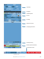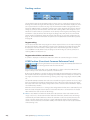
1
ARGUS RADAR
SYSTEM
User Manual
ENGLISH
Preface
Disclaimer
As Navico is continuously improving this product, we retain the right to make changes to the
product at any time which may not be reflected in this version of the manual. Please contact
your nearest distributor if you require any further assistance.
It is the owner’s sole responsibility to install and use the equipment in a manner that will not
cause accidents, personal injury or property damage. The user of this product is solely responsible for observing safe boating practices.
NAVICO HOLDING AS AND ITS SUBSIDIARIES, BRANCHES AND AFFILIATES DISCLAIM ALL LIABILITY FOR ANY USE OF THIS PRODUCT IN A WAY THAT MAY CAUSE ACCIDENTS, DAMAGE OR
THAT MAY VIOLATE THE LAW.
Governing Language: This statement, any instruction manuals, user guides and other information relating to the product (Documentation) may be translated to, or has been translated
from, another language (Translation). In the event of any conflict between any Translation of
the Documentation, the English language version of the Documentation will be the official
version of the Documentation.
This manual represents the product as at the time of printing. Navico Holding AS and its subsidiaries, branches and affiliates reserve the right to make changes to specifications without
notice.
Approvals and Warranty
Please refer to the website: http:pro.simrad-yachting.com
Record of changes
Part number/Rev.
Date
Purpose of change
Requested by
988-10185-001
September 2011
First issue
988-10185-002
October 2013
Software release 3.2
M. Carmagnini
988-10185-003
October 2014
Software release 3.2.5
M. Carmagnini
About this manual
This manual is a reference guide for operating the Argus radar system and describes the following software revision:
Software Edition SWC001A006
Release date:
January 2015
MAIN :
3.2.5
ATA
3.2.3
IOVP
3.2.5
Video Proc.
1.7 / 2.1
Graph. Acc.
1.6
Control Panel
16/30
The manual will continuously be updated to match new software releases. The latest available
manual version can be downloaded from the website:
http://pro.simrad-yachting.com
Preface | Argus Radar Operator Manual
|1
Safety precautions
The Argus radar is connected to 115 VAC or 220 VAC - 50 or 60 Hz power; therefore, before
starting any work on the equipment, make sure that the power supply is switched off.
The system is equipped with fuses protecting the electronics devices from short circuits,
which may damage the equipment or cause fire.
Depending upon the material to be highlighted, the following attention headings are used in
this manual:
Danger: Before turning on the radar, make sure that no one is standing near the antenna.
Warning: The electronics of the equipment are supplied with mains power, also when
the equipment is switched off. For this reason, opening a unit must be performed only by
skilled personnel.
Warning: An operating or maintenance procedure, practice, condition and statement
which, if not strictly observed, could result in injury to personnel or death.
Warning: An operating or maintenance procedure, practice, condition and statement
which, if not strictly observed, could result in damage to, or destruction of, the system or
reduced performance.
¼¼ Note: An essential operating or maintenance procedure, condition or statement, which must
be noticed.
Warning: Microwave radiation levels
Unit
configuration
TXRX/
Pedestal
Antenna
100 W/m2 Power
50 W/m2 Power dendensity distance (m) sity distance (m)
12 kW X-band +
6’ X-band antenna
Argus 12U
6 ft. X-band
12 kW X-band +
9’ X-band antenna
Argus 12U
9 ft X-band
0.5
12 kW X-band +
12’ X-band antenna
Argus 12U
12 ft. X-band
0.35
25 kW X-band +
6’ X-band antenna
Argus 25U
6 ft. X-band
25 kW X-band +
9’ X-band antenna
Argus 25U
25 kW X-band +
12’ X-band antenna
30 kW S-band +
12’ S-band antenna
0.15
0.1
10 W/m2 Power density distance (m)
0.6
0.2
1.3
9 ft X-band
0.1
1
Argus 25U
12 ft. X-band
0.05
0.9
Argus 30U
12 ft. S-band
0.9
When a precaution, which relates specifically to a part of this manual is required, the information is given in the relevant part of the manual.
Warnings and Cautions precede applicable text.
2|
Preface | Argus Radar Operator Manual
High voltage
Radar equipment includes high voltage that can cause injury or loss of life. Danger exists only
when the units are opened and exposing internal circuits, as when servicing the equipment.
The ARGUS Radar has been carefully designed to protect personnel from possible injury from
high voltages.
Nevertheless, it is recommended that the Main Power Line shall always be OFF, as an added
protection when inspecting or servicing the equipment.
Although every effort has been made to eliminate danger to personnel, no responsibility is
accepted for any injury or loss of life suffered in connection with this equipment.
Safety switch
The Radar Unit is provided with a safety switch, which disables the antenna rotation during
maintenance and avoids high voltage damage. Always turn the safety switch off, whenever
the procedure advises to do so (for instance, before performing any maintenance or installation procedure). Ignoring safety switch operation may produce hazard of electrocution as well
as other severe injures.
Safety precautions
Purpose
The described safety precautions are applicable to the ARGUS Radar System. Depending
upon the material to be highlighted, the following notes are used in this manual.
¼¼ Note: An essential operating or maintenance procedure, condition or statement which must
be highlighted.
Whenever a precaution, relating specifically to a part of this manual is needed, the information is given in the relevant part of the manual. Warnings and Cautions precede applicable
text.
Safety operations
Main power line is always present on terminal board and fuses. During normal operation
(front cover closed), the unit can quickly be disconnected from the main power line, setting
the relevant circuit breaker, located on the electric switchboard, to OFF.
Safety summary
The following are general safety precautions not related to any specific procedure and
therefore do not appear elsewhere in this manual. These are recommended precautions that
personnel must understand and apply during most phases of operation and maintenance.
KEEP AWAY FROM LIVE CIRCUIT
Operating personnel must at all times observe all safety regulations.
Do not replace components or make adjustments inside the unit with the high voltage supply turned ON. Under certain conditions, dangerous potentials may exist when the power
breaker is in OFF position, also due to charges retained by capacitors. To avoid casualties,
always remove power and discharge a circuit to ground before touching it.
DO NOT SERVICE OR ADJUST ALONE
Under no circumstances should any person initiate servicing or adjusting the unit without the
presence of someone capable of helping.
RESUSCITATION
Personnel working with or near high voltage should be familiar with modern methods of
resuscitation. Such information may be obtained from the Bureau of Medicine and Surgery.
Preface | Argus Radar Operator Manual
|3
Warning information
The following warnings will appear in the text of the technical manuals, and are repeated here
for emphasis.
Warning: Use extreme care when working on the unit once the cover has been
opened. The magnetron assembly operates at voltages that may prove fatal.
Warning: Beware of high voltage capacitors. It is necessary to short-circuit their
leads before performing any maintenance action on them.
Warning: On the electric switchboard, set the power breaker dedicated to the
present equipment to OFF and hang up a placard reading: “work in progress - do
not switch on”.
Warning: Set main line breaker to OFF before replacing a fuse. The voltage in
fuses are under the level which may prove fatal.
X-Ray radiation
X-ray radiation may be generated by Transceiver units and care must be taken to avoid possible harmful effects when they are opened for maintenance. When power is on, care should
be taken not to approach closer than 1 foot (12 cm) from the unit unless front cover is in
place.
Radio frequency radiation
Harmful effects (particularly to the eyes) may be caused by exposure of any part of the human
body to radio frequency mean power densities in excess of 100 mW/cm2. This power density
is exceeded at a distance of 1 foot (12 cm) or less, from the 12 ft. X-Band aerial (when stationary).
The system is however designed to disable radiation when the antenna is not rotating.
The pedestals have also been predisposed for the installation of an external safety switch,
which can be mounted on, or near the platform. This switch removes power from the
Pedestal eliminating the possibility of accidental operation during servicing and also causes
disabling of transmission.
Whenever it is necessary to disconnect the waveguide system from a radar transmitter for
maintenance purpose, the transmitter output should, when practicable, be terminated in
a matched load. If this is not possible, care should be taken to avoid standing in front of an
open-ended waveguide from which power is being radiated.
¼¼ Note: NEVER look down on a waveguide from which power is being radiated.
4|
Preface | Argus Radar Operator Manual
Contents
9
General information
9Introduction
10Abbreviations
12 How to read the system version
12 Available versions
13 Physical description
13 Monitor unit
13 Control panel (keyboard)
13 Core unit
13 General functioning description
14 Target and data display
14 Video signal processing
14 Failure procedure
14 Watchdog function
15 Technical characteristics
19 Basic operation
19 Keyboard controls and indicators
21 Procedure to switch on the system
22 Monitor presentation (4:3 system)
25 Monitor presentation (wide screen)
26 General operating procedures
26 GUI Widgets description
26Buttons
27Labels
27Shortcuts
27 Spin buttons
28 Switch buttons
28 List boxes
28 Combo boxes
28 Check buttons
28 Progress bars
29 The three function keys on the keyboard
32 Focusing function
32 Clicking in the ARGUS interface
32 Cursor shape
33 Menu window
33 Numeric and alphanumeric keyboards
34 The button’s label
34 Small menu-like icon
34 Tool icon
34 List of symbols
35 Own ship section
35 Gyro and speed
35 Gyro preset
36Speed
38 Speed source selection
38 Log speed
38 Manual speed
38 Auto drift speed
39 EPFS speed
40Course
40 Own ship geographic position
40 UTC or local time
40 Map name
41 Help line section
41 Operating mode section
41 Cursor section
41Cursor
41 Latitude and Longitude or ETA and TTG
42 Tracking section
Contents | Argus Radar System Operator Manual
|5
42 Target tracking
42 Target track and AIS association mode
42 CCRP Position (Consistent Common Reference Point)
43 Parallel index menu
43 Main menu
43 Radar configuration
44 Personal settings
46 Video level equalization
49Layout
50 Brilliance settings
50 Day color
50 Antares PCB info
51Sharing
51 About Argus
52 ECDIS interface functions
54 Conning menu
56 Task window movement
57 Picture in picture
58 Additional PPI
60 Radar presentation and video processing
60 Presentation and visualization options section
60 Orientation and motion modes
60 Head Up
61 North Up
61 Course Up
61 Relative motion (RM)
61 True motion (TM)
61 P reset/TM reset
62 The row under PPI area
62 Range scale increase/decrease
62 Range rings on/off
62 PPI Centre/Off centre
63 P reset/TM reset
63 Gnd Stab/Sea Stab
63 Heading line and PPI graphics on/off
63Tune
64 Video processing section
64Gain
65Rain
66Sea
68 Video preset
68 Interference rejection
69 Scan to Scan correlation
70 Mutual radar interference
70 Second trace echo
70 Sweep to Sweep correlation
70 Target enhancement
70 SART video presentation
73 RACON (Radar Beacon) video presentation
73 Racon technical characteristics
74 Video processing menu
75 Which preset is the right one?
76 TXRX interswitch menu (standard)
76Master/Slave
76 Performance monitor on/off
77 Power normal/boost
78 TXRX data
78 Standard speed
78 TXRX interswitch menu (Configuration video combination)
79 Tracking and video processing operation in combination and 2nd PPI mode
80 A or B combination
80 A and B combination
81 Sector combination
6|
Contents | Argus Radar System Operator Manual
82
A and / or B combination
83Measurement
83 Radar echo measurement
83 Measurement by means of range rings and bearing scale
83 Measurement by means of the cursor
83 Measurement by means of the ERBL 1 or 2
84 More target data measurement
85 Cursor section
85Cursor
85 Latitude and Longitude or ETA and TTG
85 ERBL 1 and 2
86 Parallel indexes
88 Range rings
89Tracking
89 General information
89 Radar target tracking facility
90 Tracking operation in 2nd PPI zone and under video combination mode
90 AIS (Automatic Identification System)
93 Tracking target symbols
96 Target overload
97 Radar target trails
97 Past positions
98 Vector time
98 True/Relative vector
98 Tracking menu
99 Anchor watch
99 Training target
100 Cancel ALL TGT
100 Minimum safety menu
100 Auto-Acquisition zone
100 Guard zones/Auto Acquisition zones
102 Trial manoeuvre
102 Manual trial manoeuvre
103 Automatic trial manoeuvre
106 AIS and radar target association
107 AIS On/Off
107 AIS list
108 TT target list
108 AIS limit priority
108 AIS filtering
109 AIS options
109Symbol
109 TT, AIS and navigation symbols
110 Route presentation and waypoint data
111Predictor
111 Displaying target information
116Maps
116 General information
117 Create a new map
120 Operating with a selected video map
120 Editing objects on the video map
122 Geographic map manual settings menu
123 Selection and movement with the trackball cursor
124 Selection and movement by means of the editable labels and buttons
125 Import and export of a map
126
126
127
128
Alarm and system failures
System status
Alarm list
Audio On/Off
Contents | Argus Radar System Operator Manual
|7
128
129
130
131
131
132
Radar presentation failure
List of system failures
List of alarm messages
List of wrong operation messages
List of warnings operation messages
List of operating modes fallback
134Maintenance
135 ARGUS FMCW radar
135General
136 Additional benefits of FMCW radar
137 FMCW radar scanner specifications
138 Overall dimension of FMCW radar
138 FMCW transceiver radar system installation and settings
138 Preliminary operations
138 First time installation
138 Activating the FMCW transceiver radar system
140 FMCW device configuration menu
141 Utilization of the FMCW transceiver radar system
141 Selection of the FMCW transceiver on additional PPI
142 Description of commands relative to the window of the FMCW radar transceivers
144Limits
8|
Contents | Argus Radar System Operator Manual
1
General information
Introduction
•
•
•
•
•
•
•
•
•
•
The ARGUS Radar is a radar indicator with a presentation based on a raster scan principle.
The advantages of using the raster scan principles to produce a radar display are as follows:
true daylight presentation
continuous display of radar video
high number of graphics that can be superimposed to the radar picture
areas where all necessary navigational data can be presented at the same time.
The radar scans the horizon over a total of 360°, azimuth samples are converted and stored in
a memory, and then presented on a raster scan display. These conversion and memory logics
make the core (heart) of the indicator.
In order to have a display resolution similar or better as compared to a traditional radar
picture, very large memories are used. In addition, the display monitor is able to present
video data without loosing even the smallest information written into the memory. However,
various monitors with different resolutions can be connected to the ARGUS Radar System, so
depending on the choice of monitor, the graphic interface can be quite different from one
monitor to the next. The graphic layouts and widgets in this manual are examples only and
may therefore not appear exactly the same on the screen in your system.
In order to reduce the number of circuit boards (PCBs), a CPU performs multiple functions.
Therefore, the CPU has the total control of the system and gives the advantage to have very
sophisticated diagnostics and great flexibility.
Very large scale integrated micrologics are used.
A single card forms a complete sub-function and has very few connections to the rest of the
system.
The modular design in the base of the system and sub-units are easily replaced in case of
malfunction.
The ARGUS Radar performs the following operations:
it receives the ship sensor’s data, which are:
GYRO - indicates the ship heading
LOG - indicates the ship speed
EPFS - indicates the ship position, speed and course
AIS - identifies the ships in the area
it interfaces and receives signals from up to four transceivers (scanners), with relevant antenna,
and allows the operator to select the transceiver to be used for the presentation
it processes the received signal in order to detect targets
it processes the signal relevant to a target in order to obtain the target data: position, speed,
course, heading
it automatically tracks a target in order to update the target data
it shows the target position on the monitor.
General information | Argus Radar System Operator Manual
|9
Abbreviations
Navigation related information is very often presented using the standard terms or abbreviations. In the following table you will find the most common abbreviations and the ones used
in this manual.
Abbreviations
Terminology
Abbreviations
Terminology
ACK
Acknowledge
ECDIS
Electronic Chart Display And Information
System
ACQ
Acquire
ADJ
Adjust
ECS
Electronic Chart System
AIS
Automatic Identification System
EGNOS
ALARM
Alarm
European Geo-Stationary Navigational Overlay
System
ANCH
Anchor Watch
ENCSOG
Automatic Navigational Chart
ANT
Antenna
EP
Estimated Position
AP
Autopilot
EPFS
Electronic Position Fixing System
ARPA
Automatic Radar Plotting Aid
EPIRB
Emergency Position Indicating Radio Beacon
AUD
Audible
EQUIP
Equipment
AVAIL
Available
ERBL
Automatic Range And Bearing Line
AZ
Acquisition Zone
ETA
Estimated Time Of Arrival
AZI
Azimuth Indicator
ETD
Estimated Time Of Departure
BCR
Bow Crossing Range
EZ
Exclusion Zone
BCT
Bow Crossing Time
FK
User Function Key
BKGND
Background
FMCW
Frequency Modulated Continuous Wave
BRG
Bearing
FWD
Forward
BRILL
Display Brilliance
GAS
Grounding Avoidance System
BWW
Bearing Waypoint To Waypoint
GEOG
Geographic
C UP
Course Up
GLONASS
Global Orbiting Navigation Satellite System
CCRP
Conistence Common Reference Point
GMDSS
Global Maritime Distress And Safety System
CENT
Centre
GND TRK
Ground Track
CNCL
Cancel
GNDSTAB
Ground Stabilised
COG
Course Over Ground
GNSS
Global Navigation Satellite System
CONT
Contrast
GPS
Global Positioning System
CPA
Closest Point Of Approach
GYRO
Gyro
CPU
Central Processing Unit
GZ
Guard Zone
CRS
Course
H UP
Head Up
CTS
Course To Steer
HDG
Heading
CURS
Cursor
HL
Heading Line
DAY/NT
Day/Night
HR
Hours
DECR
Decrease
I/O
Input/Output
DEG
Degrees
IBS
Integrated Bridge System
DEL
Delete
ID
Identification
DGPS
Differential Gps
IN
Input
DISP
Display
INIT
Initialisation
DIST
Distance
INS
Integrated Navigation System
DPTH
Depth
IR
Interference Rejector
DR
Dead Reckoning
IRCS
Integrated Radio Communication System
DSC
Digital Selective Calling
ISW
Interswitch
DW
Deep Water
Km
Kilometre
EBL
Electronic Bearing Line
KN
Knots
10 |
General information | Argus Radar System Operator Manual
Abbreviations
Terminology
Abbreviations
Terminology
LBL
Label
RNG
Range
LIM
Limit
ROT
Rate Of Turn
LOST TGT
Lost Target
RR
Range Rings
LP
Long Pulse
RTE
Route
m
Metres
RX
Receiver
MAP
Maps
SAF CON
Safety Contour
MIN
Minimum
SAR
Search And Rescue
MIN
Minutes
SC/SC
Scan To Scan
MKR
Marker
SDME
Speed and Distance Measuring Equipment
MOB
Man Overboard
SEL
Select
MP
Medium Pulse
SENC
System Electronic Navigational Chart
MSTR
Master
SK
Soft Key (each button of the trackball)
N UP
North Up
SNR
Signal To Noise Ratio
NAV
Navigation
SOG
Speed Over The Ground
NC
Normally Closed
SP
Short Pulse
NLT
Not Less Than
SPD
Speed
NM
Nautical Mile
SRNC
System Raster Navigational
NMT
Not More Than
STAB
Stabilised
NUC
Not Under Command
STBD
Starboard
OFF CENT
Off Centre
STBY
Standby
OFFTRK
Off Track
STW
Speed Through The Water
OS
Own Ship
T BRG
True Bearing
OUT
Output
T CRS
True Course
PAD
Predicted Area Of Danger
T SPD
True Speed
T VECT
True Vector
PAST
POSN
Past Positions
TCPA
Time To Closest Point Of Approach
PCB
Printed Circuit Board
TGT
Target
PI
Parallel Index Line
TM
True Motion
PL
Pulse Length
TPR
Transponder
PM
Performance Monitor
TRIAL
Trial Manoeuvre
POSN
Position
TRIG
Trigger Pulse
PPC
Predicted Point Of Collision
TRK
Track
PRF
Pulse Repetition Frequency
TRKG
Tracking
PWR
Power
TTG
Time To Go
R BRG
Relative Bearing
TWOL
Time To Wheel Over Line
R CRS
Relative Course
TX
Transmit
R VECT
Relative Vector
TX
Transmitter
RAD
Radius
TX/RX
Transceiver
RCDS
Raster Chart Display System
UPS
Uninterruptible Power Supply
REF
Echo Reference
VRM
Variable Range Marker
REF SOG
Echo Reference Speed
VTS
Vessel Traffic Services
REL or R
Relative
WOL
Wheel Over Line
RM
Relative Motion
WOP
Wheel Over Point
RM (R)
Relative Motion (Relative Trails)
RM (T)
Relative Motion (True Trails)
RNC
Raster Navigational Chart
General information | Argus Radar System Operator Manual
| 11
How to read the system version
The function of the System Version menu is to recognise the program and the version running within the system.
To display the System Version:
1. Open the menu by pressing the relevant button
2. Press the About Argus button.
This menu summarises all the programs running within the system.
Available versions
ARGUS P 180 WS
>180 mm
Trial
manoeuvres
Predictor
Network
sharing
ECDIS interface
•
•
Activated AIS
targets
•
Total AIS targets
ARGUS P 25O WS >250 mm
•
Tracked radar
targets
>250 mm
•
FMCW Radar on
additional PPI
>320 mm
ARGUS P 250
•
•
•
•
Additional PPI
Zoom
ARGUS P 340
•
•
•
•
Menu at both
sides
Video
Combination
>320 mm
WIDE PPI
Actual radar
picture
ARGUS P 340 WS
Simplified
Conning
Argus models
The system can be configured with different additional functions, according to the monitor
being used:
•
•
100
300
110
•
•
•
•
•
•
•
•
•
•
•
•
•
•
•
•
•
•
100
300
110
100
300
110
100
300
110
20
120
20
To better understand the different functions, see the following paragraphs:
Actual radar picture: See “PPI Centre/Off centre” on page 62.
Video Combination: See “A or B combination” on page 80.
Zoom: See “Zoom” on page 59.
Simplified Conning information: See “Conning menu” on page 54.
WIDE PPI: See “Monitor presentation (wide screen)” on page 25.
Menu at both sides: See “Layout” on page 49.
Additional PPI: See “Additional PPI” on page 58.
FMCW interface: See “Selection of the FMCW transceiver on additional PPI” on page 141.
Tracked radar targets: See “AIS and radar target association” on page 106.
Total AIS targets: See “AIS filtering” on page 108.
Activated AIS targets: See “Target overload” on page 96.
Trial manoeuvres: See under “Technical characteristics” on page 15.
12 |
General information | Argus Radar System Operator Manual
Predictor: See “Predictor” on page 111.
Network sharing: See “Sharing” on page 51.
ECDIS interface: See “ECDIS interface functions” on page 52.
Physical description
•
•
•
•
The ARGUS Radar System consists of the following units:
Monitor Unit on which the data, command buttons inside the SYSTEM DATA AREA, and the
echoes with relevant targets inside the PPI AREA are displayed.
Core Unit in which the ARGUS electronic boards are mounted.
Keyboard Unit on which the hardware of the Control Panel is mounted.
Scanner Unit – not included. Refer to Simrad ARGUS Radar Scanner – Technical Manual.
Monitor unit
The Argus Monitor Unit represents the visual interface between the Operator and the Equipment. The equipment can be supplied with different types of Monitor Unit. Technical characteristics are located in the next paragraph.
Control panel (keyboard)
The Control Panel is the interface on which the operator can insert data, change the working
parameters and perform the operations necessary for the correct use of the equipment.
The Control Panel features light indicators, pushbuttons, rotating knobs and a trackball, which
controls the equipment. For more details, refer to Chapter 2.
The Control Panel is connected to the Core Unit by means of a cable with connector.
Core unit
•
•
•
•
•
•
The Core Unit consists of the following main parts protected in a dedicated cabinet::
the Antares Assy
the Alpha Board
the optional Alpha Expansion Board
the Power Supply mounted on the Alpha Board
the Line Filter
the Main Power Switch
For details, refer to Simrad ARGUS Radar Installation & Service manual.
The boards are made up of multi-layers printed circuits using VLSI components; programmable gate arrays and microprocessors are used to achieve a high package density, functional
reliability and low power consumption.
Auxiliary indicators (Light Emitting Diodes) are also located on the boards to allow easy
scheduled test, troubleshooting and maintenance actions.
The Line Filter is fixed to the left lateral panel of the Core Unit by means of nuts. The supply
voltage (115 VAC – 220 VAC 50/60 Hz) is applied through the Main Power Switch to the Alpha
Board.
The Alpha Board is fixed on the left side of the Core Unit by means of screws. The board is
the interface between the Argus monitor, auxiliary navigation equipment (GYRO, GPS, LOG,
AIS…) and the TXRXs (transceivers) connected. The interconnection allows commands to be
transmitted or received through BNC connectors and the Terminal connectors.
General functioning description
•
•
•
•
•
The Argus monitor receives the following signals from the connected transceiver(s):
Video Signal
Trigger
Azimuth (AZ)
Heading Line (HL)
TXRX Data
General information | Argus Radar System Operator Manual
| 13
The data is applied to the TXRX interface block of the Alpha Board that, upon command from
the Main Processor on the Antares Board, selects the transceiver to be used. The signals from
the selected transceiver represent the data on which the equipment operates.
The signal process mainly consists of two steps:
• the Video Signal Processing
• the Automatic Target Tracking.
The results of the signal processing are both visualised on the monitor and sent to the Automatic Target Tracking circuits.
Target and data display
The monitor presentation area is subdivided in a radar video presentation called PPI AREA
and a data table SYSTEM DATA AREA (for more details, refer to Chapter 2). The total area of
the screen is made up of a rectangle of pixels, depending on the size of the display. The video
signal and the graphic symbols (vectors, arcs, special symbols, bearing scale and segments)
are represented within the area of the PPI.
Video signal processing
This section receives the Video Signal from the transceiver and, after conversion into digital
form, processes it by removing:
• Sea Clutter
• Rain Clutter
• Interference.
The processed signal is sent to:
• the monitor for visualisation
• the Automatic Target Tracking circuits.
In the Video Signal Processing blocks, the digital signal is processed by means of complex
algorithms in order to recognise the presence of a target and, if the target is present, its shape
and the target coordinates.
The target coordinates and the target shape are sent, in digital form, to the Automatic Tracking Section of the equipment.
Failure procedure
This description does not describe failures that can occur during operation. If a failure occurs,
the operator must perform all relevant actions in order to remove the failure itself. When a
failure occurs, the fail condition is pointed out by:
• the red SYSTEM FAIL LED
• the acoustic alarm
• the Fail System Warning will be displayed in the General Purpose Section.
Watchdog function
Warning: The equipment’s operational software is monitorised by a hardware watchdog with a 3s timeout.
Non recoverable errors due to hardware faults are indicated by FAIL indication on the Control
Panel flashing at approximately 1 Hz.
Any type of failure caused by software or hardware, which stops the system for more than half
a second activates the System Failure relay on the Alpha PCB. This check doesn’t need software intervention, but is automatically controlled by the hardware. The Failure relay contact
is normally closed, so the function is active, also when the main line is absent or the power
supply has failed.
14 |
General information | Argus Radar System Operator Manual
Technical characteristics
1
General description
The ARGUS Radar fully complies and exceeds IMO recommendations.
The ARGUS Radar is composed of the scanner unit and three modules i.e. a desk-mounted Monitor Cabinet, Keyboard and
Core Unit. Thanks to the modular design, it can be assembled to form a stand-alone display cabinet or may be flushmounted into a mechanical bridge console. The standard basic configuration always includes an electronic, built-in Interswitch for
dual radar installation.
The above flexibility makes the ARGUS Radar the optimum solution for a dual radar system on new constructions and retrofit installations.
2
Display unit
Actual radar picture Resolution
(mm)
(pixels)
Suggested viewing
distance (m)
Category of ship/
craft
Monitor size: 16/19” WS
> 180 mm
1366 x 768
1
CAT3
Monitor size: 24” WS
> 250 mm
1920 x 1080
1
CAT2/CAT2H
Monitor size: 19”
> 250 mm
1280 x 1024
1
CAT2/CAT2H
Monitor size: 23”
> 320 mm
1600 x 1200
1
CAT1/CAT1H
Monitor size: 26/27” WS
> 320 mm
1920 x 1200
1
CAT1/CAT1H
Performance for categories of ship/craft for Solas V
Description
CAT3
Minimum operational display area
CAT2
CAT1
180 mm
250 mm
320 mm
195 x 195 mm
270 x 270 mm
340 x 340 mm
Auto Acquisition of Targets
YES
YES
YES
Acquired Radar Targets Capacity
20
100
100
Active AIS Targets Capacity
20
110
110
Sleeping AIS Targets Capacity
120
300
300
Trial Manoeuvre
YES
YES
YES
Minimum Display Area
3
Technical specifications
Video processing
• Digital processing on: 8 bit (256 levels)
• Manual /Automatic Sea anti-clutter and rain anti-clutter
• Sweep to sweep (Interference Rejection), scan to scan video correlation for residual sea
clutter removal, target enhancement
• Scan to scan correlation for echo trails. True and relative trails calculated simultaneously in every presentation mode
• Trails are maintained between changes in range scale and PPI position
Presentation modes
Day/night modes
- Relative motion (RM)
Head up, Course up and North up
- True motion (TM)
Course up and North up
Off-centering
Up to 50 % of range scale in use
Range scales
0.125, 0.25, 0.5, 0.75, 1.5, 3, 6, 12, 24, 48, 96
Range rings
0.025, 0.05, 0.1, 0.25, 0.75, 0.5, 1, 2, 4, 8, 16
Range resolution
3 m on 0.75 NM range scale
VRM
Dual VRM from 0 to 96 NM with digital readout
VRM resolution
0.01 NM
VRM accuracy
1% of range scale in use
Azimuth resolution
0.1°
EBL
Dual EBL with independent 0-360° true or relative digital readout
EBL resolution
0.1°
General information | Argus Radar System Operator Manual
| 15
3
Technical specifications
Trackball
Polar and Geographic coordinates continuously displayed
Diagnostics
On-line diagnostic built-in
Radar target facilities:
Acquisition
Manual or automatic up to 100 or 20 targets (depending on the category), up to 24 NM
Tracking
Automatic up to 100 or 20 targets (depending on the category), up to 24 NM
Auto acquisition/
Guard Zones
One auto acquisition zone stabilized on Ownship heading and size/shape configurable.
Four sectors with fixed width of 0.5 NM configurable as auto acquisition or guard zone
AIS facilities:
Presentation
Up to 300 or 120 targets (depending on the category), in sleeping accepted with selectable
priority (nearest range, most dangerous). Presentation filters according to AIS class, range,
CPA, TCPA, speed
Acquisition
Manual or automatic activation of up to 100 targets CAT1/2 or 20 targets CAT3 plus manual
selection through a table ordered in ship name and distance
Safe Checking
All AIS targets in sleeping or activated state
Auto acquisition/
Guard Zones
Same zones described in Radar Target facilities
Trial manoeuvres:
Trial course
For ARPA and AIS targets. Manually adjustable from 0° to 360° or automatically computed
within 135° with reference to the present course
Trial speed
Adjustable from 0° to 50 Knots
Trial ROT
Adjustable from 1° to 60°/min.
Trial time
Adjustable with 1 minute increments
Mapping:
Operator compiled maps up to 120 segments plus symbols and text strings with selectable
colors and line styles
Map Stabilization
Relative, True (Dead Reckoning) or geographic
Map storage
By Name, on a built-in non volatile memory. Transferable via USB Memory stick
Map adjustment
Position and orientation
Graphic functions:
True or relative time adjustable vectors
Target identification number, trackball marker and true marks. AIS identification number,
ship names or call signs
Time adjustable past position plots
Four independent parallel index lines
Waypoints and Route from EPFS
Ownship shape and activated AIS target shape on lower range scales
Additional features:
Zoom
Enlarges a selected area over the main PPI
Picture in Picture (CCTV)
Opens a window inside which is an area of the ship for monitoring; e.g. the hold or car deck
of a ship. (Number of video input channels according to monitor specifications)
Simplified conning infor- Graphic display of sensors, e.g.:
mation
• Wind sensor
• Steering Gear
• Heading sensor
• CCTV Input
• Echo sounder
• SDME sensor
16 |
Additional PPI
Additional PPI with the same functions as the main PPI, including the possibility to interact
with different TXRXs at the same time
ECDIS interface
Function for complete integration with an ECDIS system connected via LAN
General information | Argus Radar System Operator Manual
3
Technical specifications
Video Combination
Possibility to select two radar sources and the possibility to view the two sources at the
same time in a single image. The automatic Tracking uses the two sources to track targets,
even across the blind sectors of the radar antennas
Data readout:
ARPA Target data
Range/bearing, speed/course, CPA/TCPA and Latitude/Longitude
AIS Target data
Ship Name, MMSI, Call Sign, Range/bearing, speed/course, CPA/TCPA and Latitude/Longitude, Type, Status, Destination, ETA, ship size, AIS class
Ownship data
Heading, Speed/Course water or ground stabilized Geographic position and UTC time
System setting:
Safe Minimum CPA & TCPA, vector/past positions / trial / trials time
Alarms:
Acoustic and visual warning for: Dangerous Target, Target in Guard Zone, Lost Target, System Failure and external interface sensors (EPFS and AIS)
Other features:
Anchor-watch, echo reference speed (not for AIS enabled systems), EPFS speed
Built-in, electronic dual interswitch facility plus additional expansion, up to four transceivers.
Coaxial cable only connection (SXI mode) to TXRX
Inputs:
Gyro Heading
Analog: synchro or stepper. Digital Fast NMEA (IEC 61162-2)
Speed Log
Analog: PIT or two axis log. Digital: NMEA (IEC 61162-1)
EPFS
Serial Interface NMEA (IEC 61162-1)
AIS
Serial Interface NMEA (IEC 61162-1)
External Alarm Interface
Serial Interface NMEA (IEC 61162-1) – RAACK sentence
Outputs:
Serial Interface NMEA 0183 (IEC 61162-1)
RATTM - RAOSD – RARSD – RAALR – RATLB – RATTD sentences
Dead Man Alarm, Power Fail, Danger Target relay outputs configurable as NC or NO
Other interfaces:
Double Ethernet port 10/100 with a full set of TCP/IP protocols. System redundancy for LAN
connection failure
Four USB 2.0 port
Environmental features:
Operating temperature
-15°C / 55°C (IEC 60945 protected equipment)
Storage temperature
-25°C / 70°C (IEC 60945 protected equipment)
Relative humidity
Up to 95% at 40° (IEC 60945 protected equipment)
Water proofness
IP66
Vibrations
As per IEC60945
Power consumption:
500 W max (depending of monitor and wind load on TXRX)
Power Supply:
220/115 VAC 50/60 Hz
Dimensions:
Core unit only: Width 46 cm, height 35 cm, depth 15 cm
Weight:
Keyboard
2 kg
Core unit:
9 kg
Type approval:
IEC 60945 (General Requirements)
IEC 62388 (Radar Performance)
IEC 61162-1/2 (NMEA interface)
General information | Argus Radar System Operator Manual
| 17
Warning: Highest mast position is good for long range detection, but it heavily affects
the detection in sea clutter. For optimal detection in sea clutter, suggested antenna height
from sea level is around 20 m. Usually the contradictory specifications are solved with
installation of more than one antenna, e.g. one at 30 m for long range detection and one
at 20 m for optimal detection of low intensity echoes in sea clutter. THe S-band transceiver
is always the optimal choice for reducing rain clutter reflections and increase long range
detection. Longer antennas for X-band are less susceptible to rain and sea clutter.
Warning: According to IMO standard, a ground speed sensor is required to be connected to the Argus console. Only electronic positioning systems (EPFS) approved in accordance whit the requirement of the IMO in resolution msc.112(73) shall be connected to
the radar console.
It is allowed to use an electronic position fixing system (EPFS) approved in accordance with
the requirements of the IMO in resolution msc.112(73) or an alternative two dimensional
ground stabilising SDME in compliance with IMO resolution msc.96(72).
Warning: Only electronic positioning systems (EPFS) approved in accordance with the
requirements of the IMO in resolution msc.112(73) shall be connected to the radar console.
Warning: The radar unit is provided with a safety switch, which disable the antenna
movement during maintenance operations and avoids high voltage damage. Always turn
the safety switch off, whenever advised in this manual (for instance, before performing any
maintenance or installation procedures). Ignoring safety switch operation may produce
hazard of electrocution as well as other severe injures.
18 |
General information | Argus Radar System Operator Manual
2
Basic operation
Keyboard controls and indicators
5
1
POWER
2
TX ON
7
8 12 9
BRILL
SYSTEM
CHART
RADAR
CONN
OTHER
MOB
EVENT
SHOW
LAYER
AUDIO
GAIN
10 14 11
SEA
RAIN
DISPLAY
3
FAIL
FNCT 1
FNCT 2
FNCT 3
TM /
RM
COURSE
UP
OFF
CENTRE
CENTRE
4
HEAD
UP
15
TUNE
TRACKING
NORTH
UP
PRES
RESET
ACQ
SEL
CANCEL
RANGE
VRM
EBL
6
Ref.
Control or
indicator
13
6
Description and function
1
POWER
This pushbutton with green LED indicator is used to switch between
Sleep and On conditions. When the system is in Sleep condition it
appears to be Off, but the electronic is still on, waiting for the real On
condition request. In order to switch on the monitor, and the control
panel, the operator has to press the POWER button, and holding it
pressed for more than 5 seconds. An audible beep will sound and the
green LED next to the pushbutton will change to high brilliance.
In “On” condition, by pressing the POWER button again, the monitor,
and the control panel will be switched off again and another beep
will sound and the green LED will return to low brilliance, bringing the
system into a Sleep mode (to shut down the system completely, the
main power switch of the core unit must be set to position 0).
2
TX ON
This pushbutton is used to switch the system between Standby and
TX ON. In Standby the display does not request the TXRX to transmit,
but it is possible to get some information from the system, depending
on the type of TXRX connected. In TX ON the radar (if Master) radiates and the antenna turns. This is the normal working condition (the
switching “Standby to TX ON” and “TX ON to Standby” are executed at
the release of the pushbutton).
3
FAIL
This indicator is normally Off. A red-colored LED will be switched on
when a system failure occurs (this is an indicator, not a button).
4
USB port
USB type 2.0. Main purpose is to simplify file sharing and software
upgrading.
5
SYSTEM
user
functions
Momentary pushbuttons used to access the function or to execute
one of the three programmable functions (FNCT 1, 2, 3) as described
in “The three function keys on the keyboard” on page 29.
6
EBL/VRM
Use the rotary knob to set the EBL/VRM 1 or 2 alternatively. The EBL/
VRM data are displayed in the related windows. For further details,
refer to “Measurement by means of the ERBL 1 or 2” on page 83.
7
BRILL
Monitor and keyboard dimmer. Push to toggle Day/Night.
8
GAIN
GAIN control. Push to toggle Manual/Auto modes. The optimum setting is when the receiver background noise is hardly visible. For further
details, refer to “Gain” on page 64.
Basic operation | Argus Radar Operator Manual
| 19
Ref.
Control or
indicator
Description and function
9
SEA
Anti-Sea Clutter by reducing the gain at minimum range gradually
returning to normal. Push to toggle Manual/Auto modes. The gain
varies with the distance according to a predetermined curve and in an
amount proportional to the setting. When the potentiometer is turned
fully counter clockwise, the gain is uniform over the entire screen.
10
RAIN
Anti-Rain Clutter. Push to toggle Manual/Auto modes.
Large target masses will show only the immediate shoreline, thus,
permitting prominent targets on land to appear. Rain or snow clutter
can be reduced by the use of the potentiometer, and covered target
revealed. For more details, refer to “Rain” on page 65.
11
TUNE
Push for 2 seconds to toggle between Manual/Auto modes. If manual,
keep it pressed to change the tuning. The tuning may be checked by
means of the numeric indicator on the screen, or directly by observing
a target echo. In the last case, the echo level should be slightly above
the noise level (not saturated). The tuning meter indication is displayed
on long pulse only. For more details, refer to “Tune” on page 63.
12
DISPLAY:
TM/RM
Toggles True Motion and Relative Motion modes.
COURSE UP
Momentary pushbutton used to select a stabilised Course Up presentation. Press again in Course Up mode to enter a new course reference.
HEAD UP
Momentary pushbutton used to select Head Up presentation (referred
to Heading Line).
NORTH UP
Momentary pushbutton used to select North Up presentation
(referred to Gyro North). When the PPI is in True Motion mode the
presentation is automatically selected. For more details, refer to “North
Up” on page 61.
PRESS RESET Momentary pushbutton used to reset the position of own ship 180°
against the course.
OFF CENTRE Momentary pushbutton used to set the off-centered presentation
on the point under the cursor of the trackball (if the cursor is placed
inside the PPI).
For more details, refer to “PPI Centre/Off centre” on page 62.
CENTRE
Momentary pushbutton used to set the PPI centered presentation.
Not active in True Motion presentation.
13
RANGE
Two momentary pushbuttons used to select one of the 10 different
range scales, expressed in NM, and the relevant range rings for PPI
presentation.
With the + pushbutton it is possible to increase the range scale while
with the - pushbutton it is possible to decrease it. For further information refer to “Range scale increase/decrease” on page 62.
14
TRACKING:
15
20 |
ACQ(UIRE)
Momentary pushbutton used to acquire a radar target or to activate
an AIS target.
SEL(ECT)
Momentary pushbutton used to display alphanumeric information
related to the selected radar target or AIS.
CANCEL
Momentary pushbutton used to delete a tracked radar target or to
deactivate an AIS target.
TRACKBALL
Positioning input device. Use the trackball to move the cursor on the
PPI (displayed as a cross) and on the system data area (Menus area,
displayed as a black arrow, except for the progress bars in which it is
possible to change the value, where it’s displayed as a double horizontal thin arrow).
Basic operation | Argus Radar Operator Manual
Procedure to switch on the system
Switching on the main power switch placed on the core unit, the system will boot and the
Standby window will appear. Pushing the POWER button the system will switch between
Standby and Sleep mode. When the system is in Sleep mode it appears to be powered off,
but the electronics are still on, waiting for the actual Power On mode request. In order to
switch on the monitor and the keyboard, the operator has to press the POWER button, and
holding it for more than 3 seconds. An audible beep will sound and the green LED next to the
pushbutton will change to high brilliance.
In Power On mode, by pressing this pushbutton again (for more than 3 seconds), the monitor and the keyboard are switched off again, another beep will sound and the green LED will
change back to low brilliance; the system is now in Sleep mode (to shut down the system
completely you need to switch off the main power switch of the core unit.
•
•
•
•
After switching on the system, the Standby window will be shown on the monitor and the
brilliance is automatically set to the lowest level in night colors. This feature is important in
case of switching on during the night to avoid a strong flash into the eyes of the operator. For
daylight operation, click on the centre mouse key or press the BRILL button to obtain the day
highlighted colors palette. The Standby window below provides informative data, such as:
TXRX Status (Standby, Short, Medium or Long Pulse, warm-up countdown, etc.)
Possible selection of Transceivers (with only one connected, no selection is possible)
Operation mode at the next TX ON (master or slave)
Magnetron and System Life Times (available only for TXRX version 54 or higher).
When the system is in Standby (Standby window visible in the centre of the screen and TX ON
yellow LED off ) the operator is allowed to switch on the RF transmission, using the TX ON button. In Standby the radar display does not require the TXRX to transmit, but the transmission
could be on due to the control by another display or the TXRX could also be in Local mode
in transmission (for more details regarding the Local/Remote mode refer to the transceiver
technical manual). In TX ON mode, the radar antenna (if Master) radiates and turns. This is the
normal working condition (Standby to TX ON and TX ON to Standby switching are executed
at the release of the pushbutton).
Warning: In TX ON condition, pressing the TX ON button the system will return to
Standby.
Basic operation | Argus Radar Operator Manual
| 21
Monitor presentation (4:3 system)
The monitor function is to visualise all necessary information to carry out the scheduled navigation and show information related to targets, own ship, settings and measurements, etc.
According to the procedure described in the previous paragraph, clicking the TX ON button
will turn on the yellow LED and set the scanner in transmit mode. When transmitting, the following window will be displayed on the screen.
Monitor Display - General view
The window displayed can be divided into the following two main areas:
• PPI area in which the radar video is displayed. In this area all the tracking and navigation operations can be performed.
• SYSTEM DATA area, which features all the menus for the operator to control the system, to set
all the data required by the system and to perform all the radar target /AIS operations. The
SYSTEM data area is organised in the following 9 sections - see next page.
22 |
Basic operation | Argus Radar Operator Manual
1) Own ship
2) Help line
3) Operating mode
4) Cursor
5) Tracking
6) Main menu control
7) Displaying information
8) Video processing
9) Alarms/System status/Failure
10) Presentation modes
System data area sections
Basic operation | Argus Radar Operator Manual
| 23
System data area
Ref. Sections
Function
1
Own ship
In this section all parameters regarding own ship are indicated:
• AIS operating mode (ON/OFF, if connected)
• Heading
• Speed and course
• Own ship geographic position
• UTC or Local time
• Map name (if displayed)
• Number of tracked targets or AIS with target overflow identification
• AIS input priority, display filtering, source data during target association.
2
Help line
This line with three columns indicate the various options for each mouse button according to
the operating mode (Tracked target, PPI, Map editing).
3
Operating mode
Selecting one of the two modes, the operator can select operating in Tracked target or PPI
mode. Changing the operating mode, will consequently change the suggestions in the help
line and the functions of the three function buttons on the keyboard.
4
Cursor
In this section all parameters regarding the cursor are displayed i.e. Cross cursor in:
• Range and bearing, true or relative
• Geographic position.
5
Tracking
In this section all parameters regarding AIS and targets are shown:
• Number of tracked targets or AIS with target overflow identification
• AIS input priority, Display filtering, Source data during target association.
6
Main menu control
By pressing the main menu, a dropdown menu with submenus will be displayed. Refer to
“Main menu” on page 43 for the explanation of these submenus.
7
Displaying
information
In this section (normally empty), the information, data and measurements according to the
operator actions e.g. the menu and the target data are displayed.
8
Video processing
This section includes the signal processing menu. The signal processing menu includes: GAIN,
RAIN, SEA, Scan to Scan Correlation, Sweep to Sweep Correlation.
9
Alarms/System
status/Failure
This section provides the Alarms list, the System status and the Failures.
• System status: it is displayed the status of the following unit: Trigger, Antenna, Heading line,
Gyro, Log, Radar External Interface (REI), Keyboard, TX/RX, Auto Tracking Aid (ATA), Video
process.
10
Presentation modes
This section of the System data area monitor includes the buttons and shortcuts for:
• Visualisation: In the Orientation and Presentation modes section, the operator can select
the visualisation mode of the monitor display
• TX/RX Control status: Master/Slave, Power, PRF
• Presentation reset : The function of this button is to reset Own Ship position in the PPI
(True or Relative)
• Range Scale: selected Rings On, the operator, by means of the two buttons + and – will
increase or decrease the range scale
• System warnings and Wrong orders.
Warning: The true data (bearing, data, vector, etc) are always related to north and relative to heading.
24 |
Basic operation | Argus Radar Operator Manual
Monitor presentation (wide screen)
This type of configuration has the same basic characteristics as the 4:3 monitor, but with the
availability of a larger area in which to view the different sensors.
Monitor display - Wide screen
The window displayed can be divided into the following two main areas:
PPI area in which the video radar is displayed. In this area, upon command of the operator, all
the tracking and navigation operations can be performed.
SYSTEM data area, the same functions as the 4:3 system monitor, but with a larger area for
extended functions, like graphics sensor presentation.
Basic operation | Argus Radar Operator Manual
| 25
Area 1
Sensor information
2nd PPI mode
Main menu and sensor area
information
Area 3
Sensor information
System data area sections
System data area
Sections
Function
Area 1 Sensor information
In this area, it is possible to view up to two sensors
2nd PPI mode. Main menu
and sensor area information
In this area, it is possible to view up to four sensors or it can
be used exclusively to view the second PPI
Area 3 Sensor information
In this area, it is possible to view up to two sensors
General operating procedures
In order to properly operate the ARGUS radar, it is necessary to know some basic information
regarding the GUI (Graphic User Interface), the menu structure, how to reach each function
and what information is available in the ARGUS radar display.
A general description of the GUI, which describes each section of the System data area is
provided in “Own ship section” on page 35.
GUI Widgets description
The GUI of the ARGUS radar display is composed by objects called widgets, described in the
following sub-paragraphs.
Buttons
•
•
•
•
26 |
Pressing the buttons, will consequently perform an action. The buttons can be sub-divided
into the button types:
Menu buttons, which open a window with another menu. They have a square symbol on the
right, similar to a small menu window and they don’t change their caption
Bi-stable buttons, which just change a parameter (i.e. ON/OFF) and consequently change
their caption
Mono-stable buttons, which perform an action, not changing their caption (i.e. range +)
List buttons, which open a List box or a Combo box under them. They have a down-oriented
arrow symbol on the right and they change their caption according to the section of the list.
Basic operation | Argus Radar Operator Manual
Bi-stable button (On and Off)
Menu button
List button
The different type of buttons look very similar and when pressing them, the operator can see
that the button has been pressed.
Button style when pressed
Button style when focusing (cursor pointing)
Almost all of the buttons activate their action when they are released after being pressing,
so the operator has the possibility to move the mouse pointer away and not execute their
action even if he already pressed them. The buttons have a focusing function (for more details
regarding the focusing refer to “Focusing function” on page 32).
Labels
Normally the Labels are just indications, placed where important context information is
described, but some of them are editable, and the operator can change their caption or the
value indicated in them. The editable labels can easily be distinguished as they have a frame
and the focusing function (for more details regarding the focusing refer to “The three function
keys on the keyboard” on page 29).
The Normal labels are just indications; they don’t have any frame or focusing function. The
data that they contain can be in two different colors depending on the selected palette and
if the data is static or dynamic. For example: with the day blue palette, around the top side of
the System data area, “Gyro” is written with a dark color, as it’s static (it’s always “Gyro”). Next to
it there is the gyro value, which is in a bright color, as it is dynamic.
When the numerical field shows a ----.— the data is invalid or missing.
Normal labels (Static and Dynamic)
Editable label (with frame)
Focusing on Editable label
Shortcuts
The shortcuts are essentially a shorter way to modify the status of various radar aspects, for
example switching On/Off the ERBL or changing the Orientation mode without having to
enter the main menu and thereafter the respective menu. Passing over the shortcuts with the
mouse pointer, the possible options will appear in the Help line.
Spin buttons
The Spin buttons are similar to labels, but with some important differences. It is possible to
change the displayed value by passing with the mouse pointer over the two horizontal or
vertical arrows.
Basic operation | Argus Radar Operator Manual
| 27
It is also possible to modify the value by passing with the mouse pointer over the value itself.
The possible choices will appear in the Help line, in this case:
Switch buttons
These widgets look very similar to the previously described buttons, but their behaviour is
very different:
Normally they form a group in which only one is selected. All the others are automatically deselected. The green “√” inside a yellow square indicates the selected Switch button.
Switch button no. 1 selected, going to select no. 2 ..... Switch button no. 2 just selected.
The Switch buttons have the focusing function (for more details regarding the focusing, refer
to “The three function keys on the keyboard” on page 29).
List boxes
The List boxes are lists of items which are displayed when
pressing the buttons with the down-oriented arrow on the
right (List buttons, see “Buttons” on page 26). Having selected an item, the list is automatically closed and the caption
of the button memorizes the selected item.
When the list is open, clicking outside the List box or on the
button, the list will automatically close with no effect.
Combo boxes
The Combo boxes look very similar to the List boxes. They are
lists of items displayed by pressing the button with the same
kind of symbol, but they can contain a lot of items and the
quantity of them can not be fixed. On the right side of the lists
they have a column with an upper-oriented arrow at the top, a
down-oriented arrow at the bottom and a slide bar in the
middle, so the operator can scroll the list up and down to
visualize all the items.
Check buttons
The Check buttons are just a label which meaning can be activated or deactivated according to the “√” in the white square on
the left. The function indicated in the label is deactivated if the
white square does not have a “√”.
Progress bars
The Progress bars are rectangular or rotary bars showing a value by their blue filling and a
numerical indication of the current value.
Some of them can accept an input by the operator: when the cursor over a progress bar is
represented by a left-right oriented arrow, it means that the operator can increment or decrement the value of the bar using left/right SK; otherwise the bars just indicate their value and
28 |
Basic operation | Argus Radar Operator Manual
the cursor over them is represented by a normal up-oriented arrow. The focusing on the progress bars is shown by drawing a frame inside them.
Video processing (Accepts input)
Video processing (Accepts input)
Brightness control (Accepts input)
Screen capture (Indication only)
The three function keys on the keyboard
¼¼ Note: From this point ahead the 3 function keys on the keyboard will be called Soft Keys (SK).
Following a short description of the Soft Keys’ meaning, when no other suggestion is provided by the Help line:
• The FNCT 1 key (left SK), as in most systems with a GUI, is normally used to check the Check
buttons or to select a Switch button.
• The FNCT 2 key (center SK) normally has the same meaning as the left one.
• The FNCT 3 key (right SK) is normally used to close a menu if any is open, otherwise it doesn’t
have a function.
If the Help line labels are not empty, the SKs take the function shortly described in the relevant label of the Help line.
For example: when in the left label of the Help line is written “Tgt Acquire” the left SK takes
the target acquiring function and once clicked, the echo under the trackball pointer will be
acquired.
Other example: when the trackball pointer is placed on an editable label, the 3 labels of the
Help line normally indicate “Decrease”, “Enter Value”, and “Increase”. This means that the left
SK decreases the value inside the label when pressed, the right SK increases it and the centre
SK opens another window with a numeric keypad to enter a new value from scratch. This system allows the operator to carry out all the functions of the ARGUS radar display only with the
three SKs. In the following page, some examples of the functions of the SKs and the relevant
functions of the Help line are described.
LEFT SK
CENTER SK
RIGHT SK
Tgt Acquire
Tgt Select
Tgt Cancel
Acquire Tracked
Select Tracked target
targets or Activates AIS or AIS targets to disones
play numeric data
Cancel Tracked target
or AIS targets
Offcentre
Select
PPI Center
The PPI will be centered at the position
of the mouse pointer
when pressed
Select ERBL and Parallel Indexes, keeping it
pressed, the objects
can be moved
The PPI will be
centered again on its
geometrical centre
Close Menu
Normal mouse click
(press buttons)
Normal mouse click
(press buttons)
Close the menu currently open
Basic operation | Argus Radar Operator Manual
| 29
LEFT SK
CENTER SK
RIGHT SK
Truncate
Select
Untruncate
When Truncate mode
is enabled on Parallel
Index sub menu, the
parallel index pointed
by the cursor will
be truncated at the
position of the mouse
pointer when pressed
Select Parallel Indexes;
keeping it pressed, the
line can be moved
When Truncate mode
is enabled on Parallel
Index sub menu, the
parallel index pointed
by the cursor will be
“untruncated”: if the
line was truncated,
it will be redrawn by
clicking on it with right
key
Decrease
Enter Value
Increase
Decrease the relevant Open the numeric key- Increase the relevant
value one step for each pad in order to enter a value one step for each
press
new value
press
Decrease
Auto
Increase
Decrease the relevant
value of the relevant
video processing,
keeping it pressed the
vaule decrease quickly
Set the relevant video
processing in Automatic mode (where
possible)
Increase the relevant
value of the relevant
video processing,
keeping it pressed the
vaule increase quickly
Unused
Manual
Unused
Button not used in this Set the relevant video
function
processing back to
Manual mode
Button not used in this
function
Ins Line
Ins Text
Hook Txt
Modify Txt
Posit Adj
Undo Adj
Place a Map line on PPI Place a Map text on PPI Place a Map symbol
(only in Maps editing) (only in Maps editing) on PPI (only in Maps
editing)
Ins Symbol
Cancel Txt
Angle Adj
The displayed Map
Quit by the Map Posiwill be hooked to be
tion Adjust condition
moved in the next step
Apply Shift
Undo Adj
Unused
Apply the new
position of the map
previously hooked and
moved
Unused
Undo Adj
Apply Rot
Button not used in this Quit by the Map Posi- Apply the new angle
function
tion Adjust condition
of the map previously
and restore the original hooked and rotated
map angle
Hook Line/
Txt
Modify Line/ Canc Line/Txt
Txt
Hook the focused map Open a menu to
line/text to be moved modify the focused
map line/text
Cancel the focused
map line/text
Hook SYM
Modify SYM
Cancel SYM
Hook the focused map Open a menu to
symbol to be moved
modify the focused
map symbol
Cancel the focused
map symbol
NUP
HUP
Res Course
Set orentation to
North UP
Set orientation mode
in Heading Up
Reset Course Up orientation to a new course
HUP
CUP
Set orientation mode
in Heading Up
Set orientation mode
in Course Up
NUP
CUP
Set orentation to
North UP
Set orientation mode
in Course Up
T Trails /
R Trails
Set Echo Trails True/
Relative
T motion/
R motion
Set Presentation mode
to True Motion/Relative Motion
Centre
PPI center
TXRX Menu
Open TXRX menu
30 |
Basic operation | Argus Radar Operator Manual
The displayed map will
be hooked to be rotated in the next step
Quit by the Map Posi- Button not used in this
tion Adjust condition
function
and restore the original
map position
LEFT SK
CENTER SK
RIGHT SK
Maps List
Show Map
Clear Map
Open maps list menu
Display selected map
Close and undisplay
selected map
Maps List
Hide Map
Clear Map
Open maps list menu
Hide currently displayed map
Close and undisplay
selected map
Zoom Out
Anchor
Zoom in
Decrease enlargement
ratio
Anchor the zoom
window on the PPI in
order to move it
Increase enlargement
ratio
Off
Res Centre
Rel /True
Turn off ERBL
Reset ERBL to PPI
center
Set ERBL angle collocation to Relative or
True
On /Off
Rel/True
On /Off ERBL visualization
ERBL Relative/True
Geo Lock/
O.S. Lock
Geo Lock/
O.S. Lock
ERBL 1 Position is
locked to geografic/
own ship position
ERBL 2 Position is
locked to geografic/
own ship position
Rel/True
Set cursor position to
Relative/True
Decrease
Enter Value
Increase
Reduce the numerical
value
Enter the numerical
value
Decrease
Unused
Increase
Reduce the numerical
value
Button not used in this Increase the numerical
function
value
EPFS
A Drift
Manual
Set EPFS speed as
speed source
Set auto drift speed as
speed source
Manual speed as
speed source
LOG
A Drift
Manual
Set LOG speed as
speed source
Set auto drift speed as
speed source
Manual speed as
speed source
LOG
EPFS
Manual
Set LOG speed as
speed source
Set EPFS speed as
speed source
Manual speed as
speed source
LOG
EPFS
A Drift
Set LOG speed as
speed source
Set EPFS speed as
speed source
Set auto drift speed as
speed source
Unused
Auto
Unused
Button not used in this Auto speed as speed
function
source
Button not used in this
function
Place Obj
Hook Obj
Select Obj
Place object:
Line
Symbol
Text
Hook object
Select object
Place Line
Unused
Close
Place line
Button not used in this Quit function
function
Place Txt
Unused
Close
Place text
Button not used in this Quit function
function
Place Symb
Unused
Close
Place symbol
Button not used in this Quit function
function
More info
Close M.S.
Targets data more info
Close minimun safe
windows
Min Safe
2 Targets
4 Targets
Open minimun safe
windows
Show two targets
Show four targets
More info
All Fails
Close Menu
Information of fails
Information of all fails
Close Fails menu
Lat/Lon
ETA/TTG
Close Menu
Presents the cursor’s
coordinates
ETA and TTG set by the Close menu
cursor distance
Time Setup
Close Menu
Open the menu that
allows to set the system time
Close menu
Basic operation | Argus Radar Operator Manual
Increase the numerical
value
| 31
LEFT SK
Ais Setting
Assoc Off
Filter Off
Filter On
TT Source
Ais Source
CENTER SK
RIGHT SK
Open Training menu
Switch off association
with data from AIS
or Target tracking for
target
Off
Disable filter for symbols presented
Enable filter for symbols presented
Close Menu
Indicate source of data Indicate source of data Close menu
in Target tracking
in AIS
Bypass the function
Focusing function
•
•
•
•
When placing the trackball pointer on a button of the system data area, the button will be
highlighted with a quite different color. This highlighting is called “Focusing”. Removing the
trackball pointer from the button will return the button to its original color. If the button is
disabled, also the focusing will be disabled.
The focusing is not only in the buttons, its also available in other widgets where its possible to
perform an action. The aspect of the widget changes in some way, depending on the type of
widget:
The color of the buttons normally changes to a brighter one, in some palettes it changes to a
darker one
The color of the switch buttons behaves in exactly the same way as the buttons
The color of the editable labels normally changes to a darker color, in some palettes it
changes to a brighter one
Inside the progress bars is drawn a frame, which color is in contrast with the other colors of
the widget.
The scope of the focusing is to understand where the trackball pointer is placed, and if its
possible to perform any action with the widget. If the widget is not enabled its not possible
to perform any action and the focusing does not work. When it is enabled again, the focusing
will work and it will be possible to run the relevant action.
Clicking in the ARGUS interface
In all the widgets where its possible to perform actions, it is not required to double click. Every
action can be made by a single click. Most of the buttons execute their actions when they are
released. A button, which works in a different way, is for example the “Heading Line On”, which
hides the heading when pressed, so it has two actions: One is to hide the HL while its pressed,
the other is to display the HL again once its released.
The Decrease and Increase functions of the progress bars and the editable labels are executed
at the pressing. If holding the relevant SK pressed, it will increase or decrease the value faster.
Cursor shape
The trackball cursor changes its shape and color according to where its placed.
Entering in the PPI area the shape is a cyan colored cross, entering in the system data sections
it is normally a large, black, up-oriented arrow, but inside the progress bars, which accepts an
input, it is a thin double horizontal arrow. In case the system has to enter Standby for a while,
for example saving the setup, the cursor becomes a sandglass. Different shapes represent different operating ways. If the cursor is placed in PPI area its shape is a cross and allows to perform standard tracking and navigational operations, such as acquiring and selecting targets,
off centre the PPI, etc., when its over a progress bar its shape changes to a double horizontal
arrow and pressing the left or right SK it is possible to decrease or increase the value of the
progress bar (see progress bars paragraph).
32 |
Examples of cursor shapes
Basic operation | Argus Radar Operator Manual
Menu window
Basically, all opened menus are windows, which have a title in a color different to the rest
of the window (pos. 1), a back pushbutton (pos. 2) used to return to previous menu and an
escape pushbutton (pos. 3) used to close the window. The remaining area (pos. 4) normally
contains buttons, labels or any other kind of widgets or items.
2
1
3
4
Menu window: shape and items
¼¼ Note: When operating with menus opened in the displaying information section and the
operator opens another menu, the previous one is automatically closed.
Numeric and alphanumeric keyboards
When the operator selects a function (such as the Gyro preset) and need to fill in data, a numeric or an alphanumeric keyboard will be displayed right below the cursor section (See “System data area sections” on page 23, pos. 4). The operator will be able to enter the required
data by means of pressing the numbers or the letters.
Many functions will display this keyboard. Above the keys will be a help label suggesting what
type of data to be inserted. The measurement unit (degrees, Kt, meters, etc.) will be displayed
inside the data label (See “Cursor section” on page 41).
By means of the keyboard and the cursor, the operator can fill in the desired data, and once
confirming by pressing enter, the inserted data will be applied. In case the inserted data
exceed the maximum or minimum values, the system will adjust the input to those values (i.e.
0 and 359.9 for gyro value).
Basic operation | Argus Radar Operator Manual
| 33
In case the operator enters an incorrect password, a Wrong Message error will be displayed.
The ESC labelled button closes the window and the data is not applied. The backspace button
(labelled with a left arrow) deletes the last digit. The DEL labelled button deletes the entire
data inserted. The ENTER labelled button accepts the data and stores it in the system.
The button’s label
Each button is labelled according to the function it performs.
The bi-stable buttons display the actual status of the function performed by the button. This
means that for example when the HL On button is labelled “On” the heading line is enabled
and currently displayed. When its labelled “Off” the heading line is actually Off and its not
displayed.
Other buttons that are not bi-stable, such as the one labelled “Cancel All TGT” on the tracking
menu, performs exactly the function indicated by the label; in this case if the button is clicked
it will cancel all the system targets.
If help mode is enabled, hovering the cursor over the buttons located in the system data
area, another help label will be displayed, amplifying the information related to the function
performed and labelled on each button.
Small menu-like icon
If the button is labelled with a menu-like icon, its function is to open another window containing a new menu, with further information or options. For example the Personal Settings
pushbutton: by pressing it, the personal settings menu will be displayed.
Tool icon
If the button is labelled with a small tool icon, its function is to open specific menus useful for
the configuration of the system e.g. the Radar Configuration pushbutton.
Horizontal line with a down-oriented arrow icon
If the button is labelled with a down-oriented arrow on the right, pressing the button, a list
box will be opened. Clicking e.g. the Past Position button, a list box will be displayed and the
operator will have the possibility to select an item from the list, just by placing the cursor on
one of the displayed options and clicking. To close the list without selecting anything, click
again on the button or anywhere outside of the list.
List of symbols
34 |
CCRP / Antenna position reference
page 42
Heading line and PPI graphics On / Off
page 63
Range rings On / Off
page 62
Audio On / Off
page 128
Open parallel index menu and status
page 43
AIS filtering On (Range) / Off
page 92
Basic operation | Argus Radar Operator Manual
AIS data On (AIS data source)
page 90
Disabled AIS lost alarm
page 90
Disabled AIS danger auto-activation
page 90
Presentation reset
page 61
System status / System failure
page 126
Own ship section
In this section the operator has a fast read-out of all the information concerning Own Ship
(See “System data area sections” on page 23).
System data area – Own Ship section
Gyro and speed
Indicates the heading data received from the connected Gyro compass in degrees. If the
communication with the gyro compass is interrupted or the Gyro compass is incorrectly connected or the information receiving data from is wrong, the gyro value label will show “---.-” in
red color and a System Failure will appear, indicating a failure of the gyro.
When the IEC61162 sentence THS is the source of the heading information, the mode indicator field is checked against invalid data or low integrity data. In this case, the heading data is
presented in red for invalid values and black on a yellow background for low integrity data.
Gyro preset
The function of this menu is to set the proper angle between the ship’s heading and North, in
case of incremental gyro such as Stepper or Synchro.
Operating with an incremental gyro, the value provided by the gyro compass is only the
incremental value (a fraction of an angle) and not the absolute value; therefore it is necessary to provide a proper reference pre-setting of the heading value. In this way, changing the
heading, the incremental value will be added to the pre-set value. This value must be set at
the start-up, after a blackout and after the storage of any radar setting.
In case of a Gyro serial signal (NMEA) this setting is not required, because the value provided is
the absolute value (if entering 120°, the gyro will assume the heading is 120°). In this case the
Gyro preset button is disabled.
To pre-set the gyro value, press the Gyro preset
button and a numeric keypad will appear above
the system setup menu. The setting is provided
manually, entering the value by means of the
alphanumeric keyboard and pressing the Enter
button (green).
Basic operation | Argus Radar Operator Manual
| 35
There could be several reasons why the value is not accepted by the system. If the Gyro field
has a red background, the Gyro signal is in failure and the failure is briefly described in the
field. The possible failures with incremental gyro are:
• Gyro No Preset. Means that the connections are detected correctly, but the operator need to
preset the gyro value as described above.
• Gyro No Ref. Means that no reference is detected for the three phases of the gyro signal. A
check of the phases is required.
• Gyro Phase Error. Means that the three phases of the gyro signal all have the same voltage.
This is also the failure given when no phase is connected (all at 0 V).
The three phases are given by the Gyro with a 3 bit gray code. The purpose of this code is to
detect the increment of the value and its sign; its most important characteristic is that only
one of the three bits can change at the time and in this application (normally it is not a characteristic of the gray code), the 3 bits cannot all have the same level. Check the gray code to
see the four green LED on the Alpha board are o.k.:
1. The first one next to red LED is D33 and it indicates the first phase (S1).
2. The second one is D34 and it is the second phase indicator (S2).
3. The third one is D35 and it indicates the third phase (S3).
4. The last one is D36 and it is to indicate the reference.
Move the Gyro or somehow simulate a turn and the three LEDs (S1, S2 and S3) will start to
change their state, it will be easy to observe that they never will be all on or all off, and only
one at a time will change its state.
S1
S2
S3
Gray code
Obviously, to do this test, it is necessary to have an incremental Gyro (i.e. stepper) correctly
connected and set up.
Speed
It indicates the ship speed data from the speed sensor in knots. It also indicates if the value is
entered manually. The speed description label indicates the type of value available, if entered
manually or simulated. The possible speed sensors are indicated in source speed conversion
table next page and below are some examples of possible speed read-outs.
Speed from a single axis speed log, in the
course field the Gyro heading value is replied.
Speed Through Water and Course, in this case
the information is taken from the speed log.
Speed Over Ground and Course Over
Ground, if there is no info between parentheses the information is taken from the
speed log (dual axis speed log, Log Ground
Speed selected in Own Ship set menu).
36 |
Basic operation | Argus Radar Operator Manual
Speed Over Ground and Course Over
Ground, the type of sensor is briefly indicated
between parentheses.
Speed Over Ground and Course Over
Ground, the information between parentheses indicate the equipment which is sending
the sentence (OSD sentence) and the type of
sensor which the info is coming from.
Manual Speed, the speed source chosen by
the operator is the manual one.
Simulated Speed, the speed simulation
has been turned on by the operator and it
overruns any other kind of speed chosen
before (differently by the manual speed, with
the simulated one, a movement of the ship
is also simulated and the Lat/Lon info are
computed).
Speed computed using a stationary target as
reference.
Source speed conversion table
Speed source
Single axis
LOG
Manual drift
ON **
Manual drift
OFF **
Analog dual axis
WT choice
Serial dual axis
BT choice
Manual
speed
Manual drift
ON **
Manual drift
OFF **
Echo reference speed
EPFS speed
* WT = Water tracking log
M = Manually entered
P = Positioning system ground reference
** MANUAL DRIFT is considered: Alphanumeric
screen display
Target
true
speed
Speed
reference
(OSD) *
STW (LOG)
BT
W
SPD (LOG)
WT
W
STW
STW
SOG
WT
WT
BT
W
W
BT
STW (MAN)
n.a.
M
SPD (MAN)
n.a.
M
SOG (REF)
SOG (EPFS)
BT
BT
R
P
BT = Bottom tracking log
W = Water referenced
R = Radar tracking
ON when MANUAL DRIFT SPEED ≠ 0;
OFF when MANUAL DRIFT SPEED = 0
For example:
• If a serial dual axis log sensor and BT type is selected, the indication will be: SPD (BT).
• For ship heading speed and course and speed made good, the indication will be: COG - SOG.
• If a single axis log sensor has been selected, the text in the related row is: LOG SPD, and for
course and speed made good: SPEED – HDG.
Basic operation | Argus Radar Operator Manual
| 37
Speed source selection
•
•
•
•
Open the speed source selection menu by pressing the “Speed Source Selection”. The main
function of this menu is to select the possible and desired own ship speed source:
Log Speed, it is possible to switch between ground speed and speed through water value.
Manual Speed, which is not allowed if using AIS on board.
Auto Drift, which is not allowed if using AIS on board.
EPFS Speed.
The speed source selected is indicated by the green “√” tick on the yellow background.
Furthermore, it is possible to set a Manual Drift speed and angle, but only with: Manual Speed;
Single Axis Speed Log or Dual Axis Speed Log with transversal has no speeds available.
Main Menu Control – Speed Source Selection Menu
Log speed
Selecting the Log Speed source, the system will take the speed from the log input.
Manual speed
Selecting Manual Speed, the value written in the label next to the Manual Speed switch button will be applied as ship speed; this value can be changed placing the cursor on the above
mentioned label and following the suggestion of the Help line, which will say “Decrease”,
“Enter Value” and “Increase”, then press the left or right SK to decrease or increase the actual
value or press the centre SK to directly enter a new value using the numeric keypad, which is
the same as for the Gyro preset.
¼¼ Note: The Manual Speed is an evaluated speed, unsettled and inaccurate; for this reason,
some operations cannot be performed with manual speed. This can be for True Vector presentation and if on-board AIS is ON.
Auto drift speed
The Auto Drift Speed can be selected to compute own ship’s speed (in case of speed log
failure) using as reference a stationary target. Selecting the Auto Drift Speed, the system will
calculate the ship’s speed relative to the reference target. The Ref. Target can be set by pressing the “Ref Target Sel” labelled button when the interesting target is the last selected (the one
in the first column of the target data window) which can be called Reference Target and be
recognized by a square flashing around it and an “R” inside the square at the top right corner.
Obviously, the reference target must not be moving, otherwise the speed computed is the
sum of the two speeds of own ship and the reference target, and the radar target track must
be steady (must be tracked for at least 3 minutes).
The procedure for using the Auto Drift should be as follows:
1. Acquire a complete stationary echo (e.g. a buoy).
2. Wait about 3 minutes, until its symbol changes from
to
3. Select it and press “Ref Target Sel” and the symbol will change to
square around (selection).
.
with a flashing
4. Select “Auto Drift” and the speed displayed in own ship window will be the result of the
calculation of the Ref Target relative speed inverted by 180 degrees.
38 |
Basic operation | Argus Radar Operator Manual
Pressing “Ref Target Sel” with no tracked target, or no target selected or a moving target selected, the system will indicate “Wrong: No Steady Target” in the wrong order area.
Selecting Auto Drift with no reference target, the system will indicate “Wrong: No Reference
Target” in the wrong order area.
Also, this kind of speed source is not allowed if AIS is ON.
When the speed source is the reference target, the value is calculated filtering the difference
of relative position between the reference target and own ship. Consider that the position
precision is proportional inverse to distance because the measurement in azimuth depends
of the radar antenna beamwidth multiplied by the range.
Good reference target speed is obtained from acquiring and tracking near echoes with small
area but with good radar reflectivity.
Warning: The echo used as reference must be a stationary target, otherwise all speed
calculated will not be true, but only relative to the reference target. It is wrong to select
a ship that is anchored as a reference; no alarm will be signalled when the ship starts to
move and all the calculated true speed will change to erroneous values. The reference
echoes should never be used to calculate relative speed. This data is not following a speed
change with adequate accuracy for an anti-collision system.
Warning: When the reference target is lost, the speed source will automatically be
switched to LOG. If the LOG is working on water track, the speed mode will become sea
stabilised.
EPFS speed
Selecting the EPFS speed, own ship’s speed is taken by the speed information coming from
the connected positioning source (i.e. GPS). The sentences accepted on the EPFS serial port as
source of speed are VTG and RMC.
When an EPFS is used as speed source, that speed is calculated filtering the variation of the
position of the ship. Considering that EPFS position resolution is around 10-20 m, and the
speed measured is less than 1 KN, the course inaccuracy will increase with decreasing speed.
In case none of the above sentences are available from the EPFS, but the system is connected
to an AIS receiver, the EPFS source speed can be given from the VDO sentence of the AIS. In
this last case the “EPFS Speed” labelled button changes to “AIS Speed”.
Choosing the EPFS speed, with any of the above sentences, the speed and course values are
handled as if they came from a Ground Stabilized Dual Axis Speed Log, and the label next to
the speed and course values in own ship window change to “STW” and “Crs”.
If any of the above sentences are available, the values of the usable speed and course are displayed in the labels placed to the right of the “EPFS Speed” labelled button and their validity is
displayed there as well.
Valid EPFS Speed and Course
No EPFS Speed Information
Not Valid EPFS Speed and Course
Valid AIS Speed and Course
System EPFS
Using the manual speed or a single axis speed log, it is also possible to enter a Manual Drift,
pressing the Manual Drift On/Off button and entering the correct values in the labels next to
it. The way to enter the values is exactly the same as for entering manual speed.
Using the EPFS Speed or a Dual Axis Speed Log the “Manual Drift” button is disabled.
Basic operation | Argus Radar Operator Manual
| 39
¼¼ Notes:
• The default source of speed is the speed log, and it is the one selected after every start-up;
after a switch from standby to TX-On the last selection is reloaded.
• An SDME speed over the ground based on acoustic sensors has limited depth range and
may in specific cases be affected by poor acoustic conditions due to e.g. air or ice below the
sensor.
• The speed through water measured close to the hull is affected by the tide and by the current, so from time to time it will differ significantly from speed over the ground. An SDME
measuring speed through water may in specific cases be affected by poor conditions due to
e.g. air or ice below the sensor. If the sensor measures only the longitudinal component of the
speed, the transversal ship component is unknown to the radar.
Course
It indicates the ship’s course according to the speed source selected. Obviously, in case of
single axis speed log, the course field shows the gyro value.
Own ship geographic position
It indicates the ship’s Latitude and Longitude, data incoming from an EPFS (i.e. GPS).
Invalid data is displayed in red, low integrity data in black on a yellow background.
When the EPFS is not available or in timeout, the geographic position value is replaced with a
red --.—
UTC or local time
The date and time indicated can be switched between UTC and local time, manually entered or received from the EPFS; this selection can be performed using the shortcut suggestion from the Help line, when placing the trackball cursor on the label, which says “UTC” or
“Local Time”. Pressing the left SK when the correspondent suggestion says “Time Setup”, the
“Date and Time Settings Menu” will be displayed and the operator will have the possibility to
change the following:
• Choose to display UTC or local time; the local time zone offset is normally sent by the ZDA
sentence.
• Set a manual local zone if for any reason the local time zone offset is not available (it can be
applied to the Manual Time also).
The changes are applied immediately, but to store them in the memory and reload them after
a restart, the “Accept” button must be pressed.
¼¼ Note: The manual date and time are not stored in the memory even if pressing the “Accept”
button, due to the fact that the system is not able to run the clock while it is turned off.
Date and Time settings menu
Map name
The name of the map currently displayed (if any).
40 |
Basic operation | Argus Radar Operator Manual
Help line section
The function of the Help line (See “System data area sections” on page 23) is to make suggestions to the operator on the actual functions of three function buttons. The main functions
are described in “The three function keys on the keyboard” on page 29.
Operating mode section
There are two switch buttons under the help line (See “System data area sections” on page
23) with which it is possible to select “Track Mode” or “PPI Mode”. The Help line will change
consequently (See “The three function keys on the keyboard” on page 29).
Cursor section
In the Cursor Section (See “System data area sections” on page 23) of the system data area
all the parameters relevant to the cursor are displayed. The information displayed are described in the following sub-paragraph.
Cursor
The Cursor Polar Position (Range and Bearing) is displayed and it can be switched between
True and Relative. Obviously, if the gyro is faulty, the True information is not available.
Latitude and Longitude or ETA and TTG
These fields normally indicate the Geographic position of the cursor (Cursor must be inside
PPI area and valid EPFS data available).
The EPFS position depends also of the datum (DTM) used.
The DTM sentence is processed and evaluated. Latitude and longitude will not be accepted
and presented when:
• the reference datum is different from WGS-84,
• no datum has been received or the offset is missing and the local reference is not WGS-84.
The position background changes to yellow when the local datum is different from WGS-84
and the latitude and longitude are changed according to the datum offset.
ETA and TTG to the cursor position can be calculated and displayed. And the switch between
the two presentations can easily be performed moving the trackball on the “Latitude” and
“Longitude” labels and watching at the Help line. The Help line related to the left SK will indicate “ETA/TTG” (in case the presentation is already for ETA and TTG it will indicate “Lat/Lon”).
In ETA and TTG mode the system will indicate the estimated date and time of the eventual
arrival at the point where the cursor is placed (ETA, expressed in hh-mm dd-mm-yyyy) and the
time needed to arrive at that point (TTG, expressed in dd hh-mm).
To display ETA and TTG the cursor must be placed inside the PPI at a bearing of ±45° relative
to own ship course.
¼¼ Notes:
• The ETA can be displayed only if an external time source is connected (i.e. GPS) or a manual
date and time are set.
• Both ETA and TTG are not displayed if the speed source is at fault or if the speed is lower than
0.1 KT.
Basic operation | Argus Radar Operator Manual
| 41
Tracking section
The AIS label shows the AIS operating mode. If an AIS device is connected, a progress bar indicating the number of targets will be displayed, otherwise the information displayed is “OFF”
(See “System data area sections” on page 23). The maximum number of targets that can be
acquired is 300 (CAT1&2) or 120 (CAT3); reaching 95% of the maximum, the progress bar will
change to yellow, to warn about the near limit. And reaching 100% it will change to red, to
indicate the reached limit. It is possible to set the priority of AIS targets by their Range, CPA
and TCPA. It is also possible to filter AIS targets by Range, CPA, TCPA, CLASS A, CLASS B and
Speed. Detailed explanations about AIS priority and filtering are provided at “Operating” on
page 92. The General AIS information are provided in “AIS (Automatic Identification System)”
on page 90.
Target tracking
The TT label indicates how many targets have been acquired. If there are no acquired targets,
the label will indicate “STBY”. Otherwise, a progress bar indicating the number of targets will
be displayed. As for the AIS label, reaching 95% of the maximum targets that can be processed (100 for CAT1&2, 20 for CAT3), the progress bar will change its color to yellow, and
reaching 100% it will become red.
Target track and AIS association mode
A symbol is displayed to indicate the data source when an associated target is selected.
CCRP Position (Consistent Common Reference Point)
By pressing this button it is possible to change the CCRP position between
the conning position and the radar antenna.
Every measurement made with cursor, or EBL VRM etc. is always referred to CCRP. The PPI
origin is always on the radar antenna position, in both modes.
By pressing this button it is possible to change the CCRP position between the conning position and the radar antenna position. Changing the CCRP position will modify the reference of
any angles and distance measurements e.g. bearing scale, range rings, targets distance, ERBL,
etc.
For optimal CCRP presentation the radar sensor should be aligned in position and every range
delay or azimuth skew should be compensated. These settings are made during the installation setup and all the radar display configuration can be saved and shared with other displays
via a USB memory module.
When the selected transceiver is changed, the configuration for that unit is automatically read
from the setup and applied to the picture so that the PPI center is consistent for all selected
radar TXRX and for each console on the bridge.
¼¼ Note: In True Motion and when the CCRP, due to the position of the radar antenna or the
range scale in use, is located at more than 50% of the PPI radius, the Reference will change
automatically to Antenna Reference. When this condition is not true anymore, because the
range scale was changed, the reference is again automatically switched to the CCRP. This
check is made to avoid loss of radar PPI visibility in front of the ship or incorrect presentation
of the bearing scale.
42 |
Basic operation | Argus Radar Operator Manual
Parallel index menu
In the graphic symbols menu, it is possible to set up four parallel indexes. The
Parallel Lines function shows the distance between own ship and the coastline, or one or more ships when navigating. This function is particularly useful
when navigating in limited or restricted waters and navigating in a traffic separated zone. For
more information, see ( “Parallel indexes” on page 86).
Main menu
The main menu control section is activated by pressing the Menu button on the screen, and
it consists of the following submenus for various system menu controls:
Radar Configuration
(page 43);
Speed Source Selection
(page 38);
TXRX and Interswitch Menu (page 76);
Orientation Motion and Mode Selection (page 60);
Cursors(page 41);
Targets Tracking
(page 89);
Symbols
(page 109);
Maps
(page 116);
Personal Settings
Video Processing
Brilliance Settings
Sharing Day Color
Antares PCB Info
About Argus
ECDIS
Conning Menu*
(page 44);
(page 74);
(page 50);
(page 51)
(page 50);
(page 50);
(page 51);
(page 52);
(page 54);
*Valid configuration for wide screen; see table in “Available versions” on page 12.
Radar configuration
The “Radar Configuration” button will open a new window containing specific sub menus for
the system configuration. This phase is very delicate, and for this reason the Radar Configuration button is protected with a password. Only skilled operators and factory personnel are
authorized to use these sub menus, generally during the first installation. In case the operator
needs to use the radar setup menu for any reason, we suggest not to touch any parameters
without the help of an authorized technician.
Basic operation | Argus Radar Operator Manual
| 43
Personal settings
Pressing the “Personal Settings” button, the following window will be displayed.
Personal settings menu
This menu gives the possibility to customize the ARGUS Graphic Interface, changing the colors, the brilliance of a part of the interface and so on. Obviously, these settings depend on the
preferences of the operator. The purpose of this menu is to cover the preferences of as many
operators as possible. The following sub-paragraphs provide instructions on how to perform
these preferences.
Bearing scale accuracy
Around the PPI window the degrees are indicated on the Bearing scale. The values are normally set for every 30 degrees. The bi-stable button on the left top corner of the Personal Settings Menu modifies the Bearing scale unit from 30 degrees to 10 degrees, as shown below.
Right/Left hand mouse operative mode
The bi-stable button to the right top corner of the menu, normally labelled as “Right Hand
Mouse”, switches the trackball operative mode between Right and Left hand, interchanging
the functions of the Left and the Right SK.
In this way, most of the functions described in “Buttons” on page 26 have to be flipped
horizontally if Left Hand is chosen; e.g. “Tgt Acquire” must be exchanged with “Tgt Cancel”, but
44 |
Basic operation | Argus Radar Operator Manual
“Decrease” always remains on the left and “Increase” always on the right.
¼¼ Note: This setting will have effect after a restart of the system, it is not possible to see the
effect in real time.
Menu color palette
Pressing the Menu Palette button, a list with the following options will open:
1. Menu: Light Blue
2. Menu: Dark blue
3. Menu: LightGreen
4. Menu: Dark Green
5. Menu: LightGray
6. Menu: Dark Gray
Choosing one of the above options from the list, the colors of the graphic user interface will
change consequently as shown in the following pictures.
¼¼ Note: The palette change has effect only in Day Color, as it will not change if the system is in
Night Color condition.
Video radar color palette
Pressing the Video Radar Palette button, a list with the following options will open:
1. Video Radar: Yellow
2. Video Radar: Green
3. Video Radar: White
Choosing one of the above options from the list, the colors of the only Video Radar will
change consequently as shown in the following pictures.
Video radar color palette
Basic operation | Argus Radar Operator Manual
| 45
PPI black background
When this feature is selected (default), the PPI background will always appear in black, no
matter which video palette is selected.
Checkbox deactivated: The PPI background
will be according to the selected palette color.
Checkbox activated: The PPI background
will always appear in black.
Video level equalization
When the operator changes the range scale from e.g. 6 NM to 3 NM or less, the system makes
an equalization of these levels. The time necessary to visualize this equalization, coming from
6 NM range scale, is a few seconds. This kind of processing allows to get the maximum contrast of the echoes, depending of the video level.
Echo Sharpening
The echo sharpening (Video radar histogram) is deactivated as default. The function is able to
normalize relative color gradients (240) in the current radar presentation on scales lower than
3 NM. It then shows the full color gradients, increasing the discrimination of the radar image.
Select the checkbox to activate the echo sharpening at lower scales of less than 3 NM.
Echo Sharpening deactivated
Echo Sharpening activated
Video processing bars with or without percentage value
This bi-stable button allows to show the video processing bars with or without the percentage values.
It is normally not needed or required by any rule to show these percentage values, but if the
operator prefers to have them displayed, he can easily do so by using this button; just be
aware that, in the tuning bar particularly, the value changes continuously while the antenna is
turning.
46 |
Basic operation | Argus Radar Operator Manual
Cursor rest position
The function of this button is to define a position for the trackball pointer to move to after
a defined timeout, which will allow the operator to always know the exact position of the
cursor. To turn on the Cursor Rest Position function, press the “Cursor Rest Pos Off”, which will
change to “On” and another button and label will be shown in the row below the button.
Now, pressing the “Set Rest Position” button will open the Rest Position Storing mode; the left
label of the Help line will indicate “Rest Pos”. In this mode, the operator can move the trackball
to indicate the desired cursor position and then click the left SK to confirm it. The default and
minimum timeout after the cursor is moved to the rest position is 15 seconds, but this interval
can be modified by operator by clicking on the specific label with the center key.
¼¼ Note: The cursor rest position is operative only after clicking the “Accept” button.
User functions
In order to avoid repetition of procedures specific to the desired operating mode, it is possible
to save and recall specific operating functions. There are three buttons, which allow recalling
these functions. They are called user function keys FK1, FK2 and FK3.
In the personal settings menu, there are three buttons: Function 1, Function 2, and Function
3. When pressing one of them, a new window with 6 buttons will be displayed. When pressing any of these 6 buttons, a list of selectable functions will be shown. This gives the operator
the possibility to store up to 18 functions (6 functions for each of the three function buttons),
which can be quickly recalled by pressing the pushbuttons “FNCT 1”, “FNCT 2” or “FNCT 3” of the
keyboard or the buttons “F1”, “F2” and “F3” placed under the Help line in the system data area.
To change a function from the list, press one of the 6 list buttons of the “Function Key Menu”
and the list will open (see example next page). Choose a function from the list, and select it.
After all 6 buttons in a function key have been selected, press the Accept button to store the
function key content in the setup content file, so the selection can be recalled after a system
restart.
Basic operation | Argus Radar Operator Manual
| 47
¼¼ Notes:
• The same function could be stored more than once in a FK, e.g. if “True Vector” is stored on
all of the 6 functions of FK1, pressing FK1, the vectors presentation is changed to True mode 6
times, with no other change visible to the operator.
• Also, some functions in the list are complementary, in this case one overwrite the other one,
e.g. if in the first button “Range 24 NM” is selected and in the second one “Range 3 NM”, then
by pressing the relevant FK, the range is set first to 24 NM and immediately after to 3 NM, with
no change visible for the operator.
After the functions have been stored (selecting them from the list and pressing “Accept”), all
6 functions can quickly be set/activated, just by pressing the corresponding FK. For example,
the vector presentation is set to True Motion, the orientation and presentation of the PPI is set
to North Up, True Motion, True Trails, the colors are set to Day, and so on up to the 6th function, which is Scan to Scan On, 1 scan.
Once the FK1 has been pressed, the above functions are executed and the “F1” button
changes its background to yellow, which means that it is the one currently activated.
Now, if the FK1 is pressed again, the system deactivates the functions from FK1, and restores
the system situation as before the FK1 button was pressed. The yellow background disappears
from FK1. This does not mean that the complementary functions to FK1 will be activated. For
example, if FK1 sets the vectors to “True Vectors”, and the vectors were set also to “True Vectors” before FK1 was activated, then after pressing FK1 the second time, the vectors will stay
“True Vectors”.
Key click
The function of this button is to enable/disable the beep sound when pressing any of the
pushbuttons.
Warning beep
The function of this button is to enable/disable a beep when receiving a warning signal.
Help Online
The Help Online check button enables/disables the help functionality that provides the suggested messages when a widget (button, check button, spin box etc.) is focused. Note, that
the help will be available only after clicking the “Accept” button.
Date format
By pressing the button indicating the date format, a list of possible date formats will open,
allowing to select the preferred type:
• Day-Month-Year(DD-MM-YYYY)
• Month-Day-Year (MM-DD-YYYY)
• Year-Month-Day (YYYY-MM-DD).
48 |
Basic operation | Argus Radar Operator Manual
Help Off/On
Each button is labelled in order to visualize the main function it performs when pressed. If this
function is activated (Help On), further information is provided when hovering the cursor over
the buttons for more than one second. A help label will be displayed, enhancing the information for the button where the cursor is positioned.
Ship outline beam
This setting is useful to override the standard behaviour described by IEC62388, only the
ships having a scaled beam >6 mm are displayed with proportional outline. This condition is
usually reached only in the lowest range scale. To permit a ship outline indication also in other
range scales, the limit can be set alternatively to >2 mm.
Layout
The Layout button will open the Layout Settings Menu that allows the operator to choose
the desired interface layout between a number of possible options (available options differ
according to the type of monitor in use).
For example, it is possible to have the System Data Menu on the left side, as shown in the
above image. The layout selection will be applied after clicking the “Accept” button and the
system has been restarted.
If the monitor has a wide screen, pressing the Layout button will also include the choice of
having a menu at both sides.
Basic operation | Argus Radar Operator Manual
| 49
Brilliance settings
Pressing the Brilliance Settings button will open a menu where the operator can adjust the
brilliance value of: Keyboard dimmers, Own ship symbol, Navigation symbols, Video radar,
Tracking symbols, ERBL and Menu interface.
The Brilliance Settings Menu appears as in the following image, with seven different progress
bars, one for each brilliance value.
Placing the cursor over one of those progress bars, the trackball pointer will become a double
left-right oriented arrow and the operator will be able to decrease or increase the values.
Day color
Toggling this button (Main menu), the operator can quickly switch the monitor background
color between Night and Day options. The night PPI background color is much darker than
the day setting. You can also push the BRILL knob on the keyboard.
The default option is the night background, in order not to disturb the operator if the system
is powered up at night time. Meaning that, every new system will start up with the night color
with low intencity. To quickly switch to Day, press the BRILL knob on the keyboard or press the
centre SK right after the long beep of the power up.
For the dark palette of the menu, there are no evident difference between day and night
colors.
¼¼ Note: The Night PPI background color is characterised by higher contrast and lower lighting,
compared to the day setting. The Day PPI background color is characterised by higher brightness and lower contrast, compared to the night setting.
Antares PCB info
By pressing this button (Main menu), various information about the status of the main board
will be displayed, the name of the board, its revision, the serial number and some internal
temperatures and voltages. This information can be helpful for the operator or the service
technician, to understand where a possible problem is.
50 |
Basic operation | Argus Radar Operator Manual
Sharing
In this mode (Main menu), after setting the Video Maps, Conning Task Configurations and
Personal Settings on the radar, you can then share these settings with other existing stations,
simply by pressing the Synchronize pushbutton - see below example:
Once you have sent the new configuration, the recipient has to accept it by consenting to the
new setting.
However, in case of the “Day/Night Control” parameter, when this is set on any machine, it is
automatically changed on all others, without any consent request.
About Argus
The About Argus menu (Main menu) provides information about the program and the version running within the system. This menu summarises all the programs running within the
system, as well as the model of different hardware components and the serial number of the
ANTARES Board (ex. G297).
Basic operation | Argus Radar Operator Manual
| 51
ECDIS interface functions
When the unit is configured to be connected with ECDIS, a new pushbutton will be available
in the lower part of the main menu. Press the ECDIS pushbutton to opent the ECDIS menu.
Main menu with ECDIS
The menu contains two checkboxes to enable streaming of the synthetic video to the ECDIS
console. The point to point connection address of the ECDIS console is defined under the
“Radar Configuration” menu. See the Installation Manual for a description of the ECDIS connection setup.
Up to two video streams to two ECDIS consoles are available. Figure below shows the menu
when two ECDIS LAN destinations are configured in the radar setup.
With the ECDIS interface, which sends packets containing points, line types, fonts and coordinates, it is possible to show this information on the screen in map form with specific symbols,
see illustration next page.
52 |
Basic operation | Argus Radar Operator Manual
1
2
3
4
Maps viewed through ECDIS with different scales
On the left it shows two maps representing the same course but with different scales. Both of
them show mainly:
• A red dotted line (1) representing the course of the ship
• Red circles (2) inserted above the dotted line (1), representing the points in which the ship
changes direction. These points are known as “Waypoints”
• A white line (4) that may be either continuous or dotted, representing the obstacles present
close to the route or coastlines.
By increasing the scale, we can see that the Waypoint also shows a radius of curvature (where
the ship changes direction).
These maps are enriched with symbols generated to make navigation clearer and it has been
summed up in the table below.
Symbol
Description
Symbol
Description
Symbol
Description
Buoy North
Area Caution
Arrow W
Buoy South
Area Depth
Arrow NW
Buoy East
Area Empty
Sign Call
Buoy West
Area Ufo
SignReminder
Buoy Lateral Port
Arrow N
Nato 1
Buoy Lateral Stbd
Arrow NE
Nato 2
Buoy Special
Arrow E
Nato 3
Buoy Danger
Arrow SE
Nato 4
Buoy Safe
Arrow S
Nato 5
Buoy Ufo
Arrow SW
Nato 6
ECDIS map symbols
Basic operation | Argus Radar Operator Manual
| 53
Conning menu
The Conning Menu button is only available for the wide screen system.
In this mode, the operator can configure the available areas on the system data area section,
entering the tasks to be set into the dedicated areas.The sensitive areas for which we can
configure our Tasks have been highlighted in the figure below.
Area 1
Area 2
Area 3
Settable areas
Each area can host a precise number of tasks, such as:
Area 1 (Up to a maximum of 4 Tasks)
Area 2 (Up to a maximum of 8 Tasks)
Area 3 (Up to a maximum of 2 Tasks)
54 |
Basic operation | Argus Radar Operator Manual
By entering the Conning Tasks menu configuration, you can enable the “Conning Task Editing
mode”. This function means it is possible to intervene in each of the three areas by inserting
the required tasks, simply selecting them from a list, which is opened each time the trackball’s
center key is pressed.
Conning tasks menu (CHANGE)
From this menu it is also possible to save the set configuration by pressing the “Save As “ button and using the display keyboard that opens in the system data area, to type in the desired
name for this type of configuration, e.g. “DEFAULT”. In this mode, it is possible to save up to 16
configurations.
To re-use this type of configuration, just search for the previously saved name and press the
“Load” key. To delete a stored configuration, once it has been found and the name selected,
press the “Delete” key. To change the configuration set previously and to load another one
from the “Conning Task Configurations List”, press the ”Quit” key and load an existing configuration from the list, such as: “Environment, Docking” etc.
Conning task list:
Task
Description
Additional PPI: The window shows an alternative viewing possibility to the first PPI.
ROT: The window shows the ship’s rate of
turn.
Depth: The window shows depth sent from
the echosounder.
Basic operation | Argus Radar Operator Manual
| 55
Task
Description
Heading: The window shows the ship’s
heading in relation to geographical north.
Haven and bottom Track: The window
shows the speed through water (STW) and
the speed over ground (SOG).
Docking: The window shows the speed
over ground (SOG); this is used during
docking manoeuvres.
Steering gear: The window shows the rudder position.
CCTV: The window shows images from one
or more closed circuit tv cameras placed on
the vessel.
Wind: The window shows the wind direction relative to the vessel.
Task window movement
Once a task has been selected, it can be moved inside the sector itself; positioning the cursor
at the top left corner of the task and pressing one of the two “Operating Pushbuttons” it is
possible to drag and drop the selected task window using the trackball (see figure to the left
next page).
56 |
Basic operation | Argus Radar Operator Manual
Selecting the bottom right corner of the task window, it is possible by pressing one of the two
“SK keys” and using the trackball, to rescale the task window in proportion (see above figure
in the middle). To close the task window, click on the “x” in the top right corner of the window
using one of the two “Operating Pushbuttons” (see above figure to the right).
This function is only possible when selecting the first window “Conning Tasks Editing Mode”.
Picture in picture
Title
Adjustments
CCTV
Task CCTV
Rescaling and moving the CCTV window is only possible using the spin buttons, which then
make it possible to adjust the position vertically, using the “H position” arrows and then to
adjust the horizontal position, using the “V position” arrows.
For the other adjustment functions, such as picture size, use the “Size” arrows. When adjusting brightness and contrast, change the percentages by using the progress bars. To close the
adjustment window, click the arrow on the top right corner of the box. In this configuration,
it is possible to use up to three CCTVs, each one with the previously entered settings. These
operations are possible by selecting one of the CCTV windows (such as e.g. CCTV1 in above
illustration).
It is also possible to rename the CCTV source, pressing the center trackball button on the
lower label and entering the name via the keyboard window.
Basic operation | Argus Radar Operator Manual
| 57
Additional PPI
2nd PPI mode
This type of representation is only available in wide screen mode and it offers the possibility to view a different type of presentation. Almost like having two radars. The Additional PPI
can show different radar scales, orientations and stabilization. The additional PPI has separate
video processing and controls to have optimum conditions for specific use. It is also possible
to present AIS and tracked targets.
From the Conning Tasks configuration list, select the “Additional PPI” configuration, which will
open a screen like the one shown above, where the functions appearing are for the most part,
the same as what is available for the first PPI.
Warning: This function is only available when Area 2 does not already contain the
previously inserted tasks.
To enable direct keyboard control of the presentation functions in this mode, it is necessary to select the “Get Control of Keyboard” function. To present the AIS symbols on the 2nd
PPI, select the window “AIS symbol”. If you wish to see the tracked target symbol, select ”TT
Symbols”. For more information about the symbols used, see “Horizontal line with a downoriented arrow icon” on page 34. Different from the main PPI, targets on the second PPI can
be observed, but cannot be acquired, selected or deleted.
To enable the ERBL and VRM function (see explanation in “Measurement by means of the ERBL
1 or 2” on page 83), it is necessary to click with the arrow inside the dedicated shortcut. The
measuring functions are the same as those applied for the first PPI.
¼¼ Note: The functions of the Additional PPI window are the same as the main PPI, but they are
independent from one another. This means that you can change any parameter of the additional PPI without affecting the corresponding parameter on the main PPI, and viceversa.
Video radar palette
Pressing the Video Radar Palette button, a list with the following options will open:
1. Video Radar: Yellow
2. Video Radar: Green
3. Video Radar: White
4. Video Radar: Multi
5. Video Radar: Meteo.
Choosing one of the listed options, the colors of the video radar will change consequently .
58 |
Basic operation | Argus Radar Operator Manual
Zoom
To access this option, enable the “Zoom” checkbox.
A fixed size zoom window will be shown in the menu area. In zoom mode, a square will be
drawn on the PPI indicating the area which is zoomed. Use the center trackball key to move
the area, right key to increase zoom and left key to decrease it. The zoom area has fixed dimensions, so an increase/decrease operation will resize the PPI selection accordingly.
In zoom mode, it is possible to enlarge the selected area in the first PPI by up to a maximum
of eight times.
Once the function has been enabled, it is possible to interact through one of three options:
Relative
This means the possibility to follow your course throughout the route, viewing
the surrounding area in detail.
Geo
This means the possibility to focus the image in the geographic position for the
area you intend to monitor only.
Follow Tgt This means the possibility to focus the image on a moving target, following it
along its route.
Basic operation | Argus Radar Operator Manual
| 59
3
Radar presentation and video processing
Presentation and visualization options section
In the lower section of the system data area the visualized buttons represent different functions and operations related to the presentation options.
Orientation and motion modes
The function of this line (“System data area sections” on page 23 and “Shortcuts” on page
27), normally labelled with the actual orientation and motion mode status, i.e. “HUP RM RT”,
is to select the Orientation and Motion mode of the PPI. Pressing the Orientation Motion and
Mode Selection button in the system data area, the “Orientation and Motion Mode Menu”
will be visualised. Operating within this menu, the operator can choose between different
combinations, where:
• “NUP” stands for North Up, “HUP” for Head Up and “CUP” for Course Up.
• “RM” stands for Relative Motion and “TM” for True Motion;
• “R Trails” stands for Relative Trails and “T Trails” for True Trails;
The Reset Course button is enabled only if a Course Up is selected. Its function is to reset the
presentation to the actual Course Up, for example during a manoeuvre.
The function of the Auto Presentation Reset Check button is to enable/disable the auto presentation reset after every range scale change.
Further description of the available presentation modes:
Head Up
Operating in Head Up mode, the Heading line on the
PPI is oriented on the 0° of the bearing scale, and the
radar image is displayed relatively, when own ship
turns the radar image rotates. A short red marker on
the bearing scale represents the north marker, indicating the actual own ship heading related to North.
The target echo is displayed at its measured distance
and in its direction relative to own ship’s heading.
This is the only orientation mode available if the radar
is not connected to a heading source. The Head Up
mode is available only in Relative Motion mode. To
choose True Motion mode or Relative Motion True
Trails mode, the operator needs to select North Up or
Course Up.
60 |
Radar presentation and video processing | Argus Radar Operator Manual
North Up
Operating in North Up mode, the heading line on
the PPI is oriented according to own ship heading
obtained from the Gyro compass, the 0° indication on
the PPI represents North. When own ship turns, the
heading line changes its direction according to the
ship’s heading and the radar image remains stabilised in azimuth. The target echo is visualised at its
measured distance and in the true compass direction
from own ship. The North Up orientation mode is not
available if no heading source is connected to the
radar. If heading data is lost, the system will automatically switch to Head Up.
Course Up
When this mode is selected, own ship course is oriented to 0°; when own ship turns, the system maintains the orientation of the picture rotating the heading line, to avoid whitening the
sector between the initial and the terminal position. It is possible to be orientated to the new
course by pressing the “Reset Course” button.
Relative motion (RM)
Own ship remains fixed on the PPI, and the radar image moves around it with relative motion.
True motion (TM)
Own ship position moves across the PPI according to own ship’s course and speed, while the
radar image is displayed according to its true movement (land is steady and other ships are
moving). If own ship position exceeds 50% off-centre on the PPI, its position is automatically
reset to a point of 50% radius in the opposite direction. If heading data is lost, the presentation mode is changed to Head-Up mode and the North marker disappears.
P reset/TM reset
The function of the Presentation Reset button (“Orientation and motion modes” on page
60) is to reset own ship position in the PPI. Depending if the system is operating in True or
in Relative Motion, the button is labelled “TM Reset” or “P Reset”. The function of the button is
the same in both conditions: pressing the button, the PPI will be Off-centered and own ship
symbol will be placed as far as possible from the point where it would disappear (opposite
side respect to its course, at 50% of the range scale from the PPI centre), as shown in the following figures:
Own ship crossing the Off-centre limit of 50%
Own ship position after the TM reset
This operation is therefore automatically performed by the system when, in True Motion, own
ship passes 50% of the range scale from the PPI centre. In the above figures the 50% limit is
represented by the red circle. Note, that the red circle is not visible on the PPI, but has been
drawn in the above figures to better explain how True Motion Reset works.
Radar presentation and video processing | Argus Radar Operator Manual
| 61
The row under PPI area
7
6
5
4 3
2
1
Under the PPI area there is the row for the presentation modes, in which the following controls are located (note that widgets can be shown from left to right or viceversa, depending
on the currently used layout):
1. Range Scale Increase/Decrease
2. Range Rings ON/OFF
3. PPI Centre/Off Centre
4. P Reset/TM Reset
5. Sea Stab/Gnd Stab
6. Heading Line On/Off
7. Tune
Range scale increase/decrease
The function of the two square buttons labelled with big “-“ (minus) and “+” (plus) is to decrease or increase the range scale by one step. Between them, a label is indicating the actual
range scale value in NM. There is a direct link between range scales and transceiver PRF. Each
time the range scale is changed, the optimal PRF is selected according to the following table:
Range scale (NM)
Pulse length (µs)
PRF (Hz)
0.125
0.07
3000
0.25
0.07
3000
0.50
0.07
3000
0.75
0.07
3000
1.5
0.07
3000
3
0.07
3000
6
0.25
1500
12
0.25
1500
24
0.80
750
48
0.80
750
96
0.80
750
The PRF is controlled by the range scale setting of the master unit only.
Range rings on/off
Pressing the “Range Rings On/Off” button, the range rings will be enabled/disabled on the PPI.
With the range rings, the operator can approximately determine the distance to a target . The
rings are equally spaced and the distance between the rings is written on the above mentioned button.
With reference to the bearing scale, the operator can approximately determine the bearing
of the target from own ship position if the presentation is Head Up, and from the north if the
presentation is North Up.
PPI Centre/Off centre
Next to the Range Rings button there is the PPI Centre/Offcentre label. The radar picture is
normally shown with own ship at the centre of the display and in this case the label indicates
“PPI Centre”. However, the operator can move the centre, so that the ship is offset by up to
62 |
Radar presentation and video processing | Argus Radar Operator Manual
50% of the radius, anywhere on the screen and in this case the label indicates “PPI Offcentre”.
The operator cannot offset the centre when the radar display is set to the longest range scale
(96 NM).
The centering of the PPI can be changed by means of the PPI section (OFF CENTRE and CENTRE buttons), of the keyboard, or by selecting PPI mode by means of the SKs. Once PPI mode
is selected, placing the trackball cursor on the PPI, the Help line will change to “Offcentre”,
“Select” and “PPI Centre”.
Therefore, selecting Offcentre (pressing the left SK with the pointer in the PPI), the radar
picture will change the centre and the label will display “PPI Off Centre”; and vice versa, when
the radar picture is Offcentre, and the operator wants to place own ship back in the centre, he
must press the right SK, in order to perform the PPI Centre function, reading on the label “PPI
Centre”.
When in True Motion mode, the PPI CENTRE pushbutton is disabled and the Off Centre mode
is automatically selected.
P reset/TM reset
The function of the Presentation Reset button is to reset own ship position in the PPI,
see “P reset/TM reset” on page 61.
Gnd Stab/Sea Stab
Choose between sea and ground stabilization, by pressing the “Log Water Speed” (or “Log
Ground Speed” labelled button). Selecting Ground stabilization next to the speed value “SOG”
will be indicated, instead of “STW” for Water stabilization. If there is no speed data, SOG or STW,
available, the messages described in table “List of wrong operation messages” on page 131
will appear in the wrong operation messages.
Heading line and PPI graphics on/off
Pressing this button, the Heading line and all the syntethic graphics on the PPI (range rings,
maps etc.) will be hidden. The button is mono-stable, so releasing it, the PPI graphic is visualized again; therefore, the button must be kept pressed to keep the PPI graphic invisible.
Tune
The function of this control is to tune the radar receiver to have maximum target returns on
the screen. In the system, two modes of tuning are available: Manual Tuning and Automatic
Tuning. To quickly toggle between manual and automatic tuning, press the TUNE knob on the
keyboard for 2 seconds.
Automatic tuning
Placing the trackball pointer on the tune progress bar, the Help line will change accordingly,
(see “Video processing section” on page 64). If the tuning adjustment mode is not already
automatic, pushing the centre SK, the tuning is switched to automatic and “TUNE” will be preceded by “A – “. In automatic tuning, at every range scale change, the transceiver performs a
tuning of the receiver itself. Should the auto tuning fail for some reason, the message “Manual
Tuning Required” is displayed, and after a few seconds it will automatically switch to manual
tuning.
To switch from automatic to manual tuning, repeat the above procedure, pressing again the
centre SK in the progress bar (the Help line will indicate “Manual” in the centre SK), or press the
TUNE knob on the keyboard for 2 seconds.
Manual tuning
The tuning progress bar indicates the tuning level of the receiver, measuring the received
signal. The adjustment is performed placing the trackball cursor over the tune progress bar,
the Help line will change accordingly. To increase the tuning voltage, the right SK must be
pressed. To decrease it instead, the left one is used, or press and hold the TUNE knob on the
keyboard. During the adjustment, the value is indicated by a small, down-oriented red arrow;
when between 48 and 52% the color is changed to yellow (see following pictures):
It is better to perform the manual tuning only in case of failure of the automatic tuning. The
Radar presentation and video processing | Argus Radar Operator Manual
| 63
adjustment should be performed about 10 minutes after the radar has been switched on and
once the magnetron has warmed up properly.
To better tune the radar manually, the operator should set the range to 24 NM and set the
gain in order to show the threshold of noise. This is the best condition to tune the radar: with
high enough level of gain and long pulse transmitting. In this condition, adjust the tuning
control to obtain the maximum signal strength. The manual tuning is possible with medium
pulse too, but better to not perform it with short pulse.
Video processing section
In this section of the system data area monitor, the set of video processing is visualised (“System data area sections” on page 23). The following picture shows details about the possible
controls.
1
2
3
4
5
6
Video processing section - Detail
1.
2.
3.
4.
5.
6.
Gain
Anti Rain
Interference Rejection
Scan to Scan Correlation
Sea State
Video Preset
Placing the Trackball pointer on each of the video processing progress bars, the Help line
changes accordingly and the cursor changes to a thin double horizontal arrow.
Gain
The gain progress bar shows the gain level adjusted by the operator, by means of the SKs
used, placing the trackball cursor inside it; its function is to control the strength of the target
returns. The gain adjustment is performed placing the cursor over the gain progress bar and
looking at the Help line, which will change.
By default, at the start-up of the system, the gain assumes the standard value of 80% (normally the progress bars don’t show the percentage) in order to receive the optimum noise level.
The gain adjustment is a very important operation. The gain control adjusts the sensitivity of
the radar receiver. The proper setting is such that the background noise is just visible on the
screen. Setting up for too little gain, weak echoes may be missed. On the other hand, with an
excessive gain yields too much background noise; targets may be missed because of the poor
contrast between desired echoes and the background noise on the display.
Warning: The gain control shall not be used to clean the picture from sea clutter noise.
The use of the gain control to clean the picture could compromise the proper working of
the radar tracking facilities.
As the sea control affects the gain, it will be necessary to manually re-adjust it, if the gain setting is changed manually.
64 |
Radar presentation and video processing | Argus Radar Operator Manual
Rain
The rain progress bar indicates the intervention of the Anti Rain Clutter processing. In case of
automatic Anti Rain Clutter processing, the inscription “AUTO” will precede “RAIN” inside the
progress bar.
Marine radars are sensitive to rain drops, snow flakes and fog, the returning signal is something similar to a big hazy spot of video, which can saturate the receiver and mask all targets
covered by the humidity.
The purpose of the rain control is to reduce this kind of clutter, so that targets masked by the
clutter can be seen and distinguished on the radar picture.
To obtain good results, the rain echo spots must be weaker than the real echoes, otherwise
the rain control cannot distinguish their shapes and they cannot be drawn on the screen.
The operator should turn the control down, even to zero, when its use is not required (i.e.
sunny condition). Since storm cells are usually visible at long distances due to their extreme
altitude, the operator may wish to leave them displayed so that it is possible to observe the
location of bad weather.
In order to reduce the effects of rain drops, place the trackball cursor over the rain progress
bar, the Hep line will change accordingly. To increase the rain control, the right SK must be
pressed, and to decrease the rain control, use the left SK.
Inside the rain progress bar, the function of the centre SK is to switch between manual and
automatic rain clutter control, according to the suggestion of the Help line.
Manual and Auto rain
Rain clutter shows as an echo that has almost constant intensity across the area seen on the
PPI. It can mask all target echoes that have same or less intensity.
The gain processing will try to equalize the detected video, so usually this means that higher
amplitude target over rain are presented with the same brilliance on the screen and they are
not recognizable. The only way to discriminate between target echoes and rain clutter is not
to look at signal amplitude, but at their rate of change in range.
That is exactly what the manual rain control is doing, it works as an FTC (fast time constant)
filter whose output shows only echoes that are well defined in range.
The main drawback is for the same reason, land echoes are also filtered and target size in
range is drastically altered and only the leading edge is visible.
The rain clutter residuals can be suppressed by adjusting the gain control, but it is also possible that small false echoes are presented as result of rain processing. Usually scan to scan
correlation is the best choice to clean up the PPI from these clutter residuals.
The manual rain control should be adjusted in function of the TXRX pulse length that is depending of the range scale selected on ARGUS radar displays.
Higher rain control is necessary for shorter pulses.
Long/medium pulses should not be used under medium/heavy rain conditions, the signal
received will be high in the rain area and will mask all target echoes in between, and will attenuate the transmitted signal, so echoes farther than the rain clutter area will be very dim or
completely invisible.
The auto rain control takes care of different pulse lengths and is also able to show the leading
edge of land returns. This control implements a CFAR (Constant False Alarm Ratio) filter and it
is the optimum choice in almost every weather condition.
As for the manual rain, clutter residuals are suppressed with the gain control and scan to scan
correlation.
Loss of detection caused by rain clutter
Radar performance is measured for two rates of rain, 4 mm/h (moderate rain) and 16 mm/h
(heavy rain) and it considers the losses caused by the attenuation of the transmitted pulse.
Long pulses should not be used in heavy rain as the range will decrease significantly.
Maximum range detection of target is slightly affected with moderate rain and short pulse,
but becomes only 30% with heavy rain.
On long pulses the range decreases to unacceptable 30% with moderate rain to 10% with
heavy rain. So this underlines that long pulse should never be used on X-Band in rain conditions.
Radar presentation and video processing | Argus Radar Operator Manual
| 65
Sea
The function of this control is to reduce sea returned signals. The sea waves return a spot similar to the one of rain, but with a different behaviour. The spot drawn on the screen is normally
around the PPI origin and its intensity decreases with increasing range. The function of the sea
control is to cut the video detected under the anti sea clutter curve, its effect is stronger close
to the origin (antenna) and weaker going farther in range, following the sea clutter behaviour.
Sea clutter is composed of a very large number of echoes, originated by the random wave
reflections from scan to scan. The clutter from these reflections will make it difficult to detect
real targets. Such sea clutter usually appears as multiple echoes on the display at short range
scales, and the echoes are not repetitive or consistent in position. Since the sea condition
depends on the wind, it is not always easy to determine the most important factor affecting
the sea radar echo. Generally at a higher frequency (3 cm), wind is a significant parameter to
which sea echo can be compared. If the sea is calm and not disturbed by wind, sea echoes
are very small, but targets even as small as seagulls can easily be seen on the PPI.
Due to the electrical characteristics, the sea clutter and land clutter reflections are comparable. The surface of large waves is sometimes bigger than the surface of a boat or small ship,
in that case there is no way to discriminate between the two echoes. The only option is to apply scan to scan correlation with the highest setting (3), but only if the target dimension and
speed follow the table (see table 3.3.1 Scan to Scan correlation).
Reflections from sea waves and targets are “competing” among themselves, so also automatic
processing like auto anti-sea/rain clutter tend to make targets intensity lower and size smaller
than the real values. Sometimes sea waves are presented in a coherent and stable way on the
PPI and it is possible to recognize the linear shape of the wave front.
It is very hard for any automatic radar video processor to discern this type of wave from a
target echo. They have almost the same amplitude, they have a shape that is consistent with
time. The operator can increase the gain threshold, but sometimes has to accept that a clear
scan is almost impossible without cancelling interesting echoes
The sea clutter can be suppressed with the manual sea control. This one reduces the signal
received following an attenuation curve that is calculated at the installation, according to the
antenna height transceiver and antenna types and especially the sea state selection.
The attenuation curve changes considerably from sea state 1 to sea state 4, after this last one
the difference between the sea state selections becomes less important.
The clutter residuals are then reduced acting on the manual sea bar. The main drawback of
manual sea processing is that it acts in the same way for the entire scan.
When the sea clutter return varies heavily with the bearing angle, because wind condition are
different, or when the ship enters in closed areas protected from winds by land, the manual
sea control will be optimized only for the highest sea clutter direction.
Target echoes in lower sea clutter directions, will be dimmed unnecessary. In these conditions
it is preferable to use auto sea clutter control. This processing evaluates the peaks of sea clutter around the ship and tries to follow the sea clutter signal envelope.
The biggest challenge is that sea clutter returns have a clear amplitude average, but around
this value they are peaking a lot and sometimes it is possible to discern wave structures.
These peaks can be higher also from small target reflections, but they change position in
every PPI scan. Scan to scan correlation is useful for reducing them because real echoes can
be found in almost the same place from scan to scan (see limitations in Table of Scan to Scan
correlation “Video preset” on page 68).
Field experiences demonstrate that:
• As wind blows up and exceeds approximately 5 Knots, sea echoes quickly increase from the
previous small value.
• The amplitude of the sea clutter decreases with increasing range from the PPI centre.
Sea return is especially bothersome in heavy seas, since buoys or other small objects are producing echoes of a level lower than the waves and cannot be detected even by means of the
Auto-adaptive Anti Sea Clutter function. The knowledge of approximate position of buoys or
light ships is of considerable assistance, as it is then possible to use the Manual Anti Sea Clutter and to concentrate on the appropriate section of the radar screen. Land masses should be
clearly visible despite of heavy sea conditions.
Care should be exercised using the Anti Clutter Control. If the control is set too low, targets
66 |
Radar presentation and video processing | Argus Radar Operator Manual
remain under the clutter, while if the setting is too high, both sea clutter and targets will disappear from the display. In case of a too strong suppression of clutter, the dark area displayed
around own ship may not show potentially dangerous nearby targets. The proper setting
of the sea clutter should be such that the clutter is seen as small dots, and small targets will
become distinguishable around the ship.
The sea control reduces the gain level in the areas near your vessel, extending up to 3-5 NM
depending on the wave and sea conditions. This is the main reason why the use of the gain
control to reduce sea clutter effect is not correct. The gain control produces the same effect at
all ranges, causing for example loss of targets at 5 NM, when wishing to remove clutter at
1 NM.
In order to reduce the sea clutter effects, the operator has to place the trackball cursor over
the “SEA” labelled progress bar. Use the SKs in order to increase, decrease or switch the Anti
Sea Clutter control to Automatic mode.
The Help line changes when the list is closed, when the list is opened and in automatic STC
mode.
Sea State
The sea clutter attenuation curve depends on the antenna size and height, and especially the
sea state. The list permits selecting the optimal curve for every sea state.
The sea progress bar will indicate the sea state selected, as shown in the previous left figure
(Sea 5). Placing the mouse pointer over the sea progress bar and pressing the centre SK, the
list shown in the previous right figure will appear, giving the possibility to select a different
sea state or the Auto Adaptive Sea Control. Selecting one of the possible items, the indication
in the progress bar will change consequently and the sea shape correspondent to sea state
selected will be loaded by the system.
After the sea state has been selected, the clutter residuals reduction can be optimized operating on the sea clutter bar. Increasing the bar, reduces the sea clutter, decreasing works in the
opposite way.
¼¼ Note: The sea state STC curves should have been created for each transceiver by instructed
service personnel. For more details regarding how to build the sea state STC curves, refer to
the ARGUS Radar - Installation and Service Manual.
When rain and clutter is present at the same time as sea clutter, both detection losses are
operating at the same time. Sea clutter is always a short range problem, depending of the
sea waves’ height, so when a precipitation bank is distinct from the sea clutter reflection, the
picture will experience detection losses in the precipitation bank and farther in range (on the
angle covered by the rain clutter) and the usual losses in the sea clutter area.
The worst situation is when the precipitation is over the ship position and the detection losses
caused by the two different types of clutter affect the presentation in such a way that it is
hard to discern near echoes in the clutter and farther, because attenuated by the rain absorption.
The best strategy is to avoid using long pulse transmission, depending of the rainfall rate. The
X-Band will be useful only for near range detection, using only the short pulse.
Warning: while adjusting gain, tune, sea or rain, verify that trail mode is not in use.
¼¼ Note: The sea and rain clutter do not affect the AIS targets.
Radar presentation and video processing | Argus Radar Operator Manual
| 67
Video preset
To switch between available video presets the operator needs to focus on the Video Preset
widget and click with left and right SK to select the desired condition.
Options available are: Harbor, Near Range, Med Range, Far Range, Rough Sea, Ice. The option
“No Preset” indicates that all presets are disabled.
Interference rejection
The function of the Interference Rejection is to eliminate the mutual radar interference and
second trace echoes. Pressing the IR button, placed under the rain progress bar (“Sea State” on
page 67), will open a list with five possibilities:
•
•
•
•
•
Interference Rejection ON
Interference Rejection Low
Interference Rejection High
Sweep to Sweep Correlation
Target Enhancement
Depending on the choice, the radar picture of the same environment will change as shown in
the following figures:
IR ON
IR Low
68 |
Radar presentation and video processing | Argus Radar Operator Manual
IR High
Sweep to Sweep Correlation
Target Enhancement
The above figures show zooms of the areas delimitated by the white rectangles drawn in the
previous four figures, in a part of the radar image in which some small and weak echoes are
on the limit to be visible with IR off, definitely not visible with IR on and with Sweep to Sweep
Correlation and very visible with Target Enhancement. This demonstrates that the type of IR
must be chosen according to the environment around own ship: IR off when the maximum
signal from the receiver is needed, IR on when the interference disturbs the visualisation and
consequently the radar target also (the situation shown by the above pictures, and the usual
one), Sweep to Sweep when strong interference are not sufficient cleaned by the IR and Target Enhancement when necessary to distinguish between weak real echoes and interference
or clutter with a small difference of amplitude between each other.
Transceiver pulse staggering is always enabled, except when IR is off. When enabled, the
transceiver PRF is changed alternatively for each sweep. Under this condition, spiral interferences and second trace echoes are splitted in range from sweep to sweep. Then, IR processing clears all the echoes found at the same range that are not present in each sweep.
Scan to Scan correlation
The function of the Scan to Scan Correlation control is to distinguish real target echoes from
sea clutter. Correlation is performed by storing and averaging echo signals over successive
picture frames. If an echo is solid and stable, it is presented in its normal intensity. Sea clutter is
averaged over successive scans resulting in reduced brilliance, making it easier to discriminate
real targets from sea clutter.
Echo averaging uses scan to scan signal correlation technique based on the true motion over
the ground of each target. Thus, small stationary targets such as buoys will be shown while
suppressing random echoes such as sea clutter. True echo average is however not effective
for picking up small targets running at high speed over ground or, as well, small targets at low
scale, when the radar echo covers great areas in very short time. For this reason the operator
has to pay extra attention to fast moving targets.
Pressing the Scan to Scan button, a list with the selectable number of scans will be opened.
The system will perform the above mentioned correlations within the set number of scans, to
distinguish the real echoes from the false.
Scan to scan correlation is a process that filters the radar echoes that are not present in the
same position for N consecutive scans. N is a number comprised between 3 and 4.
This means that an echo that changes its position during the correlation time (depending
also of antenna rotation rate) more than its dimension can be cancelled from the PPI.
The table below is useful to estimate which echoes will be stable on the PPI according to their
maximum speed.
For example, if the antenna rotates at 20 rpm and the operator selects Scan to Scan 2/3, a
Radar presentation and video processing | Argus Radar Operator Manual
| 69
radar echo smaller than 30 m with a speed of 20 knots, will move too fast and therefore will
not be visible.
The same echo having, for example, maximum dimension of 25 m will be correctly displayed
if the antenna rotates at 40 rpm (HSC), as the minimum dimension indicated in the table is
16 m.
The highlighted sections in the table indicates cases where the Scan to Scan correlation
should not be used, as it will require unrealistic ship sizes in order to be visible.
Scan to Scan correlation
V (KN)
10
20
40
70
20 rpm 2/3
16 m
30 m
60 m
120 m
40 rpm 2/3
8m
16 m
30 m
60 m
20 rpm 3/4
30 m
60 m
120 m
240 m
40 rpm 3/4
16 m
30 m
60 m
120 m
Mutual radar interference
Interference from other radar must be expected when two, or more radar-equipped ships are
operating within the range of each other. The interference appears on the screen in the form
of spirals or dashed lines starting from the PPI origin. This interference is cut by means of a
digital interference suppresser circuit included in the video processor system.
Second trace echo
Second trace echoes are present only in condition of super-refraction. In these situations,
echoes placed at big distances may be displayed on the screen as second trace echoes. This
happens when the return echo is received one transmission cycle later, after the next radar
pulse has been transmitted. They can be recognised because of their irregular shape. A radar
set, with a pulse repetition rate of 800 CPS, presents second time around echoes whenever a
signal is received from a target at more than 97 NM. Due to the fact that the period between
two subsequent transmitted pulses is subject to small variations, the second trace echo appears undefined and hazy. These echoes will be displayed at their correct bearing but at a
wrong range given by their actual distance minus 97 NM.
Usually second trace echoes are automatically suppressed by the radar, when interference
rejection is different from OFF a PRF jitter is enabled and the second trace echo is shown at
different ranges from sweep to sweep. In this way the echo is not always present at the same
range so it is recognized as an interference and then suppressed by the IR process.
Sweep to Sweep correlation
Sweep to Sweep Correlation is a video process that prioritizes echoes appearing from scan
to scan. If an echo is only present in a single scan it will not be visible on the screen. Small
echoes surrounded by clutter may not be presented.
Target enhancement
Target Enhancement video processing is used to enhance the visibility of radar echoes. By
stretching them in azimuth and in range and increasing their brightness. The range stretching
is made only for the small echoes and not for the landmasses or rain blocks of video.
Target enhancement works after the anti-sea/rain processing, and with an additional sweep
to sweep control to filter the noise and sea/rain clutter residuals. This is made so that only the
smaller echoes are enhanced in dimension and brilliance. The size enhancement action is
more visible on lower range scales.
SART video presentation
The SART (Search And Rescue Transponder) is used for emergencies. The range for detection
of a SART is normally about 8 NM and its signal may be triggered by any X-Band radar. Its
purpose is to locate distressed vessels by displaying a series of echoes on the X-Band radar
display of a hypothetic rescue ship. Upon receiving a pulse from a standard 9 GHz X-band
70 |
Radar presentation and video processing | Argus Radar Operator Manual
radar, the SART immediately transmits a response, which is swept repetitively across the complete radar frequency band. The response is made by a first rapid sweep (0.4 µs) through the
band and a relatively slow sweep (7.5 µs) through the band back to the starting frequency,
repeated for a total of twelve complete cycles. At some point in each sweep, the SART frequency will match the one of the interrogating radar and, being within the pass band of the
radar receiver, the signal will be displayed on the radar as a line of 12 dots equally spaced by
about 0.64 nautical miles.
When the range to the SART is down to about 1 NM the radar display may also show the 12
responses generated during the fast sweeps. These additional dot responses, which also are
equally spaced by 0.64 NM will be interspersed with the original line of 12 dots. They will appear slightly weaker and smaller than the original dots.
To best detect a SART signal, proceed as follows:
• Use a range scale between 6 and 24 NM, due to the spacing between responses too small to
be distinguished at higher scales (0.64 NM).
• Set sea control to minimum in manual.
• Set rain in manual and use it normally.
• Set gain control to see some noise dots in background.
• Turn Off Scan to Scan Correlation.
• Turn Off Echo Stretch.
Range Scale:
The reason why, when looking for a SART, it is preferable to use from 6 to 24 NM range scale, is
because the length of the SART response of 12 dots may be extended to 9.5 NM beyond the
position of the SART and it is necessary to see more than one response dot to distinguish the
SART from other responses.
Sea Control:
This control shall be set to minimum for optimum SART detection, as the control could cut
the sea clutter as well as the SART response. Note that in this condition (Sea control at the
minimum) ships inside the clutter range may not be visible to the radar. Note also that in case
of strong clutter, the first few dots of the SART response may not be detectable, due to the
sea control at the minimum. In this case, the position of the SART may be estimated by using
the ERBL off centre function and measuring 9.5 nautical miles from the farthest dot back
towards own ship.
Rain Control:
The SART response is not affected by the action of the rain clutter control, so the control shall
be used normally to detect ships in rainy areas, but it shall not be used in automatic.
Gain Control:
For maximum range of SART detection the normal gain setting for long range detection
should be used and a few dots of noise shall be visible in the background (around 80% of the
gain bar).
Scan to Scan Correlation:
The SART response could be weakened by this control and this is why it should be turned off.
Echo Stretch:
The shape and dimension of the dots of the SART response could be modified by this control
and therefore it should be turned off.
Radar presentation and video processing | Argus Radar Operator Manual
| 71
Furthermore:
When only the responses generated by the slow sweeps are visible (when the SART is at a
range greater than approx. 1 NM), the position of the SART must be estimated 0.64 NM closer
than first dot. Whereas, when the distance from the SART is short and the responses generated by the fast sweep are visible, the position of the first of these will be no more than 150 m
beyond the true position of the SART. The long pulse should attenuate the SART response, for
this reason, if using a range scale of 24 NM, it is recommended to proceed as follows:
• Select the “Short Range Small Echoes” preset video processing.
• Set the Gain control at 80%.
• Set Sea Control at minimum.
This way the “Power Pull Down” function will be activated and the transceiver will use the
medium pulse for the 24 NM range scale and the short pulse for the 6 and 12 NM range scale.
Getting closer to the SART and changing the range scale to under 6 NM it is recommended to
return to the “Standard Video Proc”.
As the SART is very near, side lobes from the radar antenna may show the SART responses as a
series concentric arcs or rings. This effect can be removed by using the sea control.
Anyway, it could be operationally useful to observe the side lobes as they might be easier to
detect in clutter conditions and also they will confirm that the SART is very near to own ship.
To improve the visibility of the SART in clutter conditions, the radar may be detuned to reduce
the clutter response without reducing the SART signal. To perform this operation, the tuning
must be set to manual and the potentiometer moved to one side. The operator should take
care when doing this, because the detuned Radar will not be able to see and track targets as
it will when it is tuned. And the anti-collision functions may no longer be working. The tuning
should be returned to normal as soon as possible.
¼¼ Note: SART can be revealed on X Band radar only. Small echoes are displayed on short pulse
only.
Screen A: SART is far away.
Screen B: SART is close.
The lines are shown as concentric arcs.
SART signal on the monitor
72 |
Radar presentation and video processing | Argus Radar Operator Manual
Particulars of SART sweeps
The information described in this paragraph has been extracted from IMO SN/Circ 197,
Opertion of Marine radar for SART detection.
RACON (Radar Beacon) video presentation
Warning: The video processing Scan to Scan Correlation could suppress the Racon
return on the display, and may need to be shut off. In order to disable it, refer to para. 3.3.6.
•
•
•
•
•
•
•
•
Racons, also called Radar Beacons, Radar Responders, or Radar Transponder beacons, are
receiver/transmitter transponder devices used as a navigation aid, identifying landmarks or
buoys on a marine radar display. A Racon responds to a received radar pulse by transmitting
an identifiable mark back to the radar set. The displayed response has a length on the radar
display corresponding to a few nautical miles, encoded as a Morse character beginning with
a dash for identification. The inherent delay in the Racon causes the displayed response to
appear behind the echo from the structure on which the Racon is mounted. Racons and their
identifying marks are normally indicated on marine charts.
Racons purpose can change with the country it is placed in. Generally they are used for:
identify aids to navigation, both seaborne (buoys) and land-based (lighthouses)
identify landfall or positions on inconspicuous coastlines
indicate navigable spans under bridges
identify offshore oil platforms and similar structures
identify and warn of environmentally-sensitive areas (such as coral reefs)
In some countries they are also used to:
mark new and uncharted hazards (these should use the Morse identifier “D”)
identify centre and turning points
leading line racons.
Racon technical characteristics
Generally Racons are frequency agile, designed to measure the frequency of all incoming radar pulses, and transmit an approximately 25 microsecond Morse-encoded response
less than 700 nanoseconds later back to the radar on that frequency. The Morse-encoded
response is encoded such that the length of one dash is equal to the one of three dots, and
the length of one dot equals that of one space. All Racons operate over the frequency range
9300-9500 MHz marine radar band (X-band), and most additionally operate in the 2900-3100
MHz marine Radar band (S-band).
Racon range is approximately line-of-sight range, normally over 15 nautical miles, although
actual range depends upon a number of factors, including mounting height, atmospheric
conditions, and Racon receiver sensitivity setting.
Radar presentation and video processing | Argus Radar Operator Manual
| 73
Racons installed on buoys are normally active for 20 seconds, and then off for the next 20
seconds and so on. Racons installed on shore, where battery life is not a factor, are normally
programmed to operate 75% of the time. Racons are usually not programmed with a duty
cycle greater than 75%, in order to ensure that the response never completely masks an
important radar target.
The Racon response could be degraded by anti-rain and sea clutter control and interference
suppression. Consequently, shutting off of the above mentioned video processing should
improve the Racon visibility on the PPI. The detection range of a Racon may also be reduced if
the radar receiver is not tuned. Scanning the radar tuning control should correct that problem.
Video processing menu
The system provides 6 kinds of preset video processing, which is available by scrolling
between Harbour/Near range/Medium range/Long range/Rough Sea/Ice with left and right
mouse buttons and select the desired preset with center mouse button.
The scope of the function is to provide shortcuts to adjust the radar at the best for the 6 conditions, giving the possibility to perform any desired change to better adapt the setting to the
real environmental condition.
The yellow text under the selections is a suggestion provided to better understand the task
of each setting. Each different selection will automatically change the caption of the button
placed next to the tuning bar, according to choice made. In case one of the 6 settings is selected, the button will be indicated with yellow background, to indicate the setting also when
the menu has been closed.
The way to select none of the 6 settings is to select “Standard Video Proc”. In this case, the button next to the tuning bar will appear as in above example.
The following table specifies the preset settings of each selection:
Function
Harbour
Near range
Medium range
74 |
Parameter
Gain
Sea
Rain
Interference Rejection
Scan to Scan
Power Boost
Gain
Sea
Rain
Interference Rejection
Scan to Scan
Power Boost
Gain
Sea
Rain
Interference Rejection
Scan to Scan
Power Boost
Setting
Manual 70%
State 1 30%
Manual 0%
LOW
OFF
OFF
Manual 75%
State 2 50%
Manual 0%
LOW
OFF
Pull down
Manual 80%
State 2 30%
Manual 0%
LOW
2
OFF
Radar presentation and video processing | Argus Radar Operator Manual
Function
Long Range
Rough Sea
Ice
Parameter
Gain
Sea
Rain
Interference Rejection
Scan to Scan
Power Boost
Gain
Sea
Rain
Interference Rejection
Scan to Scan
Power Boost
Gain
Sea
Rain
Interference Rejection
Scan to Scan
Power Boost
Setting
Manual 80%
State 2 50%
Manual 0%
Sweep to Sweep
OFF
OFF
Manual 70%
State 3 50%
Manual 50%
LOW
2
Pull down
Manual 70%
0%
Manual 0%
LOW
OFF
OFF
¼¼ Note: If a parameter is modified, the function title will change to orange.
Which preset is the right one?
Harbour
Should be selected when navigating in short range inside a harbour, sea clutter is usually
asymmetric and so it is processed with auto anti-sea clutter.
Near range
Should be selected when navigating with range scales < 3 NM. The system is always working
on short pulse. Echoes are enhanced to increase visibility. Sea clutter residuals are filtered by
scan to scan correlation.
Medium range
Should be selected when navigating with range scales from 3 NM to 12 NM, a standard antisea clutter level is provided.
Long range
Should be selected when navigating with range scales > 12 NM, an increased anti-sea clutter
level is provided due to the long pulse use. Echoes are enhanced to increase visibility.
Rough sea
Should be selected in bad weather conditions with high rain downfall rates. The system is
always working on short pulse. Clutter residuals are filtered by scan to scan correlation with
the most effective setting. CFAR processing is applied over the radar video.
Ice
A special setting intended to increase the visualization of iced sea. Almost no video processing is applied. The anti-sea control is disabled, but when enabled operates with a special
clutter attenuation curve.
Radar presentation and video processing | Argus Radar Operator Manual
| 75
As per above example, you may save modified settings as user default by pressing Save, and
later on return to factory default at any time by selecting the button “Reset “Harbour” to “Factory default”.
TXRX interswitch menu (standard)
Pressing TXRX and Interswitch button (“Main menu with ECDIS” on page 52), normally
labelled “TXRX n mode”, where “n” is the number of the selected transceiver and “mode” is
“Master” if master or “Slave”, the “TXRX AND INTERSWITCH MENU” (page 76) will be displayed. In the first group of buttons, on the right, starting from the upper side the operator
has the possibility to switch between Master and Slave mode, turn on or off the Performance
Monitor and the Power Boost functions (where available) and visualise the TXRX data. The last
button of the group displays a new window with all the available data regarding the status
of the transceiver. The second group of buttons (Switch buttons), on the left, allows selecting
the desired transceiver. The group could be from one to four buttons, according to hardware
and software configurations.
Master/Slave
By means of the first button of the right column the operator can set the radar system to be
Master or force the operating display in Slave mode.
In Slave the TXRX is not controlled by the operating display. If the transceiver is controlled by
another display or if it is in local mode, it is possible to use the radar in a kind of “read-only”
mode. Switching the button to Master mode, the display requires being master, and if possible the TXRX can be fully controlled by the operating display. The status of the transceiver
operating mode is continuously displayed on the TXRX Interswitch button (page 76). In
case the TXRX Interswitch button is flashing in yellow color, the display is asking to be master,
but the transceiver is controlled by another display with priority.
Performance monitor on/off
By means of this button the Performance Monitor function can be switched on and off.
The Performance Monitor facility (“TXRX interswitch menu (standard)” on page 76) is
provided for checking the performance of the transceiver, waveguide and antenna. The best
way to use this function is to set the range scale at 24 NM, tune the radar and adjust the gain
control at about 90%. In this condition an intensified noise ring, positioned approx. at 24 NM
should appear. The distance of the ring from the centre is forward proportional to the TXRX
transmitted output power. When the Magnetron has decreased 10 dB in peak power, the
ring’s distance will decrease down to about 12 NM range.
76 |
Radar presentation and video processing | Argus Radar Operator Manual
The performance monitor ring should have a missing
angular sector of some 60° to 100°. This missing
sector is due to the RF beam really transmitted by
the antenna. Any RF power degradation between
the magnetron and the antenna output results in a
smaller angular ring interruption. When the angular
sector is reduced below 30°, the antenna section
requires service.
The ring’s width (thickness) is proportional to the tuning condition. The width of the ring for a good and
correctly tuned radar will be approximately 2 NM.
The ring’s strength (difference between background
noise and ring’s noise) indicates the receiver noise
figure. If the receiver noise figure degradation is
more than 10 dB, the P.M. ring is no longer distinguishable from the background noise.
Some installations may not require the performance monitor function. In such case, the function and the button are disabled.
Power normal/boost
Pressing the “Power Normal” button (“TXRX interswitch menu (standard)” on page 76), the
“Power Boost” function will be displayed. This function permits operating with the radar pulse
lengths according to the following table. In both modes, (Normal or Boost), the functioning of
the system is the same, changing only the transmission pulse length.
Range scale (NM)
Normal (µs)
Boost (µs)
0.25
0.07
0.07
0.50
0.07
0.07
0.75
0.07
0.07
1.50
0.07
0.25
3
0.07
0.25
6
0.25
0.80
12
0.25
0.80
24
0.80
0.80
48
0.80
0.80
96
0.80
0.80
The operator has to operate carefully when selecting pulse length. The transmitted RF pulse
length (the amount of energy) is an important factor of radar characteristics, it determines the
range resolution, the minimum and the maximum radar detection range. Generally, the system and the operator will select a longer pulse for longer detection range and shorter pulse
for better discrimination of nearby targets at short range, such as in harbour manoeuvring.
Be also aware that the more the operator uses the Power Boost, the faster the magnetron is
consumed.
Radar presentation and video processing | Argus Radar Operator Manual
| 77
TXRX data
By pressing the TXRX data button, the “TXRX 1 DATA MENU” will be displayed; in this window
transceiver parameters such as the Antenna, PRF, Magnetron Lifetime etc.) are shown. These
parameters will be utilised in order to set specific alarms (such as if the internal temperature is
higher than 70°C).
In case of malfunction, the TXRX data menu is useful for determining the source of the problem. The service engineer could ask the crew to check various values to plan what they are to
expect when they come onboard and which kind of spares to bring.
Warning: only the displays connected to new transceivers (mosfet) can show the information indicated in the above display. Some systems do not show all this information, it is
just an example of the most detailed data menu.
Standard speed
By pressing this button, it is possible to select standard or high speed antenna rotation.
TXRX interswitch menu (Configuration video combination)
This type of configuration, which is only available in wide screen mode, can combine up to
four signals from TXRX transceivers with different antennas, positions and therefore, reception,
according to the combinations shown in above figure. The checkboxes show graphically the
availability of the different combinations .
If the Additional PPI Mode is selected, the interswitch window will appear as shown below,
permitting selection of different radar transceivers for each PPI.
78 |
Radar presentation and video processing | Argus Radar Operator Manual
It is possible to see the window shown in above figure by selecting one of the two transmitter signal presence indicators using the shortcut in the bottom right, in the row under the PPI
area.
Row PPI area
The combination of the four signals is important, as it optimises the ability to view a better
quality image on the PPI in weather conditions such as rain or rough seas.
Thanks to this system and more signals, it is possible to have a wider view of the surrounding
area, monitoring those zones that would otherwise be hidden from various obstructions, such
as funnels and tall masts on some vessels.
The following section describes possible combinations and their characteristics.
It is important to configure the antenna position correctly as well as the alignment between
the range and the azimuth and the adjustement of the input video level, as the two signals,
A/B, will be submitted to the same video processing. It is advisable to use auto processing in
case of clutter from rain or sea.
For other functions on the screen shown in “TXRX interswitch menu (Configuration video
combination)” on page 78, such as “Master/Slave”, “Performance Monitor OFF/ON”, “Power
Boost” and “TXRX Data”, please see more details in “TXRX interswitch menu (standard)” on
page 76.
Tracking and video processing operation in combination and 2nd PPI mode
When using the additional PPI, the source and targets are the same as those viewed on the
1st PPI, given that the main source is the same as represented in the first transmitter of the
first PPI.
In cases of video combination mode, there are two sources and these are selected in the
configuration window shown in “TXRX interswitch menu (Configuration video combination)” on page 78. As already mentioned in the previous paragraph, all antenna positioning
considerations and alignments are set in the standard configuration mode in order to have a
correct CCRP.
Video processing is fully split in Additional PPI mode, a double set of controls permits to optimize the detection according to the sensor and its operation mode.
Video processing in combination mode uses only a single control (SEA, RAIN etc..). The same
video processing control is applied to both video sources, only the STC attenuation curves for
the sea control are optimized according to the antenna characteristics (size, height etc…).
Most of these different combination modes are labeled A function B. As mentioned in the
menu window A is the channel connected to TXRX with lower identification number. B is
the one with the higher identification number. Numbers are depending of the connections
enabled by the checkboxes in the same window.
Radar presentation and video processing | Argus Radar Operator Manual
| 79
A or B combination
Once the correct setup on “Interswitch menu” has been selected from the menu with the
antennas you wish to use for this purpose, under the item “Combination Type”, select the detection mode, such as “A or B”, for example. The combined picture will display echoes received
on both transceivers also if an echo is visible only from a single radar antenna.
This mode should be used for better detection on distant echos after previously suppressing
clutter caused by sea waves or rain.
A and B combination
Selecting the “A and B” detection mode in case of strong sea or rain clutter, it is possible to
correlate targets and eliminate clutter residues.
Warning: all combinations shall be used only when full 360° visibility is available for
each radar or at least when blind sectors on both transceivers coincide; otherwise blind
sectors will appear also in the radar zones where at least one transceiver can still see correctly without impedement. In this last case, the optimal combination type is sector one.
80 |
Radar presentation and video processing | Argus Radar Operator Manual
Sector combination
Sector combination (interswitch setup menu in
sector combination)
This combination mode, known as “Sector”, is used to permit a full radar vision on 360° in case
blind sectors are present or one or more blanking sectors are configured during installation.
Blind sectors are caused by obstacles situated in front of the antenna’s radiation beam, reducing the possibility of signal reception on the radar presentation.
To get around this problem, it is possible to set the received angle (first selecting the transmitters - TXRX).
1 and TXRX2), changing its value with the spin buttons (see Blind Sector below) or using the
actual EBL angle position.
As explained in the menu window, the sectors delimitates reception from TXRX 1 (Sector 1
defined from Start and End limits) and from TXRX 2 (Sector 2, Start and End limits).
The following figure shows in which way two radar pictures with blind sector can be combined in a single PPI presentation where radar visibility and tracking functionality are available
for the full 360°.
Red line: Sector1 TXRX1 reception angle.
Blue line: Sector2 TXRX2 reception angle.
Blind Sector
Radar presentation and video processing | Argus Radar Operator Manual
| 81
A and / or B combination
A and/or B combination (interswitch set up menu in sector combination)
This combination mode is used to get both benefits of the and/or combinations. Up to the
range where the sea clutter can be present, which depends of antenna type and height, the
combination is following the “and” mode to suppress the sea clutter correlating of the two input sensors that scan the same area at slightly different time (antennas are not synchronized).
Beyond sea clutter range, the mode is switched to “or”, where it can improve the detection of
far/dim echoes.
Warning: Since the inputs to two antennas, that are not synchronized, are being combined, the delay between the updates of the two images can be as much as one scan of
the antenna (the fastest one). If the ship manoeuvers at a speed above ~40°/min, the same
echo could appear twice in the same scan.
Radar echoes of the size listed in the following table can also be represented twice on the
screen. The table takes into consideration the worst case scenario of antennas that are completely out of synch by 360° and therefore, the dimension limits are usually greater than the
ones provided here, and according to the scale being used, this problem might not be visible.
Depending on the antenna rotation rate and target speed, the table shows the minimum ship
length necessary for not showing two separate echoes (in “or” mode) or an echo suppression
(in “and” mode).
82 |
V (KN)
20 rpm
40 rpm
10
16 m
8m
20
30 m
15 m
40
60 m
30 m
70
120 m
60 m
Radar presentation and video processing | Argus Radar Operator Manual
4
Measurement
Radar echo measurement
The position, speed, course, distance and bearing of radar echoes can be performed in several
ways:
• Measurement by means of range rings and bearing scale
• Measurement by means of the cursor
• Measurement by means of the ERBL 1 or 2.
The following table shows the advantages and disadvantages for each of the above measurement modes.
Measurement mode
Advantages
Range rings and bearing scale Fast measurement
Cursor
Precise measurement
Fast measurement
ERBL
Precise measurement
Changing the scale, the
cursor remains on the same
distance
Disadvantages
Very low accuracy
Changing the scale, the
cursor remains on the same
physical position on the PPI,
changing the information
The operator does not get a
fast measurement
Measurement by means of range rings and bearing scale
The measurement by range rings and bearing scale is used when it is not necessary to have
an accurate value, but it is sufficient to have an approximate one very quickly.
Measurement by means of the cursor
Placing the trackball cursor over the echo, very low accuracy in the cursor area (See “System
data area sections” on page 23, Cursor and Markers section, first row) will display the range
and bearing to the cursor.
If the system is connected to a position source (i.e. GPS), this measurement mode will also
indicate the geographic position of the echo right under the range and bearing (See “System
data area sections” on page 23, Curser and Markers section, 2nd and 3rd row).
Measurement by means of the ERBL 1 or 2
In order to measure the bearing and range to a target by means of one of the two available
ERBL, the operator need to:
• Turn ON one of the two ERBL, 1 or 2, by pressing the correspondent pushbutton on the keyboard or by activating the ERBL using the shortcuts on the row under the PPI area
• Drag the EBL or VRM (or both), using the centre SK (keeping it pressed) until the trackball
marker is over the target. PPI mode is automatically selected turning ON the ERBL
• Release the SK and read the values next to the ERBL area.
The readings are the bearing and range to the echo.
Dragging the VRM is only possible in PPI mode, place the trackball cursor over one point of
the circle, press the centre SK and move the trackball keeping the SK pressed until the circle is
at the desired distance.
Dragging the EBL is only possible in PPI mode, place the trackball cursor over one point of the
line, press the centre SK and move the trackball keeping the SK pressed until the line is placed
at the desired angle.
Dragging both of them simultaneously is only possible in PPI mode, place the trackball cursor
over the point of intersection between the circle and the line, press the centre SK and move
the trackball keeping the SK pressed until the intersection is placed at the desired position.
Measurement | Argus Radar Operator Manual
| 83
¼¼ Note: On the keyboard, the EBL and VRM can be adjusted with two (encoders) placed at the
bottom corners of the panel. Making the adjustments from the keyboard is more accurate
and we suggest using this method instead of dragging the markers.
The “EBL n” button is affixed by “R” (Relative) if it is relative to own ship’s heading, or “T” (True) if
it is referenced to the North. The visualization mode can be changed by pressing this button
and it will toggle between “T” and “R”.
In order to measure the distance between two echoes, it is possible to move the ERBL out
of the centre of the PPI. This operation can easily be performed just by dragging the centre
of the ERBL to the first echo, using the centre SK (only in PPI mode). In the same way, drag
the VRM over the second echo and the range value will represent the distance between the
echoes. To move the ERBL back to the centre of the PPI, just press the “Off Cent” labelled button next to the selected ERBL.
¼¼ Note: This measurement mode allows to get an accurate measurement and the operator has
to utilise this mode when the situation requires precise data.
It is important to use maximum range to obtain the best precision for the measurement.
The right scale must be selected in order to
see the target at the maximum range where
visible, so that the measurement is close at
its maximum accuracy. In order to increase
the measurement precision, it is advisable
to place the PPI in OFF Centre mode. In this
way the range can be increased and therefore the precision as well.
The VRM provides a more accurate measurement of the range to an echo. The two VRMs
will be visualised on the PPI as dashed rings,
so that the operator will be able to discriminate them from the fixed range rings.
The two VRM rings can be distinguished by
different colors and different type of dashes:
The selected one is white and dot-dashed,
the other one is cyan and only dashed.
When the ERBLs (1 or 2, or both) are not used, the operator can turn them OFF by performing
the same procedure used to turn them ON.
More target data measurement
The two ERBLs can be used at the same time in order to perform special operations, such as:
1. Control the anti-collision manoeuvre. As explained in the previous paragraph, the origin of
the EBL can be placed anywhere, by means of the trackball, in order to get measurements
between targets (bearing and range). This facility can be utilised in order to verify a potential
risk of collision. The operator should place the EBL origin on the echo of interest and after
at least three minutes, rotate the EBL until it bisects the echo at its new position. The EBL
readout will display the ship’s course, true or relative (depending on the type of presentation
selected). If Relative Motion is selected, it will be possible to calculate the CPA as well. If the
EBL passes through the origin (own ship), the echo is on collision course. The second ERBL
can be switched ON to measure the distance between own ship and the EBL aligned with the
course of the echo: that’s the CPA.
2. Observe any danger under way or in convoy areas. By means of the EBL function, which allow
to place the origin anywhere, it is possible to set the two ERBLs in order to define a Guard
Zone or to observe the ship’s course or distance from the coast or from possible danger to
the navigation.
84 |
Measurement | Argus Radar Operator Manual
Cursor section
In the cursor section of the system data area, all the parameters relevant to the cursor are
displayed. The information displayed are described in the following sub-paragraph.
Cursor
The cursor polar position (range and bearing) is displayed and it can be toggled between True
and Relative. If heading data is missing, the True information is not available.
Latitude and Longitude or ETA and TTG
These fields normally indicate the Geographic position of the cursor. The position is not displayed if the cursor is not inside the PPI and if no EPFS is connected.
According to preference, it is possible to display ETA and TTG to the cursor position. The
switch between the two presentations can be easily performed moving the trackball onto the
“Latitude” and “Longitude” labels observing the Help line. The Help line related to the left SK
will indicate “ETA / TTG” (if the presentation is already set to ETA and TTG it will indicate “Lat /
Lon”). In ETA and TTG mode, the system will indicate the estimated date and time of the eventual arrival at the point where the cursor is placed (ETA, expressed in hh-mm dd-mm-yyyy)
and the time needed to arrive at that point (TTG, expressed in dd hh-mm).
To display ETA and TTG, the cursor must be placed inside the PPI at a bearing of ±45° relative
to own ship course.
¼¼ Notes:
• ETA can be displayed only if an external time source is connected (i.e. GPS) or a manual date
and time is set
• Both ETA and TTG are not displayed if the speed source is in failure or if the speed is lower
than 0.1 KT.
ERBL 1 and 2
The operator has the possibility to use up to two sets of ERBL (Electronic Range and Bearing
Line) and select between “Relative and True” and “Centre and Off Centre” for each set. The
three shortcuts in the next picture allows to visualise the ERBL on the PPI or not; passing with
the mouse pointer over them, the Help line will show the possible choices; On/Off and True/
Relative ERBL. When an ERBL is active, the respective shortcut will show the range of the VRM
in NM and the bearing of the EBL in degrees.
By default, the ERBL center always follow the ship’s position in every presentation mode, so
when the ship changes course the center will move accordingly.
It is also possible to lock each ERBL center to the current geographic position.
The choice is available by pressing the two trackball pushbuttons when the cursor is over the
left or right part. Two options available are: “Geolock” and “OS.Lock”.
The anchor symbol on the left means that the ERBL is locked to a geographic position and the
same symbol is shown near the display ERBL center, see the following figure.
Measurement | Argus Radar Operator Manual
| 85
In this example, the ERBL 1 is geographically referenced and the ERBL 2 is locked to own ship.
The same function is available from the cursor menu - see below example.
When the geographic position or the heading is not available, the ERBL center will be reset to
OS Lock.
It is not possible to set the Geo Lock option when the EPFS or heading sensor are in failure.
It is possible, however, selecting the ERBL 1 and VRM 1, to display them independently.
Parallel indexes
To enable their visualisation, the buttons on the first column on the left, related to the parallel indexes, where the On/Off indicates the actual status, the smallest buttons in the centre
can be labelled “Rel” or “True” and they change the meaning of the bearing value. The default
distance between lines and north stabilised checkbox are on the right.
When the parallel index is selected, the display status changes to On and all four parallel
indexes are displayed. After this step, every PI can be disabled independently, and operated in
its own checkbox.
86 |
Measurement | Argus Radar Operator Manual
When the parallel index is selected by means of the cursor it will be possible to truncate the
remaining line exceeding the cursor position but using the Truncate mode.
•
•
•
•
•
•
The list Set all Parallel Index to HL enables one of the possible fast alignment modes.
The selections available are:
All Parallel to HL (STBD)
All Parallel to HL (Port)
All Parallel to EBL (STBD)
All Parallel to EBL (Port)
All Following PI x (from 1 to 4)
All Following ERBL
•
•
•
•
•
•
•
•
Every PI has its own list where it is possible to choose an individual alignment option:
Parallel to HL (STBD)
Parallel to HL (Port)
Parallel to EBL (STBD)
Parallel to EBL (Port)
Following PI x (from 1 to 4, with exclusion of the PI index in analysis)
Following ERBL (STBD)
Following ERBL (Port)
Range to VRM
All these functions permit to automatically draw the parallel indexes of HL/ERBL or to follow
ERBL or other parallel indexes if moved. The PI distance from the center follows the VRM in
range to VRM and ERBL modes.
Measurement | Argus Radar Operator Manual
| 87
Once the index lines are displayed on the PPI, the operator can set their position and angle
correctly by the trackball. In fact, in PPI mode, placing the trackball cursor on a line and following the Help line (centre SK says “Select”), the operator will be able to hook the line by
pressing the centre SK and keeping it pressed. Then, moving the mouse, the line will turn and
it will be released when releasing the centre SK. To move the line at the right range, perform
the above operation hooking the point drawn on the index line.
¼¼ Note: When the parallel index is selected and moved manually, the respective label changes
to “Floating” and the list status to “PI Lines Independent”.
When the North stabilised checkbox is enabled, the parallel indexes are always maintaining
their direction in respect to north.
It is suggested to select the Parallel Lines True when the reference is geographic, such as a
coast line, and the Parallel Lines Relative when the reference is a moving reference, such as
another ship.
On the display’s lower bar, the PI pushbutton is shown on the left in both possible states,
which permits a fast access to the Parallel Index menu. The button reflects also the status of
the Parallel Index function. When not enabled, a red cross is overlayed the PI icon.
When the “Truncate mode” checkbox is selected, the parallel indexes can also be truncated.
The effect is to have not-a-straight-line but a semi-straight-line, on one or both sides.
To truncate a parallel index the operator has to focus the line. The Help line will suggest “Truncate” / “Select” / “Untruncate”.
Use the left SK to truncate the line, while the right SK is used to redraw the straight line.
Range rings
The function of the range rings button is to switch On/Off (show/hide) the range rings, and
display their status and the distances between the rings.
The range scales available are: 0.25, 0.5, 0.75, 1.5, 3, 6, 12, 24, 48, and 96 NM.
If the range rings are On, the distance between two adjacent rings is automatically shown at
the range scale selection. The related values are: 0.05, 0.1, 0.25, 0.25, 0.5, 1, 2, 4, 8, and 16.
The long range scales provide the best overview of own ship in relation to land masses,
weather fronts and large ship targets in or beyond view.
The short range scales provide greater detail of the radar echoes close to own ship, and
should be used as the ship approaches the coastline, harbour or other vessels in the area.
88 |
Measurement | Argus Radar Operator Manual
5
Tracking
General information
Radar target tracking facility
The radar system includes a facility for acquiring and automatically tracking radar echoes.
Each radar target center is used to estimate the relative speed and direction for anti-collision
purposes.
•
•
•
•
•
Tracking error sources and effects
There are some factors that can generate errors and confusion in tracking and/or reduction of
target detection capability to the radar operator. Such factors are:
Sea, Rain, Snow and Low Clouds Returns
Radar Interference
Sidelobe Echoes
Blind Sectors
Low Signal to Noise Ratio and Signal to Clutter Ratio.
Sea, Rain, Snow and Low Clouds Returns
Sea returns are caused by the reflection of the radar electromagnetic wave by the surface irregularities of the sea and by the water droplet layer existing in the vicinity of the sea surface.
They are displayed as a bright circular area (sea clutter) around the PPI centre having a radius
that, depending on the sea state and the height of the antenna, can be up to 6-7 NM.
Rain, Snow and low Clouds Returns have two main effects on the radar electromagnetic wave:
• Attenuation
• Masking effect.
The first effect reduces both the power of the direct signal hitting a target and the signal
returning to the antenna after reflection from the target. The second effect is due to the electromagnetic wave reflected by rain drops and ice crystals and appears as a bright area (rain
clutter).
Radar echoes in sea or rain clutter areas are practically more or less masked by the clutter.
In order to minimise this problem, the operator must adjust the manual sea/rain controls or
select the automatic sea/rain controls.
Tracked targets entering these areas could not work properly. Generally the effects of such
errors appear as continuous big changes of the target course and speed vector. Sometimes
the symbol of a target that has been acquired at high speed can slip away from the real target
position after a certain time and this event may generate the loss of the target (reported by a
lost target alarm).
These errors, in not very extreme weather conditions, can normally be avoided or at least minimised by the operator with proper adjustments of sea/rain controls. Refer to “Rain” on page
65 and “Sea” on page 66.
Radar interference
Occasionally, another radar operating in the same frequency band can generate interference. Normally this appears on the radar screen as a series of spirals. The main characteristic
of the interference is that it is not sweep to sweep correlated. For this reason this should not
generate errors in the tracking process due to the sweep to sweep correlation performed
by the video extractor. In very rare cases, when the interference falls on the tracked target, it
can cause a deformation of the size of the echo and consequently a small displacement of its
centre of gravity; this can generate a momentary small error in the course and speed values.
Sidelobe echoes
Radar antennas have a radiation pattern consisting of a main lobe and several very small sidelobes. Most of the energy transmitted by the radar is radiated and received back on the main
lobe, and a very small part on the sidelobes. This problem has no effect in case of distant or
small targets, but the returns from a large target at short range (less than 3 NM) can generate,
on both sides of the main echo and at the same range, arcs or series of small echoes.
Tracking | Argus Radar Operator Manual
| 89
These effects, when they are an extension of the main echo, can cause momentary errors for
the tracking, course and speed values given by the tracking can become unstable. Normally the
problem can be eliminated or strongly reduced by an accurate adjustment of the sea control.
Blind sectors
Funnels, masts (when located near the radar antenna) may cause blind or shadow sectors,
where the target visibility may be completely lost or strongly reduced. In these sectors the
tracking will be very difficult and targets remaining there for long time (not seen for more
than 10 antenna revolutions) will be lost triggering the “LOST TARGET ALARM”.
Low Signal to Noise Ratio and Signal to Clutter Ratio
In situations where the signal to noise or the signal to clutter ratio of the radar echoes is less
than approximately 3 dB (small vessels in heavy sea or rain clutter, or big vessels close to the
radar horizon), target detection is very poor and the tracking will not see the target at each
antenna revolution, this will cause errors in the tracking, that can range from missed information and up to complete loss of the target when it is missed for 10 consecutive antenna
revolutions.
Warning: The speed and course of a radar target are obtained by consecutive measurements of the echo position. The data is then filtered to reach the required precision.
This means, that every abrupt change of speed and direction will be recognized with a
certain delay to reach absolute certainty that the target is moving in a different way.
The confirmation delay is about five scans and after that some additional time is needed
to reach the same data precision as from before the manouvre.
Tracking operation in 2nd PPI zone and under video combination mode
When operating in the additional PPI, the source and targets are the same as viewed in the
first PPI, given that the main source is the same transmitter of the first PPI. In any case, it is not
possible to operate on tracked targets or AIS.
Using video combination mode, there are two sources and there will be two tracker processes
operating separately on the two single channels. The two sources are then brought together
in a single system track, where the kinematic data represent a combination of the data from
the two individual trackers.
More specifically, the data from the trace where the estimated positioning error is the smallest
is favored. The tracker function evaluates trace quality by using the best number of scans out
of ten when combining the two sets of data.
In the case that one of the trackers has to follow a trace through a blind sector, the position
used to track the radar echo is indicated by the information supplied from the other tracker.
The trace is declared as lost only in the case that both trackers cannot see an echo at the position extrapolated by the system track for at least ten scans.
AIS (Automatic Identification System)
The AIS (Automatic Identification System) is a shipborne broadcast system that can act like a
transponder, operating in the VHF Maritime band. It is capable of handling over 5000 reports
per minute and updates as often as every two seconds. The information is coded and the system allows exchange of the information among all the ships operating in the same area. The
90 |
Tracking | Argus Radar Operator Manual
system is based on the VHF channel, RX one and TX the other, and uses Self Organising Time
Division Multiple Access (SOTDMA) technology to meet this high broadcast rate and ensure
reliable ship to ship data exchange.
Every channel is divided into time slots. During these slots, information related to the ship and
information from other ships in the area are exchanged.
Each AIS system consists of one VHF transmitter, two VHF TDMA receivers, one VHF DSC receiver, and a standard marine electronic communications link to shipborne display and sensor
systems. Position and timing information are normally derived from an internal or external
global navigation satellite system (e.g. GPS) receiver, including a medium frequency differential GNSS receiver for precise position in coastal and inland waters. Other information broadcast by the AIS, if available, is electronically obtained from shipborne equipment through
standard marine data connections.
The information exchanged comes in two main groups: Static and Dynamic data. Static
information does not require a high refresh rate. Name, Call sign, Tonnage, Destination, ETA
do not change and are forwarded. The Dynamic information, such as position, course, speed,
heading, ROT, etc. is changing constantly. Therefore, this information is forwarded at a high
refresh rate and according to the ship operation. If the ship is anchored or moored, the data
does not change and the refresh rate is very low, for example 3 minutes (in these conditions,
the system can control up to 5000 ships). If the ship is docking or moving at low speed, the
refresh rate is higher, yet still low e.g. 1 minute. The refresh rate increases proportionally to the
ship’s speed. And if the speed is higher than 14 Kn, the refresh rate is about 2 seconds.
As mentioned above, the AIS can (in theory) control up to 5000 ships. It is important to
underline that the maximum number, which can be displayed, is 300 (CAT1&2) or 120 (CAT3).
The system monitors all received targets, but will display only the 300 (CAT1&2) or 120 (CAT3),
according to the set priority (see AIS limit priority).
The AIS is used during target association to help the tracking process in identification of a
possible dangerous situation like target swap, manoeuvre and to provide a stable source of
position when the echo is fading from scan to scan.
•
•
•
•
•
•
System advantages
The AIS provides the following advantages:
the position data, provided by GPS, has a precision higher than the radar data
it is possible to visualise ships covered by a natural obstacle. The radar signals are reflected by
the natural obstacle, such as coastlines, mountains, hills etc, while the VHF radio wave will be
received
clutter does not affect the data, therefore it is possible to see the target even in rain or sea
clutter
the information provided is more detailed than provided by the radar. The radar information is course, speed, position, while the AIS also provides heading, name, ID, etc. The radar
provides the ship’s heading only at short distance (shorter than e.g. 5 NM)
the AIS provides the ROT, information useful to understand if the ship is manoeuvring or not
the AIS continue to operate even when a failure occurs to the radar, which is very important
for collision avoidance.
Warning: The AIS presentation is available only if these conditions are met:
- AIS data through serial line available.
- Gyro compass heading available.
- EPFS valid position and datum available with reference position in WGS84.
When the local datum is different from the reference datum, the correct
position offset shall be available.
Tracking | Argus Radar Operator Manual
| 91
Operating
All information is presented on the monitor’s screen by means of a serial line. It is necessary to
set up the system properly, in order to receive this type of information.
The AIS function is automatically enabled when one or more AIS are received. Their number is
shown in the tracking section of the system data area near the “AIS” label by a blue bar.
The AIS bar becomes yellow when their number is between 95% and 100% of the maximum
system limitation for displayed AIS (see table page 15); a system warning is also displayed;
the bar becomes red when the maximum system limitation for displayed AIS is reached; a
system alarm is also displayed.
The visualization of AIS can be disabled by clicking on the AIS label on the system data tracking section (the state of the label will change to “AIS Off”) or by clicking on the AIS On/Off
button from the tracking menu, see page 98.
•
•
•
•
92 |
The AIS will cease to operate, when:
the corresponding On/Off button, or the label in the system data tracking section, is set to
“AIS Off”.
Own ship positioning system, or own ship gyro, is out of order or the data is invalid. In this
situation, the AIS switches automatically to AIS OFF mode; in fact, it is not possible to compute any relative data.
Own ship speed data is not available or is incoherent. It is not possible to compute any relative data.
the speed source is not defined. With AIS it is not possible to fill in the speed manually, or use
the auto drift speed. It is possible to use the EPFS speed and the stabilised log speed (SOG/
COG or STW/CRS). When the speed is established, in own ship and TARGET DATA MENU window, it will be displayed in SOG or STW, according to the stabilisation.
Tracking | Argus Radar Operator Manual
Tracking target symbols
Radar tracked target in initial state (just been acquired).
Radar tracked target in steady state (three minutes after the acquisition).
Radar tracked target in data request state (selected).
Radar tracked target inside a guard zone (red flashing).
Radar target dangerous target (red flashing).
Radar tracked target in lost state (after 10 scans of no visibility, red flashing).
Auto drift reference target.
Anchor watch reference target.
Trial manoeuvre in execution (flashing).
Radar target training in execution (flashing).
AIS sleeping target.
AIS activated target (after acquisition) with no valid heading information.
AIS activated target (after acquisition) with valid heading information.
AIS danger target (red flashing).
AIS lost target (after its own timeout depending on its true speed, red flashing).
AIS target in data request state (selected).
AIS aton (Off position = Red color).
Virtual AIS aton.
AIS Search And Rescue Transponder (SART).
Base station.
Associated track. Source data from AIS.
Associated track. Source data from radar target.
Tracking | Argus Radar Operator Manual
| 93
AIS target
Sleeping
target
Activated
target
Selected
target
Dangerous
target
Lost target
Description of symbol
Indicated by an isosceles, acute angled triangle with its centroid representing the target's reference position. The most acute apex of the
triangle will be aligned with the heading of the target or with its COG, if
heading information is not available. The symbol of the sleeping target
may be smaller than that of the activated target.
a Indicated by an isosceles, acute angled triangle with its centroid representing the target's reference position. The most acute apex of the
triangle will be aligned with the heading of the target or with its COG, if
heading information is not available. The COG/SOG vector will be displayed as a dashed line starting at the centroid of the triangle. The heading will be displayed as a solid line of fixed length starting at the apex of
the triangle.
b A flag on the heading indicates a turn and its direction in order to detect a
target manoeuvre without delay.
c A target without COG and SOG.
A square indicated by its corners will be drawn around the target symbol.
Indicated by a bold line clearly distinguishable from the standard lines to
draw the symbol. The size of the symbol may be increased. The target will
be displayed with vector, heading and rate of turn indication. The symbol
will flash until acknowledged. On color displays, the triangle will be red.
Indicated by a prominent solid line across the symbol, perpendicular to
the last orientation of the lost target. The symbol will flash until acknowledged. The target will be displayed without vector, heading and rate of
turn indication.
¼¼ Note: If, for some reason or due to a failure, in the target message data, the speed datum is
not received, the CPA/TCPA computing will be impossible and the AIS target will assume a
symbol of a big dotted triangle. If a radar target and an AIS target are placed at same position,
but they are not merged, the AIS target will have first priority and the second priority will be
the radar tracked target.
Operating with the radar target
The radar target main operations are:
• Manual Acquire:
Select a suitable radar target, an echo that is not sea/rain clutter or a landmass. The echo
should be well distinctable from other similar targets and not too near own ship. Press the
ACQ pushbutton on the control panel, or the trackball relative button (Tgt Acquire when in
track mode). The echo under the trackball cursor will be acquired.
After 1 min. the symbol will show a trend vector, speed and course of the trend will be displayed on the target window with yellow background, this means that the speed evaluation
is still not stable and precise, but enough for giving a hint about the speed and direction.
After 3 min. the symbol will become steady and all the data fields of selected targets will be
available. Only in this status the CPA/TCPA anti-collision functions will be enabled.
• Target Selection:
After being acquired, each radar target can be selected moving the cursor over the symbol
and pressing the SEL pushbutton on the control panel or the related trackball button
(Tgt Select when in track mode).
The target data window will open, if this is the first selected target, displaying the primary
information from the tracking process (a radar target has no Name, MMSI etc.).
• Manual Cancel:
After being acquired each radar target can be cancelled moving the cursor over the symbol
and pressing the CANCEL pushbutton on the control panel or the related trackball button
(Tgt Cancel when in track mode).
If the symbol was selected, the relative information on the target data window will be deleted
as well.
94 |
Tracking | Argus Radar Operator Manual
Warning: The operational availability of the tracking function is continuously checked
to warn the operator in case of malfunction.
Various failures can be detected and displayed inside the system failure window. The failures are listed and explained in Chapter 7.
Operating with the AIS target
¼¼ Note: The AIS operating is equivalent to the relevant radar target functions.
The only operations that can be performed on an AIS target are acquisition and selection.
It is not possible to discard the sleeping target, which is equivalent to the radar echo. What
the operator can do is only to switch the AIS to sleeping. Having the AIS sleeping target, the
symbol will become bigger, the heading and the COG/SOG vector will be visualised. If the
ship is turning, a turn indicator will be visualised. The selection of a sleeping target provokes
its acquisition, plus the visualization of its data in targets data window.
The sleeping AIS target will automatically be acquired by the system when:
• entering an Auto-Acquisition zone or in the Guard Zone/Auto-Acquisition zone. The AIS target
does not change, but a message will appear “AIS Target in Guard Zone”;
• the CPA/TCPA are lower than the set minimum safe value. In this situation the AIS target is
classified by the system as dangerous.
¼¼ Note: The operator cannot deactivate the dangerous AIS target. When the number of
activated AIS reaches the 95% of the maximum AIS limit, the warning message “ACTIVE AIS
CAPACITY ABOUT TO BE EXCEEDED” is displayed. When the limit of maximum active AIS is
reached, a new activation replaces the farthest AIS and the message “WARN: MAX AIS CAPACITY REACHED” is shown.
•
•
•
•
•
•
•
•
As soon as the AIS target is acquired, the related AIS data will be displayed in the“Target Data
Window” along with the radar target data. The window displays the AIS data and the radar
target data. Information visualised are (see”Target data window” on page 112:
Target ID
Ship’s name
MMSI (Maritime Mobile Service Identity)
Call sign
Range and bearing
SOG and COG
CPA/TCPA
Latitude and Longitude.
¼¼ Note: The AIS data comes before the radar target information.
By means of the More Info function, available in the targets data window, more details can be
visualised (“Displaying target information” on page 111).
As mentioned above, the Target Data Message is refreshed within the scheduled rate, according to the ship’s operation. If message is not received within 6 times the scheduled time, the
target will be classified as lost and an alarm will be given. The target will remain on the PPI
in this condition for 1 minute, after which it will automatically be cancelled, if not acknowledged.
The operator will just need to switch the AIS symbols to Off, if he wants to remove all displayed AIS symbols on the PPI. Anyway, the CPA/TCPA and all the anti-collision avoidance
controls are always computed (refer to “Graphic Symbols Menu” display, page 109).
¼¼ Note: CPA and TCPA are calculated also for SAR (Search And Rescue) but they should be taken
only as information. SAR vehicles, helicopters and airplanes being at different altitudes should
not be dangerous to own ship.
Tracking | Argus Radar Operator Manual
| 95
It is possible to select own ship (always identified as target NR. 1), by means of the AIS list (“AIS
list” on page 107). In the targets data window, the fields related to speed, bearing, CPA and
TCPA are obviously empty. But own ship’s data visualisation is useful in order to see if own AIS
is operating correctly.
¼¼ Note: Own ship’s heading data comes from the gyro and not from the AIS. The reason is to
avoid errors when the speed is very low.
Operating with low range scale (lower than 2 NM) and with ships bigger than 24 pixels, the
visualisation on the PPI is no longer a triangle, but the ship’s profile, according to the static
data received from AIS. Both the AIS sensor position and the heading and speed vector starting position will be visualised.
The AIS position is often different from the antenna radar position and from the conning
position, therefore it is important to establish the “Common Reference Point”. In our system,
the PPI centre is the position of the radar antenna, but own ship’s vector starts from the conning. Range, bearing and CPA/TCPA of radar target and AIS target are always referred to the
radar antenna position. During the setup phase, the position of the AIS sensor and the radar
antenna. The system can be set to refer the GPS data to the radar antenna position, and vice
versa (and forward these data to the other ships). If AIS is installed, own ship dimensions are
picked up from the AIS messages.
AIS ship outline viewing conditions
To view the outline of the AIS target, the following conditions must be met:
1. The ship’s profile must be present, viewed on the PPI.
2. The target heading is necessary.
3. Information such as the beam and length of the ship is needed.
4. AIS conning position coordinates are required.
5. It is not possible to draw an outline for targets such as ATON or SAR.
6. The width of the target (represented) must be no less than 4 mm.
7. Speed information (SOG and COG) must be available.
8. The AIS target must not be lost.
9. The AIS target must be active.
Target overload
A target overload is signalled in tracking section of the system data area in two small labels.
For both AIS and radar targets the label background turns yellow when 95% of the maximum
number of AIS/radar targets is reached (285 for AIS, 95 for radar targets on CAT1/2. Limits are
different in CAT3, see table in page 15).
For radar targets it is still possible to acquire targets until a target overflow is presented with
a red background and a warning, which signals that no other acquisitions are possible until a
target is lost or has been cancelled.
For AIS targets, the label turns red when the sum of sleeping and activated AIS targets reach
the maximum allowed.
During AIS overflow, a mechanism of priority starts to work to select which target should be
presented according to different strategies that are user selectable (see “AIS limit priority” on
page 108).
96 |
Tracking | Argus Radar Operator Manual
Radar target trails
Trails are artificial afterglow of the radar image on the PPI, created by maintaining the echo
intensity once it has been seen, and then gradually reducing the intensity, scan by scan.Target
trails may be shown in blue tone, instead of the normal video color (usually yellow). Gradual
shading paints the trails, getting thinner over time just like the afterglow on an old CRT type
radar. Pressing the RT/TT shortcut permits to change from RT Relative Trails to TT True Trails or
vice versa. Pressing the Trails button, a list will open with the following selection:
The selection indicates the time for the trails to fade out.
The picture on the left shows four targets moving in North direction, the lighter blue represent the trails. The lower intensity of the color, the longer time since the target was in that
position. The trails are always processed, even if the operator decides not to display them. The
system will not cancel any trail processing even when the operator changes the range scale,
the True/Relative Motion display, or if a presentation reset is done. Once the operator chooses
to display the trails, True or Relative, the calculated trails will immediately appear on the
screen. Trails processing is interrupted and cancelled only if the operator changes the range
scale repeatedly quicker than the time it takes the antenna to make a complete rotation, or if
the Orientation Mode is changed.
Caution: Trails build-up starts when exiting from the standby condition. Trails or past
position length will be reached only after the selected time duration.
Past positions
The Past Positions button function (See also “System data area sections” on page 23 and
page 26) is to visualise the last four positions of each target. Pressing the button, a list will
be opened, as in the figure on the left. The dots behind the target represent its position in the
past multiple of “t” time, where “t” is the time interval selected from the list shown in the figure
below.
This function is used to determine whether the target is manoeuvring or keeping a steady
course. The path is displayed with up to 4 dots, spaced with a time interval defined by the
selection in the list. True (T) past positions are visualized when in True Motion, relative past
positions are visualized when in Relative Motion. “(T)” and “(R)” are indicated on the left side of
the Past Position button.
¼¼ Note: The past positions are not shown if the radar target symbols are Off.
Tracking | Argus Radar Operator Manual
| 97
Vector time
The Vector Time label allows setting the length of the vector drawn from the bow of each
target. The vector lengths are computed multiplying the target speed by this time value;
therefore, the length of the vector, represents the echo position according to the set minute’s
value. The line of the vector is dashed.
Placing the trackball cursor over the label, the help line will change to “Decrease”, “Enter Value”
and ”Increase”; therefore, using the left and right SKs the operator will change the value of a
unit for each click. Pressing the centre key, the alphanumerical keyboard will be visualised to
directly entering a new value. The vectors could indicate True or Relative speed. The selection
is performed by means of the True/Relative Vector button, placed below the Vector Time label.
The vectors are not visualized if the radar target symbols are Off.
True/Relative vector
The True/Relative Vector button function (See “Relative motion (RM)” on page 61 and “True
motion (TM)” on page 61) is to toggle the visualization of the vectors on the PPI between
True and Relative speed. Toggling to True Vector is not possible in case of Gyro or Speed Log
failure. If the vectors are in True presentation mode and one of the sensors (gyro or speed log)
fails, the presentation is automatically switched to Relative.
Tracking menu
In the Tracking menu, special
features regarding radar targets
only, AIS only or both of them
are found:
•
•
•
•
98 |
Radar target only operations:
Anchor Watch
Training Target
Cancel All TGT
Radar target list Tracking | Argus Radar Operator Manual
(page 99)
(page 99)
page 100)
(page 108)
•
•
•
•
•
Radar target and AIS operations:
Minimum Safety Menu
(page 100)
Auto-Acquisition Zone
(page 100)
Guard Zone(page 100)
Trial Manoeuvre
(page 102)
AIS and Radar Target Association
(page 106)
AIS only operations:
• AIS On/Off(page 107)
• AIS List (page 107)
•
•
•
•
AIS limit priority and AIS filetering:
AIS Limit Priority
AIS Filtering AIS options:
AIS Lost Target
AIS Danger Target Auto activation
(page 108)
(page 108)
(page 109)
(page 109)
Anchor watch
The Anchor Watch is a Radar Target only function, and it can be used when own ship is at
anchor and it is needed to monitor if it moves excessively from its original position.
To activate the function, proceed as follows:
1. Acquire a completely stationary echo (i.e. a buoy).
2. Select the target when its steady and press “Anchor Watch Off”, the target symbol will become
an anchor with a square around (selection) and the button will show “Anchor Watch On”.
3. Placing the cursor on the spin box next to the Anchor Watch button, the help line will give
suggestions on how to change the Anchor Watch Range, which can be set in a value between 0.1 and 1 NM.
With this function activated and correctly set, the system will give an alarm (visible and also
audible if the audio is activated) if own ship moves outside the radius of the desired maximum range from its original position.
Training target
This function can be used to train the operator on manual radar target acquisition, selection
and tracking procedures, furthermore, it is a reliable tool to test the tracking facilities.
To activate this function, set the Training button to On and a simulated target will be shown
as a small “x”. The training target speed can be changed by means of the SKs placing the cursor on the relative spin box next to the Training On/Off button.
The target starting position is 6 NM with a CPA of 0.5 NM and the TCPA depends on the speed
of own ship and the training target speed. Note that the training target speed is imposed only
at simulation start-up (it has no effect if it is changed with the training already on).
Activating the function, a big symbol “X” flashing at the lower part of the PPI warns that the
training simulation is running. From now on, the operator can perform all the tracking operations on the synthetic target (small “x”). Once the target has been acquired, the operator
should check that the characteristics of the target are:
• Speed:
as set in the related field (True Speed) with a course of 180 degrees relative to the
course of own ship.
• CPA:
0.5 NM
To disable the simulation, switch the Training button to Off.
The CPA and TCPA of the training target is automatically tested for accuracy by the system.
When the CPA becomes less than 0.25 NM or more than 0.75 NM, an alarm “Training Tgt CPA
Out of Range” is displayed. When the absolute difference between measured TCPA and calculated TCPA is more than 30 sec, an alarm “Training Tgt TCPA Out of Range” is displayed.
Tracking | Argus Radar Operator Manual
| 99
Cancel ALL TGT
This is a radar target only function, which allows the operator to cancel all acquired targets.
Once pressed, a new window will be displayed, asking to confirm target deletion or not. If the
operator presses “YES”, all the targets will be cancelled from the system. Otherwise no action is
taken.
Minimum safety menu
This is a function for radar targets and AIS, which allows visualising and setting the threshold
of CPA and TCPA that defines when a target will be considered dangerous.
If for example, the values are set to 0.1 NM and 10 minutes (default values, re-set at every
start-up), when a target has a CPA of less than 0.1 NM and at the same time a TCPA of less
than 10 minutes, the “Danger Target Alarm” will be visualised. And if the audio is on, an audible
alarm will sound as well. Also the symbol of the target will change to a triangle and it will flash
in red color until the alarm is acknowledged by the operator.
Auto-Acquisition zone
This is a radar target and AIS function, which allows automatic
acquisition of all the echoes from radar and AIS targets entering
in a zone drawn around own ship. The Auto Acquisition Zone
is not stabilised, but always linked to own ship’s heading and it
rotates according to the heading movement (“Monitor Display
- General view” on page 22). Pressing the “Auto Acquisition
Zone” button, the following window will be visualised in the
Displaying Information Area (“Auto-Acquisition zone” on page
100).
•
•
•
•
•
At the same time, the shape of the Auto Acquisition area in the menu will be drawn on the
PPI in green color with dashed lines. There are 5 adjustable values:
Front range; the distance from the centre to the farther front point, or radius of the frontal arc
Width; the distance from the centre to the farther left or right point; note that the area is symmetric respect to its longitudinal axis
Internal range; radius of the internal blank range. This value should be adjusted in order to
exclude the sea clutter
Back range; radius of the back range
Back sector; angle in degrees of the back blind sector. This value should be adjusted to exclude own ship wake or blind sector artefacts.
These values can be changed by means of the relative spin box to reach the desired proportions of the shape. Obviously, some values are limited by others, for example the width cannot
be bigger than the front or back range, and the back range is limited to the back sector width.
Once the area on the PPI is drawn as desired, the Auto Acquisition Zone must be activated (by
means of the “Activate” button) and the “Accept” button must be pressed to store the zone in
the tracking program.
At this point, any radar echo or AIS target detected near the same position for 3 consecutive
scans within the Auto Acquisition Zone will automatically be acquired and the alarm “RADAR
TRACKED TARGET AUTO ACQUIRED” or “AIS TARGET AUTO ACQUIRED” is activated. The target
symbols are visualised in “Tracking target symbols” on page 93 (and AIS Target).
¼¼ Note: The “ACCEPT” button and the “X” window execute the same function.
Guard zones/Auto Acquisition zones
The Guard Zone is a radar target and AIS function for generating a warning when a target
passes through an area. That area is called Guard Zone or Guard Ring, due to the fact that its
similar to a sector of a ring, it is geometrically the intersection between two concentric circular sectors, centred on own ship position. The farther side area can be from 0.4 NM to 24 NM
and a thickness of 0.5 NM. The angle of the sector cannot be lower than 5° or more that 359°.
100 |
Tracking | Argus Radar Operator Manual
The type of zone can be switched between “Guard zone” and “Auto Acquisition Zone”.
When Auto Acquisition is chosen, its drawn in green color and it has the same behaviour of
the ones described in the previous sub-paragraph.
When Guard zone is chosen, any radar echo or AIS target received near the same position
for 3 consecutive scans within the area, will automatically be acquired and, in the alarm area,
the alarms “RADAR TRACKED TARGET AUTO ACQUIRED” and “TARGET IN GUARD ZONE” are
activated and the symbol is drawn in red color as a reversed triangle (only RADAR TARGET).
The main differences with the Auto Acquisition are:
1. The symbols change back into their original shape and color once they are out of the area
again.
2. The alarm “TARGET IN GUARD ZONE” is given, even if the target has already previously been
acquired.
The system provides up to four Guard zones; when the “Guard Zone” button is pressed and the
related window is visualised, the default Guard Ring N°1 is visualised as well. The operator will,
by means of the button “Next >> GZ 1/2/3/4”, be able to select one of the other Guard zones.
Until they are in editing mode, they are drawn with a dashed line. The color of the line depends on the type: green for Auto Acquisition and red for Guard. Once they are accepted, the
active ones are drawn with a standard line. The others are cancelled from the screen.
If a zone, during editing, overlaps an active zone, it will be flashing. And if the operator presses
the “Accept” button, the operation will be stopped and a warning saying “Sector Overlapping”
will appear in the Warnings and Wrong Orders section (“Alarm/System status” on page 126,
2nd column, yellow button).
The variable values are:
• Front range
• Bearing; the bisecting imaginary line of the sector is placed at the given value, relative to the
ship’s heading
• Sector width.
The procedures to activate and store the zones are the same as the Auto Acquisition zones.
The Guard Zones and Auto Acquisition Zones colors and visualisations are displayed in the
following table:
Zone
Color
Guard zone
Red
Auto acquisition
Green
Superimposition
Blanking
Presentation
Activated: Continuous
Not activated: Dashed
Activated: Continuous
Not activated: Dashed
Depending on the activation
¼¼ Note: It is not allowed to superimpose Guard Zone and Auto Acquisition Zone.
Tracking | Argus Radar Operator Manual
| 101
Trial manoeuvre
The Trial Manoeuvre is a radar target and AIS function which is composed by cinematic simulations, provided as a rapid aid to evaluate collision risks as a result of possible course changes.
To obtain realistic results, the ship’s turn delay and the time required for evaluation and decision, are taken into consideration by means of a delay that can be manually inserted.
The Trial Manoeuvre functions allow course changes of up to ±135° from the original course,
to be tested. To warn the operator that data displayed are not related to the actual situation,
any time the Trial Manoeuvre is in use:
• a large “T” symbol is displayed on the lower part of the PPI
• on own ship section the word TRIAL follows the gyro value, highlighted in red color (“Automatic Trial Manoeuvre scenario” on page 105)
• The Alarms button (“Alarm/System status” on page 126, second column, red button) will
be displayed, and it will say “TRIAL EXECUTED” in red background (“Manual Trial Manoeuvre
scenario - After the execution” on page 106).
¼¼ Note: If at the beginning of the Trial Manoeuvre, the “Delay Time” is set higher than the lower
TCPA of dangerous targets, the “WRONG: Delay Time Too Long” message will be shown in the
warnings and wrong orders section (“Alarm/System status” on page 126, 2nd column, yellow
button) and the manoeuvre is not executed.
The simulation of a possible manoeuvre is processed as follows:
• Own ship moves along its original course with its original speed for the time set in the “Delay
Time” field
• If no course change has been requested, the simulation ends after the time-out. It is not possible to set the ROT field to zero to force a steady course
• If a course change has been requested, own ship turns toward the course set in the “Trail
Course” box and its speed is the final speed. The turn is done by using the specified rate of turn
• Then the ship is stopped and the final manoeuvre data is calculated and displayed.
Warning: Trial Manoeuvre result is more clearly evaluated when the presentation is on
Relative Motion. More accurate estimations are made when the speed source is sea stabilised.
The Trial Manoeuvre can be performed in Manual or Automatic mode. In Manual mode the
final course must be manually entered by the operator, in Automatic mode the final course is
computed by the system to reach the fastest way out of a dangerous situation.
Manual trial manoeuvre
The Manual Trial Manoeuvre is intended to be used in situations, where a course or speed
change is foreseen, and the new course must be tested for potentially dangerous targets.
¼¼ Note: The Manual Trial Manoeuvre shall not be used if the situation is already dangerous.
In order to perform the Manual Trial Manoeuvre, the operator must fill in the data related to
the final Course and Speed (“Trial manoeuvre window - Before the execution - Detail” on page
104). Normally the ROT, and Delay Time assume the default values, set according to ship’s
type, tonnage, etc. The operator can assume or change these values.
The following steps must be performed to operate with the Manual Trial Manoeuvre:
1. Press the “Trial Manoeuvre” button (“Tracking menu” on page 98) to open the Trial Manoeuvre Menu (“Trial manoeuvre window - Before the execution - Detail” on page 104).
2. If the first button on the top left part of the menu is labelled “Trial Auto”, press it to set the
mode to Manual.
3. Set the desired final course by placing the cursor on the relative spin box, watching the help
line and using the SKs.
4. Follow the same procedure to set the desired trial speed, the ROT and the delay to the beginning of the manoeuvre; for the delay value, take care of the possible delay time own ship
needs to reach the trial speed and to start steering.
5. Press and hold the “Trial Exec” button and the manoeuvre will be computed.
During the trial manoeuvre the time figure increases, and when the trial is completed, the
102 |
Tracking | Argus Radar Operator Manual
alarm “Trial Executed” is displayed in the alarms area.
In the lower part of the menu, it is possible to check out the values of CPA and TCPA of targets
selected, which, during and at the end of the computing are the calculated values from the
manoeuvre. With the “Trial Exec” button released the real actual values are displayed. In case
one of them is dangerous, the correspondent label is highlighted in red color.
The Minimum Safety can be set changing the “Minimum CPA” and “Minimum TCPA” values in
the Trail Manoeuvre Menu.
¼¼ Note: Those values are the ones used for the minimum safety of the real navigation.
•
•
•
•
•
The ship will turn with the new data and after the execution time (this time take into account
the delay that the ship requires to start the evasive manoeuvre or the time necessary to stop
the ship, when the trial speed has been set to 0 knots):
Operating in True Motion, own ship vector will be displayed with the trial course, and at the
estimated position, where the manoeuvre ends. Otherwise it is always placed at the Centre
All targets and their vectors will be displayed on the PPI at their estimated position, according
to the trial manoeuvre end, thus allowing the situation to be evaluated
If any of the tracked targets is dangerous at the trial course, their vectors will flash in red color
and the Danger Target alarm will be visualised in the alarms area
The HDG, Course and Speed data displayed in own ship section (“System data area sections”
on page 23), are replaced by the trial speed and course data (during the simulation, until
“Trial Exec” is released)
If a set trial course is more than 135° away from the actual one, or the initial speed is 0 or
invalid, the message “WRONG: Trial Not Possible” is visualised in the Wrong Orders Area.
All the vectors will be drawn consequently to the True or Relative vectors presentation chosen.
Automatic trial manoeuvre
The Automatic Trial Manoeuvre is intended to be used in situations, where one or more
targets are potentially dangerous, and own ship must assume a safe course with least possible
alteration from the present one. All targets in tracking are taken into consideration searching
for the safe course. Note that, if no target is in risk of collision and the operator order an Automatic Trial Manoeuvre, the system will confirm the actual course and nothing will change.
The following steps must be performed to operate with the Automatic Trial Manoeuvre:
1. Press the “Trial Manoeuvre” button (“Tracking menu” on page 98) to open the Trial Manoeuvre Menu (“Trial manoeuvre window - Before the execution - Detail” on page 104).
2. If the first button on the top left part of the menu is labelled “Trial Manual”, press it to set the
mode to Automatic.
3. Choose the retained better side to do the manoeuvre (Port or Starboard, the course does not
have to be set).
4. Set the desired trial speed, placing the cursor on the relative spin box, watching the help line
and using the SKs.
5. Follow the same procedure to set the desired ROT and the delay to the beginning of the
manoeuvre. For the delay value, take care of the possible delay time own ship needs to reach
the trial speed and to start steering.
6. Press and hold the “Trial Exec” button and the manoeuvre will be computed.
If, during the manoeuvre, one or more targets are closer than the safe range (if the Trial Manoeuvre gets too close to targets), the manoeuvre will be interrupted and the “Danger Target”
alarm will be shown in the system data area, alarms section (“System data area sections” on
page 23) and the Manoeuvre is not executed.
The following is as using the Manual Trial Manoeuvre:
During the trial manoeuvre the time figure increases and when the trial is completed, the
alarm “Trial Executed” is displayed in the alarms area.
In the lower part of the menu it is possible to check out the values of CPA and TCPA of targets
selected, which, during and at the end of the computing, are the calculated values from the
manoeuvre. With the “Trial Exec” button released, the real actual values are displayed. In case
one of them is dangerous, the corresponding label is highlighted in red color.
Tracking | Argus Radar Operator Manual
| 103
•
•
•
•
•
•
The minimum safety can be set changing the “Minimum CPA” and “Minimum TCPA” values
in the Trail Manoeuvre menu (shortcuts to the real values). At the end of the Automatic Trial
Manoeuvre:
If during the manoeuvre any target is dangerous, the manoeuvre will continue
Own ship vector will be displayed with the computed safe trial course, and at the estimated
position, where the manoeuvre ends
All target vectors on the PPI are displayed at their estimated position, according to the trial
manoeuvre end, thus allowing the situation to be evaluated
The calculated safe course and HDG are displayed in own ship section of the system data area
(“System data area sections” on page 23).
If, at the beginning of the trial manoeuvre, one or more targets have TCPA less than the trial
delay time, the “WRONG: Delay Time Too Long” message will be shown in the system data
area, alarms section (“System data area sections” on page 23).
If the Automatic Trial Manoeuvre gets an unsuccessful result, the operator can:
Modify the minimum safety limits (if they are, for instance too high, the manoeuvre will fail),
and assume differnt ones more realistic.
Decrease the Delay Time and/or increase the ROT.
If the Automatic Trial Manoeuvre again is unsuccessful, the operator can vary the speed.
Trial manoeuvre window - Before the execution - Detail
The target 3 is dangerous and an Automatic Trial Manoeuvre is needed.
The real CPA and TCPA of the target 3 (selected) are shown in the lower part of the Trail Manoeure menu (red background because dangerous).
At manoeuvre executed, the target 3 is not dangerous anymore, this means that the manoeuvre can be performed.
104 |
Tracking | Argus Radar Operator Manual
The CPA and TCPA of the selected target 3 are not in red background anymore, and as such
not dangerous. The flashing “T” on the left side of the values stands for “Trial Values”.
Automatic Trial Manoeuvre scenario - Before and after the execution
The operator needs to understand if a steering to 0° is safe, so he performs the manual trial
manoeuvre to foresee the situation at the end of the steering he intends to do.
Automatic Trial Manoeuvre scenario
During and at the end of the manoeuvre, the target 3 is not dangerous, and own ship seems
to safely cross the bow of target 3, with a CPA of 0.3 NM.
Tracking | Argus Radar Operator Manual
| 105
Manual Trial Manoeuvre scenario - After the execution
AIS and radar target association
The system can visualize up to 100 radar tracked targets and 300 AIS targets (depending on
the category, these limits could be different, see table on page 15).
It is possible to merge a radar target and an AIS target retaining the same ship, in order to:
• reduce an excessive number of symbols and targets presentation, that could result in some
dangerous confusion, and...
• compensate for a possible failure if one of the two targets (for instance, if the radar tracked
target falls behind an island, the system keeps on tracking and visualizing the AIS target).
This facility is called AIS/radar target association.
In practice, when an echo with its AIS symbol on top is being acquired for tracking, the system can detect that the two symbols represent the same target. The symbol displayed after
the association is only the AIS one, but the radar tracked target continues to be analyzed by
the tracking program as well.
Only by means of the selection of the target it is possible to determinate if its merged with a
radar target.
¼¼ Note: The AIS is used during target association to help the tracking process in identifying
possible dangerous situations like target swap, manoeuvre and to provide a stable source of
position when the echo is fading from scan to scan.
The option to merge the two tracks can be selected by the operator, pressing the button “AIS/
TT Association” in the “Tracking menu” on page 98, the “Tracking Data Association Menu”
will be displayed.
¼¼ Note: The AIS/TT Association is visible only if the AIS functionality is enabled.
106 |
Tracking | Argus Radar Operator Manual
In order to properly operate with tracking data association, the operator has to fill in three
values in the above window:
• Max Delta Range (0.07 NM in the Figure)
• Max Delta Speed (2.5 KT in the Figure)
• Max Delta Course (11.2° in the Figure).
The association between two tracks will occur only when:
• The data association is On
• The radar tracked target is steady
• The distance between them is less than the set Max Delta Range, the difference between
their speed is lower than the set Max Delta Speed, and the difference between their course is
less than the set Max Delta Course.
The association is not possible when and if:
• Just one of the above conditions is not realized
• The AIS target has an invalid course and/or speed information (Gyro and/or Log Failure).
In case two targets were incorrectly fused, the two targets will be split again and the radar
tracked target will be drawn with its original symbol again, once one of the above conditions
has changed.
¼¼ Note: If more than one radar tracked target is in the above mentioned thresholds, only the
closer one will be fused.
The data from the AIS button is used to change the source of data presented on the target
data window when a fused target is selected.
A symbol will be displayed in the lower part of own ship window indicating the data origin,
the same symbol is drawn for the fused target with
for TT data and
for AIS data.
AIS On/Off
This button toggles the AIS interface On or Off. Switching it off, all the AIS NMEA sentences
received will not be processed and all the actually displayed ones will be cancelled.
AIS list
Pressing the “AIS List” labelled button, the “AIS List Menu” will be displayed. This window lists all
the AIS targets being processed and the list can be sorted by range, ship name or id number.
¼¼ Note: Targets will be given an ID number in the order they are received. Switching the AIS
interface off and on again, or looking at another radar display, this number can therefore be
different for the same target.
Selecting the items of the list, the corresponding target will be selected. Closing the list, the
Tracking | Argus Radar Operator Manual
| 107
targets data window will be displayed. This means that it is possible to select more than one
item from this list.
The AIS list is a tool where the operator can take a quick look at the AIS situation around own
ship, and it can list targets farther than the maximum range scale of the radar. It is useful to
search a ship by its name and select it, so that it will be “highlighted” by the selected symbol
on the PPI.
TT target list
Pressing the TT list labelled button, the “Radar targets selection list” will be displayed. This
menu has exactly the same purpose as the AIS list; it lists all the radar tracked targets being
tracked and the list can be sorted by range, dangerousness or id number.
¼¼ Note: Radar tracked targets will be given an ID number in the order they are received. Switching off and on the system, or looking at another radar display, this number can therefore be
different for the same target.
AIS limit priority
The number of targets that can be processed and visualized is 300 CAT1/2 or 120 CAT3. The
AIS Limit Priority button function is used to set the priority mode which will discard the AIS
targets exceeding that limit. It is possible to set the priority by:
• RANGE
Only the ones closest to own ship will be accepted
• DANGER Only the most dangerous will be accepted. Danger is evaluated according to a
weighted combination of CPA/TCPA and relative speed.
AIS filtering
The AIS filtering function is used to filter the number of AIS targets displayed. This function
can be useful to avoid any possible confusion caused by the excessive number of targets
visualized. Its important to note that even if AIS targets visualization is filtered, all the targets
received (even the hidden ones) will continue to be processed and analyzed. For example, if
an AIS target is not visualized, but it becomes dangerous, it will appear instantly on the PPI
area. The filter operates on the total AIS targets counter and the relative maximum capacity
alarm.
It is possible to filter the presentation by:
108 |
RANGE
By selecting RANGE, a menu will appear requesting to select the maximum
displaying range from own ship in NM. All the targets outside this range will
be hidden.
CPA
By selecting CPA, a menu will appear requesting to select the maximum value
for the CPA in NM. All the targets outside of this range will be hidden.
TCPA
By selecting TCPA, a menu will appear requesting to select the maximum
value for the TCPA in minutes. All targets outside of this range will be hidden.
CLASS A
Only the AIS targets of CLASS A will be displayed.
CLASS B
Only the AIS targets of CLASS B will be displayed.
Tracking | Argus Radar Operator Manual
SPEED
By selecting SPEED, a menu will appear requesting to select the minimum
value for any target in KT. Targets with a lower speed than this value will be
hidden.
AIS options
Two options are available if the related checkbox is enabled:
• AIS Lost Target Alarm Disabled. This is useful when AIS targets are near the limit of VHF reception, in that case the lost alarm can become annoying with the AIS symbol continuously
switching from sleeping to lost state.
• AIS Danger Auto Activation Disabled. This checkbox can disable the automatic activation for
AIS that becomes dangerous.
Symbol
Pressing the “Symbols” labelled button, the “Graphic Symbols Menu” will be displayed. This
menu allows the operator to:
1. Toggle the radar target, AIS and navigation symbols on/off.
2. Set up and display up to 4 parallel indexes.
3. Visualise waypoint details.
4. Set which kind of data to display on the PPI for the selected AIS targets.
Normally all the symbols mentioned in point 1 are visible by default, but can be disabled by
the operator.
TT, AIS and navigation symbols
Radar and AIS targets can be displayed in different ways, according to conditions of the target
to be drawn and to the radar presentation.
Symbol
Indicates the type and the status of the target and if it is assigned by the system. The meaning of each symbol is explained below.
ID code
Displayed as a number from 1 to 40 for radar target tracks and from 1 to 200
for AIS tracks. For the radar tracked targets it is assigned by the system incrementally, the last one plus 1 (if under 40), even if lower numbers are free. For
the AIS targets it is the lowest number available at the first reception. In both
cases the number remains with the target until it is cancelled. For AIS targets
there is also the possibility to display the Ship Names or the Call Sign next to
the ID Code (more details further ahead in this paragraph).
Tracking | Argus Radar Operator Manual
| 109
Vector
The direction indicates the target movements whilst the length indicates the
expected displacement of the target within an interval time (Vector Time).
If the target movement is slow, the vector length is a dot. It can be displayed
true or relative according to the vector presentation.
Past
Position
The position where the targets have been in the past, plotted for every 30
seconds or every minute, or every 2 minutes… according to the choice in the
relevant field.
True vectors are selected by pressing the True/Relative Vector button (“True/Relative vector”
on page 98). The status is readable on the button after it has been pressed. This allows true
movement of targets, and is used to evaluate the actual traffic situation. Initially, after acquisition of a radar tracked target, the system will not have enough data to provide a reliable vector and only the initial state symbol will be displayed. After approximately 1 minute, the vector
will be drawn with the approximate speed and course, and after three minutes the symbol
will change and become steady, and the accurate vector will be visualised.
The true vector presentation is automatically disabled if the speed source is in failure or if
manual speed is selected.
Switching off the radar target symbols, all the above mentioned symbols related to radar target presentation will be removed from the screen, but the tracking will keep on computing.
The same for the AIS symbols.
Looking at the Graphic Symbols menu in previous page, the button down on the right
(“Display AIS Numbers”) is visualised only if the AIS is connected and switched on. Pressing it,
it is possible to select to have only the ID codes or also the Ship Name or the Call Sign (of the
selected AIS tracks) visible. Pressing the button, a list with the above choices will be displayed.
Only ID code visuable
Ship name visuable
Call sign visuable
¼¼ Note: Call sign and AIS names are displayed only for selected AIS targets. If the data is still not
available for an AIS, the MMSI is shown instead.
Route presentation and waypoint data
The system is able to display routes according to the sentences WPL and RTE. An example of a
route is shown in the following figure:
Example of route displayed in the PPI
The route is immediately displayed after been received from the ECDIS/EPFS and disappears
automatically after a 40 seconds timeout. The route is presented according to own ship’s
geographic position and the range scale in use.
110 |
Tracking | Argus Radar Operator Manual
Inside the symbols window, the Waypoints Data button is visible when a route has been
received from EPFS. Press the button to show the “Waypoints Data Menu”.
The window will display all the visibile waypoints and their geographic coordinates.
Predictor
When pressing the Predictor button in the Graphic Symbols menu, it will give a graphical
presentation of the next 6 ship positions. The presentation will be based on current own ship’s
speed, course and rate of turn values.
Displaying target information
In this section of the system data area monitor all the temporary menus, which are not part
of the system data area, will be displayed. The most important function of this section is to
visualise all the information related to the selected target, radar target or AIS (“Monitor Display
- General view” on page 22 and “Target data window” on page 112).
Once a target has been selected, the target data window is visualised (“Target data window”
on page 112). Opening other menus, the target data window will automatically be closed
and the new menu will appear. To get back the target data window again, the opened menu
must be closed by means of the “X” button placed at the top right part of the menu. The information in the target data window can only be removed by cancelling the selected targets.
•
•
•
•
•
•
•
•
•
•
•
•
•
•
•
•
•
•
The target data window can display up to 12 rows of data for 2 targets at a time (default) or 7
rows of data for 4 targets. AIS and radar target data:
Target ID number. In this row it is specified if the track is radar target or AIS, and if its status is
abnormal (Lost or Danger)
Ship Name. Available only with AIS tracks. For radar target the field is indicated with “---“
MMSI (Maritime Mobile Service Identity). Available only with AIS targets. For radar target the
field is indicated with “---“
Call Sign. Available only with AIS targets. For radar target the field is labelled with “---“
Range. Distance in NM between the target and own ship
Bearing. The angle in degrees between the direction of the target and own ship heading
(Relative) or North (True)
Speed. Speed in knots of the target (True) or vectorial difference between own ship and the
target speed (Relative). Could be stabilised to ground or water, depending on the chosen
speed source
Course. The course in degrees of the target referred to North (True) or to own ship course
(Relative). Could be stabilised to ground or water, depending on the chosen speed source
CPA (Closest Point of Approach). Indicates the minimum possible distance foreseen, expressed in NM, between own ship and the target, computed from the known speed and
course over the last minutes
TCPA (Time to Closest Point of Approach). Indicates the time to reach the CPA, in minutes
Geographic position of the target
BCR (Bow Crossing Range). Indicates the distance in NM between own ship bow and the
target in the moment of the crossing through own ship heading
BCT (Bow Crossing Time). Indicates the time in minutes to reach the BCR
Destination. Indicates the actual destination of the target. The information is available only on
AIS targets and must be manually updated by the operator of the ship the target refers to
ETA. Indicates the UTC when the target will arrive at destination. The information is available
only on AIS targets and must be manually updated by the operator
ROT. Indicates the rate of turn in °/min of the target. The information is available only on AIS
targets and could be unavailable if no ROT sensor is connected to the AIS transponder of the
ship the target refers to
Ship Type. Indicates what kind of ship the selected target refers to. The information is available
only on AIS targets. The various possibilities are further explained later in this paragraph
Status. Indicates the navigation status of the target. The information is available only on AIS
targets. The various possibilities are further explained later in this paragraph.
Tracking | Argus Radar Operator Manual
| 111
The switching between the presentation of 2 and 4 targets is easily performed by means of
the SKs, placing the trackball cursor in the target data window and looking at the Help line.
See the target data window below.
Target data window
Placing the trackball cursor inside it, the Help line will change as follows. Therefore, by means
of the right SK, the presentation can be switched to 4 targets mode, changing the target data
window as shown below.
Four targets
Switching from 2 to 4 targets presentation, the 3rd and the 4th fields will be empty, because
only 2 targets at the time could be selected so far. The above picture refers to the window
after the selection of other 2 targets. The Help line aspect will change consequently as follows,
giving the possibility to return back to the 2 targets presentation just by pressing the right SK
again. As shown in the Help line pictures, in the target data window the left and centre SKs
have their own function as well. Pressing the centre SK, the minimum safety window will be
displayed right under the target data window. Pressing it again, the minimum safety window
will be closed.
Safety menu
112 |
Tracking | Argus Radar Operator Manual
Pressing the left SK, a new yellow window will be displayed with the available extended
data about the target related to the field of the target data window where the SK has been
pressed. Hold the SK to keep the extended data window on the screen; its releasing will cause
the closing of the window. With the 2 targets mode, pressing the left SK in the field of an AIS
target, the extended data window will appear as follows.
The information displayed are:
1. Type of ship
2. Nav status
3. Destination
4. ETA
5. ROT
6. BCR
7. BCT.
With the 2 targets mode, pressing the left SK in the field of a radar tracked target, the extended data window will appear as follows:
The information displayed are:
1. Bow Crossing Range (BCR)
2. Bow Crossing Time (BCT.
With the 4 targets mode, pressing the left SK in the field of an AIS target, the extended data
window will appear as follows:
The information displayed are:
1. Name of ship
2. Type of ship
3. Nav status
4. Destination
5. ETA
6. MMSI
7. Call sign
8. Latitude
9. Longitude
10.ROT
11.BCR
12.BCT.
¼¼ Note: In this case, two windows are visualised around the field where the SK has been
pressed.
Tracking | Argus Radar Operator Manual
| 113
With the 4 targets mode, pressing the left SK in the field of an AIS target, the extended data
window will appear as follows.
The information displayed are:
1. Latitude
2. Longitude
3. ROT
4. BCR
5. BCT.
When selecting a radar tracked target, which has been acquired less than 1-3 minutes before
(not yet steady), some fields of the target data window will as a result be unreliable until the
expiring of the three minutes. These fields are:
•
•
•
•
Speed
Course
CPA
TCPA.
The reason is that this information is computed by the tracking program and at least 3 minutes are needed to obtain certain and reliable data.
Selecting an AIS target, normally all the data is available immediately. Only the static data,
such as Ship Name, Ship Type, Call Sign, Destination, ETA, Status…, could be unavailable if the
target is being selected before the detection of the static message.
When one of the selected targets is dangerous or lost, the label, normally indicating the ID
number, changes its background to red, and the corresponding status is written into it. The
following picture shows how the upper label of the target data window changes, when the
target is dangerous.
Danger targets label
In case of lost target, the “DANGER” readout is replaced by “LOST”.
114 |
Tracking | Argus Radar Operator Manual
Another part of the target data window, which changes labels according to the situation, is
the title of the bearing, the speed and the course (title does not mean the values labels). The
value of the bearing could be Relative or True. The letter preceding “Bearing” changes consequently from “R” to “T”. The bearing of the selected targets changes along with the selected
motion mode:
• Relative Motion
Relative Bearing
• True Motion
True Bearing.
Also the value of speed and course could be Relative or True, and the letter preceding them
will change consequently as well. The speed and course of the selected targets changes
along with the vector presentation mode:
• True Vector
True Speed and Course
• Relative Vector
Relative Speed and Course.
Furthermore, the background of the labels will change to red color if their values are incoherent with the motion mode:
1. Relative Speed and Course and Relative Motion
standard background
2. Relative Speed and Course and True Motion
red background
3. True Speed and Course and Relative Motion
red background
4. True Speed and Course and True Motion
standard background.
Rel Motion - Rel Vector
True Motion - True Vector
True Motion - Rel Vector
Rel Motion - True Vector
¼¼ Note: True target data is not available if speed log is in failure or if manual speed is selected.
Tracking | Argus Radar Operator Manual
| 115
6
Maps
General information
The Video Maps are navigation graphic tools, composed by lines, text and symbols, to be
superimposed on the PPI. Their purpose is to help the operator to increase the definition of
the coasts or restricted or dangerous areas. Each map consists of up to 120 segments, 32 texts
and 32 symbols, 184 elements in total. Symbols and texts should be used to better understand what the lines and the areas represent.
The ARGUS display provides three types of Video Maps:
• Relative Map, which follows the movement of own ship and is always in the same position
with respect to own ship and equally oriented in relation to own ship heading. All the map
coordinates are stored as distances from own ship.
• Dead Reckoning Map, which is relative to land and to North (where it is calculated to be),
its position is calculated with own ship speed and course sources. All the map coordinates
are stored as distances from own ship, so it must always be loaded in the same place, to the
same heading (i.e. at mooring place).
• Geographic Map. All the map coordinates are stored as geographic positions, and once it is
loaded, its elements are always drawn in the same absolute position (if EPFS is available).
¼¼ Note: In case the EPFS or the Gyro is in failure or invalid, it is not possible to display Geographic Map. And in case of Log or Gyro failure also the Dead Reckoning Map is unavailable.
•
•
•
•
•
•
•
•
•
Operating with the Video Maps Menu, it is possible to perform many operations, such as:
Recall a stored Video Map
Create a new Video Map
Undisplay the selected Video Map
Move the selected Video Map
Rotate the selected Video Map.
Pressing the “Maps” button, the Video Maps Menu will show a list of what is stored in the system maps and the three buttons, which allow the operator to perform the possible actions:
“Create New”, to create a new map and to enter it into the Maps Editing Window
“Open Map”, to load a map from the upper list (an item of the list must be selected). After the
selection, the map will appear on PPI and another window will be displayed
“Delete Map”, to delete a map, which is no longer wanted (an item of the list must be selected). The system will ask to confirm the action before performing it
“Undisplay Map”, to disable the presentation of the map displayed on the screen. The same
action is available under the command “Clear Map”, when the editing menu is open.
When a map is presented on the PPI, its name is displayed in the last line of the own ship
window. The name also works as a command shortcut with trackball pushbutton functions
shown on the Help line.
116 |
Maps | Argus Radar Operator Manual
• “Map List” opens the Video Maps Menu
• “Hide Map” hides the map temporarily from the screen, the Help lines middle suggestion
changes to “Show Map” and on the Map Name a “(Hidden)” text is added. Press the trackball’s
middle pushbutton again to show the map again
• “Clear Map” is a shortcut to the “Undisplay Map” command. Used to delete the map permanently.
Create a new map
Pressing the “Create New” button, the “Edit Map Menu” will open. This menu provides all the
facilities to manage the Video Maps and this is the same menu used to edit a stored map.
To start creating a map, the first step is to press “Start Build Map”. At the beginning, this is also
the only button enabled, the other buttons and labels will be insensitive, as shown below.
After “Start Build Map” has been pressed for the first time, its text changes to “Start New Line”
and its function changes. The labels with black background, next to the right of this button,
will also turn sensitive (Their background changes to white, when moving the cursor over
them (as a kind of focusing). The purpose of these labels is to give the operator the possibility
to choose the type and color of the next lines he is going to draw, the color of the next text
he is going to write and the type and color of the next symbol he is going to place. Clicking
inside each of them, the following windows will appear to make the choices.
Map color menu
When the trackball cursor is inside the PPI, the Help line will change to “Ins Line”, “Ins Text” and
“Ins Symbol” (“Ins” stands for Insert).
Inserting line:
Now, pressing the left SK on the PPI, the first point of the first segment will be placed and a
line will connect that point from the trackball cursor. Pressing it again at another location, a
segment will be drawn with the style and the color previously defined for the lines. Another
line will follow the trackball pointer from that point, so that the next point of the map will be
automatically connected to the previous one. In case a multi-line segment has to be interrupted (the following point shall not be connected to the previous one), the operator has to
press “Start New Line” and place the point where desired, starting the new line. At the first
line inserted, the “Select Line” button will be enabled, because it is now possible to select and
modify a line.
When drawing the map, it is possible to automatically close the areas. For example, drawing
a square, after the 3rd line segment is drawn, it is possible to close the square with very high
Maps | Argus Radar Operator Manual
| 117
accuracy just by pressing the “Select Closing Point” button and pressing the right SK in correspondence of the first point of the square. The trackball cursor must be placed near to that
point, which will close the polygon and the right SK (in correspondence of “Close” of the Help
line) must be pressed, when ready.
(Appearance of the polygon during the “Closing Point” mode)
(Detail of the Closing Point before pressing “Close”)
Detail of the Closing Point after “Close” has been pressed, inserting text:
When pressing the centre SK on the PPI, the alphanumeric keypad will be displayed at the top
of the “Editing Map Menu”. The text in the map can be maximum 10 characters long. Once the
text has been written and the operator has pressed the enter key on the keypad, the text will
be displayed where the SK was pressed just before the text was entered. After the first text has
been inserted, the “Select Text” button will be enabled.
Inserting symbol:
Pressing the right SK on the PPI, the previously chosen symbol will be inserted with the previously chosen color. After the first symbol has been inserted, the “Select Sym” button will be
enabled.
How to do modifications:
Once the “Select Line”, “Select Text” and “Select Sym” buttons are sensitive, the operator has
the possibility to select an already drawn object to modify, move or delete it. For more details
regarding this possibility, refer to par. 6.4 Objects Changes on the Video Map.
After the first element has been inserted, the “Clear Map”, “Shift/Rotate” and “Relative Map”
(map type) buttons will be enabled. Since, even if only one element has been defined, these
operations should be possible to perform.
In the lower part of the Editing Map Menu, three
grey labels indicate the actual composition of the
elements of the opened map, counting the number of Lines, Texts and Symbols. When creating a
new map they start from 0 and they change in real
time while the objects are inserted into the map.
After pressing the “Clear Map” button, the system
will ask for confirmation, and if confirmed, it will
remove the map from the PPI. Note, that if the
cleared map was not previously saved, when
pressing this button the map will be lost, but if it was previously saved, it will only be removed
from PPI, but not from the memory.
When, for any reason, the operator needs to move or rotate the map, after the first object has
been inserted, the “Shift/Rotate” function shall be used. Proceed as follows:
118 |
Maps | Argus Radar Operator Manual
To move the map:
1. Press the “Shift/Rotate” button and move the trackball on the PPI. The Help line will change to
“Posit Adj”, “Undo Adj” and “Angle Adj”. “Adj” stands for Adjustment.
2. Press the left SK and the map will be anchored to the trackball. The Help line will show “Apply
Shift”, “Undo Adj” and “Unused”. Note that to anchor the map to the trackball, it is not necessary to hold the SK pressed down. It is anchored with the first click, and released with the
second click.
3. Move the trackball and consequently the whole map to a desired location.
4. Press the left SK again and the map will be released. To move it again, press “Shift/Rotate” a
second time.
To rotate the map:
1. Press the “Shift/Rotate” button and move the trackball on the PPI. The Help line will change to
“Posit Adj”, “Undo Adj” and “Angle Adj”. “Adj”. Stands for Adjustment. This is the same step as in
the “move map” procedure.
2. Press now the right SK, and the map will be anchored to the trackball and a line will be drawn
from the trackball cursor to the origin of the map. Normally the origin of the map is own ship
position. It can be moved from that position if the map has been shifted. The Help line will
show “Unused”, “Undo Adj” and “Apply Rot”. Note that to anchor the map to the trackball, it
is not necessary to hold the SK pressed down. It is anchored with the first click, and released
with the second click.
Help line in “Apply Rotation” mode
and appearance of the map before
rotation.
3. Move the trackball and consequently rotate the map to the desired orientation.
Appearance of the map during the
rotation.
4. Pressing the right SK again, the map will be released. To rotate it again, press “Shift/Rotate” a
second time.
During rotating and shifting, it is possible to return to the original position just by pressing the
centre SK button, corresponding to the “Undo Adj” function of the Help line.
To change the map type:
To change the map type, press the button located under the “Clear Map” button, which indicates the type of the current map: “Relative Map”, “Dead Reckoning Map” or “Geographic Map”.
After it has been pressed down, a short list with the 3 possibilities, as listed above, will be
displayed. By selecting one of them with the trackball, the new map type will be applied and
the text on the button will be changed consequently.
Maps | Argus Radar Operator Manual
| 119
The system will not accept the Dead Reckoning choice, if the ship speed information is missing, the Geographic Map choice, if the EPFS signal is missing, and neither of them will be
accepted, if the Gyro input signal is missing.
When the Geographic Map type is used, another button will appear in the lower part of the
Editing Map Menu: “Geo Map Manual Settings”. Pressing it, another window will be displayed:
The “Geo Map Manual Settings Menu”. In this menu the operator has the possibility to manually insert the coordinates of the points and of the objects in the map. It is also possible to
correct or refine the position of them. (Refer to par 6.5 for more details)
To save the map:
To save the new map, press the “Store New Map” button and enter the map name using the
alphanumeric keypad displayed. If no name or an already existing map name is inserted, after
the Enter key is pressed, a warning will be displayed and another map name will be requested.
Operating with a selected video map
•
•
•
•
•
•
•
When pressing the “Maps” button and selecting a map from the list, the operator has the possibility to open it, with the “Open Map” button, or delete it with the “Delete Map” button. When
choosing to open it, the desired map will appear on the PPI. The “Editing Map Menu” will also
appear in the displaying information section. The appearance of the “Editing Map Menu” is
very similar to “Map color menu” on page 117, but with the name of the map displayed instead of “Map under construction”. The text “Insert” will appear instead of “Start New Line” and
“Update Changes” instead of “Store New Map”.
The three labels in the lower part will indicate the number of lines, texts and symbols composing the map. If one of them is zero the correspondent button is disabled.
With the “Editing Maps Menu” is visualised, it is possible to modify each part of the map, such
as:
Move lines (moving only the selected extremity of the segment, leaving the other end point
in its original place), symbols and texts
Modify lines and symbols type
Change color of lines, symbols and texts
Modify the texts
Insert new objects
Insert lines between two connected lines
Delete objects.
If no more changes are intended, the “Editing Maps Menu” can be closed and the map will
remain on the PPI. To remove the map from the PPI, press the “Maps” button and then press
the “Undisplay Map” button. After the confirmation, the map will be removed from the PPI.
Editing objects on the video map
It is possible to make modifications to maps “under construction” and stored maps. Modifications can be performed only by accessing the “Editing Maps Menu”.
With the “Editing Maps Menu” is active, the object to be modified must be selected. The selection can easily be performed just by pressing the “Select” button related to the type of element to be modified. For example, to modify a line, the “Select Line” button must be pressed.
The following example shows how to modify a line of the map:
1. Press “Select Line” (Note that the “Select Line” button is not enabled if the map does not
include lines).
2. Moving the trackball pointer on the PPI, the Help line will show “Hook Line”, “Modify Line” and
“Cancel Line”.
3. Move the trackball pointer over the line to be modified and a kind of highlighting lines will
appear around the line.
120 |
Maps | Argus Radar Operator Manual
Appearance of the highlighting (Focusing)
of a line of the map.
4. To delete the line, just press the right SK (corresponding to “Cancel Line”) when the line is
highlighted.
5. To move the line, when it is highlighted, press the left SK (corresponding to “Hook Line”); note
that only the extremity of the selected side will be hooked and the other end of the segment
will remain in its position. During the movement, the line is drawn with a different style.
When the extremity of the line is hooked to the
trackball (during the movement) the Help line will
show “Place Line”, “Unused” and “Close”, giving the
possibility to place the point of the segment where
desired with the left SK and to close the segment
on another point of the map (for example to close
a polygon) with the right SK.
In case the operator choose to press the right SK
to close the line to another point of the map, the
other point must be reasonably near (50 pixels),
otherwise the system will show: “WRONG: No Point
Near Enough”.
6. To modify the highlighted line, press the centre SK and the following window will appear:
The buttons of the left column allow changing
the line style and the ones of the right column
allow changing the line color. The “Accept” button must be pressed to apply the modifications,
otherwise press “Discard” to return to the previous
settings.
The same operation can be performed also for the other types of objects by pressing “Select
Text” or “Select Symbol”. The procedure is the same, the string “Line” is replaced by “Text” or
“Sym”. In case of text changing, it is also possible to correct a wrong text by pressing the
“Change Text” button. The menus used to implement the modifications are shown on the
next page in the text color menu example.
¼¼ Note: It is possible to open the ”Line Type”, “Text Color” and “Symbol Type” menus also
without selecting any object, just by clicking on the corresponding black label. This is now
the preset and will be applied for the next object of the actual type that will be inserted. For
example, having a map with 4 green standard lines, clicking in the black label related to the
lines formatting and changing the color to red and the line style to dashed, the next line that
the operator will insert in the map (the 5th) will be red and dashed.
Maps | Argus Radar Operator Manual
| 121
Once the modifications are finished, the map must be saved. If the map was under construction without any name yet, the system will just ask to insert a name for the new map.
Otherwise, if the map has been loaded from the memory and therefore already has a name,
the system will ask to save the old map and updating it with the new modifications or save
the current map as a new one, consequently asking for a new map name also.
Geographic map manual settings menu
If a recalled map is of a geographic type or if an “Under Construction” is being build as geographic type, a new button labelled as “Geo Maps Manual Settings” will appear in the lower
part of the Editing Maps Menu. When pressing it, the “Geographic Maps Manual Settings
Menu” will be displayed, giving the possibility to insert the geographic coordinates directly
(helpful in case that the map is drawn also on the chart or in other equipment and the coordinates are easily available. It is also helpful to use or to draw a geographic map while own ship
is very far from the place shown on the map).
Highlighted test symbol
122 |
Maps | Argus Radar Operator Manual
While this menu is visible on the PPI, an object for each type is selected and the highlighting
helps to find them on the screen. By default, the first line, the first text and the first symbol are
automatically selected (as shown in the above picture).
To select other elements and to move them, the operator has two different ways, which can
be used independently:
1. Selection, anchoring and dragging with the trackball cursor and the SKs.
2. Selection and changing the geographic coordinates with editing labels and buttons of the
Geographic Maps Manual Settings Menu.
Selection and movement with the trackball cursor
When the Geographic Maps Manual Settings Menu is displayed, placing the trackball cursor
on the PPI, as the Help line suggests, the left SK takes the function of selection of objects.
Placing the trackball cursor over an end point of
a line, it will be highlighted with a green circle (as
shown in the picture).
For the texts and the symbols, highlighting will appear as a rectangular frame around texts
and symbols. This highlighting is not displayed if the trackball point is on an already selected
element.
When clicking on the highlighted element with the left SK, the element will be selected and
the Help line will change as shown in the below picture.
The picture (left) indicates the appearances of the selected elements. In the Geographic Map
Manual Settings Menu an element of each type is always selected. When opening the menu,
the objects numbered zero are automatically selected.
When pressing the left SK on the selected element, it will be hooked to the trackball pointer.
Moving the trackball to a new position will move the selected element. The line has changed
as in the right picture. Once the Trackball is in the desired position, press the left SK to release
the object, and the point selected will be moved there with the lines connected to it converging there also, as shown in the below figures.
Maps | Argus Radar Operator Manual
| 123
Moving the Trackball with the point hooked
Releasing the point
Clicking on it again, the object will be hooked to the trackball cursor again (the lines will not
move while the pointer moves, but the highlighting symbol will). Once moved to where
desired, press the left SK again to release it in the new place.
Selection and movement by means of the editable labels and buttons
The position of selected objects and also the selection of an object can be changed placing
the trackball pointer over the coordinate labels of the figure to be changed. For example, if
we wish to change the latitude minutes of the “LIVORNO” text, place the trackball pointer on
the label indicating the latitude minutes of the selected text (44.063’). The Help Line will show
“Decrease”, Enter Value” and “Increase”. Pressing the left and right SKs, the value in the label will
be decreased or increased one step (0.001’) for each press. Holding them pressed, after a few
seconds, the value will change quickly in steps of 0.010’. Otherwise, by pressing the centre SK,
the numeric keypad will be displayed giving the possibility to insert figures directly.
Changing the degrees instead of the minutes, or changing the minutes too much, the object
could disappear from the maximum range scale of the PPI. The “N” and “E” buttons’ functions
are to specify the latitude and longitude orientations (North or South, East or West).
All the changed values will be applied to the selected item. In the example above, the
“LIVORNO” text was already selected. To select another object the trackball pointer must be
placed on the corresponding label. As in the example it must be placed on “Point 3” to select
a point, “Text 0” to select a text and “Sym 0” to select a symbol. The help line will appear the
same as when changing the latitude figure, so pressing the right SK the object following the
one already selected will now be selected and so on. For example, pressing the right SK, with
the trackball pointer on “Point 3”, the point 4 should be selected, but the label could be showing “Point 3 E“, “E” stands for end, normally the selection on the screen indicates the start point
of a segment. The “Point 3 E” case means that the segment starting from the point 3 ends the
multi-line and the selection “Point 3 E” allows anchoring the final point of the multi-line, which
is not the point 4, but the ending point of the segment 3.
To insert new texts or new symbols “Ins Text” or “Ins Sym” must be pressed, and the new object
will be placed in the centre of the map (normally own ship position). Once the new object is
placed, follow the above procedure to move it where needed.
To insert new lines the operator must insert new points. To do that the “Ins Point” labelled
button must be pressed. A list will be visualised under the button, with the 4 possibilities of
insertion modes:
1. Insert New Point After Selected. The point will be inserted after the selected one, re-numbering the points following the selected one. If the selected point was connected to another
one, the new point will be connected to it. The new inserted point will be temporarily placed
in the same position of the end of the selected and the beginning of the following, and then
the operator can move it as desired.
2. Insert New Point Before Selected. The point will be temporarily inserted in the place of the
selected one. It will be in the same position of the selected and of the previous one, and
then the operator can move it as desired. The point selected and the following ones will be
re-numbered.
3. Insert New Point Starting New Segment. The new point will be placed in the centre of the
map, creating two points which are intended to be the start and the end of a new segment.
The operator can move them as desired.
124 |
Maps | Argus Radar Operator Manual
4. Append New Point After The Last Point. The new point will be placed in the same position of
the last point of the map, creating two points which are intended to be the start and the end
of the new segment. The operator can move them as desired.
Import and export of a map
To transfer a map, open the USB Storage Menu by pressing the Map USB Sharing pushbutton inside the Video Maps Menu with a USB memory stick inserted into the USB port on the
keyboard.
The System Maps list includes all maps stored inside the ARGUS radar, USB maps lists all the
maps saved on the USB memory stick.
Use the trackball pointer to select the map to transfer, and press the arrow pushbutton to
select the transfer direction.
The Map USB Sharing pushbutton is also available from the Editing Map Menu, when a map is
edited or saved.
The maps are saved in a folder in a USB pen drive that has “…\Argus\Maps” as the file path.
If the Argus or Map destination folders do not exist, the system will request to create them
automatically so that the maps can be saved on the pen drive.
Maps | Argus Radar Operator Manual
| 125
7
Alarm and system failures
In the alarm section (“System data area sections” on page 23) the system will visualise all
information regarding Alarms, Warnings/Wrong Orders and System Failures.
In the first column, the upper button is the System Status, which opens the menu in which
it is possible to check the status of the most important parts of the system. In “Alarm/System
status” on page 126, it is labelled with icon ! and drawn in red background, to warn about a
failure present in the menu. The button below is the Alarm List, which displays the list of the
last 100 alarms, warnings and system failures.
In the second column, there are two big buttons, the top red button shows the last alarm
present at that moment, and the bottom yellow button displays the warnings and wrong
order areas.
When a new alarm is presented and the old one is still valid, the latest one is presented on
top of the previous one. An alarm will never be lost. Alarms are simply stacked one on top of
the other and will be presented again after the top one is acknowledged.
When a target becomes a dangerous target, its symbol on the screen changes to red color,
and start to flash. When the operator presses the acknowledgement button, the dangerous
target stops flashing, remaining visualized in red. In this situation, if another target becomes
dangerous, it will start to flash, and the acknowledge button will be displayed again.
If all alarms and wrong orders have been acknowledged, the places of the two big buttons
are empty (normal working condition with no alarms).
Alarm/System status
System status
The System Status button icon is drawn as a big question mark inscripted in a red triangle
when a failure is present, or just as SYS STS in normal conditions. Press the button to display
the System Status Display window.
When a failure occurs, the label corresponding to the part of the system in failure is highlighted in red background. Otherwise, when a warning occurs, the label is highlighted in yellow
background.
The failures are also activating the fail LED of the keyboard and the audio alarm (if it is enabled). The warnings are only visualized in the System Status menu.
Placing the mouse on a warning or failure label, the help line will suggest “More Info” for the
left SK. This means that pressing the left SK on a yellow or red drawn label in the System Status menu, another window will be displayed next to the label, with a more detailed description of the problem and a suggestion to how to fix it.
126 |
Alarm and system failures | Argus Radar Operator Manual
System status display with some failures and with “More info” activated in the Gyro field
Placing the mouse over the label of the TXRX failure, besides suggestions in “More Info” for
the left SK, the Help line will show “All Fails” for the centre SK. So, by pressing the centre SK, a
window will appear next to the label with a list of the actual failures of the transceiver. This will
help the operator or the service technician to better understand where the possible problem
is located. The reason why this feature is available only with TXRX and not with other system
failures, is that the transceiver is the only one which can have more than one failure at a time.
Warning: Note that it’s not possible to acknowledge a system failure or warning, the
only way to turn the fail LED off and remove the highlighting in the system status menu, is
to fix the failure.
Alarm list
The Alarm List (will be displayed by pressing the Alarm List button).
The alarms in the “ALARM LIST” window will begin to flash, showing the time at which the
alarm occurred. Once an alarm situation has been signalled e.g. “UTC Data Failure”, it is possible to acknowledge it. In this case, the word (ACK) will appear, which marks a situation that
you are indeed aware of and as a result, the system removes the alarm condition.
The alarms that can appear are divided into two categories, Transitory and Status. The first is
linked to an instant condition (e.g., the LOST condition of a target that the radar can no longer
see). The second remain inside the alarms list for as long as the failure condition persists.
When a flashing alarm is present, it is possible to acknowledge simply by pressing the alarm
button twice. The first press will open the Alarm window and select the alarm received last,
the second press will acknowledge the alarm.
The system can visualise up to 100 items in the Alarm List below. Any alarm over 100 will
automatically cancel the oldest to make room for the newest. Next to every item there will be
an indication of the time in which the alarm occurred. Those items can be Alarms, Warnings/
Alarm and system failures | Argus Radar Operator Manual
| 127
Wrong Orders or System Failure and they are written in different colors to be quickly located:
• Alarms:
Dark grey on white background
• Warnings and Wrong Orders: Dark grey on yellow background
• System Failures:
White on red background.
Alarms, Warnings and System Failures history list
In the list, it is possible to cancel one, or all the items. Select the item and press Cancel to
remove only that entry from the list. It is only possible to acknowledge the alarms by means
of the Alarms button (“Alarm/System status” on page 126, second column, red button).
¼¼ Note: It is not possible to clear a system failure or an alarm in the list if its still active. Only the
system failures, that are no longer present or the acknowledged alarms, can be cleared.
Audio On/Off
Pressing this button, the operator can switch the audio alarm On and Off. In Off condition,
the alarms are only visible, and in On condition, they are visible with a continuous monotone
beep.
Radar presentation failure
Inside the own ship window, there is a small rotating antenna. This “Heartbeat” symbol shows
that the graphic presentation is continuously updated.
If the graphic process displaying the radar picture fails, and the failure is unrecoverable, this
small symbol will stop, the system failure light on the control panel will flash and the system
fail relay output will be activated.
128 |
Alarm and system failures | Argus Radar Operator Manual
List of system failures
Message
TRIGGER
Display
NO TRIGGER
FAIL
NO VIDEO
FAIL
NO DATA
FAIL
STOP
WRONG PPR
Meaning
Trigger Pulse absence (W). (1)
Trigger Pulse failure.
VIDEO
Video signal absence (W). (1)
Video signal failure.
ANTENNA
Azimuth signal absence (W). (1)
Wrong number of pulse per revolution.
Number of pulse per revolution equal to zero.
The number of pulses per revolution is different from
the value inserted manually.
HEADING
NO HL
Heading Line signal absence (W). (1)
LINE
FAIL
Heading Line signal failure.
GYRO
NO REFERENCE
No reference signal for gyro input logic (Synchro or
external reference type).
Phase error. (2)
PHASE ERROR
Pre-setting value absence.
NO PRESET
Timeout when serial NMEA.
FAIL
SPEED LOG FAIL
Log failure.
Timeout when serial NMEA.
If the speed was more than 5 KN and changed suddenly to 0 KN.
IOVP
FAIL
IOVP program not running.
ALPHA EXP FAIL
Alpha Expansion PCB not communicating.
VIDEO PROC FAIL
Video Processor Unit failure.
KEYBOARD FAIL
Panel Keyboard failure.
NO LINK
Panel Keyboard not connected.
Automatic Tracking Aid Program in failure.
ATA
TIMEOUT
Automatic Tracking Aid Program has not started.
NOT READY
Too much data received from Radar Extractor.
FULL FIFO
Software module for Tracking is missing.
NO DEV
Transceiver serial RX failure.
TX/RX
NO DATA
Wrong program version on transceiver.
WRONG VERS.
Magnetron End of Life (W)
MAGNETRON EOL
RX failure (W)
LOW POWER LEVEL
Temperature exceeded 75° (W)
OVERHEATING
RX Parameters out of nominal values.
RX FAIL
TX Part failure.
MODULATOR FAIL
SAFETY SWITCH OPEN The transceiver cannot transmit because the safety
switch or the interlock switch on the TX/RX cover is
open.
Transceiver’s case is open for service operation.
INTERLOCK OPEN
Transmission is not possible when the magnetron’s
MGN HEATER FAIL
cathode is not heated.
-15 V PS failure.
-15V FAIL
Receiver Front End Failure.
FE FAIL
No Receiver VCO control voltage
VCO FAIL
15 ISO Failure.
15 ISO FAIL
Main Voltage Failure (< 18 V in 24 VDC ;< 40 V in 48
MAIN V FAIL
VDC)
No command received from Argus console, tx serial in
NOT RECEIVING
failure or Receive part of the TX/RX is not working.
(1) When the Console is slave
(2) Three phases Synchro/stepper at 0/1
Alarm and system failures | Argus Radar Operator Manual
| 129
¼¼ Note: The meaning of the letter “W” is Warning, and the warning message is yellow.
The following Table lists the possible alarm messages. When one of them occurs, the failure
LED of the keyboard is lid, the alarm button is displayed in its area, labelled with the received
alarm (“Alarm/System status” on page 126, 2nd column, red button) and if the audio alarm
is activated, a sound will start as well. It is possible to acknowledge the alarm by pressing the
alarm button, which will remove the alarm from the system until it returns, and the alarm button is labelled with a new alarm when present, otherwise it stays hidden.
List of alarm messages
Message
Tracked Target Lost
Danger Tracked Target
Tracked Target Auto acquired
Meaning
Radar echo not present for more than 10 antenna scans.
Target has TCPA and CPA less than minimum safe settings.
Target acquired inside the auto acquisition zones.
Echo Reference target, used to calculate auto drift speed,
Lost Reference Target
was lost (see Radar Target Lost).
An automatic tracked target defined as anchor watch fixed
Anchor Watch Alarm
point, moves more than maximum preset.
Position data coming from a connected sensor, contains an
Position Invalid
invalid position, after a period of valid positions.
A position has been received from a connected sensor,
Position Available
after a period of inactivity.
No position data are coming from a connected sensor, after
Position Unavailable
a period of activity.
Target in Guard Zone
A target entered into a Guard Zone.
An AIS target has TCPA and CPA less than minimum safe
AIS Danger Target
settings.
AIS Lost Target
Position update timeout.
AIS changed from sleeping to active state in the auto
AIS Target Auto acquired
acquisition zones on the screen.
During the simulation of the Training Target, the CPA calcuTraining Tgt CPA Out of Range
lated is incorrect.
Training Tgt TCPA Out of
During the simulation of the Training Target, the TCPA
Range
calculated is incorrect.
A new AIS activation is requested and the capacity limit has
Max active AIS capacity
been reached. The command is executed, but the farthest
AIS target will change to sleep status.
When 95% AIS capacity limit is reached, every new AIS
AIS Capacity exceeded
activation displays this warning.
The speed over gound measured with the SDME sensor is
Speed Over Ground Fail
invalid or not available.
The speed through water measured with the SDME sensor
Speed Through Water Fail
is invalid or not available.
Gyrocompass Failure
Gyro sensor is in failure.
SDME Failure
Speed sensor is in failure.
EPFS Failure
Speed from position sensor is not available.
AIS Failure
AIS transponder is not communicating.
UTC Data Failure
No UTC time is available.
Geographic Datum Failure
No Geographic Datum is available.
The following table lists the possible messages displayed when a wrong operation is carried
out. This wrong operation does not influence the System. When a Wrong Operation message
is generated, the wrong orders button is displayed in its area, labelled with a message corresponding to the wrong action performed (“Alarm/System status” on page 126, 2nd column,
yellow button).
130 |
Alarm and system failures | Argus Radar Operator Manual
The Wrong Orders can be acknowledged by means of the wrong orders button.
List of wrong operation messages
Message
WRONG: No Object
WRONG: No Target
WRONG: Too many
WRONG: Too Far
WRONG: Min Value is Start +12
WRONG: Max Value is End -12
WRONG: Min Value is End -12
WRONG: Max Target Capacity
about to be Exceeded
WRONG: Task Already in USE
WRONG: No file by That Name
Found
WRONG: TT UnKnown Cmd
WRONG: Too Close
WRONG: Too Many Tracked Tgt
WRONG: TT Unknown Cmd
WRONG: TT No Target
Meaning
Not documented.
No target under the cursor during selecting or deleting
operations.
Too many tasks activated for that window.
Cannot acquire a radar echo at a range of more than
26 NM.
Sector blanking cannot be more than 12°.
Sector blanking cannot be more than 12°.
Sector blanking cannot be more than 12°.
95% of the target capacity has been reached.
Not documented.
Not documented.
Not documented.
Cannot acquire a radar echo at a range of less than 30 m.
Not documented.
Not documented.
Not documented.
The following table shows the various warning messages that are displayed.
List of warnings operation messages
Message
Max Target capacity Exceeded
SOG/STW speed Changed
Capturing Radar Screen
Position Valid
DGPS On
Position Available
Manual Tuning Required
Talker ID changed
INS Timeout
Training Tgt CPA Out of Range
Training Tgt TCPA Out of Range
Trial Executed
Trial Danger Target
Trial not Possible
Trial Relative Vector
Meaning
Maximum target capacity has been reached. Manual or
automatic acquisition is not possible.
Speed changed from speed over ground to speed
through water.
The system is taking a screenshot of the entire screen/
PPI.
Position has been received again from EFPS after a
period with an invalid value.
The data coming from DGPS contains a DGPS FIX, after
a period of no DGPS fixing.
Position has been received again from EFPS after a
period with position unavailable.
The radar transceiver is not able to perform auto tuning.
It indicates that the GPS source is changed.
Not documented.
During the simulation of the Training Target the CPA
calculated is incorrect.
During the simulation of the Training Target the TCPA
calculated is incorrect.
Trial results are displayed on the screen.
The trial manoeuvre simulation has as result of one or
more dangerous targets.
Own ship rate of turn set is 0 degrees/min.
Not documented.
Alarm and system failures | Argus Radar Operator Manual
| 131
Message
Setup File does not exist
Meaning
The system setup file does not exist. A default configuration is used.
Setup File too big
Not documented.
Cannot Write Setup File
The setup file cannot be saved. Contact your nearest
Simrad agent.
Wrong setup Version, too old
Not documented.
Setup Version too old, unreadable A too old setup file version cannot be read. Contact
your nearest Simrad agent.
Updated Setup File version
An old setup file format was read and updated with the
current one.
Unsupported Setup File version
Not documented.
Unreadable Map File Version
Not documented.
Unsupported Map File Version
The map file version is not readable. Contact your nearest Simrad agent.
Backup Software Running
The update of the new software did not work and
something is corrupted. The Backup Software has been
re-loaded.
Screen Capture Failure
Not documented.
Error reading 1 or More Config File Not documented.
Trigger Failure
The TXRX's trigger synchronism is in failure.
Video radar Failure
The TXRX's analog video is in failure.
Antenna Radar Failure
The antenna position signal is in failure.
Heading Marker Failure
The antenna heading synchronism is in failure.
DGPS Off
DGPS data contains a no DGPS FIX, after a period of
DGPS fixing.
Max Target Capacity Exceeded
The limit of maximum acquired targets is reached.
In the following table the possible failures are visualized along with the different categories
and the operations allowed or not allowed.
List of operating modes fallback
132 |
Category
Gyro FAIL
Flalback possible
Only RM HUP
presentation
LOG FAIL*
Only RM
IOVP FAIL
EPFS FAIL
DTM WARNING
OFFSET FAIL
WRONG DATUM
NO DATUM
INVALID POSITION
VIDEO FAIL
AZ FAIL
TRIGGER FAIL
VIDEO PROC FAIL
HL FAIL
See Gyro Fail
- Video display
- Radar target
- Radar presentation
- All the presentation
(RM/TM etc)
- AIS
- Maps
- All the presentation
(RM/TM etc):
AIS, Maps
Fallback impossible
AIS
Acquiring/Tracking Radar Targets
Presenting Geographical/Dead Reckoning
Maps
True vector
Dead Reckoning Map
Geographic Map
Latitude and Longitude Data provided by the
cursor or in Target Data Display
AIS
Video Radar
Acquiring/Tracking Radar Targets
Acquiring/Tracking Radar Targets
Alarm and system failures | Argus Radar Operator Manual
Category
TXRX FAIL**
ATA FAIL
Flalback possible
Fallback impossible
Video Radar
Acquiring/Tracking Radar Targets
Acquiring/Tracking Radar Targets
- All except Anti-collision functions (incl. AIS)
AIS
- AIS timeout
AIS presentation and AIS anti-collision checks
- VTG timeout
* The EFPS can operate as source of log speed
** Only for: RX FAIL, MODULATOR FAIL, SAFETY SW OPEN, MGN HEATER FAIL, +24V FAIL
Alarm and system failures | Argus Radar Operator Manual
| 133
8
134 |
Maintenance
The ARGUS Radar System requires very little maintenance. What is required by the operator is
to inspect the equipment carefully and notice every possible anomaly, such as the integrity
of the equipment, the presence of rust, missing paint, and loose screws. It is required by the
operator to clean the equipment and remove dust, ash and grease, if necessary, by using a
soft cotton cloth and alcohol. Caution must be taken not to use solvent to clean plastic parts.
With regard to the preventive maintenance of the monitor, refer to the Monitor’s User Manual.
Maintenance | Argus Radar Operator Manual
9
ARGUS FMCW radar
This chapter contains the main characteristics of the ARGUS FMCW radar system, its operating
principles, range of use and limits.
The ARGUS system has been implemented with a new source, the FMCW radar, so as to make
the perception of obstacles in proximity to the craft during navigation. In fact, thanks to the
ARGUS FMCW radar, it is possible to see obstacles at a distance of 5 metres (useful solution for
manoeuvres in ports, gulfs, or in areas with relatively close obstacles).
ARGUS FMCW radar
General
Warning: The ARGUS FMCW radar is outside the range of IMO approval, by the way its
used in the additional PPI, it does not compromise the correct approved functionalties of
the radar.
The ARGUS FMCW radar uses FMCW (Frequency Modulated Continuous Wave) radar technology. The current normal radar generates microwave pulses with a thermionic device
called a magnetron. This technology transmits bursts of high power microwave energy
periodically, and the radar detector listens to the echoes coming back from each pulse. As
the radar rotates, these echoes are built into a 360 degree image. Firstly it is solid state – i.e.
the transmitter is a semiconductor device, not based on magnetron technology. Secondly, it
transmits a 1ms long signal of increasing frequency, rather than a short duration pulse. Thirdly,
it measures the distance to a target not by timing the returned echoes, but by measuring the
difference between the current transmitted frequency and echoed frequency. Hence FMCW –
Frequency Modulated Continuous Wave. The building up of the image over 360 degrees and
the processing of the radar data is the same as for a magnetron radar.
FMCW = Frequency Modulated Continuous Wave
The scanner transmits a ‘rising tone’ (Tx wave) with linearly increasing frequency. The wave
propagates out from the transmitter retaining the frequency it had when it was transmitted. If
it reflects off an object, it will return to the receiver, still at the frequency it had when originally
transmitted. Meanwhile, the transmitter continues to output an increasing frequency.
ARGUS FMCW radar | Argus Radar Operator Manual
| 135
The difference between both the currently transmitted and received frequencies, coupled
with the known rate of frequency increase, allows a time of flight to be calculated, from which
distance is calculated.
Additional benefits of FMCW radar
Safety
• low energy emissions. 1/2 of a mobile phone
• safe operation in anchorages and marinas
• instant power up. No warm-up required.
Short range performance
• ARGUS FMCW radar can see within a few meters of the boat, compared to pulse radars which
can not see closer than 30 meters
• higher resolution clearly separates individual vessels and objects
• up to five times better sea and rain clutter performance.
Low power
• easier installation with lighter cabling
• great for yachts on ocean passage.
Instant power-up
• conventional radars take 2-3 minutes to heat up the filament: Safety – 2 minutes is a long time
if you are concerned about collision; and convenience – switch it on and use it.
Easy to use
• no constant adjusting required to obtain optimum performance
• no re-tuning between ranges. Means fast range change at all ranges.
136 |
ARGUS FMCW radar | Argus Radar Operator Manual
FMCW radar scanner specifications
General
Description
Compliance
Environmental
Relative wind velocity
Power consumption
(with 10 m cable)
DC input (at end of
radar cable)
Transmitter Source
(Pre-heating time )
Outside dimensions
Weight (no cable)
FMCW 3G
FMCW 4G
FCC ID: RAY3G4G
IC ID: 4697A-3G4G
Human Exposure General Public
Safety Limit - touch dome anywhere
IEC60945 4th edition 2002-2008
Operating Temperature: -25° to +55°C (-13° to +130°F)
Relative humidity: +35° C (95°F), 95% RH
Waterproof: IPX6
51 m/sec (Max:100 Knots)
Operating: 20 W (Typ.) @ 13.8 VDC
(21 W in dual range mode)
Standby: 2.9 W (Typ.) @ 13.8 VDC ~150 ma
9 V to 31.2 V DC (12/24 Volt systems).
Reverse polarity protection
No magnetron - Instant ON
Height 280 mm (11.02”) x Diameter 488 mm (19.28”)
7.4 kg (16.31 lbs)
Radar and antenna parameters
Radar Ranges
Rotation
Transmitter frequency
Transmitter source
(warmup time)
Plane of polarization
Transmitter peak
power output
Main bang dead zone
Sweep Repetition
Frequency
Sweep Time
Sweep Bandwidth
Horizontal Beam
width
(Tx and Rx antenna)
Vertical Beam width
(Tx and Rx antenna)
Side lobe level
(Tx and Rx antenna)
Noise figure
50 m (200 ft) to 24 nm with
50 m (200 ft) to 66 km (36 nm)
17 range settings (nm/sm/km) with 18 range settings (nm/sm/km)
SINGLE RANGE
SINGLE/DUAL RANGE
24/36 rpm +/- 10%
24/36/48 rpm +/- 10%;
X-band - 9.3 to 9.4 Ghz
No Magnetron - all solid state. Instant On
Horizontal polarization
100 mW nominal
None- not a pulse radar
200 - 540 Hz (mode dependant)
1.3 ms +/- 10%
75 MHz max
5.2° +/- 10% (-3 dB width)
25°+/-20% (-3 dB width)
Below -18 dB (within ±10°); Below -24 dB (outside ±10°)
ARGUS FMCW radar | Argus Radar Operator Manual
Less than 6 dB
| 137
Overall dimension of FMCW radar
FMCW transceiver radar system installation and settings
The procedure how to perform the first time installation and setup of the FMCW transceiver
radar system are described in this section.
Preliminary operations
To start the installation of the FMCW transceiver radar system, check that:
• The FMCW transceiver (or TXRX) on the ship is connected to the network via a hub (this is not
necessary if its a single installation with one console and only one FMCW transceiver)
• The LAN of the ARGUS core B processor is connected to the same hub to which the FMCW
transceivers are connected (or the FMCW transceiver is directly connected to the LAN of the
ARGUS core B processor in case of a single installation)
• For the FMCW pushbutton to appear will require that the FMCW is switched on and is in the
same IP area as ARGUS. Once the function is activated, the FMCW pushbutton will be available in the system, also after the system has been turned off.
First time installation
Switch on the ARGUS system. Enter into the “Radar Configuration” section as described in
“Radar configuration” on page 43.
As soon as at least one FMCW transceiver radar responds to the request of the ARGUS system
(approximately 20 seconds), the new pushbutton “FMCW Devices Config” will appear in the
menu that will permit the setting of new transceivers. If no FMCW transceiver is connected to
the network, the above-mentioned pushbutton will not appear.
System Configuration without FMCW (left) and System Configuration with FMCW (right)
At this point, all transceivers on the ship are identified by the ARGUS system (if not, check the
cabling between the transceivers and the consoles).
Activating the FMCW transceiver radar system
Now the FMCW transceiver radars are recognised by the system but are not yet effectively
138 |
ARGUS FMCW radar | Argus Radar Operator Manual
usable. In other words, they cannot be selected from the Interswitch menu to be visualized in
the second PPI because they are not yet activated.
To activate the transceivers, enter into the “FMCW Devices Configuration Menu” menu (refer to
“Enable the FMCW transceiver radar - A” on page 140). Activate the check box at the top on
the left in the menu “FMCW n Inactive”, where n is the number of the FMCW transceiver that is
being configured.
Press the “Accept” pushbutton to save the modifications made. The system could automatically make a window appear (see below). The window communicates to the user that some
modifications to the configuration are necessary to use the FMCW transceiver and asks for
consent to make them automatically.
Request for automatic configuration
Press the green pushbutton to accept that the system carries out the modifications in automatic mode or press the red pushbutton for the system to carry out the modifications manually later. In both cases it is necessary to know exactly what is happening, particularly because
the automatic configuration forces the screen resolution to 1920 x 1200, a setting that is not
recommended if the monitor utilized is not a wide screen monitor, because at the end of the
setting procedure, the monitor utilised may not show this resolution correctly and therefore
will not be able to show any images.
¼¼ Note: This window cannot appear if the system is already configured for utilization with the
FMCW transceiver radars.
If the green pushbutton is pressed, a second window might appear in which permission
is requested to restart the system so that the modifications made in the previous window
become effective.
Request for a system restart to update the settings.
Press the green pushbutton to accept a restart of the system to apply the modification now,
or press the red pushbutton to restart the system manually later.
¼¼ Note: This window cannot appear if the settings made previously do not foresee that the
console must be restarted.
ARGUS FMCW radar | Argus Radar Operator Manual
| 139
FMCW device configuration menu
E
A
B
F
G
C
H
D
I
This menu contains certain useful fields for setting the transceiver and other fields non-modifiable by the user that describe characteristics and various data of the analyzed transceiver.
Warning: Remember to always press the Accept pushbutton to save the modifications
made, otherwise the system will not keep the modifications in its memory.
Enable the FMCW transceiver radar - A
In box A the description of the type of transceiver connected is supplied (e.g., Broadband
BR24) and its activation status (active/disabled). From this check it is possible to change the
status of the transceiver by entering a tick.
Enabling the transceiver is necessary for its utilization.
Position of the FMCW transceirer - B
Spin buttons B permits entering the coordinates of the transceiver’s position on the ship.
These parameters are important because reference will be made to them for all later measurements that can be made by the visualized radar echoes and also because the processing
videos, such as ANTI SEA CLUTTER for example, will keep some of these data in consideration
to apply the correct radar image filters.
Range radar combination - C
Box C identifies a characteristic of the FMCW transceiver radars. In the table in “FMCW radar
scanner specifications” on page 137, various characteristics of the FMCW transceiver radars
utilised are described and also the possibility of using them in single or dual range. If dual
range, the transceiver can be utilised as two distinct radars and the system permits the setting
of both parts.
140 |
ARGUS FMCW radar | Argus Radar Operator Manual
X
The zone relative to the two virtual transceivers has been highlighted by the red box. In fact,
both are identified as FMCW 2 and A and B are assigned to distinguish them internally. The
data visualized immediately above refer to range B (second service) and pressing the X push
buttons the system passes to range A.
Assignment of a name to the transceiver - D
In box D a name can be assigned to the analyzed transceiver to identify it easily in the list of
possible selections that are presented in the Interswitch menu (see “TXRX interswitch menu
(standard)” on page 76), for example stern or bow identify the position of the transceiver on
the ship.
Scales - E
In box E the transceiver can be assigned two types of Unit of Measurement depending on
user requirements. These types are:
• Feet
• Metres
These Units of Measurement will only be utilized at low scales (under 1/8 NM).
Alignment of the Heading Line - F
In box F the heading line can be alignment so that the image can be rotated in the right
direction.
Transceiver parameters - G
In box G the data relative to the selected transceiver can be visualized (Serial number, DID, IP
Address, etc.). These parameters cannot be modified by the user because they belong to the
FMCW transceiver radar system.
Transceiver position - H
In box H a precise position can be assigned to an FMCW transceiver that will be utilised in the
list of possible selections in the Interswitch menu. Initially, each console will give a position
automatically depending on the response times of the FMCW. These positions might not be
the same on every console present in the system, therefore a check and any successive manual setting is recommended in order to obtain a coherent configuration on each console.
Transceiver selection - I
The line I is highlighted in the transmitter on which we are changing.
Utilization of the FMCW transceiver radar system
How to use the FMCW transceiver radar system is explained in this paragraph and also the
various functions of the pushbuttons that appear in the window relative to the transceiver.
Selection of the FMCW transceiver on additional PPI
From the Main menu (“Main menu” on page 43), press the “TXRX AND INTERSWITCH MENU”
button (“Interswitch menu with FMCW transceivers” on page 142). In the primary PPI up to 4
transceivers can be selected, but using additional PPI up to 16+4 transceivers can be selected.
Even if the page shows only 4 at a time, using the “Prev” and “Next” arrow buttons (“Interswitch
menu with FMCW transceivers” on page 142 - position A), all transceivers on the ship can be
ARGUS FMCW radar | Argus Radar Operator Manual
| 141
scrolled (if the total transceivers are less or equal to 4, the “Prev” and “Next” buttons will not be
visualized).
Furthermore, it is possible to select the rotational speed of the transceiver by utilizing the appropriate pushbutton (“Interswitch menu with FMCW transceivers” on page 142 -position B).
Depending on the model of the FMCW transceiver radar, two or three different rotational
speeds of the antenna are available (refer to the table, “FMCW radar scanner specifications” on
page 137):
• Standard (24 rpm)
• Medium (36 rpm)
• High (48 rpm)
A
B
Interswitch menu with FMCW transceivers
Description of commands relative to the window of the FMCW radar transceivers
Attention: More than one console can utilize the same transceiver(s). To do this, each
console can modify the settings of the transceivers and other consoles will be updated
with the latest modifications made.
For example, a console can set an ANTI-RAIN value of 50% and on all the other consoles the
ANTI-RAIN will be set at 50%. In the same way, another console can reset this value to 0 and
all the other consoles will be updated to 0.
The following menu serves to select the new type of transmission “TXRX5 – FMCW” that will
be displayed in the window for the additional PPI as follows:
142 |
ARGUS FMCW radar | Argus Radar Operator Manual
1
2
3
4
5
6
7
As you can see, the window contains different buttons, as already described in chapter 3 of
the manual, with the additional of some characteristic functions of the ARGUS system, such
as:
1. Color Settings – serves to set the color of the window and the relevant image transmitted
from the radar in this mode:
a) Press the Color Settings pushbutton
b) From the drop-down menu, choose whether to act on “Menu” (to change the color of the
window for the additional PPI or on “Video” (to change the color of the image transmitted
from the radar).
The different colors for the “Menu” are:
The different colors for the “Video” are:
Light Blue
Yellow
Dark Blue
Green
Light Green
White
Dark Green
Multi
Light Grey
Meteo
Dark Grey
2. Anti Sea Clutter Type – This is used as a filter to reduce the reflections (Clutter) that occur as
a result of sea conditions. There are three types of filter:
• Calm Sea
• Moderate Sea
• Rough Sea.
3. Interference Rejection – Working the BR24 with a completely different method compared
to a pulse radar, we are able to reduce interference amongst the different antennas using this
filter, with three increasing effectiveness (using a higher interference reduction system, we
can even eliminate possible weak echoes):
a.Low
b.Medium
c.High.
ARGUS FMCW radar | Argus Radar Operator Manual
| 143
¼¼ Note: Control to be used conscientiously since greater reduction in interference may also
mean eliminating weak but important echoes.
4. Target BOOST – This function is used to enlarge the target images on the screen. It has 3
enlargement methods:
• Boost 1
• Boost 2
• Off.
5. Scale – We can adjust the scale of the image in terms of metres (characteristic of the BR24
system) taking the minimum scale (or most distant point we can see) from a minimum of 50
metres to 48 miles since above this, the quality of information will be lost.
6. Target expansion – Mode used for angled image expansion.
7. Transmission – An area inside the window that gives us immediate information about the
type of transmission being used and therefore viewed (in our specific case, TXRX 5 – FMCW).
Limits
The ARGUS FMCW system has some limits, for example:
When the two antennas, which we remind you, transmit one in continuous mode (FMCW)
and the other in pulse mode, are facing the same direction on the primary PPI screen, rods
will be shown, laid out like the rays of the sun. This problem is caused by the different transmitting methods and can be reduced using the Interference Rejection set to HIGH in the
primary PPI control. The FMCW system cannot be viewed on the primary PPI, but only on the
additional PPI and therefore, it cannot be combined with the other transmission modes (see
“TXRX interswitch menu (Configuration video combination)” on page 78).
144 |
ARGUS FMCW radar | Argus Radar Operator Manual
*988-10185-003*