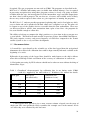
1
JR03:
RRS James Clarke Ross
South Georgia
Marine Biology
January 1993
This unpublished report contains initial observations and conclusions. It is not to be
cited without the written permission of the Director, British Antarctic Survey.
Copyright ©1998 British Antarctic Survey.
Cruise Report
RRS JAMES CLARK ROSS
Cruise JR03
Pelagic Ecosystem Studies
South Georgia
January 1993
CONTENTS
1
1.
Summary
2.
Narrative
3.
Biological Studies
3.1. Fish Biology
3.2. Secondary Production
3.3. Krill Ecology
4.
Gear
4.1. Net Sampling
4.2. Electronics Support
14
14
15
5.
Scientific Instrumentation and Logging
5.1. Acoustics
5.1.1. Simrad EK500 Echosounder
5.1.2. Simrad EA500 Echosounder
5.2. Sonar
5.3. ADCP
5.4. Underway Sampling
5.5. Navigation Logging
5.6. Event Log
17
17
17
19
20
22
24
30
33
6.
Computing
6.1. Vax Software
6.2. PC Software
6.3. Network Performance
6.4. Sun Software
6.5. Discussion
6.6. Problems with Level ‘C’ Software
6.7. ABC System: Data Capture and Analysis
6.8. Computer Support
34
34
35
36
36
38
39
40
43
7.
Laboratories, Logistics etc
7.1. Laboratories
7.2. Cold Facilities
7.3. Other Facilities
7.4. Deck Work and Gear Handling
7.5. Scientific Hold
7.6. Scientific Manual
51
51
51
52
52
52
53
8.
Appendices
8.1. Crew List
8.2. Cruise Tracks
8.3. Event Log
54
54
55
59
3
6
6
9
11
Despite the need to spend periods of time trialing and proving gear I am pleased to say that
largely because of peoples diligence and professionalism, both in the UK and on the ship,
much of the gear and equipment was both ready and made to work succesfully, enabling us
to carry out a good deal of the programme as planned. Although some areas of work were
carried out more satisfactorily than others (problems encountered are largely covered in the
relevant sections of reports) it would have been unrealistic to have expected more and overall
I am of the opinion that most participants are happy with what was achieved.
Acknowledgements
Thanks are due to the great number of people at BAS HQ through whose efforts we were able
to get into the field. As always the success of these ventures is in no small way dependent
on the support that we get from the ship. I am pleased to say, that as usual, our science
received the highest possible level of support, for which fact we are all extremely grateful.
On a personal note, I would like to express my thanks and appreciation to all onboard who
made my job as chief scientist easier than it might otherwise have been.
2. NARRATIVE (PW)
31st Dec 1992: Scientific personnel, Master, Officers and Crew joined the ship at 1800 hrs
after a trouble free flight to the Falklands.
1st Jan: Most outgoing personnel left the ship at 0630 hrs. Cargo work and gear assembly
started later in the morning. Meeting with Captain, Chief Officer and Chief Engineer at
midday to determine sailing time. Requirements to prepare as much gear as possible before
departure and to reach Shag Rocks around dusk means departure at 1600hrs on 2nd.
2nd Jan: Gear preparation continued. RMT readied in morning and Multinet started in
afternoon. Party from ‘Abel J’ toured ship in late morning. Ship departed FlPASS at 1600,
muster stations called and starboard lifeboat launched. Once clear of Cape Pembroke
calibration of ADCP carried out.
3rd Jan: Personnel largely involved in preparation and fine tuning of gear and
instrumentation. Fine weather allowing people to acclimatise to life onboard. Underway
logging and acoustics commence.
4th Jan: Scientific watches start 0001 hrs. RMT deployed over Shag Rocks shelf after dark.
Z nets and water bottles for secondary production experiments undertaken as well.
5th Jan: Arrive Bird Island 1500hrs to disembark Peter Prince. Weather good and personnel
ashore for an hour. In the evening the vessel ran up a transect established on previous cruises
to the NW of Bird Island. CTD’s were carried out at 53 49s 38 16W and 53 11s 39 15W.
6th Jan: CTD’ s completed at 0500 hrs. Vessel then proceeded to start point for an acoustic
survey which commenced after the deployment of Z nets and water bottles at 1545. 30 mile
legs at 10 mile intervals, at right angles to the shelf break, were run at 8kts. Cruise meeting
in the morning to finalise the programme for the middle part of the cruise.
7th Jan: Survey continues in calm conditions
8th Jan: Survey finished at 0230 hrs. On basis of acoustic data main transect position was
decided on as 54 13S 36 08W to 53 32S 35 21W. Stations A-D are located 10 miles apart
along the middle part of the transect. A CTD transect (10 drops at 5 mile intervals)
commenced from the inner end of the transect.
9th Jan: CTD’s completed around 0300. ADCP/acoustics run back to inner shelf complete
by 1100 hrs. At this point it was intended to intensively use the multinet to fish each of the
4 stations 3 times by day and the same by night. Gear problems with the multinet and the
RMT (not acknowledging the closing signal) frustrated attempts to properly start this part of
the programme.
10th Jan: Early morning spent target fishing for krill using the RMT. Some krill encountered
but the presence of salps caused one of the nets to split. The multinet was then succesfully
used throughout the rest of the day, although few larval fish were encountered.
11th Jan: Multinet aboard in the early hours of the morning when power was lost to the
system. Investigation showed that the termination needed remaking. Schedule re-jigged in
light of the gear problems and also in view of the lack of fish larvae. It was agreed that this
work would be concentrated at the inner end of the transect and in the bays.
ADCP/acoustic runs undertaken along the transect in the morning. Multinet ready later in day
and target fishing for krill commenced. F-net deployed in evening which resulted in live krill
which were set up in jars for moulting experiments. Multinet fished krill swarms during the
night and early hours.
12th Jan: ADCP/acoustic transect commenced but abandoned as weather deteriorated.
Decision made to retire to Cumberland East Bay to undertake fish work.
13th Jan: Multinet worked well, encountering of all things dense krill marks. A comparison
with the RMT was not possible as the release gear leaked. Agassiz hauls carried out on the
inner shelf over muddy ground in the late morning provided demersal fish samples. Vessel
3
then proceeded out onto the transect again to target fish for krill. By late evening vessel had
been stopped to examine the commutator on the aft motor, pending a decision on whether to
remove the brushes. It was hoped that a reply from Cegelec by next morning would solve the
problem. Overnight the ship on thruster power only. Z net and water bottle sampling
undertaken.
14th Jan: Decision made to lift brushes and ship underway again on one motor by 1100hrs.
Target fishing again with a useful multinet haul in the evening providing krill.
15th Jan: ADCP/acoustic run started just after midnight and target fishing again during
daylight. Vessel repositioned at outer end of transect to undertake repeat CTD transect.
Weather rapidly deteriorated from 2300 hrs onwards. Radio sched with Bird Island in the
evening. They relinquish their option on the 48 hour slot they had at the end of the
programme.
16th Jan: On thruster power overnight. Recommenced CTD’ s at 0800 hrs as weather had
moderated. Cruise meeting at 1000 hrs to discuss remaining programme.
17th Jan: CTD transect completed at 0500 hrs followed by ADCP calibration and noise
trialing for scientific echo-sounder.
Zooplankton work using the LHPR scheduled to begin at midday. Unit deck tested OK but
failed to function properly on deployment and was recovered. Problem was found to be a
short circuit in the flow meter wiring to the co-axial cable. Relaunched but powered out at
200m. Restarted but it was obvious from the gauzes that it had wound straight through. RMTl
rigged and used instead of LHPR and worked well with the DWNM.
18th Jan: Stations sampled in turn using RMT. Z net also deployed.
19th Jan: Completed zooplankton sampling at 1000 hrs. LHPR water tested again and
functioned correctly. A great relief but a little too late to make full use of. Target fishing then
commenced on the inshore end of the transect primarily to gather data on characteristics of
targets seen acoustically and to continue trialing with the multinet. Vessel moving to the east
of the main transect down towards Royal Bay.
20th Jan: Target fishing continued through the night. Plenty of krill swarms observed and
fished through on a number of occasions. Break off at 1400 hrs and head towards Cumberland
West Bay to commence fish work.
21st Jan: Overnight multinet hauls went well. First daylight hauls indicated net had not fired
and on further investigation it was discovered that a transistor had burnt out.
Agassiz hauls, Z nets and another ADCP calibration continued during the day.
22nd Jan: Multinet up and running again. Agassiz hauls in the morning and acoustic noise
trialing in the afternoon.
23rd Jan: Continue with multinet in quite windy conditions. Component failure experienced
around dawn so a change made to the RMT. CTD's carried out at mid points along transects
into bays. Wind force 7 by afternoon making it difficult to work the inner shelf. Vessel
proceeded to King Edward Cove where anchors dropped and ships personnel put ashore for
an afternoon. Ship visited by civilian harbour master and commanding officer of garrison.
Vessel departed 1600 hrs for Cumberland West Bay.
24th Jan: Final night of fishing in the bays and a comparison between the multinet and RMT
systems undertaken. Vessel proceeded to Leith Harbour for the echo-sounder calibration, tying
up at the buoy in flat calm conditions at around 0700 hrs. CTD deployed and acoustic
calibration commenced. Succesfully completed by 1500 hrs. Uplift of Husvik personnel
undertaken by ship. Most scientific personnel ashore for an hour or two in the afternoon.
Vessel departed Leith 1930 hrs for Shag Rocks.
25th Jan: Out along the shelf further acoustic noise trialing commenced around 0300 hrs.
LHPR water tested again succesfully at 1100 hrs. Arrived Shag Rocks early evening where
Z nets and water bottles were initially deployed followed by two multinet hauls.
4
26th Jan: Work complete by 0200 hrs. Ship enroute for Mare Harbour at 12kts. Demobilisation of cruise started with gear dismantling and stowing away of cargo. Scientific
watch keeping ended at midday.
27th Jan: Packing and cleaning of gear continues. Good progress made in calm weather.
28th Jan: Vessel alongside Gold Rover in Mare Harbour by 0800 hrs. Bunkering started
shortly afterwards. Labs and scientific hold cleared of gear which was transferred to the
afterdeck under tarpaulins. Scientific hold and labs swept cleaned and scrubbed out as
appropriate. Depart Mare Harbour early afternoon. Tie up at FIPASS 1700 hrs.
29th Jan: Scientific personnel assisted with transfer of cargo to shore and stores to ship.
Majority departed ship 1100 hrs, except some ISG personnel who were effecting a changeover
with their counterparts for the Geophysics cruise.
5
3. BIOLOGICAL STUDIES
3.1. Fish Biology (MGW)
Five objectives were set for ichthological study during the MLSD research cruise to South
Georgia during January 1993. These were:
1. Sample neritic larval fish to observe interannual variations in occurrence, composition
and abundance
2. Collect samples of Lepidonotothen larseni to investigate muscle structure and
development.
3. Sample neritic larval fish at Shag Rocks for comparison with the South Georgia shelf
assemblage.
4. Sample larval fish across the junction between continental shelf and slope at South
Georgia to assess relations with physical oceanographic features.
5. Collection of young fish for age and growth studies.
: a summary of work on these topics is given below.
3.1.1. Interannual variations in young fish occurrence, composition and abundance at
South Georgia.
Introduction: The main objective of this study is to make collections of larval fish at sites
that are regularly sampled during OBP/PES studies to accumulate data about the overall levels
of interannual variation in occurrence, composition and abundance among the early stages of
the demersal fish at South Georgia.
Methods: A longitudinal transect was established in Cumberland Bay East divided into inner
and outer sections. Physical characteristics were measured along the transect by means of
underway Ocean logger and ADCP and the characteristics of the water column by use of a
CTD profile at the midpoint of each section.
The zooplankton was sampled by RMT8+1M initially for direct comparisons with former data
(North and Murray 1992) and then by Multinet samples for more detailed observations of the
vertical distribution patterns. The Fnet was used for collections in the O-2m range. The
transect was occupied on two occasions: the first for one day and the second for three days.
During each 24 hour period, two hauls during daylight and two hauls during darkness were
conducted along the transect. The Fnet was deployed for 20 minute twice while an RMT or
Multinet haul was in progress. Each RMT deployment was three 30 minute oblique hauls
over the range O-210m while the Multinet deployment was operated over a similar depth
range with each oblique was divided into three depth strata O-70, 70-140, 140-210m. each
strata sampled for 10 minutes three times. Total wet-weight biomass of the samples was
estimated by displacement. The major components of the samples were then recorded. All
fish were extracted, identified, measured and fixed for subsequent investigation.
Observations. The physical conditions prevailing during the study were very similar to those
encountered formerly. Temperature declined steadily from the surface without any major
6
thermocline. ADCP profiles were collected and have yet to be evaluated but examination of
the current direction/strength vectors against depth along the transect suggested a region of
relative stasis at 80 m.
RMT8 collections during the first period of investigation showed that the larval fish
assemblage was restricted in diversity and abundance in comparison with the former detailed
study and differences in size range of the species captured. Collections with the Multinet
during the second period of study were similar in composition and abundance to those during
the first period. Among the fish sampled, young Trematomus hansoni were the most
abundant larval stage present, followed by decreasing numbers of Lepidonotothen nudifrons,
Artedidraco mirus, Champsocephalus gunnari and Gobionotothen gibberifrons. The marked
differences in composition and abundance values between years (1987, 1991, 1993) suggest
large interannual differences in recruitment by demersal fish at South Georgia.
3.1.2. Investigate muscle structure and development in Lepidonotothen Larseni.
Introduction: The main objective of this study was to collect samples of young L. larseni to
investigate the muscle organisation and structure during early development. These samples
are required to continue the research, in collaboration with St Andrews University, about the
energetics, activity and muscle development of Antarctic fish from difference niches.
Methods: Samples of juvenile L. larseni were collected by Agassiz trawl during 20 minute
tows on the inner shelf adjacent to Cumberland Bay East. Larval fish were obtained from the
routine RMT and Multinet hauls. Specimens were identified, measured then preserved in
Bouins formal/acetic/picric acid fixative.
Observations: Samples of the bentho-pelagic juvenile stages were readily captured using the
Agassiz trawl during daylight. The pelagic larval and early post-larval stages were rarely
encountered among samples of ichthyoplankton at any locality during the course of JR03 but
a small number (<20) where accumulated from catches. These and the juvenile specimens will
be presented for histological investigation by Professor Ian Johnston’s rersearch group at St
Andrews.
3.1.3. Larval fish at Shag Rocks
Introduction: The main objective of this element of the study was to collect samples of
larval/post larval fish for comparison of size and development for species also occurring on
the shelf at South Georgia. Observations during JB 11 (1991) suggested that large but
consistent size differences were to be found when comparing the size of Champsocephalus
gunnari at each locality. It was not possible to determine whether these size differences were
due to greater age or faster growth during JB11 .
Methods: Samples were collected after dark using the RMT8+1M and Multinet as multiple
oblique hauls from surface to near the sea-floor. Fish were extracted from the catches directly
after capture, identified, measured and then fixed in 70% alcohol to retain the integrity of the
otoliths.
Observations: Larval Patagonotothen guntheri dominated the catches at Shag Rocks but
Harpagifer georgianus, Champsocephalus gunnari, Lepidonotothenlarseni, Notolepis coatsi,
7
Racovitsia glacialis, Electrona antarctica and Protomyctophum choriodon were also
represented in small numbers. Few C. gunnari were collected at Shag Rocks and from
sample sites at South Georgia. No marked size differential was evident between specimens
collected at Shag Rocks and South Georgia. Examination of the otolith microstructure will
be used to reveal the hatching dates at both localities.
3.1.4. Larval fish distribution in relation to the junction between continental shelf and
slope at South Georgia
Introduction: The main objective was to investigate the composition and structure of the
larval fish assemblages in relation to the oceanographic features associated with the junction
between the oceanic and neritic biota at South Georgia This was undertaken to address the
question: ‘What mechanisms are responsible for maintaining the neritic communities with
extended pelagic phases at an oceanic island such as South Georgia’?
Methods: The initial oceanographic data was determined by means of a box survey overand adjacent to the northern continental shelf of South Georgia (using acoustics, underway
Ocean Lopper and ADCP) to provide circa-synoptic observations of zooplankton biomass,
temperature, salinity, fluorescence and water column structure. This survey showed that the
major parameters were aligned parallel to the bathymetry. A 50nm transect was selected for
detailed study by inspection of this data, across the shelf into oceanic water at a locality with
high densities of zooplankton (krill) biomass. Oceanographic data was collected along the
transect at the beginning and end of the survey period by means of CTD profiles at 5 mn
intervals to demonstrate the vertical structure and Ocean Logger observations to illustrate the
horizontal structure. ADCP profiles were also obtained. The composition and abundance of
the zooplankton was determined by Multinet, RMT8 and Fnet samples in the upper 210m
from 2 shelf stations and 2 oceanic stations located along the transect on either side of the
shelf break. Stations were to be occupied during daylight and darkness and replicated three
times. Samples were worked up as for objective ‘1’.
Observations: Samples collected from both the oceanic and neritic segments of the transect
were almost devoid of larval fish. Salps or krill were the dominant component of the
zooplankton in the upper 210m. The lack of larval fish and hazard to net operation owing
to the high numbers of salps resulted in the ichthyological element of the investigation
beginning deferred. Oceanographic and zooplankton results may still well be able to used to
address part of the query.
3.1.5. Age and growth studies.
Introduction: Samples of larval, postlarval and juvenile fish were collected during JR03 for
age and growth studies to determine such events as hatching dates and growth patterns during
their early life history. The nototheniids, Gobionotothen gibberifrons, Notothenia rossii, N.
neglecta and the Channichthyid, C. gunnari were the target species. Estimates of growth rates
and development patterns have been derived so far from time-series collections or
extrapolation using hatching dates from the literature. The objective is to use micro-increment
analysis of the otoliths as a means of validating estimates of age, determining dates of
hatching and examining the growth patterns during the first year of development. Thereby
producing more accurate values for growth and a description of growth patterns during the
critical pelagic phase.
8
Methods: The majority of samples of young fish collected during JR03 were fixed and
preserved in 70% alcohol therefore most of the fish collected during the Cruise will be
suitable for age and growth investigation.
Observations: Few larval fish were encountered during JR03 over the shelf at South Georgia
and so the majority of the specimens collected were from Shag Rocks and Cumberland Bay
East. The large numbers of postlarval P. guntheri from Shag Rocks should be useful in
determining the early growth history of this species.
Acknowledgements.
It is very appropriate to gratefully acknowledge the professionalism, help and support afforded
by the Officers and crew on RRS James Clarke Ross and well as the invaluable work
undertaken by ISG staff during the cruise. I also want to thank fellow MLSD participants for
their considerable help, support and encouragement without whom I would not have been able
to undertaken any of the work.
3.2. Secondary Production (PW, RS)
Experimental work this year was concerned with the initiation of a new project investigating
egg production in Antarctic Copepoda. Rhincalanus gigas and Calanus similiimus were
selected for study based on their abundance and reproductive status at this time of year. Later
in the cruise, Calanoides acutus was also sufficiently abundant to undertake some incubations.
Live animals were obtained by deployment of a vertically hauled ring net (Z net) from the
mid-ships gantry using the SAPS winch which remained onboard from the STAP cruise. Nets
were veered to 200 m and hauled slowly upwards to the surface. Water to incubate live
animals was collected from 20-30 m depth using 301 Go-Flow bottles loaned by RVS.
Catches were sorted under a Wild M5 microscope using a cold light source. Live females
were transferred either individually or in batches of 5 or 10 into tubular perspex cylinders
closed off at the lower end with 800 micron netting. These were suspended in 1.51 jars filled
with sea-water and placed in incubators running at ambient sea-water temperature (3.5 - 4.5°
C). The catch residue was then preserved for further analysis. 24 hour incubations (short term)
and longer were undertaken. In the former case experiments were taken down after the
elapsed time, eggs produced were counted and females preserved. Longer term experiments
were subject to water changes every 24 hours or so, after which eggs produced in the
preceding 24 hours were counted. Females in long term experiments were initially subject to
a number of different regimes. Some were maintained in filtered sea-water, some at half
ambient particle concentration and others at ambient concentrations. Negligible egg production
in all 3 combinations caused the termination of this part of the programme and the transfer
of all long term experiments to ambient concentrations in the grazing wheels, where we were
sure that females would be in contact with food at all times. Although under these conditions
females were also in contact with their eggs, losses due to predation were thought to be low.
Usually only a small number of egg membranes were recovered in the water siphoned off
every day alongside the freshly laid eggs. Whether egg production under these conditions
increased significantly with respect to containment in the perspex inserts will have to await
statistical analysis. More faecal material was however observed in the grazing wheel jars, the
conclusion being that food could be a limiting factor under the original experimental
9
conditions.
At the time that each short term experiment was set up, or in the case of long term
experiments, water changed, samples of sea-water were preserved with Lugols Iodine and
a sample run through the multisizer. From 12/l/93 chlorophyll samples were also taken. These
data should allow us to look at the effect of chlorophyll levels and phytoplankton species
composition on egg production. On three occasions during the course of our studies, relatively
high levels of egg production appearred coincident with elevated levels of phytoplankton and
an increase in species diversity. These observations were made at Shag Rocks on 5/l/93 and
25/l/93 and off Royal Bay on 20/l/93. This part of the study will be looked at carefully in
conjunction with work already underway within the group on food selectivity in copepods.
All gear and other equipment used in these studies performed well (although see Gear
Report). One Z net was lost through failure of a Karabiner.
It had been hoped that the newly acquired LHPR system could be used to obtain profiles to
monitor diurnal change in the depth distribution of female copepods and to see where in the
water column copepod eggs were most abundant. Unfortunately this was not possible this year
despite great efforts by Paul Woodroffe to overcome some of the software problems (See his
report). Our patience was rewarded towards the end of the cruise when on a couple of
occasions the system functioned properly in the water when tested. I am confident that the
major problems have now been overcome and that in future years we will have a viable
system.
10
3.3. Krill Ecology (HH)
3.3.1. Background
The restriction of the pelagic larval stages of some neritic populations of Antarctic fish to the
on-shelf area suggests a continental shelf-break front. This shelf break is an area where krill
swarms are often found, which begs the question why should krill be present, sometimes in
great quantity, in a zone which may be acting as a boundary for some ichthyoplankton and
zooplankton species.
3.3.2. Specific Objectives
The primary objective for this cruise was to investigate the nature and geographical position
of krill in relation to the physical and biological features which make up the shelf-break zone.
This study was designed in conjunction with the Fish group in order to maximise the effort
allocated to water structure discrimination and minimise time required for travel between
study sites.
A secondary objective, contributing further to work done in the vicinity in previous years, was
to get an estimate of the growth of freshly caught krill, with a technique known as the
Instantaneous Growth Rate (IGR) experiment.
Tertiary objectives include work done to extend the data on distribution and
length/frequencies of krill collected on past cruises, and the preservation of krill for further
biochemical analyses to extend the dataset on krill feeding (gut fluorescence, gut fullness,
etc.) started on JR02.
3.3.3. Sampling Protocol
A grid survey was conducted to site the krill/fish transect in a position perpendicular to the
shelf break zone where krill could be expected (see Appendices 8.2.2. and 8.2.3. respectively).
The transect ran offshore/onshore with the shelf break zone lying across its midpoint. The
hydrographic structure along the transect was then investigated with a series of ten CTDs
stationed 5nm apart. Following this, two separate periods of 24 hrs were used to investigate
the geographical position, biomass and structure of krill swarms in relation to the
oceanography of the shelf break zone.
ADCP/acoustics runs were used to collect data on water structure and krill biomass along the
transect, and krill were sampled by Multinet after searching for suitable targets using a zigzag track along the shelf break. The krill targets were looked for in a corridor delineated by
depths of about 200m and 500m in the onshore/offshore direction, and a distance along the
shelf break estimated to be within the applicability of the transect oceanographic data. The
extent of the corridor will be shown more precisely when ship track data are available for
these periods.
In the first 24 hr period allocated to krill studies (Kl), two blocks of 6 hrs were to be used
for ADCP/acoustics transecting, and two blocks for krill target searching and fishing. For the
second 24 hr period (K2), these blocks were to be organised in a different order so that, at
the end of the allocated krill time, effort at each activity would have covered both daytime
and nighttime equally. In the event, one ADCP/acoustics run was abandoned due to bad
weather, and a last run was sacrificed to gain more searching and fishing time, as suitable day
targets had been hard to find.
11
3.3.4. Data collected - Krill data
The following lists the events where krill and krill data were collected.
1.
Event 019/020
RMT Net 1 fished open all the time, so no depth
discrimination. 100 animals measured and matstaged.
2.
Kl-Event 031
Multinet fished through ‘salpy’ diffuse layer, 2 mins/net. Krill
in nets 1 & 2 frozen at -60 for later biochemical analyses and
length/matstage measurement.
3.
Kl-Event 033
F Net caught enough live animals in good condition for an
Instantaneous Growth Rate (IGR) experiment to be set up.
4.
Kl-Event 034
Multinet. Krill in nets 1,2,3,4 & 6 into -60. Clean catches, salps
avoided. IGR set up from net 4.
Kl
1 acoustic/ADCP run completed, 1 aborted due to bad
weather....headed for Cumberland Bay for MGW.
7.
Event 038
Cumberland Bay opportunistic krill from MGW’s nets
Nets 6,7,8, & 9 had krill. Froze 4 trays (112 animals) from
each. Swimmers in 9,8, & 7 were set up in the cold room for
6 hrs for faecal strings - for comparison with material from
oceanic stations. Matstaged and measured 100 krill from 9,8, &
7 afterwards.
8.
K2-Event 044
Multinet. Salps.
9.
K2-Event 045
Multinet after lots of searching. Krill in nets 4 & 9. Animals
from net 9 to -60.
10.
K2-Event 054
Multinet. 100 krill measured net 6.
11.
K2-Acoustic/ADCP run
12.
Event 058
Multinet on target. Catch sorted.
13.
Event 076
LHPR test deployment caught krill. Put swimmers in after deck
tank and started IGR. Froze some in -60.
14.
Event 104
4 trays frozen in -60.
15.
Event 105
Target multinet for DGB towards Royal Bay. 100 krill
measured in nets 1,3,5 7, & 9. Some krill in other nets.
5 & 6.
For catch details and other opportunistic measurements of krill, see length/frequency logs and
catch logs held by Cathy Goss.
Most of the krill that were successfully target fished were immediately frozen at -60°C for
matstaging, measurement and biochemical analyses later.
The krill and moults that were produced by the IGR experiments were fixed for matstaging
and measurement later. The intermoult periods were calculated at the end of the experiments
(see Table 1)
Table 1. Krill Moult Data
Event
Number
IGR code
Net type
Date/start time
(YYJJJ
HHMMSS)
Number
moulted
Inter-moult
period
E033
IGR1 Red
F net
93012 000641
12
33.3 days
E034
IGR1 Blue
Mnet 4
93012 032219
15
26.7 days
E076
IGR2 Blue
RMT
930 18 030954
12
33 days1
1. One
animal
dead
3.3.5. Data collected - Supporting data
For CTD data and oceanographic interpretation, Carolyn Symon (CS) should be consulted.
For thermosalinograph salinity calibration, see CS.
For ADCP raw data, PNT should be consulted, and for oceanographic interpretation of this
data, see CS.
For acoustic data, and acoustic transect events, CG should be consulted.
For underway monitoring data, e.g. Sea Surface Temperature, fluorescence, etc., see AGW.
3.3.6. Specific contributions by other personnel on the cruise
The Multinet, RMT and Fnet were designed and managed by DGB
ISG personnel (Paul W, VA, GB) contributed DWNM, CTD deployment, data handling and
PC support
The EK500 was driven by CG
The ADCP was driven by PNT
Underway monitoring was managed by AWAM
Data management and transportation was done by AWAM & PNT
13
4. GEAR
4.1 Net Sampling (DGB)
This cruise has seen the first real use of two major new items of gear developed within
MLSD and ISG, these are the Horizontal Antarctic Multiple Plankton Sampler (H-AMPS)
and the Down Wire Net Monitor, (DWNM). Both were conceived in the early 80’s, the
DWNM having to await the arrival of JCR with a conducting towing cable before it could
be developed.
Although both items require further refinement, their performance on this cruise has fully
justified the faith placed in the original ideas. Used in combination they comprise a very
potent sampling tool.
The H-AMPS employs 9 seperate cod-ends to sample catches by a single fixed 2m2 mouth
net, the whole being mounted in an aluminium frame. Sample intervals can be as short as 10
seconds allowing discrimination between targets only 20m apart. The overall design
incorporates features that are intended to minimise the nets detectability by plankters and so
reduce avoidance.
The DWNM which is replacing the limited and now unreliable acoustic system that we have
used for many years is designed as a sensor package with command functions. Both the
physical design of the underwater unit and the surface software allow the sensor suite to be
varied according to the gear or sampling method being undertaken.
At present we have sensors for depth, temperature, conductivity, PAR, flow rate, and cylinder
angle (horizontal = 0 degrees). We have a futher sensor to give height off the bottom (max
50m), which we failed to get working owing to a (soluble ) problem with the power supply.
The system runs from a PC, for which Paul Woodroffe, who has also been responsible for
the electronics, has produced very user friendly software. Commands are acted upon instantly
and reliably direct from the keyboard.
On the cruise we have used the system successfully with RMT, H-AMPS and LHPR.
Most sampling over the stern has been done with the 13mm conducting cable (‘Biological
Winch’ wire.). This system has no compensation to maintain wire tension when the ship is
pitching. However the winch does have a tension control that will allow wire to pull off when
tension goes above a preset point and this can be used to cushion the snatch experienced
when the vessel pitches forward. The electrical part of the electro mechanical termination
failed at one point but this was soon repaired. However the termination has several
undesirable features and I will be looking at better ways of doing it for the future. I would
expect that we will be able to go right through a long season without the need to re-terminate
the cable due to general wear and tear.
The cable monitoring unit, a three sheave system to give tension, rate of veer/haul and
length of wire out is rather vulnerably mounted just outside the spurling pipe. Its electrical
connections leave much to be desired and the mounting position leads to erratic readings on
the rate meter when the gear is near the surface and the vessel pitching. These points have
been addressed in a request submitted to the ship for work to be done during refit.
14
The Scientific Communication System which allows a net launcher on the afterdeck to talk
directly to the winch driver in the UIC was inoperative following a fire in its control panel
prior to the cruise. This is a very valuable feature and must be restored. The only alternative
is a two way radio which requires a spare hand to operate, often, just when both hands are
required for net launching.
During the cruise a simple wire drier was made for drying the conducting cable before it
goes down the spurling pipe, the prototype was very successful and further examples will be
made.
The ‘F’ Net was operated from the scientific EFFER crane on the foredeck, this worked well
and does allow for easy change in depth of the net if required. The net fishes well out from
the bow wave.
Vertical nets were operated over the side gantry using wire from the ‘Clean chemistry’ winch
supplied by RVS for the STAP cruise. This is not a long term solution to the serious problem
created by having the hydrographic wire included in the traction winch system. The problem
will have to be addressed at an early opportunity and a solution found.
4.2 Electronics support (Paul W)
I spent most of my time on this trip developing a new system, the Down Wire Net Monitor,
and fortunately my colleague, Vsevolod Afanasyev, has found a natural affinity for CTD
deployments which gave me plenty of time for software re-writes and hardware modifications.
4.2.1. Down Wire Net Monitor
Cruise JR03 has provided a difficult and extremely useful trial for the Down Wire Net
Monitor system, the results of which have been, or will be, implemented to make the system
fit the user requirement more closely and with maximum reliability. I am happy that we can
deal with all of the problems that are outstanding on the system and, as the system was used
with RMT, MultiNet and LHPR, I am confident that we have already encountered all the
serious snags that were awaiting us. The outstanding problems that need addressing are as
follows:
1) The 24V Power supply, which is used for the pinger and the battery trickle charger,
generates too much noise when under heavy load - this effectively jams the communications
link and thus the pinger was not used.
2) The LHPR flowmeters do not register.
3) The ABC system level B port occasionally hangs up causing data loss.
4) Occasional communications errors - I am hoping to reduce these to almost zero at
9600 baud (which is the data rate we currently use) and to increase the baud rate to 19200
with the same level of reliability.
I am delighted with the reliability of the system, which, in combination with the
MultiNet, has contributed towards the success of this cruise.
4.2.2. CTD System
Technical snags on the CTD system were limited to connection problems and no planned
15
deployments were lost. Unfortunately, due to an administrative error, we were only able to
use 6 Niskin bottles on this trip. Fortunately this did not prove to be a handicap.
4.2.3. Oceanlogger System
With reference to Mr Murrays report, we will try to address the relevant criticisms of this
system at the nearest opportunity, though with reference to the comments about data
averaging and sample rates - the system software is designed to fulfil the ABC philosophy
that all data processing should be performed at level C unless, as in the CTD system, the data
rate of the instrument is greater than 1 sample per second. The sample period on the
Oceanlogger, which goes down to 1 second should, according to Mr Nyquist, allow the user
to observe data with a period of 2 seconds (O.5Hz). This should be adequate for most user
requirements, surface sampling wise, and fully meets the design specification - er......there
wasn’t one.
There are obvious hardware problem with this system, some of which may have been
caused by the enormous waves that engulfed some of the met instruments during JR02 and
obviously we will attempt to rectify these as soon as possible. The problems with the
thermosalinograph are extremely disconcerting and merit considerable investigative effort.
4.2.4. EK500 Echosounder
This system proved reliable throughout its first operational season - a far cry from the
dreadful EK400, and proved to be a useful scientific tool. I am a little worried by the results
of the Leith calibration which show a considerable change in the system since the Potter Cove
calibration, performed at the beginning of JR02. I suggest that we contact Simrad for their
comments on this.
16
5. SCIENTIFIC INSTRUMENTATION AND LOGGING
5.1 Acoustics
5.1.1. Simrad EK5OO Echosounder (CG)
Operation
a) A set of menus and submenus are used to send commands to the sounder and allow users
separate control of the screen display, printed output and integration parameters. Although
some limited use was made of kermit to transmit commands, this was slow and unreliable,
most of the settings were selected manually; this is generally quite rapid with a short list of
options for most frequently used items. The menus have the disadvantage that it is easy to
use different settings for the printer and display, and because there is a time delay before the
printer records become visible, the printed output was wrongly set on a few occasions. A
paper record was made of all settings at the outset of the cruise (these were as used by Jon
Watkins on JR02) only a comparatively small number were regularly altered: logging
interval, layer picture, noise margin and thresholds being the most significant, others affected
the display and printed record.
a) The joystick control on the main unit is already showing signs of deterioration and
probably should be replaced; if not pushed forcefully enough commands were not always
entered immediately, and in some situations this could mean that the chart was marked late,
or integration was interrupted.
c) Software for logging integrated output from the EK500 was written by Paul Woodroffe in
LabWindows. It provides a method of saving raw and converted integrator results and
comments in three separate files, with a continuous readout of the file sizes being
accumulated. Dave Richmond began the process of logging the sounder to the ABC system
via the Ethernet Port, establishing a connection between them the day before the unit was
dismantled and removed from the UIC room.
5.1.1.1. Data Collection
Phil Trathan, Alistair Murray and I together ran the sounder for most of the time when the
ship was underway south of the APFZ Rates of data collection with different combinations
of reset interval and layer configuration have shown those which are practical for various
types of survey. Almost all of the time the maximum layer number (500) was used to give
lm layers over the top 250m at two threshold levels, The data from only one of these levels
will be used and on future cruises when the effect of the threshold has been established, only
one will probably be needed. A test file using 10 different thresholds over the same depth
range, with 36 second reset intervals, was run when both dense and diffuse targets appeared
in the water column. This should produce comparative data to determine the best level to use
in future. The shortest acoustic runs while nets were being towed used reset intervals of
between 36 and 60 seconds. The shortest interval available is 14.4 seconds, but such short
times produced unmanageably large files. Longer transects were logged at 2 - 3 minute
intervals. Over 22 days of survey over 240Mb of data were collected and two copies of each
file backed up approximately daily onto 80Mb cartridge tapes. Over 12 RMT events 33
multinets and around 83 transects had acoustic results logged.
17
5.1.1.2. Calibration
A sphere calibration was carried out at Leith Harbour on 24 01 93. Starting at 1000 hrs
GMT, measurements were taken from 23mm (for 120kHz) and 60mm (for 38kHz) diameter
copper spheres provided by Simrad, at standard and working pulse lengths and band widths.
A 38.1 mm tungsten-carbide sphere was also used at both frequencies for comparison with
earlier calibrations. The calibration was simplified by using previously measured and marked
lines to suspend the spheres under the ship. The 23mm sphere also needed to be suspended
above an extra weight (the 60mm copper sphere was used for this purpose) to counteract
movement as the ship swung in the wind. 8 hours were needed to complete these
measurements. There was not time to carry out the lobe program.
5.1.1.3. Interpretation of Echoes
5.1.1.3.1. Echoes from Non-Biological Targets
a) Net control switching - old net monitor: On some occasions a dense spike, familiar from
the EK400 charts, appeared, while on other occasions the only evidence of this was an
interruption in the bottom trace.
b) False bottom echoes: False bottom echoes were caused by reverberations between the
bottom and the surface. These were far more frequent than encountered with the EK400
sounder on the John Biscoe and often very strong. This could be explained by the
combination of good weather, the ship’s stability and other physical differences in parameters
such as beam width or transmit power. Two strategies could be used to avoid these echoes
or stop them once they began. The first is to select a slower ping rate (and lose detail) and
the second is to have someone continuously monitoring the depth and adjusting the depth
window to a realistic range until the water depth is greater than about 1000m.
c) Noise
(i) Internal: We encountered a major drawback with this sounder on sea trials: high noise
levels at 120kHz even before the transducer was plugged into the system. Although some
improvement was made when part of the hardware was returned to Simrad in Norway the
levels still appear high in comparison with the EK400. Evidence for this comparison comes
from watching targets migrating up or down through the water column that appear or
disappear into a ‘blind’ zone on the 120kHz display that starts at around l00-150m depth.
Only the strongest echoes are visible below this depth. The composite chart that recorded
alternate pings from the two frequencies used on the EK400 may have masked a similar depth
limitation on weak echoes from 120kHz. Comparison of calibrated results from both sounders
should resolve this uncertainty.
(ii) External: At the start of the cruise when travelling at 12-13knots between Stanley and
South Georgia, I used the sounder’s passive mode (ie listening to the ambient noise in the
water column) to establish what value to use for the sounder’s noise margin setting. (The
calm crossing we had was ideal for this). This parameter provides a filter for all signals
below the chosen level. The manual recommends that it should be kept as low as possible
but a 7dB setting was needed to remove all but the smallest trace of noise when displayed
using -82dB colour minimum setting. Having fixed this level at 12 knots I was surprised to
encounter an additional level of noise at 12OkHz that only first appeared when we sailed off
18
the shelf after calling at Bird Island. I decided not to mask it with a further increase of the
noise margin but instead logged its appearance and disappearance. It is clearly connected in
some way with the ships propulsion system, switching off sharply a short while before the
ship stopped for any reason and starting suddenly as soon as the ship began to get underway.
This pattern of occurrence was further modified by the ship travelling on and off shelf but
in the reverse way to that usually encountered: more noise encountered off-shelf and less onshelf.
(iii)
Noise Trials:
Four separate sets of noise trials were carried out using passive and active modes, at both
frequencies, both on-shelf and off-shelf. They were aimed at understanding the speed-related
noise described in the previous paragraph and at providing a record of the noise encountered
at speeds used for different work activities performed. Following noise measurements made
during sea trials in summer 1992, 8 knots was chosen as the preferred speed for transects
where acoustic survey was the primary or an important aim. The first test on 16 January used
an octagonal track devised to test the effect of wind direction in relation to ship’s direction,
but, owing to the light wind, it was only possible to make straightforward observations on
noise levels at around 8 knots (100 shaft rpm) at both frequencies in passive mode in deep
water. The lack of strong wind throughout the cruise prevented a full series of comparisons
that would have been possible with this track design, where one leg was in the same direction
as the wind and the remaining legs turned through 45” until a regular octagon was completed.
The subsequent three tests were made when time was available between other activities using
sections of straight course. On the 17 January different speeds were tested in active mode
with settings as close to usual operational ones as possible. The engine was run in both
normal and quiet modes; the latter mode was considerably noisier at these frequencies at all
speeds. Quiet mode uses more fuel than normal mode and is not recommended for acoustic
surveying.
5.1.1.3.2. Echoes from Biological Targets
Separate charts for each frequency, density information displayed in colour, and variable chart
speeds mean that the echocharts do not look very much like the charts form the Simrad
EK400. Fishing with the RMT and multinet has provided evidence that particular marks on
the echochart were caused by krill and others by salps. Mysids were the only other targets
that were caught in sufficient quantity to attempt to correlate with chart marks. Where
substantial numbers of krill were caught during target fishing, lengths of 100 animals (or the
total if that was less than 100) were measured.
5.1.2. SIMRAD EA500 Echosounder (PNT)
5.1.2.1. The EA500 ran successfully for the duration of the cruise. There were no software
or hardware problems encountered. Towards the end of the first half of the cruise Dave
Richmond successfully enabled the level ‘A’ interface so that the EA500 could log data
through to the level ‘B’. Data were therefore collected from 08/01/93.
There is no repeater screen for the EA500 in the UIC room which makes it difficult to
monitor data quality. The only indication available is from the level ‘B’ messages on the level
‘B’ console. These messages include the current depth. In normal practice, if the attached
recommendations are followed, this should be a satisfactory arrangement.
19
The EA500 is actually part of the ships navigation equipment and under the current standing
instructions the bridge make occasional changes to its setup. These changes are related to
manually altering the range settings. However, on a number of occasions the EA500 was left
with the wrong bottom settings. Near to regions where the depth changed rapidly (shelf break
areas), this had the result that a false bottom was detected at twice the depth of the true
bottom, or that a constant bottom was recorded at the exact depth of the bottom setting. This
false bottom was logged to the level ‘B’ on a number of occasions and as a consequence,
considerable care will be required to validate the data. It is possible that using the EA500 in
auto-ranging mode may alleviate some of these problems.
To reduce mutual interference, EA500 pinging was synchronised to the EK500. This meant
that if the EK500 was switched off, the EA500 was unable to ping until pingmode normal
was selected by the operator. Therefore, if the EK500 is not sounding, the bridge must be
notified so that the EA500 can be switched to pingmode normal.
5.1.2.2. Recommendations
If useful data are to be derived from the EA500, stringent protocols must be agreed with the
bridge to remove the possibility of false data being recorded. These protocols should include
instructions to run the EA500 in auto-ranging mode and for notifying the UIC room if the
EA500 setup is changed. Arbitrary changes should be discouraged. Similarly, to prevent
unnecessary error messages on the bridge, proposed changes to the EK500 pingmode should
be communicated to the bridge before they are made.
5.2. Sonar (AWAM, DGB)
5.2.1. A Furuno sonar model CSH 50 is installed on the RRS James Clark Ross. The system
is not presently connected to any navigation instruments; it can accept gyrocompass and log
inputs and is then capable of providing a “true motion” display. (We do not know whether
the data formats of our navigational instruments are compatible.) Two displays and control
panels are provided: one in the Underway Instrumentation and Control (UIC) room. and the
other on the bridge. The instrument in the UIC room is most inconveniently sited at the
opposite side of the lab from the EK500 sounder, Down-Wire Net Monitor (DWNM) PC and
winch controls. This severely limits its usefulness during fishing operations. The system
operates at 53 KHz. Interference from the sonar was visible on the scientific sounder - see
the report on the EK500 by Catherine Goss. There are a number of settings such as pulse
duration, TVG function and the like which can be set by dip switches on the instrument in
the UIC room. Instrument settings for our work will probably differ from those required for
navigation. The instrument in the UIC room should be configured with the appropriate
settings for the scientific work to be undertaken. The instrument which is first to be switched
on gains control of the displays; this should be the UIC room instrument when scientific work
is in progress. The UIC display is of noticeably poorer quality when it is acting as the slave
than when it is controlling the system. The sonar system is highly sophisticated and clearly
needs to be configured correctly, used appropriately and interpreted with care. Experience
on the cruise suggests that interpretation of the display is not straightforward - even given the
joystick-controlled cursor with (apparently) a read out of range and depth to target. The
display can be set to “slice” mode. This is not a vertical slice through the water - rather it
is an oblique section along the beam in the currently selected bearing relative to the ship.
20
The slice shows a combination of range and depth information (that is the depth is a function
of the range). Changing the gain setting can cause a marked change in the appearance of the
targets displayed.
5.2.2. Some observations on interpreting the sonar display
During net hauls in West Cumberland Bay the display was monitored to provide warning of
any change in bathymetry. Positioning the cursor on the edge of the bottom echo does not
give the true depth - when tested over a fairly level 200 m bottom the estimated depth from
the sonar was about 160 m. The first indication of rising sea bed was a narrowing of the
bottom echo rather than a change in range, presumably because the echo was sharper from
a surface inclined towards the ship.
During net hauls with the multinet we attempted to use the sonar to measure the depth of the
net - which was known accurately from the pressure sensor mounted in the DWNM. By
varying the angle of tilt of the sonar it was possible to observe a return from the net over a
depth range of nearly 50 m. A strong echo was observable over a range of 20 m depth. It
was very difficult to get the estimated depth of the net correct - even with foreknowledge
of the true value!
During acoustic searches for suitable targets for krill fishing a careful watch was made for
targets ahead of the ship which might then pass through the EK500 beam. Several were
observed on both instruments. Invariably a target which looked large and strong on the sonar
display appeared relatively small and disappointing on the EK500 Careful choice of gain
and other settings on the Furuno might help to tune its sensitivity to provide more comparable
indications on both the Furuno and Simrad systems.
5.2.3. Use of sonar during krill target fishing
Undoubtedly the sonar will be of great help in target fishing operations but at present it seems
far better at detecting shoals of “red herrings” than anything else! With the present “ship’s
head up” display there is a great tendency to chase one’s tail until you are literally targeting
the ship’s wake!
If we were able to interface the sonar with the log and gyro to give a “true motion” display
there would be less tendency to do this. However, the same principle will apply, in that to
chase off after any likely target irrespective of where it appears on the screen will not be a
lot of help. In the limited trials that we carried out it was apparent that krill swarms did not
show up well at ranges greater than 3-400 m. Thus, if a target is more than a few degrees
off the ship’s course, the vessel would still be turning when (if) it passed over the swarm and
consequently the net would possibly not pass through the swarm at all.
To overcome these problems we think that we should purchase and study a copy of the
manual with a view to maximising the range at which swarms can be detected while
minimising the “rose-tinted spectacle” effect that makes the least little discontinuity look like
a krill bonanza.
Further, we do not think that the sonar should be used as an alternative to our well tried
acoustic search methods, rather, it should be used to fine tune the catching runs. We think
that a good scheme would be to get the search area centred on the VMS workstation display
21
and zoomed to the largest possible scale. When swarms are encountered on the search they
should be marked on the monitor screen with chinagraph. At the end of the search a suitable
course can be chosen to pass through the area of greatest likelihood of an encounter. Once
settled on this course the sonar should be set to concentrate on a very limited area, say 10°
either side of the bow and used to direct the ship only towards swarms that appear in this
window.
5.2.4. Recommendations
1) MLSD should purchase two (or more) copies of the manual.
2) We should explore the possibility of interfacing the ship’s gyro and log to provide a “true
motion” display.
3) We should decide what we want out of the instrument.
4)
Someone should be trained to use and interpret the sonar for our purposes.
5) The instrument should be set up appropriately.
6) The issue of who controls the instrument - scientists or the bridge - must be resolved and
working procedures agreed with ship’s officers.
7) During refit the problem of interference between the various acoustic systems should be
resolved.
5.3. ADCP ( P N T )
5.3.1. ADCP status
The RDI 150kHz ADCP was in operation throughout the cruise. Neither the instrument or the
IBM Data Acquisition System (DAS) gave any hardware problems. The firmware was version
17.07 and the IBM DAS software was version 2.48.
5.3.2. ADCP testing
The internal diagnostic tests provided by the DAS were run successfully on 31/12/92 whilst
the ship was moored at FIPASS, Stanley. They were also run successfully on 21/01/93. RDI
VMTEST diagnostics were run on the 21/01/93, these tests all completed successfully. On
21/01/93 the RDI RINGTEST diagnostics were run in order to collect test data for analysis
by RDI.
5.3.3. ADCP control profiles
Two ADCP control profiles were setup on 31/12/92 whilst the ship was moored at FIPASS.
These two profiles were identical apart from differences associated with bottom tracking mode
and water tracking mode. They were used throughout the cruise.
22
5.3.4. ADCP calibration
On leaving FIPASS on 02/01/93 a standard calibration zig-zag was steamed immediately the
ship reached open water. The seastate was calm and there was little or no wind. Each leg was
steamed for 20 minutes with a 120 second ensemble time. Constant RPM to produce a ship
speed of circa 8 knots was maintained. Turns of 90° were carried out at the end of each leg
and the new course achieved within 4 minutes (the best turn was within 2 minutes). The first
leg proved to be ineffectual, with the ADCP showing a poor percentage of good pings. This
was the result of the shallow water. When the depth increased to more than 75 m a better
percentage of good pings was achieved. An extra leg was carried out at the end of the run in
order to provide seven good legs and six turning points. Following analysis of the results of
this calibration it was decided that future calibrations should be carried out in a water depth
of more than 100 m.
A second calibration at 05:30 GMT on the 08/01/93 was aborted due to an increasing seastate
(above force 7) and a consequential loss in data quality (percentage good dropped to below
70%). A third calibration was undertaken at 08:OO GMT on the 17/01/93. This calibration
was again run at constant RPM to produce a ship speed of about 8 knots. The seastate was
calm, with less than 10 knots of wind. A final calibration was carried out at 17:00 GMT on
21/01/93, again this was carried out at constant RPM to achieve a ship speed of around 8
knots. The seastate was again calm with a low swell and with less than 12 knots of wind. The
second, third and forth calibrations were all carried out over the South Georgia shelf in a
water depth of between 180 m and 250 m.
5.3.5. ADCP data collection
All ADCP data was collected with an ensemble period of 300 seconds, The two different
ADCP control profiles were used according to sea depth. Data were collected to a depth of
greater than 600 m on a number of occasions, always during periods when the seastate was
very calm and the ship was steaming at, or below a speed of 8 knots. Generally bottom
tracking mode lost the bottom between 200 m and 300 m, whilst water tracking mode could
only reach to a depth of about 375 m. The ADCP was switched on throughout the cruise and
data were logged continuously. In a number of areas data were collected in greater detail.
A box survey was carried out to the north of South Georgia, running 7 parallel legs (Fig. 1)
at 8 knots. The box survey was designed to cross the South Georgia shelf break, starting in
250 m of water and ending in 3500 m. During this survey the seastate was calm, with little
wind apart from on the final leg when the seastate rose to above force 5. The box survey was
started at 18:45 GMT on 06/ 01/93 and completed by 05:30 GMT on 08/01/93.
A single transect, chosen on the basis of zooplankton abundance over the box survey, was
steamed a number of times during the cruise (Fig. 2). This transect ran perpendicular to the
shelf break, starting in 250 m of water and ending in 3500 m. Although ADCP data was
collected at all times, three complete runs of the transect were recorded at 8 knots, with no
stoppages for nets or CTD drops.
ADCP data was also collected in and around the vicinity of Cumberland Bay (Fig. 3). Again,
although data was collected at all times, a number of runs through the bay at 8 knots were
undertaken and data recorded.
23
5.3.6. ADCP data transfer
ADCP data is normally collected either directly onto the shipboard ‘ABC’ computing system
‘C’ level via a serial link from the PC controlling the ADCP, or onto one of the PC’s disc
drives. At the beginning of the cruise the serial link to the ‘C’ level was found to be
inoperative, due to a faulty printer buffer. All ADCP data were therefore collected onto the
PC’s hard disc and archived to floppy disc. Some data was subsequently transferred to the
‘C’ level via FTP.
5.3.7. ADCP data analysis
The DAS does not provide any user analysis software. The only method currently available
is via software (PSTAR) supplied by the James Rennell Centre for Ocean Circulation. The
PSTAR software may be run either interactively, or via Unix shell scripts. The scripts
currently on the ship are unusable and full of bugs. Running the programs interactively was
straightforward once various supporting files were located. If further use is to be made of
PSTAR, then the scripts and supporting file structure should be rationalised and a copy of the
documentation should be obtained for the ship.
In the absence of an oceanographer on the ship, it was decided not to analyse the ADCP data
beyond determining whether the calibration runs were acceptable.
5.3.8. Future requirements
RDI currently market a suite of software for the ADCP which not only collects data, but
provides user analysis and plotting routines. It is strongly recommended that use of this
software be investigated.
It is further recommended that a 3D GPS receiver is obtained for the ship, to enable accurate
heading information to be recorded. At present gyrocompass drift and heading bias (see
separate report on navigational instruments by Alistair Murray) leave interpretation of ADCP
data open to error (Gywn Griffiths pers. comm.).
5.4. Under-way Sampling (AWAM)
54.1. The uncontaminated seawater supply was run from 18: 15 GMT on 3/l/93, position 52”
34’ S 5 1” 37’ W, until 12:45 on 27/l/93, position 52” 34’ S 51” 47’ W. This gave coverage
from well to the north and west of the Polar Frontal Zone down to South Georgia and back.
Sensors logged on this cruise are listed in table 1. The oceanographic variables were of
greatest interest to the scientists on this cruise, although various meteorological data are also
collected. Data are displayed and logged using the PC-based oceanlogger system (version 1)
written by Paul Woodroffe. This software behaves in a radically different way to the original
metlogger and previous oceanloggers aboard RRS John Biscoe. In the current oceanlogger,
input channels are sampled every 10 seconds (user configurable); in previous logging
programs samples were taken every second and then averaged over a user-chosen interval (of
order tens of seconds). Data are transferred using RVS Ship Message Protocol to the level
‘B’ system and thence to the level ‘C’ where users can access them for analysis. In order to
monitor the operation of the logging system, regular (hourly if other commitments allowed)
checks were made by watch keepers. The time, ship’s position, sea surface temperature,
24
salinity and fluorescence were noted from the PC displays in the UIC room. The reading on
the Turner Designs Fluorometer in the prep. lab was noted and a check made on the water
supply. The log sheets for the cruise are attached. These are of great value when processing
the data as notes have been made when spikes were observed. This procedure also ensured
that less than two hours of data were lost when a fuse failed in the PC. At the end of the
cruise the salinometer and fluorometer were flushed with fresh water and the latter drained.
5.4.2. Sea surface temperature
The Meteorological Office temperature sensor is mounted on the inside of the ship’s hull and
the data from this were judged to be unrepresentative of the sea temperature so this sensor
was not logged. The sea temperature was taken from the PRT sensor mounted very close to
the hull intake in the uncontaminated sea water supply. This sensor has a resolution of only
C which may not be adequate for all oceanographic purposes.
5.4.3. Salinity
Salinity was calculated using the manufacturer’s algorithms from the conductivity and
temperature data from the SeaBird thermosalinograph. In order to calibrate the instrument, 25
water samples were taken from the outlet. Bottles were rinsed five times in de-ionised water,
then left to soak. When a sample was taken the bottle was rinsed five times in sea water
before being filled. The neck was then dried and the bottle sealed. The times and
approximate positions of these samples are detailed on the attached log sheets (which also
include 12 samples taken to calibrate the CTD). I was unable to measure any salinity values
for these samples on board as I was recommended not to attempt to use the AutoSal
salinometer. The samples are stowed in the cool store for analysis on return to the UK. In
my opinion the data from the thermosalinograph may not be very reliable. Monitoring of the
oceanlogger display often showed a tendency for a downward drift of order 0.2 or so psu over
a period of hours. When the instrument was drained and then refilled the salinity value
showed a distinct step upwards. Times when the instrument was drained are shown on the
attached log sheet - note that not all instances are shown here, some were unrecorded before
07/01/93. It could be that there is a problem with small bubbles accumulating in the
thermosalinograph. The outflow from the instrument was run through a plastic hose into a
measuring cylinder and small bubbles were visible rising to the surface. Bubbles also clung
to the outside of the hose - these accumulated afresh between hourly inspections of the water
supply. I suggest we consider the possibility of installing a de-bubbling mechanism in the
water supply to the thermosalinograph The salinity data also appear unexpectedly variable
in comparison to those I saw recently on RRS Discovery. This was the case even when in
deep ocean away from the influence of the shelf or the polar front. This might perhaps be
due to the different method of sampling mentioned above. I suggest that these data are
thoroughly inspected before any use is made of the results. I consider that the number of
samples taken for calibration is inadequate - the oceanographers on Discovery cruise 198 (in
the Bellingshausen Sea at the same time as JCR02) took hourly samples which were analyzed
on the following day.
25
5.4.4. Chlorophyll fluorescence
The instrument was left configured as it had been for JCR02, no adjustments were made to
the sensitivity or span controls. The blank correction was zeroed. The settings as found are
shown in table 2. The instrument appeared to work satisfactorily throughout the cruise. More
than 70 water samples were filtered through 4.7 cm Whatman GF/C filters for later extraction
and chlorophyll determination. Samples were taken at approximately six hour intervals when
the ship was running transects - less frequently at other times. At the beginning of the cruise
200 ml was taken; this was later increased to 250 ml and then to 500 ml. The filters were
placed in petri slides and frozen at -20 C. At the end of the cruise they were transferred to
the -60 C freezer for return to the UK. The log of the samples taken is attached - note this
also includes other samples from CTD water bottles and zooplankton experiments. The
instrument was run in autoranging mode. When it is changing range different filters are
introduced into the optical path (see the manual for details). This process takes several
seconds during which the instrument reading may be off scale. If the oceanlogger software
samples during this time it will produce a massive spike in the logged data. These are visible
on the PC display - and have sometimes been recorded on the hourly log sheets.
5.4.5. Other sensors
No checks have been made on any of the other, mostly meteorological sensors. However, it
was noted that the wind speed and direction displayed on the PC did not seem to match a
subjective assessment of the outside world!
5.4.6. Summary and Conclusions
A large data set has been collected of which the temperature and fluorescence (when
calibrated) seem likely to be of good quality. I suggest that the salinity data be treated as
suspect until proved otherwise.
There are a number of differences between the new logging system on the RRS James Clark
Ross and that used on previous MLSD cruises on RRS John Biscoe. The 6.5 m depth of the
water intake is very different from the Biscoe’s 2 m intake. Most of the sensors are new and
are sited in different places in relation to the waterline. The different method of sampling,
that is once every 10 seconds instead of averaging 1 second samples over a window, means
that the data collected are not strictly comparable with any other data sets collected in
previous years from RRS John Biscoe. As a consequence of the different sampling, spectral
analysis of data collected on this cruise will not be comparable with that on previous years’
data. However, the data are likely to provide satisfactory synoptic maps - albeit with higher
sampling variability than before. We should consider carefully how we wish data to be
sampled in the future and specify any modifications to software in good time for ISG to plan,
carry out and test any work done.
The system of watch keepers monitoring the oceanlogger has proved its value and I suggest
that it be continued on future cruises. This idea was adapted from the procedures in use
aboard RRS Discovery where it was deemed essential to the success of a rigorous under-way
survey.
Towards the end of the cruise, I found time to inspect the water intake, filters and pumps.
The filters were just in the process of being cleaned. On return to the UIC, I felt that I could
26
see a change in the level of variability of the graphically displayed data. This may be rather
subjective but I suggest that until it is demonstrated that such changes do not affect the data,
we ask that the watch keeper be informed of any work carried out on the system by the
engineers and that this be recorded. On the last day of sampling a similar increase in the
level of variability was observed. The water supply was switched to run through a filter
which had been recently cleaned with no observable effect on the pattern of the trace.
It would be very useful if the various manuals for the instruments and sensors were collected
together in one place - at present they are scattered around the ship. It would also be helpful
to have documentation for the new logging software when it is finalised
If MLSD is to get maximum scientific value from the oceanlogger system, then certain
standard procedures must be adopted. The system must be properly maintained and operated.
Sensors must be calibrated at appropriate intervals. Sea water samples for thermosalinograph
calibration should be taken much more frequently than has been our practice in the past. In
order to process these samples we will need to be able to operate a salinometer at sea.
Samples for chlorophyll extraction should be taken very frequently - ideally every hour if
possible. Any lower frequency runs the risk of missing features of interest. This means that
we will have to invest in a bench fluorometer for measuring discrete samples. The necessary
filtering kit, glassware and consumables will also need to be provided. Under-way sampling
cannot be successfully run unattended. At present it is not clear whose responsibility it is to
oversee the running of the system. We should evolve some new procedures, document them
and work to them in order to ensure that the data collected will meet the scientific needs of
the division,
27
Table 1. Details of sensors logged on cruise JCR03.
Sensor’
Details
status
Sea(M)
Met Office supplied - mounted on the inside of the
hull.
off
Sea(S)
PRT 100, supplied by SHS, mounted in the
uncontaminated sea water supply between the filters
and the pumps.
on
Salinity
SeaBird thermosalinograph model SBE 21, sited in
the prep. lab.
on
Fluoresc
Turner Designs model 10 through-flow fluorometer,
sited in the prep. lab.
on
Liter-meter, mounted between the thermosalinograph
and the fluorometer in the prep. lab.
faulty
PAR²
Didcot Instruments type DRPl on the foremast.
on
TIR²
Kipp & Zonen CM5 on the foremast.
on
Humid²
Vaisala HMP 35A Humidity and temperature probe
mounted in a screen on the foremast.
AirTemp²
Vector Instruments PRT type T351 mounted in a
screen on the foremast.
on
Vaisala PA1 1 digital barometer in the UIC room.
on
WindSpd²
Vector Instruments A100M on the foremast.
suspect
WindDir²
Vector Instruments W200 windvane on the foremast.
suspect
Flow
Pressure
2
1 Names as on the oceanlogger display screen.
2 Further details, including calibration data, are in the ISG Metlogger System
Documentation.
28
Table 2. Settings of the controls on the Turner Designs model 10 fluorometer on JCR03.
See user’s manual for details.
Control
Setting
Blank
X1/X100
Sensitivity (coarse)
Sensitivity (fine)
I Xl
I fully clockwise (maximum sensitivity)
at the furthest extent towards the instrument
5.5. Navigation Logging (AWAM)
5.5.1. Navigational data logged on the cruise were: position from GPS, speed from the
doppler and electro-magnetic logs, and heading from the gyro compass. Data were passed
to the RVS level ‘B’ computer via level ‘A’ interfaces. Data were then transferred from the
level ‘B’ to level ‘C’ on the Sun workstations where users could access them. The various
streams of navigation data are combined in level ‘C’ to produce a file of ship’s positions at
30 second intervals. The various data sources are described below followed by a discussion
of the processing of these data. (Photocopies of relevant sections of the manuals referred to
below are available from Alistair Murray.)
55.2. G P S
The GPS positions were provided by a Trimble 4000 DL receiver. This uses the World
Geodetic System (WGS84) for geographical coordinates. The receiver functioned without
known problems throughout the cruise. Positions were logged every 10 seconds for most of
the cruise, except during ADCP calibration runs when logging was every second. The largest
gap in coverage when in the research area was just over ten minutes on 09/01/93 and was due
to a power failure affecting the computers. There was another gap of nearly eight minutes
on 17/01/93. PDOP was low, typically about 1 - 2, maximum 4.3, in the cruise area (51” 40’
to 54” 21’ S, 35” 01’ to 57” 51’ W). Over a test period of forty minutes logged whilst
alongside at FIPASS, the scatter in GPS position was less than 90 m.
5.5.3. Gyrocompass
The ship’s gyrocompass is a Sperry Marine MK-37 mod E. The serial data output from the
compass is interfaced through a level ‘A’ into the level ‘B’ logging system. Speed and
latitude correction are available through manual control and these adjustments are made as
necessary by the ship’s officers. The compass is known to have a bias. The ship’s officers
use an offset of -2.0” for navigation and this value was used in calculations with the level ‘C’
program relmov. The bias has not been measured accurately enough for scientific purposes
such as processing ADCP data. All gyrocompasses drift over short and long time-scales. We
have no knowledge of any measurements of the drift characteristics of the instrument aboard
RRS James Clark Ross. We do not have any way of monitoring this during a cruise.
Accurate heading information could be made available by use of a three dimensional attitude
GPS receiver such as the Ashtech 3D receiver recently installed aboard RRS Discovery. (A
paper describing the use of the Ashtech receiver is available from Dr Gwyn Griffiths of the
James Rennell Centre for Ocean Circulation, Southampton, Alistair Murray has a copy.) The
headings can be used directly to process ADCP data and are also useful to model the errors
in gyro heading. In high southern latitudes GPS coverage is much poorer than in the study
area of cruise JCR03. Where GPS coverage is poor or interrupted it is very important to have
accurate heading (and speed) data to give the best possible dead reckoning navigation between
fixes. A knowledge of the recent error history of the gyrocompass would be essential for this.
5.5.4. Electra-magnetic Log
The ship is provided with a Chemikeeff Aquaprobc electro-magnetic log mark V. This
provides a measurement of the ship’s fore-aft speed. The instrument response is not linear.
The graph of transducer output against measured speed shown in the manual shows a
30
curvilinear response which implies that the error in speed measurement depends on the speed.
The instrument has the capacity to store a look-up table of values to provide a series of linear
segments to approximate this curve. A calibration procedure is given in the manual. Values
in use during cruise JCR03 are shown in table 1. The ship’s second officer believes that this
log over-reads by about 0.5 knots at slow speed and less at high speeds.
5.5.5. Doppler Log
The ship is fitted with a Sperry Marine SRD 421S dual axis doppler log. This provides
measurements of both fore-aft and port-starboard speed.
This is a sophisticated
microprocessor-controlled instrument, using three transmit-receive channels at 250 KHz. It
can operate in either water- or bottom-tracking mode and is usually operated in the latter
configuration. The manual gives details of two calibration procedures. The first is an
automatic calibration function to correct for rotation offset in the mounting of the transducer.
This was almost certainly done when the ship sailed a measured mile after leaving the Tyne
to be
in summer 1992. The second procedure provides for a scaling factor of up to
applied to the speed output from the log. As far as is known no scaling factor was in use
during this cruise. The manual also lists a number of environmental factors which are known
to affect the performance of doppler logs. These include factors affecting the back-scattering
of sound in water, vessel trim and list, current profile in the water column and sea state. The
ship’s officers believe that this log is unreliable in the cold clear waters of the Southern
Ocean.
5.5.6. Use of navigation data
The ability to steam at a known speed through the water is important for net hauls. It was
noticeable on this cruise that at times there was a wide discrepancy between the doppler and
electro-magnetic logs. On occasion the doppler log gave a speed almost twice that of the
electro-magnetic log. For MLSD net fishing purposes, accurate speed indication in the range
2 - 4 knots from at least one of the logs is highly desirable.
Data logged to the level ‘C’ computer system are processed by a suite of RVS programs. All
navigation programs use the concept of a navigation time “ window” . This is a user-specified
time interval for the output data from the programs. On cruise JCR03 a navigation window
of 30 seconds was used. The heading and speed data are combined to produce a file of ship’s
relative motion (program relmov). On JCR03 the raw electro-magnetic log output and the
heading from the gyrocompass with an offset of -2.0” were used. The program seems to
expect speed port-starboard as well as fore-aft but the former is not available from our
electro-magnetic log because it is not fitted with a dual axis transducer. This may have
caused some problems in the processing. An examination of one hour’s data showed all
records in the relmov output file to have been marked as “reject” by the program. We need
to find out if the program can be run successfully without port-starboard speed. The relmov
output file was then used in conjunction with the GPS fixes from the Trimble receiver as
input to the bestnav program. This uses the relative motion data to calculate an expected
position given the last good fix. The predicted position is then compared with the new fix.
If the new position would require an unrealistic relative motion - that is greater than a userspecified maximum water current - then the fix is rejected and the program repeats this
process with the next available fix. A program gps_av is available which smooths GPS fixes
according to user-chosen criteria. The program smooths by linear regression and a number
of weighting policies are available. The output from gps_av can be used as input to bestnav
31
if required. The gps_av program was not used on JCR03. The programs are described in the
RVS level ‘C’ manuals and training notes (available from Alistair Murray). Care is required
in processing navigation data using these programs as there is clearly a lot going on which
is hidden from the user. An investigation of all the intermediate stages and final output from
one hour’s data is still in progress. The raw data are, of course, still available and it is likely
that we may wish to reprocess these when we gain experience of running the programs.
The RVS level ‘C’ software provides programs for plotting ship’s track. Good plots are fairly
easy to obtain and can be produced with little effort once a template is set up. The plots can
be output on any of the graphics devices accessible from the Sun workstations. I have not
yet discovered how to remove time annotations from a plot of raw fixes - the programs do
not seem flexible enough to allow this.
The ability to look up on computer the ship’s position at a given time in the recent past was
a great benefit. This had been much needed on previous cruises aboard RRS John Biscoe.
The vastly superior accuracy and greater frequency of GPS fixes compared to the Transit
satellite system is also a very welcome development.
5.5.7. Recommendations
1) It would be a great benefit to the scientific use of the data logged from the navigational
instruments if records of all calibration data could be kept centrally and made available at the
beginning of a cruise.
2) Results of processing of the logged data should be made known to the ship’s officers
where this would help in their assessment of the accuracy of calibrations in current use.
3) Navigation processing by RVS software should not be taken on trust without checking of
intermediate stages.
Table 1. Chemikeeff electro-magnetic log calibration data in use during cruise JCR03
- 28/01/93), supplied by the radio officer (C. Waddicor). See manual for details.
Shaft rpm
Calibration data
(Southern Ocean)’
True speed
(measured mile)
060
4.83
3.70
090
7.55
6.85
120
9.95
9.70
150
11.93
12.05
180
13.86
14.53
2 These figures have proved to give a more accurate estimate of speed over the range of
shaft r-pm. The curve produced closely resembles the example curve in the manual. As far
as I know they were obtained by trial and error.
32
5.6. Event Log (PNT)
During the cruise all discrete operations were event logged. This included all net and water
bottle operations. Continuous logging by the ‘ABC’ system was in use for most other
operations, including CTD drops and oceanlogger functions. Acoustic data collected by the
EK500 and the ADCP were not event logged.
It was acknowledged before the cruise that the event log system was in a state of flux and
that a suitable system should be developed in the light of JCR02 and JCR03. The event log
was therefore recorded separately onto hand written sheets and also onto a PC using software
provided at very short notice by Paul Woodroffe (ISG). This method was felt to be
satisfactory for the current cruise, but needs to be improved for future MLSD cruises. In
particular separate workstations are necessary, each capable of event entry in different areas
of the ship. Other features such as different net opening times within a haul must also be
allowed for as well as a sensible station numbering scheme. Station numbering may best be
governed by the bridge.
33
6. COMPUTING (PNT, AWAM)
There is an impressive provision of hardware and software aboard the James Clark Ross,
however, much remains to be done before the full potential of the facilities can be realized.
To this end, our report necessarily contains some constructive criticism, although our overall
assessment of the facilities is very favourable.
The computing report for the cruise is set out under the following headings: Vax software,
PC software, network communications and Sun software. After briefly detailing the various
platforms we provide a synthesis according to our previously stated strategy and desired
objectives for the computing system.
6.1. Vax software
Only those areas which are felt to be general purpose are considered, no specialized software
is covered. The areas considered to be of general interest are: database, statistical and
graphical software. The Vax is set up in a manner very similar to that at Cambridge,
although the printer queues and the job queues do not have the same names. Graham Butcher
(ISG) has now rationalised this and we hope it will not be a problem in the future.
Oracle
Oracle version 6 is currently available on the Vax. A moderate amount of use was made of
Oracle throughout the cruise, and it will become of much greater importance during future
MLSD science programmes. During the cruise Graham Butcher (ISG) implemented system
procedures to enable Oracle userids to be setup and for taking regular backups of Oracle
tables.
Loading data into Oracle is extremely fast, given the current low usage of the Vax. Various
scripts were produced which load RVS level ‘C’ listit format data directly into Oracle, once
it has been transferred to the Vax from the level ‘C’ Sun workstation. Now that these scripts
have been established as templates, future data loading should be a simple matter of tailoring
the appropriate template. This process relies upon a manual transfer process, first from the
level ‘C’ to listit format, second via file transfer (FTP) to the Vax, and third into Oracle itself.
This system must be refined for the future, preferably with automated data transfer. It is
possible for some of the Vax file space to be mounted as a network file service (NFS) on the
Suns (see Graham Butcher’s report for details) and it might be possible to use this instead of
FTP, thereby avoiding multiple physical copies of extensive data sets.
Generating templates for database interrogation was considered, but felt to be inappropriate
due to the varied nature of database queries normally encountered. However, despite the
above, certain templates for queries in common use (such as position at a given time) should
be designed. Before this can be done, however, MLSD must produce a detailed set of table
descriptions for Oracle use on the ship. These need not be the same as those currently in use
by the OBP database in Cambridge. In particular, the storage of track data in a single table
as in the current OBP database must be seriously re-evaluated for data collected at fine scale
(of order 10 second intervals). Accurate positional information is critical for ADCP data, but
may not be as important for other types of data where the emphasis is on course and distance
run.
Loading large datasets into Oracle is possible, but the limitations imposed by the disc capacity
34
and query time for large tables must be taken into account. In the future MLSD must evaluate
precisely which data are loaded and at what scale. In particular, automated collection by the
EK500 can produce very large tables; one example loaded during the cruise contained 38000
records from one hour of data collection. This implies that particular layer pictures may be
inappropriate for routine use.
Statistical packages
Minitab was not initially available on the Vax as the current licence had expired, although
this was rectified as soon as possible. SAS was also available, though was not tested beyond
simple calculations. GENSTAT was also available and worked as expected. The program
MIX, available from NCS through Keyworth may be a useful addition for many people within
MLSD.
Uniras
The only means of producing graphical displays on the Vax was by running EMU-TEK (see
elsewhere in this report) on a PC to emulate a Tektronix 4208 display terminal. The levels
of Uniras software currently available on the Vax are believed not to be the same as those
in Cambridge. If this is the case, they should be brought into line as soon as possible. The
printer and plotter queues within Uniras point to Oban, Bangor and Keyworth and not to the
printers available on the ship. Graham Butcher (ISG) has rectified this in part, so that it is
now possible to get laser printer plots. The addition of a colour plotter would be very useful,
and the redeployment of the Tektronix 4693DX currently dedicated to producing screen
dumps for the Sun workstations, should be seriously considered. Indeed all printers and
plotters should be available as network services.
6.2. PC software (including Pathworks)
The individual PC configurations were not the same and problems were experienced in
running the same piece of software on different PCs. Some software which had been working
satisfactorily after help from Alistair Murray during MLSD sea trials (August 1992), was now
no longer working due to changes in the PC configurations. For example EMU-TEK,
previously working after MLSD sea trials, would not run on one of the PCs (JRPQ); these
problems should be rectified as a matter of priority.
The changes in PC configuration may have occurred during JCR02. Before any changes are
made to a working configuration, a backup copy should always be taken. In the absence of
a tape streamer to port a standard configuration to each PC, it is suggested that a standard
configuration is built, tested and stored on the Vax and subsequently loaded via Pathworks
onto each PC.
Maintaining consistency amongst a number of communal PCs is probably a very difficult
management task, however, it is important that a policy is established, and enforced, so that
the PCs are not tailored to individual idiosyncrasies. For example the WordPerfect on at least
one PC (JRPR) was not configured as standard - some of the function keys had been
redefined. This is not sensible in a multi-user environment.
Pathworks is a very useful addition to the computing environment, but it is important that
some training is provided for those expected to maintain it on the ship. This is particularly
important as the Pathworks software was not configured correctly. For example, BSVC was
the default node available though SETHOST, rather than JRVA. This is probably due to a
35
BAS headquarters control file being used to build the services table, rather than a new file
having been created. There was also an acute shortage of low memory (e.g. only 395 Kb on
JRPR) in which to run programs due to the loading of all Pathworks network drivers. The
expanded memory loading facilities available via EMM386 and EMSLOAD should be used
to overcome this. A working configuration for a Viglen with the D-link card is available
from Alistair Murray at Cambridge.
For most of the cruise there was no PC available that possessed both a network connection
and a tape streamer. This meant that there was no easy route for transfer of PC software
brought on tape; this was both unexpected and inconvenient. The PC reserved for the CTD
has a tape streamer, but no network connection. Following advice from ISG, it was decided
not to attempt to interface this PC to the network, due to possible adverse interactions with
the CTD logging. Towards the end of the cruise, however, a portable local area network
(LAN) card was available for the CTD PC. The 3.5” floppy disc controller on the CTD PC
operates the PC tape drive, this means that only 5.25” discs can be used, which is also very
inconvenient. As a PC with both a network connection and a tape streamer will be necessary
on future cruises, it would be helpful if a permanent network connection could be established
for the PC and if the version of EZTAPE could be upgraded to the latest version as currently
used in MLSD.
All PCs contained a large number of files which originated from previous cruises. Many of
these were cleared by Graham Butcher (ISG) at the beginning of the cruise, but a policy
should be developed, and responsibility assigned, for the removal of all old files at the end
of a cruise. This should also be extended to include those PCs which are not intended for
communal use (e.g. the ADCP and CTD PCs).
During the cruise Graham Butcher (ISG) carried out backups of all communal PCs on a
regular basis; this was very valuable.
6.3. Network performance
No serious network traffic problems occurred during the cruise, and transferring large files
between hosts worked well although network operations sometimes seemed slower than at
Cambridge.
The terminal server gave a number of problems and sessions often hung up. This caused
considerable inconvenience as it was necessary to restart the server which could only be done
by ISG personnel. The hang-ups most commonly occurred during graphical sessions, whilst
running Uniras with EMU-TEK.
6.4 Sun software
No problems were experienced with UNIX software. The addition of printer drivers for Word
Perfect would make the package more useful. Uniras libraries are already loaded on the Sun
(for the level ‘C’ software) the addition of the user interface software would be a welcome
addition. (This may well be available at little or no cost under the NERC licence agreement_)
36
6.4.1. RVS ‘ABC’ computing system - level ‘A’
The system aspects of the RVS ABC hardware and software were configured and supported
by David Richmond (ISG). There were some problems with the level ‘A’ interfaces, in
particular, there were problems with the new application for the CTD level ‘A’. This new
level ‘A’ was supposed to be a bug fix for the previous version shipped with the interface and
used on JCR02. Unfortunately, it appears not to have been fully tested by RVS. There were
also problems with the application for logging the EA500 echo sounder.
These problems were successfully resolved by David Richmond - despite the lack of
documentation of the EPROM programming involved. However, bathymetric data for a large
part of the cruise could not be collected.
See separate report by David Richmond for details of level ‘A’ problems.
6.4.2. RVS ‘ABC’ computing system - level ‘B’
The level ‘B’ appears to have performed satisfactorily although the uninterruptible power
supply did not protect the system when the scientific power supply failed.
The winch system does not log successfully through to level ‘B’, possibly because it issues
incorrect ship message protocol. This should be investigated before the next MLSD cruise as
there is a requirement to log the amount of wire veered for net deployments on the biological
wire.
6.4.3. RVS ‘ABC’ computing system - level ‘C’
Only the level ‘C’ application software was used by Marine Life Scientists. Much time was
spent attempting to use this software to process data to MLSD requirements. Despite one of
us (Alistair Murray) having been on a course at RVS Barry, the results were very
disappointing. The software is unreliable, inconsistent, inflexible and very badly documented.
A major barrier to effective use of the software is that it is not designed for more than one
user. It is clearly intended to be operated exclusively by RVS personnel and great difficulties
arise when more than one user attempts to utilize the system. This makes it unsuitable for
the way in which MLSD operates.
Details of problems encountered so far are included as an appendix. These should be raised
with RVS through the appropriate channels. Tasks which were attempted included use of the
interactive graphical data editor and processing navigation data, CTD data and under-way
sampling data.
The interactive graphical data editor is one of the potentially useful facilities provided by the
level ‘C’ system. The editor provides a means of graphically selecting data (for ‘example
spikes) and changing their status (for example from good to suspect) in the level ‘C’ files.
To prevent accidental editing of raw data status, procedures should be defined for use of the
editor. This may require that extracts of data are copied to files where the user has write
access. Training a wider group of people to use the data editor is very desirable, so that
scientists can validate their data as early as possible.
37
It is possible that the navigation processing may prove to be the most useful part of the level
‘C’ for MLSD purposes. However, it is still not clear exactly what the software is doing and
how we should best configure it. The track plots produced look good - especially with the
new South Georgia coastline from MAGIC which was set up in level ‘C’ format by David
Richmond. A brief examination of the various intermediate stages of navigation processing
revealed unexpected results, indicating that further investigation is necessary. Detailed
examination of the navigation processing is still in progress - see separate report by Alistair
Murray.
We were unable to process data on level ‘C’, that had been logged through the CTD level ‘A’
interface, largely because the documentation for the CTD calibration program was totally
inadequate. A request to RVS for information did little to clarify the situation. Although
plots of individual CTD profiles were available on the PC using the EG & G software, these
were only in monochrome and it was not possible to contour a set of profiles. Colour plotters
and contouring software are only available on other platforms, therefore some means of data
transfer is necessary so that the full data sets can be made available during future cruises.
This would be best achieved using a permanently installed network connection so that data
could be transferred to the Vax and loaded into Oracle.
Producing plots of under-way sampling data using the level ‘C’ software proved very time
consuming, largely because the documentation was ambiguous and the programs frequently
crashed (see Appendix). Although plots of sea surface temperature and chlorophyll along the
ship’s track were eventually produced, contouring of these data on the level ‘C’ system was
not attempted. These data had already been successfully transferred to the Vax and contoured
there.
6.5. Discussion
The computing facilities on the James Clark Ross are superb and many of the problems which
were previously associated with data capture and data logging at sea, have been overcome.
The ‘ABC’ system, though not the ideal tool for the purpose, could provide an acceptable data
capture and logging facility. Given some of the problems encountered on this cruise, however,
its reliability must be open to question.
The user analysis software provided by the ‘ABC’ system falls far below expectations.
However, even at this level, there are still some functions which could be used by most
MLSD scientists, without too much ‘hand holding’ from computer experts. These are
primarily track and navigation functions. Most analysis functions, however, are undoubtedly
better carried out with standard packages on the Vax. Introduction of similar standard
packages on the Sun would be a great advance.
We therefore strongly recommend that, in the future, MLSD avoids expending time and
resources in becoming familiar with all of the level ‘C’ software, but concentrates its effort
to ensure that validated data arrives on the Vax within a time scale appropriate to biological
surveys, of order one hour at most. This process must be as automated as possible, requiring
minimal user intervention and avoiding, as far as possible, multiple copies of large datasets.
Potentially very large datasets can now be produced by the James Clark Ross and it is
important that these are validated as soon as is possible, certainly before the end of a cruise.
If validation is left too late, it will not be so easily carried out. Metadata, that is information
38
about the data collection protocols, equipment, instrument settings and calibrations, must also
be collected and stored with the actual data. This is essential, if the data are to be of use at
some unspecified date in the future.
6.6. Problems experienced with RVS level ‘C’ software (AWAM)
A number of problems were experienced with RVS level ‘C’ application programs. These
are detailed below. In general the documentation was found to be inadequate and the
error messages from the programs uninformative and of little help in correcting problems.
1) proctd. The documentation of this program in the manual is so trivial as to be
useless. No information is given as to what the program does or what algorithms are
employed. The “self-documenting” calibration file is only intelligible if one already
knows what it is about! What is deltat? What does ‘factor 5 is deltat row in this tile
counting only data rows from 0’ mean.? What is the time constant? How is this used?
Why are there apparently two scaling factors (the first and third of the five for each
variable)? Unfortunately, the reply to our request for information received from RVS
during the cruise did not help very much as it seemed to us to assume that we already
understood the answers to our own questions! The error messages from this program
overwrite the menu on screen which makes them extremely hard to read.
2) prof, profplot. There is a bug in this program which caused us to experience
numerous arithmetic exception errors. This appears to be associated with the choice of
fence mark interval. This problem is not listed under known bugs. The manual page
description of the scale setting is misleading. The manual says this is the ‘size at which
the profile should be drawn in data units per mm’. In fact it appears to be the number of
mm per data unit.
3) annotplot, profplot, trackplot. Why do we have
trackplot trackspec gridspec
but
annot/profplot gridspec annot/profspe ? This sort of inconsistency makes the software
very hard to use.
4) grid. The extent from the lower left hand side of the grid is given as a positive
number although in fact it is negative. This is confusing! Gridsize 00 gives an arithmetic
exception error - so how can the drawing of grid lines be suppressed? Why is coastline in
track not grid - this would seem a more logical place?
5) track, trackplot. If one specifies only fixes with OOOOH time annotations these
annotations are still produced although unwanted.
6) xyprep. This program created files in /rvs/control/spec although environment variable
LCMAPS was set to -/spec Eventually a further environment variable LCXYPLOT was
discovered by looking at the source of the program. This setting is not documented in the
manual pages.
7) environment variables. There is no list of all the environment variables in the
documentation.
39
8) anylist/mutli formats. The syntax of the formats for these programs is not given in
the manual. Apparently these are in C language format - but it should not be assumed
that all users will be programmers familiar with this language!
9) relmov. Does this program require both speedfa and speedps inputs? Running it
without speedps appears to give all “REJECT” values in the output file. If this is not the
reason what other possibilities should be explored?
10) editor. Apparently graphical selection by rubber banding is not available in nontimeplot mode - is this so? Suggestion: it would be useful if changing the status of data
changed it’s colour on the graph - rather than making it disappear completely. Perhaps
this could be made an option in future?
11) credat. The manual says that one’s own directory can be specified for the form file
but this doesn’t work on the JCR system.
Answers to the above questions would be greatly appreciated. Updates to the manual
pages for the programs concerned would also be very useful.
6.7.
ABC System: Data Capture and Analysis (DR)
6.7.1. The first level of the ABC logging system consists of small LevelA computers
which are locally attached to instruments and are used to convert the data from the
instruments into a common format known as Ships Message Protocol, SMP. This data is
sent to the LevelB computer via serial RS232 links and this level acts as a data repository
and instrument activity indicator. This then passes the data to the LevelC computer where
it is available for analysis. Not all instrument logging follows this pattern and some, such
as the ADCP and the meteorological instruments attached to the Oceanlogger are logged
by PC’s which then pass on the data to the LevelC computer.
6.7.2. The list below shows which instruments were logged and how much data they
produced during this cruise.
INSTRUMENT: Ships gyro compass.
DATAFILE: gyro
STOP TIME: 93 029 11:l0: 18
START TIME: 93 002 16:43:32
DATA RECORDS: 421447
VARIABLES: heading
COMMENTS: A -2 degree offset must be added to give true heading.
INSTRUMENT: Trimble GPS unit.
DATAFILE: gps_trim
START TIME: 93 002 16:43:31
STOP TIME: 93 029 11:10:17
DATA RECORDS: 42 1249
VARIABLES: lat lon pdop hvel hdg svc sl s2 s3 s4 s5
COMMENTS:
Good pdop values and good coverage of the S-Georgia area.
40
INSTRUMENT: Oceanlogger PC attached to various met instruments.
DATAFILE: oceanlog
STOP TIME: 93 027 12:48:40
START TIME: 93 002 16:43:30
DATA RECORDS: 191681
VARIABLES: wspd wdir atemp mstemp sstemp hum par tir fluor flow press sal
COMMENTS: None.
INSTRUMENT: Kalman navigation filter on ships VMS.
DATAFILE: kalman
STOP TIME: 93 025 09:41:20
START TIME: 93 006 19: 16:58
DATA RECORDS: 27840
VARIABLES: lat lon
COMMENTS: Logs unreliably, reason to be determined and problem rectified.
INSTRUMENT: Ships electromagnetic speed log.
DATAFILE: em-log
START TIME: 93 002 18:00:59
STOP TIME: 93 029 11:10:16
DATA RECORDS: 302489
VARIABLES: speedfa
COMMENTS: None.
INSTRUMENT: Ships doppler speed log.
DATAFILE: dop_log
STOP TIME: 93 029 11:10:16
START TIME: 93 002 18:02:14
DATA RECORDS: 418906
VARIABLES: speedfa speedps
COMMENTS: None.
INSTRUMENT: PC based winch monitoring system.
DATAFILE: winch
STOP TIME: 93 026 02:26:41
START TIME: 93 004 13:46:48
DATA RECORDS: 16271
VARIABLES: cabltype cablout rate tension btension comp angle
COMMENTS: Logs unreliably, possibly due to incorrect SMP arriving at the LevelB,
reason to be determined and problem rectified.
INSTRUMENT: PC based ADCP system.
DATAFILE: adcp_pro
STOP TIME: 93 021 19:22:12
START TIME: 93 002 12:57:13
DATA RECORDS: 116944
VARIABLES: bindepth heading temp velew velns velvet-t velerr amp1 good specwid
directn bottomew bottomns depth
DATAFILE: adcp_raw
STOP TIME: 93 021 19:22:12
START TIME: 93 002 12:57: 13
DATA RECORDS: 467776
VARIABLES: rawdopp rawampl rawgood beamno bindepth
COMMENTS: Due to a faulty RS232 buffer this instrument was not logged via a serial
link with the LevelC during this cruise. However data files logged to the PC’s disk drive
were later transferred to the LevelC manually.
41
INSTRUMENT: Neil Brown MkIII CTD.
DATAFILE: bas_ctd
STOP TIME: 93 023 23:24:11
START TIME: 93 005 20:00:21
DATA RECORDS: 94339
VARIABLES: pres temp cond chl deltat
COMMENTS: The new 68030 based CTD LevelA performed well despite an early hiccup
with an updated control program. However there were problems processing the collected
data.
INSTRUMENT: PC based down-wire net monitor.
DATAFILE: netmon
STOP TIME: 93 026 04:44:10
START TIME: 93 015 16:58:20
DATA RECORDS: 76450
VARIABLES: depth temp cond light flow1 flow2 flow3 angll ang12 ah fluor spl sp2 sp3
sal net
COMMENTS: Excellent instrument.
6.7.3. The rest of this section deals mainly with problems encountered with the ABC
system during the cruise and also makes some recommendations on improving the system
for MLSD use.
(A) Level A Concerns.
On the whole, most of the LevelA’s performed quite reliably during the cruise. However
some problems were encountered that were mostly related to carrying out LevelA software
updates.
(1) Adding a new application to a LevelA to allow logging of water depth from the Bridge
mounted Simrad EA500 echo sounder took much longer than expected. This was due to
two main problems. The software used to generate new application files for LevelA’s,
which was newly supplied by RVS on an update tape, was incorrect. The problems were
minor but took a little time to track down, this would indicate that these applications had
not been tested prior to release.
(2) Updating the controlling software for the newly purchased CTD LevelA was also
problematic. The latest RVS software update contained instructions that the software
controlling this LevelA should be replaced with the latest release. This was carried out and
the LevelA would not subsequently operate. Consultation with RVS produced the
information that the supplied application software may not be of the same release as the
system software and that the promable files should be regenerated from the supplied
source files on the LevelC. The application software was regenerated and the LevelA
subsequently worked, however it was not possible to generate new system software as
some required files were missing from the release tape.
(3) Some LevelA’s still occasionally ‘fall over’, for example the Simrad EA500 reset itself
and increased it’s set logging rate, fortunately this was noticed before the data file on the
LevelC was filled. There was also an unexplained gap of 7 minutes in the GPS logging.
These problems seem to be related to poor interprocess signalling allowing pipes between
processes to become blocked due to overfilling.
42
(B) Level B Concerns.
The Level B performed very well during this cruise and only went down once due to a
power failure and the battery on its’ UPS needing replacing. The only problem
encountered was at the start of the cruise when updated software was loaded, it was then
not at first possible to establish an ethernet link between the Levels B and C computers.
This was due to a simple fault in the installation instructions relating to internet broadcast
addresses, however it took a little time to establish what the problem was.
(C) Level C Concerns.
The data logging part of this system worked very well and no difficulties were
encountered. However the data analysis and processing software proved very difficult to
use, mainly due to the poor quality of the documentation provided with it, see Alistair
Murray and Phil Trathan’s report for more details of these problems.
6.7.4. Conclusions and Recommendations
The ABC system performs quite well as a data logging system, however it leaves a lot to
be desired as a system for data analysis and display. It would seem that the best approach
is to use the system for logging data and then integrate superior display and analysis
software packages with it. This would involve determining which packages would best suit
the needs of the scientists using the system and then investigating how to closely integrate
these packages with the logging system so that logged data is quickly and easily available
for analysis. This is a prime requirement if the logged data from preliminary surveys is to
be used as a driving force in the early determination of the structure of a cruise. The
software should also be as easy to use as possible as nothing annoys people more than
having to spend time learning new software and circumventing software problems when
they could be doing something constructive instead!
6.8. Computer Support (GB)
6.8.1. Objectives
1.
2.
3.
To provide a computing service to support all aspects of Scientific
Computing during the MLSD Cruise, JAN ‘93.
To continue to learn about the ABC, RVS data acquisition System and look
for ways that will benefit BAS
To assist, time permitting, with the ships non - scientific computing
problems.
6.8.2. Methods
1.
2.
3.
To provide various computing services (listed below).
To assist DJR with the production of level C plots, graphs and tracks.
To assist JCR permanent personnel with computing problems.
43
Scientific Computing Services Provided
The Scientific Computing Services can be divided into 3 different areas :
a)
b)
c)
Communal, networked PCs
Sun workstations
DEC VAX mini computers
Communal Networked PCs
The 5 networked PCs enabled full distributed computing. Using the usual client/server
model they provided the following services :
i)
ii)
iii)
iv)
v)
vi)
vii)
viii)
file service
disk service
shared printing
e-mail
terminal emulation (Xl 1, VT320) via LAT
distributed database processing
peer to peer file transfer
network broadcasting
As this is the first time these services have been provided it is probably worth explaining
how they work and some of the benefits that can be gained from them.
File service
This is probably the easiest to understand. An extra drive (labelled as M:) was created on
all 5 PCs. Although, to DOS users, this appears as a local drive it is physically located on
the VAX. This means that all files saved on that drive are covered by the daily VAX
backups (Details given below). The access time for this disk is similar to that of the C:
drive. Files stored in this way are accessible to VAX users.
Additionally users can create (and delete) further drives that are physically located in their
individual VAX accounts. This makes file PC - VAX file transfer easier.
The M: drives are “owned” by different VAX accounts for each PC. If all M: drives on
the 5 PCs were accessing the same area, then a situation might occur where 2 users were
editing the same file simultaneously. DOS (a single user system) does not cater for this
situation.
The benefits to be gained from this service are :
1.
If an accidental “de1 *.*”I command removes all files from a directory then
the files can be recovered from tape backups (daily backups are held for at
least 14 days).
2.
Any type of hardware failure of an individual PC is inconsequential as it’s
M: drive can be mounted on another PC.
44
3.
A fire in the computer room destroying PCs and VAXes would not destroy
the data as the backup tapes are stored in a different part of the ship.
Disk service
The disk service is similar but subtly different. A single “container file” is created on the
VAX (it can be of any of a series of sizes between 360 KB and 256 MB). This file
appears as a formatable disk to the PC user (it can also be made read only). File transfer
to and from this type of virtual disk is significantly faster than that provided by the file
service described above. Transfers of 40 MB in 10 minutes are normal. The benefits from
this service are :
i)
Backup of individual internal PC disks are accomplished quickly and
without using tapes. The DOS command “XCOPY C:\ D:” is used.
ii)
An application virtual disk can be created giving users access to a greater
range of applications than can be held on a single PC. Upgrades are
performed only once.
iii)
A container file can be created in Cambridge of an individuals PC disk
containing all files and directories on that disk. That single file can be
brought by tape and copied to JRVA. This gives the user an identical PC
environment without the need of moving any hardware or using any
complicated backup commands.
To access the PC files within the container file from VMS a utility called PCDISK is
available.
Printing services
The printing services are currently set up so that all of the networked PCs can access any
of the 3 printers in the Data Prep room. This is achieved by using the VAX printing
queues which resolve any printer access contention. This service can be extended further
in the future.
Printing is carried out from within applications such as WordPerfect by simply issuing the
normal print command (the drivers having previously been set up for the appropriate
printers and virtual ports LPTl:, LPT2: and LPT3:).
If printing is required from the DOS prompt ie outside an application, the command
“COPY <filename> LPT3:” can be used for example. All PCs have the same connections
- the details are given in the “ welcome message” for each PC.
There is small price to pay for printer sharing - printing takes a few seconds longer and
might also be held up by other people using the printer.
The System Manager can monitor the states of the printers and queues through the normal
VAX System Management utilities. Paper jams, lack of paper and changes in printer
settings are all relayed to the Manager via opcom broadcasts.
45
E-mail service
Users can access their VAX e-mail without having to logon to the VAX host. Automatic
notification of arrival of new e-mail can be set up but for only one user id at a time. This
was obviously not done on the shared communal PCs.
For sending e-mail, the product Pathworks PC-mail can be used with a specified choice of
editor. This might have benefits in the future for people preferring to use WordPerfect to
send their e-mail and SENDMSGS.
Terminal emulation
Three additional terminal emulators are provided with the Networking software :
i)
ii)
iii)
The “sethost” command is used to give a VT320 terminal emulation
(without graphics). This command once connected gives a fast response
time to the Host and has good keyboard mapping (although most PC
keyboards have less keys than say for example DEC ones)
The VT320 emulator program, which runs under MS-windows also gives
VT320 emulation with the additional benefit of “cut and paste” being
available between windows. It uses user installable fonts to mimic the host
allowing double height characters but not bold, underline or flashing
characters. These characteristics are translated by the use of user definable
colour
The DWDOS286 product gives full X-Windows emulation and could be an
important product in the future. This will allow true distributed computing
where the PC is solely responsible for the graphics display processing with
the main processing being carried out on the remote host. At present,
however, there are no X-Windows applications on the JCR.
The previously used emulator, kermit, is still in place on most PCs and could also be
adapted to run with the network software.
The academic version of Emu-Tek appears to use hard coded addresses making it nonrelocatable and unsuitable for use with the network software. This is disappointing because
it is the only method of accessing the Unit-as graphics suite. A new version is on its way
from Cambridge.
Peer to peer file transfer
If files need to be transferred between PCs, the Network File Transfer (NFT) program can
be used. This best done from within MS-windows. One PC must run a program called
FAL (File Access Listener) - this can be done by clicking on the icon. Whilst this is
running in background the PCs disks are available to other PC users. Another PC user can
get directory listings, copy in either direction and overwrite files on the PC running FAL.
This a very powerful but dangerous feature of Pathworks and must be used with caution.
Password and file access protection are available if required.
46
Whilst FAL is running the user can run any other program as normal under Windows. The
file transfer is fairly fast - between 10 -100 KB / second. Files can be copied in either
direction between PCs by “dragging” filenames from one window to another.
Broadcast service
This service was set up on all 5 PCs to allow VAX - PC and PC - PC broadcast messages
to be made. The benefits of being able to do this are :
i)
If the System Manager needs to shut down the network at short notice,
notification can be given to PC users.
ii)
If colleagues are working in different parts of the ship and say for example
they are using portable PCs they can communicate without knowing where
the other is as long as the node name is known.
A message can be sent that appears at the bottom of the receivers machine. This will not
be received, however, under MS-windows or some applications, but will be stored for
display later.
Distributed Database processing
A PC version of Oracle has been installed on some PCs. This means that these PCs can
become clients of the VAX server Oracle Database using the high speed communications
the network provides. In the future it is likely that there will be a dedicated database
server computer allowing other hosts to free off cpu usage.
Disadvantages of the Network
The main disadvantage is that if the network “goes down” all the services are lost. Normal
System Management preventative maintenance requires this to occur for at least one hour
every week. During this time such things as printing and access to M: drives are not
available.
Housekeeping duties
Continuous Virus Checking was carried out on all communal PCs The C: drives were
backed up weekly and the M: drives daily.
The fact that “Communal Personal Computer” is a contradiction of terms means that some
users did not always return the computer to their “normal state” after finishing. This was
particularly noticeable with WordPerfect users.
Attempts were made to minimise this by making some files (PIF, autoexec, and config)
read only. and providing a userexec file which was modifiable.
47
Sun Workstations
The 3 Sun workstations (BASl, BAS2 and BAS3) provided the platform for the level C
software (part of the RVS, ABC data acquisition system). This was managed and
maintained by DJR. The level C provides collection, processing, visualisation and
presentation of data collected from the ships scientific and navigational instruments via the
level A and the level B computers.
This data is available in binary and text form to all who have access, including dumb
terminal and terminal server access.
Several cabins were set up with “dumb terminals” in this manner allowing connections to
host computers such as BASl, BAS2, BAS3 and JRVA.
Output from the level C computers can be directed to any of the following devices :
HPlaser jet III
Declaser Postscript printer
Zeta A0 colour vector plotter
HP7475 A3 colour vector plotter
Tektronix colour printer
2D, multi-layered 2D, contoured 2D and 3D plots, graphs and tracks can be produced
on these devices using the level C software.
Having stated these facts it was generally felt that the “usability” of the level C software is
not good and will soon be running on an unsupported platform (Sunview). The
navigational plots seem to give the best results.
DEC Vaxes
For the first time a second VAX computer was available to cover the possibility of
hardware failure of JRVA. One spare disk, a processor, 16 Mb main memory and a tape
drive were available.
JRVA provided the PC Services, the BAS Messaging System and Data Transfer Systems
and the following data processing tools :
Uniras
Oracle
SAS
Genstat
Minitab
C, Pascal and Fortran compilers
The intention was to create the same computing environment as BAS HQ.
Significant work was carried out with the Oracle database to allow “roll back” to any
48
point in the cruise. Three utilities were written so that a database administrator could carry
out his tasks in a safe and easy way.
Information about the newly created PC network and existing Sun and VAX connections
were entered into Oracle tables.
The VAX disks themselves were backed up every day with tapes being cycled fortnightly.
Full backup tapes were also kept for 3 weeks.
This means that users wishing to recover deleted files , could usually do so. The data is
protected by keeping all tapes away from the computer room.
An easier way of transferring files between VAX and Suns was developed. This involves
mounting part of the Sun NFS file system on a VAX disk. Files saved in that area appear
to be in two places at the same time (on the Sun and VAX systems). NFS container files
can also be created in similar manner to Pathworks container files.
These could be useful features if the ABC System is modified to suit the BAS VAX based
environment.
Additional
Work was carried out for :
Ship’s Master
Training in SENDMSG and WordPerfect
Ship’s Chief Engineer
Training in the alternate backup method for the
ships computerised Cargo Management
System. Also WordPerfect and SENDMSG
Ship’s Radio Officer
Training with Pathworks and Windows,
Ship’s Catering Officer
Training with WordPerfect.
Ship’s 2nd Officer
Assistance with the ship’s VMS (Voyage
Management System) and satellite weather
mapping PC.
General
Plots of the ships track for various officers.
6.8.3. Conclusions / Recommendations
The new PC network adds considerable value to the existing PCs.
There have been criticisms of the network’s speed of operation. This could be because of
the general use of 8-bit network cards (as opposed to 16-bit cards) or because there is too
much traffic on the LAN. The officers IPX and the Sun TCP protocols are also active and
the fact that there are different protocols make measurement difficult. Experiments could
be made (preferably when there was no data logging or cargo management software
49
running) to ascertain the cause of the slow running and hopefully improve the general
performance.
More use could be made of the Sun workstations, possibly using a more modern
windowing system. This would exclude some level C graphical work, however.
More graphical and CAD packages should be made available with CDA (compound
document architecture). These should be compatible with the BAS preferred word
processing package.
A colour printer such as the HP Colourjet - used on the Research Ship Discovery would
be an advantage. If this was not possible then ways of redeploying the existing Tektronix
machine should be investigated. At present it is only useful as a screen dump machine for
the Sun computers.
6.8.4. Additional Information
A variety of tape drives are available for taking data back to HQ. These can also be used
to backup lap top computers in case of damage in transit.
7. LABORATORIES, LOGISTICS ETC (PW)
7.1. Laboratories These notes largely preceded a general MLSD cruise de-briefing held
on 25/2/93. Some of the points raised at that meeting are re-iterated here where they have
a bearing on JR03. They are largely my own impressions and the results of discussion
with people during the cruise and immediately afterwards. As such they don’t represent an
exhaustive list of all points raised.
The scientific personnel on JR03 numbered 12 and as such, many of the laboratories were
not used. The wet lab was heavily used for sample sorting and part of the main lab for
placement of the multisizer. The prep lab was used for monitoring the fluorometer and
for taking underway samples to calibrate the instrumentation. The main focus was the UIC
room and it became apparent early on that this was going to become the ‘nerve centre’ for
scientific operations. The rough and scientific workshops were extensively used for gear
preparation and repair.
The wet lab facilities are good. The wooden deck surrounded by a generous (and
operational) scupper meant that it could easily be kept clean. There are only two
workplaces for mounting microscopes but the overspill can be accomodated in the main
lab. The sorting table is generous in size but the joints need sealing and the rough edges,
smoothing over. The provision of power outlets is again very good but the two deckhead
mounted sockets, aft of the table, present a real hazard to anyone of normal height. They
should either be cut off or moved inboard of the table.
The UIC room was heavily used, containing as it does much of the logging equipment and
scientific instrumentation. It was generally felt that a regrouping of equipment and display
screens would have made it easier to undertake some activities. For example, the DWNM
display, the EK500 and the winch readouts cannot all be viewed at the same time. The
sonar, mounted on the port side should also be relocated to become part of the acoustic
array.
The UIC room did however contain some of the gear for use on the geophysics cruise. It
was noted that RVS, on behalf of geophysics , had moved the EK500 echosounder from
its original position in the racking system on the starboard forward bulkhead, to
accomodate their own equipment. This seemed uneccessary as it was insisted upon that the
EK500 be removed at the end of the cruise anyway. I would simply observe here that the
UIC room is large enough to take most pieces of equipment that are used by both
divisions.
As a focal point for operations great use was made of the noticeboard. A larger one would
be useful as would the provision of wipeboards, not only here but in other labs as well.
7.2. Cold Facilities
The cool specimen room was used to carry out some krill experimental work. It maintains
its temperature well when unoccupied but is a very small facility when viewed alongside
the two walk in freezers. Its size means that the temperature rises noticeably when more
than one person is setting up experiments. It is also difficult to see how, in its present
configuration, it could be used for the return to the UK of live fish from Signy, for
example. Its use for the cool transport of biological cargo to the UK could also pose
problems for subsequent cruises that wished to carry out experimental work.
51
7.3. Other Facilities
The provision of an outdoor gear clothing annexe is a great step forward. However the
heating and ventilation to this area are insufficient to dry wet outdoor clothing. On John
Biscoe the drying rooms performed this function. There are no such facilities on JCR at
present.
The standard issue sea boots and working boots were seen to badly mark the interior
working floors, particularly in the UIC room and adjacent alleyways. To insist on boot
removal (particularly working boots) is a little unrealistic, especially as crew members
come in to drive winches etc. We should explore ways of protecting the floors.
7.4. Deck Work and Gear Handling
The extensive rear working deck area made it much easier than in the past to safely
deploy and stow gear without risk to either personnel or gear. However deployments
would have been safer still if the scientific intercom system had been in operation (see
gear report). The deck matrix system is excellent for securing gear in place. The use of a
‘pound’ based on the matrix and constructed of metal upstands and wooden planking
would allow sorting of Agassiz and other trawl catches away from the line of work.
From time to time the leaking hydraulic system made work on the afterdeck precarious.
Gear deployments from the foredeck were limited to the F-net. This is a relatively easy
operation requiring only two people. The use of the Effer cranes means that the net can be
placed outboard of the ships bow wave.
7.5. Scientific Hold
Thanks to the outgoing ship and scientific personnel much of our gear was in place when
we arrived, having been left in specified locations or brought down from the scientific
hold.
As there were four cruises this season it was generally agreed at the outset that only the
cruise in progress should have access to the scientific hold, other gear onboard for other
cruises being held in ships stowage. This worked to a degree. Cargo in common usage by
the STAP and MLSD cruises was left in the scientific hold. Despite the initial agreement
on use of the hold a number of items for use on the geophysics cruise were also placed
here eg. towed bodies, racking etc. It is also fair to say that a proportion of STAP gear
that we had not signalled our need for was also in place. Space in the hold was thus
barely adequate and in addition it was necessary to locate four incubators here for
experimental work, it having been agreed that only krill work would take place in the
cool specimen room. Both the scientific equipment store and the tape store were also
unavailable to us as these were also filled with geophysics gear, requiring that the general
consumables for all cruises be placed in the scientific hold.
At the end of the cruise the hold was emptied of all MLSD and STAP gear, apart from a
small number of items, principally from the STAP cruise that were marked as fragile.
These were left in the cage in the scientific hold rather than entrusting them to general
stowage. The stowage of gear was undertaken at Mare Harbour because of the need for a
fast turnaround of gear for the geophysics cruise.
On the basis of this season I think it not unreasonable that the cruise in progress have sole
occupancy of the hold, other than for specified items of fragile gear which will be better
located in the cage. There appeared to be little such justification for the presence of much
of the geophysics gear. Above all, it highlights the need for cruise organisers to get
52
together before the field season to discuss their needs and come to some workable
solutions about the placement of gear, mobilisation times etc. This needs the involvement
of BAS logistics and where possible input from the ship.
MLSD cargo was lifted from the scientific hold onto the afterdeck, covered with tarpaulins
and in Stanley transferred onto trailers ashore. Geophysics gear was then broken out from
the forward hold, transferred aft and then replaced by MLSD gear. This highlighted the
rather wasteful effort in handling cargo more times than should have been necessary. A
better solution, which we should consider in future, would have been for our gear to have
been transported south in lockable containers which could then have awaited incoming
scientific personnel. At the end of the cruise gear from the labs and hold could be packed
straight into these containers, which could then await transport to the UK at FIPASS either
by BAS ships, or, if urgent repair was required, could be commercially freighted to ensure
an early return for overhaul and repair. This is especially pertinent as the PES 10 year
strategy document indicates that some important items of gear will be in the field most
years.
7.6. Scientific Manual
Several people bemoaned the lack of information on the ships scientific facilities. It came
as a great and pleasant surprise for me to find, halfway through the cruise, that a manual
exists covering much of the information requested. A copy was passed onto me by the
Chief Officer. I understand a copy should have been available in the Chief Scientist’s
cabin. It wasn’t! I understand that one of its functions is to inform non BAS JCR users
about this superb vessel and to assist them in planning cruises. It would have been a great
help to me to have known about its existence before I and others started planning the
cruise early in 1992!
8. APPENDICES
8.1. Crew List
Officers
C.R.
D.J.
M.J.
T.F.
A.
W.R.
J.B.
G.C.
N.E.
C.A.
R.K.
S.A.
Elliot
Cutting
Dixon
Ellison
Gatti
Kerswell
Marshall
Morgan
Thomas
Waddicor
Walters
Wright
Master
Chief Engineer
Extra Third Engineer
Third Engineer
Third Officer
Second Engineer
Chief Officer
Second Officer
Electrical Officer
Radio Officer
Catering Officer
Deck Engineer
Crew
A.M.
D.
M.
D.
T.N.
J.M.
D.
D.A.
M.H.
J.
D.J.
B.D.
J.W.
T.
B.
J.H.
Bowen
Bretland
Brookes
Connell
Dixon
Dodd
Greenwood
Hunt
Jones
Newall
Peck
Riley
Summers
Sweeney
Wickenden
Williams
SGl
MGl
CPO (Deck)
MGl
Asst Cook
SGl
Steward
Second Cook
Second Steward
Steward
SGl
SGl
CPO (D) (Sci)
Chief Cook
SGl
PO (Deck)
Scientists
V.
D.G.
G.
C.
H.J.
A.W.A.
D.J.
R.S.
P.N.
P.
M.G.
P.
Afanasyev
Bone
Butcher
Goss
Hill
Murray
Richmond
Shreeve
Trathan
Ward
White
Woodroffe
ISG (Electronics)
Gear Technology
ISG (Computing)
Acoustics
Krill Biologist
Biometrician
ISG (Computing)
Zooplankton Biologist
Biological Modeller
Zooplankton Biologist (CSO)
Fish Biologist
ISG (Electronics)
54
Cruise Tracks
8.2.1.
55
53 ° s
I
I
I
I
I
I
8.2.2.
I
-
-
-
-
-
I
RVS
I
MERCATOR PROJECTION
GRID NO. 1
SCALE 1 TO 1000000 (NATURAL SCALE AT LAT. -54)
INTERNATIONAL SPHEROID PROJECTED AT LATITUDE -54
56
Box Grid, South Georgia, 6th - 8th Jan 1993
+
53 ° S
I I I
8.2.3.
I
I
1
I
I
I
I
i
I
I
I
I
53 30s
009 08:00
I
RVS
I
I
1
MERCATOR PROJECTION
GRID NO.
SCALE 1 TO 2169789 (NATURAL SCALE AT LAT. -0.9)
INTERNATIONAL SPHEROID PROJECTED AT LATITUDE -54
Krill Fish Transect, South Georgia, 9th Jan 1993
+
57
8.2.4.
54 ° S
I
I
I
I
.
RVS
MERCATOR PROJECTION
GRID NO. 1
SCALE 1 TO 468421 (NATURAL SCALE AT LAT. -54)
INTERNATIONAL SPHEROID PROJECTED AT LATITUDE -54
Cumberland Bay Approach, 12th Jan 1993
58
8.3. Event Log
Event Starttime
Endtime
Code and Decription
0001
0002
0003
0004
0005
0006
0007
0008
0009
0010
0011
0012
0013
0014
0015
0016
0017
0018
0019
0020
0021
0022
0023
0024
0025
0026
0027
0028
0029
0030
0031
0032
0033
0034
0035
0036
0037
0038
0039
0040
0041
0042
0043
0044
0045
0046
0047
0048
0049
0050
0051
0052
0053
93005
93005
93005
93005
93005
93005
93006
93006
93006
93006
93008
93008
93009
93009
93010
93010
93010
93010
93010
93010
93010
93010
93010
93011
93011
93011
93011
93011
93011
93011
93011
93012
93012
93012
93012
93012
93012
93013
93013
93013
93013
93013
93013
93013
93013
93014
93014
93014
93014
93014
93014
93014
93014
RMT8 AT SHAG ROCKS FOR MGW
WBOT * 2 TO 30M FOR PW/RS
ZNET * 2 TO 120M FOR PW/RS
WBOT * 2 TO 30M AT STN 2 FOR RS
WBOT * 2 TO 30M AT STN 2 FOR RS
ZNET * 2 TO 1OOM AT STN 2 FOR RS
ZNET * 2 AT STN 6 FOR PW/RS
WBOT * 2 TO 30M FOR PW
WBOT * 3 TO 30M FOR RS
ZNET * 2 TO 1OOM FOR RS
WBOT * 2 TO 30M FOR RS
ZNET * 2 TO 200M FOR RS
WBOT * 2 TO 30M AT STN Y FOR PW/RS
ZNET * 2 TO 200M FOR RS
RMT8 AT STN C NET FAILED TO OPEN FOR MGW
RMT8 AT STN C NET FAILED TO OPEN FOR MGW
WBOT * 2 TO 30M FOR PW
RMT8 NET OPEN ALL THE TIME FOR HH
RMT8 FOR HH
RMT8 FOR HH
MNET AT STN A FOR MGW
WBOT * 2 TO 30M FOR RS
MNET AT STN A FOR MGW
MNET AT STN A FOR MGW
WBOT FOR PW
FNET FOR MGW
FNET FOR MGW
WBOT * 2 TO 30M FOR RS
ZNET * 2 TO 200M FOR RS
NULL ENTERED IN ERROR
MNET TARGET FISHING FOR HH
ZNET FOR RS
FNET TARGET FISHING FOR HH
MNET TARGET FISHING FOR HH
WBOT * 2 TO 30M FOR PW
WBOT * 2 TO 30M FOR RS
ZNET * 1 TO 1OOM AND * 1 TO 2OOM FOR RS
MNET IN CUMBERLAND BAY FOR MGW
MNET IN CUMBERLAND BAY FOR MGW
MNET IN CUMBERLAND BAY FOR MGW
AGGZ FOR MGW
WBOT * 2 TO 30M FOR RS
ZNET * 2 TO 200M FOR RS
MNET TARGET FISHING FOR HH
MNET TARGET FISHING FOR H H
FNET LOST BORROWED RMT8 COD END
WBOT * 2 TO 20M BETWEEN B AND C FOR PW
ZNET * 2 TO 200M BETWEEN B AND C FOR PW
FNET FOR MGW
FNET FOR MGW
FNET FOR MGW
ZNET * 2 TO 200M FOR PW
59
FNET TEST FOR DGB
93005
93005
93005
93005
93005
93005
93006
93006
93006
93006
93008
93008
93009
93009
93010
93010
93010
93010
93010
93010
93010
93010
93010
93011
93011
93011
93011
93011
93011
93011
93011
93012
93012
93012
93012
93012
93012
93013
93013
93013
93013
93013
93013
93013
93013
93014
93014
93014
93014
93014
93014
93014
93014
011000
043010
050000
223000
223000
224500
071335
07 1456
180000
183000
154700
155900
073000
170000
004525
032046
055143
075500
083324
100809
140800
160000
201000
001000
042120
055634
062605
160000
161548
195744
195844
000013
000641
032219
061555
181000
183000
001517
044534
082700
124500
164000
165500
185648
215244
033500
061500
063000
074400
081300
113600
123500
200500
032411
044527
053500
224500
224500
230000
071352
07 1720
183000
184500
155200
162700
075000
171500
031341
045705
055213
080600
093947
104358
154000
161500
214000
021900
055000
062550
065000
161500
164500
195744
210312
000254
011304
040038
062122
182500
185500
014905
061829
095600
130529
164719
172000
201250
232019
035500
062000
074000
080400
083300
120600
130500
203500
Code and Decription
Endtime
Event Starttime
------------------------------------------------------------------------- --------------------------------------0054 93014 211400 93014 220300 MNET FOR H H
0055 93014 232802 93015 002227 ZNET * 2 TO 200M FOR RS
0056 93014 232500 93014 232800 WBOT * 1 TO 20M FOR RS
0057 93015 094000 93015 094500 WBOT * 2 TO 30M FOR RS/PW
0058 93015 181100 93015 190404 MNET TARGET FISHING FOR HH
0059 93015 191619 93015 192140 WBOT * 2 TO 30M FOR RS
0060 93015 192718 93015 195315 ZNET * 2 TO 200M FOR RS
0061 93016 171256 93016 172000 WBOT * 2 TO 30M FOR RS
0062 93016 172053 93016 174000 ZNET * 2 (200 pm) TO 200M STN D FOR RS
0063 93016 220000 93016 221500 WBOT * 2 TO 30M FOR RS
0064 93016 223000 93016 230040 ZNET * 2 (200 pm) TO 200M STN C FOR RS
0065 93017 021955 93017 025925 ZNET * 2 (200 pm) TO 200M STN B FOR RS
0066 93017 053000 93017 055000 ZNET * 1 (200 pm) TO 200M STN A FOR PW
0067 93017 055100 93017 061000 ZNET * 1 (200 pm) TO 200M STN A FOR PW
0068 93017 151142 93017 151402 LHPR NO COMMUNICATIONS AT STN D FOR PW
0069 93017 153347 93017 153944 LHPR NO COMMUNICATIONS AT STN D FOR PW
0070 93017 170000 93017 170000 ZNET NET LOST OFF END OF WIRE
0071 93017 170545 93017 173611 ZNET * 2 TO 200M AT STN D FOR RS
0072 93017 180431 93017 184105 LHPR TEST DEPLOYMENT AT STN D FOR PW
0073 93017 194457 93017 200303 WBOT * 2 TO 30M AT STN C FOR RS
0074 93017 200339 93017 203024 ZNET * 2 (200 pm) TO 200M AT STN C FOR RS
0075 93017 214935 93017 223651 ZNET * 2 (200 pm) TO 200M AT STN D FOR RS
0076 93018 030954 93018 044500 RMT8 AT STN D FOR PW
0077 93018 050000 93018 051500 WBOT * 2 TO 30M FOR PW
0078 93018 052000 93018 061000 ZNET * 2 (200 pm) TO 2OOM AT STN D FOR PW
0079 93018 072000 93018 082000 ZNET * 2 (200 pm) TO 200M AT STN C FOR PW
0080 93018 101730 93018 111900 RMT8 AT STN D FOR PW
0081 93018 120000 93018 1 2 3 0 0 0 ZNET * 2 TO 2OOM AT STN D FOR PW
0082 93018 140131 93018 143611 ZNET * 2 TO 200M AT STN C FOR PW
0083 93018 170800 93018 183257 RMT1 AT STN A FOR PW
0084 93018 185648 93018 193402 ZNET * 2 TO 200M AT STN A FOR RS/PW
0085 93018 193425 93018 194327 WBOT * 2 TO 30M AT STN A FOR RS/PW
0086 93018 210000 93018 212800 ZNET * 2 TO 200M AT STN B FOR RS/PW
0087 93018 223955 93019 005512 RMTl STN A FOR PW
0088 93019 005448 93019 005556 NULL
0089 93019 005502 93019 005548 NULL
0090 93019 005629 93019 012355 ZNET * 2 (200 pm) TO 200M AT STN A FOR RS
0091 93019 012338 93019 024829 NULL
0092 93019 015744 93019 024821 LHPR FOR DGB
0093 93019 033000 93019 050738 RMTl AT STN A FOR PW
0094 93019 053000 93019 061100 ZNET * 2 TO 200M AT STN A FOR PW/RS
0095 93019 061800 93019 063000 WBOT * 2 TO 30M AT STN A FOR PW/RS
0096 93019 080000 93019 084426 ZNET * 2 TO 200M AT STN B FOR PW
0097 93019 095438 93019 113000 RMTl AT STN A FOR PW/RS
0098 93019 114800 93019 122401 ZNET * 2 TO 200M AT STN A FOR PW
0099 93019 132432 93019 140500 LHPR TEST DEPLOYMENT AT STN A
0100 93019 154346 93019 170500 MNET TARGET FISHING FOR DGB
0101 93019 180719 93019 200000 MNET TARGET FISHING FOR DGB
0102 93019 200933 93019 204500 ZNET * 2 (200 pm) TO 200M FOR RS
0103 93019 205000 93019 211000 WBOT * 2 TO 30M FOR RS
0104 93019 223856 93019 235122 MNET TARGET FISHING FOR DGB
0105 93020 023030 93020 024522 MNET TARGET FISHING FOR DGB
0106 93020 044000 93020 052725 MN-ET TARGET FISHING FOR DGB
0107 93020 085300 93020 091100 MNET TARGET FISHING FOR DGB
0108 93020 140312 93020 153000 MNET TARGET FISHING FOR DGB
0109 93020 154000 93020 160000 WBOT * 2 TO 30M FOR RS
60
Event Starttime
Code and Decription
Endtime
-----------------------------------------------------------------------------------------------------0110 93020 160000 93020 162841 ZNET * 2 (200 pm) TO 200M FOR RS
0111 93020 210440 93020 225519 MNET IN EAST CUMBERLAND BAY FOR MGW
0112 93020 212400 93020 222300 FNET IN WEST CUMBERLAND BAY FOR MGW
0113 93021 002628 93021 021634 MNET IN EAST CUMBERLAND BAY FOR MGW
0114 93021 004512 93021 014000 FNET * 2 (20 MIN EACH) FOR MGW
0115 93021 031908 93021 050400 MNET IN INNER CUMBERLAND BAY FOR MGW
0116 93021 034538 93021 043000 FNET IN CUMBERLAND BAY (INNER) FOR MGW
0117 93021 064000 93021 083307 MNET IN CUMBERLAND BAY (INNER) FOR MGW
0118 93021 065300 93021 074100 FNET IN CUMBERLAND BAY (INNER) FOR MGW
0119 93021 121500 93021 123000 AGGZ INNER SHELF FOR MGW
0120 93021 141700 93021 145500 AGGZ INNER SHELF FOR MGW
0121 93021 154912 93021 162234 ZNET * 2 TO 200M OFF CUMBERLAND BAY FOR RS
0122 93021 162400 93021 164500 WBOT * 3 TO 30M OFF CUMBERLAND BAY FOR RS
0123 93021 214526 93021 223500 MNET IN WEST CUMBERLAND BAY FOR MGW
0124 93021 220218 93021 225844 FNET (2 * 20 MIN) WEST CUMBERLAND BAY FOR MGW
0125 93022 002559 93022 021803 MNET IN EAST CUMBERLAND BAY FOR MGW
0126 93022 003000 93022 012500 FNET (2 * 20 MIN) EAST CUMBERLAND BAY FOR MGW
0127 93022 030633 93022 045012 MNET IN EAST CUMBERLAND BAY FOR MGW
0128 93022 032922 93022 035000 FNET (1 * 22 MIN) CUMBERLAND BAY FOR MGW
0129 93022 035500 93022 043000 FNET (1 * 20 MIN) CUMBERLAND BAY FOR MGW
0130 93022 071222 93022 083908 MNET IN CUMBERLAND BAY FOR MGW
0131 93022 073500 93022 075800 FNET (1 * 23 MINS) EAST CUMBERLAND BAY FOR MGW
0132 93022 080500 93022 083913 FNET (1 * 22 MINS) EAST CUMBERLAND BAY FOR MGW
0133 93022 105928 93022 125636 MNET OUTER EAST CUMBERLAND BAY FOR MGW
0134 93022 111000 93022 113000 FNET (20 MIN) OUTER EAST CUMBERLAND BAY FOR MGW
0135 93022 113400 93022 115400 FNET (20 MIN) OUTER EAST CUMBERLAND BAY FOR MGW
0136 93022 140500 93022 145200 AGGZ (20 MIN ON BOTTOM) CUMBERLAND BAY FOR MGW
0137 93022 163727 93022 171033 WBOT * 3 TO 30M OFF CUMBERLAND BAY FOR RS
0138 93022 171055 93022 174648 ZNET * 2 TO 200M OFF CUMBERLAND BAY FOR RS
0139 93022 210221 93022 230000 MNET WEST CUMBERLAND BAY FOR MGW
0140 93022 210500 93022 212500 FNET WEST CUMBERLAND BAY FOR MGW
0141 93022 213000 93022 215000 FNET WEST CUMBERLAND BAY FOR MGW
0142 93022 235822 93023 022115 MNET EAST CUMBERLAND BAY FOR MGW
0143 93023 001716 93023 003700 FNET EAST CUMBERLAND BAY FOR MGW
0144 93023 040751 93023 060005 MNET INTO EAST CUMBERLAND BAY FOR MGW
0145 93023 041000 93023 043300 RMT8 EAST CUMBERLAND BAY (INNER) FOR MGW
0146 93023 043553 93023 045500 FNET (23 MINS) EAST CUMBERLAND BAY FOR MGW
0147 93023 073300 93023 092500 RMT8 EAST CUMBERLAND BAY (INNER) FOR MGW
0148 93023 083000 93023 085000 FNET CUMBERLAND BAY FOR MGW
0149 93023 085800 93023 091800 FNET CUMBERLAND BAY FOR MGW
0150 93023 112116 93023 133940 RMT8 EAST CUMBERLAND BAY (OUTER) FOR MGW
0151 93023 113214 93023 115307 FNET EAST CUMBERLAND BAY (OUTER) FOR MGW
0152 93023 120141 93023 123604 FNET EAST CUMBERLAND BAY (OUTER) FOR MGW
0153 93023 145843 93023 152500 ZNET * 2 TO 2OOM NORTH WEST CUMBERLAND BAY FOR RS
0154 93023 153600 93023 155000 WBOT * 2 TO 30M FOR RS
0155 93023 205454 93023 224003 RMT8 IN WEST CUMBERLAND BAY FOR MGW
0156 93023 213156 93023 215150 FNET IN WEST CUMBERLAND BAY FOR MGW
0157 93023 215900 93023 221900 FNET IN WEST CUMBERLAND BAY FOR MGW
0158 93024 013909 93024 033315 RMT8 IN EAST CUMBERLAND BAY FOR MGW
0159 93024 042050 93024 052548 MNET FOR NET COMPARISON FOR DGB/MGW
0160 93024 071704 93024 090020 MNET IN STROMNESS FOR MGW
0161 93025 220500 93025 221500 WBOT * 2 TO 30M FOR RS
0162 93025 221500 93025 225300 ZNET * 2 TO 1OOM FOR RS
0163 93026 000348 93026 022503 MNET AT SHAG ROCKS FOR MGW
0164 93026 024829 93026 045705 MNET AT SHAG ROCKS FOR MGW
61