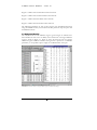
1
SINMAP UTAH STATE UNIVERSITY TERRATECH CONSULTING LTD. CANADIAN FOREST PRODUCTS LTD. C.N. GOODWIN FLUVIAL SYSTEM CONSULTING USER’S MANUAL SINMAP 2 A STABILITY INDEX APPROACH TO TERRAIN STABILITY HAZARD MAPPING Version for ArcGIS 9.x and Higher http://www.engineering.usu.edu/dtarb/sinmap.html Funded by: A STABILITY INDEX APPROACH TO TERRAIN STABILITY HAZARD MAPPING SINMAP User’s Manual August 2005 Authored by: R.T. Pack, Utah State University, formerly of Terratech Consulting Ltd. D.G. Tarboton, Utah State University C.N. Goodwin, C.N. Goodwin Fluvial System Consulting Ajay Prasad, Utah State University Supported by: Canadian Forest Products Ltd. Funded by: Forest Renewal B.C. U.S. Forest Service, Rocky Mountain Research Station http://www.engineering.usu.edu/dtarb/sinmap.html S I N M A P U S E R ’ S M A N U A L – P A R T I The Authors Robert T. Pack, Research Associate Professor of Civil and Environmental Engineering, Utah State University, Logan, Utah. David G. Tarboton, Professor of Civil and Environmental Engineering, Utah State University, Logan, Utah. Craig N. Goodwin, Principal, C.N. Goodwin Fluvial System Consulting, Logan, Utah. Ajay Prasad, Graduate Research Assistant, Civil and Environmental Engineering, Utah State University Disclaimers Although care has been taken in developing and testing SINMAP, errors and inadequacies may still occur, particularly in new applications. A user must therefore make the final evaluation as to the usefulness of SINMAP for his/her application. SINMAP is a tool to be used by investigators who have some knowledge and experience concerning landslide behavior. It requires engineering judgment and common sense in developing input parameters and interpretation of the results. In making these judgments the user should understand the concepts and limitations of the SINMAP theory presented in this document. This understanding should include a comprehension of the geomorphic processes which the program is attempting to model and the model’s limitations. Finally, the user should be aware of the accuracy limitations of the DEM, soil, and hydrologic data used as input for these analyses. The authors of SINMAP assume no liability or responsibility for the use of SINMAP, the interpretation of SINMAP results, or the consequences of management decisions that are based upon SINMAP. In no event shall the authors be liable for any damages whatsoever arising out of the use, or attempts to use SINMAP. Acknowledgements The original ArcView SINMAP was developed between Terratech Consulting Ltd, Utah State University and C.N. Goodwin Fluvial System Consulting. with the support of Forest Renewal British Columbia, in collaboration with Canadian Forest Products Ltd., Vancouver, British Columbia. It relies heavily on the coupling of steady state topographic hydrologic models with the infinite plane slope stability model, an approach pioneered by Bill Dietrich and David Montgomery. We acknowledge discussions and assistance from them. The ArcGIS version of SINMAP 2.0 was developed with support from the Rocky Mountain Research Station, Forest Service, U.S. Department of Agriculture under joint venture agreement number 03-jv-11222014-050. The views and conclusions expressed i S I N M A P U S E R ’ S M A N U A L – P A R T I are those of the authors and should not be interpreted as representing official policies of any Government or supporting agency. The digital elevation model methodology and algorithms have been developed by David Tarboton over several years with support from a variety of sources, but notably the National Science Foundation grant EAR-9318977 for the development of the D∞, flow directions approach. Distribution Copyright (C) 2005 David Tarboton, Utah State University This program is free software; you can redistribute it and/or modify it under the terms of the GNU General Public License version 2, 1991 as published by the Free Software Foundation. SINMAP is distributed from http://www.engineering.usu.edu/dtarb/sinmap.html This program is distributed in the hope that it will be useful, but WITHOUT ANY WARRANTY; without even the implied warranty of MERCHANTABILITY or FITNESS FOR A PARTICULAR PURPOSE. See the GNU General Public License for more details. A copy of the full GNU General Public License is included in the file gpl.html with the source code. This is also available at: http://www.gnu.org/copyleft/gpl.html or from: The Free Software Foundation, Inc., 59 Temple Place - Suite 330, Boston, MA 02111-1307, USA. If you wish to use or incorporate this program (or parts of it) into other software that does not meet the GNU General Public License conditions contact the author to request permission. Versions This release is Version 2.0, the second major release. The principle purpose of this release is the conversion for use with ArcGIS in place of ArcView 3.x. The original Version 1 release of SINMAP for ArcView 3.x is still available from http://www.engineering.usu.edu/dtarb/SINMAP1.htm ii S I N M A P U S E R ’ S M A N U A L – P A R T I Support There is no formal ongoing support for this freely distributed open source software. However, we are interested in feedback. If you find errors, have suggestions, or are interested in any later versions contact: Robert T Pack Utah State University 4110 Old Main Hill Logan, UT 84322-4110 USA email: [email protected] David G. Tarboton Utah State University 4110 Old Main Hill Logan, UT 84322-4110 USA http://www.engineering.usu.edu/dtarb/ email: [email protected] iii S I N M A P U S E R ’ S M A N U A L – P A R T I Summary SINMAP 2.0 (Stability Index MAPping) is an ArcGIS 9.0 plug-in that implements the computation and mapping of a slope stability index based upon geographic information, primarily digital elevation data. This report describes the theoretical basis for the calculation of the stability index, describes the implementation, presents several case studies and describes use of the accompanying software. SINMAP has its theoretical basis in the infinite plane slope stability model with wetness (pore pressures) obtained from a topographically based steady state model of hydrology. Digital elevation model (DEM) methods are used to obtain the necessary input information (slope and specific catchment area). Parameters are allowed to be uncertain following uniform distributions between specified limits. These may be adjusted (and calibrated) for geographic “calibration regions” based upon soil, vegetation or geologic data. The methodology includes an interactive visual calibration that adjusts parameters while referring to observed landslides. The calibration involves adjustment of parameters so that the stability map “captures” a high proportion of observed landslides in regions with low stability index, while minimizing the extent of low stability regions and consequent alienation of terrain to regions where landslides have not been observed. This calibration is done while simultaneously referring to the stability index map, a specific catchment area and slope plot (of landslide and non landslide points) where lines distinguish the zones categorized into the different stability classes and a table giving summary statistics. The current implementation of SINMAP 2.0 is a plug-in to the ArcGIS ArcMap geographic information system (GIS) from Environmental Systems Research Institute, Inc. (ESRI). This utilizes ArcMap for its standard GIS functionality such as the input and organization of data and the presentation and output of results. SINMAP is grid based, requiring ArcGIS version 9.0 or higher. iv S I N M A P U S E R ’ S M A N U A L – P A R T I Table of Contents THE AUTHORS ............................................................................................................................ I DISCLAIMERS ............................................................................................................................. I ACKNOWLEDGEMENTS ............................................................................................................... I DISTRIBUTION ........................................................................................................................... II VERSIONS.................................................................................................................................. II SUPPORT .................................................................................................................................. III SUMMARY ................................................................................................................................ IV SINMAP THEORY & IMPLEMENTATION........................................................................ 1 1.0 INTRODUCTION.............................................................................................................. 1 1.1 Purpose ........................................................................................................................... 1 1.2 Background ..................................................................................................................... 1 1.3 Applicability and Limitations .......................................................................................... 2 1.4 Required User Background............................................................................................. 3 2.0 SLOPE STABILITY THEORY.......................................................................................... 4 2.1 Overview ......................................................................................................................... 4 2.2 The Infinite Slope Stability Model ................................................................................... 5 2.3 Topographic Wetness Index ............................................................................................ 7 2.4 Stability Index Definition ................................................................................................ 9 3.0 DIGITAL ELEVATION MODEL METHODS................................................................ 11 3.1 Introduction................................................................................................................... 11 3.2 Pit Filling Corrections .................................................................................................. 11 3.3 Slopes and Flow Directions .......................................................................................... 11 3.4 Specific Catchment Area ............................................................................................... 13 3.5 SINMAP Stability Index and Wetness ........................................................................... 13 SINMAP SOFTWARE USER’S GUIDE .............................................................................. 14 1.0 INTRODUCTION............................................................................................................ 14 1.1 ArcMap document ......................................................................................................... 14 1.2 Slope-Area Plot Chart................................................................................................... 15 2.0 INSTALLATION ............................................................................................................. 15 2.1 Hardware and Software Requirements ......................................................................... 15 2.2 Installation Procedure .................................................................................................. 16 3.0 QUICK-START TUTORIAL ................................................................................................... 16 4.0 DETAILED TUTORIAL.................................................................................................. 17 4.1 Starting ArcMap and Loading SINMAP ....................................................................... 17 4.2 Establishing Model Parameters .................................................................................... 18 4.3 Importing and Selecting DEM Data.............................................................................. 19 4.4 Creating the Calibration Regions Grid Theme ............................................................. 21 4.5 Adding Landslides to the Map....................................................................................... 21 4.6 Preparatory Grid Processing........................................................................................ 22 4.7 Stability Analysis........................................................................................................... 23 4.8 Calibration Methods ..................................................................................................... 24 4.8.1 Adjusting parameters in the DEM view ................................................................................. 24 4.8.2 Adjusting parameters in the SA plot ...................................................................................... 25 4.9 Statistical Summary....................................................................................................... 26 4.10 The Rex Tool ............................................................................................................... 26 5.0 USEFUL TIPS .................................................................................................................. 27 5.1 Create a Calibration Region Outside Study Area. ........................................................ 27 v S I N M A P U S E R ’ S M A N U A L – P A R T I 5.2 Using an Existing Calibration Region Grid.................................................................. 27 6.0 DATA STRUCTURE REFERENCE ............................................................................... 28 6.1 Theme Name: Original DEM ........................................................................................ 28 6.2 Theme Name: Calibration Regions ............................................................................... 28 6.3 Theme Name: Landslides .............................................................................................. 29 6.4 Theme Name: Pit-filled DEM........................................................................................ 30 6.5 Theme Name: Flow Direction ....................................................................................... 30 6.6 Theme Name: Slope....................................................................................................... 30 6.7 Theme Name: Contributing Area .................................................................................. 31 6.8 Theme Name: Stability Index ........................................................................................ 31 6.9 Theme Name: Saturation............................................................................................... 32 6.10 Table Name: Attributes of Calregion (where Calregion is the name of a calibration region in the SA Plot table of contents)............................................................................... 33 7.0 MODIFYING SINMAP SOURCE CODE ....................................................................... 34 CASE STUDIES USING SINMAP ARCVIEW VERSION ................................................ 37 1.0 INTRODUCTION............................................................................................................ 37 2.0 KILPALA PILOT STUDY AREA ................................................................................... 37 2.1 Physiographic Setting ................................................................................................... 37 2.2 Input Data ..................................................................................................................... 38 2.3 Analytical Results.......................................................................................................... 39 2.4 Discussion ..................................................................................................................... 40 3.0 ROSE CREEK PILOT STUDY AREA ............................................................................ 41 3.1 Physiographic Setting ................................................................................................... 41 3.2 Input Data ..................................................................................................................... 41 3.3 Analytical Results.......................................................................................................... 42 3.4 Discussion ..................................................................................................................... 44 4.0 BURNT RIVER PILOT STUDY AREA .......................................................................... 45 4.1 Physiographic Setting ................................................................................................... 45 4.2 Input Data ..................................................................................................................... 45 4.3 Analytical Results.......................................................................................................... 47 4.4 Discussion ..................................................................................................................... 50 DETAILED DERIVATION OF STABILITY INDEX CONSIDERING UNCERTAINTY ................................................................................................................................................... 53 REFERENCES ........................................................................................................................ 63 vi S I N M A P U S E R ’ S M A N U A L – P A R T SINMAP THEORY & IMPLEMENTATION I I Part 1.0 INTRODUCTION 1.1 Purpose The purpose of the SINMAP (Stability INdex MAPping) theory implemented by this software is to provide an objective terrain stability mapping tool that can compliment subjective terrain stability mapping methods currently being practiced in the forest sector of British Columbia. The theory is also applicable to many other parts of the world that experience shallow translational landsliding. This manual provides comprehensive information required to use SINMAP theory in an appropriate manner. Part I introduces the fundamentals of the theory and the implementation of that theory. Part II provides a user’s guide to the software. Part III provides three case studies that demonstrate the utility of the theory. Detailed mathematical derivations of the theory are provided in Appendix 1. 1.2 Background There are many approaches to assessing slope stability and landslide hazards (Sidle et al., 1985; Dietrich et al., 1986; Montgomery and Dietrich, 1988; Montgomery and Dietrich, 1989; Carrera et al., 1991; Dietrich et al., 1992; Sidle, 1992; Dietrich et al., 1993; Montgomery and Dietrich, 1994; Wu and Sidle, 1995, Pack, 1995). The most widely used include (Montgomery and Dietrich, 1994): (1) field inspection using a check list to identify sites susceptible to landslides; (2) projection of future patterns of instability from analysis of landslide inventories; (3) multivariate analysis of factors characterizing observed sites of slope instability; (4) stability ranking based on criteria such as slope, lithology, land form, or geologic structure; and (5) failure probability analysis based on slope stability models with stochastic hydrologic simulations. Each of these is valuable for certain applications. None, however, take full advantage of the fact that debris flow source areas are, in general, strongly controlled by surface topography through shallow subsurface flow convergence, increased soil saturation, increased pore pressures and shear strength reduction (Montgomery and Dietrich, 1994). Recently, the availability of digital elevation model (DEM) data has prompted 1 S I N M A P U S E R ’ S M A N U A L – P A R T I the development of methods that take advantage of geographic information system (GIS) technology to quantify topographic attributes related to slope instability and landsliding. GIS technology permits patterns of instability to be resolved and mapped at the scale of the DEM. This relatively fine scale mapping which can pinpoint hazard areas has particular value for land management. Notable recent contributions are Montgomery and Dietrich (1994) and Wu and Sidle (1995). Montgomery and Dietrich (1994) combine a contour-based steady-state hydrologic model with the infinite slope stability model (simplified for cohesionless soils) to define slope stability classes based upon slope and specific catchment area. Wu and Sidle (1995) present a more elaborate model that couples dynamic modeling of the hydrology with the infinite slope stability model, in a more complex form, accounting for cohesion and varying root strength. The SINMAP approach is similar to that of Montgomery and Dietrich (1994) in that it combines steady-state hydrologic concepts with the infinite slope stability model. There are a few differences: (1) Grid-based rather than contour- based DEM methodology is used following the work of Tarboton (1997). This choice is primarily a matter of convenience. Grid-based DEMs are more common and their analysis is easier. (2) Cohesion is retained in the infinite slope stability model. This can be used to account for soil cohesion or root strength as modeled by Wu and Sidle (1995), or it may be set to 0 by a user who wants to consider cohesionless situations. (3) Parameter uncertainty is incorporated through the use of uniform probability distributions and lower and upper bounds on uncertain parameters. This is akin to the probabilistic approach of the Level I Stability Analysis (LISA) developed by Hammond et al. (1992) for the U.S. Forest Service. The SINMAP approach therefore reflects the real uncertainty associated with estimating parameters in terrain stability mapping. The results reduce to the deterministic case (equivalent to Montgomery and Dietrich, 1994) when upper and lower uncertainty bounds of the parameters are specified as equal and cohesion is set to zero. The range of uncertainty of the hydrologic wetness parameter may, in an approximate sense, substitute for the dynamic modeling over a range of storm events used by Wu and Sidle (1995), without requiring analysis and input of weather data. We believe that the complexity and additional computational burden of analyzing sequences of weather data is unwarranted. 1.3 Applicability and Limitations The SINMAP approach applies to shallow translational landsliding phenomena controlled by shallow groundwater flow convergence. It does not apply to deep-seated instability including deep earthflows and rotational slumps. It is not intended to be used in the absence of field information needed for calibration and is most profitably implemented in conjunction with other terrain stability mapping methods. The data required to implement the theory include soil and climate properties that can be highly variable in both space and time. The theory does not require numerically precise input and accepts ranges of values that represent this uncertainly. Stability indices output by the analysis should not be interpreted as numerically precise and are most appropriately interpreted in terms of relative hazard. 2 S I N M A P U S E R ’ S M A N U A L – P A R T I The methods implemented in the software rely on grid-based data structures rather than vector-based polygons. The accuracy of output is heavily reliant on the accuracy of the digital elevation model (DEM) data input. It is also heavily reliant on the accurate positioning of known landslide initiation zones. It is therefore important that as much effort a possible be put into obtaining accurate DEM and landslide inventory data. SINMAP can be used for forest planning and management, forest engineering, and other geohazard studies. Depending on the accuracy of the DEM data, landslide inventory data, and field checking used in the analysis, it has proven to be a useful tool for both reconnaissance-level mapping (1:20,000 scale) and detailed mapping (1:20,000 to 1:5,000 scale) as defined in the Forest Practices Code of British Columbia.1 Part III provides a brief summary of three case studies at various locations in British Columbia. 1.4 Required User Background The software was purposely implemented as a free Add-in toolbar to a popular GIS platform so as to be widely available. Though the software is simple to use, the theory that forms the basis of the software should be thoroughly understood in order to avoid misapplication. The user should therefore be experienced with applicable principals of geological engineering and engineering geoscience. Some familiarity with basic GIS concepts in general and ArcGIS ArcMap software particular is also required. See the Mapping and Assessing Terrain Stability Guidebook 1995, published by the B.C. Provincial Government. 1 3 S I N M A P U S E R ’ S M A N U A L – P A R T I 2.0 SLOPE STABILITY THEORY 2.1 Overview The SINMAP (Stability INdex MAPping) methodology is based upon the infinite slope stability model (e.g. Hammond et al., 1992; Montgomery and Dietrich, 1994) that balances the destabilizing components of gravity and the restoring components of friction and cohesion on a failure plane parallel to the ground surface with edge effects neglected. The pore pressure due to soil moisture reduces the effective normal stress, which through the friction angle is related to the shear strength. Pore water pressure is computed assuming a hydrologic steady state with depth of saturated soil computed sufficient to sustain a lateral discharge proportional to the specific catchment area (the upslope area per unit contour length). SINMAP derives its terrain stability classification from inputs of topographic slope and specific catchment area and from parameters quantifying material properties (such as strength) and climate (primarily a hydrologic wetness parameter). Each of these parameters is delineated on a numerical grid over the study area. The primary output of this modeling approach is a stability index, the numerical value of which is used to classify or categorize the terrain stability at each grid location in the study area. The topographic variables are automatically computed from digital elevation model (DEM) data. The other input parameters are recognized to be uncertain so are specified to SINMAP in terms of upper and lower bounds on the ranges they may take. The stability index (SI) is defined as the probability that a location is stable assuming uniform distributions of the parameters over these uncertainty ranges. This value ranges between 0 (most unstable) and 1 (least unstable). Where the most conservative (destabilizing) set of parameters in the model still results in stability, the stability index is defined as the factor of safety (ratio of stabilizing to destabilizing forces) at this location under the most conservative set of parameters. This yields a value greater than1. Terrain stability mapping practice in British Columbia (Province of British Columbia, 1995) requires that broad stability classes be identified and mapped, based upon relatively coarse information, to quickly identify regions where more detailed assessments are warranted. SINMAP is intended for this purpose. Table 1 gives an example of how broad stability classes may be defined in terms of the stability index (SI). The selection of breakpoints (1.5, 1.25, 1, 0.5, 0.0) is subjective, requiring judgement and interpretation in terms of the class definitions. In the example given we use the terms ‘stable’, ‘moderately stable’, and ‘quasi-stable’ to classify regions that according to the model should not fail with the most conservative parameters in the parameter ranges specified. SI for these cases is the factor of safety that gives a measure of the magnitude of destabilizing factors (e.g. increased wetness due to road drainage, local loading, or local enhancement of pore pressures due to soil pipe effects) required for instability. We use the terms ‘lower threshold’ and ‘upper threshold’ to characterize regions where, according to the parameter uncertainty ranges quantified by the model, the probability of instability is less than or greater than 50% respectively. External factors are not required to induce instability in these regions. Instability may 4 S I N M A P U S E R ’ S M A N U A L – P A R T I arise simply due to a combination of parameter values within the bounds with which uncertainty and variability can be quantified. We use the term ‘defended slope’ to characterize regions where, according to the model, the slope should be unstable for any parameters within the parameter ranges specified. Where such slopes occur in the field they are held in place by forces not represented in the model, or the model is inappropriate, as in the case of bedrock outcrops. In the sections that follow, we give the theory that forms the basis for SINMAP in terms of the infinite slope stability model and topographic wetness index. These components are combined with an accounting for parameter uncertainty to define the stability index SI. Technical details of the derivation are given in Appendix 1. TABLE 1. Stability Class Definitions Condition Class Predicted State SI > 1.5 1 Stable slope zone 1.5 > SI > 1.25 2 Moderately stable zone 1.25 > SI > 1.0 3 1.0 > SI > 0.5 4 0.5 > SI > 0.0 5 0.0 > SI 6 Quasi-stable slope zone Lower threshold slope zone Upper threshold slope zone Defended slope zone Parameter Range Range cannot model instability Range cannot model instability Range cannot model instability Pessimistic half of range required for instability Optimistic half of range required for stability Range cannot model stability Possible Influence of Factors Not Modeled Significant destabilizing factors are required for instability Moderate destabilizing factors are required for instability Minor destabilizing factors could lead to instability Destabilizing factors are not required for instability Stabilizing factors may be responsible for stability Stabilizing factors are required for stability 2.2 The Infinite Slope Stability Model The infinite slope stability model factor of safety (ratio of stabilizing to destabilizing forces) is given by (simplified for wet and dry density the same, from Hammond et al., 1992) FS = C r + C s + c os 2 θ[ρ s g (D − D w ) + (ρ s g - ρ w g) D w ] tan φ D ρ s gsinθ cos θ (1) where Cr is root cohesion [N/m2], Cs is soil cohesion [N/m2], θ is slope angle, ρs is wet soil density [kg/m3], ρw is the density of water [kg/m3], g is gravitational acceleration (9.81 m/s2), D the vertical soil depth [m], Dw the vertical height of the water table within the soil layer [m], and φ the internal friction angle of the soil [-]. The slope angle θ is the arc tangent of the slope, S, expressed as a decimal drop per unit horizontal distance. Figure 1 illustrates the geometry assumed in equation (1). 5 S I N M A P U S E R ’ S M A N U A L – P A R T I D h hw Dw θ = atan S FIGURE 1. Infinite slope stability model schematic. Our approach with the hydrologic model is to interpret the soil thickness as specified perpendicular to the slope, rather than soil depth measured vertically. Soil thickness, h [m], and depth are related as follows h = D cosθ (2) With this change FS reduces to FS = C + cos θ [1 − wr ] tan φ sin θ (3) where w = Dw/D = hw/h (4) is the relative wetness, C = (Cr + Cs)/(h ρs g) (5) the combined cohesion made dimensionless relative to the perpendicular soil thickness and r = ρw/ρs (6) the water to soil density ratio. Equation (3) is the dimensionless form of the infinite slope stability model that we use. This is convenient because cohesion (due to soil and root properties) is combined with the soil density and thickness into a dimensionless cohesion factor, C (equation 5). This may be thought of as the ratio of the cohesive strength relative to the weight of the soil, or the relative contribution to slope stability of the cohesive forces. Figure 2 illustrates this concept. The second term in the numerator of equation (3) quantifies 6 S I N M A P U S E R ’ S M A N U A L – P A R T I the contribution to stability due to the internal friction of the soil (as quantified by friction angle, φ, or friction coefficient, tanφ). This is reduced as wetness increases due to increasing pore pressures and consequent reductions in the normal force carried by the soil matrix. The sensitivity to this effect is controlled by the density ratio r (equation 6). h Combined Cohesion Cr+Cs [N/m2] (independent of soil thickness) h Soil weight h ρs g [N/m2] Dimensionless cohesion is the cohesive restoring force relative to soil weight [C = (Cr+Cs)/(h ρs g)], illustrated here on a vertical face to remove the effect of the normal and friction forces. FIGURE 2. Illustration of dimensionless cohesion factor concept. Practically, the model works by computing slope and wetness at each grid point, but assuming other parameters are constant (or have constant probability distributions) over larger areas. With the form of equation (3) this amounts to implicitly assuming that the soil thickness (perpendicular to the slope) is constant. 2.3 Topographic Wetness Index The emergence of the parameter specific catchment area, ‘a’, defined as upslope area per unit contour length [m2/m](see Figure 3) has been one of the landmark developments in recent hydrology, due to Beven and Kirkby (1979). It is tied closely to recent hydrologic models that represent runoff generation by the saturation from below mechanism (TOPMODEL Beven and Kirkby, 1979; O'Loughlin, 1986; TOPOG Moore et al., 1988; Moore and Grayson, 1991; and THALES Grayson et al., 1992a; and Grayson et al., 1992b). These developments follow the field observations that higher soil moisture or areas of surface saturation tend to occur in convergent hollow areas. It has also been reported that landslides most commonly originate in areas of topographic convergence (Montgomery and Dietrich, 1994). Following TOPMODEL (and other similar topographically based wetness index models) we make the following assumptions: 7 S I N M A P U S E R ’ S M A N U A L – P A R T I (1) Shallow lateral subsurface flow follows topographic gradients. This implies that the contributing area to flow at any point is given by the specific catchment area defined from the surface topography (Figure 3). (2) Lateral discharge at each point is in equilibrium with a steady state recharge R [m/hr]. (3) The capacity for lateral flux at each point is T sinθ, where T is the soil transmissivity [m2/hr], i.e. hydraulic conductivity [m/hr] times soil thickness, h [m]. Assumptions (1) and (2) together imply that lateral discharge q, depth integrated per unit contour length [m2/hr], is q=Ra (7) Assumption (3) differs from a common TOPMODEL (Beven and Kirkby, 1979) assumption in that we have not assumed hydraulic conductivity decreasing with S p e c ific C a tc h m e nt A re a a = A /b U n it c o nto u r le ng th b C o ntribu t ing a re a A FIGURE 3. Definition of Specific Catchment Area depth. Instead, we assume uniform conductivity of a soil mantle overlying relatively impermeable bedrock. In addition, we use sinθ rather than tanθ. This is more correct because the flow distance is actually along the slope. The difference between tan and sin, which is insignificant for small angles, matters for the steep slopes that give rise to landslides. Now with assumption (3) the relative wetness is Ra w = Min ,1 T sin θ (8) The relative wetness has an upper bound of 1 with any excess assumed to form overland flow. As illustrated in Figure 1, the relative wetness defines the relative depth of the perched water table within the soil layer. The ratio R/T in (8), which has units of [m-1], quantifies the relative wetness in terms of assumed steady state recharge relative 8 S I N M A P U S E R ’ S M A N U A L – P A R T I to the soil’s capacity for lateral drainage of water. Although the term ‘steady state’ is used with lateral flux approximated using equation (7) the quantity R is not a long term (e.g. annual) average of recharge. Rather it is the effective recharge for a critical period of wet weather likely to trigger landslides. The ratio R/T, which we treat as a single parameter, therefore combines both climate and hydrogeological factors. The quantity (T/R)sinθ [m] may be thought of as the length of hillslope (planar, not convergent) required to develop saturation in the critical wet period being considered. This concept may be useful for establishing field estimates of R/T through the field identification of the limits of surface saturation. 2.4 Stability Index Definition To define the stability index, the wetness index from equation (8) is incorporated into the dimensionless factor of safety, equation (3), which becomes R a C + cos θ [1 − min ,1r ] tan φ T sin θ FS = sin θ (9) The variables a and θ are from the topography with C, tanφ, r and R/T parameters. We treat the density ratio r as essentially constant (with a value of 0.5) but allow uncertainty in the other three quantities through the specification of lower and upper bounds. Formally these bounds define uniform probability distributions over which these quantities are assumed to vary at random. Denote R/T = x, tan φ = t, and the uniform distributions with lower and upper bounds as C ~ U(C1, C2) x ~ U(x1, x2) (10) t ~ U(t1, t2) The smallest C and t, (i.e. C1 and t1) together with the largest x (i.e. x2) defines the worst case (most conservative) scenario under this assumed uncertainty (variability) in the parameters. Areas where under this worst case scenario FS is greater than 1 are in terms of this model, unconditionally stable and we define a , 1 r ]t1 C1 + cos θ [1 − min x 2 sin θ SI = FS min = sin θ (11) For areas where the minimum factor of safety is less than 1, there is a possibility (probability) of failure. This is a spatial probability due to the uncertainty (spatial variability) in C, tanφ and T. This probability does have a temporal element in that R characterizes a wetness that may vary with time. Therefore the uncertainty in x 9 S I N M A P U S E R ’ S M A N U A L – P A R T I combines both spatial and temporal probabilities. In these regions (with FSmin < 1) we define SI = Prob(FS > 1) (12) over the distributions of C, x, and t (Equations, 10). The best case scenario is when C=C2, x=x1, and t=t2, which leads to a C 2 + cos θ [1 − min x1 , 1 r ]t 2 sin θ FSmax = sin θ (13) In the case that FSmax < 1, then SI = Prob(FS > 1) = 0 (14) Regions with SI > 1 (FSmin > 1), 0 < SI < 1 and SI = 0 (FSmax < 1) are illustrated in Figure 4 in a space defined in terms of slope (tanθ) and specific catchment area. This provides a useful visualization medium for understanding this approach. Appendix 1 derives the equations for computing these probabilities and drawing the lines on Figure 4. Saturated 5000 FSmax = 1 FSmin = 1.5 FSmin = 1.2 Possibly Saturated Higher than average pot. instability 0.5 > SI > 0 500 Area FSmin = 1.0 Unstable, SI = 0 Lower than average Unsaturated pot. instability 100 1 > SI > 0.5 50 SI = minimum 10 safety factors 0.0 0.5 1.0 1.5 Slope FIGURE 4. Stability Index defined in Area-Slope space. 10 2.0 S I N M A P U S E R ’ S M A N U A L – P A R T I 3.0 DIGITAL ELEVATION MODEL METHODS 3.1 Introduction The data storage structures available to digitally encode topography comprise: (1) Grid Digital Elevation Models (DEMs); (2) Triangulated Irregular Networks (TINs); and (3) contour based storage structures. Grid DEMs consist of a matrix data structure with the topographic elevation of each pixel stored in a matrix node. TINs store the X-Y location as well as elevation at irregularly spaced nodes. Contour based data structures store vector data along contour lines. Slope and specific catchment area can be computed in each of these frameworks and therefore the theory described above could be implemented in any of these frameworks. Within SINMAP, grid DEMs were selected for use primarily due to their simplicity and compatibility with Geographic Information System functionality, as well as the ready availability of data and prior experience with their use. The grid DEM processing routines used are based upon methods described by O'Callaghan and Mark (1984), Marks et al. (1984), Band (1986), Jenson and Domingue (1988), Tarboton (1989), Tarboton (1997) and Garbrecht and Martz (1997). There are 4 steps involved: (1) Pit filling corrections, (2) Computation of slopes and flow directions; (3) Computation of specific catchment area and (4) Computation of the SINMAP stability index. 3.2 Pit Filling Corrections Pits in digital elevation data are defined as grid elements or sets of grid elements surrounded by higher terrain that, in terms of the DEM, do not drain. These are rare in natural topography and generally assumed to be artifacts arising due to the discrete nature and data errors in the preparation of the DEM. They are eliminated here using a ‘flooding’ approach. This raises the elevation of each pit grid cell within the DEM to the elevation of the lowest pour point on the perimeter of the pit (e.g. Jenson and Domingue, 1988). 3.3 Slopes and Flow Directions The earliest and simplest method for specifying flow directions is to assign flow from each grid cell to one of its eight neighbors, either adjacent or diagonally, in the direction with steepest downward slope. This method, designated D8 (8 flow directions), was introduced by O'Callaghan and Mark (1984) and has been widely used. The D8 approach has disadvantages arising from the discretization of flow into only one of eight possible directions, separated by 45° (e.g. Fairfield and Leymarie, 1991; Quinn et al., 1991; Costa-Cabral and Burges, 1994; Tarboton, 1997). These have motivated the development of other methods comprising multiple flow direction methods (Quinn et al., 1991; Tarboton, 1997), random direction methods (Fairfield and Leymarie, 1991) and grid flow tube methods (Costa-Cabral and Burges, 1994). Tarboton (1997) discusses the relative merits of these. SINMAP uses the D∞ method, the multiple flow direction method developed by Tarboton (1997). 11 S I N M A P U S E R ’ S M A N U A L – P A R T I In this method, the flow direction angle measured counter clockwise from east is represented as a continuous quantity between 0 and 2π. This angle is determined as the direction of the steepest downward slope on the eight triangular facets formed in a 3 x 3 grid cell window centered on the grid cell of interest as illustrated in Figure 5. A block-centered representation is used with each elevation value taken to represent the elevation of the center of the corresponding grid cell. Eight planar triangular facets are formed between each grid cell and its eight neighbors. Each of these has a downslope vector which when drawn outwards from the center may be at an angle that lies within or outside the 45o (π/4 radian) angle range of the facet at the center point. If the slope vector angle is within the facet angle, it represents the steepest flow direction on that facet. If the slope vector angle is outside a facet, the steepest flow direction associated with that facet is taken along the steepest edge. The slope and flow direction associated with the grid cell is taken as the magnitude and direction of the steepest downslope vector from all eight facets. This is implemented using equations given in Tarboton (1997). Proportion flowing to neighboring grid cell 4 is α1/(α1+α2) 4 Steepest direction downslope Proportion flowing to neighboring grid cell 3 is α2/(α1+α2) 3 α2 α1 1 5 6 2 7 Flow direction measured as counter-clockwise angle from east. 8 FIGURE 5. Flow direction defined as steepest downward slope on planar triangular facets on a block centered grid. In the case where no slope vectors are positive (downslope), the flow direction is set using the method of Garbrecht and Martz (1997) for the determination of flow across flat areas. This makes flat areas drain away from high ground and towards low ground. These procedures have minimal impact when used in SINMAP because flat areas are always unconditionally stable, but are included for completeness and compatibility with other hydrologic uses, and to avoid data gaps in the maps produced. 12 S I N M A P U S E R ’ S M A N U A L – P A R T I 3.4 Specific Catchment Area Upslope area (counted in terms of the number of grid cells) is calculated using a recursive procedure that is an extension of the very efficient recursive algorithm for single directions (Mark, 1988). The upslope area of each grid cell is taken as its own area (one) plus the area from upslope neighbors that have some fraction draining to it. The flow from each cell either all drains to one neighbor, if the angle falls along a cardinal (0, π/2, π, 3 π /2) or diagonal (π /4, 3 π /4, 5 π /4, 7 π /4) direction, or is on an angle falling between the direct angle to two adjacent neighbors. In the latter case the flow is proportioned between these two neighbor pixels according to how close the flow direction angle is to the direct angle to those pixels, as illustrated in Figure 5. Specific catchment area, a, is then upslope area per unit contour length, taken here as the number of cells times grid cell size (cell area divided by cell size). This assumes that grid cell size is the effective contour length, b, in the definition of specific catchment area (Figure 3) and does not distinguish any difference in contour length dependent upon the flow direction. 3.5 SINMAP Stability Index and Wetness Computation of the SINMAP stability index is simply a grid cell by grid cell evaluation of the equations in Appendix 1. Wetness computed from equation (8) is also returned as a by-product of the stability index calculations. 13 S I N M A P U S E R ’ S M A N U A L – P A R T I I I SINMAP Software User’s Guide II Part 1.0 INTRODUCTION I C O N K E Y Valuable information Keyboard input ∅ Warning The SINMAP theory presented in Part I of this report is implemented in computerized form. The theory has been incorporated into a library of computer routines that can be called to perform computational tasks including calculating stability index and saturation (wetness index). Additionally, library routines are also available to perform many basic tasks of manipulating digital elevation model (DEM) grid data including topographic pit filling, calculating slopes, determining flow directions, and defining the area draining to a specific point. These various routines are written in the C programming language and are contained within a dynamic link library (DLL) file. Because of the spatial or geographic nature of SINMAP analyses, on-screen or printed maps are required for interpreting some computational output. Rather than create custom routines to provide standard geographic analysis abilities, SINMAP utilizes offthe-shelf geographic information system (GIS) software to handle these tasks. SINMAP 2.0 uses the ArcGIS 9.0 from Environmental Systems Research Institute, Inc. (ESRI). To use SINMAP, you must have ArcGIS version 9.0 or higher and be using a Microsoft Windows operating system. SINMAP adds its capabilities to ArcGIS 9.0 through the loading of a custom ArcGIS 9.0 plugin. ArcGIS 9.0 allows encapsulation of customizations through Microsoft Component Object Model (COM) Dynamic Link Library (dll) files. SINMAP is comprised of two dll's, 'agSINMAP.dll' and 'SinmapCOMDLL.dll'. The first provides links between ArcGIS 9.0 and the library of computational routines that are in the second. SINMAP tasks are undertaken in an ArcGIS 9.0 ArcMap session. 1.1 ArcMap document The final output of most SINMAP studies will be maps that can be used to define areas of potential terrain instability. Within ArcGIS 9.0, a map is displayed on-screen in an ArcMap document. Most tasks are conducted from SINMAP’s ArcMap toolbar. These tasks involve the creation, use, and display of geographic grid data. A DEM grid 14 S I N M A P U S E R ’ S M A N U A L – P A R T I I I provides the topographic basis for a SINMAP study, and a grid of soils and hydrologic terrain parameters classified into ‘calibration regions’ provides non-topographic parameter information required for the study. Tasks using either one or both of these grids create another six (6) grids that represent the geographic distribution of topography without pits, land slope, flow direction, contributing area, saturation, and stability index. In addition to grid data, point data for landslides are required if the user wants to compare locations of predicted instability with areas of actual instability. These geographic data sets are added to the DEM map document as themes − grid themes for the grid data and as a point theme for landslide data. A full SINMAP study will therefore use and/or create a total of nine (9) GIS themes. 1.2 Slope-Area Plot Chart In addition to the geographic display of study data in a DEM map document, SINMAP also generates a slope-area chart (graph) of study area data to aid in data interpretation and parameter calibration. The slope-area plot, illustrated and defined in Figure 4 is generated by SINMAP routines. Examples of SINMAP slope-area plots, termed ‘SA Plot’ herein, are illustrated in Part III, Figures 6, 9, 13, 16, and 17. Plotted on the SA Plot are four types of information: 1. Normal cell data. Specific catchment area versus slope is plotted for a sampling of grid cell points across the study area that does not have landslides. 2. Landslide cell data. Landslides are plotted based upon the slope and specific catchment area values of the cell in which each landslide point lies. 3. Stability index region lines. These five (5) lines provide boundaries for regions within slope-specific catchment area space that have similar potential for stability or instability. 4. Saturation region lines. These three (3) lines provide boundaries for regions within slope-specific catchment area space that have similar wetness potential. 2.0 INSTALLATION 2.1 Hardware and Software Requirements The current version of SINMAP has been tested on Windows XP and Windows 2000 operating systems. You need ESRI's ArcGIS 9.0 for Windows software to use SINMAP 2.0. You will need enough computer memory, usually the more the better. In this version of SINMAP, we dump the grids into large arrays in memory so as to keep disk input/output down and speed up. If you do not have enough memory to fully contain all the grids, Windows will swap memory pages out to disk. This can slow things down dramatically as a lot of swapping and thrashing can occur. If you plan on using extremely large grid study areas, try to close out all other processes to free up as much memory as possible. Check Task Manager to see how much memory you 15 S I N M A P U S E R ’ S M A N U A L – P A R T I I I actually have available. Table 2 lists the amount of memory your computer needs to run SINMAP with a particular DEM grid size and maintain all operations in memory. The values are approximate only, for the exact value depends on the specifics of your system configuration and the complexity (number of pits and flats) of the DEM being processed. Table 2. Approximate amount of memory your computer needs to run SINMAP on a particular size DEM grid. DEM Grid Size (cells) 10,000 (100x100) 250,000 (500x500) 1,000,000 (1,000x1,000) 6,250,000 (2,500x2,500) Memory Required (Megabytes) 0.16 4 16 100 2.2 Installation Procedure SINMAP is distributed using an installation package that may be downloaded from the SINMAP website. Execute the installation setup file to install the necessary libraries and components. The setup will create SINMAP folder inside the Program Files folder. The setup will place agSINMAP.dll and sinmapCOMDLL.dll inside the SINMAP folder. Other files included with the installation are: SINMAP.pdf - copy of this user’s manual in Adobe Acrobat format example.zip This is a zip file containing sample data comprising: sample.asc small test ASCII file of DEM data samplels.shp ArcGIS shape files for point landslide sample data samplels.shx samplels.dbf } Source code can be downloaded from the SINMAP website and modifying the source code is explained in section 8. 3.0 Quick-start tutorial This section provides a quick introduction to the steps required to undertake a SINMAP analysis. Each of these procedures is explained in more detail in Section 4. Sample data files are provided for use with the tutorial. The file sample.asc is a small ASCII file of DEM data, and the files samplels.shp, samplels.shx, and samplels.dbf are a point shapefile coverage of landslides. These files should be copied to a folder where you want the SINMAP output files to be created. 16 S I N M A P U S E R ’ S M A N U A L – P A R T I I I 1. Start up ArcMap. Click on tools > Customize > Add from file and select the file c:\program files\SINMAP\agSINMAP.dll. In the Customize dialog box, select the check box next to SINMAP. The SINMAP Toolbar should appear. 2. Open ArcToolbox. Open the tool Conversion Tools > To Raster > ASCII to Raster. On the ASCII to Grid dialog choose the file sample.asc, as input file and name the output grid ‘sample’, and choose Grid type as Float. 3. The SINMAP toolbar loaded as step 1 has three menus; Initialization, Grid Processing, and Stability Analysis. From the Initialization menu, choose ‘Select DEM Grid for Analysis’, and then navigate to and select the ‘sample’ grid. 4. From the Initialization menu choose ‘Make Single Calibration Region Theme.’ Accept the default values for the calibration parameters. 5. From the Initialization menu choose ‘Select Landslide Point Theme’. Select the file samplels.shp in the file navigator box. 6. Under Grid Processing menu, select ‘Compute All Steps’ to create the pit-filled DEM, slope, flow direction, and specific catchment area grid themes. 7. Under Stability Analysis menu, select ‘Compute All Steps’ to create the stability index and saturation grid themes and to create the SA Plot. 8. In the newly created SA Plot, ‘Region 1 Points’ will be checked and points visible in the plot. 9. From the list box on the left of the SA Plot choose ‘Region 1 Lines’ to overlay the data points with the SINMAP theory boundary lines. 10. To view a statistical summary of the data, click Statistics button on the SA-Plot dialog. You have completed a SINMAP study. 4.0 DETAILED TUTORIAL 4.1 Starting ArcMap and Loading SINMAP Start ArcMap within Windows using any of the methods available, like double clicking on an ICON, or file with extension ‘.mxd’, or by selecting it within Start/Programs in Windows. From the Project window Tool menu, select the Customize... menu item. Then, check the check box next to SINMAP. For SINMAP to operate, it must be loaded into ArcMap. To add the SINMAP toolbar to ArcMap click on tools/customize. At the Customize dialog click on add 17 S I N M A P U S E R ’ S M A N U A L – P A R T I I I from file.... Browse to c:\program files\SINMAP\agSINMAP.dll then click Open. Click OK to added objects. The entry "Stability Index MAPping (SINMAP)" should appear under Toolbars. Check this (if not already checked) and close the customize dialog. The SINMAP toolbar should now be present in the ArcMap environment. If it does not appear the first time, close and reopen ArcMap. Menu items in this toolbar provide SINMAP’s functionality. The SINMAP toolbar has three main menu items and 17 submenu items that provide for selecting, creating, and modifying the data used in a terrain stability mapping study. These menu items are divided into three (3) groups on the menu, with groups distinguished by main menus on the tool bar. A study is undertaken by selecting menu items at the top-left of the menu and working downward-right within the tool bar. Menu items are grayed (disabled) when data are not available for the particular program operation associated with that item. 4.2 Establishing Model Parameters The first two menu items on the SINMAP tool bar provide access to dialog boxes for establishing various program parameters. Default values are provided for all parameters, so it is not required for a user to input parameter values. However, calibration region parameters will need to be modified by the user to provide realistic values for the user’s study area. The user may come back and modify these values at a later time while conducting the study. Other means are also provided within the program (described later) for more easily modifying most of these values ‘on the fly’ during the calibration process. From the SINMAP Initialization menu, choose the Set Defaults menu item. Selecting the ‘Set Defaults’ menu item displays a dialog box allowing input of several fundamental physical parameter values and modification of a SA Plot display setting. Values changeable in this dialog box are: Gravity constant. Default value: 9.81m/s2. Water density. Default value: 1000 kg/m3. Number of points in a SA Plot. Default value: 2000. SA Plot Lower wetness index. Default value: 10 %. Two check boxes give option for the grid processing operation. The first check box enables or disables the checks for edge contamination while calculating contributing area. The second check box enables or disables the prompt before over writing existing files (grids). The SA Plot displays all study area landslide points on a slope-area plot, but only a limited number of grid cells without landslides are normally displayed in order to speed 18 S I N M A P U S E R ’ S M A N U A L – P A R T I I I computations and make a less cumbersome graph. (Remember, a 500 by 500 DEM grid has 250,000 cells, which is a lot of points to display on an x-y graph.) The number of cells displayed in the plot is approximate. From the Initialization menu on the SINMAP tool bar, choose the Set Calibration Parameters menu item. Selecting the ‘Set Calibration Parameters’ menu item displays a dialog box that allows input of several soil parameters and modification of a SA Plot display setting. Values changeable in the calibration parameter input dialog box are: T/R (lower bound). Default value: 2000 m. This is the lower bounding value for the ratio of transmissivity to the effective recharge rate. T/R (upper bound). Default value: 3000 m. This is the upper bounding value for the ratio of transmissivity to the effective recharge rate. Dimensionless Cohesion (lower bound). Default value: 0.0. This is the lower bounding value that takes into account both root and soil cohesion. Dimensionless Cohesion (upper bound). Default value: 0.25. This is the upper bounding value that takes into account both root and soil cohesion. Phi [degrees] (lower bound). Default value: 30o. This is the lower bounding value of the soil friction angle. Phi [degrees] (upper bound). Default value: 45o. This is the upper bounding value of the soil friction angle. Soil Density. Default value: 2000 kg/m3. 4.3 Importing and Selecting DEM Data Using a DEM in SINMAP requires two steps: 1) creating a grid of DEM data in the ArcGIS raster grid format, and 2) selecting that grid for the SINMAP analysis. Creating an ArcGIS raster grid of DEM data is generally undertaken using one of two general methods: Obtaining DEM grid data files that can be directly imported to ArcGIS ArcMap, or Generating an ArcGIS DEM grid file from a point, contour, or triangulated irregular network data set using ArcToolBox. There are a variety of ways to undertake either of these grid creation strategies. One method is to create the data set in the ASCII file format that can be converted to ArcGIS Raster grid format by ArcGIS. The sample data file sample.asc illustrates this file format. 19 S I N M A P U S E R ’ S M A N U A L – P A R T I I I Open the ArcToolbox window. Open the tool Conversion Tools > To Raster > ASCII to Raster. On the ASCII to Grid dialog choose the file sample.asc, as input file and name the output grid ‘sample’. Choose Grid type as Float. ∅ Alternatively, ARC/Info routines for creating grids from point, TIN, or contour data can be used by users having access to these tools. In particular the TOPOGRID software available in Arc/Info, for the generation of grid DEM’s from contour or point data, while respecting the fluvial drainage morphology of natural topography is recommended. The ArcGIS Spatial Analyst extension also allows creation of grids from a point theme data sets using the following steps. Activate a point theme containing elevation points. From the Analysis menu, choose Interpolate Surface. Provide grid values in the Output Grid Specification dialog box and choose a surface interpolation method in the Interpolate Surface dialog box. However, we caution users that, in our experience, the interpolation methods used by Spatial Analyst are often not well suited to certain types of topography. We have found TOPOGRID and TIN-based interpolation methods, to be preferable. After the DEM grid is created, the next step is to select the grid for SINMAP analysis. From the Initialization menu on the SINMAP toolbar, choose Select DEM Grid for Analysis. ∅ Choosing the ‘Select DEM Grid for Analysis’ menu item will display a file selection dialog box. The user navigates through the drives and directories to locate the desired DEM grid and chooses OK. The selected DEM grid is added as a grid theme to the map document and is automatically renamed to ‘Original DEM’ in the table of contents. A Greens to Reds color scheme is used. This color scheme can be changed at any time without affecting the operation of SINMAP. SINMAP uses table of contents names to identify data sets so do not rename this theme or other themes added to the table of contents by SINMAP unless you want SINMAP to no longer recognize this file (such as you may do if you wish to recalculate or use a grid from somewhere else). The name of the selected DEM is used as the base name for all files created during the study. Therefore, if the selected DEM is named demname, then names of files or grid subdirectories created during the study would have names like demname.dbf and demnamefel. [Throughout the rest of this document, demname is used to represent the base name.] All of the files and subdirectories created by SINMAP during the study will be located in the folder SINMAPdata created in the folder containing the original DEM grid. It may be useful to create a specific folder for each study where input data files and SINMAP-generated files are stored. This is not a program requirement because the DEM base name identifies files associated with a study, but it is better housekeeping. 20 S I N M A P U S E R ’ S M A N U A L – P A R T I I I 4.4 Creating the Calibration Regions Grid Theme Calibration regions are areas within which single lower bound and upper bound calibration parameters values can represent T/R, dimensionless cohesion, and friction angle (phi). Soil density (rho) may also be specified for each calibration region, although lower and upper bounds are not used. Regions are commonly defined using soils, geologic, vegetation, and land use mapping to identify areas having consistent calibration parameters. For a SINMAP analysis to provide a realistic assessment of terrain stability, the user should understand SINMAP theory and the factors causing the spatial distribution of the calibration parameters. There are three menu items that may be chosen to create a calibration regions grid. The choice is dependent upon the type of geographic data available and the level of analysis sought. Creation of a calibration grid creates the grid demnamecal in the SINMAPdata folder, and adds the grid theme ‘Calibration Regions’ to the map. Also, a comma separated variable file table of calibration parameters named ‘demnamecalp.csv’ is created in the SINMAPdata folder. Option 1: From the SINMAP Initialization menu, choose Make Single Calibration Region Theme. This method for creating a calibration regions grid theme and an associated grid produces a single calibration region for the entire study area. The region is called ‘Region 1’, and the parameter data table for it is populated with default values. Option 2: From the SINMAP Initialization menu, choose Create Multi-Region Calibration Theme. This method can be used if you have a polygon coverage (shapefile) or grid theme of calibration regions. Selection of this menu item pops up a file navigation dialog box that allows you to pick a grid or polygon feature theme. After you select the theme, a dialog box listing field names in the selected coverage is presented. Pick the field containing the names of the calibration regions. A calibration regions grid is then created, with each region populated with default parameter values. Option 3: From the SINMAP Initialization menu, choose Use Existing Calibration Region Grid. This item will add any existing calibration regions grid in the study folder; otherwise it will show the Browse Dialog allowing user to select the calibration regions grid. If you have previously created a calibration regions grid and wish to continue using it, this is the selection to choose. 4.5 Adding Landslides to the Map A landslide point theme (coverage or shapefile) may be added to the SINMAP study to allow evaluation of conditions where landsliding has occurred. The data table (Ftab) for the landslide coverage (or shapefile) must have a numeric field called ‘Type’ that 21 S I N M A P U S E R ’ S M A N U A L – P A R T I I I identifies the type of landslide feature. Values for type must range from 1 to 4. If these several conditions are not met, then an error message will be issued specifying the problem. The landslides theme is added with legend descriptions of 'Type 1', 'Type 2', 'Type 3', and 'Type 4', if four distinct landslide types are identified in the data table. The user may then modify these legend names as desired. From the SINMAP Initialization menu, choose Select Landslide Point Theme. A file navigation dialog box is presented from which the landslide theme file can be selected. After the theme is added to the View, this menu item is grayed. 4.6 Preparatory Grid Processing A major part of a SINMAP study is the creation of several derivative grids from the DEM grid. These grids are derived solely from the DEM grid and require no other parameters for their construction. The processes for creating these several grids are initiated by selecting menu items in the second menu of the SINMAP toolbar. The grids and associated grid themes that are created by the grid processing steps are: • Pit-Filled DEM • Flow Direction • Slope • Contributing Area Option 1: From the SINMAP Grid Processing menu, choose Compute All Steps. The ‘Compute All Steps’ menu item becomes ungrayed and available for selection after a DEM grid is selected and added to the view. ‘Compute all steps’ sequentially executes routines for generating the pit-filled, slope, flow direction, and contributing area grids and adds these grids to the ArcMap. If any of the four grid files already exist, having been previously generated, a OK-Cancel dialog pops up if “Prompt before overwriting files that exists” is enabled in the Set defaults menu in the Initialization menu, asking if you wish to over write the existing grids. Answering OK will cause new grids to be created for map document grid themes. Option 2: From the SINMAP Grid Processing menu, choose each processing step separately by first choosing Pit-Filled DEM. This selection generates the pit-filled DEM grid and adds the grid theme ‘Pit-filled DEM’ to the map dpcument. The grid file generated will have the name demnamefel. If demnamefel exists, a Ok-Cancel dialog pops up if “Prompt before overwriting files that exists” is enabled in the Set defaults menu in the Initialization menu, asking if you wish to over write the existing grids. Answering Ok will cause new grids to be created for map grid themes. 22 S I N M A P U S E R ’ S M A N U A L – P A R T I I I From the SINMAP Grid Processing menu, choose Flow Direction and Slope as the next step. Choosing this selection causes generation of the flow direction and slope grids, with grid themes of the same names added to the ArcMap. The grid files generated will have the names demnameang (flow direction) and demnameslp (slope). If either of the grids exist, a Ok-Cancel dialog pops up if “Prompt before overwriting files that exisits” is enabled in the Set defaults dialog in the Initialization menu, asking if you wish to over write the existing grids. Answering Ok will delete existing grids and new grids are created and added to the ArcMap document . From the SINMAP Grid Processing menu, choose Contributing Area as the final step. This selection generates the contributing area grid and adds it to the ArcMap. The grid file generated will have the name demnamesca, where demname is the name of the original DEM grid. If demnamesca exists a Ok-Cancel dialog pops up if “Prompt before overwriting files that exisits” is enabled in the Set defaults menu in the Initialization menu, asking if you wish to over write the existing grids. Answering Ok will delete existing grids and new grids are created and added to the ArcMap document . 4.7 Stability Analysis SINMAP theory discussed in Part I of this document is implemented within the program with results displayed as saturation and stability index grid themes and the creation of an SA Plot. These results are generated using menu items in the Stability Analysis menu item group. Option 1: From the SINMAP Stability Analysis menu choose Compute All Steps. The ‘Compute All Steps’ menu item becomes ungrayed (enabled) after slope, contributing area, and calibration regions grid themes have been created and added to the ArcMap. The ‘Compute All Steps’ menu item sequentially executes routines for generating the Stability Index and Saturation grids, adds these grids to the ArcMap as grid themes, and creates the SA Plot. a Ok-Cancel dialog pops up if “Prompt before overwriting files that exisits” is enabled in the Set defaults menu in the Initialization menu, asking if you wish to over write the existing grids. Answering Ok will delete existing grids and new grids are created and added to the ArcMap document . Option 2: From the SINMAP Stability Analysis menu choose each processing step separately by first choosing Stability Index. This selection generates a grid with a stability index at each grid cell location. The grid file generated will have the name demnamesi. a Ok-Cancel dialog pops up if “Prompt before overwriting files that exisits” is enabled in the Set defaults menu in the Initialization menu, asking if you wish to over write the existing grids. Answering Ok will delete existing grids and new grids are created and added to the ArcMap document. This step also generates a saturation grid file (demnamesat). 23 S I N M A P U S E R ’ S M A N U A L – P A R T I I I From the SINMAP Stability Analysis menu, choose Saturation as the next step. This selection adds a Saturation grid theme to the ArcMap, using the saturation grid that was created in the previous step. From the SINMAP Stability Analysis menu, choose SA Plot as the final step. The SA Plot menu item creates a slope-area plot window. The advantage to creating the plot using this menu item in preference to the Compute All Steps selection is that the number of natural terrain points used for plotting may be specified. When the plot is created with the Compute All Steps selection, the default number of points (2,000) or the number of points previously established by the user is displayed on the plot. Selection of the SA Plot menu item allows an on-the-fly change to the number of points to be plotted in a dialog box. The number of points plotted is only approximate and does not include landslide points. Creating the SA Plot first creates the file demnamertp for random points, demnamelsf for landslide file, and demnamestat for SA statistics. First two text files are X-Y table of point index, region index, slope-area data and other attribute, landslide, and location data for each cell. The third text file is a table of stability analysis statistics for each region containing Area (km^2), percentage of Region, number of Landslides, percentage of Landslides, LS Density (#/km^2). Data from these files provide the basis for the SA Plot. The SA Plot is then created, named ‘SA Plot: Demname’, and resized along with the DEM map document so that both windows may be viewed at the same time. The SA Plot menu item becomes enabled after the calibration regions, slope, and contributing area grid themes are added to the ArcMap. In some situations, it may become necessary to create a rebuild SA Plot. For example, if new landslide data become available and are added as data points to the Landslides/Seeps theme, it is necessary to rebuild demnamertp, demnamelsf and demnamestat files with the added data points for these landslides. This is done by closing the SA plot window and adding the landslide points to the map and opening the SA plot again. 4.8 Calibration Methods 4.8.1 Adjusting parameters in the DEM view The bottom group on the SINMAP Stability Analysis menu has two items ‘Calibration Parameter Adjust’ and ‘Update Grids and Lines.’ These two menu items allow the user to change the values of soil parameters in the calibration regions table and then update the Stability Index and Saturation grids, and SA plot lines based upon these changes. 24 S I N M A P U S E R ’ S M A N U A L – P A R T I I I From the SINMAP Stability Analysis menu, choose Calibration Parameter Adjust. Choosing this selection activates the study’s calibration regions table making it available for the modification of calibration region parameters. After the editing of parameter values are completed and saved, the Stability Index and Saturation grid themes (which are dependent upon calibration region parameters) can be updated by clicking Update Grids menu in the Stability Analysis menu. Updating deletes the existing Stability Index grid and Saturation grid and recreates the grids using new calibration region parameter values. New grids are added as themes to the ArcMap document. If lines are visible on the SA plot they are also updated. Once the values are edited and saved the Statistics button on SA plot will be disabled. It is enabled once the SI and Sat grids are updated with new calibration parameter values. 4.8.2 Adjusting parameters in the SA plot The SA Plot has several features that allow parameters, updating of SA Plot stability index saturation and stability index themes. Viewing calibration regions is described in Section 4.10. clicking the buttons on the SA Plot window. modification of calibration region lines, and updating DEM maps of of landslide and cell statistics for These features may be accessed by Step 1: From the list box on the SA Plot window display Stability Equation Lines by selecting corresponding check box for the region. This list box acts as a toggle that makes the stability equation lines either visible or invisible. Stability lines for each region will be displayed in different colors. Parameters for the stability equations for each activated region theme are obtained from the study’s calibration region table. Step 2: From SA Plot window activate Adjust Calibration Parameters dialog by clicking the ‘Par Edit’ Button. The dialog box allows changes to be made to the calibration region parameters (T/R, cohesion, and phi) for the selected calibration region(s). After changes are made to the parameters and the OK button is clicked, the previous stability equation and saturation lines are removed (if they were visible) and a new set of lines based upon the revised parameters is displayed. A typical work flow sequence would be to iteratively modify calibration region parameters until the stability and saturation lines “fit” the data for a specific region. Parameters for each region can thereby be adjusted to eventually calibrate the whole study area. 25 S I N M A P U S E R ’ S M A N U A L – P A R T I I I Step 3: From either the SINMAP Stability Analysis menu choose Update Grids. This updates both the saturation and stability index grids, as described in Section 4.9.1 above. 4.9 Statistical Summary From either the SA Plot window click Statistics button. This item displays a table of summary statistics for each calibration region by stability class as shown in Table 3. TABLE 3. Example of statistical results of the SINMAP analysis. Moderately QuasiStable Stable Stable Area (km2) 41.8 9.8 14.4 % of Region 39.9 9.3 13.7 # of Slides 0 0 1 % of Slides 0.0 0.0 1.5 0.0 0.1 LS Density (#/km2) 0.0 See Table 1for a definition of stability classes. Lower Thresh 11.6 11.1 8 12.3 0.7 Upper Thresh 9.6 9.1 11 16.9 1.1 Defend 17.6 16.8 45 69.2 2.6 Total 104.8 100.0 65 100.0 0.6 The mouse or shift and arrow keys may be used to select data that can be copied (Control-C) or right click on the table and copy, and then pasted into another program. If this button is disabled, then the stability index grid has not been updated since calibration parameters have been adjusted. Select the ‘Update Grids’ menu item to update the grid and enable statistics calculation. 4.10 The Rex Tool When the SINMAP extension is loaded, a tool with a dog figure (Rex) is added to the right side of the tool bar. The Rex tool is available for selecting landslide points in either the SA Plot view or the DEM map and having the same landslide point highlighted in the other view. The Rex feature proves useful to the user who is attempting to understand the slope-area conditions that lead to the occurrence of a particular landslide. (You can visualize Rex as your trusty dog that sniffs out the appropriate landslide points.) For selecting a Landslide on the SA plot, move the mouse over landslide point and the mouse icon is changed to pan or hyperlink icon. A landslide is selected by moving the target cursor to a landslide symbol on the SA plot, and clicking the left mouse button. The selected landslide changes to the selection color (light blue is the ArcGIS default) on both the SA Plot and the DEM map. To select a landslide point on the map, click on Rex Icon and the mouse icon changes to concentric circle icon. Now select the landslide point on the map. The selected landslide and the landslide point on the SA plot will change to selection color. 26 S I N M A P U S E R ’ S M A N U A L – P A R T I I I 5.0 USEFUL TIPS 5.1 Create a Calibration Region Outside Study Area. SINMAP calibrations and statistics are based upon calibration regions. If you make a region that incorporates all areas on the DEM that are not part of the study area, then the remaining calibration and statistics can be based solely upon the study area. For example, if you were planning on having only one calibration region, then create two − one which is called something like Non-Project Area and the other called Project Area. This can be done by using an ownership or land management base map to create a polygon (or grid) theme with the attributes Non-Project Area and Project Area. This theme can then be used as the basis for creation of the Calibration Regions grid theme. The other grids and SA Plot can then be created in the usual manner. In the SA Plot, you can remove the theme called Non-Project Area if you wish. Additionally, after you have created all the other grids, you can go back and use the various Spatial Analyst routines (Map Query, Raster Calculator, etc.) to provide statistics and summaries solely for the project area. 5.2 Using an Existing Calibration Region Grid If you already have a grid of calibration regions that you would like to use, you can incorporate it directly in the analysis. However, there are a few guidelines need to be followed. First, place the grid in the SINMAPData folder, and rename it to demnamecal, where demname is the name of the Original DEM grid. There should be a corresponding comma separated values file called demnamecalp.csv with default parameter values in it. Other data fields are allowed and will not interfere with SINMAP routines. The csv file should have headers for corresponding parameter values, separated by comma, as shown below SiID,ID,trmin,trmax,cmin,cmax,phimin,phimax,SoilDens ∅ Where SiID is sequentially ordered unique identifier starting from zero, ID is the unique identifier for calibration region, trmin is T/R minimum value, trmax is T/R maximum value, cmin is the minimum cohesion value, cmax is the maximum cohesion value, phimin is the minimum soil friction angle, phimax is the maximum soil friction angle and SoilDens is the density of the soil WARNING: SINMAP does not check to ensure that your calibration regions grid file, its fields, and data are compliant with SINMAP. If they are not, errors may result in the program crashing with loss of unsaved data or changes. 27 S I N M A P U S E R ’ S M A N U A L – P A R T I I I 6.0 DATA STRUCTURE REFERENCE This section provides information regarding naming conventions and file structures for the grids, themes, and tables used by SINMAP. 6.1 Theme Name: Original DEM Theme Type: Grid theme File Name: demname, where demname is any acceptable ArcGIS grid file name File Type: Raster Grid File Source: Provided by user File Location: demname is actually a subfolderthat may be located anywhere. It is usually best to store all files required for a study in the folder in which demname is a subfolder The Original DEM grid must have units of meters for both elevation (Z direction) and spatial location (X-Y plane). This version of SINMAP does not utilize the ArcGIS map units designation; the assumption is that all units are metric (meters). However, the DEM grid may be either of floating point or integer type. In other words, elevation values may be input as integer numbers or real numbers. If an integer elevation grid is used, the derived slope-area plots (discussed later) will show a vertical striping as only a limited number of slope values can be calculated from integer elevation data. There are no program limitations on grid cell size, but it should be remembered that large grid cells may not adequately represent topography for terrain stability modeling. It is up to the user to determine whether the DEM grid is adequate for the purpose of the intended study. Also, refer to Table 1 in Section 2.1 to determine the memory requirements for given grid sizes. 6.2 Theme Name: Calibration Regions Theme Type: Grid Theme File Name: demnamecal, where demname is the name of the original DEM grid file. File Type: Raster Grid File Source: Created by SINMAP File Location: demnamecal is automatically placed in the SINMAPData folder inside the folder in which demname is located. 28 S I N M A P U S E R ’ S M A N U A L – P A R T I I I Original File Name: calregname, which is any acceptable ArcGIS grid file name, polygon shapefile name, polygon coverage name. Original File Type: Grid, polygon coverage, or polygon shapefile Original File Source: Provided by user Original File Location: calregname may be located anywhere. Calibration region parameters are stored in the comma separated values file. This file is created and populated with default values by SINMAP during creation of the calibration regions grid. These values may be changed by the user during the calibration process. Fields in the file are: SiID. Program assigned value, sequentially ordered integer numeric starting from zero. (Numeric) ID. Calibration region identifier value from the input shapefile of grid. (Numeric) trmin. Minimum T/R value. (Numeric) trmax. Maximum T/R value. (Numeric) cmin. Minimum dimensionless cohesion. (Numeric) cmax. Maximum dimensionless cohesion. (Numeric) phimin. Minimum φ. (Numeric) phimax. Maximum φ. (Numeric) Soil Density. Rhos (Numeric) 6.3 Theme Name: Landslides Theme Type: Point theme File Name: lsname, where lsname is any acceptable ArcGIS point coverage or point shapefile File Type: Coverage or shapefile File Source: Provided by user File Location: lsname may be located anywhere. It is usually best to store it in the study folder in which demname is a subfolder. 29 S I N M A P U S E R ’ S M A N U A L – P A R T I I I Landslide data can come from an ArcGIS point shapefile or an ARC/Info point coverage if you already have your data in an ArcGIS point feature file, you can probably use that file with only minor modifications. If you have data in an XY event table (dBase or ASCII file), convert it to a shapefile. The only requirement for the landslides file is that it has a numeric field called ‘type’, where type ranges from 1 to 4 and identifies the type of landslides modeled. 6.4 Theme Name: Pit-filled DEM Theme Type: Grid theme File Name: demnamefel, where demname is the name of the original DEM grid file File Type: Raster Grid File Source: Created by SINMAP File Location: demnamefel is automatically placed in the SINMAPData folder inside the folder in which demname is located This grid (grid theme) is the same as the elevation grid except that it has had internally drained pits removed. 6.5 Theme Name: Flow Direction Theme Type: Grid theme File Type: Raster Grid File Name: demnamang, where demname is the name of the original DEM grid file File Source: Created by SINMAP File Location: demnameang is automatically placed in the SINMAPData folder inside the folder in which demname is located Each cell in this grid represents the compass direction for water flow within the cell down the slope of the steepest triangular facet draining from the cell. See Part I Section 3.3 for a complete description of the method used to calculate flow direction. 6.6 Theme Name: Slope Theme Type: Grid theme File Name: demnamslp, where demname is the name of the original DEM grid file File Type: Raster Grid File Source: Created by SINMAP 30 S I N M A P U S E R ’ S M A N U A L – P A R T I I I File Location: demnameslp is automatically placed in the SINMAPData folder inside the folder in which demname is located Slope is calculated for each grid cell using the methods presented in Part I Section 3.3. Be aware that the slope algorithm used by SINMAP differs from that implemented by ESRI in the Spatial Analyst extension. 6.7 Theme Name: Contributing Area Theme Type: Grid theme File Name: demnamesca where demname is the name of the original DEM grid file File Type: Raster Grid File Source: Created by SINMAP File Location: demnamesca is automatically placed in the SINMAPData folder inside the folder in which demname is located This is the specific catchment area and is equal to the upslope area draining to the cell per unit length of contour through which that area drains. Calculation of specific catchment area is discussed in Part I, Section 3.4. Two specific catchment area grids are created. The grid demnamesca contains the specific catchment area values. The default color scheme for this theme illustrates the drainage network, with drainage divides represented in yellow, small catchment areas in green, and main stem streams in blue. 6.8 Theme Name: Stability Index Theme Type: Grid theme File Name: demnamsi, where demname is the name of the original DEM grid file File Type: Raster Grid File Source: Created by SINMAP File Location: demnamesi is automatically placed in the SINMAPData folder inside the folder in which demname is located Stability index values are 0.0 or greater, with values greater than 1.0 indicating some level of stability. For display purposes, the Stability Index theme is grouped into six classifications as shown in Table 4. 31 S I N M A P U S E R ’ S M A N U A L – P A R T I I I TABLE 4. Six default stability index classifications. Stability Index Values (SI) Classification Stable: SI > 1.5 Moderately Stable: 1.25 < SI ≤ 1.5 Quasi-stable: 1.0 < SI ≤ 1.25 Lower Threshold: 0.5 < SI ≤ 1.0 Upper Threshold: 0.0 < SI ≤ 0.5 Defended: SI = 0.0 Each grid cell contains the actual calculated SI value, which may be determined by clicking on the cell with the Identify tool. The grouping of the SI values in the legend can be easily modified by the user within ArcGIS. Theory for calculating the stability index is presented in Part I, Section 2.4, and in Appendix 1. 6.9 Theme Name: Saturation Theme Type: Grid theme File Name: demnamsat, where demname is the name of the original DEM grid file File Type: Raster Grid File Source: Created by SINMAP File Location: demnamesat is automatically placed in the SINMAPData folder inside the folder in which demname is located This theme displays the topographic wetness index described in equation (8) of Part I Section 2.3. Given the range of x=R/T values (x1, x2) there are 3 possibilities in equation (8): (i) w is 1 (saturated) for the full range (x1, x2). (ii) w is 1 for part of the range (x1, x2). (iii) w is never 1. 32 S I N M A P U S E R ’ S M A N U A L – P A R T I I I These are used to assign one of the following values to each grid cell in the saturation theme. Saturation Zone: Always saturated as indicated by w=1 in equation (8) for the full range (x1, x2). This occurs when x1a/sinθ is greater than 1. This is represented (coded) with a value of 3. Threshold Saturation: Cells having a probability of being saturated. Equation (8) returns a value of 1 for some values of x = R/T in the range (x1, x2), i.e. x2a/sinθ is greater than 1, but x1a/sinθ is less than 1. This is represented (coded) with a value of 2. Partially Wet and Low Moisture: Cells that are never saturated. Equation (8) returns a value less than 1 for all values of x = R/T in the range (x1, x2). The level of saturation is encoded here as x2a/sinθ, a number between 0 and 1 which represents the wettest the cell could get given the range of x (R/T) specified. Cells with this saturation level greater than the lower wetness threshold set in the Calibration Parameters Input dialog box (with default 0.1) are designated partially wet, while cells with saturation level less than this threshold are designated low moisture. 6.10 Table Name: Attributes of Calregion (where Calregion is the name of a calibration region in the SA Plot table of contents) File Name: demnamrtp, demnamelsf, demnamestat where demname is the name of the original DEM grid file File Type: Text File Source: Created by SINMAP File Location: demnamrtp, demnamelsf, demnamestat are automatically placed in the SINMAPData folder inside the folder in which demname is located The SA Plot provides a view of study data in slope-area space − not in geographic space. The data in the plot are derived from two text files (demnamrtp, demnamelsf), created by SINMAP. The file is created by extracting data from the Slope theme, Contributing Area theme, and the Landslides/Seeps theme. The demnamertp file has the following fields: Point index: Sequentially generated number in ascending order starting from zero. Region Number: Calibration region containing the grid cell from which the data point is derived. This is an integer numeric and is equivalent to the ‘Value’ field for a region in the Calibration Regions VTab. (Numeric) Slope. Slope (degrees) for the grid cell from which the data point is derived. (Numeric). 33 S I N M A P U S E R ’ S M A N U A L – P A R T I I I Sca. Contributing area (m) for the grid cell from which the data point is derived. (Numeric). East. X coordinate for the grid cell from which the data point is derived. (Numeric). North. Y coordinate for the grid cell from which the data point is derived. (Numeric). After the file is created, random points/landslides are plotted on the SA Plot, using slope and sca as the X and Y position values. The demnamelsf file has the following fields: Region Index. Program generated unique identifier for each region Calibration Region Value. Unique value for each region Slope. Slope (degrees) for the grid cell from which the data point is derived. (Numeric). Sca. Contributing area (m) for the grid cell from which the data point is derived. (Numeric). East. X coordinate for the grid cell from which the data point is derived. (Numeric). North. Y coordinate for the grid cell from which the data point is derived. (Numeric). The demnamestat file has the following structure: Region Stable Moderately Stable QuasiStable Lower Threshold Upper Threshold Defended Area(km^2) % of Region #Landslides % of Slides LS Density (#/km^2) 7.0 MODIFYING SINMAP SOURCE CODE The Visual Basic code and Visual C++ code required to compile agSINMAP.dll and SinmapCOMDLL.dll can be downloaded from the internet and can be modified for customizing the tool. The Visual Basic and Visual C++ source code, header files and all other necessary files can be downloaded from internet in Zipped format. Files can be extracted to any folder and can be modified and compiled to get SinmapCOMDLL.dll or agSINMAP.dll, by skilled programmers. 34 S I N M A P U S E R ’ S M A N U A L – P A R T I I I Files listed below are required to compile SinmapCOMDLL.dll. SINMAP C++ language source code files gridio.cpp, rtpgen.cpp, sindex.cpp, SINMAPCOMClass.cpp, SINMAPCOMDLL.cpp, SINMAPCOMDLL.def, SINMAPCOMDLL.idl, SINMAPCOMDLL.rc, Resource.h, gridio.h, rtpgen.h, sindex.h, SINMAPCOMClass.h, SINMAPErrorCodes.h ShapeLib C++ language source cell.cpp, dbf.cpp, exception.cpp, code files field.cpp, item.cpp, point.cpp, (http://shapelib.maptools.org/ ) record.cpp, shape.cpp, shapefile.cpp, shapemain.cpp, shp_point.cpp, shp_polygon.cpp, shp_polyline.cpp To compile the SinmapCOMDLL.dll for ArcGIS in addition to the files listed above you need to link to RasterIO.lib file among ArcGIS files. There is a Visual Basic dynamic link library file (agSINMAP.dll) which is an Add-in to ArcMap. agSIMAP.dll is linked with SinmapCOMDLL.dll using COM technology. The Visual Basic project is named agSINMAP.vbp. There are number of classes, forms, modules, references and components associated with agSINMAP.vbp. ProEssential v5 software (http://www.gigasoft.com) is used to plot the SA Plot in the SINMAP model. To work with the SINMAP VB project you need to have ProEssential pre-installed on the computer. The component corresponding to ProEssentials is listed below. Component GigaSoft ProEssential Sci-Graph v5 This is the ocx control used as plotting object in the VB program. There are number of ESRI references in the project which supports ArcObjects in the program. Other than basic references for VB project, necessary additional references and components used in the project are listed below References Microsoft Scripting Runtime tkTaudem 3.1 COM Function Library SINMAP 1.0 COM Function Library 35 S I N M A P U S E R ’ S Components M A N U A L – P A R T I I I Microsoft Common Dialog Control 6.0 (SP6) Microsoft Hierarchical FlexGrid Control 6.0 (SP4)(OLEDB) Microsoft Windows Common Controls 6.0 (SP6) tkTaudem 3.1 COM Function library is used for TauDEM Functions (Terrain Analysis Using Digital Elevation Models) , in the SINMAP model. TauDEM is a set of tools for the analysis of terrain using digital elevation models developed by Dr David G. Tarboton at Utah State University. You can learn more about TauDEM at http://www.engineering.usu.edu/cee/faculty/dtarb/taudem/taudem.html . SINMAP 1.0 COM Function Library contains core SINMAP functions written in VC++. 36 S I N M A P U S E R ’ S M A N U A L – P A R T I I I III Part CASE STUDIES USING SINMAP ARCVIEW VERSION 1.0 INTRODUCTION The SINMAP software described in Part II has been used to perform case studies in three separate areas which are presented herein as examples. These areas include: Kilpala Watershed – 104.8 km2 sub-drainage of the Nimpkish Watershed in northern Vancouver Island, British Columbia, Rose Creek Watershed – a small 14.2 km2 sub-drainage of the Norrish Watershed north of Mission, British Columbia, and Burnt River Watershed – 239.2 km2 within map sheets 93O029 and 93O030 southwest of Chetwynd, British Columbia Each of these areas is located within a distinctive physiographic region that is experiencing a varying degree of shallow translational landsliding. 2.0 KILPALA PILOT STUDY AREA 2.1 Physiographic Setting This study area lies immediately to the west of Nimpkish Lake and to the south of Port McNeill, B.C. The soils are predominantly coarse granular glacial tills and colluvium of variable thickness derived from basaltic bedrock of the Karmutsen Formation. Few fine-grained fluvial or lacustrine sediments were observed, and none were noted to be associated with landslides during a brief two-day field reconnaissance of the area. The majority of landslides were noted to be shallow translational debris slides, some of which subsequently mobilized into debris flows. Many of the landslides originate in steep colluvial and bedrock-dominated slopes and are frequently found in swales. However, it was also observed that some landslides originate in local zones of weathered bedrock. 37 S I N M A P U S E R ’ S M A N U A L – P A R T I I I 2.2 Input Data DEM data were obtained from the Englewood Division of Canadian Forest Products Ltd. (Canfor). These data were digitally complied from 1:45,000 scale photographs at an accuracy appropriate for a 10 meter contour interval map (i.e. spot elevation accuracies of plus or minus 2.5 meters). The data were then interpolated to a 10 m grid DEM using raw irregularly spaced elevation points and a triangulated network interpolation method. Orthophotos rectified using this DEM are also available for the area and have a one-meter pixel size. These orthophotos were found to be particularly useful for accurately locating landslides. A previous landslide inventory had been completed for the subject area and was supplied in digital form by Canfor. These landslide point locations were overlain on the orthophotos and carefully compared with obvious headscarp locations. It was found that many of the inventory points were originally placed within the landslide scar but not within the zone of initiation. Because the SINMAP methodology applies to failure locations within a zone of initiation, the landslide inventory points were moved to this zone. This editing was found to have a marked improvement on model results and is therefore deemed very important. FIGURE 6. ArcView screen showing the analytic results of a SINMAP analysis for the Kilpala Watershed. 38 S I N M A P U S E R ’ S M A N U A L – P A R T I I I 2.3 Analytical Results Using the DEM and landslide inventory data, the SINMAP software was used to derive a stability index map. The analytic results are shown in Figure 6. The figure shows a large slope-area plot, a small window showing the calibration parameters for the single calibration region used, and a larger window showing the statistical results of the analysis. A single calibration region was used because no detailed soils mapping results were available. Fortunately, it was also observed during the brief field visit that the geology is relatively homogeneous and similar textures were observed in both glacial and colluvial soils across the area. Calibration parameters were derived by fitting calibration curves to the landslide data within the slope-area plot. Though no independent analysis of soil properties was completed, the 36 to 43 degree soil friction angles used in the calibration are considered realistic for the coarse subangular tills and colluvium found in the study area. The T/R parameter was set at between 1000 m and 2000 m in the calibration. This parameter range, when multiplied by the sine of the slope, may be interpreted to mean the length of hillslope (planar, not convergent) required to develop saturation. In other words, with a 30o slope, the length of planar hillslope required for saturation would be between 500 and 1000 meters. Figure 7 is an ArcView screen that shows a portion of the wetness map calculated in the analysis. It is interesting to note the spatial patterns of wetness on the map and how many of the landslides are located within the areas modeled as being wet. FIGURE 7. ArcView screen showing a portion of the wetness map derived by the SINMAP analysis for the Kilpala Watershed. 39 S I N M A P U S E R ’ S M A N U A L – P A R T I I I Figure 8 is an ArcView screen that shows a portion of the stability index map calculated in the analysis. This statistical summary shown in Figure 6 indicates that the “defended” stability index class (light brown in Figure 8) includes 45 landslides or 69.2% of the total inventory. At the same time, this class includes 17.6 km 2 or only 16.8% of the total study area. This class has an average landslide density of 2.6 landslides per square kilometer. The “upper threshold” class represented as red in Figure 8 has an average landslide density of 1.1 landslides per square kilometer and includes a total of 11 landslides. The “lower threshold” class includes 8 landslides, and the remaining stability index classes representing 62.9% of the total area include just one landslide. FIGURE 8. ArcView screen that shows a portion of the stability index map for the Kilpala Watershed. 2.4 Discussion When compared to other areas of the province, this area has a relatively high percentage of landslides occurring in steep bedrock-dominated terrain. During the field reconnaissance, it was noted that the bedrock tends to be irregular and the soils variable in depth. It is therefore possible that pockets of soil within areas of bedrock outcrop could be a source landslide material in this terrain. The SINMAP analysis does a good job of delineating areas that intuitively appear to be susceptible to landsliding. In particular SINMAP does a good job of delineating the swales where many landslides originate. However, it was noted in the field 40 S I N M A P U S E R ’ S M A N U A L – P A R T I I I reconnaissance that several landslides occurred on the noses of a rocky slopes that would not normally be considered susceptible to landsliding. On closer examination, it was found that locally weathered bedrock may be responsible for these slides. The SINMAP methodology missed classifying several of these sites as being landslideprone due to the site-specific geologic conditions not modeled. It is therefore important to remember that the SINMAP tool should be used in combination with aerial photo analyses and field mapping techniques. 3.0 ROSE CREEK PILOT STUDY AREA 3.1 Physiographic Setting This study area lies immediately to the north of Mission, B.C. The soils in the upper portion of the watershed are mostly thin, coarse, granular glacial tills and colluvium derived from granitic bedrock of the Coast Plutonic Rocks. The lower valley slopes have thicker deposits of glacial till and colluvium with pockets of silty glaciofluvial sediments. This pilot study focuses on the Rose Creek sub-drainage of the Norrish Watershed. In this sub-drainage the soils are mostly thin colluvium and glacial till. The area has a history of landslide problems since the beginning of logging in the late 1970’s and early 1980’s. The majority of landslides observed during a two-day reconnaissance of the area were noted to be shallow translational debris slides, some of which subsequently mobilized into debris flows. As with the Kilpala area, many of the landslides originate in steep colluvial and bedrock-dominated slopes and are typically found in swales. 3.2 Input Data B.C. Terrain Resource Inventory Mapping (TRIM) DEM data were obtained from the Harrison Operations of Canfor. These data, produced by the B.C. Provincial Government, were digitally complied from 1:60,000 scale photographs at an accuracy appropriate for a 20 meter contour interval map (i.e. spot elevation accuracies of plus or minus 5 meters). The data were then interpolated to a 15 m grid DEM using raw irregularly spaced elevation points and a triangulated network interpolation method. Previous landslide inventory work had been completed in the subject area by Mr. Don Howes of the B.C. Provincial Government and had been supplied in hardcopy form by Mr. Bruce Thompson of the B.C. Ministry of Environment. Because this inventory data had been compiled in the late 1980’s and marked on a 1:50,000 scale base map, it was found that the locations were not sufficiently accurate to directly transfer to the GIS. It was therefore necessary to obtain original aerial photographs and use these as the basis for digitizing landslide initiation zones directly into the GIS. Because no orthophotos were available for this area, the landslide locations were carefully plotted using TRIM contour form as a guide. Landslide inventory locations were plotted 41 S I N M A P U S E R ’ S M A N U A L – P A R T I I I within the zone of initiation because the SINMAP methodology applies to failure locations within this zone. 3.3 Analytical Results Using the DEM and landslide inventory data, the SINMAP software was used to derive a stability index map. The analytic results are shown in Figure 9. The figure shows a large slope-area plot, a small window showing the calibration parameters for the single calibration region used, and a larger window showing the statistical results of the analysis. FIGURE 9. ArcView screen showing the analytic results of a SINMAP analysis for the Rose Creek Watershed A single calibration region was used because terrain mapping indicated that the soils are similar throughout the watershed. Observations during the brief field visit also suggested that the geology is relatively homogeneous and similar textures were observed in both glacial and colluvial soils across the area. Calibration parameters were derived by fitting calibration curves to the landslide data within the slope-area plot. Though no independent analysis of soil properties was completed, the 36 to 45 degree soil friction angles used in the calibration are considered realistic for the coarse subangular tills and colluvium found in the study area. Interestingly, this is a similar 42 S I N M A P U S E R ’ S M A N U A L – P A R T I I I range to that used in the Kilpala Watershed on Vancouver Island.2 The T/R parameter was set at between 1500 m and 2500 m in the calibration. On a 30o slope, this equates to a length of planar slope required for saturation of between 750 and 1250 meters. Figure 10 is an ArcView screen that shows a portion of the wetness map calculated in the analysis. FIGURE 10. ArcView screen showing a portion of the wetness map derived by the SINMAP analysis for the Rose Creek Drainage. Figure 11 is an ArcView screen that shows a portion of the stability index map calculated in the analysis. This statistical summary shown in Figure 9 indicates that the “upper threshold” stability index class (bright red in Figure 11) includes 37 landslides or 56.1% of the total inventory. At the same time, this class includes 1.2 km 2 or only 8.5% of the study area. This results in an average landslide density of 30.8 landslides per square kilometer. This is over 10 times the highest density observed in the Kilpala watershed. The “defended” class (light brown) and the “lower threshold” class (pink) have an average landslide density of 6.4 and 7.7 landslides per square kilometer respectively. 2 Similarities in shear strength values in coarse granular glacial tills and colluvium across large areas has been previously noted in elaborate field testing work (J. Fannin, University of British Columbia, personal communication). 43 S I N M A P U S E R ’ S M A N U A L – P A R T I I I Only 2 of the 66 total landslides fall within the lowest three stability classes. These three classes represent 65.8% of this watershed. FIGURE 11. ArcView screen that shows a portion of the stability index map for the Rose Creek Watershed. 3.4 Discussion When compared to the Kilpala watershed, this study area has a much lower proportion of landslides occurring in steep bedrock-dominated terrain. It was noted during the field reconnaissance that the bedrock is more uniform and therefore the soils are more uniformly thin than at Kilpala. Because of this, pockets of soil leading to landslides are less likely to exist in the steeper terrain. The TRIM DEM is less accurate than the DEM in Kilpala. Because of this, some noticeable interpolation errors can be seen in Figure 11. This error effect is shown by the vertical “stripes” that represent photogrammetry errors associated with point data collection. Though these stripes are indicative of interpolation error, they do not appear to have adversely affected the stability index results. The reason for this is likely due to the fact that adequate topographic definition (in the form of digitized breaklines) is found in gully and swale areas where landslides initiate. This is in contrast to the results discussed in the Chetwynd study in Section 4. 44 S I N M A P U S E R ’ S M A N U A L – P A R T I I I 4.0 BURNT RIVER PILOT STUDY AREA 4.1 Physiographic Setting This project area is located approximately 100 km southwest of Chetwynd, B.C. and involves the mapping of two 1:20,000 TRIM map sheets, 930.029 and 930.030. The primary watershed within the area is that of the Burnt River. The area contains several physiographic and biogeoclimatic zones and is characterised by long, cold, snowy winters and short, cool summers. Three biogeoclimatic zones are found within the study area, including the Engelmann Spruce-Subalpine Fir (ESSF), Sub-boreal Spruce (SBS), and Alpine Tundra (AT). A variety of bedrock types of igneous, metamorphic, and sedimentary origin is found within the study area. Faulting is locally common and is usually accompanied by a relatively greater variety of rock types. The bedrock geology for the area consists primarily of clastic sedimentary rocks including basal chert-pebble conglomerates, sandstone, mudstone, and coal. In localised areas metamorphic, granitic, and volcanic rocks outcrop. Outcrops are usually exposed on steep slopes, along incised watercourses and glacial meltwater channels, and in alpine areas. The Burnt River drainage basin has been subject to several glaciations that have left a mantle of coarse-textured till over most of the area. Till texture is variable and generally reflects local bedrock composition. Numerous meltwater channels have been cut throughout the area and in places have cut deeply into bedrock. Coarse-textured, gravelly glaciofluvial sediments are locally abundant, especially along the lower slopes and valley bottoms. Fluvial processes have been active since deglaciation but have not modified the area significantly except for localised down cutting within valley bottoms. Recent streams have created gullies on some erosion-prone slopes and have undercut older glaciofluvial deposits. Veneers and blankets of rubbly and blocky, coarse-textured colluvial materials are present on moderately steep to steep slopes. Colluvial cones have formed at the base of some steep slopes. Landslides in unconsolidated materials are commonly associated with seepage on moderate to moderately steep slopes across the study area. They are also common on steep terrace faces or gully walls that are actively being undercut by streams. Most landslides are shallow debris slides and occur in soil deposits with a variety of thicknesses and textures. 4.2 Input Data TRIM DEM data was obtained from the Chetwynd Division of Canfor. These data are provided by the B.C. Provincial Government and were digitally complied from 1:60,000 scale photographs at an accuracy appropriate for a 20 meter contour interval map (i.e. spot elevation accuracies of plus or minus 5 meters). This data was then 45 S I N M A P U S E R ’ S M A N U A L – P A R T I I I interpolated to a 15 m grid DEM using raw irregularly spaced elevation points and a triangulated network interpolation method. A total of 266 landslides were inventoried using 1:15,000 scale black and white photography dated August 1994. Of the 266 landslides, only 3 were determined to be associated with forest road construction. All were classified as “debris slides”, meaning that they are shallow, translational and composed of a mixture of coarse and finegrained soils. Any shallow landslides associated with the formation of talus at the base of rock cliffs (mainly in alpine areas) were disregarded in the inventory. The landslides were classified into three broad size classes: • Small: less than 15 m wide by less than 75 m long. • Large: wider than 30 m or longer than 75m • Medium: between the small and large size Of the 266 landslides, 129 were small, 79 medium, and 58 large. It was also estimated that 5 were single occurrences, 78 likely occur every one to five years, and 183 likely occur less frequently than every five years. The landslides located on aerial photographs were digitized using manual methods. Because no orthophotos were available for this area at the time of this study, the landslide locations were carefully plotted using TRIM contour-form as a guide. At the time of the transfer, it was noted that the TRIM data frequently failed to pick up small but critical gully walls or terrace faces where landslides commonly originate. Because of the wide variety of terrain types within the study area, it was necessary to break out several calibration regions. The spatial delineation of these regions relies on previous terrain mapping in the area3. Eight calibration regions were chosen on the basis of soil depth, soil texture, and whether or not the area is forested. Following are the definitions for each region: Region 1 – Deep colluvial soils with coarse textures and angular fragments. Region 2 – Deep morainal soils with mixed textures and subangular to subrounded fragments. Region 3 – Deep fluvial and glaciofluvial soils consisting of subrounded sands and gravels. Region 4 – Deep lacustrine and glaciolacustrine silts and clays. 3 This mapping was completed by Westroad Resource Consultants Ltd. 46 S I N M A P U S E R ’ S M A N U A L – P A R T I I I Region 5 – Shallow non-forested colluvial veneers and rock. Region 6 – Shallow non-forested morainal veneers and rock. Region 7 – Shallow forested colluvial veneers and rock. Region 8 – Shallow forested morainal veneers and rock. The calibration parameters for each of these regions were determined interactively using the landslide inventory and natural terrain data plotted on slope-area plots with the SINMAP software. 4.3 Analytical Results The analytical results for each calibration region is given in Figure 12. Statistics have been calculated for each of the six stability classes within each of the eight calibration region as shown in Figure 12. Figure 13 shows the slope-area plot for all eight calibration regions combined. Because each region has a separate set of calibration parameters, it is not possible to place a single set of calibration lines on the plot. FIGURE 12. Summary statistics for the eight calibration regions of the Burnt Creek Drainage. 47 S I N M A P U S E R ’ S M A N U A L – P A R T I I I FIGURE 13. Slope-area plot for all eight calibration regions of the Burnt Creek Drainage. Figure 14 is an ArcView screen showing a portion of the wetness map derived by the SINMAP analysis for the Burnt Creek Drainage. Figure 15 is an ArcView screen that shows a portion of the stability index map calculated in the analysis. Table 5 summarizes the classification results for the entire study area. The results indicate that the “upper threshold” stability class has the highest landslide density of 11.05 landslides per square kilometer. This stability class represents a total area of 3.5 square kilometers which is only 1.5% of the total study area. It includes a total of 39 landslides. The largest number of landslides (a total of 59) are found in the “quasi-stable” class comprising 39.3 square kilometers or 16.4% of the entire study area. This class has a landslide density of 1.5 landslides per square kilometer. An analysis of the statistical results in Figure 12 indicates that Regions 4 and 7 include only 5 and 3 landslides respectively (a total of only 3% of the inventory). These two regions also only represent 3% of the total area. Because of the small sample size, the statistical results are suspect. For example, the “lower threshold” class of Region 4 yields a landslide density of 79.4 landslides per square kilometer. However, only 2 48 S I N M A P U S E R ’ S M A N U A L – P A R T I I I FIGURE 14. ArcView screen showing a portion of the wetness map derived by the SINMAP analysis for the Burnt Creek Drainage. Stable Moderately Stable Quasi-Stable Lower Threshold Upper Threshold Defended Total TABLE 5. Statistical summary for each stability class in the Chetwynd study. Area (km2) 130.3 33.5 39.3 9.8 3.5 23.0 239.4 % of Region 54.4 14.0 16.4 4.1 1.5 9.6 100.0 Number of landslides 9 28 59 46 39 85 266 % of Total landslides 3.4 10.5 22.1 17.3 14.7 32.0 100.0 Landslide density (#/km2) 0.07 0.83 1.50 4.70 11.05 3.69 1.11 49 S I N M A P U S E R ’ S M A N U A L – P A R T I I I FIGURE 15. ArcView screen showing a portion of the stability index map calculated in the analysis for the Burnt Creek area. landslides were found to actually fall within that class. For this reason, the statistical results for an individual calibration region need to be interpreted with caution. Figures 16 and 17 show specific slope-area plots for calibration regions 3 and 8 respectively. The distribution of landslides on these plots shows a more scattered appearance than the plots of the Kilpala and Rose Creek areas. 4.4 Discussion Figures 12, 13, 16, and 17 as well as Table 5 indicate that a large number of landslides fall within the moderately stable (28) and quasi-stable (59) stability index classes. This result is quite different than that found for the Kilpala and Rose Creek areas. The reasons for this may be twofold: (1) the bedrock and surficial geology and landslide processes are considerably more complex than the other two areas; and (2) the DEM data fails to pick up many of the small but critical slopes. It was observed during the landslide inventory work that many of these landslides are actually located in areas that are obviously steep on aerial photographs but not accurately represented by the TRIM DEM. Many of these areas are associated with low but steep terrace faces and gully walls. Because of the relatively coarse spacing of the original DEM points (60 m), small terrace faces are often not represented. It is 50 S I N M A P U S E R ’ S M A N U A L – P A R T FIGURE 16. Slope-area plot for calibration regions 3. FIGURE 17. Slope-area plot for calibration regions 8. 51 I I I S I N M A P U S E R ’ S M A N U A L – P A R T I I I likely that, if the DEM data were more accurate, many of these landslide locations would actually fall within the higher stability index classes. If detailed terrain stability mapping is ever required within a portion of the study area, it is highly recommended that detailed 1:5,000 scale topography be compiled. Not only would this detailed mapping serve to markedly improve the accuracy of stability index mapping, it would also serve to improve most other forest development operations. Despite the shortcomings of the results for this study area due to the low resolution DEM data, it has been found that the stability index maps are useful as an objective addition to interpretive terrain stability mapping previously completed. A separate study has found that in many areas where the DEM data are accurate, the stability index map is superior to the subjective polygon-based terrain stability maps previously compiled.4 Terratech Consulting Ltd. 1998. Comparison of alternative terrain stability mapping methods in a portion of TFL 48. Proprietary report completed for Canadian Forest Products Ltd., Chetwynd Division, April 1998. 4 52 S I N M A P U S E R ’ S M A N U A L – A P P E N D I X 1 Detailed Derivation of Stability Index Considering Uncertainty 1 Appendix The SINMAP stability index is defined by combining the infinite slope stability model (Part I, section 2.2) and topographic wetness index (Part I, section 2.3) concepts as described in Part I of this manual. A dimensionless form of the infinite slope stability model is used (equation 3) FS = C + cos θ [1 − wr ] tan φ sin θ (A-1) where w = Dw/D = hw/h (A-2) is the relative wetness, C = (Cr + Cs)/(h ρs g) (A-3) the combined cohesion made dimensionless relative to the perpendicular soil thickness and r = ρw/ρs (A-4) the water to soil density ratio. The dimensionless cohesion concept was illustrated in FIGURE 2 (see Part I, Section 2.2). Practically the model works by computing slope and wetness at each grid point assuming the other parameters are constant (or have the same probability distribution) over larger areas. With the form of equation (A-1) this amounts to implicitly assuming that the soil thickness (perpendicular to the slope) is constant. An alternative definition of C as 53 S I N M A P U S E R ’ S M A N U A L – A P P E N D I X 1 C' = (Cr + Cs)/(D ρs g) (A-5) would lead to, instead of FS = C'+ cos 2 θ [1 − wr ] tan φ sin θ cos θ (A-6) which implicitly assumes the soil depth D (measured vertically) is constant, implying that soils on steeper slopes are thinner. In SINMAP we chose (A-1) and (A-3) over (A-5) and (A-6) in part for compatibility with the hydrology where constant soil thickness is consistent with constant transmissivity (hydraulic conductivity times thickness), and in part because we think it is probably more realistic. Combining the topographic wetness concept expressed by equation (8) with equation (A-1) leads to (following equation 9) with simplified notation, x = R/T and t = tanφ. a C + cos θ [1 − min x ,1r ]t C + cos θ [1 − w r ] t sin θ FS = = sin θ sin θ (A-7) The SINMAP stability index, SI, is defined from the factor of safety, FS, as the probability that a location is stable assuming uniform distributions of the uncertain or variable parameters over specified ranges. SI = Prob(FS > 1) (A-8) This probability is evaluated over the distributions of C, x, and t, C ~ U(C1, C2) x ~ U(x1, x2) (A-9) t ~ U(t1, t2) This provides the capability to account for inherent uncertainty, or natural variability in the parameters. In essence, it incorporates the probabilistic approach, (e.g. Hammond et al., 1992) while combining the infinite slope stability model with the steady state hydrology approach suggested by Montgomery and Dietrich (1994). Where Prob(FS > 1) = 1, SI is defined as the minimum deterministic factor of safety (equation 11). This assumes that, given the most conservative (worst case) parameters, the model still gives FS > 1. For cases where the best case (maximum) factor of safety (equation 13) is less than 1, the stability index is 0, (equation 14). 54 S I N M A P U S E R ’ S M A N U A L – A P P E N D I X 1 Regions with SI > 1 (FSmin > 1), 0 < SI < 1 and SI = 0 (FSmax < 1) were illustrated in Figure 4, Part I. In what follows the equations for computing these probabilities and drawing the lines on Figure 4 are derived. Because of the min expression in equation (A-7), we need to specifically consider the limits on the occurrence of saturation, and the consequent use of w=1, rather than w=xa/sinθ in the min expression. Saturation occurs when (in equation 8) sin θ sin θ R a = 1 or a = = R /T x T sin θ (A-10) This evaluated for x = x1 defines the upper dashed line on Figure 4, Part I between saturated and possibly saturated. This, evaluated for x = x2, defines the lower dashed line on Figure 4 between unsaturated and possibly saturated. The straight vertical lines on Figure 4 are the slopes that give a particular factor safety under saturated conditions. When w = 1, FS is independent of specific catchment area and is obtained by solving (A-7) for θ. A general solution to (A-7) for θ is obtained by squaring, recognizing that sin2 θ = 1 - cos2 θ, and solving the resulting quadratic equation to give cos θ = − C(1 − rw ) t + FS 2 (FS 2 + (1 − rw ) 2 t 2 − C 2 FS 2 + (1 − rw ) 2 t 2 (A-11) This is used to define a function − C(1 − rw ) t + FS 2 (FS 2 + (1 − rw ) 2 t 2 − C 2 csw(t, C, r, w, FS) = cos −1 FS 2 + (1 − rw ) 2 t 2 (A-12) The vertical lines are therefore at slope (tanθ) values corresponding to evaluation of this function with appropriate arguments, namely: FSmin = 1.5, θ = csw(t1, c1, r, 1, 1.5) FSmin = 1.0, θ = csw(t1, c1, r, 1, 1.0) (A-13) FSmax = 1.0, θ = csw(t2, c2, r, 1, 1.0) The curves defining a specific factor of safety under unsaturated conditions are R a a obtained by solving (A-7) for “a” for the case where w = =x < 1 in T sin θ sin θ the min expression. The solution is 55 S I N M A P a= U S E R ’ S M A N U A L – A P P E N D I X 1 sin θ FS sin θ − C 1 − x r t cos θ (A-14) This is used to define a function af (θ, C, t , x , r, FS) = sin θ FS sin θ − C 1 − x r t cos θ (A-15) which with appropriate arguments gives the lines corresponding to fixed FS in unsaturated conditions, for slope angles θ ranging between the lower limit defined by equation (A-13) and upper limit defined evaluating (A-12) with w = 0. The equations given thus far are sufficient to compute SI for the region where SI > 1, and to define the unconditionally stable and unconditionally unstable regions. The region in-between where SI is defined probabilistically requires derived distributions on the FS given by equation (A-7). This is different depending on whether w (the min term) is 1 (saturated) or not, necessitating separate treatment of the 3 probability regions defined in Figure A-1. In region 1, always saturated, FS is given by FS = C + cos θ(1 − r ) t sin θ (A-16) 5000 Region 1. Saturated Region 2. 500 100 Area Mixed Sat/Unsat Region 3. 10 50 Unsaturated 0.0 0.5 1.0 Slope FIGURE A-1. Definition of regions for derived distributions. 56 1.5 2.0 S I N M A P U S E R ’ S M A N U A L – A P P E N D I X 1 C and t are assumed to be uniformly distributed random variables (equation A-9, thus the combination is a sum of the generic form Z=X+Y (A-17) For X ~ U(x1, x2) and Y ~ U(y1,y2) the cumulative distribution function of Z is given by: if z < x1 + y1 F(z) = Prob(Z < z) = 0 if x1 + y1 < z < min(x1 + y2, x2 + y1) (z − y1 − x 1 ) 2 F(z) = 2( x 2 − x 1 )( y 2 − y1 ) if min(x1 + y2, x2 + y1) < z < max(x1 + y2, x2 + y1) let d = z – x – y1, d1 = min(x2 – x1, y2 – y1) and d2 = max(x2 – x1, y2 – y1) d − d1 / 2 F(z) = d2 if max(x1 + y2, x2 + y1) < z < x2 + y2 (z − y 2 − x 2 ) 2 F(z ) = 1 − 2( x 2 − x 1 )( y 2 − y1 ) if z > x2 + y2 F(z) = 1 This defines a generic function, which with parameters is denoted F2s(x1, x2, y1, y2; z) = Prob(Z < z) (A-18) In region 1, SI is obtained by evaluating this with the appropriate arguments, namely SI = 1 − F2s ( C1 C cos θ(1 − r ) t 1 cos θ(1 − r ) t 1 , 2 , , ,1) sin θ sin θ sin θ sin θ (A-19) In region 3, never saturated, FS is given by FS = C + cos θ(1 − wr ) t sin θ (A-20) C and t are assumed to be uniformly distributed random variables (equation A-9). Also w = x a/sin θ (A-21) 57 S I N M A P U S E R ’ S M A N U A L – A P P E N D I X 1 which with x ~U(x1,x2) (equation A-9) is also a uniformly distributed random variable. x a x a w ~ U 1 , 2 sin θ sin θ (A-22) The combination is therefore of the generic form Z=X+YB (A-23) This requires the combination of the product A=YB (A-24) with the sum Z=X+A (A-25) where X, Y and B are uniformly distributed X ~ U(x1, x2) Y ~ U(y1, y2) (A-26) B ~ U(b1, b2) The cumulative distribution function of A is obtained for a particular “a” by evaluating the area below the hyperbola defined by a = yb that is within the box (Figure A-2) that defines the domain (b1, b2), (y1, y2) relative to the total area of the box. Conditional statements are used dependent upon which sides the hyperbola intersects. Symmetry is invoked as the hyperbola intersecting the left and right edges, which is only possible when y1b2 < y2b1, is equivalent to the hyperbola intersecting the top and bottom edges bottom edges when y1b2 > y2b1, if y and b are interchanged. We choose to work with the case y1b2 < y2b1. Before evaluation of F(a), if y1b2 > y2b1, b and y are interchanged. Then F(a) is given by: if a < y1b1 F(a) = Prob(A < a) = 0 if y1b1 < a < y1b2 a ln(a / y1 b1 ) − a + y1 b1 F(a ) = ( y 2 − y1 )(b 2 − b1 ) if y1b2 < a < y2b1 a ln(b 2 / b1 ) − (b 2 − b1 ) y1 F(a ) = ( y 2 − y1 )(b 2 − b1 ) if y2b1 < a < y2b2 58 S I N M A P U S E R ’ S F(a ) = M A N U A L – A P P E N D I X 1 a ln(b 2 y 2 / a ) + a + b1 y1 − b1 y 2 − b 2 y1 ( y 2 − y1 )(b 2 − b1 ) if a > y2b2 F(a) = 1 This defines a generic function, which with parameters is denoted FA(y1, y2, b1, b2; a) = Prob (A < a) (A-27) a = yb y2 y1 b1 b2 FIGURE A-2. Evaluation of CDF for product of uniform random variables Now the combination given by (A-25) has density function the convolution of the density functions of A and X, namely ∞ f Z (z) = ∫f A (a ) f X ( z − a )da (A-28) −∞ Since X ~ U(x1, x2) this can be written f Z (z) = z − x1 ∫ z−x 2 f A (a ) F (z − x 1 ) − FA ( z − x 2 ) da = A x 2 − x1 x 2 − x1 (A-29) To get the cumulative distribution function of Z we need the integral of FA(a), which will be, denoted FAI(a). Then FZ (z) = FAI (z − x 1 ) − FAI (z − x 2 ) x 2 − x1 (A-30) Integrating FA(a), the expressions between equations (A-26) and (A-27) we obtain if a < y1b1 = a1 FAI(a) = C1 = FAI1(a) + C1 if y1b1 = a2 < a < y1b2 = a3 59 S I N M A P U S E R ’ S M A N U A L – A P P E N D I X 1 a2 3a 2 ln(a / y1 b1 ) − + y 1 b1 a 4 FAI (a ) = 2 + C 2 = FAI 2 (a ) + C 2 ( y 2 − y1 )(b 2 − b1 ) if y1b2 = a3 < a < y2b1= a4 a2 ln(b 2 / b1 ) − ( b 2 − b1 ) y1a FAI (a ) = 2 + C 3 = FAI3 (a ) + C 3 ( y 2 − y1 )(b 2 − b1 ) if y2b1= a4 < a < y2b2= a5 a2 3a 2 + ( b 1 y 1 − b 1 y 2 − b 2 y 1 )a ln(b 2 y 2 / a ) + 4 FAI (a ) = 2 + C 4 = FAI 4 (a ) + C 4 ( y 2 − y1 )(b 2 − b1 ) if a > y2b2= a5 FAI(a) = a + C5 = FAI5(a) + C5 In the above the argument “a” values defining the domain are defined together with generic expressions over each domain segment. The constants of integration need to be specified so that FAI is continuous (because it is the integral of a bounded function). The first constant is arbitrary because the use of FAI is in a difference expression (equation A-29). Therefore define C1 = 0 Ci = -FAI i(ai-1) + Ci-1 + FAI i-1(ai-1) for i = 2 …5 to ensure this continuity. It is possible (when y1 or b1 equals 0) for some of the intervals between sequential a’s to reduce to a length of 0. In these cases the subscript i-1 must be understood to reference the previous non-zero interval, to avoid errors in the calculation of FAI(a). This defines a generic function, which with parameters is denoted FAI(y1, y2, b1, b2; a) = ∫ FA ( y1 , y 2 , b1 , b 2 ; a )da (A-31) The general cumulative distribution function for the generic sum product form of equation (A-23) is from (A-30) FS3 ( x 1 , x 2 , y1 , y 2 , b1 , b 2 ; z) = 1 [FAI (y1 , y 2 , b1 , b 2 ; z - x 1 ) - FAI (y1 , y 2 , b1 , b 2 ; z - x 2 )] (A-32) x 2 − x1 This expression only works when all three intervals (x1, x2), (y1, y2), (b1, b2) have nonzero length. In the case that the x interval has 0 length, this reduces to the general product function (equation, A-27). In the case that the y or b intervals have zero length it reduces to the generic sum of two variables (equation A-18). 60 S I N M A P U S E R ’ S M A N U A L – A P P E N D I X 1 In region 3, SI is obtained by evaluating this with the appropriate arguments, namely C1 C 2 , sin θ sin θ cos θ a cos θ a (1 − x 1 ) y1 , y 2 ⇔ (1 − x 2 ), sin θ sin θ sin θ sin θ b1 , b 2 ⇔ t 1 , t 2 x1 , x 2 ⇔ SI = Pr ob(FS > 1) = 1 − FS3 ( x 1 , x 2 , y1 , y 2 , b1 , b 2 ;1) (A-33) In region 2, possibly saturated, FS is given by FS = C + cos θ(1 − wr ) t sin θ (A-34) which is the same as for region 3. However w is given by a w = min x ,1 sin θ (A-35) with x ~ U(x1, x2) and x2 a/sinθ > 1. Therefore w is 1 with probability x 2 a / sin θ − 1 x 2 a / sin θ − x 1a / sin θ (A-36) and uniformly distributed over the range (x1 a/sinθ, 1) with probability 1 − x 1a / sin θ x 2 a / sin θ − x 1a / sin θ (A-37) In the first case, the cumulative distribution function of FS is as for region 1, and in the second case as for region 3. Therefore, the resulting cumulative distribution function for the factor of safety in region 2, is F(z) = Pr ob(FS < z) = + C C cos θ(1 − r ) t1 cos θ(1 − r ) t1 x 2 a / sin θ − 1 F2s ( 1 , 2 , , , z) sin θ sin θ sin θ sin θ x 2 a / sin θ − x1a / sin θ 1 − x1a / sin θ C C cos θ a F3s ( 1 , 2 , (1 − x 2 ), x 2 a / sin θ − x1a / sin θ sin θ sin θ sin θ sin θ cos θ a (1 − x1 ), t1 , t 2 ; z) sin θ sin θ 61 S I N M A P U S E R ’ S M A N U A L – A P P E N D I X 1 (A-38) and SI = Prob(FS > 1) = 1-F(z=1) (A-39) 62 S I N M A P U S E R ’ S M A N U A L – R E F E R E N C E S References R References Band, L. E., (1986), "Topographic partition of watersheds with digital elevation models," Water Resources Research, 22(1): l5-24. Beven, K. J. and M. J. Kirkby, (1979), "A Physically Based Variable Contributing Area Model of Basin Hydrology," Hydrological Sciences Bulletin, 24(1): 43-69. Carrera, A. M., M. Cardinali, R. Detti, F. Guzzetti, V. Pasqui and P. Richenback, (1991), "GIS Techniques and statistical models in evaluating landslide hazard," Earth Surface Processes and Landforms, 16: 427-445. Costa-Cabral, M. and S. J. Burges, (1994), "Digital Elevation Model Networks (DEMON): A Model of Flow Over Hillslopes for Computation of Contributing and Dispersal Areas," Water Resources Research, 30(6): 1681-1692. Dietrich, W. E., C. J. Wilson, D. R. Montgomery and J. McKean, (1993), "Analysis of erosion thresholds, channel networks, and landscape morphology using a digital terrain model," The Journal of Geology, 101: 259-278. Dietrich, W. E., C. J. Wilson, D. R. Montgomery, J. McKean and R. Bauer, (1992), "Erosion Thresholds and Land Surface Morphology," Geology, 20: 675-679. Dietrich, W. E., C. J. Wilson and S. L. Reneau, (1986), "Hollows, colluvium, and landslides in soil-mantled landscapes," chapter 17 in Hillslope Processes, Edited by A. D. Abrahams, Allen & Unwin, Boston, p.361-388. Fairfield, J. and P. Leymarie, (1991), "Drainage Networks from Grid Digital Elevation Models," Water Resources Research, 27(5): 709-717. Garbrecht, J. and L. W. Martz, (1997), "The Assignment of Drainage Direction Over Flat Surfaces in Raster Digital Elevation Models," Journal of Hydrology, 193: 204-213. Grayson, R. B., I. D. Moore and T. A. McMahon, (1992a), "Physically Based Hydrologic Modeling 1. A Terrain-Based Model for Investigative Purposes," Water Resources Research, 28(10): 2639-2658. 63 S I N M A P U S E R ’ S M A N U A L – R E F E R E N C E S Grayson, R. B., I. D. Moore and T. A. McMahon, (1992b), "Physically Based Hydrologic Modeling 2. Is the Concept Realistic," Water Resources Research, 28(10): 26592666. Hammond, C., D. Hall, S. Miller and P. Swetik, (1992), "Level I Stability Analysis (LISA) Documentation for Version 2.0," General Technical Report INT-285, USDA Forest Service Intermountain Research Station. Jenson, S. K. and J. O. Domingue, (1988), "Extracting Topographic Structure from Digital Elevation Data for Geographic Information System Analysis," Photogrammetric Engineering and Remote Sensing, 54(11): 1593-1600. Mark, D. M., (1988), "Network models in geomorphology," Chapter 4 in Modelling in Geomorphological Systems, Edited by M. G. Anderson, John Wiley., p.73-97. Marks, D., J. Dozier and J. Frew, (1984), "Automated Basin Delineation From Digital Elevation Data," Geo. Processing, 2: 299-311. Montgomery, D. R. and W. E. Dietrich, (1988), "Where do channels begin," Nature, 336: 232-234. Montgomery, D. R. and W. E. Dietrich, (1989), "Source Areas, Drainage Density and Channel Initiation," Water Resources Research, 25(8): 1907-1918. Montgomery, D. R. and W. E. Dietrich, (1994), "A Physically Based Model for the Topographic Control on Shallow Landsliding," Water Resources Research, 30(4): 11531171. Moore, I., E. M. O'Loughlin and G. J. Burch, (1988), "A Contour Based Topographic Model for Hydrological and Ecological Applications," Earth Surface Processes and Landforms, l3: 305-320. Moore, I. D. and R. B. Grayson, (1991), "Terrain-Based Catchment Partitioning and Runoff Prediction Using Vector Elevation Data," Water Resources Research, 27(6): 11771191. O'Callaghan, J. F. and D. M. Mark, (1984), "The Extraction of Drainage Networks From Digital Elevation Data," Computer Vision, Graphics and Image Processing, 28: 328-344. O'Loughlin, E. M., (1986), "Prediction of surface saturation zones in natural catchments by topographic analysis," Water Resources Research, 22(5): 794-804. Pack, R.T., (1995), "Statistically-based terrain stability mapping methodology for the Kamloops Forest Region, British Columbia", Proceedings of the 48th Canadian Geotechnical Conference, Canadian Geotechnical Society, Vancouver, B.C. 64 S I N M A P U S E R ’ S M A N U A L – R E F E R E N C E S Province of British Columbia, (1995), "Mapping and Assessing Terrrain Stability Guidebook," , Forest Practices Code of British Columbia. Quinn, P., K. Beven, P. Chevallier and O. Planchon, (1991), "The Prediction of Hillslope Flow Paths for Distributed Hydrological Modeling Using Digital Terrain Models," Hydrological Processes, 5: 59-80. Sidle, R., (1992), "A Theoretical Model of the Effects of Timber harvesting on Slope Stability," Water Resources Research, 28(7): 1897-1910. Sidle, R.C., A.J. Pearce and C.L. O'Loughlin, (1985), Hillslope Stability and Land Use, Water Resources Monograph 11 Edition, American Geophysical Union, 140p. Tarboton, D. G., (1989), "The analysis of river basins and channel networks using digital terrain data," Sc.D. Thesis, Department of Civil Engineering, M.I.T., Cambridge, MA, (Also available as Tarboton D. G., R. L. Bras and I. Rodriguez-Iturbe, (Same title), Technical report no 326, Ralph M. Parsons Laboratory for Water resources and Hydrodynamics, Department of Civil Engineering, M.I.T., September 1989). Tarboton, D. G., (1997), "A New Method for the Determination of Flow Directions and Contributing Areas in Grid Digital Elevation Models," Water Resources Research, 33(2): 309-319. Wu, W. and R. C. Sidle, (1995), "A Distributed Slope Stability Model for Steep Forested Watersheds," Water Resources Research, 31(8): 2097-2110. 65