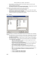
1
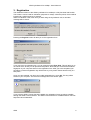
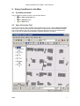
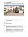
ARIS CycloSearch for ArcMap
User's Manual
ARIS B.V.
http://www.aris.nl/
Table of contents
1. Introduction...........................................................................................................................3
2. Installation.............................................................................................................................4
3. Registration...........................................................................................................................5
4. Version History......................................................................................................................6
4.1 Version 1.0......................................................................................................................6
4.2 Version 1.1.3...................................................................................................................6
4.3 Version 1.1.4...................................................................................................................6
4.4 Version 2.0......................................................................................................................6
5. Using CycloSearch in ArcMap..............................................................................................7
5.1 CycloSearch toolbar........................................................................................................7
5.2 Open Cyclorama Tool......................................................................................................7
5.3 CycloSearch Window......................................................................................................8
5.3.1 Cyclorama and toolbar..............................................................................................8
5.3.2 Table of results.........................................................................................................9
5.4 CycloSearch Settings....................................................................................................10
5.4.1 Cyclorama...............................................................................................................11
5.4.2 Search....................................................................................................................11
5.4.3 Result......................................................................................................................12
5.4.4 Graphics.................................................................................................................13
5.4.5 About button............................................................................................................13
5.4.6 OK button................................................................................................................14
5.4.7 Cancel button..........................................................................................................14
Appendix A. CycloSearch Initialization File............................................................................15
Appendix B. Example of initialization-file................................................................................18
Appendix C. License Agreement............................................................................................19
ARIS CycloSearch for ArcMap - User's Manual
1. Introduction
CycloSearch for ArcMap makes it possible to click in a Cyclorama and have CycloSearch
search for objects located at or near the position clicked at, such as addresses of houses.
Characteristics of the found objects are displayed in a list.
CycloSearch requires that ESRI’s ArcMap and Cyclomedia's CycloScope is installed.
ARIS
3
ARIS CycloSearch for ArcMap - User's Manual
2. Installation
Before you can install ARIS CycloSearch you should have installed the following:
• Microsoft .NET framework 3.5
• ArcMap 10.0 with at least ServicePack 1 (ESRI)
• CycloScope 4.7 (CycloMedia)
We refer to ESRI and CycloMedia for installation of the software.
Installation of ARIS CycloSearch is accomplished by running ARISCycloSearchAM.msi. The
Windows installer will guide you through the installation process. After installation, the
following files must be present:
• ARISCycloSearchAM.dll
• ARISCycloSearchAM.ini
• ARISCycloSearchAM.pdf
• AxInterop.CMIVVIEWLib.dll
• Interop.CMIVVIEWLib.dll
In order to be able to work with ARIS CycloSearch the user requires the following data:
• Geodataset with the positions of the Cycloramas.
• Geodataset with data to be searched to be shown as objects in CycloSearch.
• Cycloramas stored in a directory. The directory is set in CycloSearch, enabling
CycloSearch to load the Cycloramas.
Start ArcMap and select Customize | Toolbars… from the menu and check
ARIS CycloSearch to show the toolbar in ArcMap. The tool is ready to use after the settings
for in the Cyclorama, Search and Result tab are made.
ARIS
4
ARIS CycloSearch for ArcMap - User's Manual
3. Registration
The distributed version of the ARIS CycloSearch for ArcMap is a fully functional trial version.
This means it can be used for evaluation purposes for 5 days. After this period, the tool will be
locked until a valid license key is entered.
While in evaluation mode, each time you start using the CycloSearch tool, a reminder
message will be shown.
Pressing the Register button will take you to the registration form.
If you don’t have a registration key, you can press the button Buy Now!. This will take you to
our online store, where you can purchase the product. Note that you will need the hardware
fingerprint of your computer shown in the registration form. After you have completed your
purchase, a personal registration key will be sent to you by email. Please store this key in a
safe place.
Once you have entered you name and a valid registration key, press OK. This key will be
stored on your computer. The reminder message will not be shown again.
If you have the ARIS License Checker installed, the registration forms are also accessible
through the ARIS License Checker. The ARIS License Checker is available without cost from
http://www.aris.nl/download.
ARIS
5
ARIS CycloSearch for ArcMap - User's Manual
4. Version History
4.1
Version 1.0
Version 1.0 is the first release of ARIS CycloSearch for ArcMap.
4.2
Version 1.1.3
Version 1.1.3 has a number of changes compared to version 1.0
• The tool has its own toolbar in ArcMap instead of being a single tool;
• Height information can be used to narrow down the search results;
• The result list can be customized (fields of the attribute table can be added, as well as
derived values as distance to the cyclorama point, angle to the search line etc.);
• The result list can be sorted by an item of your choice, this way you influence the
object that is automatically selected.
• Possibilities to customize the symbols of the graphics.
Because of these changes new entries for the result list and the symbols of the graphics have
been added to the ini-file. Therefore, the ini-file of version 1.0 cannot be used with version
1.1.
4.3
Version 1.1.4
Version 1.1.4 is ready for use with ArcGIS 9.3 so this version is suitable for ArcGIS 9.2 and
9.3. In the Windows Start Menu a shortcut to the helpfile and website have been added.
4.4
Version 2.0
Version 2.0 of ARIS CycloSearch for ArcMap can be used with ArcGIS 10.0 (and not with
earlier versions of ArcGIS).
ARIS
6
ARIS CycloSearch for ArcMap - User's Manual
5. Using CycloSearch in ArcMap
5.1
CycloSearch toolbar
The CycloSearch toolbar contains a tool and two buttons:
•
The Open Cyclorama tool.
•
The Settings button.
•
The Help button.
5.2
Open Cyclorama Tool
The tool can only be used in ArcMap when the data view is active. Use the Open Cyclorama
tool to click in the map and open the CycloSearch window with the cyclorama that is nearest
to the point clicked in the map. The photo is pointing towards where the user clicked in the
map. In the map, a black line will indicate the viewing direction in the photo.
ARIS
7
ARIS CycloSearch for ArcMap - User's Manual
5.3
CycloSearch Window
When a Cyclorama point is found within search distance of the clicked point, the CycloSearch
window will appear. For example the following Cyclorama may be shown:
The CycloSearch Window consists of:
• The Cyclorama with a toolbar
• A table of results.
The size of the two parts can be changed by moving the splitter bar between the Cyclorama
and the list.
5.3.1 Cyclorama and toolbar
The Cyclorama photo has a toolbar with four tools. The functions of the tools are described
below:
Pointer. When clicking somewhere in the photo with the left mouse button a search
action is performed on the search layer. The found objects will be displayed in the
table of results. See chapter 5.3.2 for more details.
Turn photo. When clicking in the photo with the mouse and keeping the left mouse
button pressed down the photo will turn horizontally and/or vertically, so that the
photo will point in a different direction. The direction and distance that the mouse
position is away from the center of the photo determines the direction and speed of
the turning in the photo display. For better orientation, the viewing direction is drawn
as a black line on the map.
Zoom in. After pressing this button and pointing the mouse in the photo the photo
will zoom in (be enlarged) to where the mouse cursor was pointed in the photo.
Zoom out. After pressing this button and pointing the mouse in the photo the photo
will zoom out (show a larger extent), positioning the center of the photo to where the
mouse cursor was clicked in the photo.
ARIS
8
ARIS CycloSearch for ArcMap - User's Manual
5.3.2 Table of results
The table of results is a table located below the Cyclorama in the CycloSearch window.
When clicking in the photo using the Pointer tool CycloSearch will search the defined layer
for objects near the direction the user clicked. Information about all found objects is displayed
in the table of results. These objects could be any type of objects (for example addresses)
that are represented as a point on the map.
The table of results contains all fields as defined in the settings. Each row represents a found
object. By default, the list is sorted by distance to the cyclorama point. Therefore, the object in
the first row represents the object that meets the search criteria and is closest to the photo
point.
In the map, the area where objects are searched is drawn in orange. The found objects are
displayed in the map with a green dot. The first object of the list is selected, and drawn in red.
Clicking on a row will select that object and highlight it in red.
ARIS
9
ARIS CycloSearch for ArcMap - User's Manual
5.4
CycloSearch Settings
The CycloSearch settings can be set using the settings window or entered in the ini-file that is
located in the same location as Cyclosearch.dll. The tool cannot be used while there are
invalid settings in the ini-file. In that case the button will be disabled and you need to open the
settings window to correct the settings.
When the tool is started with an incorrect or incomplete ini-file, the program will use default
values instead.
ARIS
10
ARIS CycloSearch for ArcMap - User's Manual
5.4.1 Cyclorama
In the tab ‘Cyclorama’ 3 variables must be set:
• Cyclorama layer: the layer that contains the points where the Cyclorama’s were
taken. The layer must be present in the current map.
• Image field: a field of the layer mentioned above that contains the image id or the full
path of the images.
• Image directory: directory where the images are stored in case the image field
contains relative paths. If the image field contains full paths to the images, this
variable can be empty.
5.4.2 Search
In the tab ‘Search’ the search layer is defined and the search parameters are set:
• Search layer: the layer that contains the (point) objects to search for. The layer must
be present in the current map.
ARIS
11
ARIS CycloSearch for ArcMap - User's Manual
•
•
Search distance: the maximum distance that possible objects are from the point
where the Cyclorama was taken.
Horizontal search angle: the maximum horizontal deviation in degrees from where the
user clicked in the photo for any possible matching objects.
It is possible to include height information into the search calculations.
• Use height: check if you want to use height information.
• Height field: the field from the search layer that contains the Z-values of the objects,
this can be any numeric field or the shapefield.
• Vertical search angle: the maximum vertical deviation in degrees from where the user
clicked in the photo for any possible matching objects.
5.4.3 Result
In the tab ‘Result’ you can define what should be shown in the results list in the CycloSearch
window.
• Show field values: check any field from the search layer’s attribute table in the left list
to include it in the result list. The primary key of the search layer is always included
and cannot be unchecked.
• Show derived values: during the search action a number of values are calculated for
each matching object. You can check any of the derived values if you are interested
to see these them in the result list.
o Angle: The angle between the search line and the imaginary line from the
photo point to the matching object.
o AngleH: The horizontal angle between the search line and the imaginary line
from the photo point to the matching object.
o AngleV: The vertical angle between the search line and the imaginary line
from the photo point to the matching object.
o Dist: The distance between the matching point and the search line.
o DistH: The horizontal distance between the matching point and the search
line.
o DistV: The vertical distance between the matching point and the search line.
o DistC: The horizontal distance between the matching object and the
Cyclorama point.
o X: The X-coordinate of the matching object.
o Y: The Y-coordinate of the matching object.
o Z: The Z-coordinate of the matching object.
ARIS
12
ARIS CycloSearch for ArcMap - User's Manual
•
Sort result on: The found objects in the result list are sorted by one of the “Angle” and
“Dist” values. By selecting an item you can specify which item indicates the ‘best
match’ for your situation. The object on top of the list will be selected and highlighted
on the map.
When you are interested in the object closest to the viewing position, choose “DistC”.
When it is more important that the angle between the object and the clicked position
is as small as possible, choose “Angle”.
5.4.4 Graphics
When the CycloSearch tool is used, some graphics can be drawn on the map to visualize the
search parameters and matching objects. The symbols of these graphics can be customized
to your own needs.
• Preview: shows the preview of the symbol of the currently selected graphic
• Color: allows you to select a color (and outline color in case of a fill symbol) for the
current symbol.
• Style: select the desired style from the list.
• Size: set the size for the current symbol. Note that only solid lines can have a size
greater than 1.
• List of graphics: click on an item to preview and change the symbol. Check an item to
have it drawn in the map when using the CycloSearch tool.
o Photo viewing direction: this line on the map shows where the middle of the
Cyclorama is located.
o Search line: this line shows on the map the direction the user clicked in the
Cyclorama.
o Search area: the (horizontal) area that is searched for matching objects.
o Found objects: all objects found within the horizontal and vertical search
area.
o Selected object: the object that is closest to the search line (according to the
sortitem) or the object the user clicked on in the result list.
5.4.5 About button
Clicking this button shows general information such as the version of the tool.
ARIS
13
ARIS CycloSearch for ArcMap - User's Manual
5.4.6 OK button
Clicking the OK button will close the window and save the settings to the ini-file.
5.4.7 Cancel button
Clicking the Cancel button will close the window while leaving the settings unchanged.
ARIS
14
ARIS CycloSearch for ArcMap - User's Manual
Appendix A. CycloSearch Initialization File
Outlay of CycloSearch Initialization File
The CycloSearch initialization-file is a text file, with the layout of an initialization (.ini) file. It
consists of a number of sections. Each section is defined on a single line and is written
between enclosed brackets: [Section name].
Each section can contain item definitions. An item is defined as
ItemName = Value
Where ItemName is the name of the item and Value is the value assigned to the item.
CycloSearch Initialization File Sections
The CycloSearch initialization file may contain the following sections:
• [CYCLORAMA]
• [SEARCH]
• [RESULT]
• [SYMBOL_VIEWLINE]
• [SYMBOL_SEARCHLINE]
• [SYMBOL_SEARCHAREA]
• [SYMBOL_OBJECT]
• [SYMBOL_SELECTEDOBJECT]
• [WINDOW]
The sections CYCLORAMA and SEARCH are essential. If other sections are missing or incomplete,
the application will use default values.
[CYCLORAMA]
In the CYCLORAMA section three items must be defined. The first two items are required;
otherwise no cyclorama photos can be shown.
• layer: the layer that contains the points where the Cyclorama’s were taken. The layer
must be present in the current map.
• field_image: a field of the layer mentioned above that contains the image id or the full
path of the images.
• location: directory where the images are stored. May be empty if Field_images stores
the full paths of the cyclorama’s.
[SEACH]
In the SEARCH section at least the layer, distance and angle_horizontal must be defined. If
use_z is set to true, the remaining items must be defined too.
• layer: the layer that contains the (point) objects to search for. The layer must be
present in the current map.
• distance: the maximum distance that possible objects are from the point where the
Cyclorama was taken.
• angle_horizontal: the maximum horizontal deviation in degrees from where the user
clicked in the photo for any possible matching objects.
• use_z: whether to use height information or not, can be “true” or “false”
• field_z: a field of the layer above that contains height information, can be any numeric
field or the shapefield.
• angle_vertical: the maximum vertical deviation in degrees from where the user clicked
in the photo for any possible matching objects.
[RESULT]
The RESULT section contains no compulsory items.
• field: any field from the search layer’s attribute table that should be shown in the
result list, this item can be repeated for as many fields you want to show.
• dist: whether to show the distance to the search line or not.
• dist_horizontal; whether to show the horizontal distance to the search line or not.
ARIS
15
ARIS CycloSearch for ArcMap - User's Manual
•
•
•
•
•
•
•
•
•
dist_vertical: whether to show the vertical distance to the search line or not.
angle: whether to show the angle to the search line or not.
angle_horizontal: whether to show the horizontal angle to the search line or not.
angle_vertical: whether to show the vertical angle to the search line or not.
dist_cyclorama: whether to show the distance to the cyclorama point or not.
x: whether to show the X-coordinate of the matching point or not.
y: whether to show the YX-coordinate of the matching point or not.
z: whether to show the Z-coordinate of the matching point or not.
sortitem: one of the above keywords - except x,y and z - to specify the sorting of the
result list.
[SYMBOL_VIEWLINE]
In the SYMBOL_viewline section the symbol for drawing the view line can be defined, default
values will be used if this is omitted.
• visible: whether to show the view line or not, can be “true” or “false”
• style: the style of the view line, can be any of ESRI’s simple linestyles.
• color: RGB values of the color, separated by a semicolon.
• size: the width of the line.
[SYMBOL_SEARCHLINE]
In the SYMBOL_SEARCHLINE section the symbol for drawing the search line can be defined, default
values will be used if this is omitted.
• visible: whether to show the search line or not, can be “true” or “false”
• style: the style of the view line’s symbol, can be any of ESRI’s simple linestyles.
• color: RGB values of the color, separated by a semicolon.
• size: the width of the line.
[SYMBOL_SEARCHAREA]
In the SYMBOL_SEARCHAREA section the symbol for drawing the search area can be defined,
default values will be used if this is omitted.
• visible: whether to show the search area or not, can be “true” or “false”
• style: the style of the search area’s symbol, can be any of ESRI’s simple fills.
• color: RGB values of the fillcolor, separated by a semicolon.
• color_ol: RGB values of the outlinecolor, separated by a semicolon.
• size: the width of the outline.
[SYMBOL_OBJECT]
In the SYMBOL_OBJECT section the symbol for drawing the matching objects can be defined,
default values will be used if this is omitted.
• visible: whether to show the objects or not, can be “true” or “false”
• style: the style of the objects’s symbol, can be any of ESRI’s simple markerstyles.
• color: RGB values of the color, separated by a semicolon.
• size: the size of the symbol.
[SYMBOL_SELECTEDOBJECT]
In the SYMBOL_SELECTEDOBJECT section the symbol for the selected object can be defined, default
values will be used if this is omitted.
• visible: whether to show the selected object or not, can be “true” or “false”
• style: the style of the selected object’s symbol, can be any of ESRI’s simple
markerstyles.
• color: RGB values of the color, separated by a semicolon.
• size: the size of the symbol.
[WINDOW]
In the WINDOW section the size and position of the window can be defined, default values will be
used if this is omitted.
• size: the width and height of the CycloSearch Window, separated by a semicolon.
• location: the x- and y-coordinate of the upper left corner of the Cyclosearch window,
separated by a semicolon.
ARIS
16
ARIS CycloSearch for ArcMap - User's Manual
•
ARIS
split: the relative position of the splitter
17
ARIS CycloSearch for ArcMap - User's Manual
Appendix B. Example of initialization-file
[CYCLORAMA]
layer = Cyclorama
field_image = Image
location =
[SEARCH]
layer = Address
distance = 25
angle_horizontal = 45
use_z = False
field_z = Shape
angle_vertical = 45
[RESULT]
field = FID
field = Address
angle = True
angle_horizontal = False
angle_vertical = False
dist = True
dist_horizontal = False
dist_vertical = False
dist_cyclorama = True
x = False
y = False
z = False
sortitem = dist_cyclorama
[SYMBOL_VIEWLINE]
visible = True
style = Solid
color = 0;0;0
size = 2
[SYMBOL_SEARCHLINE]
visible = True
style = Dash
color = 255;170;0
size = 1
[SYMBOL_SEARCHAREA]
visible = True
style = Null
color = Null
color_ol = 255;170;0
size_ol = 2
[SYMBOL_OBJECT]
visible = True
style = Circle
color = 56;168;0
size = 6
[SYMBOL_SELECTEDOBJECT]
visible = True
style = Circle
color = 255;0;0
size = 6
ARIS
18
ARIS CycloSearch for ArcMap - User's Manual
Appendix C. License Agreement
ARIS Software License Agreement for ARIS CycloSearch
-----------------------------------------------------------------This is a license agreement and not an agreement for sale. This license agreement
(hereinafter referred to as AGREEMENT) is between the end user (hereinafter referred
to as LICENSEE) and ARIS b.v., The Netherlands (hereinafter referred to as ARIS), and
gives the LICENSEE certain limited rights to use the proprietary ARIS software
CycloSearch, examples, on-line and hardcopy documentation and updates (if applicable),
hereinafter referred to as PRODUCT. All rights not specifically granted in this
AGREEMENT are reserved to ARIS.
Ownership and grant of license
------------------------------------------------ARIS and its third party licensor(s) retain exclusive rights, title, and ownership of
the copy of the PRODUCT licensed under this AGREEMENT and hereby grant to LICENSEE a
personal, non-exclusive, non-transferable license to use the PRODUCT based on the
terms and conditions of this AGREEMENT. From the date of receipt, the LICENSEE shall
agree to make reasonable efforts to protect the PRODUCT from unauthorized use,
reproduction, distribution, or publication.
Copyright
--------------The PRODUCT is owned by ARIS and partly by its third party licensor(s) and is
protected by Dutch copyright laws and subject to international laws, treaties, and/or
conventions.
The LICENSEE agrees not to export the PRODUCT into a country that does not have
copyright laws that will protect ARIS's proprietary rights.
Permitted uses
----------------------The LICENSEE may use the number of copies of the PRODUCT for which license fees have
been paid on computer system(s) and/or specific computer network(s) for the LICENSEE's
own internal use.
The LICENSEE may install the number of copies of the PRODUCT for which license or
update fees have been paid onto permanent storage device(s) on computer system(s)
and/or specific computer network(s).
The LICENSEE may make one (1) copy of the PRODUCT for archival purposes only, during
the term of this AGREEMENT, unless the right to make additional copies has been
granted by ARIS to the LICENSEE in writing.
The LICENSEE may use parts of the documentation in other documents for LICENSEE's own
internal use only with the purpose of using or encouraging to use the PRODUCT.
Uses not permitted
-----------------------------The LICENSEE shall not sell, rent, lease, assign, timeshare, or transfer, in whole or
in part, or provide unlicensed third parties access to prior or present versions of
the PRODUCT, any updates, or the LICENSEE's rights under this AGREEMENT.
The LICENSEE shall not reverse, engineer, decompile, or disassemble the PRODUCT, or
make any attempt to alter the license number and other license information shown in
the about box.
The LICENSEE shall not remove or obscure any ARIS copyright or trademark notices.
The LICENSEE shall not make additional copies of the PRODUCT beyond what is laid down
in the "permitted uses" section of this AGREEMENT.
Term
-------The license granted by this AGREEMENT shall commence upon LICENSEE's receipt of the
PRODUCT and shall continue until such time as:· the LICENSEE elects to discontinue the
use of the PRODUCT;
· ARIS terminates the agreement due to the LICENSEE's material breach of this
AGREEMENT.
Upon termination of this AGREEMENT in either instance, LICENSEE shall return to ARIS
the PRODUCT and any whole or partial copies in any form. The parties hereby agree that
all provisions operating to protect the rights of ARIS shall remain in force, should
breach occur.
ARIS
19
ARIS CycloSearch for ArcMap - User's Manual
Limited Warranty
-------------------------ARIS warrants that the media upon which the PRODUCT is provided will be free from
defects in materials and workmanship under normal use and service for a period of
ninety (90) days from the date of receipt.
Except for the above express limited warranties, the PRODUCT is provided "as is",
without warranty of any kind, either express or implied, including, but not limited
to, the implied warranty of merchantability and fitness for a particular purpose.
Exclusive Remedy and Limitation of Liability
-------------------------------------------------------------------During the warranty period, ARIS's entire liability and the LICENSEE's exclusive
remedy shall be the return of the license fee paid for the PRODUCT that does not meet
ARIS's limited warranty and that is returned to ARIS or its dealers with a copy of the
LICENSEE's proof of payment.
ARIS shall not be liable for indirect, special, incidental, or consequential damages
related to LICENSEE's use of the PRODUCT, even if ARIS is advised of the possibility
of such damage.
Waivers
------------No failure or delay by ARIS in enforcing any right or remedy under this AGREEMENT
shall be construed as a waiver of any future or other exercise of such right or remedy
by ARIS.
Order of Precedence
--------------------------------Any conflict and/or inconsistency between the terms of this AGREEMENT and any purchase
order, or other terms shall be resolved in favour of the terms expressed in this
AGREEMENT, subject to Dutch law, unless agreed otherwise.
Governing Law
-----------------------This AGREEMENT is governed by the laws of the Netherlands without references to
conflict of laws principles.
Entire Agreement
--------------------------The parties agree that this constitutes the sole and entire agreement of the parties
as to the matter set forth herein and supersedes any previous agreements,
understandings, and arrangements between the parties relating hereto and is effective,
valid, and binding upon the parties.
ARIS is a registered trademark, the Netherlands.
ARIS
20